site visit reports: alaska placer mines … visit reports: alaska placer mines 2-1 2.0 site visit...
TRANSCRIPT


Site Visit Reports: Alaska Placer Mines
SITE VISIT REPORTS:ALASKA PLACER MINES

Site Visit Reports: Alaska Placer Mines
2-1
2.0 SITE VISIT REPORTS: ALASKA PLACER MINES
2.1 INTRODUCTION
This section of the Gold Placer Technical Resource Document presents summaries of three placer miningoperations: Polar Mining Inc.; Alf Hopen; and Cook's Mining. EPA visited these Alaska placer sitesduring the summer of 1992 to gain a better understanding of typical placer operations. The site visitreports are abbreviated due to the relatively limited size of each mining operation. EPA spentapproximately one-half day at each site, viewing the mining and sluicing operations.
2.2 POLAR MINING, INC.
EPA visited Polar Mining's Lower Goldstream Creek operation on July 15, 1992. The followingindividuals participated in the site visit: Dan May of Polar Mining, Inc., Kathleen M. Charlie of theAlaska Department of Natural Resources, Steve Hoffman from EPA's Mining Waste Section, and IngridRosencrantz of SAIC (EPA's contractor).
2.2.1 General Facility Description

Site Visit Reports: Alaska Placer Mines
2-2
The Polar Mining, Inc.'s Lower Goldstream operation is located on private land in Goldstream Valley,

Site Visit Reports: Alaska Placer Mines
2-3
Figure 2-1. Polar Mining, Inc., Vicinity Map
(Source: Polar Mining Inc., 1992 APMA)
approximately 12 miles northwest of downtown Fairbanks (see Figure 2-1). Originally patented in 1938

Site Visit Reports: Alaska Placer Mines
2-4
by the Fairbanks Exploration Company, the land on which Polar Mining operates is now owned by theAlaska Gold Company (Memorandum, August 9, 1988). Donald May, founder and president of PolarMining, owns and manages the mine, while his son Dan May acts as vice-president and maintenancesupervisor for the company. Polar Mining commenced work on Goldstream Creek in 1987. Thecompany "Overview" states that the mine employs 30 local residents 12 months a year on a monthlypayroll of over $100,000. The company also operates a gold placer mine on nearby Fish Creek. ("Overview," August 1, 1988; "Miners rig up converted Cat," April 14, 1991; Polar Mining, Inc., October14, 1991)
Polar Mining's Lower Goldstream operation is the largest open pit placer gold mine in the Fairbanks areain 1992. The total volume of material mined in 1992, including strippings (soils presumably used forreclamation) and overburden removed, was 2,200,000 cubic yards. The estimated volume of materialbeneficiated during the 1992 mining season was 500,000 cubic yards. Based on this information, thestripping ratio for the Lower Goldstream operation approached 4:1 (waste:ore). The total area of themining operation in 1992, including stripped areas, mining cuts, overburden and tailing stockpiles anddisposal areas, temporary stream diversions, stream bypasses, and settling ponds, is approximately 29acres. The estimate does not include the camp and access roads. (Polar Mining, Inc., 1992 AnnualPlacer Mining Application F927278)

Site Visit Reports: Alaska Placer Mines
2-5
In 1992, Polar Mining reclaimed 35 acres, both concurrently with mining and at the end of the miningseason. Polar Mining reshaped the reclaimed area to blend with the surrounding physiography usingtailings, strippings, and overburden. The company also stabilized the area so that it will retain sufficientmoisture to allow for natural revegetation. Polar Mining spread stockpiled topsoil, overburden muck, and,if necessary, settling pond silts, over the contoured mine workings to promote natural plant growth thatcan reasonably be expected to revegetate the area within five years. (Polar Mining, Inc., 1992 APMA)
Unlike most placer mines, the Lower Goldstream operation was active year-round, with the possibleexception of four weeks in late December and early January (Polar Mining's 1992 APMA indicates thatthe intended dates of operation are January 20, 1992, through December 20, 1992). Although theprojected dates of operation suggest a year-round mining operation at Lower Goldstream Creek, theestimated number of sluice days for the 1992 season was 150.
The description that follows applies to the original Lower Goldstream operation as presented in an"Overview" of Polar Mining's placer mining activities in the Fairbanks area. A 1988 NPDES Compliance
Site Visit Reports: Alaska Placer Mines
2-6
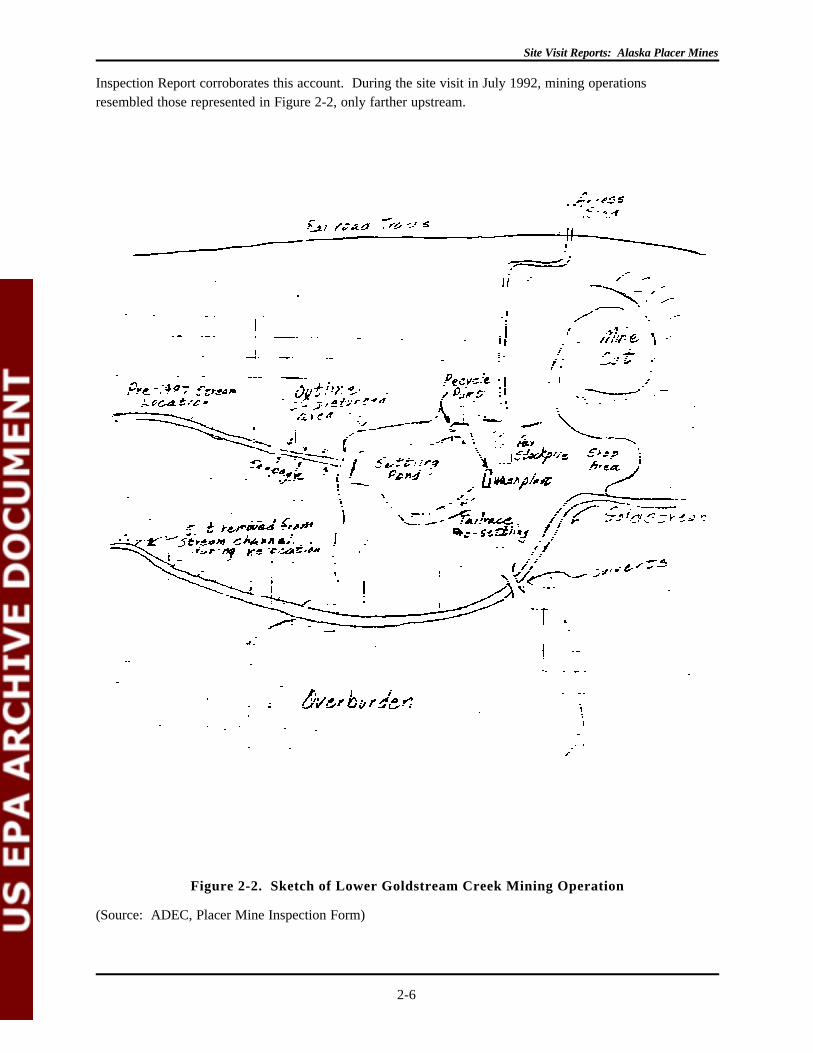
Figure 2-2. Sketch of Lower Goldstream Creek Mining Operation
(Source: ADEC, Placer Mine Inspection Form)
Inspection Report corroborates this account. During the site visit in July 1992, mining operationsresembled those represented in Figure 2-2, only farther upstream.
Site Visit Reports: Alaska Placer Mines
2-7
During the cold winter months when the ground is frozen, Polar Mining used drilling and blastingtechniques to remove frozen silt overburden, and then uses large scrapers to haul the overburden to adump site either adjacent to the mine pit or in the immediate vicinity of the pit. According to the company"Overview," since the frozen silt overburden contains very little moisture, there is no water or muddischarge into the surrounding lowlands or Goldstream Creek when the overburden thaws in the spring. During the summer, the scrapers haul the gold placer pay gravels from the bottom of the pit to a trommelwash plant and sluice box, which is 30 feet wide by 10 feet long. Overburden from the LowerGoldstream operation consists of gravel to an average depth of 10-30 feet and organic material to anaverage depth of 20 feet. Total depth to pay gravel, therefore, is approximately 30-50 feet. ("Overview,"August 1, 1988; Polar Mining, Inc., 1992 APMA)
Ground water entering the cut provides the source of make-up water, which is generated by seepageinfiltration at an estimated volume of 10 gallons per minute. Goldstream Creek does not supply any waterto the mining operation, nor does it receive any discharges. One hundred percent of the stream isbypassed by the operation, although the 1992 APMA indicates that channels are planned to connectobsolete recycle ponds to Goldstream Creek. According to the company "Overview," wash water is100% recycled and is temporarily contained in these large recycle/settling ponds before it is transported tothe recovery plant. Polar Mining did not use any chemical treatment to extract gold from the gravels. ("Overview," August 1, 1988; Polar Mining, Inc., 1992 APMA)

Site Visit Reports: Alaska Placer Mines
2-8
Before Polar Mining initiated activity at the Lower Goldstream operation in 1986, the company relocatedthe Goldstream Creek channel, diverting the Creek south of the original wash plant location and settlingpond as they are depicted in the 1988 Placer Mine Inspection Form (see Figure 2-2). Mine cuts nowfollow the original streambed. At the time of the 1988 sampling inspection, Polar Mining movedoverburden from the mine cut south across Goldstream Creek and stockpiled ore near the wash plant withscrapers. The wash plant facility consisted of a large trommel and a sluice box. Discharge from thesluice box is routed to a large recycle pond. According to the 1992 APMA, the recycle pond wasapproximately 750 feet long by 500 feet wide by 35 feet deep. A 300-horsepower pump directed thewater to the wash plant through a 12-inch return line at an estimated rate of 3,500 gallons per minute. According to an internal Environmental Quality Memorandum from Paul Bateman to Pete McGee datedAugust 9, 1988, Polar Mining used total recycle in its operations and runs a zero discharge operation. During the 1988 site visit, however, water was being pumped from the bottom of the pit and wasapparently being discharged to the tundra. During the 1992 EPA site visit, no discharges to tundra wereobserved. (Overview, August 1, 1988; Polar Mining, Inc., 1992 APMA)

Site Visit Reports: Alaska Placer Mines
2-9
The 1992 Reclamation Plan provided for two distinct mine cuts labeled 1992-1 and 1992-2 (see Figures 2-

Site Visit Reports: Alaska Placer Mines
2-10
Figure 2-3. Plan View of Lower Goldstream Creek Operation, Amended 1992
(Source: Polar Mining, Inc., 1992 APMA)
Figure 2-4. Second Plan View of Lower Goldstream Creek Operation, Amended 1992
(Source: Polar Mining, Inc., 1992 APMA)
3 and 2-4). Mine cut 1992-1 was scheduled to begin stripping operations in the late fall of 1991, whereas

Site Visit Reports: Alaska Placer Mines
1A bank cubic yard is the volume of material, usually pay dirt, equivalent to one cubic yard in situ (i.e., in its original, undisturbed place in the ground). Thisvolume does not include a swell factor or reduction in volume resulting from screening.
2-11
the second proposed cut was optional. (Polar Mining, Inc., October 14, 1991)
The proposed 1992-1 mine cut lies adjacent to and west of the 1991 mine cut. It is estimated to be 1,200feet long by 450 wide by 35 feet deep, disturbing approximately 12.4 acres. Polar Mining planned tostockpile material along the north and south sides of the cut to create two topsoil/vegetation berms,disturbing an additional 2.8 acres. Each berm will each measure 1,200 feet long by 50 feet wide (at thebase) by 12 feet high. Polar Mining plans to deposit the overburden removed from this cut in the 1991mine cut, starting from the west side. A portion of the approximately 500,000 bank cubic yards1 will alsobe used in the construction of a wide dike across the 1991 cut, dividing the cut to form a recycle pond outof the remainder of the cut. The pay gravels will be concentrated on a pad constructed on top of the dike,and the tailings that are not stockpiled for future sale will fill in the mined out cuts. (Polar Mining, Inc.,October 14, 1991)
Upon completion of the 1992-1 cut, Polar Mining planned to level the berms along the north and southsides of the cut and forge a connection between the cut and Goldstream Creek, allowing the cut to fillwith water and become a large pond as deep as 25 feet with at least one shallow sloping side. PolarMining will also leave the 1992 recycle pond open after contouring the surrounding areas.

Site Visit Reports: Alaska Placer Mines
2-12

Site Visit Reports: Alaska Placer Mines
2-13
Several shallow areas in the pond will be available for waterfowl loafing and feeding. (Polar Mining, Inc.,October 14, 1991)
Adjacent to the east side of the 1990 mine cut is the optional mine cut (1992-2). If mined, this cut wouldbe approximately 1,100 feet long by 425 feet wide by 57 feet deep, covering about 10.7 acres. Anadditional 2.5 acres along the north and south perimeters of the cut will be stockpiled, creating topsoil/vegetation berms that measure 1,100 feet long by 50 feet wide (at the base) by 12 feet high. Polar Miningplans to deposit the overburden removed from the optional cut in the de-watered 1991 recycle pond area,completely filling it in. The remainder of the approximately 800,000 bank cubic yards of overburdenwould be put in the east end of the 1991 mine cut. Polar Mining would transport the pay gravels to the1992 wash plant location and would put the tailings that are not stockpiled for future use back in the minedout cuts. Polar Mining plans to treat the 1992-2 cut like the 1992-1 cut upon completion of mining byleveling the berms and connecting the cut to Goldstream Creek. (Polar Mining, Inc., October 14, 1991)
If the optional cut (1992-2) is not mined, then Polar Mining will smooth the area around the recycle pondand connect the pond to Goldstream Creek. This pond would also have several shallow sloping areas thatmay render it acceptable for waterfowl habitat. (Polar Mining, Inc., October 14, 1991)
More than 10,000 gallons of fuel are stored on-site in above-ground tanks with capacities greater than 660gallons. Fuel containment berms surround the storage containers, but the berm area was not lined. A fuelcompany tanker truck makes an average of 55 trips per year, transporting as much as 8,000 gallons offuel per trip. The mine site is reached via an existing access road off Murphy Dome Road. Otherequipment used on-site to facilitate overburden removal, beneficiation, and reclamation activities includetwo D10 dozers, one Demag H121 excavator, three 773 rock trucks, one 988B leader, one 235 excavator,one 16G grader, and a blast hole drill rig. On an annual basis, Polar Mining used 1,200,000 pounds(approximately 600 tons) of explosives to excavate, specifically ammonium nitrate fuel oil (ANFO). (Polar Mining, Inc., 1992 APMA)
In its proposed 1992 Reclamation Plan (a section of the 1992 APMA), Polar Mining projected that, giventhe economic conditions at the time and the mining methods being used, the company was approaching theend of the current minable ore reserve at the Lower Goldstream Creek operation. Polar Mining's plansfor continued mining operations at the Lower Goldstream mine site beyond the 1992 season were unclearat the time of issuance of the 1992 Reclamation Plan. There was some discussion of a small undergroundoperation or of continued surface mining on a much smaller scale. (Polar Mining, Inc., October 14, 1992)
2.2.2 Regulatory Requirements and Compliance
Polar Mining operates its Lower Goldstream mine site with several permits. Polar Mining has been issuedan NPDES Wastewater Discharge Permit (Number AK-004635-3) by EPA.
Polar Mining was first issued the Department of the Army, Corps of Engineers (COE) "404" permit(Number 4-870729) on September 30, 1988, for the placement of 4,187,100 cubic yards of dredged and fillmaterial in 98 acres of wetlands to construct a dike, topsoil berms and overburden stockpile areas, and theplacement of fill material for reclamation activities. In December 1989 Polar Mining requested that apermit modification granting authorization to move the proposed 1990 mining cut approximately one miledownstream of the area permitted for 1990 and to construct topsoil berms for the 1991 mining season. The land previously permitted for 1990 was to be left undisturbed. To facilitate ore access and

Site Visit Reports: Alaska Placer Mines
2-14
subsequent reclamation activities, Polar Mining also requested authorization to create a pad from themajority of the fill material and expressed its intention to stabilize the pad when it finished mining from thatcut. Polar Mining intended to use previous mine cuts as process water recycle ponds or as receiving pitsfor material from the next mine cut. Polar Mining stated that the pad was necessary because not alloverburden could be returned to each completed excavation; overburden material has a swell factor of30-40%. (Department of the Army, December 17, 1991)
The COE permit (Number M-870729) was modified on January 11, 1990, to the allow Polar Mining toplace approximately 961,100 cubic yards of dredged and fill material into approximately 19.4 acres ofwetlands to stockpile topsoil and waste barren overburden for the 1990 and 1991 mining cuts. All otherconditions of the original permit remained the same. (Department of the Army, August 22, 1991)
The COE permit was again modified (Number N-870729) on August 22, 1991 to extend the time limit forcompleting the authorized work, and the modified permit now expires September 30, 1994. (Departmentof the Army, August 22, 1991)
The Alaska Department of Fish and Game (ADF&G) issued Polar Mining a permit (Number FG92-III-0002), informing the company that Goldstream Creek supports resident fish species (grayling) in the areaof the proposed channel excavations from the recycle pond to Goldstream Creek. The ADF&G advisedPolar Mining that the excavations could obstruct the efficient passage and movement of fish. TheADF&G permit included the following stipulations to reduce potential erosion and barriers to fish passage(Alaska Department of Fish and Game, January 6, 1992):
1. The outlet channel(s) shall not be connected to Goldstream Creek prior to completion of mining-related activities in the ponds;
2. The outlet channels shall be excavated to the same depth as the bottom of Goldstream Creekwhere the channels enter Goldstream Creek;
3. The outlet channels shall be 12-15 feet wide at the water surface with banks graded to a stableslope; and
4. The permittee shall plug the outlet channels (with a 100-foot plug) to the original ground surfacelevel if ADF&G identifies fish entrapment related fish kills within the ponds or potential fishentrapment related fish fills within the ponds prior to 1995.
Polar Mining does not need a permit from a state or federal land management agency to conduct itsoperations because the Goldstream Creek is on private land, although a permit is required from the COEfor the disturbance of wetlands.
EPA is not aware of any state, federal, or local government regulations for mine noise control to thesurrounding community. The Mine Health Safety Administration (MHSA), however, does regulate noiseat mines to protect workers. The MHSA and the Alaska State Mine Inspector inspected the LowerGoldstream operation on June 25, 1988, and found the mine to be in compliance with all MHSA safetyrequirements. Winter blasting was monitored by the State Mine Inspector, who coordinated with thePacific Powder Company to take seismic and decibel readings of each blast. The State Mine Inspectorfound all blasts to be within the recommended standards of noise and seismic ground shock for aresidential area.

Site Visit Reports: Alaska Placer Mines
2-15
The 1988 "Overview" mentions noise-related problems at the Lower Goldstream operation. A smallgroup of local Goldstream residents initially opposed the Lower Goldstream operation, their primarycomplaint being noise, but their first complaints were about visual impacts. To mitigate these impacts,Polar Mining constructed a large berm between the pit and the residential area to deflect noise away fromthe area homes. Polar Mining also reduced operational hours and the size of the blasts to minimize theireffects. This group of Goldstream residents requested that the Alaska Department of EnvironmentalConservation (ADEC) hold a public hearing on the ADEC certification of the COE permit. The publichearing was held on August 8, 1988 in Fairbanks. The issue of noise levels was raised, but most concernsinvolved water quality and wetlands. The State did not take any action based on this hearing ("Overview," August 1, 1988; Memorandum, August 9, 1988)
In Alaska, bonding is required for all mining operations having a mined area of five acres or greater. Thearea must be bonded for $750.00 per acre, unless the miner can demonstrate that a third party contractorcan do the required reclamation for less than that amount. Polar Mining submitted $4,350.00 to theAlaska Department of Natural Resources (DNR) for payment into the State Wide Bonding Pool to meetthe bonding requirements. (Polar Mining, 1992 APMA; Alaska DNR, State Wide Bond Pool Form)
According to the site manager, at the time of the 1992 EPA visit, the site was in compliance with all of itspermits. (Polar Mining, 1992 APMA; Alaska DNR, State Wide Bond Pool Form)

Site Visit Reports: Alaska Placer Mines
2-16
2.3 ALF HOPEN
EPA visited Alf Hopen's Little Eldorado Creek operation on July 15, 1992. The following individualsparticipated in the site visit: the operator Alf Hopen, Kathleen M. Charlie of the Alaska Department ofNatural Resources, Steve Hoffman from EPA's Mining Waste Section, and Ingrid Rosencrantz of SAIC(EPA's contractor).
2.3.1 General Facility Description
Alf Hopen operated a gold placer mine on Little Eldorado Creek in the Fairbanks mining district nearCleary, Alaska. The Little Eldorado Creek mining operation is an historic site, as evidenced by Mr.Hopen's discovery of fire pits at the site that had been used previously to thaw the layer of permafrostoverlying the pay dirt. Mr. Hopen leased the land from the Alaska Gold Company and operated on bothfederal and private (patented) claims. The 1992 Reclamation Plan for the Little Eldorado Creek operationstates that the total area to be mined in 1992 is 8 acres, excluding the camp and roads. The operatorconducted reclamation on an equal amount of acreage in 1992, both concurrently with mining and at theend of the mining season. The topographical map attached to the 1992 Annual Placer Mining Application(APMA Number F925866) suggests that work is being performed at an elevation of slightly less than1,050 feet. The site is fairly steep. Access to the mine site is by means of existing roads.
Mr. Hopen runs a seasonal operation at the Little Eldorado Creek mine site. He first started mining atthis site on August 15, 1991. The planned dates of operation for the 1992 season are May 1 throughOctober 15, with an estimated 120 sluice days during the season. Three employees work at the site. Themining operation is projected to be completed in 1992, but if work remains to be done when the seasonends, then mining and reclamation activities will be finished in 1993.
During the EPA site visit on July 15, 1992, Mr. Hopen stated that he moves 1,500 cubic yards of loosematerial daily. He estimated that this material comprises 20-30 feet of overburden and 6-8 feet of paydirt. The pay strip is narrow with some side pay. Overburden was pushed to the sides, while a backhoeshovelled the pay dirt to the washing plant, where classification with a shaker screen precedes sluicing. The 1992 Reclamation Plan states that the total volume of material mined, including strippings andoverburden, is 70,000 cubic yards. It is unclear from the references available what the ratio is of materialmoved to material concentrated. The 1992 APMA estimated that during approximately 120 days, Mr.Hopen will beneficiate 600 cubic yards of material daily, which amounts to approximately 60,000 cubicyards annually. The estimates from the 1992 Reclamation Plan and APMA for total material mined andtotal material concentrated (70,000 cubic yards and 60,000 cubic yards, respectively) suggest a very lowratio of overburden to pay dirt. No explosives are used at this site.
The Little Eldorado Creek operation employed two sluice boxes. The larger sluice box measured 20 feetlong by 4 feet wide and has a solitary channel. This sluice had 16 feet of double expanded metal riffleson nomad matting and 4 feet of hydraulic riffles that emit 4 pounds of pressure run over astroturf matting. The smaller sluice, whose dimensions are 12 feet by 34 inches, also has astroturf (door mats).
Mr. Hopen did not employ any chemical treatment in his operation. The equipment used on-site includesa D-8 and D-9 Cat bulldozer, a 980-C Cat loader, a 7/8 cubic yard Insley backhoe, a 1 1/4 cubic yarddragline, a 10x12 pump, and a 6"-pump.

Site Visit Reports: Alaska Placer Mines
2-17
Mr. Hopen had diverted Little Eldorado Creek around the mining operation. According to the 1992APMA, the diversion ditch provides that 100 percent of the creek bypasses the mine cuts. Mr. Hopenwanted to operate with 100 percent process water recycle, but actually discharged from the fourth pond. The source of the make-up water supply is ground water gain from the cut through seepage infiltration. Make-up water was added 24-hours a day at an estimated rate of 50 gallons per minute (gpm), or 70,000gallons per day (gpd). The Placer Plan Review Worksheet indicates that the sluice flow, which is theamount of water withdrawn, is 2,000 gallons per minute (gpm). The 1992 APMA indicates that theexisting dam is 150 feet long by 15 feet high, with the width of the dam at the base measuring 50 feet andnarrowing to 16 feet at the crest, but it is unclear which pond this dam blocks. The 1992 APMA indicatedthat Mr. Hopen's operation does not have a discharge. A narrative attachment to the 1992 APMA andsketch sheet states that settling ponds had to be built farther downstream than usual in order to create anarea sufficiently wide to enable the operator to safely isolate a creek bypass with no possible future ponderosion problem. Additional settling ponds will be built in newly mined cuts as mining progressesupstream. The stream will be returned to the original channel at the end of the mining season as part ofthe reclamation procedures, at which time it will be permanently channeled around the settling ponds andstabilized.
There is a large percentage of rock in the tailings that will be left behind in old cuts for stream channelingas part of the reclamation plan. All discharge water will be filtered through old dredge tailings after thesettling ponds and will not go directly into the creek. The new road will be used as a dike for a temporarystream bypass. The road will be built on dragline tailings from the old open cut.
The description of the recycle/settling pond system in the 1992 APMA differs from the EPA site visitfindings. It appears that the operator found it necessary to add a fourth pond to the planned three-pondsystem to facilitate settling so that the water would be sufficiently clear for re-use in the washing plant. The 1992 APMA (and attached sketch) indicates that the operation uses a pre-settling pond, a small pond(#1), and a larger recycle pond (#2). The site visit revealed that a pre-settling pond was not used. Instead, the main settling pond, which is 60 feet wide and 6-12 feet deep, overflowed into a smallersecondary pond below it on the hillside. The secondary pond discharges to the pump (or recycle) pond,which in turn directs water back to the wash plant for re-use. The recycle pump has 170 horsepower andfeeds water through a 12"-line at an estimated rate of 2,000 gpm. In addition to these three ponds is afourth (and final) settling pond. The Alaska Department of Environmental Conservation (ADEC)reviewed the 1992 APMA and found the water control and wastewater treatment systems adequate.
Fuel was stored onsite in tanks. Fuel containment berms surround the storage area, which were lined. Afuel truck and offsite storage vessels also function as fuel storage mechanisms. Approximately 4,600gallons of fuel may be stored at one time. A tanker truck transports approximately 4,000 gallons per trip,and the number of trips varies. As part of clean-up, Mr. Hopen burns and buries garbage. No trash isleft lying around. Waste oil is contained and removed from the mining site.
2.3.2 Regulatory Requirements and Compliance
Mr. Hopen has not received any Notices of Violation (NOVs) with respect to the Little Eldorado Creekoperation, nor has there yet been a Federal inspection.
Mr Hopen operates on Little Eldorado Creek with an NPDES Wastewater Discharge Permit (NumberAK-004451-2) from EPA. He received a turbidity modification for the NPDES permit that was

Site Visit Reports: Alaska Placer Mines
2-18
calculated using a discharge rate of 10 gpm and that permits the discharge of wastewater with a turbidityof up to 195 NTU. Discharges (seepage) greater than 10 gpm may require that the discharge be cleanerthan 195 NTU during periods of low creek flow.
Mr. Hopen also has a Corps of Engineers "404" Permit Number (D-890661). ADEC declined to reviewor comment on the Little Eldorado Creek activity as it was proposed in the COE permit application. Thisnon-action constituted a waiver of the state's opportunity to certify the proposed activity. Anymodification to the activity could require future certification.
The Alaska Department of Fish and Game (ADF&G) reviewed the 1992 APMA and decided that apermit from ADF&G was not necessary for the proposed placer mining operation on Little EldoradoCreek. The reason given by ADF&G to substantiate this decision was as follows: "The stream is notknown to support fish in the area of your proposed mining activity. Your proposed mining plan does notindicate activities will occur in waters specified by the Commissioner as important for the spawning,rearing, or migration of anadromous fish." (Letter from Ron Somerville, Deputy Commissioner, ADF&G,to Alf Hopen, February 18, 1992)
Al Hopen submitted $1,200 to the Alaska Department of Natural Resources (DNR) for payment into theState Wide Bonding Pool to meet the bonding requirements of Alaska Statute 27.19 for the disturbed areasketched and described in the 1992 APMA and Reclamation Plan. Bonding for Federal claimsencompasses the total area of the mining operation, including the camp site, access roads, and areas to bestripped for mining during the next season. For private claims, bonding covers the active mining"footprint," which does not include the camp and access roads. It does, however, include all areas thatare part of the mining operation: stripped areas, mining cuts, overburden and tailing stockpiles anddisposal areas, temporary stream diversions, stream bypasses, and settling ponds.

Site Visit Reports: Alaska Placer Mines
2-19
2.4 COOK'S MINING
EPA visited Cook's Mining Fairbanks Creek operation on July 15, 1992. The following individualsparticipated in the site visit: the operator John Cook, Kathleen M. Charlie of the Alaska Department ofNatural Resources, Steve Hoffman from EPA's Mining Waste Section, and Ingrid Rosencrantz of SAIC(EPA's contractor).
2.4.1 General Facility Description
Cook's Mining operated a gold placer mine located approximately 20 miles north of Fairbanks, Alaska onfederal mining claims (F-52493 through F-52500) at the upper head of Fairbanks Creek, a tributary of FishCreek, which flows into the Little Chena River. The Steese/White Mountains District of the Bureau ofLand Management (BLM) is responsible for the management of this land under the General Mining Lawof 1872. Patricia S. Franklin owns the claims, and John Cook operates the mine. The Upper FairbanksCreek operation is reached by following Steese Highway north toward Cleary Summit, and then takingFairbanks Creek Road five miles east of Cleary Summit. (Cook's Mining 1992 Annual Placer MiningApplication (APMA); Alaska Department of Environmental Conservation (ADEC), December 19, 1989)
The 1992 mining season represented the fifteenth year of production at the Upper Fairbanks Creek site,and Cook's Mining anticipated that two years remain before the site will be closed. (Cook's Mining,March 31, 1992). The 1992 APMA was the source of the following general facility description.
Cook's Mining operated on a seasonal basis from approximately June 1 through October 1, employingthree to four workers. The company worked an estimated 100 sluice days during the mining season. Thetotal volume of material to be mined in 1992, including strippings and overburden to be removed, was200,000 cubic yards. The estimated volume of material beneficiated during the 1992 mining season was65,000 cubic yards. Based on this information, the stripping ratio for the Cook's Mining Upper FairbanksCreek operation was approximately 3:1 (waste:ore). The total area of the mining operation in 1992,including stripped areas, mining cuts, overburden and tailing stockpiles and disposal areas, temporarystream diversions, stream bypasses, and settling ponds, was approximately 5-6 acres. The estimate doesnot include the camp and access roads (Cook's Mining, 1992 APMA).
In 1992, Cook's Mining planned to reclaim 10-15 acres, both concurrently with mining and at the end ofthe mining season. Cook's Mining will reshape the site to blend with surrounding physiography using minetailings and overburden. The company will spread stockpiled topsoil/organic debris over the reshaped site. Cook's Mining will ensure that fine sediment captured in the settling ponds is protected from washout andleft in a stable condition at the end of the season. Finally, Cook's Mining will restore disturbed streamareas to facilitate natural restoration of fish and wildlife habitat. (ADEC, Decision Record, December 19,1989)
Cook's Mining removed approximately 31 feet of overburden, consisting of 30 feet of gravel and one footof organic material. Cook's Mining then fed the pay gravels to a trommel wash plant and sluice box,which measures 24 feet long by four feet wide and has three channels with a 2:1 slope. Cook's Miningconcentrates an estimated 700 cubic yards of material daily. No chemical treatment is used at the UpperFairbanks Creek operation. (Cook's Mining, 1992 APMA)

Site Visit Reports: Alaska Placer Mines
2-20
Ground-water gain from the mine cut and Fairbanks Creek supply the make-up water. Stream flow atthis point in the valley is 300 to 400 gallons per minute, while ground-water infiltration can add another 50gallons per minute. The Fairbanks Creek operation has an intermittent, variable discharge. When Cook'sMining began sluicing for a new cut, it can take up to two weeks for the stream to fill a new recycle pond. Until the pond fills, there is no discharge; after it fills, there is a discharge of 300-400 gallons per minute,24 hours a day, seven days a week.
The operation is near the head of the valley where the stream runs at a low volume. Cook's Mining needsthe stream flow as make-up water for the ponds to keep up with the outgoing pond seepage that woulddiminish the reservoirs if the company diverted the stream around the mine site. However, Cook's Miningtried to divert the stream to one side of the cut or the other whenever it is feasible so that the equipmentdoes not run in the stream while mining activities are in progress. Since the valley is extremely narrowand has steep sides, Cook's Mining cannot make the stream fully bypass the mining cut or ponds withoutconstructing a large, expensive notch along the length of the south side of the valley, which would destroythe hillside and would not serve any practical purpose. The quality of the water discharge from the minesite has been good enough that Cook's Mining does not find it necessary to construct such a drasticstream bypass. Fairbanks Creek filters through several miles of dredge tailings downstream from theCook's Mining operation, then emerges again as surface flow. (Cook's Mining, attachment to 1992APMA; Cook's Mining, "Mining Plans," 1987)
As the mining operations advance, the valley narrows, and the wet groundcover associated with thebottom of the valley diminishes. As of March 31, 1992, approximately 40 feet of valley bottom width wasconsidered wet groundcover. Cook's Mining removed this material and stacked it on the hillside to forman overburden pile 75 feet wide by 1,800 feet long, by 40 feet high. (Cook's Mining, March 31, 1992)
Cook's Mining operated two pay channels in this valley, one being the lower channel previously describedas having 40 feet of wet groundcover. Cook's Mining was uncovering a bench deposit on the north slopeof the valley. This is a very dry hillside area, and the overburden that is removed from this bench ispushed directly into the previous bench cut that was just mined. Dry material is therefore being pushedinto a dry hole in the hillside far from the bottom of the valley. (Cook's Mining, March 31, 1992)
Ponds were planned for the lowest point of the valley on the cleaned bedrock, and six berms will line theponds and measure 100 feet long, by 45 feet wide, by 25 feet tall. Cook's Mining will build these bermsusing the material previously accounted for in the overburden piles stacked along the side of the cut on thesouth side of the valley. (Cook's Mining, March 31, 1992)
The recycle/settling pond system had been built in mining cuts behind the most current operation as itprogresses up the valley. Each pond differs from the others because the overburden from new cuts isdeposited in previous cuts, and then the company builds settling ponds from the area available after itfinishes stripping the cuts. Although the ponds vary significantly, an average set of dimensions for one ofCook's Mining's settling ponds is 200 feet long by 100 feet wide by 30 feet deep. The recycle pump is a60-horsepower instrument that sends an estimated 800 gallons per minute of water through an 8-inchreturn line.
There is at least one existing dam and at least one more dam to be constructed. The existing dam isdescribed as being 150 feet long and 30-50 feet high. The width of the dam is 40 feet at the crest and 75-100 feet at the base.

Site Visit Reports: Alaska Placer Mines
2-21
Approximately 3,000 gallons of fuel are stored on-site in tanks with capacities larger than 660 gallons andin a tanker on wheels. Fuel containment berms do not surround the fuel storage containers. A truck fromtown transports approximately 2,500 gallons of fuel on each of its 10 trips to the site.
Cook's Mining uses the following equipment to accomplish the tasks described: two John Deere 850dozers to strip and push pay dirt; one Cat 225 excavator to divert the stream, prospect, and sluice; oneJohn Deere 444 rubber tire loader to move tailings; one D9L Cat dozer for stripping; and miscellaneoustrucks, pumps, and generators to support the stripping and sluicing activities.
2.4.2 Regulatory Requirements and Compliance
Cook's Mining had an NPDES permit (Number AK-004632-9) from EPA. EPA granted Cook's Mining aturbidity modification that allows the company to discharge waste water with a turbidity of up to 16nephelometric turbidity units (NTU), a modification that was calculated using a discharge rate of 50gallons per minute. Seepage greater than 50 gallons per minute could require Cook's Mining to maintain adischarge cleaner than 16 NTU during periods of low creek flow. (ADEC, April 7, 1992) SinceFairbanks Creek is not known to support fish in the area of the Cook's Mining operation, the AlaskaDepartment of Fish and Game (ADF&G) did not require a permit.
In Alaska, bonding is required for all mining operations having a mined area of five acres or greater. Thearea must be bonded for $750.00 per acre, unless the miner can demonstrate that a third party contractorcan do the required reclamation for less than that amount. Cook's Mining submitted $2,250.00 to theAlaska Department of Natural Resources (DNR) for payment into the State Wide Bonding Pool to meetthe bonding requirements. (Cook's Mining, 1992 APMA; Alaska DNR, State Wide Bond Pool Form)

Site Visit Reports: Alaska Placer Mines
2-22
2.5 REFERENCES
Alaska Annual Placer Mining Application, with attachments, February 3, 1992.
Alaska Placer Plan Review Worksheet, April 3, 1992.
Alaska Department of Environmental Conservation. 1992a (March 20). Letter from William D. McGee,Alaska Department of Environmental Conservation, to Alf Hopen.
Alaska Department of Environmental Conservation. 1992b (April 7). Letter from William D. Morgan,Alaska Department of Environmental Conservation, to Alf Hopen.
Alaska Department of Environmental Conservation. 1992c (April 7). Letter from William D. Morgan toJohn Cook, Cook's Mining.
Alaska Department of Environmental Conservation. December 19, 1989. Decision Record, withattachments.
Alaska Department of Environmental Conservation. June 3, 1988. Placer Mine Inspection Form, with anEPA NPDES Compliance Inspection Report cover sheet dated August 2, 1988 and signed byConrad Christianson.
Alaska Department of Fish and Game. 1992a (January 6). Letter to Dan May, Polar Mining, Inc.
Alaska Department of Fish and Game. 1992b (February 18). Letter from Ron Somerville, AlaskaDepartment of Fish and Game, to Alf Hopen.
Alaska Division of Mining Approved Reclamation Plan, approved by John E. Wood, May 6, 1992.
Alaska Department of Natural Resources Case File Abstract, February 21, 1992.
Alaska Department of Natural Resources State Wide Bond Pool Form, April 27, 1992.
Alaska Department of Natural Resources. 1988 (August 1). "Overview: Polar Mining, Inc." Anexecutive summary of the Lower Goldstream operation faxed from the Alaska Department ofNatural Resources.
Cook's Mining. 1987. "Mining Plans." Letter from John Cook; recipient unknown.
Cook's Mining. 1992a (January 6). 1992 Annual Placer Mining Application (Number F926973), withattachments. Submitted to the Alaska Department of Environmental Conservation by John Cook.
Cook's Mining. 1992b (March 31). Letter from John Cook to Kevin Morgan, Department of the Army.
Memorandum. August 9, 1988. From Paul Bateman to Pete McGee regarding Public Hearing Summary.
Polar Mining, Inc., 1992 Annual Placer Mining Application (Number F927278), with attached maps. December 23, 1991. Signed by Dan May, Operator, Polar Mining, Inc.
Polar Mining, Inc. October 14, 1991. Letter from Daniel May to the Reclamation Commissioner,Division of Mining, with enclosed sketches.
United States Department of the Interior, Bureau of Land Management. Environmental Assessment (EALog Number AK-080-89-041).
U.S. Department of the Army, U.S. Army Engineer District, Alaska. 1991 (August 22). Permitmodification issued by Timothy R. Jennings to Polar Mining, Inc.
Site Visit Reports: Alaska Placer Mines
2-23
U.S. Department of the Army. December 17, 1991. Letter from Timothy R. Jennings to William D.McGee, with enclosed sketches.