site investigations for offshore wind · • consider pre-existing geological data and key ......
TRANSCRIPT

13/12/2010
1
Site Investigations for gOffshore Wind
A multi-disciplinary approach
M ttij d LMattijs de Lange
Gardline Marine Sciences Limited
My thanks to:
• Maarten Timmerman
• David Cerda Saltzman
• Sue Crothers
• Albert van der Hem
• Cliff Whatrup
13/12/2010
2
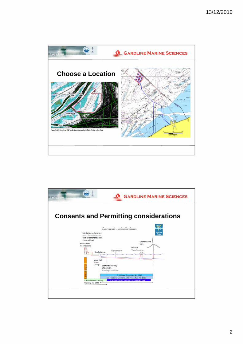
Choose a Location
Consents and Permitting considerations
13/12/2010
3
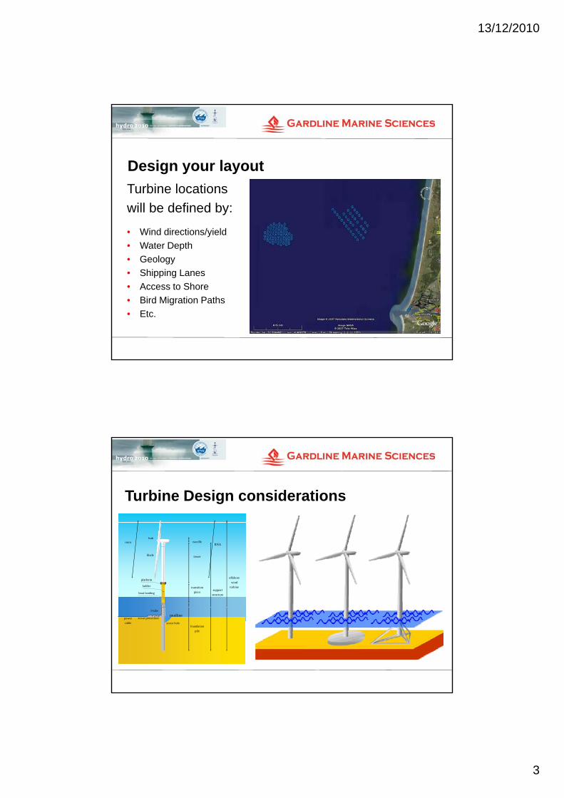
Design your layout
Turbine locationsTurbine locations
will be defined by:
• Wind directions/yield
• Water Depth
• Geology
• Shipping LanesShipping Lanes
• Access to Shore
• Bird Migration Paths
• Etc.
Turbine Design considerations
offshore
wind
turbinesupport
structure
RNAnacelle
tower
transition
piece
rotor
blade
hub
platform
ladder
boat landing
offshore
wind
turbinesupport
structure
RNAnacelle
tower
transition
piece
rotor
blade
hub
platform
ladder
boat landing
offshore
wind
turbinesupport
structure
RNAnacelle
tower
transition
piece
rotor
blade
hub
platform
ladder
boat landing
foundation
pile
scour protection
scour hole
J-tube
power
cable
mudline
foundation
pile
scour protection
scour hole
J-tube
power
cablefoundation
pile
scour protection
scour hole
J-tube
power
cable
mudline

13/12/2010
4
Forces on Foundations
air
wind
air
wind
air
wind
sea
soil
waves ¤t sea
soil
waves ¤t sea
soil
waves ¤t
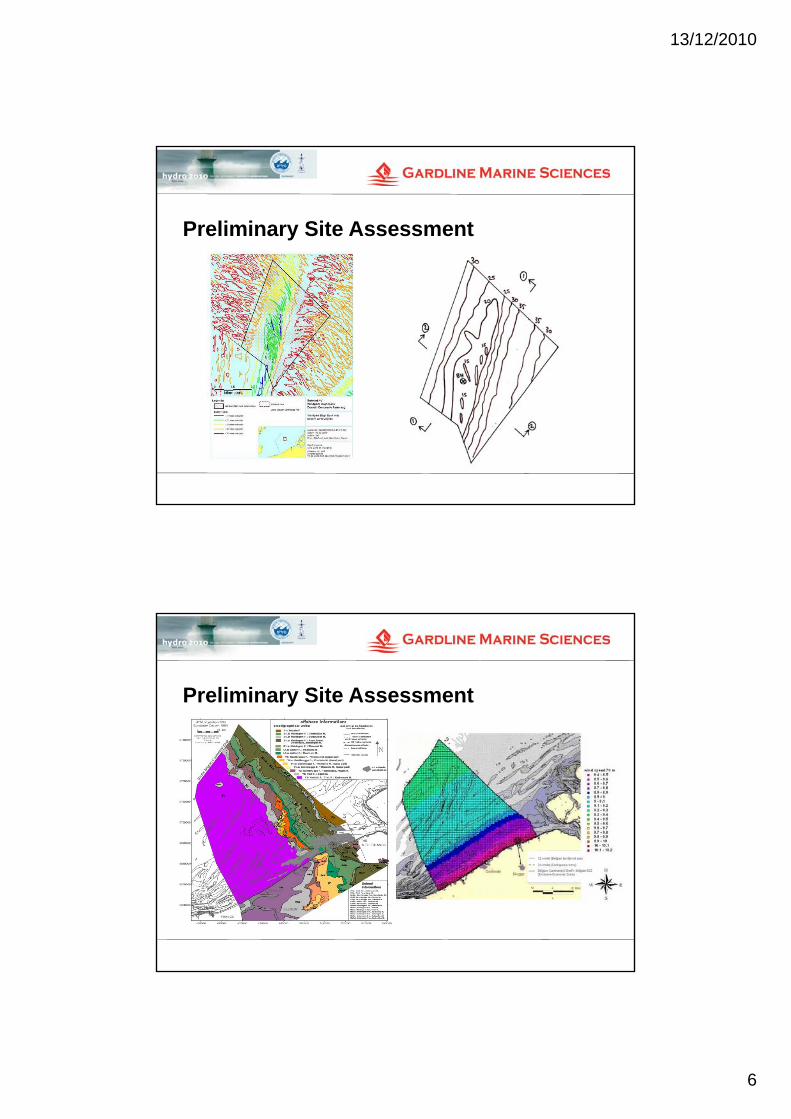
Preliminary Site Assessment
• Review existing data and undertake a desk study.
• Consider Pre-Existing Geological data and key geological processes
• Preliminary met ocean conditions
• Identify geotechnical risks
• Identify areas of insufficient information
• Outline scope of survey

13/12/2010
5
Preliminary Site Assessment
Preliminary Site Assessment
13/12/2010
6
Preliminary Site Assessment
Preliminary Site Assessment

13/12/2010
7
A Cautionary Note• No recognised guidelines on survey practice for wind farms similar to those
outlined for oil and gas by UKOOAoutlined for oil and gas by UKOOA
An up to date replacement for SUT’s OSIG 2005 guidance notes on “Site Investigation for Offshore Renewable Energy Projects” not yet published
• Client knowledge based upon previous experience in the design of offshore wind-farms has been very limited due to inexperience and lack of engagement with Oil & Gas sector.
• There is always a need to minimise survey costs. Funding to do a “proper j b” f th l d ft l ti f f l t fjob” of the survey only approved after completion of a formal acceptance of an Environmental Impact Assessment….
• … but survey work is required for a comprehensive EIA … archaeology, UXO and habitat assessments
Site Investigations
N d t f ll th b th t d• Need to ensure full swathe bathymetry and sonar coverage over survey area
• Ensure sub-bottom profiler data below all probable turbine locations (piling locations), to anticipated pile depth
• Probable need to “see” below the multiple in shallow water, and map the refusal surface for foundation design.(Consider the use of multi channel techniques)(Consider the use of multi-channel techniques)
• Detailed shallow penetration geophysics for cable routes and jack-up leg penetration
• Different tasks have different requirements:

13/12/2010
8
Consider what you need from your data
and / or
Survey Scope – Phase 1 - Geophysics
D id th d f i• Decide on the need for a reconnaissance or detailed IHO Order 1survey over the whole site
• Establish bathymetry using swathe systems
• Indentify and locate seabed hazards
• Determine geometry of subsurface layers
• Develop your scope for detailed survey or subsequent geotechnical investigations

13/12/2010
9
The Right Survey Vessels
The Right Equipment

13/12/2010
10
The Right People
Bathymetry

13/12/2010
11
Sea Bed Features
Sub-bottom Geology

13/12/2010
12
Survey Scope – Phase 2 - Geotechnics
• Thickness and properties of seabed layersThickness and properties of seabed layers
• Complexity of the geological model
• Presence and distribution of hazardous layers
• Variability and uncertainty in geotechnicalVariability and uncertainty in geotechnical parameters
• Number of CPT tests vs. Number of Boreholes
The Right Drill Vessels

13/12/2010
13
The Right Equipment
The Right People

13/12/2010
14
Geotechnical Surveys Provide
Refined geological model• Refined geological model
• Variation in ground conditions
• Idealised ground profile at foundation location
• Geotechnical parameters for foundation• Geotechnical parameters for foundation design
• Identification of geotechnical hazards
Geotechnical Survey Results

13/12/2010
15
Geotechnical Survey Results
Refined Geological Model

13/12/2010
16
Parameters for Foundation Design
Metocean Data

13/12/2010
17
Metocean Data
Data Integration and Reporting
Data comparison
over time

13/12/2010
18
Data Integration and Reporting• Wind turbine suitability mapping:
Data Integration and Reporting• 3D visualisation example with data from different sources:

13/12/2010
19
Foundation Design
scour protectionscour hole
mudlinescour protection
scour hole
mudline• Length
• Diameter
Foundation Design

13/12/2010
20
Foundation Design
Q tiQuestions
Mattijs de Lange
Gardline Marine Sciences Limited