site inspection and monitoring uranium mill tailings ...the uranium mill tailings radiation control...
TRANSCRIPT

Long-Term Surveillance and Monitoring Program
Annual Site Inspection and Monitoring Report for Uranium Mill Tailings Radiation Control Act Title I Disposal Sites
Annual Report for the Period January 1,1998, Through December 31,1998
February 1999

This file contains inspection data for the Shiprock Site only.

Long-Term Surveillance and Monitoring Program
Annual Site inspection and Monitoring Report for
Uranium Mill Tailings Radiation Control Act Title I Disposal Sites
1998 Annual Report
February 1999
Prepared for U.S. Department of Energy
Albuquerque Operations Office Grand Junction, Colorado
Work Performed Under DOE Contract Number DE-AC13-966587335 Task Order Number MAC 99-06
Document Number SO0184

Contents
Page
1.0 Introduction . . . . . . . . . . . . . . . . . . . . . . . . . . . . . . . . . . . . . . . . . . . . . . . . . . . . . . . . . . SHP-I
2.0 Results of Inspection . . . . . . . . . . . . . . . . . . . . . . . . . . . . . . . . . . . . . . . . . . . . . . . . . . . SHP-1 2.1 Specific Site Surveillance Features . . . . . . . . . . . . . . . . . . . . . . . . . . . . . . . . . . SHP-2 2.2 Transects . . . . . . . . . . . . . . . . . . . . . . . . . . . . . . . . . . . . . . . . . . . . . . . . . . . . . . SHP-5
3.0 Ground-Water Monitoring . . . . . . . . . . . . . . . . . . . . . . . . . . . . . . . . . . . . . . . . . SHP-7
4.0 Conclusions . . . . . . . . . . . . . . . . . . . . . . . . . . . . . . . . . . . . . . . . . . . . . . . . . . . . . . . . . SHP-7
5.0 Photographs . . . . . . . . . . . . . . . . . . . . . . . . . . . . . . . . . . . . . . . . . . . . . . . . . . . . . . . . . . SHP-7
Figures
Figure SHP.1 . Shiprock. New Mexico. 1998 Inspection Drawing .................... SHP-3
Tables
Table SHP.1 . Photographs taken at Shiprock. New Mexico. Disposal Site . . . . . . . . . . . . SHP-7
DOElGrand Junction Off~ce LTSM 1998 UMTRCA Title I Annual Repon February 1999 iii
This page intentionally blank

Summary
The site, inspected on June 17, 1998, is in good condition. Encroachment of vegetation, primarily tumbleweeds, continues on the disposal cell. On several occasions, DOE has sprayed the plants with herbicides. The last application was in the fall of 1997. The herbicide was a pre- emergent that may last longer than one growing season. The weeds are expected to return, however, because the riprap is a favorable environment for these weeds and there is a steady supply of seeds from offsite. Removal of tumbleweed from along the security fence is the only maintenance task identified during this year's inspection. Inspectors identified no requirement for a follow-up inspection at this site.
1.0 Introduction
This report presents the results of the U.S. Department of Energy's (DOE'S) annual inspection of the Uranium Mill Tailings Radiation Control Act (UMTRCA) Title I disposal site at Shiprock, New Mexico.
M.J. Gardner, Chief Inspector, and W.J. Waugh, Assistant Inspector, both of MACTEC-ERS, the Technical Assistance and Remediation contractor at the DOE Grand Junction Office (GJO), conducted the inspection on June 17,1998. The inspection was conducted in accordance with (1) the LTSP (Long-Term Surveillance Plan for the Shiprock Disposal Site, Shiprock, New Mexico, September 1994. 'u.s. DOE, Albuquerque, N.M., DOElALl62350-60F, Rev. 1) for this site and (2) procedures established by the GJO to comply with requirements of Title 10 Code of Federal Regulations Part 40.27.
The purposes of the annual inspection were to confirm the integrity of visible features at the site, to identify changes in conditions that may affect site integtity, and to determine the need, if any, for maintenance or additional inspections and monitoring.
2.0 Results of Inspection
To ensure a thorough and eficient inspection, the site was divided into three areas referred to as transects: (1) the riprapped top of the disposal cell, side slopes, diversion channels, and outflow channel; (2) the terrace north and northeast of the disposal cell, and (3) outlying areas. Each of these transects was inspected by walking a series of traverses. Parts of the outlying areas transect were inspected from a distance.
Within each transect, inspectors examined specific site surveillance features, such as survey and boundary monuments, signs, and site markers. Inspectors examined each transect for evidence of erosion, settling, slumping, or other phenomena that might affect site integrity or the long-term performance of the site. Features mentioned in this report are shown on the drawing, Figure SHP-1.
DOUGrand Junction Oflice LTSM 1998 UWRCA Title I Annual Repon February 1999 SHP-1

2.1 Specific Site Surveillance Features
Entrance ~a t e s -and Signs
All three entrance gates-the new main entrance gate at the east comer of the site (near the terrace escarpment), the gate at the north comer of the site that provides access to the northern part of the terrace escarpment, and the old entrance gate at the southwest comer of the s i t e w e r e in good condition. The entrance signs at these gates, El, E2, and E3, were also in good condition.
Perimeter Fence and Signs
The security fence along the site boundary is in good condition. It remains damaged along the Navajo Engineering and Construction Authority (NECA) property on the west, but still provides a full security.
In 1996, the security fence along the terrace, north and northeast of the disposal cell, was removed to stop tumbleweeds from accumulating along the fence. Tumbleweeds do, however, continue to accumulate along the fence at other places. At the time of this year's inspection, there were significant tumbleweed accumulations along the west security fence (SHP PL-1, SHP PL-2, and SHP PL-3); in the southeast comer of the fence, near the old entrance gate (SHP PL-4); in the vicinity of perimeter sign P16 (both inside and outside the fence); near entrance sign E3 on the outside of the fence; outside the fence near boundary monument BM-2; and in the vicinity of boundary monument BM-6. The accumulations were so thick at BM-6 that the monument could not be inspected. Tumbleweeds will be removed so that the fence and site surveillance features along the fence can be properly inspected and to improve the appearance of the site.
A small to moderate amount of windblown trash is caught in the fence between perimeter signs P1 and P3 and between perimeter signs PI9 and P16 (SHP PL-1 through SHP PL-4). Trash will be removed as part of the tumbleweed removal project.
Perimeter signs are attached to the security fence in pairs, one standard DOE sign above and one pictorial sign below. There are 18 pairs of perimeter signs. All are in good condition except perimeter sign P17. The paint on the pictorial warning at P17 is peeling. It is still legible, but eventually will have to be replaced.
Site Markers
There are two site markers: SMK-1;just inside the old entrance gate at the southem comer of the site; and SMK-2, on top of the disposal cell. Both are in good condition, although the concrete around the base of SMK-1 has a few hairline cracks.
LTSM 1998 UMTRCA Title I Annual Repon DOWGrand Junction Onice SHP-2 February 1999

EXPLANATION 0 250 500 SCALE FEET
M ENTRANCE GATE ENTRANCE SlGN AND NUMBER
PERIMETER SlGN AND NUMBER
SITE MARKER AND NUMBER
0' BOUNDARY MONUMENT (EM) AND NUMBER
0' COMBINED SURVEY MONUMENT/ BOUNOARY MONUMENT AND NUMBER
@' MONITOR W L L AND NUMBER
0' SETTLEMENT PLATE AND NUMBER - - - - PROPERTY BOUNOARY - - A - DlMRSlON CHANNEL AND FLOW DIRECTION
TOP OF ESCARPMENT +- SECURITY FENCE
BARBED-WIRE FENCE
$ EROSION CONTROL MARKER AND NUMBER
U S BUREAU OF RECLAMATION BENCH MARK
63 U S GENERAL LAND OFFICE TOWSHIP AN0 SECTION UNE MARKER
PHOTOGRAPH LOCATION AND NUMBER
e O U m O W CHANNEL AND DIRECTION
0 SOIL MOISNRE MONITORING NBE/LOCATION
U.S. OE&A,RY&N& S S N E R G Y h\cldec-m C R N IUHCMH. m w m
SHIPROCK, NEW MEXICO 1 4 4 R
INSPECTION DRAWlNG O A K PREPARED FILENWE:
cnnln-nn
Survey Monuments and Boundary Monuments
Two of the three survey monuments, SM-1 and SM-3, were undisturbed and in good condition. Previous inspection reports noted that rocks in the soil near survey monument SM-2 may have settled and moved away from the base of the monument, thus raising the question whether the monument too may have moved. SM-2 and the area around it now appear stable. The monument may have been reset when the site was resurveyed in 1996. Survey coordinates for this monument will be checked before it is used as a survey control point, but the monument in its current state and position is sufficient as a visual reference to locate the site boundary.
The LTSP states that there are eight boundary monuments at the site. During this year's inspection, BM-1 through BM-5 and BM-8 were found; BM-6 and BM-7 were not. The location of BM-6 is in an area of dense tumbleweed accumulation. The monument may be present, only hidden by weeds. Monument BM-7 is apparently destroyed. It is not essential because it is an outlier and not on the site boundary. If it is ever needed, it can be reestablished by resurvey.
Erosion Control Markers
There are four pairs of erosion control markers along the edge of the terrace escarpment: El and E1A; E2 and E2A; E3 and E3A, and E5 and E5A. All markers are in good condition. None has been lost to retreat of the escarpment.
2.2 Transects
Top, Side Slopes, Diversion Channels, and Outflow Channel
The top and side slopes of the disposal cell are covered with riprap. (Strictly speaking, the rock is not riprap but river-rounded quartzite that ranges in size from cobbles to small boulders. The rock is not crushed.) The rock is extremely hard, durable, and in good condition. No evidence of settling, erosion, or animal burrowing was found in any "riprapped" area.
Diversion channels around the base of the disposal cell (on all sides except the southeast) are in good condition. Encroachment of plants in the northwest diversion channel, reported previously, was controlled by herbicide spraying in November 1997.
Offsite drainage is directed toward the outflow channel at the northwest corner of the site. Rock cover in the outflow channel was in good condition. Vegetation in the outflow channel, primarily kochia, Russian thistle, and tamarisk, was mostly dead as a result of herbicide spraying and is not at this time a threat to channel performance in event of a heavy storm. Tamarisk will continue to be controlled with appropriate herbicide on an as-needed basis. (See Plant Encroachment, below.)
Plant Encroachment. Populations of tumbleweeds (Russian thistle and kochia) grow annually on the top of the disposal cell and on the east, northeast, and northwest side slopes. These plants
DO'iJGrand Junction Ofiice LTSM 1998 UMTRCA Title I Annual Report February 1999 SHP-5

were sprayed with systemic herbicides in 1996 and 1997 without lasting effect. The plants are annuals that sprout each year from windblown seeds.
A preemergent herbicide was applied to the ground in November 1997 with some expectation that the preemergent might be effective over more than one mowing season. The intention was - - - - for the preemergent herbicide to wash off the riprap and impregnate the underlying soil layer. This apparently happened. During this year's inspection only a few small patches of weeds were present. These included kochia, Russian thistle, prickly lettuce, Jim Hill mustard, grey horsebrush, and rabbitbrush (SHP PL-5 through SHP PL-11). Several specimens of rabbitbrush showed injury from the preemergent herbicide, but the plants were still alive (SHP PL-11).
A special herbicide is used to control tamarisk. It is applied topically to the plant when fully leafed out. Tamarisk was last treated in 1996, and the control seems to be effective.
Terrace
The terrace is that area between the north and northeast edge of the disposal cell and the escarpment above the San Juan River. No erosion on the terrace or mass wasting along the edge of the escarpment was seen.
A small stand of greasewood was noted on the northeast terrace near monitor well MW-1 (PL-12). Greasewood is a phreatophyte. Its survival depends upon a supply of water relatively near the surface. It is unlikely that these plants rely on ground water as deep as the floodplain that lies 70 feet (ft) in elevation below the disposal cell.
Outlying Areas
The area outward from the disposal site for a distance of 0.25 mile was visually inspected.
NECA Gravel Pit Ooerations. A sand and gravel operation by the NECA is present southeast of the site. At the timiof the 1997 inspection, sand i d gravel operations weriapproximately 1.50 yards from the southeast site boundary. During the 1998 inspection, inspectors noted that . - gravel pit activity appeared to be limited mostly tokaffic from &cks and heavy equipment and the stockpiling of excavated gravel pit materials. Although there is significant activity in this area, the current gravel pit operations do not appear to pose an immediate risk or threat to the disposal cell. To ensure DOE access to the disposal cell along the east side of the site, and to ensure that gravel pit operations do not encroach upon the site perimeter, DOE will continue to monitor these operations.
Borrow Area. A borrow area from which radon barrier material was obtained is across the public road south of the disposal cell. The area is fenced. In 1995, the DOE-AL Environmental Restoration Division (ERD)-Uranium Mill Tailings Remedial Action (UMTRA) Office armored drainage channels on a side slope of the borrow area to channel storm water into the bottom of the borrow. The borrow area was also reseeded at that time. In July 1996, several of the armored drainage channels were damaged by erosion after heavy rains. ERD-UMTRA was to
LTSM 1998 UMTRCA TiUe I Annual RepoR WUCRand Junction Oftice SHP-6 February 1999
--repair the erosion damage in the fall of 1996. Inspectors, in 1997 and this year, could not determine if these repairs were made.
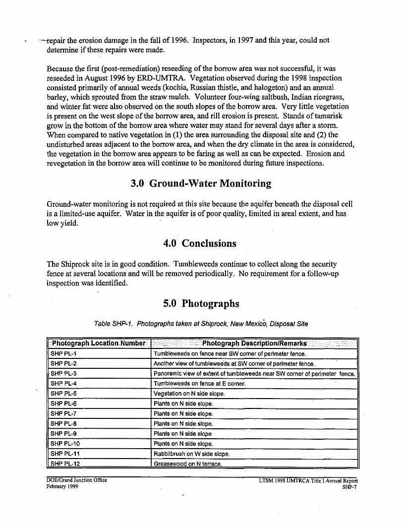
Because the fust (post-remediation) reseeding of the borrow area was not successful, it was reseeded in August 1996 by ERD-UMTRA. Vegetation observed during the 1998 inspection consisted primarily of annual weeds (kochia, Russian thistle, and halogeton) and an annual barley, which sprouted fiom the straw mulch. Volunteer four-wing saltbush, Indian ricegrass, and winter fat were also observed on the south slopes of the borrow area. Very little vegetation is present on the west slope of the borrow area, and rill erosion is present. Stands of tamarisk grow in the bottom of the borrow area where water may stand for several days after a storm. When compared to native vegetation in (1) the area surrounding the disposal site and (2) the undisturbed areas adjacent to the borrow area, and when the dry climate in the area is considered, the vegetation in the borrow area appears to be faring as well as can be expected. Erosion and revegetation in the borrow area will continue to be monitored during future inspections.
3.0 Ground-Water Monitoring
Ground-water monitoring is not required at this site because the aquifer beneath the disposal cell is a limited-use aquifer. Water in the aquifer is of poor quality, limited in areal extent, and has low yield.
4.0 Conclusions
The Shiprock site is in good condition. Tumbleweeds continue to collect along the security fence at several locations and will be removed periodically. No requirement for a follow-up inspection was identified.
5.0 Photographs
Table SHP-1. Photographs taken at Shiprock, New ~exicb, Disposal Site
WE/Cnand Junction Ofice LTSM 1998 UMTRCA Title I Annual Report February 1999 SHP-7
This page intentionally blank

;HP 6198 Vegotatian on N side slops.


-11 SHP 6 -. - -- k