site clearance - t. baker smith · site clearance solutions start here ... tbs offers scanning...
TRANSCRIPT
Regulatory Filings
Trawl Surveys
Scanning Sonar Surveys
Reports
Positioning
Verification Inspection Services
Planning | Environmental | Surveying | Engineering | GIS/Mapping
SITECLEARANCE
SOLUTIONS START HERE • 866 .357 .1050 • tbsmi th .com • SOLUTIONS START HERE
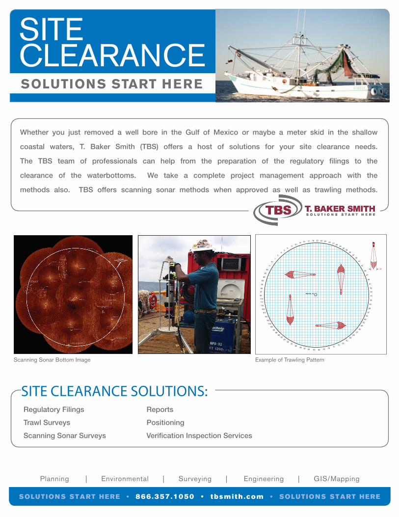
Whether you just removed a well bore in the Gulf of Mexico or maybe a meter skid in the shallow
coastal waters, T. Baker Smith (TBS) offers a host of solutions for your site clearance needs.
The TBS team of professionals can help from the preparation of the regulatory filings to the
clearance of the waterbottoms. We take a complete project management approach with the
methods also. TBS offers scanning sonar methods when approved as well as trawling methods.
Scanning Sonar Bottom Image
SITE CLEARANCE SOLUTIONS:
Example of Trawling Pattern
LEASE HOLDERSTATE LEASE NO.
AREA
LONG =LAT =Y =X =
Y =X =
LONG =LAT =
2,229,496.00'157,867.00' (NAD 27)
29° 5' 55.68"90° 36' 53.29" (NAD 27)
3,510,295.71'218,572.77' (NAD 83)
29° 5' 56.51"90° 36' 53.61" (NAD 83)
SL NO. / Well NO.
Well No. 16
PROPOSED TRAWL PATTERN
DRAWN BY:
APPROVED BY:
SCALE:
DATE:
SHEET OF
DRAWING NAME:
JOB NUMBER:
MAP NUMBER:
GEODETIC DATUM: NAD27
PROJECTION: LOUISIANA SOUTH
GRID UNIT: US SURVEY FEET
BJH
JCG
1"= 200'
8/1/12
1 1
12.0695_TRAWL GRID
2012.0695
CLIENT NAME
REVISION DESC.REV. NO: REV. DATE: REV. BY:
50'
NETDIMENSIONS
NOT TO SCALE
PROPOSED SITE CLEARANCE VERIFICATION BY TRAWLWELL NO.
STATE LEASE NO.AREA
PARISH
0'100'200' 200'
SCALE: 1" = 200'
Space between lines is 20'. Run-In/Run-Out is 200'.Clearance radius, indicated by circle, is 400'.
41
42
45
47
49
51
53
55
51
53
55
56
57
59
64
60
62
6567
6869
7072
7375
7879808384878990
9291
9395
9698
99100
102
103
105
107
108
110
112
46
115
47
48
50
39
62
63
65
69
71
72
1
35
69
1112
14 15 17 19 20 22 24 25 2729
3032
3436
37
CONTACT USCorporateHeadquarters:Houma, Louisiana Office: 985.868.1050Fax: 985.868.5843
www.tbsmith.com
PlannersCivil EngineersStructural EngineersCoastal EngineersEnvironmental EngineersHydrologic ModelersEnvironmental Compliance SpecialistsOyster BiologistsBiologist/Wetland DelineatorsProfessional Land SurveyorsNear/On Shore Surveyors
Offshore SurveyorsProject ManagersProject TechniciansProject Controllers/AssistantsCADD Technicians3D ModelersGIS TechniciansApplication DevelopersHSE ProfessionalAdministrative Support
BENCH STRENGTH: 300+ professionals and support staff
IN-HOUSE RESOURCES: 30 Standard 3 Man Land/Near Shore Survey Crews20 Marine Survey Vessels and BargesOffshore Geophysical Survey Vessel4 Near Shore/River Hydrographic Survey Vessels7 Airboats and 2 Marsh Buggies20 All-Terrain Vehicles20 GPS Total StationsLaser Scanner, Multibeam, Digital Sonar37 Gradiometers/Magnetometers
MARKET SECTORS:Public WorksOil & Gas Exploration and ProductionPipelineIndustrial InfrastructureLand Development
PRACTICE AREAS:PlanningEnvironmentalSurveyingEngineeringProgram/Project/Construction ManagementMapping/GIS3D Modeling
4/2015
Lafayette, Louisiana 337.735.2800
Baton Rouge, Louisiana 225.744.2100
Thibodaux, Louisiana 985.446.7970
Covington, Louisiana 985.590.5742
Lake Charles, Louisiana 337.419.0584
Houston, Texas 281.240.0113
San Antonio, Texas 210.892.4700
Toll Free 1.866.357.1050
SOLUTIONS START HERE • 866 .357 .1050 • tbsmi th .com • SOLUTIONS START HERE