sinjil town profile - أريجvprofile.arij.org/ramallah/pdfs/vprofile/sinjil_tp_en.pdf · sinjil...
TRANSCRIPT
Sinjil Town Profile
Prepared by
The Applied Research Institute – Jerusalem
Funded by
Spanish Cooperation
2012
Palestinian Localities Study Ramallah Governorate
1
Acknowledgments
ARIJ hereby expresses its deep gratitude to the Spanish Agency for International Cooperation for
Development (AECID) for their funding of this project.
ARIJ is grateful to the Palestinian officials in the ministries, municipalities, joint services councils,
village committees and councils, and the Palestinian Central Bureau of Statistics (PCBS) for their
assistance and cooperation with the project team members during the data collection process.
ARIJ also thanks all the staff who worked throughout the past couple of years towards the
accomplishment of this work.
Palestinian Localities Study Ramallah Governorate
2
Background
This report is part of a series of booklets, which contain compiled information about each city, town, and
village in the Ramallah Governorate. These booklets came as a result of a comprehensive study of all
localities in Ramallah Governorate, which aims at depicting the overall living conditions in the
governorate and presenting developmental plans to assist in developing the livelihood of the population
in the area. It was accomplished through the "Village Profiles and Needs Assessment;" the project
funded by the Spanish Agency for International Cooperation for Development (AECID).
The "Village Profiles and Needs Assessment" was designed to study, investigate, analyze and document
the socio-economic conditions and the needed programs and activities to mitigate the impact of the
current unsecure political, economic and social conditions in Ramallah Governorate.
The project's objectives are to survey, analyze, and document the available natural, human,
socioeconomic and environmental resources, and the existing limitations and needs assessment for the
development of the rural and marginalized areas in Ramallah Governorate. In addition, the project aims
at preparing strategic developmental programs and activities to mitigate the impact of the current
political, social, and economic instability with the focus on the agricultural sector.
All locality profiles in Arabic and English are available online at http://vprofile.arij.org.
Palestinian Localities Study Ramallah Governorate
3
Table of Contents
Location and Physical Characteristics ______________________________ 4
History _______________________________________________________ 5
Religious and Archaeological Sites ________________________________ 5
Population ____________________________________________________ 6
Education ____________________________________________________ 7
Health Status __________________________________________________ 8
Economic Activities ____________________________________________ 8
Agricultural Sector ____________________________________________ 10
Institutions and Services ________________________________________ 13
Infrastructure and Natural Resources _____________________________ 13
Environmental Conditions ______________________________________ 15
Impact of the Israeli Occupation _________________________________ 16
Development Plans and Projects _________________________________ 19
Implemented Projects __________________________________________ 19
Proposed Projects _____________________________________________ 19
Locality Development Priorities and Needs _________________________ 20
References: __________________________________________________ 21
Palestinian Localities Study Ramallah Governorate
4
Sinjil Town Profile
Location and Physical Characteristics
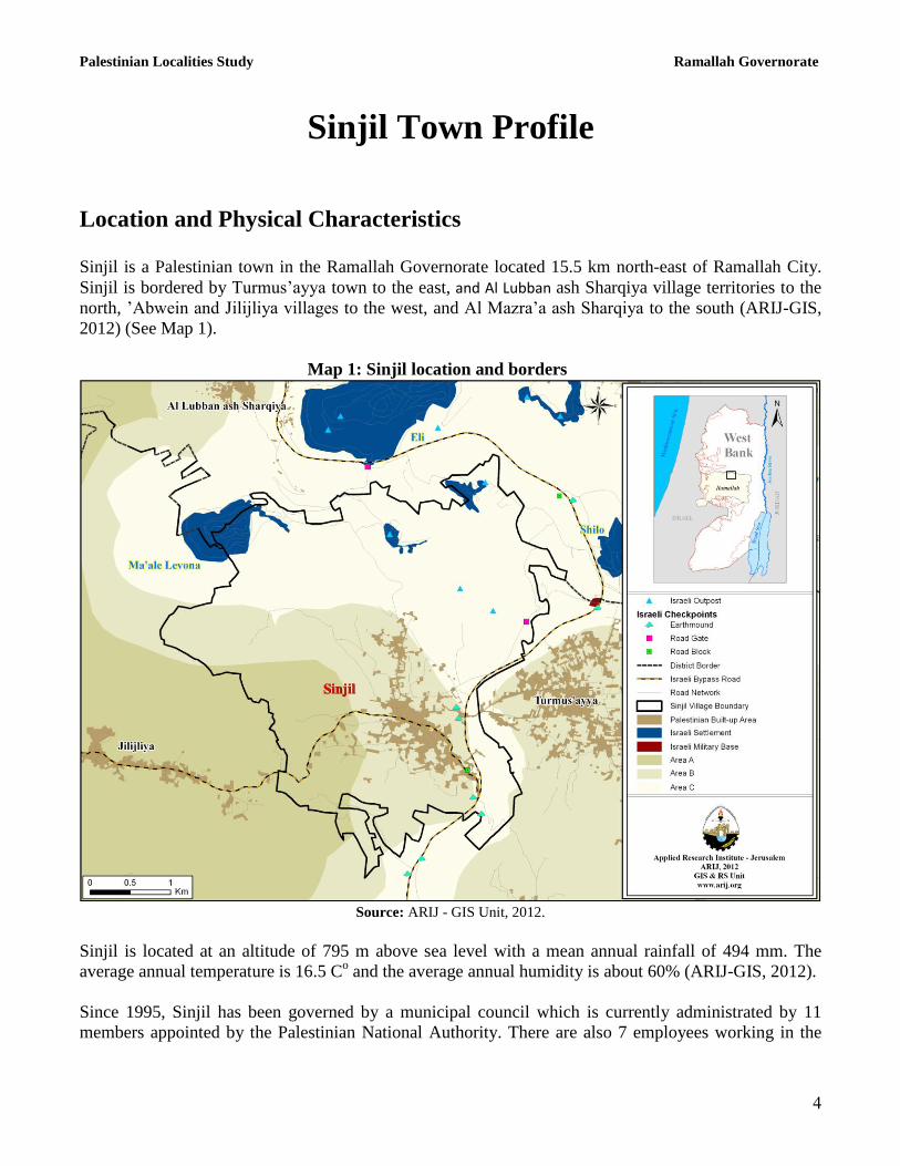
Sinjil is a Palestinian town in the Ramallah Governorate located 15.5 km north-east of Ramallah City.
Sinjil is bordered by Turmus‟ayya town to the east, and Al Lubban ash Sharqiya village territories to the
north, ‟Abwein and Jilijliya villages to the west, and Al Mazra‟a ash Sharqiya to the south (ARIJ-GIS,
2012) (See Map 1).
Map 1: Sinjil location and borders
Source: ARIJ - GIS Unit, 2012.
Sinjil is located at an altitude of 795 m above sea level with a mean annual rainfall of 494 mm. The
average annual temperature is 16.5 Co and the average annual humidity is about 60% (ARIJ-GIS, 2012).
Since 1995, Sinjil has been governed by a municipal council which is currently administrated by 11
members appointed by the Palestinian National Authority. There are also 7 employees working in the
Palestinian Localities Study Ramallah Governorate
5
Council, which owns a permanent headquarters and a vehicle for the collection of solid waste, in
addition to a mini-bus that serves residents of the town (Sinjil Municipal Council, 2010).
It is the responsibility of the municipal council to provide a number of services to the residents of Sinjil,
including (Sinjil Municipal Council, 2010):
1. Solid waste collection, road construction and restoration, street cleaning, and social development
services.
2. Organization of the construction and licensing processes.
3. Implementation of projects and studies for the town.
History
Sinjil took its name from the French commander Raymond de Saint-Gilles, Count of Toulouse. The
town was established 1105. Sinjil residents are descended from the Murra Tribe which emigrated from
the Arabian Peninsula to Palestine (Sinjil Municipal Council, 2010).
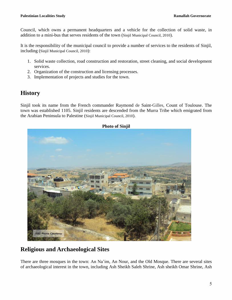
Photo of Sinjil
Religious and Archaeological Sites
There are three mosques in the town: An Na‟im, An Nour, and the Old Mosque. There are several sites
of archaeological interest in the town, including Ash Sheikh Saleh Shrine, Ash sheikh Omar Shrine, Ash
Palestinian Localities Study Ramallah Governorate
6
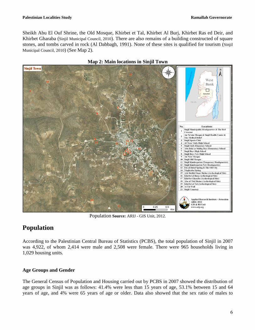
Sheikh Abu El Ouf Shrine, the Old Mosque, Khirbet et Tal, Khirbet Al Burj, Khirbet Ras ed Deir, and
Khirbet Gharaba (Sinjil Municipal Council, 2010). There are also remains of a building constructed of square
stones, and tombs carved in rock (Al Dabbagh, 1991). None of these sites is qualified for tourism (Sinjil
Municipal Council, 2010) (See Map 2).
Map 2: Main locations in Sinjil Town
Population Source: ARIJ - GIS Unit, 2012.
Population
According to the Palestinian Central Bureau of Statistics (PCBS), the total population of Sinjil in 2007
was 4,922, of whom 2,414 were male and 2,508 were female. There were 965 households living in
1,029 housing units.
Age Groups and Gender
The General Census of Population and Housing carried out by PCBS in 2007 showed the distribution of
age groups in Sinjil was as follows: 41.4% were less than 15 years of age, 53.1% between 15 and 64
years of age, and 4% were 65 years of age or older. Data also showed that the sex ratio of males to
Palestinian Localities Study Ramallah Governorate
7
females in the town is 96.3:100, meaning that males and females constitute 49% and 51% of the
population respectively.
Families
Sinjil residents are from several families, including the Shabaneh, Fuqaha‟, Masalmeh, Asfour, Khalil,
Elwan, Karakra, Tawafsha, „Awashra and Ghafri families (Sinjil Municipal Council, 2010).
Immigration
The field survey conducted by ARIJ staff shows that around 1000 persons have left the town since the
Al Aqsa Intifada in 2000 (Sinjil Municipal Council, 2010).
Education
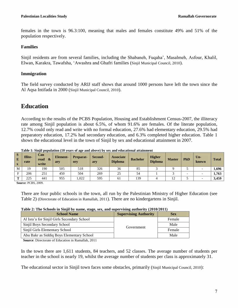
According to the results of the PCBS Population, Housing and Establishment Census-2007, the illiteracy
rate among Sinjil population is about 6.5%, of whom 91.6% are females. Of the literate population,
12.7% could only read and write with no formal education, 27.6% had elementary education, 29.5% had
preparatory education, 17.2% had secondary education, and 6.3% completed higher education. Table 1
shows the educational level in the town of Sinjil by sex and educational attainment in 2007.
Table 1: Sinjil population (10 years of age and above) by sex and educational attainment
S
E
x
Illite-
rate
Can
read &
write
Element-
ary
Preparat-
ory
Second-
ary
Associate
Diploma Bachelor
Higher
Diploma Master
PhD Un-
known Total
M 19 190 505 518 326 36 85 3 9 5 - 1,696
F 206 251 450 504 269 25 54 1 3 - - 1,763
T 225 441 955 1,022 595 61 139 4 12 5 - 3,459
Source: PCBS, 2009.
There are four public schools in the town, all run by the Palestinian Ministry of Higher Education (see
Table 2) (Directorate of Education in Ramallah, 2011). There are no kindergartens in Sinjil.
Table 2: The Schools in Sinjil by name, stage, sex, and supervising authority (2010/2011)
School Name Supervising Authority Sex
Al Isra‟a for Sinjil Girls Secondary School
Government
Female
Sinjil Boys Secondary School Male
Sinjil Girls Elementary School Female
Abu Bakr as Siddiq Boys Elementary School Male
Source: Directorate of Education in Ramallah, 2011
In the town there are 1,611 students, 84 teachers, and 52 classes. The average number of students per
teacher in the school is nearly 19, whilst the average number of students per class is approximately 31.
The educational sector in Sinjil town faces some obstacles, primarily (Sinjil Municipal Council, 2010):
Palestinian Localities Study Ramallah Governorate
8
Insufficient number of classrooms.
Lack of playgrounds and yards in schools.
School buildings are in need of renovation.
Schools are not equipped to provide for those with special needs.
There are no means of transportation for children and students with special needs.
Health Status
Sinjil town has a medical center sponsored by the Palestinian Medical Relief Society (PMRS) and a
private pharmacy. The town also has an ambulance owned by the Red Crescent Society. In the absence
of required health services or in emergencies, patients are transferred to Ramallah Governmental
Hospital, 40 km from the village (Sinjil Municipal Council, 2010).
The health sector in the town experiences some obstacles and problems, including (Sinjil Municipal Council,
2010):
There is no center to carry out X-ray examinations.
There are no physicians to work night shifts.
There is no ambulance operating on a night shift.
Economic Activities
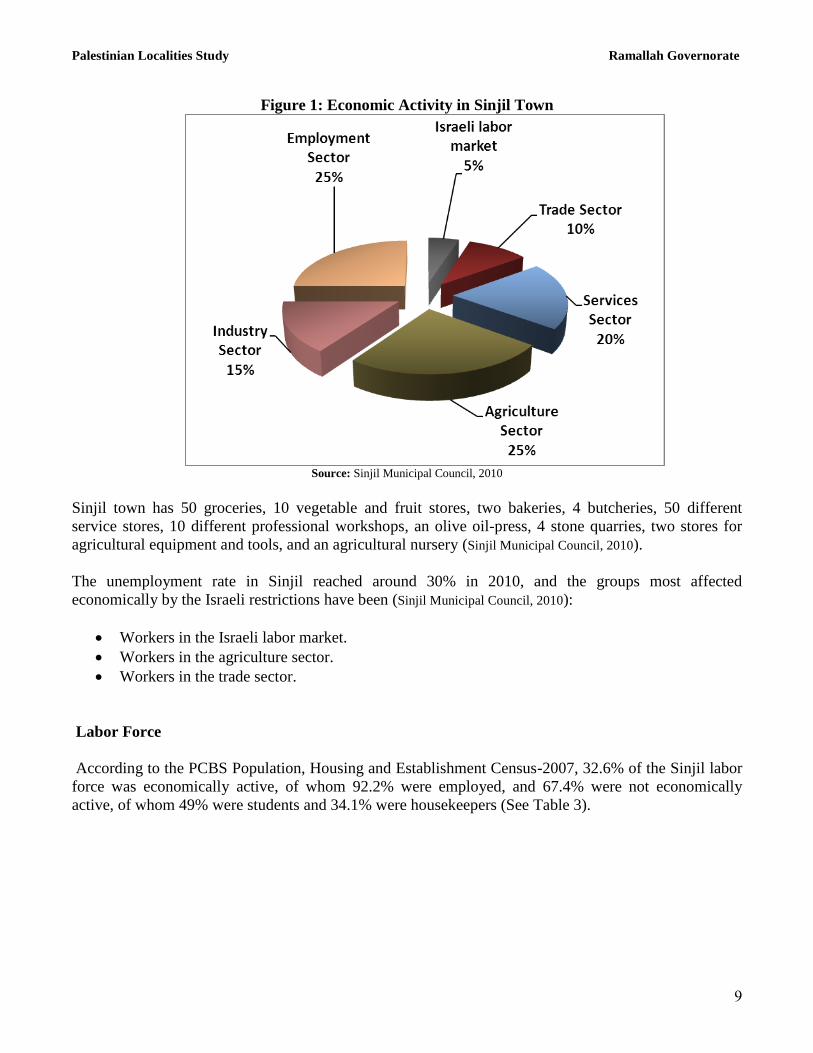
The economy in Sinjil is dependent on several economic sectors, mainly the agricultural and
employment sectors, which each absorb 25% of the town workforce (Sinjil Municipal Council, 2010) (See
Figure1).
The results of a field survey conducted by the ARIJ team in 2010 for the distribution of labor by
economic activity in Sinjil are as follows (Sinjil Municipal Council, 2010):
Government or Private Employees Sector (25%)
Agriculture Sector (25%)
Services Sector (20%)
Industry (15%)
Trade Sector (10%)
Israeli Labor Market (5%)
Palestinian Localities Study Ramallah Governorate
9
Figure 1: Economic Activity in Sinjil Town
Source: Sinjil Municipal Council, 2010
Sinjil town has 50 groceries, 10 vegetable and fruit stores, two bakeries, 4 butcheries, 50 different
service stores, 10 different professional workshops, an olive oil-press, 4 stone quarries, two stores for
agricultural equipment and tools, and an agricultural nursery (Sinjil Municipal Council, 2010).
The unemployment rate in Sinjil reached around 30% in 2010, and the groups most affected
economically by the Israeli restrictions have been (Sinjil Municipal Council, 2010):
Workers in the Israeli labor market.
Workers in the agriculture sector.
Workers in the trade sector.
Labor Force
According to the PCBS Population, Housing and Establishment Census-2007, 32.6% of the Sinjil labor
force was economically active, of whom 92.2% were employed, and 67.4% were not economically
active, of whom 49% were students and 34.1% were housekeepers (See Table 3).
Palestinian Localities Study Ramallah Governorate
11
Table 3: Sinjil population (10 years of age and above) by sex and employment status
S
e
x
Economically active Non-economically active
Not
stated Total
Employed
Currently
Unem-
ployed
Un-
employed
(never
worked)
Total Student House-
keeping
Unable
to work
Not
working
& not
looking
for work
Others Total
M 931 60 24 1,015 557 - 76 21 27 681 - 1,696
F 110 3 1 114 584 795 156 7 102 1,649 - 1,763
T 1,041 63 25 1,129 1,141 795 232 28 134 2,330 - 3,459 M: Male; F: Female; T: Total.
Source: PCBS, 2009.
Agricultural Sector
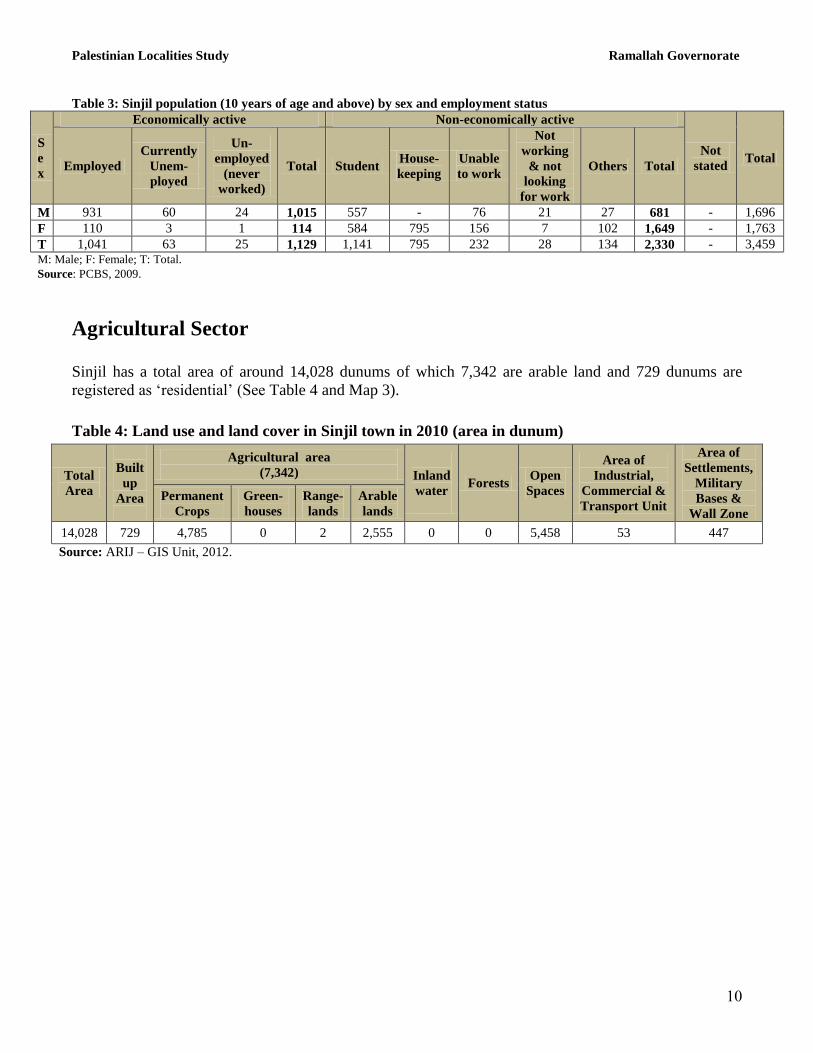
Sinjil has a total area of around 14,028 dunums of which 7,342 are arable land and 729 dunums are
registered as „residential‟ (See Table 4 and Map 3).
Table 4: Land use and land cover in Sinjil town in 2010 (area in dunum)
Total
Area
Built
up
Area
Agricultural area
(7,342)
Inland
water
Forests Open
Spaces
Area of
Industrial,
Commercial &
Transport Unit
Area of
Settlements,
Military
Bases &
Wall Zone
Permanent
Crops
Green-
houses
Range-
lands
Arable
lands
14,028 729 4,785 0 2 2,555 0 0 5,458 53 447
Source: ARIJ – GIS Unit, 2012.
Palestinian Localities Study Ramallah Governorate
11
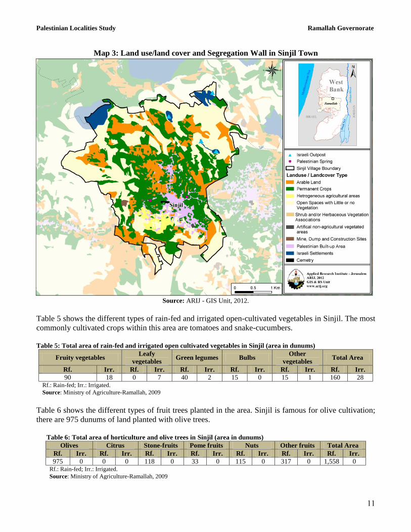
Map 3: Land use/land cover and Segregation Wall in Sinjil Town
Source: ARIJ - GIS Unit, 2012.
Table 5 shows the different types of rain-fed and irrigated open-cultivated vegetables in Sinjil. The most
commonly cultivated crops within this area are tomatoes and snake-cucumbers.
Table 5: Total area of rain-fed and irrigated open cultivated vegetables in Sinjil (area in dunums)
Fruity vegetables Leafy
vegetables Green legumes Bulbs
Other
vegetables Total Area
Rf. Irr. Rf. Irr. Rf. Irr. Rf. Irr. Rf. Irr. Rf. Irr.
90 18 0 7 40 2 15 0 15 1 160 28 Rf.: Rain-fed; Irr.: Irrigated.
Source: Ministry of Agriculture-Ramallah, 2009
Table 6 shows the different types of fruit trees planted in the area. Sinjil is famous for olive cultivation;
there are 975 dunums of land planted with olive trees.
Table 6: Total area of horticulture and olive trees in Sinjil (area in dunums)
Olives Citrus Stone-fruits Pome fruits Nuts Other fruits Total Area
Rf. Irr. Rf. Irr. Rf. Irr. Rf. Irr. Rf. Irr. Rf. Irr. Rf. Irr.
975 0 0 0 118 0 33 0 115 0 317 0 1,558 0 Rf.: Rain-fed; Irr.: Irrigated.
Source: Ministry of Agriculture-Ramallah, 2009
Palestinian Localities Study Ramallah Governorate
12
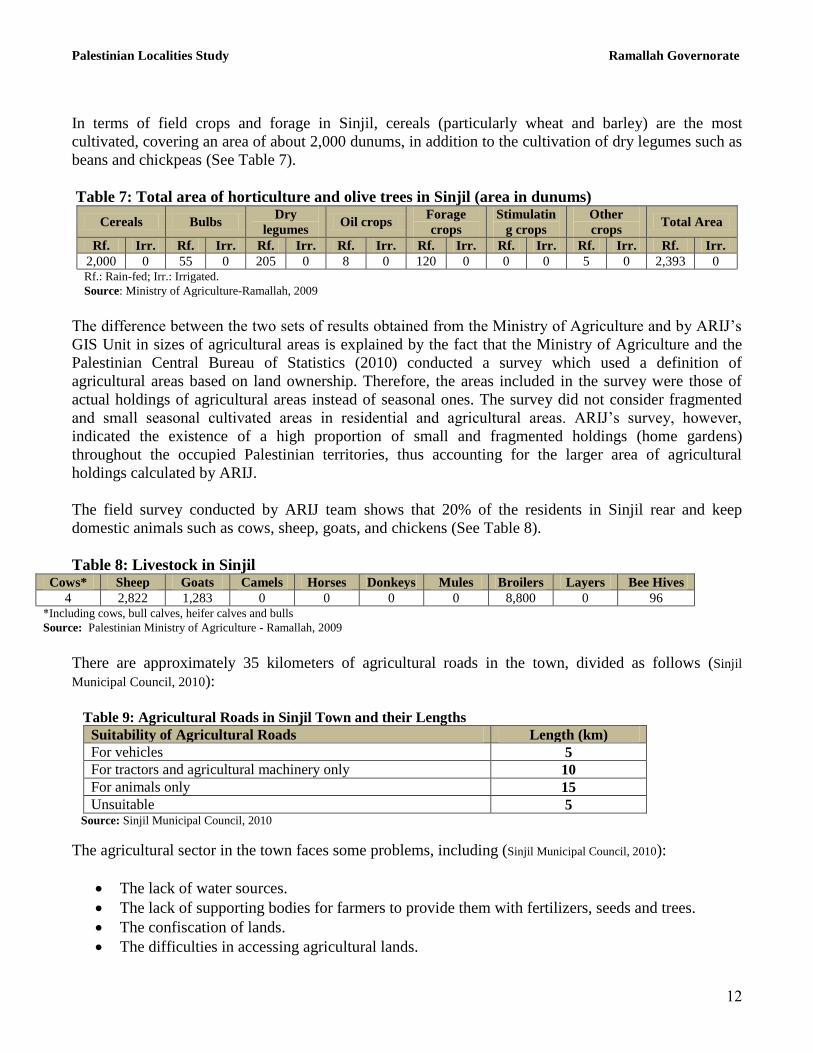
In terms of field crops and forage in Sinjil, cereals (particularly wheat and barley) are the most
cultivated, covering an area of about 2,000 dunums, in addition to the cultivation of dry legumes such as
beans and chickpeas (See Table 7).
Table 7: Total area of horticulture and olive trees in Sinjil (area in dunums)
Cereals Bulbs Dry
legumes Oil crops
Forage
crops
Stimulatin
g crops
Other
crops Total Area
Rf. Irr. Rf. Irr. Rf. Irr. Rf. Irr. Rf. Irr. Rf. Irr. Rf. Irr. Rf. Irr.
2,000 0 55 0 205 0 8 0 120 0 0 0 5 0 2,393 0 Rf.: Rain-fed; Irr.: Irrigated.
Source: Ministry of Agriculture-Ramallah, 2009
The difference between the two sets of results obtained from the Ministry of Agriculture and by ARIJ‟s
GIS Unit in sizes of agricultural areas is explained by the fact that the Ministry of Agriculture and the
Palestinian Central Bureau of Statistics (2010) conducted a survey which used a definition of
agricultural areas based on land ownership. Therefore, the areas included in the survey were those of
actual holdings of agricultural areas instead of seasonal ones. The survey did not consider fragmented
and small seasonal cultivated areas in residential and agricultural areas. ARIJ‟s survey, however,
indicated the existence of a high proportion of small and fragmented holdings (home gardens)
throughout the occupied Palestinian territories, thus accounting for the larger area of agricultural
holdings calculated by ARIJ.
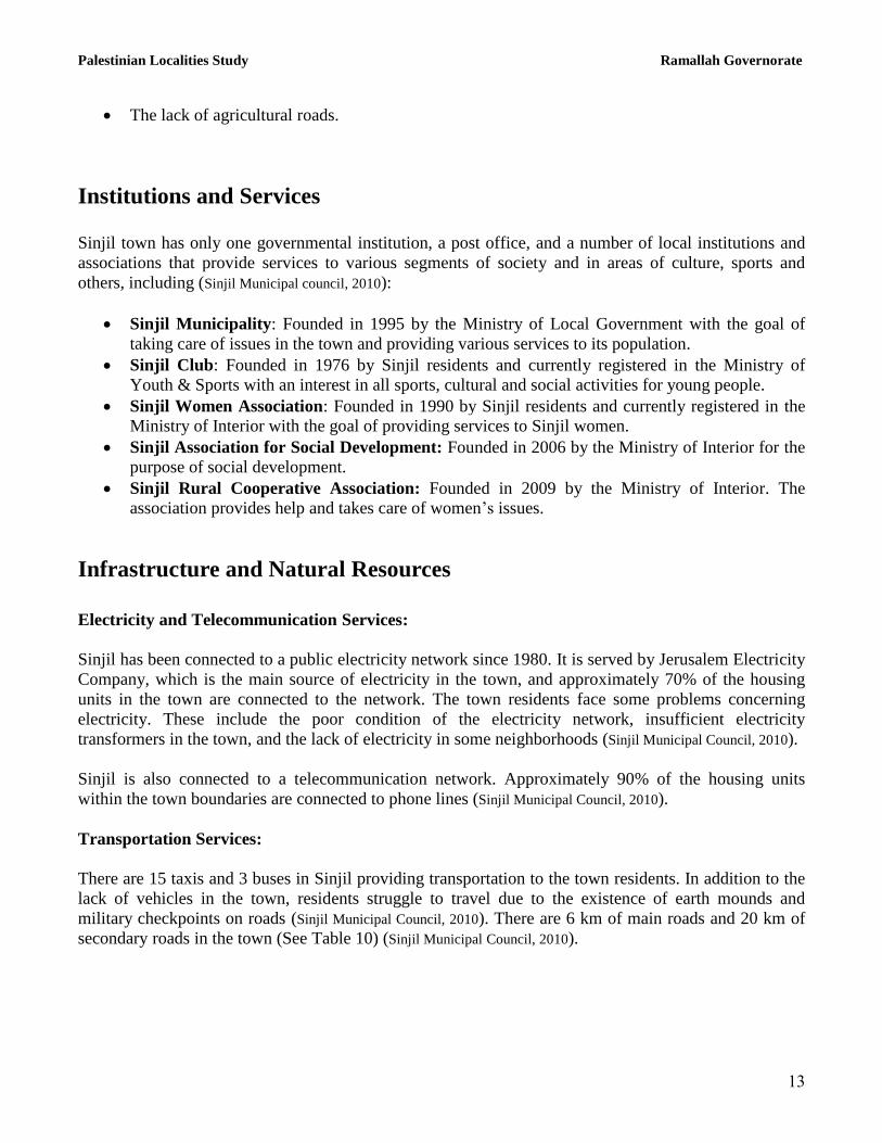
The field survey conducted by ARIJ team shows that 20% of the residents in Sinjil rear and keep
domestic animals such as cows, sheep, goats, and chickens (See Table 8).
Table 8: Livestock in Sinjil Cows* Sheep Goats Camels Horses Donkeys Mules Broilers Layers Bee Hives
4 2,822 1,283 0 0 0 0 8,800 0 96 *Including cows, bull calves, heifer calves and bulls
Source: Palestinian Ministry of Agriculture - Ramallah, 2009
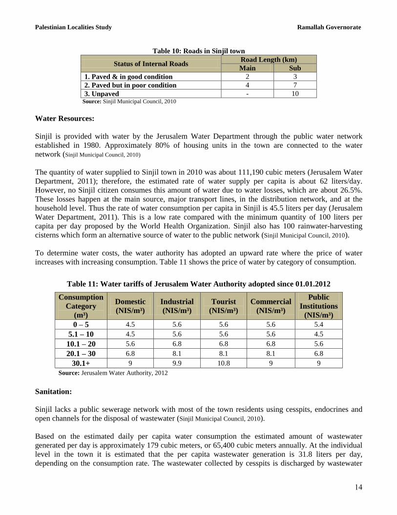
There are approximately 35 kilometers of agricultural roads in the town, divided as follows (Sinjil
Municipal Council, 2010):
Table 9: Agricultural Roads in Sinjil Town and their Lengths
Suitability of Agricultural Roads Length (km)
For vehicles 5
For tractors and agricultural machinery only 10
For animals only 15
Unsuitable 5 Source: Sinjil Municipal Council, 2010
The agricultural sector in the town faces some problems, including (Sinjil Municipal Council, 2010):
The lack of water sources.
The lack of supporting bodies for farmers to provide them with fertilizers, seeds and trees.
The confiscation of lands.
The difficulties in accessing agricultural lands.
Palestinian Localities Study Ramallah Governorate
13
The lack of agricultural roads.
Institutions and Services
Sinjil town has only one governmental institution, a post office, and a number of local institutions and
associations that provide services to various segments of society and in areas of culture, sports and
others, including (Sinjil Municipal council, 2010):
Sinjil Municipality: Founded in 1995 by the Ministry of Local Government with the goal of
taking care of issues in the town and providing various services to its population.
Sinjil Club: Founded in 1976 by Sinjil residents and currently registered in the Ministry of
Youth & Sports with an interest in all sports, cultural and social activities for young people.
Sinjil Women Association: Founded in 1990 by Sinjil residents and currently registered in the
Ministry of Interior with the goal of providing services to Sinjil women.
Sinjil Association for Social Development: Founded in 2006 by the Ministry of Interior for the
purpose of social development.
Sinjil Rural Cooperative Association: Founded in 2009 by the Ministry of Interior. The
association provides help and takes care of women‟s issues.
Infrastructure and Natural Resources
Electricity and Telecommunication Services:
Sinjil has been connected to a public electricity network since 1980. It is served by Jerusalem Electricity
Company, which is the main source of electricity in the town, and approximately 70% of the housing
units in the town are connected to the network. The town residents face some problems concerning
electricity. These include the poor condition of the electricity network, insufficient electricity
transformers in the town, and the lack of electricity in some neighborhoods (Sinjil Municipal Council, 2010).
Sinjil is also connected to a telecommunication network. Approximately 90% of the housing units
within the town boundaries are connected to phone lines (Sinjil Municipal Council, 2010).
Transportation Services:
There are 15 taxis and 3 buses in Sinjil providing transportation to the town residents. In addition to the
lack of vehicles in the town, residents struggle to travel due to the existence of earth mounds and
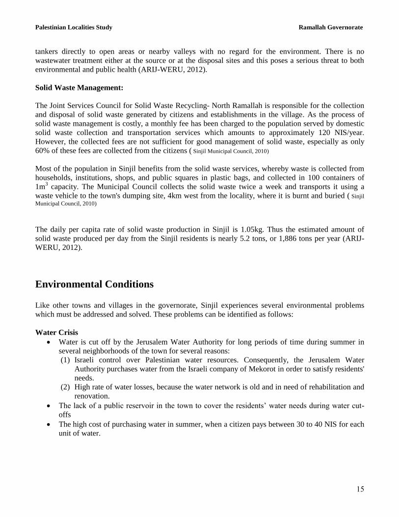
military checkpoints on roads (Sinjil Municipal Council, 2010). There are 6 km of main roads and 20 km of
secondary roads in the town (See Table 10) (Sinjil Municipal Council, 2010).
Palestinian Localities Study Ramallah Governorate
14
Table 10: Roads in Sinjil town
Status of Internal Roads Road Length (km)
Main Sub
1. Paved & in good condition 2 3
2. Paved but in poor condition 4 7
3. Unpaved - 10 Source: Sinjil Municipal Council, 2010
Water Resources:
Sinjil is provided with water by the Jerusalem Water Department through the public water network
established in 1980. Approximately 80% of housing units in the town are connected to the water
network (Sinjil Municipal Council, 2010)
The quantity of water supplied to Sinjil town in 2010 was about 111,190 cubic meters (Jerusalem Water
Department, 2011); therefore, the estimated rate of water supply per capita is about 62 liters/day.
However, no Sinjil citizen consumes this amount of water due to water losses, which are about 26.5%.
These losses happen at the main source, major transport lines, in the distribution network, and at the
household level. Thus the rate of water consumption per capita in Sinjil is 45.5 liters per day (Jerusalem
Water Department, 2011). This is a low rate compared with the minimum quantity of 100 liters per
capita per day proposed by the World Health Organization. Sinjil also has 100 rainwater-harvesting
cisterns which form an alternative source of water to the public network (Sinjil Municipal Council, 2010).
To determine water costs, the water authority has adopted an upward rate where the price of water
increases with increasing consumption. Table 11 shows the price of water by category of consumption.
Table 11: Water tariffs of Jerusalem Water Authority adopted since 01.01.2012
Consumption
Category
(m³)
Domestic
(NIS/m³)
Industrial
(NIS/m³)
Tourist
(NIS/m³)
Commercial
(NIS/m³)
Public
Institutions
(NIS/m³)
0 – 5 4.5 5.6 5.6 5.6 5.4
5.1 – 10 4.5 5.6 5.6 5.6 4.5
10.1 – 20 5.6 6.8 6.8 6.8 5.6
20.1 – 30 6.8 8.1 8.1 8.1 6.8
30.1+ 9 9.9 10.8 9 9
Source: Jerusalem Water Authority, 2012
Sanitation:
Sinjil lacks a public sewerage network with most of the town residents using cesspits, endocrines and
open channels for the disposal of wastewater (Sinjil Municipal Council, 2010).
Based on the estimated daily per capita water consumption the estimated amount of wastewater
generated per day is approximately 179 cubic meters, or 65,400 cubic meters annually. At the individual
level in the town it is estimated that the per capita wastewater generation is 31.8 liters per day,
depending on the consumption rate. The wastewater collected by cesspits is discharged by wastewater
Palestinian Localities Study Ramallah Governorate
15
tankers directly to open areas or nearby valleys with no regard for the environment. There is no
wastewater treatment either at the source or at the disposal sites and this poses a serious threat to both
environmental and public health (ARIJ-WERU, 2012).
Solid Waste Management:
The Joint Services Council for Solid Waste Recycling- North Ramallah is responsible for the collection
and disposal of solid waste generated by citizens and establishments in the village. As the process of
solid waste management is costly, a monthly fee has been charged to the population served by domestic
solid waste collection and transportation services which amounts to approximately 120 NIS/year.
However, the collected fees are not sufficient for good management of solid waste, especially as only
60% of these fees are collected from the citizens ( Sinjil Municipal Council, 2010)
Most of the population in Sinjil benefits from the solid waste services, whereby waste is collected from
households, institutions, shops, and public squares in plastic bags, and collected in 100 containers of
1m3 capacity. The Municipal Council collects the solid waste twice a week and transports it using a
waste vehicle to the town's dumping site, 4km west from the locality, where it is burnt and buried ( Sinjil
Municipal Council, 2010)
The daily per capita rate of solid waste production in Sinjil is 1.05kg. Thus the estimated amount of
solid waste produced per day from the Sinjil residents is nearly 5.2 tons, or 1,886 tons per year (ARIJ-
WERU, 2012).
Environmental Conditions
Like other towns and villages in the governorate, Sinjil experiences several environmental problems
which must be addressed and solved. These problems can be identified as follows:
Water Crisis
Water is cut off by the Jerusalem Water Authority for long periods of time during summer in
several neighborhoods of the town for several reasons:
(1) Israeli control over Palestinian water resources. Consequently, the Jerusalem Water
Authority purchases water from the Israeli company of Mekorot in order to satisfy residents'
needs.
(2) High rate of water losses, because the water network is old and in need of rehabilitation and
renovation.
The lack of a public reservoir in the town to cover the residents‟ water needs during water cut-
offs
The high cost of purchasing water in summer, when a citizen pays between 30 to 40 NIS for each
unit of water.
Palestinian Localities Study Ramallah Governorate
16
Wastewater Management
The absence of a public sewage network means that Sinjil residents are forced to use unhygienic
cesspits for the disposal of wastewater, and/or to discharge wastewater in the streets. This is
particularly common in winter, as citizens cannot afford the high cost of sewage tankers during
this period. These methods facilitate environmental damage, health problems, and the spread of
epidemics and diseases in the town. This wastewater also contaminates the groundwater because
most cesspits are built without lining, allowing wastewater to enter into the ground and avoiding
the need to use sewage tankers. Moreover, the untreated wastewater collected from cesspits by
sewage tankers is disposed of in open areas without concern for the damage it causes to the
environment and to residents' health.
Solid Waste Management:
The lack of a central sanitary landfill to serve Sinjil and the other neighboring communities in
the governorate is due mainly to the obstacles created by the Israeli authorities for local and
national institutions in granting licenses to establish such a landfill, because the appropriate land
is within Area C and under Israeli control. Additionally, the implementation of such projects
depends on funding from donor countries. The lack of a sanitary landfill is a source of pollution
to the groundwater and soil through the leachate produced from the solid waste, and produces
bad odors and distortion of the landscape.
Impact of the Israeli Occupation
Geopolitical status in Sinjil
According to the Oslo II Interim Agreement signed in 28th
September 1995 between the Palestinian
Liberation Organization (PLO) and Israel, Sinjil was divided into areas “A”, “B” and “C”.
Approximately 1,944 dunams (13.8% of the town‟s total area) were assigned as area A where the
Palestinian National Authority (PNA) holds all responsibilities for internal security and Public order,
while 4,865 dunams (34.7% of the town‟s total area) were classified as area B, where the PNA has
complete control over civil matters but Israel continues to have overriding responsibility for security.
Area B constitutes most of the inhabited Palestinian areas, including municipalities, villages and some
camps. It is worth mentioning that most of the town‟s population resides in area B. The rest of the
town‟s area, constituting 7,219 dunams (51.5% of the total area), was classified as area C, where Israel
retains full control over security and administration related to the territory. In area C Palestinian building
and land management is prohibited unless through a consent or authorization by the Israeli Civil
Administration. Most of the lands lying within area C are agricultural areas and open spaces (table 12).

Palestinian Localities Study Ramallah Governorate
17
Table 12: The Geopolitical Divisions of Sinjil – Ramallah Governorate
Percent of Total town
area Area in dunams Area
13.8 1,944 Area A
34.7 4,865 Area B
51.5 7,219 Area C
0 0 Nature Reserve
100 14,028 Total
Source: Source: ARIJ-GIS, 2011
Sinjil Town and the Israeli Occupation Practices
Sinjil town has been subjected its share of Israeli confiscations for the benefit of various Israeli
interests, represented in the construction of Israeli settlements, outposts and military checkpoints, as well
as the construction of the Israeli bypass roads to connect the Israeli settlements. Following is a
breakdown of the Israeli confiscations of Sinjil town territories:
During the Israeli Occupation of the Palestinian territory, the Israeli government confiscated 447
dunams in Sinjil town to establish the Ma'ale Levona settlement which was constructed on Sinjil‟s land
along with the land of 2 nearby villages Al Lubban ash Sharqiya and „Abwein. The settlement was
constructed in 1983 on a total area of land of 521 dunams and is currently inhabited by 713 Israeli
settlers.
Attacks carried out by Israeli settlers living in the illegal settlements around Sinjil have had a serious
and significant impact on the town people and their properties. These attacks allow settlers to control
more Palestinian lands adjacent to the settlements by preventing landowners from accessing their land.
Settlers near Sinjil have enclosed land using barbed wire and planted trees on Palestinian land, thereby
increasing their control. They have also burnt and uprooted trees planted and owned by Palestinians and
attacked landowners as to intimidate and deter them from returning to their lands. In the early morning
hours of June 22, 2011, the last attack took place: a group of settlers living in Shvut Rahel settlement
cut 51 olive trees aged 34 years using sharp saws. The targeted trees belong to three Palestinian families
in Sinjil town. It should be noted that the targeted trees in Ad Dahra area were previously targeted on 2
separate occasions by the same settlers from the Shvut Rahel settlement; once in 2000 and again in
2004.
The Israeli Government confiscated thousands of agricultural and non-agricultural lands to open several
bypass roads that stretch thousands of kilometers from the north to the south of the West Bank, to link
Israeli settlements with each others, dismembering Palestinian lands and enhancing security control over
it. Israel has also confiscated more land from Sinjil and to its north and east for the construction of the
Israeli bypass road no. 60 as well as the road leading to the Ma'ale Levona Israeli settlement. This road
is under Israeli control and appropriates the old road linked to Nablus city through Al Lubban ash
Sharqiya. The total length of these two roads lying within Sinjil lands is 6.5 km. The real threat of
bypass roads lies in the buffer zone formed by the Israeli Occupation Force (IOF) along these roads,
extending approximately 75 m on each side. These buffer zones dramatically increase the total area of
land affected by the construction of the bypass roads.
Palestinian Localities Study Ramallah Governorate
18
Following the outbreak of the second Palestinian Intifada in September 2000, the IOF constructed a
military checkpoint (an earth mound) on Sinjil‟s main eastern entrance in order to prevent Palestinians
from approaching bypass road no. 60. This entrance is closed to this day; thus residents use the northern
entrance instead. Also, the Israeli authorities established another 3 earth mounds and a roadblock on
some of the town‟s sub-entrances on bypass road 60. Moreover, they established an iron gate on the
agricultural road between Sinjil and Turmus‟ayya to prevent farmers from accessing their lands. These
military checkpoints aim at restricting the movement of the town population; in particular and the
neighboring villages. These restrictions had notable effects during the first and second Palestinian
Intifadas, as well as the intent of the occupation to protect the settlers near the town who travel through
the Israeli bypass road 60.
In an attempt to expand the nearby Israeli settlements (mainly Eli settlement north of Sinjil), land from
Sinjil has been forcefully seized by Israeli settlers to build 4 Israeli outposts: South Eli, Eli South (Hill
792), Eli South/Apiryon Hill and Givat Harel. This affords more control of Palestinian land to Israel.
It should be known that on August 4th
, 2012, the Israeli occupation authorities started to establish and set
up a number of new mobile homes in the vicinity of the Israeli occupation army camp that was
established near Sinjil town in 2002. The total land area used was an estimated 20 dunams. It should be
noted that in the past few months, settlers began to strengthen their control on the camp by adding more
mobile homes and erecting a number of tents in the camp vicinity, in a move to turn the camp into a new
Israeli settlement devouring vast areas of land planted with olives in Ras ad Deir area east of Sinjil town.
During the last two decades, Israel has built 232 outposts in the West Bank. These outposts are
considered the nucleus for the development of new settlements. Outposts are composed of mobile
caravans that are located on land stolen by the settlers and they are a branch of a nearby mother
settlement. One might add that the epidemic of Israeli outposts started with a “Sharonian” call for
Jewish settlers to take control of Palestinian hilltops to prevent transferring them to Palestinians in
negotiations. Although the successive Israeli governments haven‟t legalized this phenomenon, they
managed to find security and logistical cover to justify the act, its existence and continuity. After 2001
the Prime Minister at that time, Ariel Sharon, unleashed the expansion of outposts which has led to a
significant increase in the number of outposts within Palestinian areas. Also, the IOF helped the Israeli
settlers move and settle in those outposts, as well as protecting and providing them with the necessary
infrastructure to guarantee their continued existence.
Issued Military Orders in Sinjil Town
The Israeli Occupation Army has issued many military orders to confiscate lands in Sinjil. Following are
some of the available orders:
Israeli Military Order No. (01/01/T): Issued on the 21st
of February 2001. It confiscates lands
north of Sinjil town and on the old road to Al Lubban ash Sharqiya, for military purposes.
Israeli Military Order No. (09/06/T): Issued on the 17th
of January 2006. It confiscates a total
land area of 1.88 dunams of land from Sinjil and Turmus‟ayya towns for military purposes and
to protect the bypass road.
Palestinian Localities Study Ramallah Governorate
19
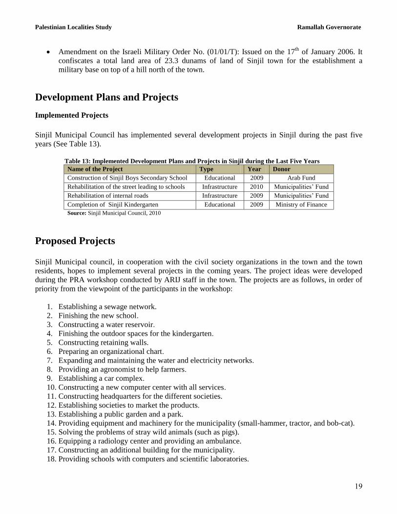
Amendment on the Israeli Military Order No. (01/01/T): Issued on the 17th
of January 2006. It
confiscates a total land area of 23.3 dunams of land of Sinjil town for the establishment a
military base on top of a hill north of the town.
Development Plans and Projects
Implemented Projects
Sinjil Municipal Council has implemented several development projects in Sinjil during the past five
years (See Table 13).
Table 13: Implemented Development Plans and Projects in Sinjil during the Last Five Years
Name of the Project Type Year Donor
Construction of Sinjil Boys Secondary School Educational 2009 Arab Fund
Rehabilitation of the street leading to schools Infrastructure 2010 Municipalities‟ Fund
Rehabilitation of internal roads Infrastructure 2009 Municipalities‟ Fund
Completion of Sinjil Kindergarten Educational 2009 Ministry of Finance
Source: Sinjil Municipal Council, 2010
Proposed Projects
Sinjil Municipal council, in cooperation with the civil society organizations in the town and the town
residents, hopes to implement several projects in the coming years. The project ideas were developed
during the PRA workshop conducted by ARIJ staff in the town. The projects are as follows, in order of
priority from the viewpoint of the participants in the workshop:
1. Establishing a sewage network.
2. Finishing the new school.
3. Constructing a water reservoir.
4. Finishing the outdoor spaces for the kindergarten.
5. Constructing retaining walls.
6. Preparing an organizational chart.
7. Expanding and maintaining the water and electricity networks.
8. Providing an agronomist to help farmers.
9. Establishing a car complex.
10. Constructing a new computer center with all services.
11. Constructing headquarters for the different societies.
12. Establishing societies to market the products.
13. Establishing a public garden and a park.
14. Providing equipment and machinery for the municipality (small-hammer, tractor, and bob-cat).
15. Solving the problems of stray wild animals (such as pigs).
16. Equipping a radiology center and providing an ambulance.
17. Constructing an additional building for the municipality.
18. Providing schools with computers and scientific laboratories.
Palestinian Localities Study Ramallah Governorate
21
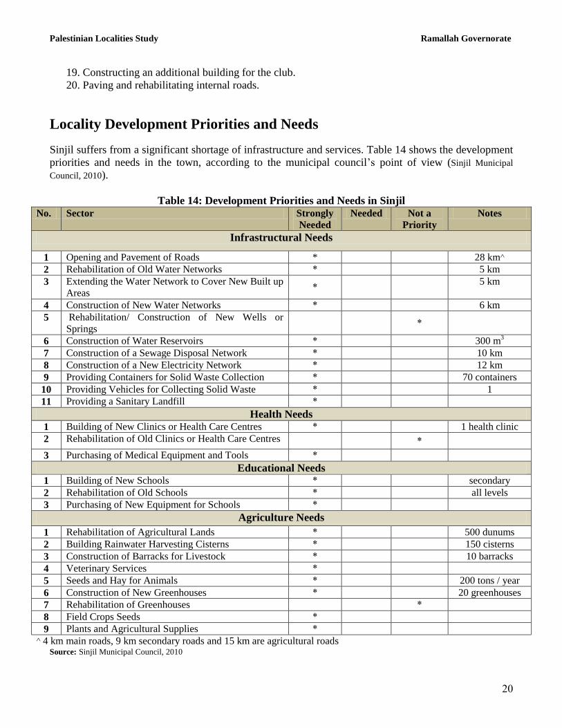
19. Constructing an additional building for the club.
20. Paving and rehabilitating internal roads.
Locality Development Priorities and Needs
Sinjil suffers from a significant shortage of infrastructure and services. Table 14 shows the development
priorities and needs in the town, according to the municipal council‟s point of view (Sinjil Municipal
Council, 2010).
Table 14: Development Priorities and Needs in Sinjil
No. Sector Strongly
Needed
Needed Not a
Priority
Notes
Infrastructural Needs
1 Opening and Pavement of Roads * 28 km^
2 Rehabilitation of Old Water Networks * 5 km
3 Extending the Water Network to Cover New Built up
Areas *
5 km
4 Construction of New Water Networks * 6 km
5 Rehabilitation/ Construction of New Wells or
Springs *
6 Construction of Water Reservoirs * 300 m3
7 Construction of a Sewage Disposal Network * 10 km
8 Construction of a New Electricity Network * 12 km
9 Providing Containers for Solid Waste Collection * 70 containers
10 Providing Vehicles for Collecting Solid Waste * 1
11 Providing a Sanitary Landfill *
Health Needs 1 Building of New Clinics or Health Care Centres * 1 health clinic
2 Rehabilitation of Old Clinics or Health Care Centres *
3 Purchasing of Medical Equipment and Tools *
Educational Needs 1 Building of New Schools * secondary
2 Rehabilitation of Old Schools * all levels
3 Purchasing of New Equipment for Schools *
Agriculture Needs
1 Rehabilitation of Agricultural Lands * 500 dunums
2 Building Rainwater Harvesting Cisterns * 150 cisterns
3 Construction of Barracks for Livestock * 10 barracks
4 Veterinary Services *
5 Seeds and Hay for Animals * 200 tons / year
6 Construction of New Greenhouses * 20 greenhouses
7 Rehabilitation of Greenhouses *
8 Field Crops Seeds *
9 Plants and Agricultural Supplies *
^ 4 km main roads, 9 km secondary roads and 15 km are agricultural roads Source: Sinjil Municipal Council, 2010
Palestinian Localities Study Ramallah Governorate
21
References:
Al Dabbagh, M. Our Country, Palestine; Chapter 8, Part Two. Kafr Qari' – Palestine. Dar al Huda
Press, 1991.
Applied Research Institute - Jerusalem (ARIJ), 2012. Geographic Information Systems and
Remote Sensing Unit Database. Bethlehem - Palestine.
Applied Research Institute - Jerusalem (ARIJ), 2012. Geographic Information Systems and Remote
Sensing Unit; Land Use Analysis (2010) – Half Meter High Accuracy. Bethlehem - Palestine.
Applied Research Institute - Jerusalem (ARIJ). 2012. Water & Environment Research Unit
Database (WERU). Bethlehem - Palestine.
Jerusalem Water Authority (for Ramallah & Al Bireh areas) (2011). Detection showing the amount
of water sold from 1/1/2010 till 31/12/2010. Ramallah – Palestine.
Jerusalem Water Authority (2012). Jerusalem Water Authority's Website; Data Retrieved on the
first of March. http://www.jwu.org/newweb/atemplate.php?id=87.
Ministry of Education & Higher Education (MOHE) - Ramallah, 2011. Directorate of Education;
A database of schools (2010/2011). Ramallah – Palestine.
Palestinian Central Bureau of Statistics. 2009. Ramallah, Palestine: General Census of Population
and Housing Censuses, 2007.
Palestinian Ministry of Agriculture (MOA), 2009. Directorate of Agriculture data (2008/2009).
Ramallah - Palestine.
Sinjil Municipal Council, 2011.