simplified photogrammetrical documentation and ... filesimplified photogrammetrical documentation...
TRANSCRIPT
SIMPLIFIED PHOTOGRAMMETRICAL DOCUMENTATION AND
VISUALIZATION OF HISTORIC OBJECTS IN PERU
Karolína Hanzalová, Zdeněk Čumpelík, Soňa Mathauserová, Pavel Filípek, Miroslav
Odvody, Radim Kostka
Czech Technical University in Prague, Faculty of Civil Engineering
Thákurova 7, Prague 6, Czech Republic
Keywords: Photogrammetry, PhotoModeler, visualization, Google SketchUp, Microstation
Abstract: This paper deals with the possibilities of creating a 3D model and visualization technique for
presentation of three-dimensional objects in Peru. The project Nazca/Peru documents several historic
objects. This paper discusses documentation and visualization of five of them: The Church in San Jose, San
Xavier Church, Santa Ana Church, Hacienda de La Pena and archeological site Sechín. All objects are
damaged by earthquake. Some have been repaired; some are on the list of company World Monuments
Fund, a company which receives funds for the repair of major historic monuments. Processing
documentation of these objects is different. Level first, PhotoModeler software was used for
photogrammetric data processing of acquired images. The principle of PhotoModeler is based on the
intersection photogrammetry method. It combines images and coordinates of points in tree-dimensional
space. It can create 3D models and export in another software. Another possibility of creating a 3D model is
CADs software Microstation, which was used for the model of San Xavier Church as well as a 3D model of
the Santa Ana Church. The same procedure was chosen for creating a 3D model of Hacienda de La Pena.
Documentation of archeological site Sechín was created the photomaps of enclosure wall. The wall is thanks
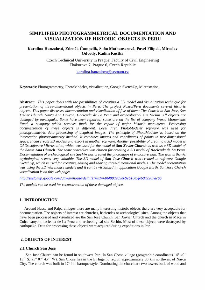
mythological scenes very valuable. The 3D model of San Jose Church was created in software Google
SketchUp, which is used for creating, editing and sharing three-dimensional models. The model presentation
was using the 3D Warehouse models and it can be visualized in application Google Earth. San Jose Church
visualization is on this web page:
http://sketchup.google.com/3dwarehouse/details?mid=686f08d983d09eb18d5fe60d2287ac66
The models can be used for reconstruction of these damaged objects.
1. INTRODUCTION
Around Nasca and Palpa villages there are many interesting historic objects there are very acceptable for
documentation. The objects of interest are churches, haciendas or archeological sites. Among the objects that
have been processed and visualized are the San Jose Church, San Xavier Church and the church in Maca in
Colca canyon, hacienda de La Pena and archeological site Sechin. Most of these objects were destroyed by
earthquake. Data for processing these objects were acquired during expeditions in Peru.
2. OBJECTS OF INTEREST
2.1 Church San Jose
San Jose Church can be found in southwest Peru in San Chose village (geographic coordinates 14° 40´
15´´ S; 75° 07´ 45´´ W). San Chose lies in the El Ingenio region approximately 30 km northwest of Nasca
City. The church was built in 1744 in baroque style. Dominating the church are two towers built of wood and
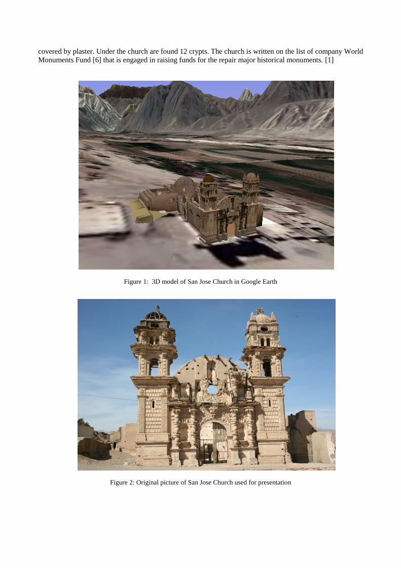
covered by plaster. Under the church are found 12 crypts. The church is written on the list of company World
Monuments Fund [6] that is engaged in raising funds for the repair major historical monuments. [1]
Figure 1: 3D model of San Jose Church in Google Earth
Figure 2: Original picture of San Jose Church used for presentation
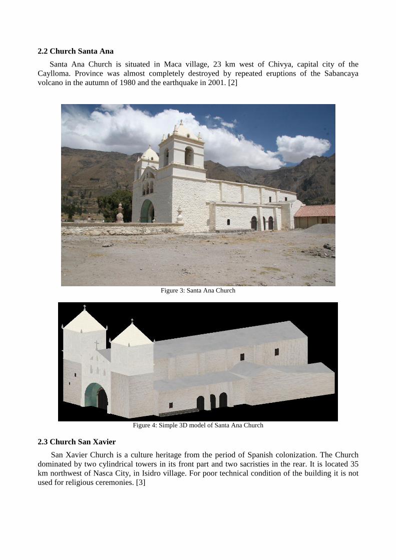
2.2 Church Santa Ana
Santa Ana Church is situated in Maca village, 23 km west of Chivya, capital city of the
Caylloma. Province was almost completely destroyed by repeated eruptions of the Sabancaya
volcano in the autumn of 1980 and the earthquake in 2001. [2]
Figure 3: Santa Ana Church
Figure 4: Simple 3D model of Santa Ana Church
2.3 Church San Xavier
San Xavier Church is a culture heritage from the period of Spanish colonization. The Church
dominated by two cylindrical towers in its front part and two sacristies in the rear. It is located 35
km northwest of Nasca City, in Isidro village. For poor technical condition of the building it is not
used for religious ceremonies. [3]
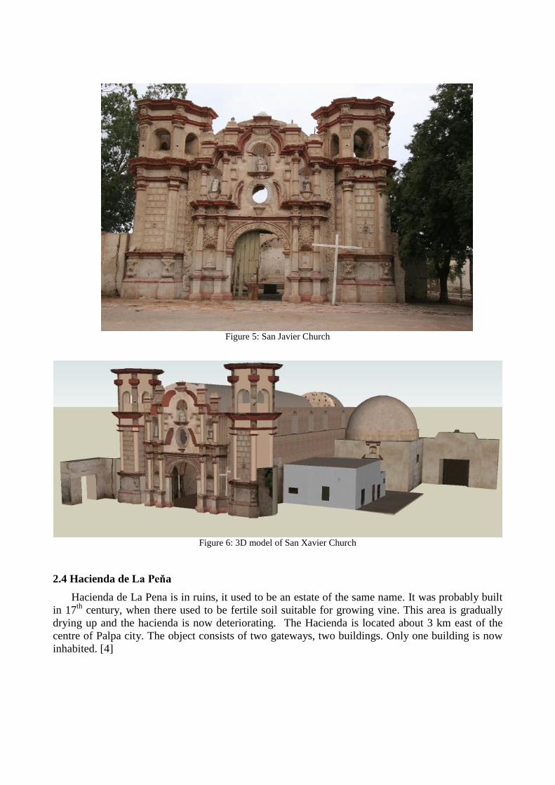
Figure 5: San Javier Church
Figure 6: 3D model of San Xavier Church
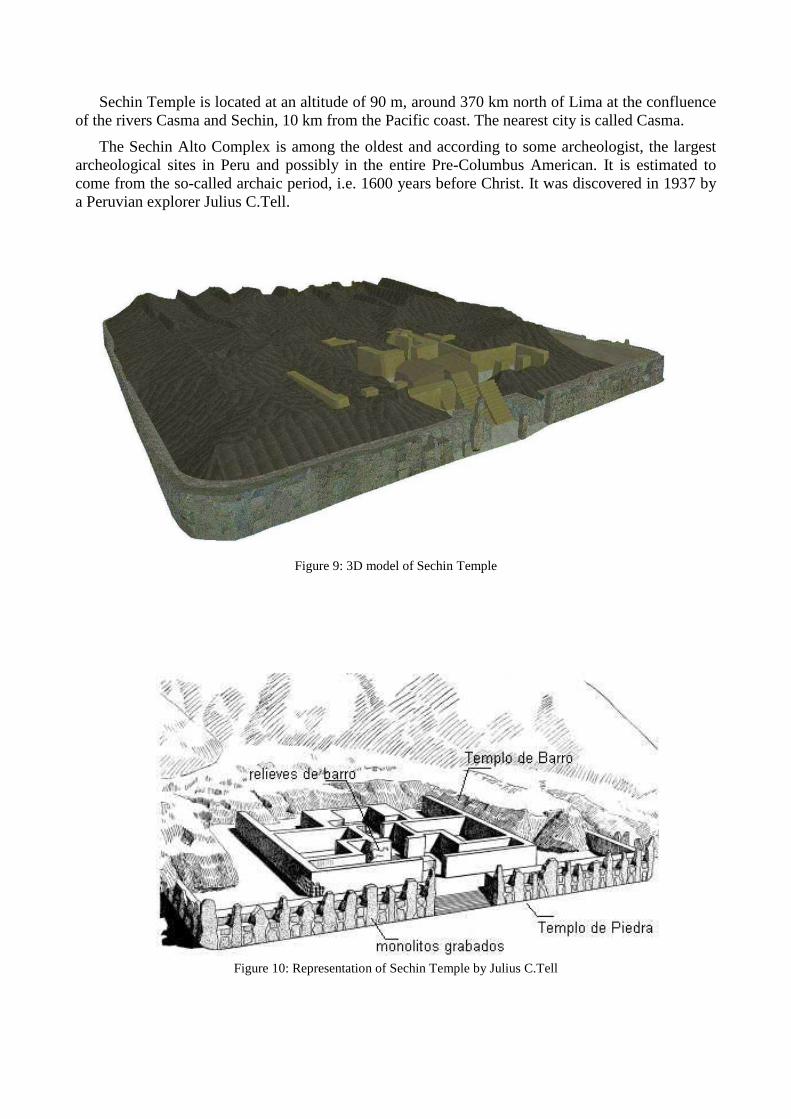
2.4 Hacienda de La Peňa
Hacienda de La Pena is in ruins, it used to be an estate of the same name. It was probably built
in 17th
century, when there used to be fertile soil suitable for growing vine. This area is gradually
drying up and the hacienda is now deteriorating. The Hacienda is located about 3 km east of the
centre of Palpa city. The object consists of two gateways, two buildings. Only one building is now
inhabited. [4]
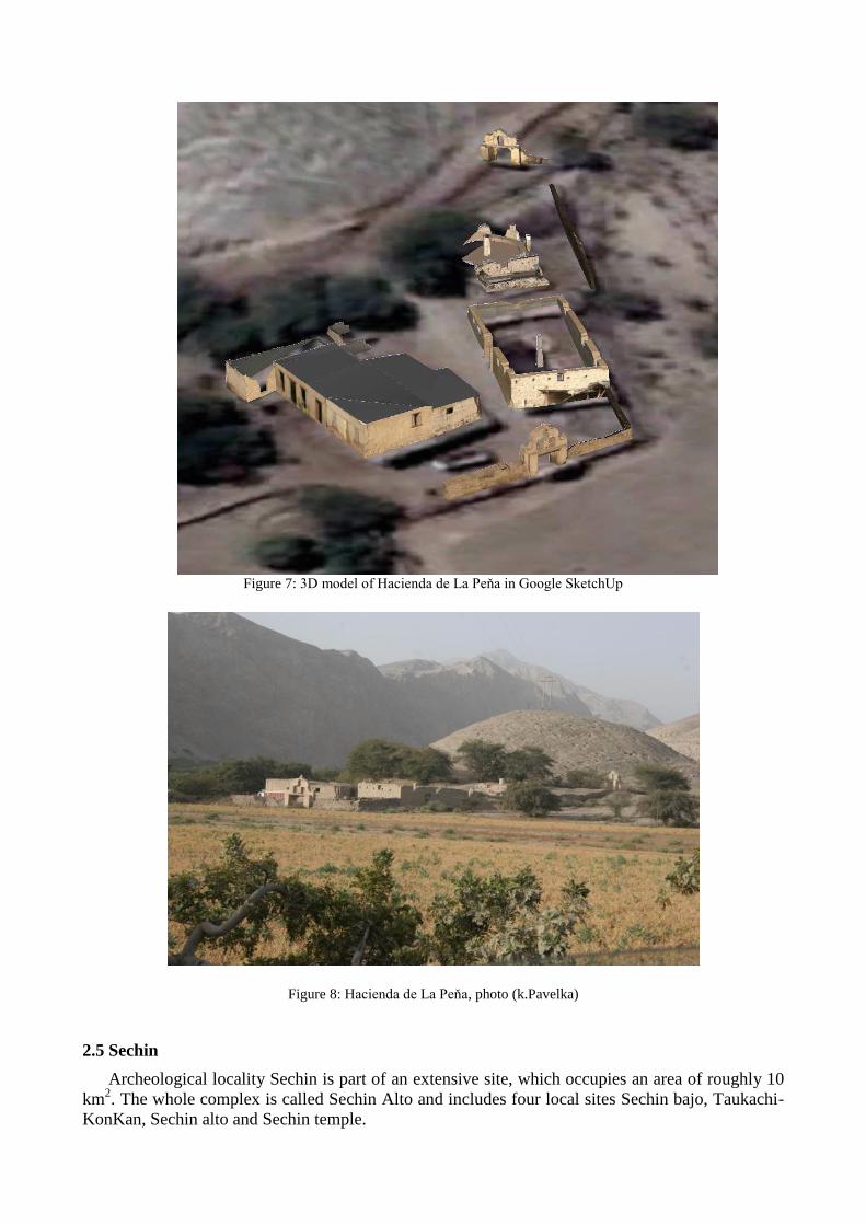
Figure 7: 3D model of Hacienda de La Peňa in Google SketchUp
Figure 8: Hacienda de La Peňa, photo (k.Pavelka)
2.5 Sechin
Archeological locality Sechin is part of an extensive site, which occupies an area of roughly 10
km2. The whole complex is called Sechin Alto and includes four local sites Sechin bajo, Taukachi-
KonKan, Sechin alto and Sechin temple.
Sechin Temple is located at an altitude of 90 m, around 370 km north of Lima at the confluence
of the rivers Casma and Sechin, 10 km from the Pacific coast. The nearest city is called Casma.
The Sechin Alto Complex is among the oldest and according to some archeologist, the largest
archeological sites in Peru and possibly in the entire Pre-Columbus American. It is estimated to
come from the so-called archaic period, i.e. 1600 years before Christ. It was discovered in 1937 by
a Peruvian explorer Julius C.Tell.
Figure 9: 3D model of Sechin Temple
Figure 10: Representation of Sechin Temple by Julius C.Tell
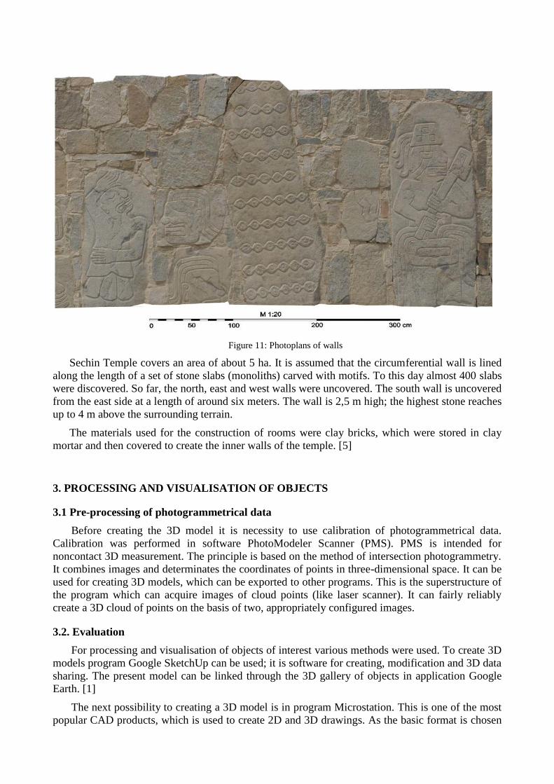
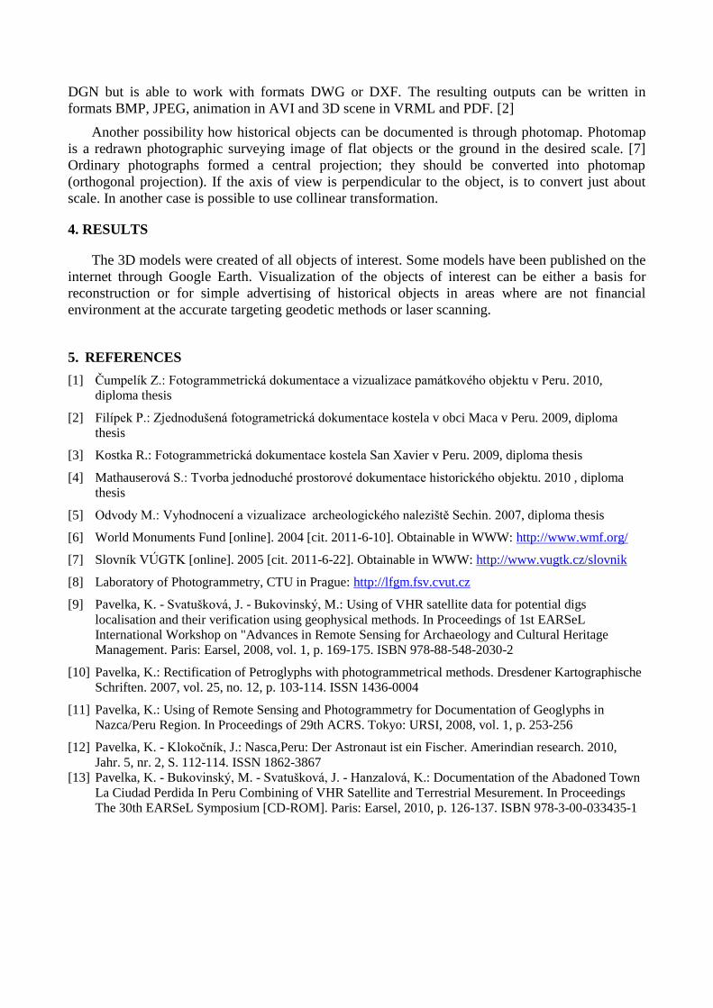
Figure 11: Photoplans of walls
Sechin Temple covers an area of about 5 ha. It is assumed that the circumferential wall is lined
along the length of a set of stone slabs (monoliths) carved with motifs. To this day almost 400 slabs
were discovered. So far, the north, east and west walls were uncovered. The south wall is uncovered
from the east side at a length of around six meters. The wall is 2,5 m high; the highest stone reaches
up to 4 m above the surrounding terrain.
The materials used for the construction of rooms were clay bricks, which were stored in clay
mortar and then covered to create the inner walls of the temple. [5]
3. PROCESSING AND VISUALISATION OF OBJECTS
3.1 Pre-processing of photogrammetrical data
Before creating the 3D model it is necessity to use calibration of photogrammetrical data.
Calibration was performed in software PhotoModeler Scanner (PMS). PMS is intended for
noncontact 3D measurement. The principle is based on the method of intersection photogrammetry.
It combines images and determinates the coordinates of points in three-dimensional space. It can be
used for creating 3D models, which can be exported to other programs. This is the superstructure of
the program which can acquire images of cloud points (like laser scanner). It can fairly reliably
create a 3D cloud of points on the basis of two, appropriately configured images.
3.2. Evaluation
For processing and visualisation of objects of interest various methods were used. To create 3D
models program Google SketchUp can be used; it is software for creating, modification and 3D data
sharing. The present model can be linked through the 3D gallery of objects in application Google
Earth. [1]
The next possibility to creating a 3D model is in program Microstation. This is one of the most
popular CAD products, which is used to create 2D and 3D drawings. As the basic format is chosen
DGN but is able to work with formats DWG or DXF. The resulting outputs can be written in
formats BMP, JPEG, animation in AVI and 3D scene in VRML and PDF. [2]
Another possibility how historical objects can be documented is through photomap. Photomap
is a redrawn photographic surveying image of flat objects or the ground in the desired scale. [7]
Ordinary photographs formed a central projection; they should be converted into photomap
(orthogonal projection). If the axis of view is perpendicular to the object, is to convert just about
scale. In another case is possible to use collinear transformation.
4. RESULTS
The 3D models were created of all objects of interest. Some models have been published on the
internet through Google Earth. Visualization of the objects of interest can be either a basis for
reconstruction or for simple advertising of historical objects in areas where are not financial
environment at the accurate targeting geodetic methods or laser scanning.
5. REFERENCES
[1] Čumpelík Z.: Fotogrammetrická dokumentace a vizualizace památkového objektu v Peru. 2010,
diploma thesis
[2] Filípek P.: Zjednodušená fotogrametrická dokumentace kostela v obci Maca v Peru. 2009, diploma
thesis
[3] Kostka R.: Fotogrammetrická dokumentace kostela San Xavier v Peru. 2009, diploma thesis
[4] Mathauserová S.: Tvorba jednoduché prostorové dokumentace historického objektu. 2010 , diploma
thesis
[5] Odvody M.: Vyhodnocení a vizualizace archeologického naleziště Sechin. 2007, diploma thesis
[6] World Monuments Fund [online]. 2004 [cit. 2011-6-10]. Obtainable in WWW: http://www.wmf.org/
[7] Slovník VÚGTK [online]. 2005 [cit. 2011-6-22]. Obtainable in WWW: http://www.vugtk.cz/slovnik
[8] Laboratory of Photogrammetry, CTU in Prague: http://lfgm.fsv.cvut.cz
[9] Pavelka, K. - Svatušková, J. - Bukovinský, M.: Using of VHR satellite data for potential digs
localisation and their verification using geophysical methods. In Proceedings of 1st EARSeL
International Workshop on "Advances in Remote Sensing for Archaeology and Cultural Heritage
Management. Paris: Earsel, 2008, vol. 1, p. 169-175. ISBN 978-88-548-2030-2
[10] Pavelka, K.: Rectification of Petroglyphs with photogrammetrical methods. Dresdener Kartographische
Schriften. 2007, vol. 25, no. 12, p. 103-114. ISSN 1436-0004
[11] Pavelka, K.: Using of Remote Sensing and Photogrammetry for Documentation of Geoglyphs in
Nazca/Peru Region. In Proceedings of 29th ACRS. Tokyo: URSI, 2008, vol. 1, p. 253-256
[12] Pavelka, K. - Klokočník, J.: Nasca,Peru: Der Astronaut ist ein Fischer. Amerindian research. 2010,
Jahr. 5, nr. 2, S. 112-114. ISSN 1862-3867
[13] Pavelka, K. - Bukovinský, M. - Svatušková, J. - Hanzalová, K.: Documentation of the Abadoned Town
La Ciudad Perdida In Peru Combining of VHR Satellite and Terrestrial Mesurement. In Proceedings
The 30th EARSeL Symposium [CD-ROM]. Paris: Earsel, 2010, p. 126-137. ISBN 978-3-00-033435-1