silverberry landfill capacity expansion project description · in-person meetings, working groups,...
TRANSCRIPT

Silverberry Landfill Capacity Expansion
Project Description
08-088-20W6M
Submitted under:
Canadian Environmental Assessment Act, 2012
Submitted by:
Tervita Corporation
February 2016
Table of Contents
1.0 General Information and Contacts ................................................................... 1
1.1 - Nature of Designated Project and Proposed Location .......................................... 1
1.2 - Proponent Information .................................................................................. 3
1.3 - Consultation with Other Parties Including Aboriginal Groups ................................ 3 1.4 - Regulatory Requirements of Other Jurisdictions ................................................. 6
1.5 - Presence of Environmental Study .................................................................... 6
2.0 Project Information ......................................................................................... 7
2.1 - General Description under Regulations Designating Physical Activities .................. 7 2.2 - Provisions in the Schedule to the Regulations Designating Physical Activities ......... 7
2.3 - Components Associated with the Designated Project ......................................... 13
2.4 - Emissions, Discharges and Waste ................................................................... 16
2.5 - Project Schedule .......................................................................................... 16
3.0 Project Location ............................................................................................ 17
3.1 - Facility Coordinates ...................................................................................... 17
3.2 - Zoning Designation of Land ........................................................................... 21
3.3 - Land/Water use Plans Near Project Site .......................................................... 21
3.4 - Impact on Aboriginal Traditional Land Use ....................................................... 21
4.0 Federal Funding ............................................................................................. 22
4.1 - Financial Support from Federal Authorities ...................................................... 22
4.2 - Federal Lands Used Under Designated Project .................................................. 22
4.3 - List Federal Permits, Licenses or Other Required Authorizations .......................... 22
5.0 Environmental Effects .................................................................................... 23
5.1 - Physical and Biological Setting ....................................................................... 23
5.2 - Potential Impact to Fish and Fish Habitat, Marine Plants and Migratory Birds ........ 26
5.3 - Changes to the Environment on Federal Lands, Provinces or Outside Canada ....... 28
5.4 - Effects on Aboriginal Peoples ......................................................................... 28
6.0 Proponent Engagement and Interaction with Aboriginal Groups ................... 31
6.1 - List of Aboriginal Groups Potentially Interested / Affected by Designated Project ... 31
6.2 - Engagement and Consultation Activities with Aboriginal groups .......................... 31
6.3 - Consultation and Notification Plan .................................................................. 33
7.0 Consultation with the Public and Others ........................................................ 34
7.1 - Key Comments, Concerns and Response Expressed to date by Stakeholders ........ 34
8.0 References..................................................................................................... 36

Figures
Detailed Site Plan .................................................................................................... 2 Regional Overview Map ............................................................................................ 4 Project Overview Map ............................................................................................. 19 Treaty 8 Territory Overview ..................................................................................... 20 Tables
Table 2-1: Hazardous and Non-Hazardous Waste Volumes ............................................ 8 Table 2-2: BC Silverberry Secure Landfill and AB Hazardous Landfill Comparison ............ 11 Table 2-3: Facility Generated Emissions, Discharge and Waste ..................................... 16 Table 2-4: Project Schedule ..................................................................................... 16 Table 5-1: Species Observed During Field Work .......................................................... 27 Table 7-1: Public Consultation Schedule .................................................................... 34
Appendices
Appendix A - General Consultation and Notification Plan Appendix B - First Nations Consultation Plan

1 | P a g e
1.0 General Information and Contacts 1.1 - Nature of Designated Project and Proposed Location
Tervita Corporation (Tervita) owns and operates the Silverberry Secure landfill (the Facility)
which is approximately 50km north of Fort St John, British Columbia (BC). The Facility was
originally constructed in 2003 and currently consists of seven landfill cells with one to be developed under the existing approval, for a total approved capacity of 6,000,000 tonnes.
The Facility is constructed on privately owned land at 08-088-20W6M. Only solid, non-
secure (non-hazardous) and select secure (hazardous) oilfield, forestry and industrial
wastes are accepted for disposal at the landfill (see Section 2.2). The Facility currently
holds approval PR 17150 from the BC Ministry of Environment (MoE) and approval PAC
WD02-01 from the BC Environmental Assessment Office (EAO).
Tervita is seeking an amendment to PR 17150 and PAC WD02-01 to replace depleted
landfill capacity, which will provide for an estimated additional 30 year lifespan of the
Facility. The proposed capacity replacement project (the Project) consists of seven new
cells with 6,000,000 tonnes of capacity constructed in a staged approach over time on freehold lands currently owned by Tervita. The Project will not increase the input capacity
at the Facility but rather increase the total capacity.
Similar to the existing Facility footprint, the proposed Project is on privately owned land of
which a majority has been previously cleared and cultivated. The Project is located immediately east of the current landfill footprint on 08-088-20W6M. This land was subject
to an Environmental Impact Assessment as part of the original application for both the MoE
and EAO approvals. The Project area and associated components are shown in the Detailed
Site Plan.

NW
SESE
NE
SESE SW
NE
SW
888-20W6M
Cel l 9
Cel l 11
Cel l 13
Cel l 10 Cel l 12 Cel l 14
To pso ilStoc kpi le
Sub so i lStoc kp il e
Com m onStoc kp il e
Cel l 1 Cel l 2
Cel l 3 Cel l 4
Cel l 5
Cel l 6
Cel l 7 Cel l 8
Prop os edLate ra l
Ex p an s io n
BRITISHCOLUMBIA
AB
Vanc ouver
Prince Georg e
Kelow na
¯
Project Area !
661198
October 2015
UTM Zone 10NImagery: Esri, DigitialGlobe, GeoEye, i-cubed, USDA,
USGS, AEX, Getmapping, Aerogrid, IGN, IGP, swisstopo,and the GIS User Community; Roads: IHS Inc. 2015.
Mapped By: WL Checked By: HC
(All Locations Approximate)
Although there is no reason to believe that there are any errors associated with the data used to generate this product or in the product itself, users of these
data are advised that errors in the data may be present.
SCALE: 1:7,0000 50 100 150 200
m
\\ch2mhill\common\Shares\CNR\GIS_Proj2\VECA\661198\MAP_FILES\CEAA\ch661198_Fig1_Detailed_Site_150818.mxd
DETAILED SITE PLANTERVITA SILVERBERRY
SECURE LANDFILL CAPACITY REPLACEMENT
Access/Resource Road
Proposed Cell Block
Soil StockpileExisting Cell Block
Proposed Capacity Replacement

3 | P a g e
1.2 - Proponent Information
The name of the designated project is the “Silverberry Capacity Replacement Project.” The proponent information is as follows:
The name of the proponent and associated address:
Tervita Corporation 500, 140-10th Avenue SE
Calgary, AB, T2G 0R1
The Chief Executive Officer of Tervita:
Chris Synek
Chief Executive Officer
D: (403) 231-1139
The Principal Contact Person for the Project:
Peter Nelson
Advisor, Environment & Regulatory
D: (403) 234-4875
1.3 - Consultation with Other Parties Including Aboriginal Groups
In working with the EAO, consultation activities have been separated into a Public
Consultation Plan and a First Nations Consultation Plan.
Public Consultation Plan
The Public Consultation Plan will utilize a 3.2km radius for consultation and 5km radius for
notification to identify key stakeholder groups. Elected local municipal leaders will also be notified. Immediate residences, as well as the location of the designated Project relative to
existing features are shown in the Regional Overview Map.

k
k
k
kk
k
k
k
k
k
k
k
k
k
k
k
k
k
k
k
k
k
k
k
k
k
k
k
k
k
k
k
k
k
k
k
k
k
k
k
k
k
k
k
k
k
k
k
k
k
k
k
k
k
k
k
k
k
k
k
k
k
k
k
kk
k
k
k
k
k
k
k
k
k
k
k
k
k
k
k
k""""
""
TERVITA SILVERBERRY 16-07-088-20
1333002 ALBERTA SILVERBERRY 08-13-088-21
PENN WEST SILVERBERRY 13-07-088-20
PENN WEST SILVERBERRY 04-07-088-20
PEACERIVER
BlueberryRiver I.R. 205
Beatton Airport Road
Montney Creek
UpsetCr
eek
R 20 W6MR 21 W6M
T 87T 87
T 88
T 88
BRITISHCOLUMBIA
AB
Vanc ouver
Prince Georg e
Kelow na
¯
Project Area !
661198
October 2015
UTM Zone 10NHillshade: TERA Environmental Consultants 2008; EnergyFacilities and pipeline: IHS Inc. 2015; Fish Observation: BCMOE 2011; Residence: CH2M 2015; Roads: NRCan 2014;
Railway: NRCan 2012; Hydrology: NRCan 2007-2011;Transmission Line: BC Hydro 2011; City/Town: IHS Inc.2014; Indian Reserve: Government of Canada 2015;Wetland: BC Forests, Lands and Natural Resource
Operations 2008.
Mapped By: WL Checked By: HC
(All Locations Approximate)
Although there is no reason to believe that there are any errors associated with the data used to generate this product or in the product itself, users of these
data are advised that errors in the data may be present.
SCALE: 1:70,0000 500 1,000 1,500 2,000
m
\\ch2mhill\common\Shares\CNR\GIS_Proj2\VECA\661198\MAP_FILES\CEAA\ch661198_Fig2_Overview_150818.mxd
REGIONAL OVERVIEWTERVITA SILVERBERRY
SECURE LANDFILL CAPACITY REPLACEMENT
Indian Reserve/First Nation Settlement
WatercourseRailwayRoad
Residence""
Proposed Lateral Expansion
Known Fish ObservationEnergy Facilitiesk
Transmission Line
Existing Pipeline
WetlandWater Body
City/Town/Village
Existing Silverberry Landfill

5 | P a g e
Information Package
Tervita will hand-deliver project specific information to residents within 3.2km, as well as to
elected local municipal leaders. Packages will be mailed to other identified stakeholders
between 3.2km and 5km and will also be available at scheduled information session(s) and
on Tervita’s website. Information provided in the public consultation package will contain,
at a minimum, the following:
A Project overview;
Map of location and footprint;
Proposed scheduling;
Environmental considerations; Safety considerations; and
Tervita contacts.
Information Session(s)
Tervita will schedule and host at least two formal public information sessions (Open Houses) at a location within reasonable distance from the Project, noting the closest
feasible area is Buick, BC. Tervita project management employees and subject-matter
experts will be in attendance to provide information, address questions and record public
comment. The information sessions will be advertised in the local newspaper(s), while
notifications will be sent via direct mail to residents, occupants, landowners and other interested parties (stakeholders) within the designated notification radius. Tervita will
capture questions and comments along with the associated follow up/answers. Feedback
forms will be available at the information sessions for participants to request additional
material or who prefer written correspondence.
Tervita’s objective is to work with potentially affected stakeholders and interested parties to
identify adverse effects related to Tervita’s Project activities. Tervita’s objectives also
include:
Commencing consultation early in the Amendment planning process;
Identifying how stakeholders and interested parties wish to be consulted and
allowing flexibility in the manner and form of notification and consultation (e.g., in-person meetings, working groups, brochures, letters, phone calls, emails, mail
and/or websites);
Ensuring stakeholders and interested parties have an accurate understanding of
the Amendment and are given the opportunity to provide their feedback;
Communicating in plain language; Allowing sufficient time to review Amendment materials;
Adequately responding to concerns raised; and
Seek to avoid, address, mitigate or otherwise manage impacts identified
through the consultation process in a timely manner.
First Nations Consultation Plan
Since July 2014, Tervita has been involved in preliminary discussions with identified First
Nations as Tervita has worked to develop an understanding of issues, concerns and
interests related to Project activities. Tervita will continue to consult with identified BC

6 | P a g e
Treaty 8 First Nations. The Treaty 8 First Nations communities identified by the EAO are
identified below:
Blueberry River First Nations; and
Doig River First Nation.
While not specified by the EAO, Tervita has and will continue to communicate with, inform
and notify the following additional Treaty 8 First Nations:
Halfway River First Nation;
West Moberly First Nation; Saulteau First Nation;
Prophet River First Nations;
McLeod Lake Indian Band; and
Fort Nelson First Nation.
1.4 - Regulatory Requirements of Other Jurisdictions
The Facility currently operates under the following permits:
MoE permit: PR 17150 (as amended February, 2012); and
EAO permit: PAC WD02-01 (July 15, 2002).
The Project is subject to an Environmental Assessment as per the BC Environmental
Management Act - Reviewable Project Regulations. A project description was submitted to
the EAO in February 2014, with the EAO acknowledging that the project was reviewable.
1.5 - Presence of Environmental Study
The designated project will not be taking place in a federally sanctioned region that has
been the subject of an environmental study as confirmed verbally with the Canadian
Environmental Assessment Agency (CEAA) on August 10, 2015.

7 | P a g e
2.0 Project Information
2.1 - General Description under Regulations Designating Physical Activities
In 2002, Tervita (formally CCS Inc.) was issued approvals from the EAO and MoE. The EAO issued PAC WD02-01 and MoE issued PR 17150 for the construction and operation of the
Facility. The landfill opened its first cell in October 2002, with additional cells constructed in
2003, 2006, 2008, 2011, 2012, and 2015. It is anticipated that the current operating cell
(cell 6) will reach maximum capacity by 2016, and the final cell of the originally approved
Facility footprint will be constructed and filled to capacity by 2018. Tervita is seeking to amend PAC WD02-01 and PR 17150 to incorporate an additional area approximately the
same size as the original 25-hectare landfill, which would provide for an estimated
additional 30 year lifespan of the Facility. The designated Project is deemed to fall under an
activity listed in the CEAA Regulations Designating a Physical Activity as per Section 2.2 of
this Project Description.
2.2 - Provisions in the Schedule to the Regulations Designating Physical Activities
As per previous communications and as deemed in a formal letter sent by CEAA August 6,
2015, Paragraph 30 of the Act, applies to Tervita’s Project, as it has been deemed
reviewable since “The construction, operation, decommissioning and abandonment of [the] Facility is used exclusively for the treatment, disposal or recycling of hazardous waste, or
an expansion of a Facility that would result in an increase in its production capacity of more
than 50%”.
Tervita acknowledges CEAA’s interpretation of Paragraph 30. Tervita is pleased to provide the following information on the operations of the landfill as context for CEAA in the review
of the Project. The Silverberry landfill is not used exclusively as a hazardous waste facility.
As seen in Table 2-1, a significant portion of the waste is non-hazardous, (non-hazardous
by both provincial and federal standards).
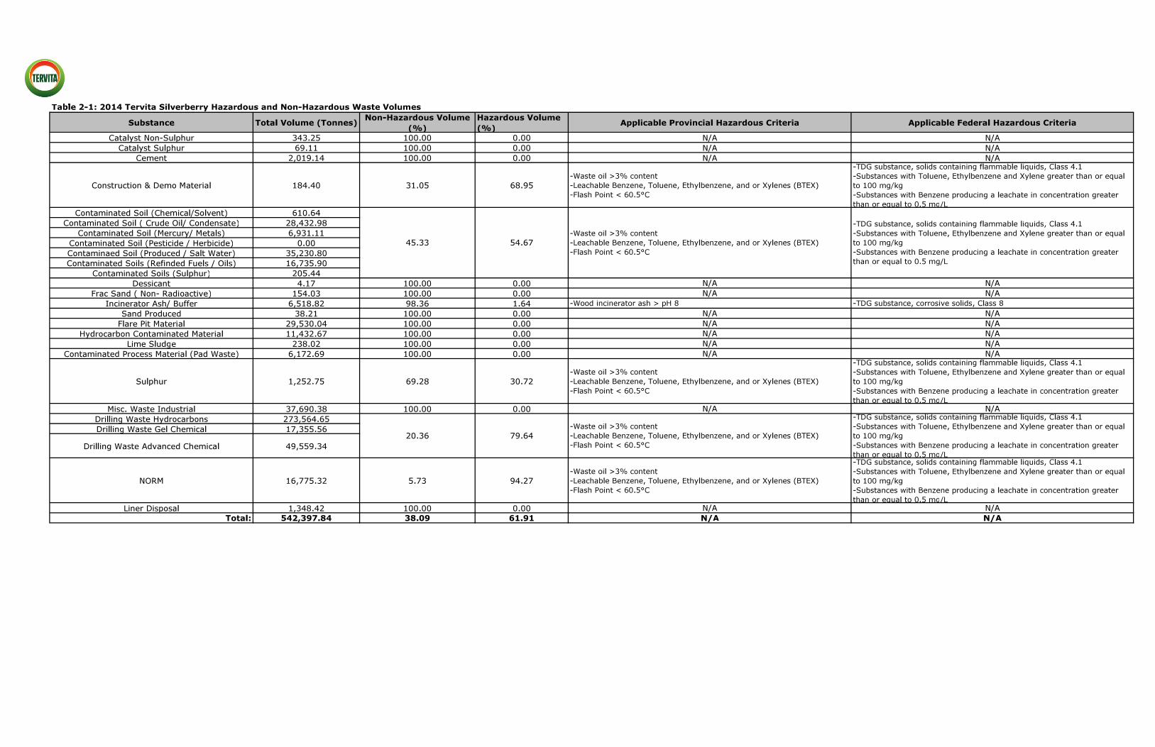
9 | P a g e
Only solid, non-hazardous and select hazardous oilfield, forestry and industrial wastes are
accepted for disposal at the landfill. In determining the breakdown of hazardous versus
non-hazardous waste, Tervita reviewed both Provincial and Federal criteria. In 2014,
approximately 40% of the waste accepted into the landfill was non-hazardous. Of the
remaining 60% of waste streams which have the potential to be hazardous, only a portion
were deemed hazardous.
The Facility is permitted to accept only the following secure (hazardous) wastes based on
Provincial HWR regulations.
Waste Oil >3% Content; Leachable Benzene, Toluene, Ethylbenzene, and/or Xylenes (BTEX) less than a total
combined concentration of 1,000 mg/kg;
Flash Point <60.5°C (only applies to Solids containing Flammable Liquids TDGR
UN3175); and
Wood/Incinerator Ash >pH 8.0.
Federally, hazardous waste is determined using the Export and Import of Hazardous Waste
and Hazardous Recyclable Material Regulations and align with the definition of provincially
permitted hazardous waste. The Silverberry landfill can only accept the following hazardous
waste based on Federal parameters:
Section 1(b) TDG Substance, Solids Containing Flammable Liquids, Class 4.1
UN3175;
Section 1(b) TDG Substance, Corrosive Solids, Class 8 (Silverberry only accepts
wood ash or incinerator ash with a pH greater than 12.5);
Section 1(d), substances with Toluene, Ethylbenzene and Xylene in total combined concentrations greater than or equal to 1,000 mg/kg (including Benzene); and
Section 1(e), substances with Benzene producing a leachate (TCLP) in concentration
greater than or equal to 0.5 mg/L.
Resultantly, only the following waste streams accepted at the Facility have the potential (depending on concentrations) to be hazardous:
Contaminated Soils (Crude Oil / Condensate);
Contaminated Soils (Refined Fuels / Oils);
Flare Pit Material; Hydrocarbon Contaminated Material;
Drilling Waste Hydrocarbons; and
Incinerator Ash/Buffer.
As per in Table 2-1, these waste streams make up approximately 60% of the waste
accepted at the Facility, of which only a portion meets the criteria for hazardous waste. It is important to note, given the variability in the nature of how these wastes are generated
that they do not consistently meet the criteria for hazardous waste and thus only a portion
of the 60% is hazardous.
Due to strict limitations within the Facility approvals on what hazardous wastes are accepted, the ability of the Facility to accept hazardous wastes is very limited when

10 | P a g e
compared to other Secure landfills in Alberta. This comparison is highlighted in Table 2-2,
in which allowable limits for a Secure landfill in BC are compared to a Class I landfill in
Alberta.

11 | P a g e
Table 2-2: BC Silverberry Secure Landfill and AB Hazardous Landfill Comparison
Chemical Name / Parameter
BC – Silverberry Secure Landfill
AB – Hazardous Waste Landfill
Comments
Flash Point Less Than 60.5°C Less Than 60.5°C
Silverberry landfill ONLY applies to
Solids Containing
Flammable Liquids
TDGR UN3175
pH 2.0 – 12.5
Greater than 12.5
applies to broad waste stream
Silverberry landfill
pH greater than 8.0
ONLY applies to Wood ash and
Incinerator ash
Benzene Combined total of
BTEX must be equal to or less than 1,000
mg/kg
Combined total of
BTEX must be equal to or less than 1,000
mg/kg
- Toluene
Ethylbenzene
Xylene(s)
Waste Oil Greater than 3%
waste oil content -
ONLY applies in the
province of BC
Leachable Metals
Arsenic Non-Haz levels only
Hazardous
acceptance approved
500 mg/L
-
Beryllium Non-Haz levels only
Hazardous
acceptance approved 100 mg/L
-
Cadmium Non-Haz levels only Hazardous acceptance approved
100 mg/L
-
Chromium (VI) Non-Haz levels only
Hazardous
acceptance approved
500 mg/L
-
Lead Non-Haz levels only
Hazardous
acceptance approved
500 mg/L
-
Mercury Non-Haz levels only
Hazardous
acceptance approved 20 mg/L
-
Nickel Non-Haz levels only Hazardous acceptance approved
500 mg/L
-
Selenium Non-Haz levels only
Hazardous
acceptance approved
200 mg/L
-
Silver Non-Haz levels only
Hazardous
acceptance approved
100 mg/L
-

12 | P a g e
Table 2-2: BC Silverberry Secure Landfill and AB Hazardous Landfill Comparison
(continued)
Chemical Name /
Parameter
BC – Silverberry
Secure Landfill
AB – Hazardous
Waste Landfill
Comments
Leachable Metals
Thallium Non-Haz levels only Hazardous acceptance approved
200 mg/L
-
Miscellaneous Parameters
Extractable Organic
Halides (EOX) Non-Haz levels only
Hazardous
acceptance approved
1,000 mg/kg
-
Methyl Ethyl Ketone Non-Haz levels only
Hazardous
acceptance approved
6 mg/L
-
Total Combine
Organic Solvents Non-Haz levels only
Hazardous
acceptance approved
500 mg/L
-
Iso-butanol Non-Haz levels only
Hazardous
acceptance approved 11 mg/L
-
n-Butanol Non-Haz levels only Hazardous acceptance approved
6 mg/L
-
Carbon Disulfide Non-Haz levels only
Hazardous
acceptance approved
50 mg/L
-
Total Cresols Non-Haz levels only
Hazardous
acceptance approved
6 mg/L
-
Cyclohexanone Non-Haz levels only
Hazardous
acceptance approved 6 mg/L
-
Ethyl Acetate Non-Haz levels only Hazardous acceptance approved
6 mg/L
-
Ethyl Ether Non-Haz levels only
Hazardous
acceptance approved
6 mg/L
-
Nitrobenezene Non-Haz levels only
Hazardous
acceptance approved
6 mg/L
-
2-Nitropropane Non-Haz levels only
Hazardous
acceptance approved 6 mg/L
-
Pyridine Non-Haz levels only Hazardous acceptance approved
11 mg/L
-

13 | P a g e
2.3 - Components Associated with the Designated Project
The waste acceptance volumes are expected to remain consistent with the volumes in 2014
and will not result in an increase of hazardous waste input capacity of 50% or more. There
will be no new buildings or structures added to the Facility as part of the Project. Existing structures include a scale, a scalehouse, a quonset and a fuel tank for refueling equipment.
The Project will replace the Facility capacity with an additional 6,000,000 tonnes of volume
and increase the Facility’s lifespan to support regional economic activity.
The design of the capacity replacement is comprised of six cells of varying sizes. Cell construction is staged over time, as one is filled the next is built. As each cell is developed,
the liner and leachate collection systems will be tied together to provide a continuous liner
system under the entire expansion area. This will allow development of the expansion area
as one contiguous fill mass, rather than individual pockets, which is common landfill
construction practice. Additionally, the design of the capacity replacement provides for a 50m wide secure buffer zone on the property owned by Tervita, surrounding the active
area of the landfill.
Construction
Construction of the first cell is scheduled to start as soon as practicable following the
receipt of Project approvals and seasonal limitations. The current estimate is for
construction to start in summer 2017. The construction period for the initial cell will be
approximately two months, starting with major earthworks, proceeding through liner
installation and finishing with the leachate collection system installation.
Clearing and grubbing will be completed prior to excavation of the cell footprint. The
topsoil, subsoil and common material (clay) from the excavation will be removed and
stored in stockpile locations. Once the excavation is complete, select clay material
(1,000mm) will be placed back into the cell, compacted, and sloped to a common collection
point. Leak detection pipes overlaid by a double sided geocomposite drainage layer will be installed above the clay layer forming the leak detection system. This system is used to
detect the presence of free liquids that may have permeated the main liner system from
above, thereby, verifying physical integrity of the main cell. The main liner system consists
of a double sided geocomposite drainage layer underlain by a high-density polyethylene
(HDPE) liner and compacted clay liner (600mm). The main liner system is covered by a frost protection layer consisting of 200mm of granular buffer material and 500mm of select
waste. Construction of a typical cell is illustrated in Photo 2-1.

14 | P a g e
Photograph 2-1: Typical Cell Construction Photo
The construction labor force will consist of project engineers, liner installation specialists,
and contractors for general earthwork. The total labor force will vary from 5-20 persons at
any time, depending on the stage of construction. There will be no construction camp onsite. Construction personnel will likely be accommodated in Fort St. John, BC.
Operations
Guidance for operation of the landfill is provided by the current landfill Operations Plan. The
landfill Operations Plan is required to be approved by MoE as per PR 17150.
Waste will arrive at the site on trucks owned and operated by third party oilfield companies. There will be no increase in traffic volume as a result of the landfill expansion. Only solid,
non-secure (non-hazardous) and select secure (hazardous) oilfield, forestry and industrial
wastes are accepted for disposal at the landfill. Third-party food wastes or other readily
biodegradable wastes are not permitted for acceptance or disposal at the Facility. Gases
resulting from the decomposition of landfilled wastes are not expected due to the nature of the solid wastes. The Facility utilizes specific waste acceptance procedures, outlined in the
Operations Plan, prior to accepting and processing all incoming waste to ensure only
approved wastes are accepted.
The following procedures are designed to protect the environment, the interests of Tervita,
its’ customers, and to aid in ensuring only approved wastes are disposed of at the Facility. All material intended for disposal are subject to the following acceptance protocol:
Representative samples taken by the generator at point of origin;
Analysis completed by independent Standards Council of Canada accredited lab;

15 | P a g e
Completion of a Waste Approval Application;
Facility owner/operator review of waste documentation for issuance of Waste
Conformation Form;
Waste acceptance or refusal - waste acceptance is conditional on the results of gate
screening procedures; and
Waste is screened and weighed prior to unloading with all documentation in place at that time.
Hydrocarbon odors may be present at times in the vicinity of the active landfilling area, but
are not expected to be detectible at the Facility property boundaries. Emissions are
negligible and are only attributed to onsite heavy machinery.
Landfill leachate will be collected and stored within engineered lined ponds and trucked off-
site for disposal in injection wells. A third party provides trucking service while Tervita owns
and operates the injection wells and sites. The water injection wells are permitted by the
BC Oil and Gas Commission (OGC) and the BC MoE for disposal of non-hazardous waste. There will be no change to injection sites or wells as a result of the landfill expansion as the
existing site(s) have the capacity to handle. Leachate volumes are expected to remain
consistent as landfill cells are progressively capped in order to reduce the generation of
leachate.
Closure
An updated closure plan was submitted for review to the MoE on March 26th, 2015. Closure
costs for the Facility were updated in 2015 and the appropriate surety provided to the
Province of BC. As a requirement of the MoE permit, Tervita has to update closure costs for
the Facility annually and adjust financial security. The posting of security by Tervita serves to manage liability for the closure of the Facility. At the end of its operational life, the
Facility will be decommissioned and post closure activities will commence. Closure activities
will include the following:
Grading and compaction; Capping;
Soil cover (subsoil and topsoil);
Vegetation capping;
Removal of site infrastructure; and
General site restoration.
Post closure activities will include the following:
Leachate management;
Environmental monitoring;
Landfill cap maintenance; and General site maintenance.
Post closure activities will be completed for a minimum of 25 years upon Facility closure.

16 | P a g e
2.4 - Emissions, Discharges and Waste
The emissions, discharges and waste that will be generated as a result of construction and
operation are summarized in Table 2-3.
Table 2-3: Facility Generated Emissions, Discharge and Waste
Waste Type Source Phase Location
Air Emissions (SOx,
,NOx and Particulate Matter)
Construction equipment
emissions while building
new landfill and dust from
roads
Construction and
Operation
Throughout landfill
roadways and expansion
Liquid Discharge Surface water collection Construction and
Operation Stormwater pond
Leachate
Water that comes into
contact with waste in the
landfill
Operation
Un-capped landfill
cells stored within a lined leachate
containment pond
Used Oil From equipment at
landfill
Construction and
Operation Used oil tank
Municipal Solid Waste
Day to day landfill operations
Construction and Operation
Operational Buildings
2.5 - Project Schedule
It is anticipated that the final cell of the existing Facility footprint will be constructed and
filled to capacity by 2018. Tervita estimates that all amendments will be in place by spring
2017 with construction to commence in summer 2017. A schedule is outlined in Table 2-4.
Table 2-4: Project Schedule
Phase of Project Activities Date
EAO and MoE permits
obtained Permitting Spring 2017
Equipment mobilized to site Transportation Spring 2017
Construction of landfill
expansion
Land clearing, excavating, grading, stockpiling of
excavated material,
compaction and liner
installation
Summer-Fall 2017
Demobilization of equipment Transportation Fall 2017
Landfill operation Excavating, grading, and
compaction 2017-2047
Closure or future expansion See section 2.3 2047

17 | P a g e
3.0 Project Location 3.1 - Facility Coordinates
The Facility is located at Latitude 56.626814 and Longitude -121.157348.
Site Map/Plans
The conceptual capacity replacement is illustrated in the Detailed Site Plan and shows a
total of six proposed cells. The area where the capacity replacement will occur is shown in
the photographs below, which were taken from the center of the proposed Project area. In
1963, the land was purchased from the Ministry of Crown Lands (Province of BC 1963). Between 1970 and 1972, the south part of Block A, Section 8 and Block B, Section 7 was
cleared. The Archeological Overview Assessment completed in 2002 deemed the area to
have low archeological potential.
Photograph 3-1: North View
Photograph 3-2: East View

18 | P a g e
Photograph 3-3: South View
Photograph 3-4: West View
Photographs 3-1 through 3-4 were taken in August, 2015 and illustrate the surrounding
landscape. The property was cleared more than 50 years ago and none of the proposed
development area is native, except for a small stand of trees (0.016km2) to the eastside of
the property
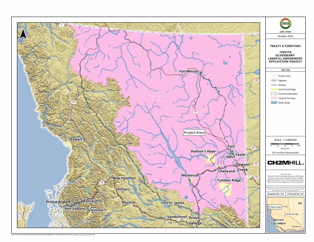
The Project Overview Map and Treaty 8 Territory Map illustrates the location of residences,
Federal lands and instances of settlement land. There are no Federal lands in the vicinity
except for the Blueberry First Nations reserve. The Project is within the Treaty 8 First
Nations Territory as per the Treat 8 Territory Overview.

""""
""
Crown Tenure – Right-of-Way
Crown Tenure – Reserve/Notation
Crown Tenure – Reserve/Notation
Crown Tenure – Inventory
Crown Tenure – Lease
Crown Tenure – Inventory
PEACERIVER
21
1120
30
11
21
20
30 BlueberryRiver I.R. 205
T.88R.20 W6M
T.88R.21W6M
36
34
25
2
18
32
25
34
3534
4
35
12
13
32
30
36
3
36
33
1
19
35
12
31
53
33
31
13
7
6
24
35
34
36
2
24
1
Beatton Airport Road
UpsetCr
eek
MontneyCreek
BRITISHCOLUMBIA
AB
Vanc ouver
Prince Georg e
Kelow na
¯
Project Area !
661198
October 2015
UTM Zone 10NImagery: Esri, DigitialGlobe, GeoEye, i-cubed, USDA,
USGS, AEX, Getmapping, Aerogrid, IGN, IGP, swisstopo,and the GIS User Community; Roads: NRCan 2014;
Railway: NRCan 2012; Watercourse: NRCan 2007-2011;Indian Reserve: Government of Canada 2015; Crownland
Tenure: BC MFLNRO 2008; Residence: CH2M 2015.
Mapped By: WL Checked By: HC
(All Locations Approximate)
Although there is no reason to believe that there are any errors associated with the data used to generate this product or in the product itself, users of these
data are advised that errors in the data may be present.
SCALE: 1:70,0000 500 1,000 1,500 2,000
m
\\ch2mhill\common\Shares\CNR\GIS_Proj2\VECA\661198\MAP_FILES\CEAA\ch661198_Fig3_Site_Proximity_150818.mxd
PROJECT OVERVIEWTERVITA SILVERBERRY
SECURE LANDFILL CAPACITY REPLACEMENT
Indian Reserve/First Nation Settlement
WatercourseRailwayRoadResidence""
Proposed Lateral Expansion
Crown Land Tenure
Existing Silverberry Landfill
"
Treaty 8Territory
Project Area
UV1
UV37
UV97
UV59
UV64
UV58
UV2
UV29 UV49
UV16
Prince Rupert
PrinceGeorge
FortSt.
John
Terrace
DawsonCreek
Port Edward Kitimat
New Hazelton
Stewart
Houston
Smithers
MackenzieTumbler Ridge
Hudson's Hope Taylor
Fort Nelson
Fort St. James
Chetwynd
VanderhoofBRITISH
COLUMBIA
AB
Vanc ouver
Prince Georg e
Kelow na
¯
Project Area !
TREATY 8 TERRITORYTERVITASILVERBERRY LANDFILL AMENDMENT APPLICATION PROJECT
661198
October 2015
UTM Zone 10NHillshade: TERA Environmental Consultants 2008; Roadsand Provincial Boundary: ESRI 2005; Railways: USNIMA
2000; Municipalities: IHS Inc. 2014; Hydrography: IHS Inc.2004; Treaty Territory: Digitized from BC Gov Map 2007.
Mapped By: WL Checked By: HC
(All Locations Approximate)
Although there is no reason to believe that there are any errors associated with the data used to generate this product or in the product itself, users of these
data are advised that errors in the data may be present.
SCALE: 1:4,000,0000 25 50 75 100
Kilometres
\\ch2mhill\common\Shares\CNR\GIS_Proj2\VECA\661198\MAP_FILES\CEAA\ch661198_Treaty_Territory_Overview_151007.mxd
HighwayUV892RailwayCity/Town/Village
Treaty 8 TerritoryProvincial Boundary
Water Body
Project Area"

21 | P a g e
3.2 - Zoning Designation of Land
The legal land location of the Facility is 08-088-20W6M. The existing landfill and the Project
are located on privately owned land.
On February 28, 2002, the property was rezoned from Public Use to Oil and Gas Production to accommodate the construction of a secure landfill. There are four main land and
resources uses that occur within a 5km radius of the Facility – agriculture, forestry, oil and
gas exploration and development, and trapping.
3.3 - Land/Water use Plans Near Project Site
The Project falls within the Fort Nelson Land and Resource Management Study area, but is
not within any of the designated Resource Management Zones (Protected Zone, Special
Management Zone, General Management Zone, or Enhanced Resource Development Area).
The closest Resource Management Zone is the Enhanced Resource Development Zone which is approximately 100km northwest of the Facility.
3.4 - Impact on Aboriginal Traditional Land Use
The designated project area will not access, occupy, explore or develop land or resources
currently being used for traditional purposes by regional Aboriginal peoples. The Archeological Overview Assessment completed in 2002 deemed the area to have low
archeological potential.The current Facility is fenced to Provincial regulations. The Project is
on private land, and once constructed, it will also be fenced to the same standard as the
current Facility.

22 | P a g e
4.0 Federal Funding 4.1 - Financial Support from Federal Authorities
Tervita expects no financial support from Federal authorities.
4.2 - Federal Lands Used Under Designated Project
No Federal lands will be used for the purpose of the designated project.
4.3 - List Federal Permits, Licenses or Other Required Authorizations
No Federal permits, licenses or authorizations will be required.

23 | P a g e
5.0 Environmental Effects 5.1 - Physical and Biological Setting
Air Quality / Odor
The only source of emissions generation is from the excavators and bulldozers used to process waste at the Facility. There are no residents or neighbors near the Facility. Tervita
believes there is no need to mitigate this source at this time.
During periods of low precipitation, the Facility will use water collected in runoff controls
(i.e. ponds) to water roads for dust control. As there are no residents or neighbors near the
Facility, concerns related to dust are not anticipated.
The proposed disposition of wastes in a landfill will store the carbon in the waste fill and
result in negligible release of carbon dioxide to the atmosphere. Given the total volume of
waste to be landfilled over the life of the Project and expected carbon content of the waste,
there will be a significant net reduction of carbon dioxide released to the atmosphere. By direct landfilling materials, the carbon is being sequestered, thereby decreasing overall
greenhouse gas emissions.
Wildlife / Animal Mortalities
No significant habitat loss or alteration will occur on the Project site (a large majority of the
site was previously utilized for agriculture prior to the Facility being constructed). Any
potential impacts from the proposed Project on wildlife resources are likely to be highest in
the far east corner of the property, where there is a small treed area that is to be cleared.
Prior to the removal of the trees, a wildlife survey will be completed to assess and help develop mitigations as required for potential wildlife impact(s). The wildlife survey will
include a bird survey to identify potential and resulting effects to migratory birds.
Given the Project area is primarily cultivated land adjacent to the current operating landfill
footprint, there is little expected impact on wildlife habitat and habitat effectiveness.
Tervita will take into consideration when wildlife are most vulnerable (i.e. nesting or fledgling season) prior to any tree removal activities (Restricted Activity Period is between
May 1 - August 10).
Fisheries and Surface Water
The closest naturally occurring fish-bearing watercourse is over 1.2km north of the Project
footprint, and no permanent or defined drainage networks exists between the proposed
Project and the identified watercourse. Pathways to surface water exist when Tervita
discharges collected and tested water from the surface water control network. Tervita
discharges surface water via a controlled release to the soil (ground) in proximity to the surface water pond on the northern boundary of the Facility. Tervita will take care not to
discharge to saturated soil to minimize the potential of infiltration to nearby surface water
bodies.

24 | P a g e
The potential impact of the proposed Project on fish populations is disturbance to or
contamination of food sources in drainages upstream of fish-bearing habitat. The risk of
disturbance and contamination is low due to the proximity of the water bodies.
There are several engineered surface water bodies designed to manage runoff at the
Facility. Seasonal surface water drainage from the proposed Project (i.e., snow melt and rainfall) will be controlled by ditches, berms, and ponds. Surface drainage flows northwest
from the Facility, toward a surface water pond. All surface water within the Facility footprint
is directed and contained onsite. Engineered onsite surface controls do not contain fish and
are not considered suitable habitat.
Considering the characteristics of the natural environment as previously described, and the
scope of the Project operations and Project design, no potential impacts to aquatic
resources in the area are anticipated. The Facility will be constructed to meet design
requirements as per Section 27 of the HWR.
Groundwater
Potential impacts to the groundwater at the Facility and the surrounding area are
contamination of groundwater from landfill operations. The landfill is designed with liners,
leak detection and leachate collection systems that meet or exceed all applicable
requirements.
The groundwater flow at the site is to the northwest. The horizontal groundwater velocity
beneath the site was estimated to be less than 0.3m/year in 2014. The groundwater below
the landfill generally shows recharge conditions.
Tervita maintains a Groundwater Monitoring Program that samples onsite groundwater
wells and leachate collection points four times annually (spring, summer, fall, and winter).
The objectives of the Groundwater Monitoring Program are to meet the requirements of the
Facility’s MoE permit, to provide long-term monitoring of groundwater conditions at the
landfill, and to assess whether there are any effects on groundwater due to the landfill operations.
Regular groundwater monitoring has been conducted at the landfill before and after site
commissioning. The current groundwater monitoring well network consists of 11 active
monitoring wells. As documented in current and historical groundwater reports, data shows the activities of the Silverberry landfill have not impacted groundwater. Review of the leak
detection sample data indicates that the current leachate collection and containment
system(s) are operating properly.
Soils
The soils in the region are dominated by Orthic Gray, Orthic Dark, Gleyed Gray and Gleyed
Dark Gray Luvisols. The Orthic Gray Luvisols have a thin grayish Ae horizon, a transitional
AB or B4 horizon and a slowly pervious Bt horizon. The Dark Gray Luvisol is similar to the
Orthic profile except for the presence of an Ah horizon greater than 5cm thick. The Bt
horizon in these soils slows downward water movement, which often results in a perched

25 | P a g e
water table, during spring break up or after lengthy rainfall events. Color change from the
A to B horizons is generally poor.
Vegetation
The proposed Project footprint will primarily be on cultivated land. There is a small treed area to the east of the Facility and approximately 0.016km2 of vegetation will be removed.
Upon Facility closure, reclamation activities will be completed with the capped landfill cells
seeded with an approved regional seed mixture.
An Ecological assessment was completed and indicated that the treed area contains young aspen-rose-creamy peavine. One moist, shrubby area was observed at the eastern side of
the study area composed of willows, alder and bluejoint reedgrass. No invasive plant
species or rare plant species were documented.
Terrain
The topography of the site is sloped from the southeast to northwest at approximately 45
horizontal to 1 vertical (45:1). Approximately 30m of vertical relief is present within the
proposed landfill site.
Noise
There will be vehicle noise generated by both construction and operational phases of the
Project. Truck traffic, heavy equipment, back-up beepers, and speaker systems are typical
noises generated from Facility activities. These noise sources may be temporarily increased
during times of construction, however during normal Facility operations it is not expected to increase from current noise conditions.
The noise generation will occur regularly during the daylight hours where vehicular traffic is
at its peak; however, such noises are generally of a volume that would not normally be
noticeable outside the boundaries of the Facility. The closest seasonal neighbor is approximately 2.5km away. No significant noise impacts are anticipated from the Facility.
Economic and Social
The socio-economic effects resulting from the Project will be regionally positive. The Facility and the community will continue to benefit through regular, full-time employment in
Facility operations, as well as an increased number of jobs during construction phases of
the Project.
The landfill provides the oil and gas industry with an economically viable and
environmentally responsible waste management solution in northeastern BC. The existence of competitive disposal facilities in the area increases the economic viability of BC oil and
gas within the North American market, encourages further development leading to
increased royalty revenues for the Crown, and enhances employment and economic
opportunities within the region extending from Fort Nelson to Fort St. John.

26 | P a g e
The Facility will continue to provide permanent and contract employment positions
throughout the construction, operation, maintenance, expansion, and closure phases over
the lifetime of the Facility. The Facility currently employs 10 people to manage day to day
operations. During the addition of new landfill cells, up to 20 additional employees are
expected to be onsite throughout the construction phases.
Project activities such as construction may affect noise, air quality, surface water quality
and groundwater quality. The nearest residence is located farther than 3.5 km from the
proposed Project area. No noise complaints have been received at the existing Silverberry
secure landfill and the location of the proposed project is beside the existing landfill and as
such, the location of the source of noise will not alter how far the nearest residence is located.
Cultural and Heritage
Impacts to cultural and physical heritage as a result of the Project are not anticipated. In 1963, the land was purchased from the Ministry of Crown Lands. Between 1970 and 1972,
the south part of Block A, Section 8 and Block B, Section 7 was cleared. The Archeological
Overview Assessment completed in 2002 deemed the area to have low archeological
potential.
5.2 - Potential Impact to Fish and Fish Habitat, Marine Plants and Migratory Birds
Pathways to surface water exist when Tervita discharges collected and tested water from
the surface water control network. Tervita take care not to discharge to saturated soil to
minimize the potential of infiltration to nearby surface water bodies.
Given the Project area is primarily cultivated land adjacent to the current operating landfill
footprint, there is little expected impact on wildlife habitat and habitat effectiveness. On the
east edge of the proposed footprint, there is a stand of young aspen and alders that are
going to be mulched (approximately 0.016km2). The removal of the trees will result in
reduced habitat effectiveness in the immediate area; however, mitigation measures such as timing of mulching will be reviewed prior to removal of trees.
Peace Forest District lands surrounding the Project may provide habitat for wildlife species,
including mammals, birds and amphibians. Boreal forests, including coniferous, deciduous
and mixed wood stands, may provide nesting and foraging habitat for birds (e.g., songbirds and raptors), as well as thermal and security cover for mammals (e.g., moose). Seasonally
and permanently wet areas may provide nesting habitat for waterfowl and riparian birds,
breeding habitat for amphibians, and foraging habitat for mammals. The BC Conservation
Data Centre, identified 47 potentially occurring species at risk in the Peace Forest District
(which includes the Project Area), including 42 species on the provincial red and blue lists,
and 15 species listed as Threatened, Endangered or Special Concern on Schedule 1 of the Species At Risk Act (SARA), and 20 migratory bird species. Recent wildlife fieldwork
identified 4 mammal species, 23 bird species (of which 21 are migratory and 19 are not at
risk) and 1 amphibian species within the Project Area. As per Table 5-1, three species of
conservation concern were observed including Canada warbler (Blue listed in BC,
designated as Threatened on the SARA (Schedule 1), common nighthawk (designated as Threatened on SARA Schedule 1), and western toad (Blue listed in BC, designated as

27 | P a g e
Special Concern on SARA Schedule 1). The Project footprint is dominated by an agricultural
hayfield that is unlikely to provide suitable nesting or breeding habitat. However,
construction related noise is likely to be heard several hundred meters away before
dissipating to levels below ambient noise, which will likely result in sensory-related
disturbance to bird species in the forested portion of the Project footprint, or in nearby
habitats. Noise-related sensory disturbance could induce nest abandonment, or interfere with mating rituals. Mitigation measures will include: restrict clearing outside of known
fledging times and performing pre-construction surveys for active migratory bird nests
within the Project Footprint.
Table 5-1: Species Observed During Field Work
Birds
Species Migratory Species
(Yes/No) Special Status
American redstart Yes N/A
American robin Yes N/A
Black-and-white
warbler Yes N/A
Black-capped chickadee
No N/A
Canada warbler Yes SARA (Threatened)
Chipping sparrow Yes N/A
Clay-colored
sparrow Yes N/A
Common nighthawk Yes SARA (Threatened)
Golden-crowned
kinglet Yes N/A
Hermit thrush Yes N/A
House sparrow No N/A
Lazuli bunting Yes N/A
Northern harrier Yes N/A
Red-breasted nuthatch
Yes N/A
Red-eyed vireo Yes N/A
Ruby-crowned
kinglet Yes N/A
Savannah sparrow Yes N/A
Swainson's thrush Yes N/A
Townsend's
solitaire Yes N/A
White-throated
sparrow Yes N/A
Wilson's warbler Yes N/A

28 | P a g e
Table 5-1: Species Observed During Field Work (continued)
Birds
Species Migratory Species
(Yes/No) Special Status
Yellow-rumped
warbler Yes N/A
Mammals
Deer species N/A N/A
Elk N/A N/A
Moose N/A N/A
Red squirrel N/A N/A
Amphibians
Western toad N/A SARA (Special Concern)
5.3 - Changes to the Environment on Federal Lands, Provinces or Outside Canada
There will be no changes to the environment on Federal lands or any other province,
besides BC. The Project is being reviewed by the EAO.
5.4 - Effects on Aboriginal Peoples
Environmental effects of the Project will be contained onsite and will have minimal effects
to the Aboriginal peoples. Ongoing consultation in the form of project updates will be
completed with Aboriginal Peoples as the Project progresses. Potential environmental
effects related to Aboriginal peoples have been identified through the Canadian
Environmental Assessment Act 2012 (CEAA 2012), Section 5(1)(c). Environmental effects on Aboriginal people include:
Health conditions;
Socio-economic conditions;
Physical and cultural heritage; Current use of lands and resources; and
Historical/archaeological.
Health Effects
Health may be affected through air, surface water and groundwater pathways. Impacts to these pathways are expected to be limited to the Facility footprint.
The regional study area for air quality will encompass a 5.0km radius extending outwards
from the proposed Project Footprint boundary, including associated physical works and
activities. Heavy equipment will produce emissions which will be increased during construction but remain the same as they are now during operations. Perception of odour
and dust from construction equipment and wind erosion can affect quality of life; however,
due to the nature of the landfill materials, landfill gas generation will be minimal. Dust from
construction material handling and earth grading can affect terrestrial vegetation. Tervita
limits the impact of dust through watering site roads and waste, revegetation of soil

29 | P a g e
stockpiles and limiting the speed limit onsite. Implementing the above measures will limit
dust impacts to Tervita’s property boundary.
There is potential for contamination of surface water by the proposed Project due to
stormwater runoff. Runoff that has come into contact with waste will be handled as
leachate and segregated to ensure it is handled and disposed of properly. Leachate is collected in engineered lined ponds and shipped to water injection wells. The water
injection wells are permitted by the BC Oil and Gas Commission (OGC) and the BC MoE for
disposal of non-hazardous waste.
There are berms around the outside landfill boundary to stop the run-on of clean surface water and limit potential contamination. Ditching around the inside of the landfill boundary
collects surface water within the footprint and directs the water to an engineered surface
water pond. Surface water from the pond is tested for criteria laid out in the BC HWR prior
to discharge to ensure contaminants are not released to the environment. Surface water
quantity is not expected to be a concern as no changes to surface water quantity have been observed at the existing landfill. Construction and operation may introduce
groundwater contamination. Groundwater contamination may affect downstream surface
water, aquatic habitat or drinking water through migration of leachate through the soil to
groundwater or aquifers. The landfill liner system is designed to prevent contamination of
groundwater. Silverberry is built to Secure Landfill specifications as laid out in the BC
HWR. The composite primary liner system is a 1.5 mm thick HDPE primary liner with a 0.6 m thick Compacted Clay Liner (CCL) immediately below the HDPE. This is underlain by a
leak detection system and a secondary 0.6 m thick CCL. Liner materials may vary from
each cell development noting that design requirements of the HWR will be met. Information
from previous site investigations and data collection efforts (i.e., annual groundwater
monitoring program) will be completed on a scheduled basis to ensure the groundwater is not being contaminated.
Socio-economic Effects
The socio-economic effects resulting from the Project will be positive for the Aboriginal communities in the area as the Facility and the communities will continue to benefit
through potential opportunity in full-time employment in Facility operations, or work during
construction phases of the Project.
Physical and Cultural Heritage Effects
The proposed Project will not result in effects to the physical and cultural heritage of the
area as the proposed Project footprint will primarily be on cultivated land. There is a small
treed area to the east of the Facility and approximately 0.016km2 of vegetation will be
removed. The project on cultivated land and the removal of vegetation will not alter the
landscape in such a manner that it will effect physical and cultural heritage or alter the current land and resources for traditional purposes. Tervita has initiated consultation with
local Aboriginal trappers and any concerns will be addressed.
30 | P a g e
Current use of lands and resources
The current lands of the proposed footprint is owned by Tervita is not used for any
traditional purposes. Except for the vegetation onsite (0.016km2), the proposed footprint is
cultivated and hayed on a yearly. The land surrounding the proposed project area
Through meetings with the community, it was confirmed verbally that trapping was active
in the 1970s near the project area. However, due to development in the area, active
trapping by local first nations has not been conducted in the area for approximately 30
years.
Historical/Archaeological Effects
A previous Archeological Overview Assessment was completed in 2002 and deemed the
area to have low archeological potential. There are no structures, sites or things of
historical, archaeological, paleontological, or architectural significance that will be impacted.
31 | P a g e
6.0 Proponent Engagement and Interaction
with Aboriginal Groups
6.1 - List of Aboriginal Groups Potentially Interested / Affected by Designated
Project
Since July 2014, Tervita has been involved in preliminary discussions with the identified
First Nations and has worked to develop an understanding of issues, concerns and interest
related to Tervita’s activities. Tervita will continue to consult with identified BC Treaty 8
First Nations. Specifically, the Treaty 8 First Nations communities identified by the EAO are:
Blueberry River First Nations (BRFN); and
Doig River First Nation (DRFN).
While not specified by the EAO, Tervita has and will continue to communicate with, inform
and notify the following Treaty 8 First Nations:
Halfway River First Nation (HRFN);
West Moberly First Nation (WMFN);
Saulteau First Nation (SFN);
Prophet River First Nations (PRFN); McLeod Lake Indian Band (MLIB); and
Fort Nelson First Nation (FNFN).
The Project land is not currently and historically has not been used for traditional purposes
by Aboriginal groups or peoples. A previous Archeological Overview Assessment was completed in 2002 deemed the area to have low archeological potential.
6.2 - Engagement and Consultation Activities with Aboriginal groups
Tervita has provided Project information through pre-consultation communications with all
identified Treaty 8 First Nations. During preliminary discussions, questions were raised with regards to general operations, odor control, groundwater/surface water quality, wildlife
management and an increase in truck traffic during construction. Questions were addressed
through personal communications in which operations, standard operating practices as well
as best management practices were discussed. Tervita will continue ongoing
communications with the various Communities.
It was previously determined that the Project area would be subject to review under the
Archaeology Branch of the BC Ministry of Forests, Lands and Natural Resource Operations
(Heritage Conservation Act). An Archaeological Impact Assessment was completed and it
was determined that no archaeological resources have been found on the Project Footprint. The proposed Project has a low probability of affecting archaeological sites and historic
sites through direct disturbance.

32 | P a g e
Blueberry River First Nations
On April 14, 2015, Tervita met with BRFN Chief and Council for an initial meet and greet
and discussion of Silverberry Cell 7 construction (existing footprint). On April 30, 2015,
Tervita attempted to meet Chief and Council with Tervita’s CEO. On May 4, 2015, Tervita’s CEO and BRFN sat down for a Chief to Chief meeting. On May 20, 2015, Tervita met with
Blueberry River Enterprises to discuss opportunities to work together through the Cell 7
construction and possible future expansion. On June 30, 2015, Tervita notified BRFN about
the Amendment (capacity replacement) in an in person meeting with BRFN Council. Tervita
committed to work with BRFN to mitigate concerns, assist with community initiatives, provide capacity development and enhance awareness about Tervita operations.
Doig River First Nations
Tervita has met with DRFN and discussed the proposed Amendment. On October 2, 2014, DRFN Elders, land staff and youth toured the Facility. On April 16, 2015, Tervita met with
DRFN Chief and Council for preliminary discussions. On June 3, 2015, Tervita notified DRFN
of the Amendment in an in person meeting with DRFN Chief and Council. On July 5, 2015,
Tervita spent the day with DRFN at the Calgary Stampede (no formal project discussions
took place). Tervita committed to continue working with DRFN to mitigate concerns, assist
with community initiatives, provide capacity development and enhance awareness about Tervita operations.
Halfway River First Nation
Tervita has met with HRFN and discussed the proposed Amendment. On June 2, 2015, Tervita met with HRFN Land representatives to notify HRFN of the Amendment. No
concerns were expressed. HRFN requested to be included throughout the Amendment
process by phone, mail and email notification.
West Moberly First Nations
Tervita had scheduled a meeting with WMFN on June 2, 2015 that WMFN requested to
cancel. On June 4, 2015, Tervita sent an Amendment information package to WMFN by
mail and followed up with a telephone call. No concerns have been identified by WMFN to
date. Unless otherwise requested, Tervita will update WMFN regarding the Amendment by registered mail or courier.
Saulteau First Nations
Tervita has met with SFN and discussed the proposed Amendment. On October 7, 2014,
SFN Elders, lands staff and youth toured the facility. On June 2, 2015, Tervita met with SFN Land representatives to notify SFN of the Amendment. No concerns were expressed. SFN
requested to be included throughout the Amendment process by phone, mail and email
notification.
33 | P a g e
Prophet River First Nation
Tervita has met with PRFN and discussed the proposed Amendment. On June 1, 2015,
Tervita met with the PRFN Chief and Lands representatives to notify PRFN of the Project.
No concerns were expressed. PRFN requested to be included throughout the Amendment process by phone, mail and email notification.
McLeod Lake Indian Band
On June 4, 2015 Tervita sent an Amendment information package to MLIB by mail and followed up with a telephone call. No concerns have been identified by MLIB to date. Unless
otherwise requested, Tervita will update MLIB regarding the Amendment by registered mail
or courier.
Fort Nelson First Nation
On June 4, 2015, Tervita sent an Amendment information package to FNFN by mail and
followed up with a phone call. No concerns have been identified by FNFN to date. Unless
otherwise requested, Tervita will update FNFN regarding the Amendment by registered mail
or courier.
6.3 - Consultation and Notification Plan
Consultation and information gathering will be to the satisfaction of the EAO and the MoE.
Consultation will be conducted with the DRFN and BRFN in accordance with the EAO.
Tervita will address all pertinent concerns with these First Nations. A Project Description has been given to SFN, WMFN and PRFN. Tervita is exceeding EAO requirements by
engaging the above First Nations to ensure positive relations by way of regular Project
updates.

34 | P a g e
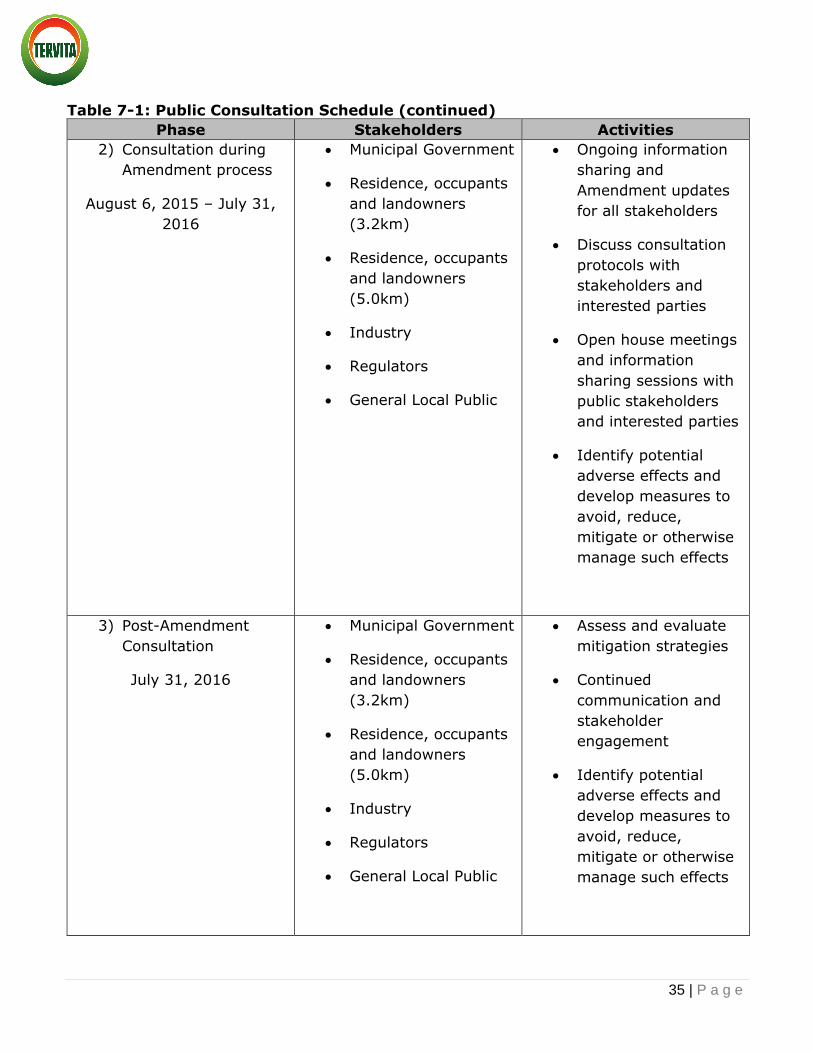
7.0 Consultation with the Public and Others 7.1 - Key Comments, Concerns and Response Expressed to date by Stakeholders
The Public Consultation Plan will utilize a 3.2km radius for consultation and 5km radius for
notification to identify key stakeholder groups as well as to elected local municipal leaders.
The stakeholder group, methods and timing of consultation and notification activities are outlined below in Table 7-1. Consultation completed with the public to date has not resulted
in any concerns. As consultation is ongoing, any new information will be recorded, updated
and communicated.
Table 7-1: Public Consultation Schedule
Phase Stakeholders Activities
1) Initial Consultation
July 1, 2015 – Ongoing
Municipal Government
Residence, occupants
and landowners
(3.2km)
Residence, occupants
and landowners
(5.0km)
Industry
Regulators
General Local Public
Introduce the
Amendment
Share conceptual
drawings and
Amendment materials
Request stakeholder
feedback
Facility tours
Identify potential
adverse effects and
develop measures to
avoid, reduce,
mitigate or otherwise
manage such effects
35 | P a g e
Table 7-1: Public Consultation Schedule (continued)
Phase Stakeholders Activities
2) Consultation during
Amendment process
August 6, 2015 – July 31,
2016
Municipal Government
Residence, occupants
and landowners
(3.2km)
Residence, occupants
and landowners
(5.0km)
Industry
Regulators
General Local Public
Ongoing information
sharing and
Amendment updates
for all stakeholders
Discuss consultation
protocols with
stakeholders and
interested parties
Open house meetings
and information
sharing sessions with
public stakeholders
and interested parties
Identify potential
adverse effects and
develop measures to
avoid, reduce,
mitigate or otherwise
manage such effects
3) Post-Amendment
Consultation
July 31, 2016
Municipal Government
Residence, occupants
and landowners
(3.2km)
Residence, occupants
and landowners
(5.0km)
Industry
Regulators
General Local Public
Assess and evaluate
mitigation strategies
Continued
communication and
stakeholder
engagement
Identify potential
adverse effects and
develop measures to
avoid, reduce,
mitigate or otherwise
manage such effects

36 | P a g e
8.0 References
British Columbia Hazardous Waste Guidelines. 2015. Accessed on September 11, 2015:
http://www.hazwastebc.com/hazardous-waste-guidelines/
British Columbia Conservation Data Centre. 2013. Conservation Data Centre Mapping Service – Mapped Known Locations of Species and Ecological Communities at Risk.
Accessed on February 14, 2014: http://www.env.gov.bc.ca/atrisk/ims.htm
British Columbia Conservation Data Centre. 2015. BC Species and Ecosystems Explorer.
Ministry of Environment. Accessed: October 2015. http://www.env.gov.bc.ca/atrisk/toolintro.html.
British Columbia Strategic Land and Resource Planning. Accessed on September 10, 2015:
https://www.for.gov.bc.ca/tasb/slrp/
Canada Land Inventory. 1970. Soil Capability for Agriculture. Charlie Lake 94A. 1:250000
map: http://sis.agr.gc.ca/cansis/nsdb/cli/index.html
Province of Alberta, 2013. Environmental Protection and Enhancement Act (Waste Control
Regulations): Accessed on September 14, 2015:
http://www.qp.alberta.ca/documents/Regs/1996_192.pdf
Province of Alberta. Alberta User Guide for Waste Managers: Accessed on September 11,
2015: http://environment.gov.ab.ca/info/library/7423.pdf
Province of British Columbia, 2002. Environmental Assessment Act: http://www.bclaws.ca/EPLibraries/bclaws_new/document/ID/freeside/00_02043_01
Province of British Columbia, 2009. Hazardous Waste Regulation:
http://www.bclaws.ca/EPLibraries/bclaws_new/document/ID/freeside/63_88_00
Province of British Columbia, 2002. Reviewable Projects Regulation:
http://www.bclaws.ca/EPLibraries/bclaws_new/document/ID/freeside/13_370_
Province of British Columbia, 2002. Reviewable Projects Regulation:
http://www.bclaws.ca/EPLibraries/bclaws_new/document/ID/freeside/13_370_

Appendix A - General Consultation and
Notification Plan

Public Consultation Plan for the
Proposed Silverberry PAC Amendment WD02-01
Submitted to the Environmental Assessment Office
By Tervita Corporation
October, 2015

1 | P a g e
1.0 INTRODUCTION
Tervita Corporation (Tervita) is a leading environmental solutions provider. Tervita’s integrated earth, water, waste and resource
solutions deliver safe and efficient results through all phases of a project by minimizing impact and maximizing returns. More than
2,000 dedicated employees are trusted sustainability partners to oil and gas, construction, mining, government and communities.
Safety is our highest priority: it influences our actions and shapes our culture.
Tervita is implementing a Public Consultation Plan (the Plan) in order to communicate our plans for engaging with public
stakeholders and interested parties regarding the proposed Silverberry Project Certificate Amendment (PAC) WD02-01 (the
Amendment).
The Plan is required under British Columbia’s (BC) Environmental Assessment Act and Regulations and was developed to meet the
consultation requirements as set out in the letters received by Tervita on November 6, 2014 and August 6, 2015, from BC’s
Environmental Assessment Office (EAO). The August 6, 2015 letter indicated that the following details must be included in Tervita’s
Plan:
Consultation principles;
Consultation activities conducted to date and the proposed consultation activities for the amendment;
Information delivery methods to provide notices and Silverberry information to stakeholders;
Timelines for consultation;
Procedures for tracking and reporting of consultation; and
List of identified stakeholders.
2 | P a g e
2.0 PROJECT OVERVIEW
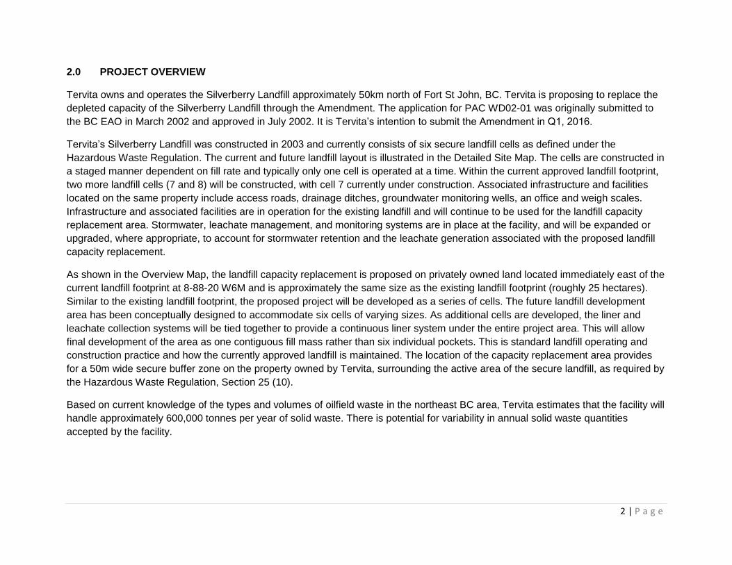
Tervita owns and operates the Silverberry Landfill approximately 50km north of Fort St John, BC. Tervita is proposing to replace the
depleted capacity of the Silverberry Landfill through the Amendment. The application for PAC WD02-01 was originally submitted to
the BC EAO in March 2002 and approved in July 2002. It is Tervita’s intention to submit the Amendment in Q1, 2016.
Tervita’s Silverberry Landfill was constructed in 2003 and currently consists of six secure landfill cells as defined under the
Hazardous Waste Regulation. The current and future landfill layout is illustrated in the Detailed Site Map. The cells are constructed in
a staged manner dependent on fill rate and typically only one cell is operated at a time. Within the current approved landfill footprint,
two more landfill cells (7 and 8) will be constructed, with cell 7 currently under construction. Associated infrastructure and facilities
located on the same property include access roads, drainage ditches, groundwater monitoring wells, an office and weigh scales.
Infrastructure and associated facilities are in operation for the existing landfill and will continue to be used for the landfill capacity
replacement area. Stormwater, leachate management, and monitoring systems are in place at the facility, and will be expanded or
upgraded, where appropriate, to account for stormwater retention and the leachate generation associated with the proposed landfill
capacity replacement.
As shown in the Overview Map, the landfill capacity replacement is proposed on privately owned land located immediately east of the
current landfill footprint at 8-88-20 W6M and is approximately the same size as the existing landfill footprint (roughly 25 hectares).
Similar to the existing landfill footprint, the proposed project will be developed as a series of cells. The future landfill development
area has been conceptually designed to accommodate six cells of varying sizes. As additional cells are developed, the liner and
leachate collection systems will be tied together to provide a continuous liner system under the entire project area. This will allow
final development of the area as one contiguous fill mass rather than six individual pockets. This is standard landfill operating and
construction practice and how the currently approved landfill is maintained. The location of the capacity replacement area provides
for a 50m wide secure buffer zone on the property owned by Tervita, surrounding the active area of the secure landfill, as required by
the Hazardous Waste Regulation, Section 25 (10).
Based on current knowledge of the types and volumes of oilfield waste in the northeast BC area, Tervita estimates that the facility will
handle approximately 600,000 tonnes per year of solid waste. There is potential for variability in annual solid waste quantities
accepted by the facility.

NW
SESE
NE
SESE SW
NE
SW
888-20W6M
Cel l 9
Cel l 11
Cel l 13
Cel l 10 Cel l 12 Cel l 14
To pso ilStoc kpi le
Sub so i lStoc kp il e
Com m onStoc kp il e
Cel l 1 Cel l 2
Cel l 3 Cel l 4
Cel l 5
Cel l 6
Cel l 7 Cel l 8
Prop os edLate ra l
Ex p an s io n
BRITISHCOLUMBIA
AB
Vanc ouver
Prince Georg e
Kelow na
¯
Project Area !
661198
October 2015
UTM Zone 10NImagery: Esri, DigitialGlobe, GeoEye, i-cubed, USDA,
USGS, AEX, Getmapping, Aerogrid, IGN, IGP, swisstopo,and the GIS User Community; Roads: IHS Inc. 2015.
Mapped By: WL Checked By: HC
(All Locations Approximate)
Although there is no reason to believe that there are any errors associated with the data used to generate this product or in the product itself, users of these
data are advised that errors in the data may be present.
SCALE: 1:7,0000 50 100 150 200
m
\\ch2mhill\common\Shares\CNR\GIS_Proj2\VECA\661198\MAP_FILES\CEAA\ch661198_Fig1_Detailed_Site_150818.mxd
DETAILED SITE PLANTERVITA SILVERBERRY
SECURE LANDFILL CAPACITY REPLACEMENT
Access/Resource Road
Proposed Cell Block
Soil StockpileExisting Cell Block
Proposed Capacity Replacement
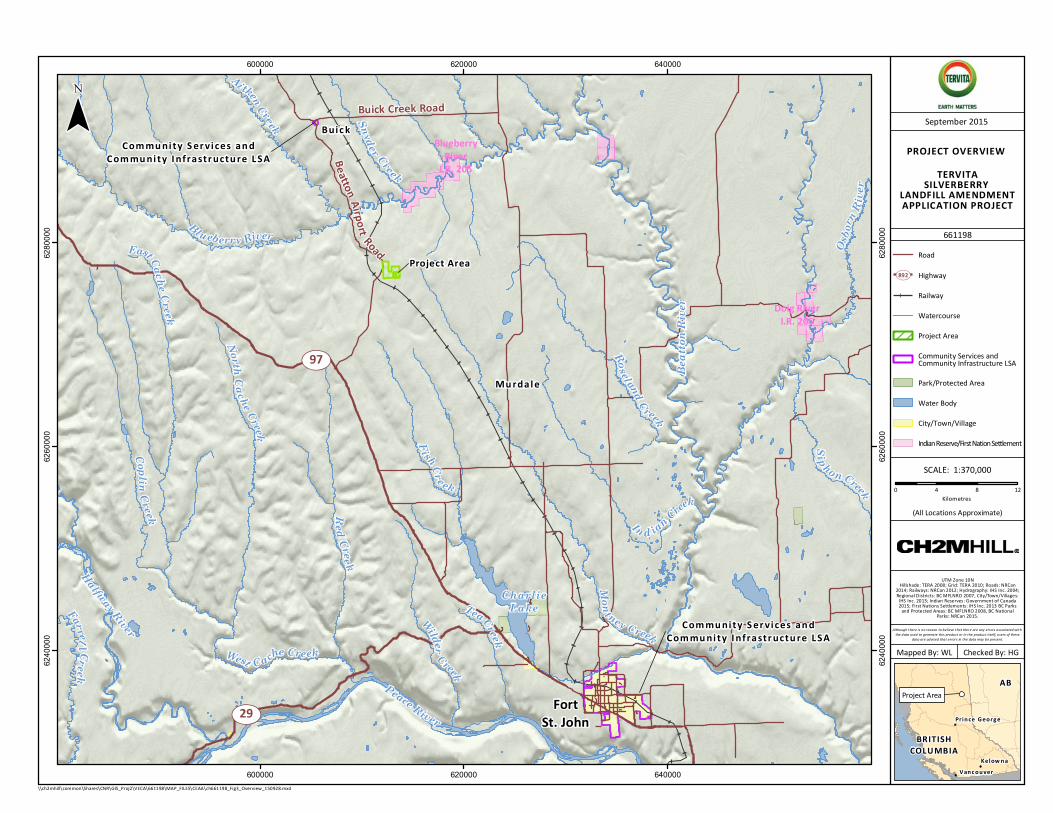
Project Area
Com mu ni ty S er v i ces an dCom mu ni ty I nfrastr uctu re L SA
Com mu ni ty S er v i ces an dCom mu ni ty I nfrastr uctu re L SA
UV97
UV29
Buick Creek Road
Beatton Airport Road
FortSt. John
TeaCreek
In d ian Creek
Osb o
rnRi
ver
Ai tkenCreek Snyder Creek
Copli nCreek
Fi shCreek
Farrell Creek
Sip hon Creek
Wilder
Creek
East Cache Creek
Roseland Creek
RedCreek
NorthCache Creek
Blueberry River
Mon tney Creek
West Cache Creek
CharlieLake
Peace River
Beat
ton
Rive
r
Halfway River
Doig RiverI.R. 206
BlueberryRiver
I.R. 205
600000
600000
620000
620000
640000
640000
6240
000
6240
000
6260
000
6260
000
6280
000
6280
000
BRITISHCOLUMBIA
AB
Vanc ouver
Prince Georg e
Kelow na
¯
Project Area !
PROJECT OVERVIEW TERVITASILVERBERRY LANDFILL AMENDMENT APPLICATION PROJECT
661198
September 2015
UTM Zone 10NHillshade: TERA 2008; Grid: TERA 2010; Roads: NRCan2014; Railways: NRCan 2012; Hydrography: IHS Inc. 2004;Regional Districts: BC MFLNRO 2007, City/Town/Villages:IHS Inc. 2013; Indian Reserves: Government of Canada2015; First Nations Settlements: IHS Inc. 2013 BC Parksand Protected Areas: BC MFLNRO 2008, BC NationalParks: NRCan 2015.
Mapped By: WL Checked By: HG
(All Locations Approximate)
Although there is no reason to believe that there are any errors associated with the data used to generate this product or in the product itself, users of these
data are advised that errors in the data may be present.
SCALE: 1:370,0000 4 8 12
Kilometres
\\ch2mhill\common\Shares\CNR\GIS_Proj2\VECA\661198\MAP_FILES\CEAA\ch661198_Fig3_Overview_150928.mxd
RailwayWatercourse
City/Town/VillageIndian Reserve/First Nation Settlement
HighwayUV892
Water Body
Project Area
Park/Protected Area
Road
Bui c k
Mu rda l e
Community Services and Community Infrastructure LSA

5 | P a g e
3.0 PROPOSED PROGRAM FOR PUBLIC CONSULTATION
Tervita recognizes that meaningful consultation with potentially impacted stakeholders and all interested parties is an important part
of project development and operations. Tervita’s consultation program is guided by our Stakeholder Relations Guiding Principles.
3.1 Guiding Principles – Stakeholder Relations
Tervita is committed to building positive relationships with stakeholders and all interested parties based on respect, trust
and open communication;
Tervita supports local community initiatives that reflect our commitment to sustainability and the quality of life of
communities where we live and work;
Tervita’s relationships with stakeholders and interested parties are based on the development of new projects and existing
operations as well as community interests; and
Tervita has defined consultation objectives (See Section 3.4 ).
The proposed public consultation program is designed to identify and engage stakeholders and/or other interested parties early in the
development process for this Project, and to provide them with an opportunity to participate and comment. The results of the public
consultation program will be documented and submitted to EAO as requested and incorporated into the final version of the Plan.

6 | P a g e
3.2 Public Consultation Overview
In seeking to determine the most appropriate consultation radius, Tervita looked first to the Oil & Gas Commission (OGC) guidelines
for similar projects. The OGC direction for the consultation radius is 1,300m and 1,800m for notification radius for projects similar to
the Silverberry PAC amendment. However, Tervita has chosen to utilize a larger radius and base our consultation and notifications
from the Alberta Energy Regulator radius for similar projects in using 3,200m for consultation and 5000m for notification as a
guideline. Tervita would utilize the principles of inclusiveness in the instance of a landowner residing immediately adjacent to the
applicable radius as per the Consultation and Notification Map.
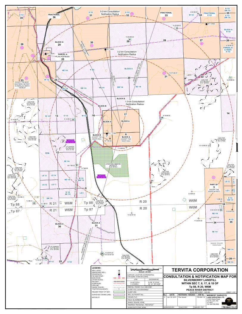
911: 18245
911:18225
911:13769
911: 17799
6-14-88-21 8-13-88-21
6-34-88-20
16-28-88-20
6-26-88-20
10-29-88-20
6-23-88-20
10-21-88-20
6-16-88-20
16-7-88-20
11-8-88-20
10-10-88-20
A4-7-88-20
4-7-88-20
6-2-88-21
1-2-88-21
4-1-88-21
12-25-87-21
A10-30-87-20
10-30-87-20
14-32-87-20
5-3-88-20
1-3-88-20
13-35-87-20A16-34-87-20
10-34-87-20
11-34-87-20
CAN-FORCUT-BLOCKID #: 01149
CAN-FORCUT-BLOCKID #: 01149
LP CANADACUT-BLOCKID #: 01149
CAN-FORCUT-BLOCKID #: 01031
CAN-FORCUT-BLOCKID #: S01048
CAN-FORCUT-BLOCKID #: 01031
LP CANADACUT-BLOCKID #: S01050
CAN-FORCUT-BLOCKID #: S27028
CAN-FORCUT-BLOCKID #: S27025
CAN-FORCUT-BLOCKID #: S27013
CAN-FORCUT-BLOCKID #: 27002
CAN-FORCUT-BLOCKID #: 27003
CAN-FORCUT-BLOCKID #: S27004
CAN-FORCUT-BLOCKID #: 27031
SE 1/4SW 1/4
BLOCK A
S 1/2SW 1/4
N 1/2SW 1/4
PARCEL B(L19264)
S 1/2
BLOCK AN 1/2
FRACTIONALE 1/2W 1/2
S 1/2S 1/2
S 1/2
N 1/2
SE 1/4SW 1/4
W 1/2
SE 1/4
NE 1/4
W 1/2 E 1/2 W 1/2
REM.
SE 1/4
LS 13 LS 14
LS 12 LS 11
SW 1/4
N 1/2SE 1/4
NE 1/4
LS 5
W 1/2 E 1/2
LS 12
LS 5
S 1/2SW 1/4
SE 1/4
NE 1/4
W 1/2
SW 1/4
NW 1/4
BLOCK B(EXCEPT THE
SOUTH 25m)
BLOCK A(EXCEPT THE
SOUTH 25m)
BLOCK A BLOCK A
2021
27
22
14
35
26
34FRACTIONAL
333231FRACTIONAL
3635
26BLOCK G
2530 29 28
1924
13 18
BLOCK B
17
BLOCK B
87
12
11 6
BLOCK A
36
BLOCK A
31
25
2(EXCEPT THE
SOUTH 80 FEET)
PART OF
3
34 35
34
26
23EXCEPT THE MOST
SOUTHERLY 80 FEET
IN PARALLEL WIDTH
THEREOF
JONATHAN GIBBONSWOODLOTID #: W1912
PARCEL A
PLAN PGP36305
25
W 1/2NW 1/4
11003 Alaska RoadFort St. John, BC
Tel: 250-785-3902V1J 6P3
MIDWEST SURVEYSLAND SURVEYING LTD.
CONSULTATION & NOTIFICATION MAP FORUTM GEOGRAPHIC
DWG No.: FB-0041-15-J1-25K-CNM
REVISION / ISSUEDNo. DATE JOB No.
0 Plan Issued
SCALE 1:25 000
SHEET 1 OF 1
UTM ZONE 10 NAD 83 (CSRS)
GUIDE/OUTFITTER: NONE
FIELD: SILVERBERRY
RANGE TENURE: NONE
TRAPPER: TR0745T001, TR0745T007
N: 6277375.5E: 612908.5
CLIENT FILE: 310-0000009552
WELL AUTHORITY No.:
CROWN FILE:
CLIENT AFE:
FB-0041-15-J1
Jun. 23, 2015 FB-0041-15
TERVITA CORPORATION
PEACE RIVER DISTRICTBCGS MAP SHEET - 94A.065
SURVEYED BY: CALC'D BY: DWN BY: PJP
Tp 88, R 20, W6M
SILVERBERRY LANDFILL
WITHIN SEC 7, 8, 17, & 18 OF
SURFACE LOCATION COORDINATES:
LEGEND:
SURVEYED CROWN LAND:
PIPELINE:
MAIN ROAD:
OTHER ROADS:
RAILWAY:
RANGE TENURE:
POWERLINE:
TRTRAPPER BOUNDARY:
WELL HEAD:
ABANDONED WELL:
RESIDENCES:3PID IDENTIFIER:
WOODLOT:
RAILWAY RIGHT OF WAY:
RANGE TENURERAN074494
TRAPPERTR0745T007
TRAPPERTR0745T001
0 1.00.50.5 1.5 2.0 Km
1
23
4
5
6
7
8
9
10
11
5
1.0 km Consultation/
Notification Radius
3.2 km Consultation/
Notification Radius
5.0 km Consultation/
Notification Radius

8 | P a g e
3.3 Methods of Sharing Information
The following methods will be used to share Amendment information:
Status report newsletters – Tervita will provide regular updates throughout the Project to identified stakeholders within our
3200m radius and those that request regular updates;
Information packages – documents will be hand delivered (dependent on distance from the facility), mailed (registered mail),
or emailed;
A dedicated public feedback and information request e-mail has been established to facilitate communication and information
sharing – [email protected];
One on one in-person meetings – as requested by public stakeholders and interested parties;
Information sessions (open house) – will be held either at the facility or in Buick, BC (dependent upon location availability)
with open invitations sent to those within the 5,000m notification radius and advertised in the local newspaper;
Facility tours – stakeholders will be invited to tour the facility and obtain a first-hand understanding of the operations; and
Newspaper notifications – project details will be shared in local newspapers, as required.
3.3.1 Status Report News Letter
Quarterly or at major milestones as determined throughout the project Tervita will provide status report news letters to all identified
key stakeholders or those who request status reports. Status reports may include various details about regulatory approvals and/or
detail of advancement in the project.
3.3.2 Information Package
Tervita will hand-deliver project specific information to residents within 3,200m, as well as to elected local municipal and provincial
leaders. Packages will be mailed to other identified stakeholders and will also be made available at information session(s) and on the
Tervita website.

9 | P a g e
Information provided in the public consultation package will contain, at a minimum, the following:
A Project overview;
Map of location and footprint;
Proposed scheduling;
Environmental considerations;
Safety considerations; and
Tervita contacts.
3.3.3 Information Session(s)
Tervita will schedule and host at least two public information sessions (Open Houses) at a location within reasonable distance from
the Project for stakeholders to attend. The closest town is Buick, BC. Tervita project management employees and subject-matter
experts will be in attendance to provide information, address questions and record public comment. The information session will be
advertised in the local newspaper(s), through direct mail to residents, occupants, landowners and other interested parties
(stakeholders) within the consultation and notification radius. Feedback forms will be available for participants who prefer a written
response, or are asking Tervita to contact them following the information session.
3.3.4 Facility Tours
Identified key stakeholders and those who request Facility tours will be accommodated throughout the Project. Tervita plans to begin
facility tours September 21st – 25th, 2015 and October 12th – 16th, 2015 and continue as determined.
3.4 Objectives of Consultation
Tervita’s objective is to work with potentially affected stakeholders and interested parties to identify adverse effects related to
Tervita’s project activities. Tervita’s objectives also include:
Commencing consultation early in the Amendment planning process;
Identifying how stakeholders and interested parties wish to be consulted and allowing flexibility in the manner and form of
consultation and notification (e.g., in-person meetings, brochures, letters, phone calls, emails);
Ensuring stakeholders and interested parties have an accurate understanding of the Amendment;

10 | P a g e
All stakeholders will have a chance to provide comments during the public comment period;
Communicating in plain language;
Documentation of communications through a log or line list (Appendix 1);
Adequately responding to concerns/comments raised; and
Seeking to avoid, address, mitigate or otherwise manage impacts identified through the consultation process in a timely
manner.
3.5 Tracking and Reporting Consultation
Tervita maintains an up-to-date record of all communications with identified stakeholders and/or interested parties to identify issues
raised throughout the consultation process. All contact with stakeholders and interested parties is recorded in an electronic database
that identifies who was consulted, when the consultation took place, the nature of the conversation, and any follow‐up items.
Tervita will provide stakeholders and interested parties with notice of any records of communications or consultation summaries
provided to the EAO.
Consultation reports to be used for sorting and aid in issue identification will be provided to the Project Assessment Manager every
second month (or as otherwise required). Consultation reports will include the following information:
Date of communication;
Form of contact;
Persons present or involved in communication;
Content of communication;
Actions required and/or status (resolved/outstanding); and
Follow up completed, as required.

11 | P a g e
4.0 TIMELINES FOR CONSULTATION
Tervita has developed Table 1 to illustrate the schedule and associated activities regarding consultation and notification.
Table 1: Consultation and Notification Schedule
PHASE IDENTIFIED KEY STAKEHOLDERS ACTIVITIES (refer to Section 3.3)
1) Initial Consultation
July 1, 2015 – Ongoing
Municipal Government (City of Ft.
St. John, Peace River Regional
District, town of Buick, BC)
Provincial Government (Ministry of
Environment and EAO)
Consult with residences,
occupants and landowners within
3,200m (line list attached)
Notify residences, occupants and
landowners within 5,000m (line list
attached)
Industry (line list attached)
Other Regulators (Canadian
Environmental Assessment
Agency)
General Local Public
Introduce the Amendment
Share conceptual drawings and Amendment
materials
Request stakeholder feedback
Facility tours
Identify potential adverse effects and
develop measures to avoid, reduce, mitigate
or otherwise manage such effects. Will utilize
EAO Working Group to complete this activity

12 | P a g e
Table 1: Consultation and Notification Schedule (continued)
PHASE IDENTIFIED KEY STAKEHOLDERS ACTIVITIES (refer to Section 3.3)
2) Consultation during
Amendment process
August 6, 2015 – July 31,
2016
Municipal Government (City of Ft.
St. John, Peace River Regional
District, Village of Buick, BC)
Provincial Government (Ministry of
Environment and EAO)
Consult with residences,
occupants and landowners within
3,200m (line list attached)
Notify residences, occupants and
landowners within 5,000m (line list
attached)
Industry (line list attached)
Other Regulators (Canadian
Environmental Assessment
Agency)
General Local Public
On-going information sharing and
Amendment updates for all stakeholders
Opportunity to comment through EAO public
comment periods on both the Valued
Components (VC) document and
Amendment Application. Advertising,
tracking of and responding to, comments and
updating the VC document will occur as
required
Discuss consultation protocols with
stakeholders and interested parties
Open house meetings and information
sharing sessions with public stakeholders
and interested parties
Identify potential adverse effects and
develop measures to avoid, reduce, mitigate
or otherwise manage such effects
On September 23rd, Tervita staff toured the
OGC and MoE staff around Silverberry. A
general discussion regarding the operation of
the Facility was had and the expansion area
and plans were shared.

13 | P a g e
Table 1: Consultation and Notification Schedule (continued)
PHASE IDENTIFIED KEY STAKEHOLDERS ACTIVITIES (refer to Section 3.3)
3) Post-Amendment
Consultation
July 31, 2016
Municipal Government (City of Ft.
St. John, Peace River Regional
District, Village of Buick, BC)
Provincial Government (Ministry of
Environment and EAO)
Consult with residences,
occupants and landowners within
3,200m (line list attached)
Notify residences, occupants and
landowners within 5,000m (line list
attached)
Industry (line list attached)
Other Regulators (Canadian
Environmental Assessment
Agency)
General Local Public
Assess and evaluate mitigation strategies
Continued communication and stakeholder
engagement
Identify potential adverse effects and
develop measures to avoid, reduce, mitigate
or otherwise manage such effects

Appendix 1 - Line List Template

Participant Involvement Summary
Tervita File No: S00383, 84, 678, 79 Personal Consultation & Notification Project: Tervita Silverberry Landfill Capacity Replacement Updated: Friday, September-04-15 Lands: Sec 7, 8, 17, 18-88-20 W6M
Map
Number
PID Number
Legal Description
Land Interest (i.e. Landowner,
Occupant, etc.
Notification Disclosure
Requirement Met Yes/No
Date
Personal
Consultation Yes/No
Date
Confirmation
Yes/No Date
Type of Contact
(i.e. by phone, fax, reg’d mail, regular
mail, email, in person)
Project
Description Distributed
(& all necessary AER Public Info.
Documents) Yes/No
Comments/ Conditions
http://teamspace/teams/er/Canada/BC/Silverberry LF/Regulatory/BCEAO/Consultation (CN and FN)/Attachments/Silverberry Expansion Line List_20151005.docx Pg. 1
1 014645971
Sec 3-88-20 W6M
EXCEPT THE
SOUTH 80 FEET
HARRIS, JOHN EDWARD
LANDOWNER WITHIN 5000m
- - - - - -
2
3
5
004700741
004700619
004699726
SEC 23-88-21 EXCEPT THE MOST
SOUTHERLY 80 FEET IN PARALLEL WIDTH THEREOF
W 24-88-21 W6M EXCEPT BLOCK A
(PLAN 19762) AND THE MOST
SOUTHERLY 80 FEET IN PARALLEL WIDTH THEREOF
SEC 26-88-21 W6M
BLUE HILLS RANCH LTD. 8825 SUNFLOWER PLACE
VERNON, BC V1B 2G2
LANDOWNER WITHIN 5000m
- - - - - -
<contact information removed>

Participant Involvement Summary
Tervita File No: S00383, 84, 678, 79 Personal Consultation & Notification Project: Tervita Silverberry Landfill Capacity Replacement Updated: Friday, September-04-15 Lands: Sec 7, 8, 17, 18-88-20 W6M
Map
Number
PID Number
Legal Description
Land Interest (i.e. Landowner,
Occupant, etc.
Notification Disclosure
Requirement Met Yes/No
Date
Personal
Consultation Yes/No
Date
Confirmation
Yes/No Date
Type of Contact
(i.e. by phone, fax, reg’d mail, regular
mail, email, in person)
Project
Description Distributed
(& all necessary AER Public Info.
Documents) Yes/No
Comments/ Conditions
http://teamspace/teams/er/Canada/BC/Silverberry LF/Regulatory/BCEAO/Consultation (CN and FN)/Attachments/Silverberry Expansion Line List_20151005.docx Pg. 2
4 023474483 SEC 21-88-20 W6M
VELIE, EVA LOUISE MARY
LANDOWNER WITHIN 3200m
Yes Yes –Sept 10,
2015 Yes
Phone Sept 9, 2015
In person meeting Sept
10, 2015
Yes
Met with Grant Carter who lives close to the
facility. We discussed our expansion project and
Grant had no concerns. I also left 2 packages he
could share with Eva and get back to me if there
were any further concerns or requests to
conduct a site visit.
6 017816904
Residence #18425
PARCEL A SEC 25-88-21 W6M
PLAN PGP36305
WESTCOAST ENERGY INC. P.O. BOX 11162, SUITE 1100 1055 WEST GEORGIA STREET
VANCOUVER, BC V6E 3R5
(604) 488-8000 LANDOWNER WITHIN 5000m
- - - - - -
7 025399012
Residence # 18225
SEC 30-88-20 W6M
MARLATT, DOUGLAS ROBERT
LANDOWNER WITHIN 3200m
Yes Yes – Sept 10,
2015 Yes
In person Sept 10, 2015
Yes
Property and home is owned by Spectra Energy. Spoke with plant worker and provided notification
package.
<contact information removed>
<contact information removed>

Participant Involvement Summary
Tervita File No: S00383, 84, 678, 79 Personal Consultation & Notification Project: Tervita Silverberry Landfill Capacity Replacement Updated: Friday, September-04-15 Lands: Sec 7, 8, 17, 18-88-20 W6M
Map
Number
PID Number
Legal Description
Land Interest (i.e. Landowner,
Occupant, etc.
Notification Disclosure
Requirement Met Yes/No
Date
Personal
Consultation Yes/No
Date
Confirmation
Yes/No Date
Type of Contact
(i.e. by phone, fax, reg’d mail, regular
mail, email, in person)
Project
Description Distributed
(& all necessary AER Public Info.
Documents) Yes/No
Comments/ Conditions
http://teamspace/teams/er/Canada/BC/Silverberry LF/Regulatory/BCEAO/Consultation (CN and FN)/Attachments/Silverberry Expansion Line List_20151005.docx Pg. 3
8 025329332
Residence #13769
SEC 27-88-20 W6M
SNIDER, DARREN WESLEY
LANDOWNER WITHIN 5000m
Yes Sept 10, 2015 No Registered mail Yes -
9
10
11
024630161
024630187
024630195
S 31-88-20 W6M EXCEPT PLANS
19762 AND 26994
S 32-88-20 W6M
THE FRACTIONAL SEC 33-88-20 W6M
BLUEBERRY FIRST NATIONS HOLDINGS LTD.
PO Box 3009 BUICK CREEK, BC
V0X 2R0 (250) 630-2584
WITHIN 5000m
- - - - - -
<contact information removed>

Participant Involvement Summary
Tervita File No: S00383, 84, 678, 79 Personal Consultation & Notification Project: Tervita Silverberry Landfill Capacity Replacement Updated: Friday, September-04-15 Lands: Sec 7, 8, 17, 18-88-20 W6M
Map
Number
PID Number
Legal Description
Land Interest (i.e. Landowner,
Occupant, etc.
Notification Disclosure
Requirement Met Yes/No
Date
Personal
Consultation Yes/No
Date
Confirmation
Yes/No Date
Type of Contact
(i.e. by phone, fax, reg’d mail, regular
mail, email, in person)
Project
Description Distributed
(& all necessary AER Public Info.
Documents) Yes/No
Comments/ Conditions
http://teamspace/teams/er/Canada/BC/Silverberry LF/Regulatory/BCEAO/Consultation (CN and FN)/Attachments/Silverberry Expansion Line List_20151005.docx Pg. 4
CUT BLOCK #01031 #01149 #27031
#S27013 S27004 #27003
- CUT BLOCK OWNER
CANADIAN FOREST
FORT ST. JOHN SAWMILL 9312 – 259 ROAD
RR 1, SITE 13 COMPOUND 2
FORT ST. JOHN, B C V1J 4M6 ATTENTION: JILLIAN
(250) 787-3600
INDUSTRY WITHIN 3200m and 5000m
Yes Yes – Sept 10,
2015 - Phone No
Requested package be send via registered mail
on Sept 10, 2015
- - S 3-88-20 W6M
APACHE CANADA LTD.
2800, 421 – 7 AVENUE SW CALGARY, ALBERTA
T2P 4K9
INDUSTRY WITHIN 5000m
Yes No Sept 10,
2015 Registered Mail Yes -

Participant Involvement Summary
Tervita File No: S00383, 84, 678, 79 Personal Consultation & Notification Project: Tervita Silverberry Landfill Capacity Replacement Updated: Friday, September-04-15 Lands: Sec 7, 8, 17, 18-88-20 W6M
Map
Number
PID Number
Legal Description
Land Interest (i.e. Landowner,
Occupant, etc.
Notification Disclosure
Requirement Met Yes/No
Date
Personal
Consultation Yes/No
Date
Confirmation
Yes/No Date
Type of Contact
(i.e. by phone, fax, reg’d mail, regular
mail, email, in person)
Project
Description Distributed
(& all necessary AER Public Info.
Documents) Yes/No
Comments/ Conditions
http://teamspace/teams/er/Canada/BC/Silverberry LF/Regulatory/BCEAO/Consultation (CN and FN)/Attachments/Silverberry Expansion Line List_20151005.docx Pg. 5
- - S 4-88-20 W6M
HARVEST OPERATIONS CORP.
2100, 330 – 5 AVENUE SW CALGARY, AB
T2P 0L4
INDUSTRY WITHIN 5000m
Yes No Sept 10,
2015 Registered Mail Yes -
- - S 5-88-20 W6M
ENERMARK
C/O ENERPLUS RESOURCES CORPORATION
3000, 333 – 7 AVENUE SW CALGARY, ALBERTA
T2P 2Z1
INDUSTRY WITHIN 5000m
Yes No Sept 10,
2015 Registered Mail Yes -
- - S 1-88-20 W6M
LEUCROTTA EXPLORATION INC.
700, 639 – 5 AVENUE SW CALGARY, ALBERTA
T2P 0M9
INDUSTRY WITHIN 5000m
Yes No Sept 10,
2015 Registered Mail Yes -

Participant Involvement Summary
Tervita File No: S00383, 84, 678, 79 Personal Consultation & Notification Project: Tervita Silverberry Landfill Capacity Replacement Updated: Friday, September-04-15 Lands: Sec 7, 8, 17, 18-88-20 W6M
Map
Number
PID Number
Legal Description
Land Interest (i.e. Landowner,
Occupant, etc.
Notification Disclosure
Requirement Met Yes/No
Date
Personal
Consultation Yes/No
Date
Confirmation
Yes/No Date
Type of Contact
(i.e. by phone, fax, reg’d mail, regular
mail, email, in person)
Project
Description Distributed
(& all necessary AER Public Info.
Documents) Yes/No
Comments/ Conditions
http://teamspace/teams/er/Canada/BC/Silverberry LF/Regulatory/BCEAO/Consultation (CN and FN)/Attachments/Silverberry Expansion Line List_20151005.docx Pg. 6
- - N 10-88-20 W6M
UNOCAL CANADA RESOURCES
3500, 700 – 2 STREET SW CALGARY, AB
T2P 2W2
INDUSTRY WITHIN 3200m
Yes No Sept 10,
2015 Registered Mail Yes -
- - N 7-88-20 W6M
PENN WEST PETROLEUM LTD.
2200, 425 – 1 STREET SW CALGARY, AB
T2P 3L8
INDUSTRY WITHIN 3200m
Yes No Sept 10,
2015 Registered Mail Yes -
- - N 32-87-20 W6M
GOLDEN EAGLE OIL AND GAS
C/O NEXEN 801 – 7 AVENUE SW CALGARY, ALBERTA
T2P 3P7
INDUSTRY WITHIN 5000m
Yes No Sept 10,
2015 Registered Mail Yes -
Participant Involvement Summary
Tervita File No: S00383, 84, 678, 79 Personal Consultation & Notification Project: Tervita Silverberry Landfill Capacity Replacement Updated: Friday, September-04-15 Lands: Sec 7, 8, 17, 18-88-20 W6M
Map
Number
PID Number
Legal Description
Land Interest (i.e. Landowner,
Occupant, etc.
Notification Disclosure
Requirement Met Yes/No
Date
Personal
Consultation Yes/No
Date
Confirmation
Yes/No Date
Type of Contact
(i.e. by phone, fax, reg’d mail, regular
mail, email, in person)
Project
Description Distributed
(& all necessary AER Public Info.
Documents) Yes/No
Comments/ Conditions
http://teamspace/teams/er/Canada/BC/Silverberry LF/Regulatory/BCEAO/Consultation (CN and FN)/Attachments/Silverberry Expansion Line List_20151005.docx Pg. 7
- - S 2-88-21 W6M
ARTEK EXPLORATION LTD. 2300, 520 – 5 AVENUE SW
CALGARY, ALBERTA T2P 3R7
INDUSTRY WITHIN 5000m
Yes No Sept 10,
2015 Registered Mail Yes -
- - S 7-88-20 W6M
IMPERIAL OIL RESOURCES
237 – 4 AVENUE SW CALGARY, ALBERTA
T2P 0H6
INDUSTRY WITHIN 3200m
Yes No Sept 10,
2015 Registered Mail Yes -
WOOD LOT
#W1912 -
7-8-88-20 W6M
JONATHAN GIBBONS
Address/contact information requested from Federation of BC Woodlot Associations Sep 4/15
Contact is Lisa Marak:
WOOD LOT OWNER WITHIN 3200m
Yes No Sept 10,
2015 Registered Mail Yes -
<contact information removed>

Participant Involvement Summary
Tervita File No: S00383, 84, 678, 79 Personal Consultation & Notification Project: Tervita Silverberry Landfill Capacity Replacement Updated: Friday, September-04-15 Lands: Sec 7, 8, 17, 18-88-20 W6M
Map
Number
PID Number
Legal Description
Land Interest (i.e. Landowner,
Occupant, etc.
Notification Disclosure
Requirement Met Yes/No
Date
Personal
Consultation Yes/No
Date
Confirmation
Yes/No Date
Type of Contact
(i.e. by phone, fax, reg’d mail, regular
mail, email, in person)
Project
Description Distributed
(& all necessary AER Public Info.
Documents) Yes/No
Comments/ Conditions
http://teamspace/teams/er/Canada/BC/Silverberry LF/Regulatory/BCEAO/Consultation (CN and FN)/Attachments/Silverberry Expansion Line List_20151005.docx Pg. 8
- -
N 16-88-20 W6M
N 29-88-20 W6M
CANADIAN NATURAL RESOURCES LIMITED
2500, 855 – 2 STREET SW CALGARY, ALBERTA
T2P 4J8
INDUSTRY WITHIN 3200m (16-8) and 5000m (29-88)
Yes No Sept 10,
2015 Registered Mail Yes -
- -
N 21-88-20 W6M
BAYTEX ENERGY LTD. 2200, 205 – 5 AVENUE SW
CALGARY, AB T2P 2V7
INDUSTRY WITHIN 3200m
Yes No Sept 10,
2015 Registered Mail Yes -
TPA 745T007
- -
JERRY DAVIS
TRAPPER WITHIN 3200m
- - - - - -
<contact information removed>

Participant Involvement Summary
Tervita File No: S00383, 84, 678, 79 Personal Consultation & Notification Project: Tervita Silverberry Landfill Capacity Replacement Updated: Friday, September-04-15 Lands: Sec 7, 8, 17, 18-88-20 W6M
Map
Number
PID Number
Legal Description
Land Interest (i.e. Landowner,
Occupant, etc.
Notification Disclosure
Requirement Met Yes/No
Date
Personal
Consultation Yes/No
Date
Confirmation
Yes/No Date
Type of Contact
(i.e. by phone, fax, reg’d mail, regular
mail, email, in person)
Project
Description Distributed
(& all necessary AER Public Info.
Documents) Yes/No
Comments/ Conditions
http://teamspace/teams/er/Canada/BC/Silverberry LF/Regulatory/BCEAO/Consultation (CN and FN)/Attachments/Silverberry Expansion Line List_20151005.docx Pg. 9
TPA 745T007
- -
WILLIAM DAVIS
TRAPPER WITHIN 3200m
- - - - - -
TPA 745T007
- -
LANA WOLF
TRAPPER WITHIN 3200m
- - - - - -
<contact information removed>
<contact information removed>

Appendix B - First Nations Consultation Plan

First Nations Consultation Plan for the
Proposed Silverberry PAC Amendment WD02-01
Submitted to the Environmental Assessment Office
By Tervita Corporation
October, 2015

1 | P a g e
1.0 INTRODUCTION
Tervita Corporation (Tervita) is a leading environmental solutions provider. Tervita’s integrated earth, water, waste and resource
solutions deliver safe and efficient results through all phases of a project by minimizing impact and maximizing returns. More than
2,000 dedicated employees are trusted sustainability partners to oil and gas, construction, mining, government and communities.
Safety is our highest priority: it influences our actions and shapes our culture.
Tervita is implementing a Treaty 8 First Nations Consultation Plan (the Plan) in order to communicate our plans for engaging with
Treaty 8 First Nations regarding the proposed Silverberry Project Certificate Amendment (PAC) WD02-01 (the Amendment).
The Plan is required under British Columbia’s (BC) Environmental Assessment Act and Regulations and was developed to meet the
consultation requirements as set out in the letters received by Tervita on November 6, 2014 and August 6, 2015, from BC’s
Environmental Assessment Office (EAO). The August 6, 2015 letter indicated that the following details must be included in Tervita’s
consultation plan for First Nations:
Consultation principles;
Consultation activities conducted to date and the proposed consultation activities for the Amendment;
Information delivery methods to provide notices and information to the First Nations;
Timelines for consultation;
Procedures for tracking and reporting of consultation; and
List of First Nations.

2 | P a g e
2.0 PROJECT OVERVIEW
Tervita owns and operates the Silverberry Landfill approximately 50km north of Fort St John, BC. Tervita is proposing to replace the
depleted capacity of the Silverberry Landfill through the Amendment. The application for PAC WD02-01 was originally submitted to
the BC EAO in March 2002 and approved in July 2002. It is Tervita’s intention to submit the Amendment in Q1, 2016.
Tervita’s Silverberry Landfill was constructed in 2003 and currently consists of six secure landfill cells as defined under the
Hazardous Waste Regulation. The current and future landfill layout is illustrated in the Detailed Site Map. The cells are constructed in
a staged manner dependent on fill rate and typically only one cell is operated at a time. Within the current approved landfill footprint,
two more landfill cells (7 and 8) will be constructed, with cell 7 currently under construction. Associated infrastructure and facilities
located on the same property include access roads, drainage ditches, groundwater monitoring wells, an office and weigh scales.
Infrastructure and associated facilities are in operation for the existing landfill and will continue to be used for the landfill capacity
replacement area. Stormwater, leachate management, and monitoring systems are in place at the facility, and will be expanded or
upgraded, where appropriate, to account for stormwater retention and the leachate generation associated with the proposed landfill
capacity replacement.
As shown in the Overview Map, the landfill capacity replacement is proposed on privately owned land located immediately east of the
current landfill footprint at 8-88-20 W6M and is approximately the same size as the existing landfill footprint (roughly 25 hectares).
Similar to the existing landfill footprint, the proposed project will be developed as a series of cells. The future landfill development
area has been conceptually designed to accommodate six cells of varying sizes. As additional cells are developed, the liner and
leachate collection systems will be tied together to provide a continuous liner system under the entire project area. This will allow
final development of the area as one contiguous fill mass rather than six individual pockets. This is standard landfill operating and
construction practice and how the currently approved landfill is maintained. The location of the capacity replacement area provides
for a 50m wide secure buffer zone on the property owned by Tervita, surrounding the active area of the secure landfill, as required by
the Hazardous Waste Regulation, Section 25 (10).
Based on current knowledge of the types and volumes of oilfield waste in the northeast BC area, Tervita estimates that the facility will
handle approximately 600,000 tonnes per year of solid waste. There is potential for variability in annual solid waste quantities
accepted by the facility.

NW
SESE
NE
SESE SW
NE
SW
888-20W6M
Cel l 9
Cel l 11
Cel l 13
Cel l 10 Cel l 12 Cel l 14
To pso ilStoc kpi le
Sub so i lStoc kp il e
Com m onStoc kp il e
Cel l 1 Cel l 2
Cel l 3 Cel l 4
Cel l 5
Cel l 6
Cel l 7 Cel l 8
Prop os edLate ra l
Ex p an s io n
BRITISHCOLUMBIA
AB
Vanc ouver
Prince Georg e
Kelow na
¯
Project Area !
661198
October 2015
UTM Zone 10NImagery: Esri, DigitialGlobe, GeoEye, i-cubed, USDA,
USGS, AEX, Getmapping, Aerogrid, IGN, IGP, swisstopo,and the GIS User Community; Roads: IHS Inc. 2015.
Mapped By: WL Checked By: HC
(All Locations Approximate)
Although there is no reason to believe that there are any errors associated with the data used to generate this product or in the product itself, users of these
data are advised that errors in the data may be present.
SCALE: 1:7,0000 50 100 150 200
m
\\ch2mhill\common\Shares\CNR\GIS_Proj2\VECA\661198\MAP_FILES\CEAA\ch661198_Fig1_Detailed_Site_150818.mxd
DETAILED SITE PLANTERVITA SILVERBERRY
SECURE LANDFILL CAPACITY REPLACEMENT
Access/Resource Road
Proposed Cell Block
Soil StockpileExisting Cell Block
Proposed Capacity Replacement

Project Area
Com mu ni ty S er v i ces an dCom mu ni ty I nfrastr uctu re L SA
Com mu ni ty S er v i ces an dCom mu ni ty I nfrastr uctu re L SA
UV97
UV29
Buick Creek Road
Beatton Airport Road
FortSt. John
TeaCreek
In d ian Creek
Osb o
rnRi
ver
Ai tkenCreek Snyder Creek
Copli nCreek
Fi shCreek
Farrell Creek
Sip hon Creek
Wilder
Creek
East Cache Creek
Roseland Creek
RedCreek
NorthCache Creek
Blueberry River
Mon tney Creek
West Cache Creek
CharlieLake
Peace River
Beat
ton
Rive
r
Halfway River
Doig RiverI.R. 206
BlueberryRiver
I.R. 205
600000
600000
620000
620000
640000
640000
6240
000
6240
000
6260
000
6260
000
6280
000
6280
000
BRITISHCOLUMBIA
AB
Vanc ouver
Prince Georg e
Kelow na
¯
Project Area !
PROJECT OVERVIEW TERVITASILVERBERRY LANDFILL AMENDMENT APPLICATION PROJECT
661198
September 2015
UTM Zone 10NHillshade: TERA 2008; Grid: TERA 2010; Roads: NRCan2014; Railways: NRCan 2012; Hydrography: IHS Inc. 2004;Regional Districts: BC MFLNRO 2007, City/Town/Villages:IHS Inc. 2013; Indian Reserves: Government of Canada2015; First Nations Settlements: IHS Inc. 2013 BC Parksand Protected Areas: BC MFLNRO 2008, BC NationalParks: NRCan 2015.
Mapped By: WL Checked By: HG
(All Locations Approximate)
Although there is no reason to believe that there are any errors associated with the data used to generate this product or in the product itself, users of these
data are advised that errors in the data may be present.
SCALE: 1:370,0000 4 8 12
Kilometres
\\ch2mhill\common\Shares\CNR\GIS_Proj2\VECA\661198\MAP_FILES\CEAA\ch661198_Fig3_Overview_150928.mxd
RailwayWatercourse
City/Town/VillageIndian Reserve/First Nation Settlement
HighwayUV892
Water Body
Project Area
Park/Protected Area
Road
Bui c k
Mu rda l e
Community Services and Community Infrastructure LSA

5 | P a g e
3.0 IDENTIFIED FIRST NATIONS
The EAO’s August 6, 2015 letter directed Tervita to consult with the Blueberry River First Nations (BRFN) and the Doig River First
Nation (DRFN) for consultation in relation to the Amendment. In addition, Tervita has included the following First Nations in its
consultation program:
Halfway River First Nation (HRFN);
West Moberly First Nation (WMFN);
Saulteau First Nation (SFN)
Prophet River First Nations (PRFN);
McLeod Lake Indian Band (MLIB); and
Fort Nelson First Nation (FNFN).
6 | P a g e
4.0 CONSULTATION PRINCIPLES
Tervita recognizes that meaningful consultation with potentially impacted First Nations is an important part of project development
and operations. Tervita’s consultation program is guided by our Aboriginal Relations Guiding Principles.
4.1 Aboriginal Relations Guiding Principles
Tervita is committed to building positive relationships with Aboriginal communities based on respect, trust and open
communication;
Tervita supports local community initiatives that reflect our commitment to sustainability and the quality of life where we live
and work;
Tervita’s relationships with Aboriginal communities are based on the development of new projects and existing operations,
as well as community interests;
Tervita is an equal-opportunity organization and encourages Aboriginal people to seek employment and business
opportunities with our company; and
Tervita partners with regional and national organizations that foster increased participation of Aboriginal community
members in our industry.
4.2 Objectives of Consultation
Tervita’s objective is to work with potentially affected First Nations to identify adverse effects related to Tervita’s activities. Tervita’s
objectives include:
Commencing consultation early in the Amendment planning process;
Identifying how the First Nations wish to be consulted and allowing flexibility in the manner and form of notification and
consultation (e.g, in person meetings, working groups, brochures, letters, phone calls, emails, mail and/or websites);
Ensuring community members of First Nations identified by the EAO will have an accurate understanding of the
Amendment and are given an opportunity to provide their feedback;

7 | P a g e
Communicating in plain language;
Identifying that First Nations are allowed to exercise their Treaty No. 8 rights;
Allowing sufficient time to review Amendment materials;
Adequately responding to concerns raised; and
Seeking to avoid, address, mitigate or otherwise manage impacts identified through the consultation process in a timely
manner.

8 | P a g e
5.0 CONSULTATION ACTIVITIES CONDUCTED TO DATE
On July 14, 2014, Tervita attended at a Chiefs Gathering at the Treaty 8 Tribal Association Office to informally notify the Chiefs of
Tervita’s desire to expand the facility. Tervita invited all of the First Nations for an informal site visit to learn more about our
operations. Since that time, Tervita has met with most of the First Nations and advised them as early in the process as possible of
our intent to expand our secure landfill.
As outlined below, Tervita has conducted tours of the facility with SFN and DRFN. Tervita is currently working with the other First
Nations and will facilitate additional tours of the facility for interested First Nations.
Blueberry River First Nations
Tervita has met with BRFN and discussed the proposed Amendment.
On April 14, 2015, Tervita met with BRFN Chief and Council for an initial meet and greet and discussion about Silverberry cell 7
construction.
On April 30, 2015, Tervita attempted to meet Chief and Council with Tervita’s CEO.
On May 4, 2015, Tervita’s CEO and BRFN sat down for a meeting.
On May 20 2015, Tervita met with Blueberry River Enterprises to discuss opportunities to work together through our cell 7
construction and possible future expansion.
On June 30, 2015, Tervita notified BRFN about the Amendment in an in person meeting with BRFN Council.
On August 27, 2015 Tervita circulated the draft Consultation Plan and no feedback has been received to date.
Tervita committed to work with BRFN to mitigate concerns, assist with community initiatives, provide capacity development and
enhance awareness about Tervita operations.
Doig River First Nations
Tervita has met with DRFN and discussed the proposed Amendment.
On October 2, 2014, DRFN Elders, land staff and youth toured the facility.

9 | P a g e
On April 16,,2015, Tervita met with DRFN Chief and Council for preliminary discussions.
On June 3, 2015, Tervita notified DRFN of the Amendment in an in person meeting with DRFN Chief and Council.
On July 5, 2015, Tervita spent the day with DRFN at the Calgary Stampede (no formal project discussions took place).
On August 27, 2015 Tervita circulated the draft Consultation Plan and no feedback has been received to date.
Tervita committed to continue working with DRFN to mitigate concerns, assist with community initiatives, provide capacity
development and enhance awareness about Tervita operations.
Halfway River First Nation
Tervita has met with HRFN and discussed the proposed Amendment.
On June 2, 2015, Tervita met with HRFN land representatives to notify HRFN of the Amendment. No concerns were expressed.
HRFN requested to be included throughout the Amendment process by phone, mail and email notification.
West Moberly First Nations
Tervita had scheduled a meeting with WMFN on June 2, 2015 that WMFN requested to cancel.
On June 4, 2015, Tervita sent an Amendment information package to WMFN by mail and followed up with a telephone call. No
concerns have been identified by WMFN to date.
Unless otherwise requested, Tervita will update WMFN regarding the Amendment by registered mail or courier.
Saulteau First Nations
Tervita has met with SFN and discussed the proposed Amendment.
On October 7, 2014, SFN Elders, lands staff and youth toured the facility.
On June 2, 2015, Tervita met with SFN Land representatives to notify SFN of the Amendment. No concerns were expressed.
SFN requested to be included throughout the Amendment process by phone, mail and email notification.

10 | P a g e
Prophet River First Nation
Tervita has met with PRFN and discussed the proposed Amendment.
On June 1, 2015, Tervita met with the PRFN Chief and Lands representatives to notify PRFN of the project. No concerns were
expressed.
PRFN requested to be included throughout the Amendment process by phone, mail and email notification.
McLeod Lake Indian Band
On June 4, 2015 Tervita sent an Amendment information package to MLIB by mail and followed up with a telephone call. No
concerns have been identified by MLIB to date.
Unless otherwise requested, Tervita will update MLIB regarding the Amendment by registered mail or courier.
Fort Nelson First Nation
On June 4, 2015, Tervita sent an Amendment information package to FNFN by mail and followed up with a phone call. No concerns
have been identified by FNFN to date.
Unless otherwise requested, Tervita will update FNFN regarding the Amendment by registered mail or courier.

11 | P a g e
6.0 PROPOSED CONSULTATION ACTIVITIES
Tervita will invite representatives from the BRFN and DRFN to engage in additional in-person meetings with the objective of
identifying Treaty rights that may be affected by the proposed Amendment and to develop measures to avoid, reduce, address,
mitigate or otherwise manage potential adverse effects.
The meetings will take place with representatives selected by the First Nation and may include Chief and Council or other First
Nation representatives or community members (as authorized by Chief and Council).
In advance of such meetings, Tervita will provide copies of Amendment materials for BRFN and DRFN to consider. Unless BRFN or
DRFN request otherwise, Tervita will offer to meet at least quarterly with BRFN and DRFN in the community. Tervita will meet more
frequently, if it is requested. Tervita will offer to conduct community open houses and information sharing sessions with DRFN and
BRFN.
All identified First Nations will receive regular updates of the Amendment application and, if they request consultation, Tervita will
consult with them in the form and manner of their preference. Other types of consultation activities may include:
Meetings to review documents and technical information;
Attending community meetings and public open houses;
Participation in an environmental assessment working group; and
Responding to written submissions, including comments or information requests pertaining to the Amendment application.
This Plan is a framework for Tervita’s engagement with the identified First Nations regarding the proposed Amendment. Tervita will
maintain flexibility in the Plan to reflect the needs of the identified First Nations. Feedback from the First Nations communities has
been and will continue to be incorporated into the Plan.

12 | P a g e
7.0 CONSULTATION METHODS
7.1 Methods of Sharing Information
The following methods will be used to share Amendment information:
Status report newsletters – Tervita will provide regular updates throughout the project as we reach milestones and before the
EAO process comment periods. All reports will be shared with BRFN and DRFN and other First Nation stakeholders as
requested, posted with their lands departments and delivered to Chiefs and Councils for review.
Delivery of documents – time sensitive documents will be hand delivered or emailed (marked urgent) and followed up by
telephone communication. All other correspondence will be sent by courier or registered mail.
Tervita will be available for in-person meetings with Chief and Council and community meetings as requested by the First Nations.
The purpose of these meetings will be to share development, drawings and correspondence relating to the project and identify and
address concerns, issues and/or environmental mitigation measures.
7.2 Tracking and Reporting Consultation
Tervita maintains an up to-date record of communications with identified First Nation communities to recognize issues that have been
raised throughout the consultation process. All contact with First Nation communities is recorded in an electronic database that
identifies who was consulted, when the consultation took place, the nature of the conversation, and any follow‐up items. Tervita will
provide First Nations with notice of any records of communications or consultation summaries provided to the EAO.
Consultation reports will be provided to the Project Assessment Manager every second month (or as otherwise required).
Consultation reports will include the following information:
Date of communication;
Form of contact;
Persons present or involved in communication;
Content of communication/comments;

13 | P a g e
General information and topics;
Specific issues or concerns and status (outstanding or resolved);
Actions required; and
Follow up completed, as required.

14 | P a g e
8.0 TIMELINES FOR CONSULTATION
Tervita has developed Table 1 to illustrate the schedule and associated activities regarding consultation and notification.
Table 1: Consultation and Notification Schedule
PHASE ACTIVITIES TASKS
1) Initial Consultation
July 1, 2014 – June 30,
2015
Informal community visits
Involve First Nations early
Introduce the Amendment
Share conceptual drawings and Amendment
materials
Request First Nations feedback
Facility tours
Identify potential adverse effects and develop
measures to avoid, reduce, mitigate or
otherwise manage such effects
Sharing draft First Nation
Consultation Plan
Sharing draft Valued Components
document
Sharing draft Application
Information Requirements
document
Sharing draft application
Amendment
Capturing initial feedback from key
documents and documenting
responsiveness

15 | P a g e
Table 1: Consultation and Notification Schedule (continued)
PHASE ACTIVITIES TASKS
2) Consultation during
Amendment process
August 6, 2015 – July 31,
2016
On-going information sharing and
Amendment updates for all First Nations
Discuss consultation protocols with BRFN and
DRFN
Community open houses with BRFN and
DRFN
Community and Chief and Council meetings
with BRFN and DRFN
Identify potential adverse effects and develop
measures to avoid, reduce, mitigate or
otherwise manage such effects
Sharing First Nation Consultation
Plan
Sharing Valued Components
document
Sharing Application Information
Requirements document
Sharing application Amendment
Capturing feedback from key
documents and documenting
responsiveness
3) Post-Amendment
Consultation
July 31, 2016
Assess and evaluate mitigation strategies
Continued communication and community
engagement
Identify potential adverse effects and develop
measures to avoid, reduce, mitigate or
otherwise manage such effects
Capturing ongoing feedback and
document responsiveness