silica sand c.:id coal occurrences c.n wan-::i.wekka lake...
TRANSCRIPT

. ·
/ CONT ENTS
Pa~e mTRODUCT!Oi\J ••• • •••• • •••••• • •••••••••• •:• • • • • . • • • • • • • • • • • • • . • • • • • • . • • l
I,ocat ion ~nd Access ......... •,•....... ..... . .... . . . . . . . . . . . . l
Peysi ography .......•.....•.•••.••••..•...••.... ·. . . • . • . . • . . 1
.P:revious Vierk • • . • . • • • • • • . • • • • • • . • • . . • • • . . . . • . • • • • • • • • . • • • • 2 I
Field l!or k ••.......... , ...... , ; .. -: ..... , . . . . . . . . . . . • . . . . . . 2
References • .•...•. • ... ... . .... , ....••....... , . . . . . • . . . . . • . • 3
@ JIB.AL GEOLCX}Y • • • . • • . • • . . • • • • . • • • . . • . • . . . • • • • . • • . • . • • • • • . • • • • . • . • . • 4
SILICA SAND • •..•.•••••..•..• , .•.•...•.. •.• ..••..•....•• . •.. • •... .•. , • 5
COAL • • • • • • • . • • • • . . • • . . . . . . . . • • . . • • • . • • . . • . • • . • • . • • • • • • • • • • • • • . . • • • . • 7
APPENDIX A Uses for Silica Sand ••••••••••••.••.• ~ •••••• . • ••• • .• • •• 11
APPENDIX B Specifications for s~nd in Glass lf.a.nufacturing ••• • ••••• 12
APPENDIX C ~ydraulic Fractur ing of Oil- Bear ing Forrr4tions ••••••••• 15
APPENDIX. D - Clastif icat i o~ of Coal s by Rank •••••.• . •••••..••••...•• 17
ILLUSTRJSIOHS :
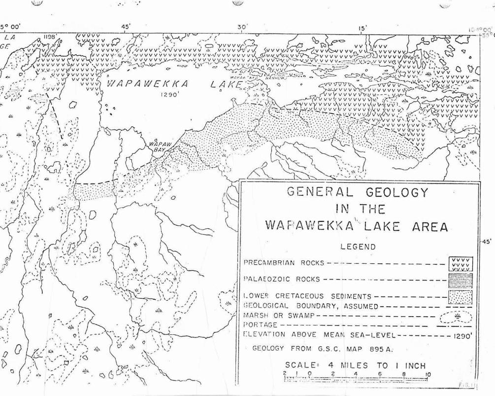
Figure 1 General Geology in t he \"!apa,·rekka Lake Area
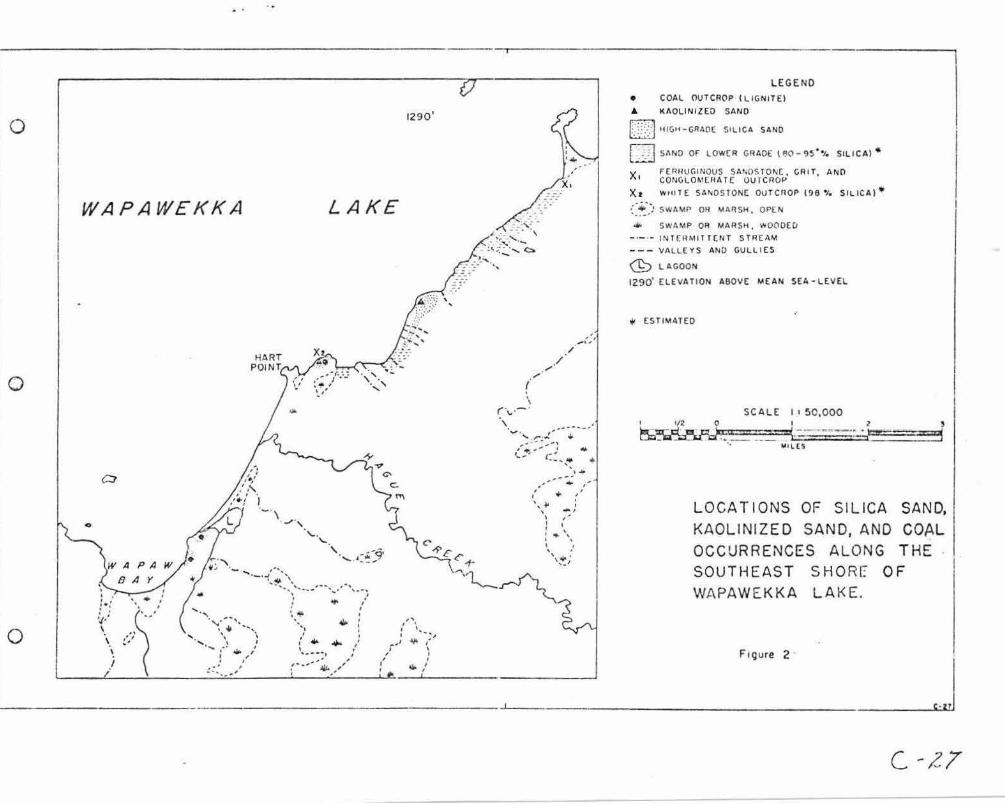
Fir;ure 2 - Locations of Si l ica Sand , Kaol ini zed Sand , and Coal Occurrences along the southeast shore of W.:.pawekka Lake •

Silica Sand c.:id Coal Occurrences c.n Wan-::i.wekka Lake ..
INTRODUC-i'I01J
Locat ion and Access
1':apawe~a Lake is located between latitudes 54° 509 and 55° 00'
Nor t h and l ongitudes 104 ° 00f and 104 ° 501 \·lest , east of the southern part
or La c l a Ronge . The coal and silica sand occurrences are exposed on the ·'
southeast shore of 1·;apawei:;:a La.J.:e , 30 to 32 a i r miles southeast. of La Ronge .
The area i s most easily accessible by float-equipped aircraft .
Ho,·;ever , Wapa~·;ek}.3. Lake can be reached by canoe from La Ronge, '.·:hich entails
travel southeasta:-ly across lac la Ronge to Nipe~.ew B:J.y , the rr:ost south-
eaat~rl y bay on Lac la Range , and fro~ there by a portage , 1.3 Biles long,
into \·~apa·,;ek.ka Lake .
The Precarr.brian S:iield 011tcro?S alo:ig the north shore of ~·:apawekka
Lake and alo:ig that part of the south s:-:.ore east of \·!apa,·rekka [s:..·ro·.·;s (Figure
1) . Sand cliffs 25 to 60 feet high occ'..ll' alor.g the southern s~ore of
'Wapawekka lake fro:n the sc:1~h end of \·:ap.w E2.y and northeasterly for a
distance of approY...:i.r.lately eight miles, except along that part of the shore
extending f r om a lagoon lccc=.ted nor-theast of l·;apaw Bay , to Hart Point . In
t his section the area lying back from tte shore is gener2.lly lo' .. ; and
swampy over an ap;:>rox:inate ,-d.dth of one-eir-hth mile (Fieure 2) :·
Erosion ha s cut steep, straig~t gullies in the sand perpe~dicular
to t he south shore . These gullies exte~d back from the shore for distances
of one- eiehth t o one- quarter mile or t':ore . The area lying to the southeast
of \·:apawekka Lake is essent-ially a large san::3 plain extending back for about
eight mil es . 'l'he pl~in r isas into the i·:apawek1ce. Hills ,-:hich f cr::1 a conspicuous -
- 2

2 - I
s outhv:esterly trending ridge 800 feet or more above the genera l level of the
, . p_am. The top of the Wapawekka. Hills is a t ableh.nd approxir..at ely 15 miles
~rid e and 35 to 40 miles long, partly occupied by muskegs. The muskegs are
due to t he lack of slope for drainage and the presence of an underlying
hard, :inpervious h.yer of shale . Numerous muskegs and swamps occupy the
general area s outh of Lac l a Ronge and \·!apawE:Jcka Lake.
Hague Creek i s the main stream flow:i."1g fro:n the southeast into
Wapal':ekka Lake appro:<..ir:.ia.teiy nidt-:ay between the south end of l'!apaw Bay and
Hart Point . Other streai11s entering the lake from the south to the \·!est of
W!\'paw Bay are 1-Jer-t Creek, ~·.'uche·.·,'U.'l River , and Yahol.r-..ite}:y Cree~ .
The body of water lying northe~st of Wapaw Bay is a lagoon separated
from the lake by a wide sand bar . The level of 1-!apawekka Lake is 1,290 feet
above mean sea- level, while tha t nf l.;l~ J.:\ Ron~~ ic: 1.,198 f~~t..
Previot.is \·!o r k
William Mcinnes of the Geological Survey o: Canada visit ed t he Lac
l a Ronge area in the autum.."1 of 1908 and su rveyed the a~·ea ir~~-:tedia.tely a round
Wapav:ekka Lake in 1909. This work i s presented in the SurrrrE.ry P.eport ·or 1909
and in Hemoir No . 30, 1913.
A r econnaissance sur vE-y of the area was carried out by W. G.
Worcester during the field seaso:is of 1920 a:1d 1921. Findinb::; of this
survey ar e described in an unpublished r.eport .
Fiel d \fork
This r eport i s based 0:1 n:appine carried out bJ· the ,-.-ritcr dm·ine
the week of August 10-11; , 1959. The area examined includes that pa rt of the
- 3

- .3 - I
south shore of Wapav;ekka Lake from the southern extremity of Wapaw Bay and
nor t heast for a distance of approx.iJ:r~ tely e1ght miles . Vertical aerial
photographs with a scale of approximately o'ne-ha.lf mile to one inch were used
a s control.
The writer wishes to ack."'lowledge the voluntary assistances of s.
·Tosi who acted as assistant in the f ield .
R~ferences
Dowling D. B., (1914) : Coal f ields of Eanitoba , Saskatchei·,an , Alberta and
E:astern British Colu;::bia ; Geol. Survey Canf.da , 1-iem. 53 , p . 86.
(1915}: Co~l f ields and coal r esources of Canada ; Geol. Survey
Canada, Ee:::1. 59, p . 68.
n-hr.H ,,, l /"l ('>t:;t:;\. p..;.-...,J, •• • " •, \ .... ,//.//•
. Saskatchc:·:a.n ; Prov. of Sask., Dept . of 1.-:i.ner al Resources, Rept . of
Investigations l!o . 7, P? · 2.3- 28 .
Hassebroek, \·J. E. , (1955) : Sand usage in hydrc.ulic fracturing oil beari:ig
formations ; pa'::)er prcse:1ted at Annual 1-:i;;eting of A. I.l-f. M, E,,
Chicago , Illinois , February 17, 1955,
Krtunbein, H. C., and Sloss , L. L. (1953): Stratigraphy and sedimentation ;
W. H, Free:?!an and Company, San Francisco , California .
Ladoo, Ray,;:ond B., (1946); revised (1948) : Industrial silica for Pacific
Northwest Industries; Ra.w },;aterials Survey , 701 \'.roodlock Bld&. ,
Portland 5, Oregon .
!.adoo, Raymond B., and Nyers , \·! . H, (1951): Non-::ietallic miner2.ls , HcGrc-;w
- Hill Book Co:!!Fnny, Inc . , l~ eH York .
Mcinnes , \-Jilli2.I'.! (1909): L?."c I.a Renee district, Saskatche,;·cn ; Geol. Survey
Canada , Stt.r:J:".ary Rcpt. , 1909, pp. 151-157 ,
. - J ' - 4

- 4 I
Mclnnes, Willia.!il (1913) : The basins of t he Nelson and Churchill River s ;
Geol . Survey Ca:1.ada , l{e:n. 30.
Saskat che..,:an Research Council (1959): Turtle LaY.e beach sands; unpublished
r eport .
Worcest er, W. G. (1921) : Reconnaissance survey of part of northern Saskatchewan;
Dept . of labour and Industries ; unpublished ~eport • .'
GErIBRAL G:SOLCGY
The general geolog-j' of the irL'Tiediate area surrounding 1,;apawek}~a
lake is sho'.·.11 i n Figure 1. Sedimentary r ocks and sed:ir:.ents of Cretc.ceous
ar.d post-Tertiar;, age are exposed alons tr.at part of the south shore of
Wapawekka L:.ke covered by this report .
The Cretaceous section is i;:~de up principally of ,·rhi te qcartz sand
a nd sandst or.e , and ferruginous sands, sandstones, grit and ccnglo~erate.
Stratigra})hically the ferrq;inous sedi:ients a.p?arently \L"1derlie the ,·:hite
sand and sandstone. Ferrugino'.:.S sandstone , grit, and conglorr,e:-:-·::.e ot,.tcrop
on t he shore at a point about four miles northeast of H~rt Point . Ferr-~-
gj.nous sands overlie these consolidated sed.irr.e:1ts and are probably derived
from t hem. Lenses and l ayers of f errugiuous sandstone occur within the
f erruginous sands .
The l arge.r porticn cf t he Crste.c.ecus section exposed alo:1g the
south shore of \·!ap,n·:ckka lake consists of white quartz sands with lesser
amounts of fcrruginous material and impure sand lenses and layers , The
sands a re gener ally loosely coherent , rese~bling r~cent deposits , but , in
some l ocalities the sands are indurated and forI:I a friable sandstone . Cn
t he point of land east of Hart Point there are thicb1esses of as much as
20 f eet of white s~ndstone exposed at tbe base of the outc:·op. In places
some unconsolidated sand occurs between beds of t he sandstone , Layers and

-5- /
·l enses of carbonaceous oaterial and ver-3 thin clay seams occur in the
~rhite quartz sands . From a point about one- half r:ule east of Hart ?oint
.and extending south'.>:est,·:2.rd, sea:ns of lig:iite occur in the white sedimentary
f'orrr:.aticn ,-:here it is exposed.
The f e~r~ginous scdi..~snts are gener ally more coarse g~c:ined and
inequigranula.r than those of the younger , white sedir.,e:it2.ry u.,::.t . The grit
i.s In2&e up of inequigranular grains of quartz and other i mpurities cer-e:ited
by i ron oxide . The conglomerc.te has a similar l!".atrix with peb:,les fro:;L one...:
e ighth inch to one-half inch in dia~ete~, which co~sist of quart~, clay
ironstone, 2..::1.d a highly altered rock) p:,ssibl y of Preca!:":brian c!'igin .
The Cretace:,us s ed::i.r.,cnts of ~·ra~awe1r..ka lake: are not found i..~ cont.act
with underlying rocks in the area rr~pped , but it i s assu.lj;cd the-t t hoy overla?
t he Palaeozoic roc%s ar.d r est direct~, u;:.on r ocks of Precc::..r:-,brian ;,.~e; ;)? rt i.cn
l arl y to th'3 east where Preca::i'.:>ric~ roci<E Ollt;::rop along the so1;.th shore
east,:.'2.rcis f :.•o::i ":!apa;·:e;.._'.(a. l:arro·.;s . According to 1-:cir.nes 11the C:-ctaceous
sedi.men:.s at the e-astern er.d of the clif:s a.re s~p:.ra.ted by an interval of
l ow l and e.bout 600 yards ,·:-.:.de; from e):;>oEur-e of mafsi ,·e hard, dar k , fine
t extured quartz diorite 11 • Ho·.-:ever , Devor,ian l ime$tor1e is reported to · outcrop
on the southeast shore near the south end of i~c la Rcnge . These sands and
s andstones are considered equi'rale:1t in age to the s,-:an River for.::~tion of
east central Sas;<atche,·:an, which is presu-:ied to be of Lc·,·rer Cretaceous age.
For t he ~ost part , drift zrE.terial of Pleis~ocenc and Recent A5e
overlies the Cretac eous s edL~ents . ~uch of the drift i s composed of
r eassorted sands derived fro~ the Cretaceous f or~ztion; \lith Prccrur~rian
b ould~rs. Accordbg to l-:cinnes (1 <;09 , l 9J.J ), boulder cl?.y, co?1tain ing boulders
of l imestone and of Precambri.:.n gr.eiss and granitic rocks overlies the
Cretaceo'Js to the south in the ',·::.p2.v:ekka Hills .
- 6
. - '6 .... /
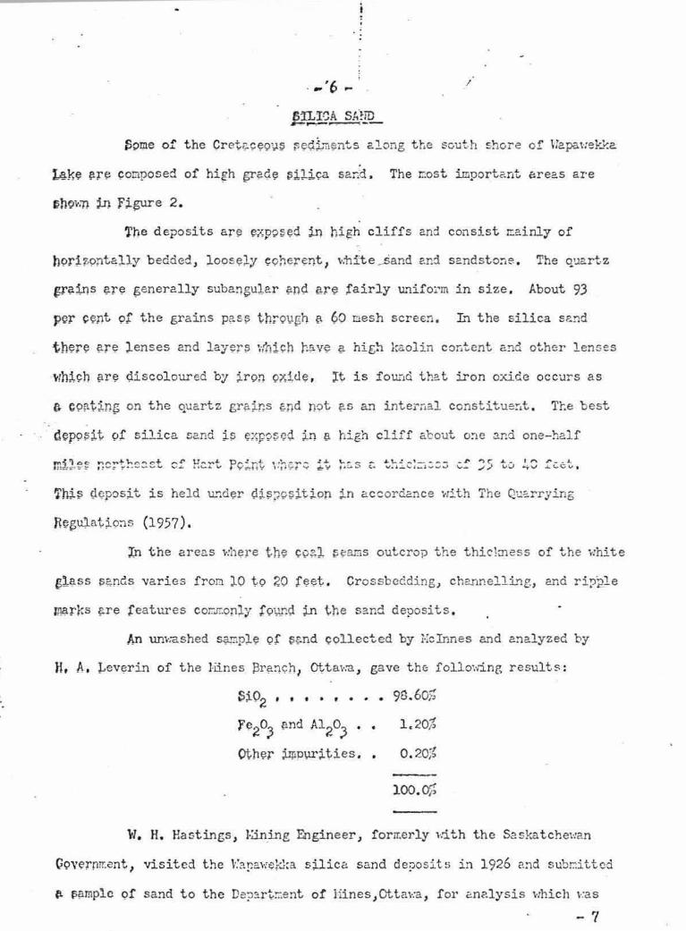
J:Ake ~r~ ~omposed of hi~h ~?-G.e ~;!J .. i~a sand. The r.:ost importc'.nt ~reas are
The deposits are ~1,posed j.n hi~h cliffs and consist reainly of
h9rti9nta;tiy bedded, loos~ly ~9herent, ~:hfte_sand e.nd sandsto~e. The q'.l2.rtz
19"?-::l-ns ?-r~ ~enerally subangul.ar ~nd ere fairly U."lifo:.·m in size . About 93
p.cr cent 9f the grains p~s;s th;ov~h ~ 60 mesh screen. L~ the silica s~nd
t h~r~ ?.r~ ;tenses and lay~r::> ~·:hi.ch r.?-v~ a. hie;!l kaolin cor,tent and other lenses
wh;l,ch ?-re d.iscoloured by j.ron QXitle , lt is fou;-1d that iron oxide occurs as
e CP~tin~ on the o.uartz gr~;ir:s &nd not ~s an internal constitue~t. Tte best
d~po;sit ot silica sand j.~ F:;{p?~CQ. JJ'l a high cliff about o:-1e and one-half
\.. .... _ - ~\....: ... , ____ ..,. I' 1;.....i..::, (.... w .. ,_~, ..... ,..,..;..J 1,,,.._
~hJ~ i;l<;pos;Lt is held u.'1d~r (lj..~~c~ttion j.n accordance with The Q~;:.:::-rying
R~~i,4at~o~s (1957).
In the areas where th~ ~9?-l ~cams outcrop the thic!mcss of the white
sl~$S ~~nds varies fron lO to 20 f~~t . Crossbccding) channelli..~g, and ri,ple
1*!-rr.s ~re features cor::..T.only f9\JI'-~ ~ tne sand deposits .
An unwashed s9.r1pl~ 9f ~g.nd ,;ollected by i·rclnnes and ana.lyzed by
H, A. Levt;!rin of the Hines :3r?.!1C::h, Ottawa , gave th(; following results :
sio2 , • • • , • • • 9a.60%
F~2o;3 ?nd Al2oJ • •
oth~r SJµp\lX~ties • •
1 .20%
0 . 20;~
100. 0%
W. H. Hastings , J.;.in_ing Engineer , foru.erly with the S2skatchewan
C9Vfrnrr.cnt 1 visited the \·.'ar,a,·;~;:}:a s;i..lica sand de:)osits in 1926 and subr:1ittcd
Ci- t,~mplc of sand to the De?~rt:::ent of Hines , Ot ta\·:a , for analysis which \·:as
- 7
-7-/
a s f ollol':s :
Che:nical Analysis
• • ::f Si02 • • • • • ·• • • • . 98 . 50r-,
• Fe2o3 _ ••••• 0. 008%
AJ..2°3 • • • • • • • • 0.21%
Screen /!..nalysi..s
Cum~lati•.'e Per Cer,t
+2S
+35
+48
+100
+200
-200
1.0
51.4
39. 7
4.1
1 .1
0 . 2
100.0
1 .0
52.4
92.1
96.2
97.3
99.8
The War...av:ek~a ciep~sits must be co.:1sidered as an import2.nt poteritial
sou!'ce of silica sand because of the appBrently large quantity a."'ld the high
grade of the sands . A drilling ?l'ograr:i would be r equir ed•·.to outline 2.."'ld
determir.e the extent of t he silica Sc!.nd deposits i:1 the area .
Appendices A, B, cl1d C give the uses of silica sand and t he
specifications f or sa:;d used in the rr.anu:facture of Blass a:-id in hydraulic
f racturing of oil-bearing forwaticns .
- 8

COAL /
Coal of the lignitic class outcrops on the ncrth s ide of the point
east of Hart Point; o~ the south side of the entrance into the l agoon 2 . 4
.miles to the southwest of Hart Point ; and again O. 44 niles further south·.·rest
on t he shore of Wapaw Bay. The .locations ot the coal outcrops are sho,·m in
Figure 2 . The section of the saao bet,·reen !fort ?oint and the lagoon, a
distar.ce of 2.bout t,·:o and one-half riiles , proba_bly has been eroded away by -glacial action .
The coal sear.i in all three locations occurs interbedded v:ith the
"White qua rtz sands e..."ld sandstone . The se&.'ll dips at a low angle to the south\..
·The greatest thick.iess of coal observed is ai)pro;d.!!i::J.tel~, four feet with a
-parting of sar.d six to eight ir.ches thick. In places the ccal seem is a
mixture of carbonaceous .. ~terial and s~nd . The seam ha s a thickness of 2 . 5
f eet \·:here it outcrops at the lagoon. In this f.)articular locality there are
· no sand partings, nor does the li£nite co:1t2.L1 any ~ ot!l"!t of int.i;r;nixed end
or clay.
Worcester (1921) during his _e;.:a....,.. ~n~tion of th e i,!a~·.·r~kka co~l seam
dug a t est pit which \':as carried '.:>c:.c% for a distance of 17 fe:et from the face
of the outcrop. The coal seam at the outcrop measured four feet one inch
with indu.rated sc>.nd above and belo·.-,, while 17 f eet back fro!'!:. the face the coal
seam is five f eet t,-:o inches thick. This test pit is now oblite;oated due to
slumping a.id infilling of the inco:1erE.nt sands.
F. G. Wait (1909) of the Hines Branch, Dei::a,rtment of Hines , Otta,·:a ,
made a pro:d..mate analysis by fast co},ing of a sanple of 1'.1a.pav:ekka lttmite and
the r esult~ wc:.s ~s follows :
Moistw·e (air dried) . . . . . . . 11.23%
Volatile Cor:;bustible l·'.::ltter • • • 30. 97%
- 9
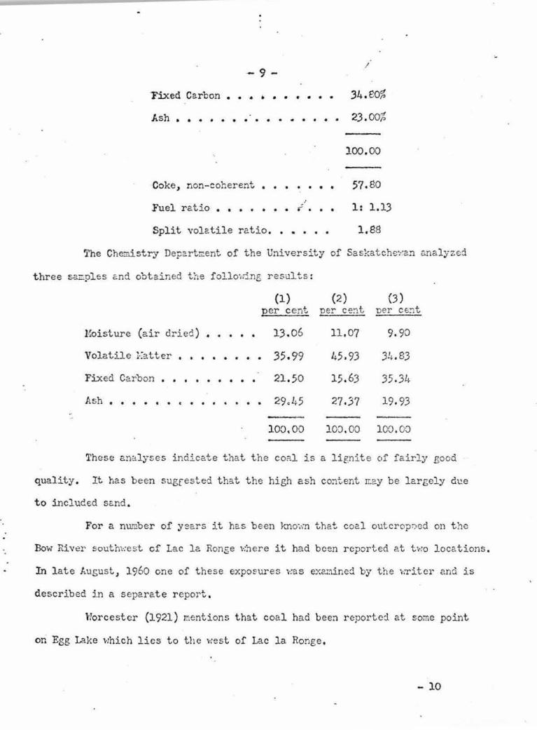
-9-
Fixed Car bon •••••• • • • •
Ash • • • • • • • · • • • • • . • •
Coke, non- coherent . • • • • • •
Fuel r atio • • . . . I
i . . .
/
34. eO%
23 . 00%
100. 00
57. 80
1: 1.13
Spl it volatil e ratio . • • • • • 1. 88
The Chemistry Depart!::!ent of the University of Saskatche~··an rmalyzed
t hree s~ples end obtained the follovring r esults :
(1) (2) (3) per cent per ce~t ner C€~t
Moi sture (air dried) . • • • • 13.06
Volatile Eatter , ••••••• 35,99
Fixed Carbon . • • • • • • • • 21.50
Ash , • • • • • c • • • •
100. 00
11.07
45,93
15. 63
27,37
9. 90
34.83
35 .34
19, 93
100 . 00 100 . 00
These an~lyses indicate tha t the co;:i.l is a lignite c,f fairly good
quality. It has been sugrested that the high ash cotltent rr2.y be largely due
t o included s~nd.
For a number of years it has been knm,m that coal outcrop;-;,ed on the
Bow Rh•er south,·:est cf Lac la Ronge ,·:here it had been reported at two locations .
In l ate J..usust , 1960 one of these expo~ures ,-:as examined by the ,-.Titer and is
d escribed in a separate report .
Wor cest er (1921) mentions t hat coal had bee:-1 r eported. at some point
on Egg Lake which l ies to the west of Lac la Ronge,
- 10
- 10 - /
The former Industrial Hinerals Research Branch of the Department
of Mineral P.esources p-:--ospected for coal in t h e 1-'.acKen-z.ie Creek area south
west of lac l a Ronge. A prospect trench, about ten feet deep, \',as cut on
the north side of an e:ast-:·1est trendine; ridge, on the south sic:.e of 1-:.acY.enzie
Creek, approxir.lately 300 yards east of mile 6?i of the La Ro:1ge High·,·:ay (Ko . 2) .
Two t hin coal seams v:ere exposed, one f o~r in<;)Ies thick at a depth of four
! set , eight inches , and the other six inches thick at a de?th of six feet .
Coal seams have been encountered in bore holes on the east side of
Montreal lake in Ls<l 2-5-61-21.- ~·12 and at the sout.h e;id of the 1£.ke i.1 Lsd
3-4-59-25-~·!2. In the former drill hole, thouf.h in spite of poor recovery
of drill cuttings , the geolof.ists in cha.rte estin:a t ed there was a 14-foot
coal-be:a.ri.'"lg zone in the interval fron 630 to 650 f eet , In the ,:Gll at the
southern e:;,:tre::uty of l·'.ontrel!l Lake a 30-fnot coal-bearing z0ne ,.;:ii; Pi!Co11pt .P-r(";0
at an approx ir.a te depth of 720 feet . Coa l sea!iiS also have bee~ e~co1..i..1tered
at clepths of 600 f eet or more in the 1-:eadow Lake, Big River , ar.d C:1oiceland
areas .
The c oal outcrops on Wapewekka 1.2.ke themselves are not of e:co1101:iic
importance but are significant v:hen considered along ,d. th the other coal
outcrops, and occurrences at depth, in that they may indicate the northern
edge of a coal field lying to the so-:.1.th , southHest, and ,-:est of v:ap~,-:ekka lal.."e .
Further surface geological ·.-:ork is unlikely to r eveal more infor;:1ation but ~
i:r.ogram of drilling ,,·ould b e necess5.ry to prove the presence of such a coal
field, as ,-:ell as the depths a t ,·:hich the coal occurs .
Appendix D gives the Canadian classification of coal by ran.1< .
11
-.
• : - ll ~ /
Aopendi.x A
Silica sand has been used for many years in a large number of
manufacturing industries. The various industries require sand of different
physical properties and che~~cal purity .
Uses for Silica Sand*
Abrasive Uses _, ..,.
In scot!I'ing and polishing soaps and powders.
In sand pa.per .
In sand-blast i·:ork.
For saHing and polishing r2.rble, granite, etc.
As lithographer's graining sand.
Wood polishing and fini$ni~g
In too:.h powders ar1d nastes.
}fetallu.r.rdc.al Uses
In t::a.king silicon, ferrosilicon ~.nd silicon alloys or other minerals.
Found!'Y p2.rtine sand and :mold He.sh .
Cherr:ical Ind~stries
As filtering ~ediu.a,
In manufacture of sodi~a sili~ate.
In manufacture of silicon carbide .
Pct5nt
As an ine~t extender .
* After ladoo and 1-~yers (1951)
- 12

-12 - I
lfuieral Fillers
As wood filler •
.ln f'ertilizers .
In insecticides.
As filler in r ubber and other molded goods .
In road asphalt surfacing mixtures . j
In t he potteiy i.'1dustry as an ingredient of bodies gl azes a:1d
enamels .
In the manufacture of glass .
Structural !-:':.tsrials
Sand-lin:e brick.
Refr~~1:.rirv lJ,;P. s - .
For sand surfacing molds .
As setting sand in kilns to prevent ,·:are fro::. stickir1g .
Hydraulic Fracturing of Oil-Bearing Fon::ations
Specifications for Sand in Glass }:.anufc.cturin,g (After LRdoo .. Lccd00 a:1d ; ;:vers)
For the manufacture of high quality, clear, colourless glass
containers, silica sand m~st be very lOi{ in iron and all other i mp~rities ,
such as clay, silt, a:1d organic r.-.atter which cloud the glass c?.r.d 1:;ay cause
black specks . Usually an acceptable sand runs over 9S. 5 per c ent Si02
, with
n ot over O~ 0!1- per cent Fe2o3; Al2o3
ma.xi.r:m:n O. 5 per cent ; CaO and lf,€0 maximun
O. 2 per cent ; and Ti02 t:?-'d1mw1 o. 03 per cent. These requirer:1~nts a r e not
a l ways strictly adhered to, esnecially the Al2o3
m?.xir:.um. Since ah:mina is
used in container el~ss batches, a sn:B.11 au1ount of Al2o3
in the batch rr.ay b e
- 13

-13 /
allowed if it can b e held uniform. Too high an alu.m.na content in the sand
makes it iopossible to build up a prooer batch mixture . It is also important
t hat the feldspar conte:1t have unifor;n ra.tios of Ka2o, K20, and Cao.
For coloured glass con~ain~:::'s higher iron Eay be tolerated, especially
if it is f airly 1L'1iforr.1, but l ow iron is preferred.
Sand should be of such grain size th~t all will paes through a
20-=iesh sieYe with not over 5 per cent f iner than 100 nesh. One glass conpa:1y
·states "scr::e tolerance cm be allo·,,:e:d in the f iner sizes ; however, the Di.nus
100 ~esh fraction should not exceed 20 per cent . In the best s a~d, the bulk
of "the produc~ lies bet~·:e::m 26 c>.nd l5 raesh . Un~o::-mity of grain size and
shape are ir.:iporta:1t f or proper oeltin·g . Coarse sand r equires toe high a te.':'.t-
perature and too r:u~h ti."'.'!e for ft:sio:1 .::.:1d! very fine sand ;;-:ay be c2.rried 2·.-:ay
"balls up 11 and c,n1scs •:seccs11 and sis'T.ilar il:lperfections in the g;.ass . Grain
shape p:::-obc.bly is not particularly imp::>rtant, but there are some advocates
. of vell-ro'..l..'!'lded erai."ls , v:hile so:i.e gla$S m:inufc..ctures pre.!'er grains of angule.:::'
shape, for su~h sands melt nore readily than those of ,-rell rour.1de:i grains .
Glass sands rr.ust be thoroushly dried before use .
The f.ational Bureau of Standards and the Ar:terican Cera!ilic Society
proposed standard spccific?.tions for glass sand . These were not generally
accepted or used by i.'1dustry, but arc of valuB t.o indicate general tewlencies .
These specifications are r;i ven :in tr:e followine tc:ble .
- 14

. - 14 -
Table I . Proposed Chenic~l Rcc;.uirement3 f or Gl e:;s Sand*
(Specif i cation formulated by the /\mer icnn Cer~mic Society in connection with Bur eau or Standards)
Calcitun and Silica (Si02 ) Alumina (/\~03) Iron Oxide (Fc2o
3) Jlhgncsium . -- ..
(CnO + Mr,O) ---Cualitics of Gla~s Min .. ~ Tol~r~r11..:c JI' ,:! Tl f.(•\V % Tolernncc f·\1.X , % 'folcr ance "l~ o. cr.ince ,~ --~·: First quality optical glass 99.8 + 0.1 0.1 + 0. 05 0~02 + O.OJ5 0 .1 + 0.05
s~cond quality flint gl ass 98 . 5 + 0. 5 0 . 5 + 0.1 0.035 + 0. 005 0 .2 + 0 .05 contair.~rs, t ~blc~ar e
Third quali ty flint elass 95.0 + 1.0 h.O + 0.5 0.035 + 0 .005 0 . 5 + 0.1
Fourth qual ity sheet ela~s , 98 .5 + 0. 5 0 . 5 + 0 .1 0.06 + 0 .005 0 . 5 + 0.1 rolled :ind polished plate .
Fifth qu~lity sheet 0lass, 95 .0 + 1.0 4.0 + 0.5 0 . 06 + 0.005 0. 5 + 0.1 roDcd and polished plate
Sixth quality green elasa 98.0 + 1.0 0 . 5 + 0.5 0.3 + 0. 05 0. 5 + 0.1 contai..,~rs and wirnio• . .,, c;ll'.ss .,
Seventh quality r,rccn r.l~ss 95 .0 + 1.0 L~ . O + 0. 5 0 .3 + 0,05 0 . 5 + 0.1
Eiehth quality amber gla~n 98. 0 + 1.0 0 . 5 + 0. 5 1.0 + 0.1 0.5 + 0.1
Ninth ~unl ity ~~bcr gl~ss 95 .0 + 1.0 h.O + 0.5 1.0 + 0.1 0 . 5 + 0.1
* After Ladoo and ¥orers .
- 15

- 15 I
Appendi.x C
Hydraulic Fracturin~ of Oil Bearing For~~tions
(After Hassebroek (1955) and Saskatche,,.!an Research Council (1959)
The purposes of hydraulic fracturing of oil bearing formation is
t o increase production rates from a well by -generating new and greater
effective perme~bility. In the earlier work on fracturing, viscous fluids,
generally a gelled hydrocarbon, were used alone to fracture the forITztion.
Only in rare cases did this result in sustained production increases . Ehen
a prop'.)ing agent such as sand is 2.dded to the viscous fluid , it keeps the
created fracture open after pressure is released a~d the production rate is
perffianently increased.
The fracturing is carried out by pu..:p:.r..g a suspension cf sar.d in
viscous fluid into a fluid-bearing forrr:ation under sufficient pressure to
overcor:.e overburden ,-:eight, thus creating a parting or fracture \·d.th in the
f ormation. As pumping continues the fractcre is e:1le.rged e.nd extended a,·:ay
from the point of entry , °t'!hen pressure is relessed and a gel b:-eaking a.ge!1t
i s added, the treating fluids and formation fluids flo· .. , into the bore hole e.!1d
t hen to the surface. The proping afent keeps the fracture from closing and'
provides a highly permeable drainage channel .
Early fracttU·ine treatr.,ents consisted of relatively s.ru.11 vol1.1:-nes of
materials , but the qu~ntities used have increased in recent years . For
exampl e, t he average a~ount of fracturing fluid per treatment increased from
800 gallons in 1949 to 6, 600 gallons at the end of 1954 . Over the same
period, t he ave:-age sand weight increased from 350 to 9 , 800 pou..'Ylds . The
quantity of sand per treatments varies from 1, 000 to 200,000 pounds .
- 16

- 16 - /
Sands f or use as a pro9ping agent should have the following
propert ies :
1. They should be rounded in sh~pe.
2. They should have a minim~~ variation in size .
3. They should be as large in diameter as can be placed
pract ically within the forr3.t5:9n being fractured. - .
4, They should have a high co:r,pressive strength .
5. They should be free of dust and silt .
Spherical particles have an adv.s.ntage over angular grains of equal
size in th2.t they provide greater packed p';:rmeability. Angular grains are
more difficult to place in for7.1.2..tions. The sharp corners have a tendency to
l odge against obstructions and interlock ,-:i thin the!7:sel ves, thus restricting
t he fi·ee rolling action within a frt.cture, exhibited by rounded grains . This
l eads to a bridging actio~ in the hole, in the subsurface tools , and in the
f racture . For use in hydraulic fracturing, sand s!:ould !-:ave a roundness factor
of 0.6 or above . The degree of rou.~dness has been defined by Krw,£ein and
Sloss (1953) as the ratio of the average r.:ldius of curvatu:res of the several
corners and edges to the radi~~ of the lareest inscribed circle on t he
projected image of the sand grain .
If t he sand part icles have a minimum variation in size , flow
caoacities through them decrease uniform.ly as the compressive l ead increases .
If the sands have a wide size range the floH cap.a.city decreases rather
sha1'ply as the lo.ad increases . kpparently unequal supporting action alloHs
excessive permeabi lity . Typcial allo1·:2.bl e variation would be 10-30 mesh or
20-40 mesh. In the literature· no mentio;-i is rrade of sand lar!_:er than 10 mesh
- 17
l ,. !
-17 -/
or sI2.ll.er th.an 60 mesh being used in hydraulic fracturing .
Low compressive strength c:.nd the presence of dust a:.1d silt \·!ould
lead to objectiom.ble n:aterial v,hich ,-:ould plug the passage in the fracture
and decrease the permeability!
APPendix D
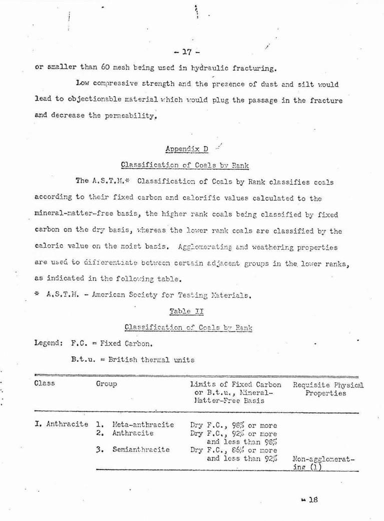
Classificat:i.cn cf Coals by Rank
The A.S.T.H.* Classific~tio:i of Coe.ls by Rank classifies co&.ls
according to their fixed c2rbon ~nd calorific values calculated to the
mineral-~atter-free basis, the higher rank coals being classified by fixed
carbon on t:1e dry basis, .. :hereas the l o,·1er r ank coals are classified by the
caloric value on the m0ist basis . Afg:o~8~ating end weathering properties
are u~ecl to ciiii erentir.:.te bct·.:c::cn cert,=.in adjE'.cent groups in the. l o-.·1er ranks,
as indicated in the f 0110° .. :i.ng table.
* A.S.T. H. - A.inerican Socj_ety for Tes:.ing 1-:::.terials .
Table II
Classification of Coals by Rank
Legend : F . C. = Fixed Carbon.
B.t . u. = British ther~al units
Cle.SS Group
I. Anthracite 1. 2.
3.
Eeta-ar.thracite Anthr2.cite
Semiant.hracite
Limits of Fixed Carbon or B. t.u., 1·j_!'lerall iatter-;<":-ee 13.?.sis
D ... C 98~ ry r • • , i~ or more Dry F. C, , 92;...( or r.1ore
and less t h~n 98% Dry F. C., 66~; or r.:ore
and less th:1n 92%
Req'..lisit e Physical Properties
.Non-acglo::1erat ing (1)
14 18

..
II Bituminous 1.
2.
Li.
III Subbitura- 1 . . inous
2.
3.
-18 I
Table lI cm~T ~D
Low volatile bitu.-.1i.nous coal Mediu."':J. volatile B bitu:r..inous coal High volatile A bituminous coal
High volatile B bituminous cca l High volatile C bituminous coal
Sub bit t:.."Jinous A coal
Subbitu:'d.no't!S B coal
Sub bit '..:..7.inous c coal
' .
~ F.C. , 78% or ~ore and less than 86J; (.3) Dry F. C., 69% or ~ore aLd less than 78% (3) D~y F.C., less than 69% and noist (2) B.t . u . 14,000 (L}) or rr:ore 1-;oist (2) B. t . u . 1.3 ,000 or core and le~s than 14s000 l-:oist 13. t.u. 11,000 or more , l ess than 13,000 (4)
Eoist B.t.u, 11 , 000 or zricre and less than 13,000 (4) l:oist B.t . u. 9, 500 or :nore and less than 11,00) (4) i.:oist B.t . u . S,300 er ~ore a~d ltss t h~n 9,500 (4)
Either agglo~-... . era.,1.ng or no:i-weather:.ng (5)
Both \-:e<lthering and non-afglc=.erating .
IV Lignitic 1. Lignite l{oist B.t.u . less t h?.n Co:isol:°ldated
(1) (2)
(3) (4)
{5)
8,300 2. Bro,·m coal Hoist B.t . u . less tr.an UnconEolidate::1
8,30J
If· agglo:ierating, classify in lo·.-:-Yolatile grou? of bitur:-..inous class. l:oist B. t . u . :-efers to coal cont-2:•·1ing its natural b ed n::oisture bu~ not including visible ,,:ater on surface of the CCl?. l.
There cay be non-caking Yarieties in each group of the bituminous class . Coe.ls having 69;~ or t:?re fixe;o carbon o:i the d.r-.f, mi.nerc.l-~.atter- free basis shall be classified accorclir:g to fi.J.:ed carbon re6ardless of B. t.u. There are three varieties of coal in the high-volatile C bitu.":j_nous coal group, namelJ•, Vad,et.y l; ?.eel0;,, 0 rc2.t.ing 2..11d non-Hoather2.ng; Ve.riet:r 2, ageloraerating and i·1eathering; Variety 3 , non-c:.&:glo::crating and. nonweathering.
' I
l \ I l 1 \ Lf.t \ - I
,', .. "'; (,~' ,. ' .
. ,
I I , _. l
' : · .. ;
C)
~ I ..... .
12 901 n
' t
,-..,"J \ t '
' ' ' ,,1, .. ' . ' ' ', /
GE NE1~AL GEOLOGY IN THE
WA Fi A Vif E K K f-\ \. __ L A K E AREA LEG END
vvvv PRECC\MBRIAN ROCKS - - - - - v vvv '.)LjLJ/,
f>ALA EOZOIC ROCKS-------- ·---- --- -----1*;=:.::; I. OWER CRE TACEOUS SEDIMEN TS - - - - - - - - - - [-/\:)]
(,EOLOGICAL BOUNDARY, ASSUMED - - - - - - - - - _: ~ ·..:..·-:::_
r·t1ARSH OR SWAMP- ---------------- .' .... -~ - ~'. ' -- ..,., ...... _ .,. ,
P Of.~ T AGE - --- - - - - - - - - - - - -- .:_ __ -
f: LEV/\"'" ION ABOVE MEAl\l SEA-LEVEL - - - -- - - - - 1290'
GEOLOGY FROM G.S . C. MAP 895 A :
SCALE: 4 MILES TO INCH 2 r o 2 4 6 a ro 1, ... , ' -- - · , '- - · ------·---, -- ---1--- - ~·-·=:::j r·,··· ·~ .. l , . .... --- - -.,.;·- · . · ~. · .• .. . . ·----- i.-·· ...... ~ - ---
·-·---- ----- - - ----:..r.:.•.:::.:...:...:' !
45'
0 1290'
WAPAWEKKA LAKE
0
I . . .,
. . • . . . . ...
~·
, : . ·,/ ,
0 \ .. '.
. , ~-\
/
;'
(
, '
\ r ·v-·
\ ·-· ,,--~- ... -· ,': ·-:--;-; ... , ..
(J-,'' (: ) .. -...... ,~ .. ....
,,,.#'- ~ ,' ,' ..... ; , ' • .j< •
' .... ' I ,' : I ... \ . . ~ )
"~~~;
LE GENO • COAL OUTCROP C UG NIT El ~ KAOLINIZED SAIIO
[ }:::] IIIGll-GRAOE SILICA SANO
t ·-"I SANO OF LOW(R GR AD[ 1130- 95· ·,. SILICA! •
XI
I'( IHIUGINOUS SM,()$ TONC CR IT A NO CONCLOMtHA TE OUfCROf• '
Xt W!HTE SANOSTONC OUTCROP l98 "I. SILICA)•
( ~ ) S WI\\IP OR MARSH, OPE N
... SWAMP OR MARSH . w oOOEC,
-·-· - IN T( IIMII TCNT STREAM --- VALLEYS AN O GULLIES
© LAGOON
1290' ELEVAT ION ABOVE ME AN SEA - LEVEL
;, ESTIMATED
L OCATIONS OF SILICA KAOLINIZED SANO, AND OCCURRENCES ALONG
' i
SANO, COAL T HE
SOUTHEAST SHOR[ LAKE .
OF WAPAWEKKA
C-l-7