significant winter storm - weather.gov · weather forecast office presentation created follow us on...
TRANSCRIPT

Weather Forecast Office Presentation Created
3/20/2018 4:42 PM Follow us on Twitter Follow us on Facebook
Winter Storm Warning now in effect for
eastern Suffolk County
Snowfall amounts increased for Long
Island and southeast Connecticut
Significant Winter Storm
Decision Support Briefing #3
As of: 4:30 PM Mar 20, 2018
New York, NY 1
What Has Changed?
Current Hazards
Weather Forecast Office Presentation Created
3/20/2018 4:42 PM Follow us on Twitter Follow us on Facebook
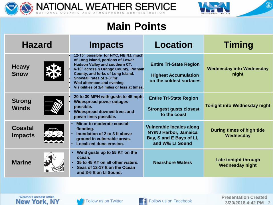
Main Points
Hazard Impacts Location Timing
Heavy
Snow
Strong
Winds
Coastal
Impacts
Marine
• 12-15” possible for NYC, NE NJ, much
of Long Island, portions of Lower
Hudson Valley and southern CT.
• 6-10” across n Orange County, Putnam
County, and forks of Long Island.
• Snowfall rates of 1-3”/hr
• Wed afternoon and evening.
• Visibilities of 1/4 miles or less at times.
• 20 to 30 MPH with gusts to 45 mph.
• Widespread power outages
possible.
• Widespread downed trees and
power lines possible.
• Minor to moderate coastal
flooding.
• Inundation of 2 to 3 ft above
ground in vulnerable areas.
• Localized dune erosion.
• Wind gusts up to 55 KT on the
ocean.
• 35 to 45 KT on all other waters.
• Seas of 12-17 ft on the Ocean
and 3-6 ft on LI Sound.
Entire Tri-State Region
Highest Accumulation
on the coldest surfaces
Vulnerable locales along
NY/NJ Harbor, Jamaica
Bay, S and E Bays of LI,
and W/E LI Sound
Nearshore Waters
Wednesday into Wednesday
night
Tonight into Wednesday night
During times of high tide
Wednesday
Late tonight through
Wednesday night
New York, NY 2
Entire Tri-State Region
Strongest gusts closest
to the coast

Weather Forecast Office Presentation Created
3/20/2018 4:42 PM Follow us on Twitter Follow us on Facebook
None Limited Elevated Significant Extreme
Summary of Greatest Impacts
None Limited Elevated Significant Extreme
None Limited Elevated Significant Extreme
None Limited Elevated Significant Extreme
Heavy Snow: Entire Tri-State Region
Strong Winds: NYC Metro, LI, Coastal CT and Westchester
Coastal Impacts: Vulnerable locales along NY/NJ Harbor,
Jamaica Bay, S and E Bays of LI, and W/E LI Sound
Marine: Nearshore Waters
New York, NY 3
Weather Forecast Office Presentation Created
3/20/2018 4:42 PM Follow us on Twitter Follow us on Facebook
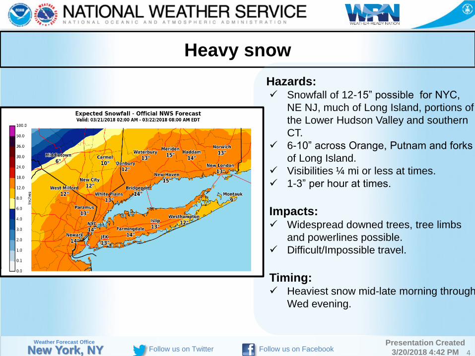
Heavy snow
New York, NY 4
Hazards: Snowfall of 12-15” possible for NYC,
NE NJ, much of Long Island, portions of
the Lower Hudson Valley and southern
CT.
6-10” across Orange, Putnam and forks
of Long Island.
Visibilities ¼ mi or less at times.
1-3” per hour at times.
Impacts: Widespread downed trees, tree limbs
and powerlines possible.
Difficult/Impossible travel.
Timing: Heaviest snow mid-late morning through
Wed evening.

Weather Forecast Office Presentation Created
3/20/2018 4:42 PM Follow us on Twitter Follow us on Facebook New York, NY 5

Weather Forecast Office Presentation Created
3/20/2018 4:42 PM Follow us on Twitter Follow us on Facebook
Coastal Flooding
New York, NY 6
Coastal Flood Hazards and
Impacts: Minor to Moderate coastal flooding.
Inundation of 1 to 2 ft above ground
in vulnerable areas.
2-3 ft above ground for south
shore of western Long Island.
Shoreline Hazard and Impacts: Localized dune erosion.
Timing: During times of high tide
Wednesday and Wednesday night.
*Coastal Flood Watch for Wednesday night for south shore Bays of NYC and Western Long Island

Weather Forecast Office Presentation Created
3/20/2018 4:42 PM Follow us on Twitter Follow us on Facebook
Onset Time
New York, NY 7
Approximate Onset Time
Weather Forecast Office Presentation Created
3/20/2018 4:42 PM Follow us on Twitter Follow us on Facebook 8
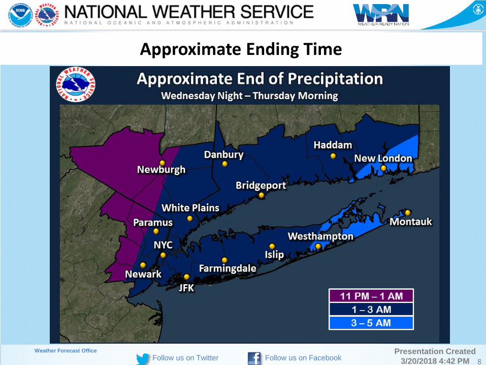
Approximate Ending Time
Weather Forecast Office Presentation Created
3/20/2018 4:42 PM Follow us on Twitter Follow us on Facebook 9
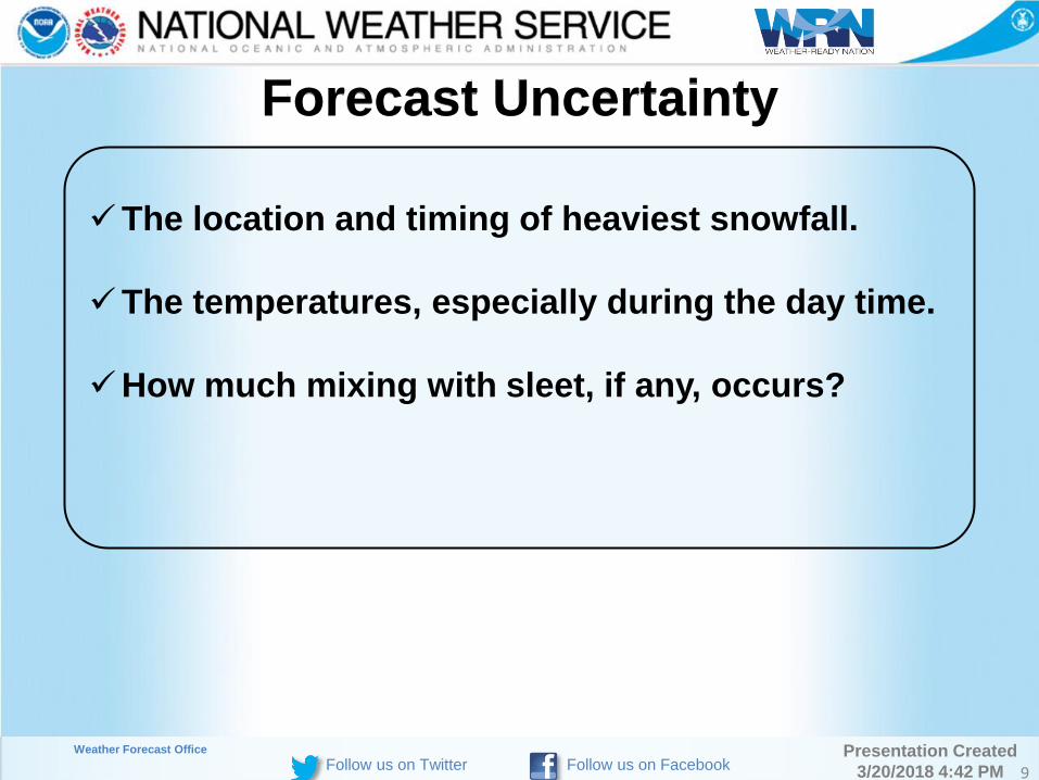
Forecast Uncertainty
The location and timing of heaviest snowfall.
The temperatures, especially during the day time.
How much mixing with sleet, if any, occurs?

Weather Forecast Office Presentation Created
3/20/2018 4:42 PM Follow us on Twitter Follow us on Facebook
Event Summary
10
Accumulating heavy, wet snow and gusty winds could cause
widespread power outages and widespread tree damage.
Near blizzard conditions possible across coastal Connecticut
and Long Island.
Snowfall rates 1 to 3” per hour, especially late Wednesday
morning through Wednesday evening.
Hazardous travel possible developing during the Wednesday
morning commute and becoming nearly impossible for the
afternoon and evening commute.
Minor to moderate coastal impacts with Wednesday high tide.
Weather Forecast Office Presentation Created
3/20/2018 4:42 PM Follow us on Twitter Follow us on Facebook
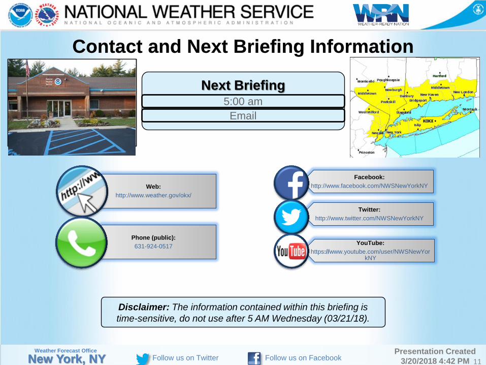
Contact and Next Briefing Information
Next Briefing
5:00 am
New York, NY 11
Web:
http://www.weather.gov/okx/
Phone (public):
631-924-0517
Facebook:
http://www.facebook.com/NWSNewYorkNY
Twitter:
http://www.twitter.com/NWSNewYorkNY
YouTube:
https://www.youtube.com/user/NWSNewYorkNY
Disclaimer: The information contained within this briefing is
time-sensitive, do not use after 5 AM Wednesday (03/21/18).