sightseeing the alps in a c172 - homepage j¶rg emmerich
TRANSCRIPT

Sightseeing the Alps in a C172This tour will guide you to many of the most famous mountains, valleys, glaciers, snowfields, winter and summer vacation areas, etc. in the European Alps. In addition there are several hints to visit nearby areas of interest. On the tour you will visit Switzerland, Italy and France.
Simulating a C172 in 12.000 feet close to high mountain-peaks present some new challenges! e.g. watch out for “blue sky turbulences”, especially near rims and peaks. And do not forget to readjust your Gyro Compass after heavy turbulences, because my course directions are given as indicated magnetic bearings.
The following description is based on FlightGear (with ATLAS) but works also for the MS-FSX. If you try it on both you will discover the superior scenery/terrain-details of the FlightGear!
You need scenery e000n40. See an ATLAS overview of the flight by clicking on Part-1 from Buochs to Visp, this one takes about 50 Min. in air and Part-2 from Visp to Geneve, this one takes about 60 Min. in airI suggest to set the visibility to 30 miles (if your system allows). Other parameters you may see in my Startup-cmd-file and weather settings..
Synonyms inside German names:
German/Swiss English Category Marked like:
..see lake Water Name
..pass, ..luecke
..horn, ..spitz
..gletscher, ..firn
passage, rimpeakglacier, snowfield
Mountains Name(meter-feet)
..tal valley Name
..stadt, ..dorf city, village Villages Name
Markings in the following flight description : marks flight-instructions and the general course. I suggest an altitude of 12,000 feet.• marks additional sightseeing informations
ref: marks an interesting link into the Internet. Additionally you may find almost any of the named mountains, villages, etc. in the Internet (e.g. wikipedia.org)dev: marks an interesting/possible deviation from the proposed tourText with yellow background marks changing VOR settings and/or a quick indication of the actual position, like e.g. “MOT 27.5 NM”. The later defines the indicated distance in miles form the VOR MOT (frequencies are given in the 2nd column of the table). In these cases the VOR-radial is of no importance (assuming you are in the described valley on the defined course!).
By the way: I am not involved in the tourism business – I am just a German Fan of beautiful landscapes (and Flight-Simulators).
If you do have problems, proposals, questions, comments, etc. → please contact me: [email protected]
Sightseeing the Alps in a C172 2009-01-30 page 1 / 12
Buochs
(country = Switzerland)
(Kanton “Nidwalden”)
N46°58’15 E08°23’24
VORs:KLO 114.85FRI 110.85
~80° START at Buochs (LSMU-07R) towards Riggi-Scheideck(1662-5453) (in MS-FSX: LSMU=LSZC)
follow the Vierwaldstaettersee (= “Lake Lucerne”) to the right start normal climbing to 12000 feet. VOR FRI will start indicating above 3500.
• If you are bored looking on water, watch the parade of mountains on the right and left. dev: Just NW across the lake is Luzern. Further north you find Zuerich, VOR KLO 114.85ref: http://www.airportbuochs.ch/index.php?lang=english (or German)ref: http://en.wikipedia.org/wiki/Lake_Lucerne (or ..//ge.wiki..)
Brunnen
(Kanton “Uri”, probably the most known Swiss Kanton (in crossword-puzzles))
N46°59’11 – E08°34’10
KLO 114.85 176° from 27.9 NMFRI 110.85 078° from 57.0 NM
~170° Follow the bending of the lake to the right (now called Urnersee) towards Amsteg via Altdorf etc.
ref: http://en.wikipedia.org/wiki/Canton_of_Uri • At the inside corner of this bend you see Seelisberg with the mountain-meadow “Ruetli”, the
legendary place of the “Ruetlischwur”. That is comparable to the declaration of independence in the USA (1776) – but already in 1291! The source of many stories all over Europe and all the pride of the Swiss people (besides banking)!!!
ref: http://en.wikipedia.org/wiki/Ruetlischwur • Straight ahead, at the end of the valley is Mt.Bristen(3072-10079)• you are now following the E35 towards Italy . That is the Europe-Highway 35, from Amsterdam
in the Netherlands (North-See) via Germany and Switzerland all the way to Rom (Italy, Mediterranean See). There you expect lots of vacation traveling!
ref: http://en.wikipedia.org/wiki/European_route_E35• from KLO 34.0 NM you see far to the left the Sandalppass between the very dominant peaks of
Schaerhorn(3.295-10,810) and Toedi(3614-11857)• from KLO 37.8 NM: If you are above 7000 you can watch the peak of Mt. Titlis(3238-10326)
wandering across a nice valley, guarded by the Great- and Small- Spannort.• half left in the distance there appears the peak of Mt. Oberalpstock(3328-10919)
ref: http://de.wikipedia.org/wiki/Oberalpstock• directly left of Amsteg is the Mt. Windgaellen(3188-10459)
Amsteg N46°46’19 E08°40’07
KLO 114.85 172° from 41.4 NMFRI 110.85 089° from 59.9 NM
~225° continue to Wassen, keeping the Mt. Briston(3072-10079) on your left• straight aheadp you see already the Rohnegletscher (the spring of the Rhone-river) with Mt.
Galenstock(3583-11755), etc.ref: http://en.wikipedia.org/wiki/Rhone
Wassen N46°41’44 E08°36’21
KLO 114.85 176° from 45.8 NMFRI 110.85 095° from 57.5 NM
~195° Andermatt via Goeschenen-Pass(2318-7605)dev: Over Wassen you could turn to 290° following the valley Meiental via the
Sustenpass(2224-7297) towards Brienzersee etc. (See similar at Furkapass)dev: Andermatt is in the 2nd valley after Wassen! The 1st one heads directly across the
Rohnegletscher. you could try that by turning to 260° at KLO 47.5 NM, but be sure to be well above 10.000 feet! We then meet again over the Grimselsee.
Sightseeing the Alps in a C172 2009-01-30 page 2 / 12

Andermatt N46°38’34 E08°36’02
KLO 114.85 178° from 49.6 NMFRI 110.85 099° from 57.4 NM
~256° • Just about 3 miles east of Andermatt is Rossbodenstock with the spring of the Rhein.
Furkapass(2431-7975) keep the Rhonegletscher (quell of the Rhone-river) on the righ.• half way the very dominant Finsteraarhorn(4274-14022) will appear (see picture), just left of
the Rhonegletscher.ref: http://de.wikipedia.org/wiki/Rhonegletscher (sorry – under “..//de.wiki..” there are much nicer
photos and descriptions! Of course you may switch to English!)dev: Over Andermatt you could turn into the valley of the (very young) Rhein at about 70°. You
then would get via the Oberalppass(2044-6706) to Chur, Lichtenstein, and finally to the Bodensee in Germany.
dev: About 3 NM after Andermatt you could turn left, continuing to follow the E35 towards the St.Gotthard-Pass(2108-6916) towards Ariola and Lake Magiore and Milano in Itally
Furkapass
(Kanton “Wallis”)
N46°34’20 E08°24'38
MOT 115.85 246° to 40.8 NMFRI 110.85 103° from 51.0 NM
~270° ref: http://de.wikipedia.org/wiki/Furkapass (sorry: on ..//en.. there are less text and pictures!)
lake Grimselsee thru Grimselpass(2165-7103)dev: If you are not above a very minimum of 9500 feet at this point you better do not go through
the Grimselpass to the lake, but follow the Rhone-valley at the left of the Mountains left of the lake (at ~235°). We then meet you again in Visp, see further down. (Compare ATLAS 1)
dev: Over the Grimselpass you could take the valley of the Aare (at ~325°). You then reach the Brienersee and Thunersee and the cities of Meiringen, Brienz, Interlaken, Spiez, Thun, and finally Bern.
• The Furkapass marks the east/west watershed in Europe (e.g Rhone → west, Rhein → east)ref: http://en.wikipedia.org/wiki/Rhine ; http://en.wikipedia.org/wiki/Rhone
• The Grimselpass is one of the earliest south/north paths through the Alps used by human beings
From above lake Grimselsee
(Kanton “Bern”)
N46°33’52 E08°19’02
MOT 115.85 244° to 37.0 NMFRI 110.85 106° from 47.0 NM
(Mouse-Click to size up)
~275° dev: If you are in a hurry, you could instead of following the 7 items below follow the Oberaargletscher (the valley at the left side (see pink “dev.” arrow in picture)) leading directly to the passage just left of the Finsteraarhorn – after that you cross the Jungfraufirn and head straight towards the valley to the Loetschenluecke. (See next table-item).
Visiting the Virgin and her Monk (compare picture on the left)ref: http://en.wikipedia.org/wiki/Jungfrau
1. follow the Unteraargletscher on 275° just between Hinder Stock (3307-10845) right and Scheuchzerhorn(3452-11325) left
2. at MOT ~33.0 NM follow the Finsteraargletscher to the left on 245°, straight towards the dominant Finsteraarhorn(4274-14022). Follow the higher glacier directly beneath the Finsteraarhorn to the right
ref: http://en.wikipedia.org/wiki/Finsteraarhorn3. then steer ~290°, alongside the Fiescherhoerner4. at ~MOT radial 237 follow the glacier Fieschergletscher at ~280° towards the
rim between Moench (monk) (4099-13448) left and Eiger(3970-13025) right. stay close to the Eiger. (The rim is 11800 feet – so you might wish to be a little above 12000 feet!!)
Sightseeing the Alps in a C172 2009-01-30 page 3 / 12

• If you have time above the rim, look straight ahead: In 4 NM there is Wangen with the Lauberhorn (2472-8110), you may know it from the FIS Worldcup Skiracings.
dev: You also could go outside around the Eiger - but that's boring!5. over the rim (~MOT 26.1) turn sharp left to 220°, then around the Moench to
~135°, passing through the Jungfraujoch(3475-11401, watch your altitude)• keeping the Jungfrau (virgin) on our right(4158-13642).
6. Follow the Jungfraufirn until intercepting Radial MOT 240°.• This is a famous area for summer-skiing.• Passing Fiescherhoerner and Gruenhorn, now on the left.
7. turn right between Gletscherhorn(3983-13068) left and Dreieckhorn (3811-12503) right.• Follow the Radial MOT 240°, i.e. the “Aletschfirn” towards the Lötschenluecke into the
Lötschental• Just behind yourself you may see again the dominant Finsteraarhorn.• Directly at the left of the Loetschenluecke is the Aletschhorn(4195-13743)
Loetschenluecke
(Kanton “Wallis”)
N46°28’27 E07°57’47
MOT 115.85 240° to 21.4 NMFRI 110.85 120° from 38.6 NMp
~245° VispFollow the Langgletscher into the valley Loetschental. On the way you may look for the following mountains:
VOR MOT from ... NM
On the left On the right
~21.4 Aletschhorn (4195-13743) Grosshorn (3762-12343)
~20.0 Schinhorn (3797-12457) Breithorn (3782-12408)
~17.6 Nesthorn (3824-12546) Birghorn (3243-10640)
~16.0 Bietschorn (3934-12907) Sackhorn (3212-10538)
~14.5 Wilerhorn (3307-10850) Hockenhorn (3293-10804)
~13.8 Hohgleifa (3279-10758) Rinderhorn (3454-11332)
At MOT 12.4 NM turn to 180°Dev: If at this point you turn to 310° instead, you reach the famous FIS world-cup skiing area of
Adelboden after about 10 NM. intercept radial MOT 94° from towards the east.
dev: Before Visp you may take a break at SION (VOR SIO 112.15 (just a little behind VOR MOT), LSGS at 1578 feet, Rwy 8L-26R, Twr. 118,275) (see picture Part 2)dev: If you descent early enough, you could also take a coffee just before Visp at Turtmann (LSTA, 2051 feet, Rwy 09-27, VOR-MOT from 90° at 13 NM). Then starting in LSTA• and continuing to Zermatt may become interesting, because you probably have to circle over Zermatt in order to climb to 12000 feet prior to heading for the rim!!• or dev: You could follow the valley to Brig (MOT 20.0 NM at 90°) and turn to ~150°, following the E62 (European Highway, ref: http://wapedia.mobi/en/European_route_E62 )
via the Simplonpass(2005-6578), passing the Lagginhorn(4010-13156) to Italy and the Lago Maggiore with Ascona, Locarno, etc. You then could follow latitude 46° eastward heading for Lago di Como via Lago di Lugano. Finally you could land in Lugano (LSZA, 912 feet, Rwy 01-19, Twr. 119.7, VOR LUG 111.50) – or other famous cities. But caution: Finding your (simulated) way across the Simplonpass is a little tricky! You need a good chart and always know exactly where you are!!
Sightseeing the Alps in a C172 2009-01-30 page 4 / 12
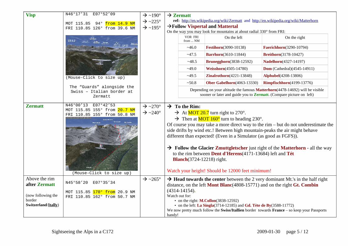
Visp N46°17’31 E07°52’09
MOT 115.85 94° from 14.9 NMFRI 110.85 126° from 39.6 NM
(Mouse-Click to size up)
The “Guards” alongside the Swiss – Italian border at
Zermatt
~190° ~225° ~195°
Zermatt ref: http://en.wikipedia.org/wiki/Zermatt and http://en.wikipedia.org/wiki/Matterhorn
Follow Vispertal and MattertalOn the way you may look for mountains at about radial 330° from FRI:
VOR FRIfrom ... NM
On the left On the right
~46.0 Festihorn(3090-10138) Faerichhorn(3290-10794)
~47.5 Barrhorn(3610-11844) Breithorn(3178-10427)
~48.5 Brunegghorn(3838-12592) Nadelhorn(4327-14197)
~49.0 Weisshorn(4505-14780) Dom (Cathedral)(4545-14911)
~49.5 Zinalrothorn(4221-13848) Alphubel(4208-13806)
~50.8 Ober Gabelhorn(4063-13330) Rimpfischhorn(4199-13776)
Depending on your altitude the famous Matterhorn(4478-14692) will be visible sooner or later and guide you to Zermatt. (Compare picture on left)
Zermatt N46°00’13 E07°42’53MOT 115.85 155° from 20.7 NMFRI 110.85 155° from 50.8 NM
(Mouse-Click to size up)
~270° ~240°
To the Rim: At MOT 20.7 turn right to 270°. Then at MOT 160° turn to heading 230°.Of course you may take a more direct way to the rim – but do not underestimate the side drifts by wind etc.! Between high mountain-peaks the air might behave different than expected! (Even in a Simulator (as good as FGFS)).
Follow the Glacier Zmuttgletscher just right of the Matterhorn - all the way to the rim between Dent d'Herens(4171-13684) left and Tét Blanch(3724-12218) right.
Watch your height! Should be 12000 feet minimum!
Above the rim after Zermatt
(now following the border Switzerland/Itally)
N45°58’20 E07°35’34
MOT 115.85 170° from 20.9 NMFRI 110.85 162° from 50.7 NM
~265° Head towards the center between the 2 very dominant Mt.'s in the half right distance, on the left Mont Blanc(4808-15771) and on the right Gt. Combin (4314-14154).Watch out for:
• on the right: M.Collon(3838-12592)• on the left: La Singla(3714-12185) and Gd. Tète de By(3588-11772)
We now pretty much follow the Swiss/Itallien border towards France – so keep your Passports handy!
Sightseeing the Alps in a C172 2009-01-30 page 5 / 12

Just after the rim between right Gd.Combineand left Gd.Tète de By
N45°54’08 E07°14'12
MOT 115.85 203° from 27.0 NMFRI 110.85 180° from 52.6 NM
~255° Towards Mont Blanc(4808-15771), the highest mountain in the Alps and 2nd
highest in Europe! Higher is only the Elbrus(5642-18510) in the Russian Caucasus.
Intercept MOT 218° From and follow it into the valley towards south.
dev: From this rim you also could turn to 310° into the valley of the Drance, to eventually hit the Rohne-valley with Martigny, St.Maurice, and finally Montreux at the Genever See.
In the valley east of Mont Blanc
N45°46'38 E06°52’58
MOT 115.85 218° from 41.3 NMGVA 115.75 310° to 42.5 NM
~310° to the rim between on the left Dome du Miage(3671-12044) and on the right Mont Blanc(4808-15771)
ref: http://en.wikipedia.org/wiki/Mont_Blanc dev: You could follow the valley, cross the St. Bernadino Pass to Aosta, Italy, Milano, etc.dev: 22 Miles south from here is Val d'Isér, another famous FIS Worldcup Skiing area.
Rim betweenDome du MiageandMont Blanc
(entering “France”)
N45°49’24 E06°48’51
MOT 115.85 224° from 41.2 NMGVA 115.75 312° to 38.5 NM
~325° Cut between les Dents Blanches(2752m) right and les Avoudrues(2666-8747). Start descend, not below 6500. Intercept Radial GVA 302° to Geneve (at ~24 NM)
• Have a look backward to the Mont Blanc: It looks even more impressive from this side.!dev: You could make a steep descend to land in LFHZ ( Mt.Blanc, 1755 feet, Rw. 35-17, no Tower
etc.). But I like to land in Cointrin like all the political and banking big-shots. May be even do some ILS-training at LSGG.
On radial VOR GVA 302°
Geneve is again in Switzerland
N46°02’43 E06°48’50
GVA 115.75 302°
LSGG at 1411 feetATIS = 124.75Tower = 118.70
ILS/DME 05L = 110.90ILS/DME 23R = 109.90
Radial 302°
Follow the Radial to Geneva Airport International Cointrin After passing Mt.les Molè(1869-6132) (GVA 15.8 NM) you may descend to
2500. Do not misinterpret the LFLI (Annemasse) with LSGG. Cointrin is on the other side of the lake!
ref: http://en.wikipedia.org/wiki/Geneveref: http://en.wikipedia.org/wiki/Geneva_Cointrin_International_Airport for general Infos
and http://worldaerodata.com/wad.cgi?id=SZ35465&sch=LSGG for details.
Sightseeing the Alps in a C172 2009-01-30 page 6 / 12

Sightseeing tour on ATLAS Part 1: Buochs to Visp
Sightseeing the Alps in a C172 2009-01-30 page 7 / 12
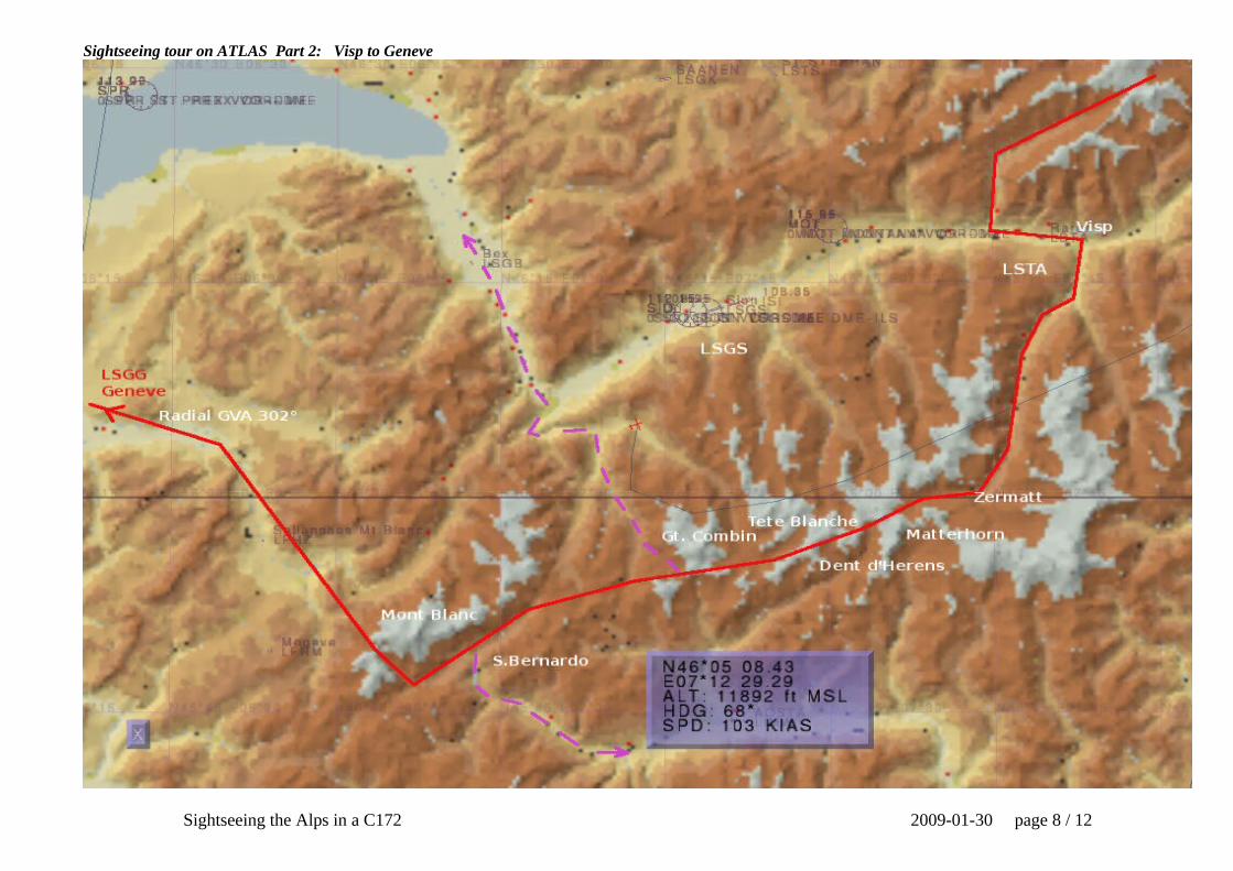
Sightseeing tour on ATLAS Part 2: Visp to Geneve
Sightseeing the Alps in a C172 2009-01-30 page 8 / 12

Sightseeing tour: Visiting the Virgin
Sightseeing the Alps in a C172 2009-01-30 page 9 / 12

Sightseeing tour: Italian border-guards at Zermatt
Sightseeing the Alps in a C172 2009-01-30 page 10 / 12

Sightseeing tour: The Matterhorn Pass through
Sightseeing the Alps in a C172 2009-01-30 page 11 / 12

My FGFS-Start-File (I use UBUNTU)
#!/bin/bash
fgfs --aircraft=c172p \--prop:/sim/sound/voices/enabled=true \--airport=LSMU \--runway=07R \--com1=119.625 \--com2=118.7 \--nav1=178:114.85 \--nav2=078:110.85 \--dme=nav2 \--heading=80 \--nmea=socket,out,0.5,,5500,udp \--enable-sound \--httpd=5400 \--log-level=info \--enable-fullscreen \--fog-disable \--disable-real-weather-fetch \--visibility-miles=30 \--start-date-sys=2009:01:01:10:00:00 \--callsign=JE111 \
The Weather Conditions during my Flights (= Standard settings)
Compare: FlightGear Menu → Weather → Weather Conditions
Sightseeing the Alps in a C172 2009-01-30 page 12 / 12