sidi agareb (sag) project part of the chorbane permit, tunisia
TRANSCRIPT
CHORBANE
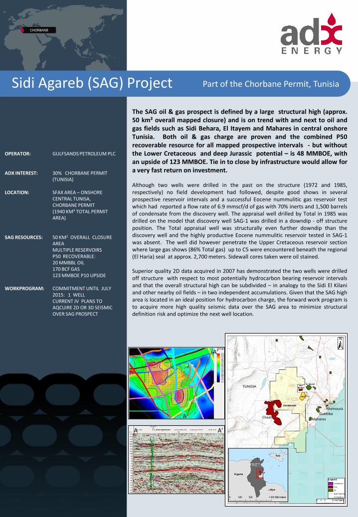
The SAG oil & gas prospect is defined by a large structural high (approx. 50 km² overall mapped closure) and is on trend with and next to oil and gas fields such as Sidi Behara, El Itayem and Mahares in central onshore Tunisia. Both oil & gas charge are proven and the combined P50 recoverable resource for all mapped prospective intervals - but without the Lower Cretaceous and deep Jurassic potential – is 48 MMBOE, with an upside of 123 MMBOE. Tie in to close by infrastructure would allow for a very fast return on investment. Although two wells were drilled in the past on the structure (1972 and 1985, respectively) no field development had followed, despite good shows in several prospective reservoir intervals and a successful Eocene nummulitic gas reservoir test which had reported a flow rate of 6.9 mmscf/d of gas with 70% inerts and 1,500 barrels of condensate from the discovery well. The appraisal well drilled by Total in 1985 was drilled on the model that discovery well SAG-1 was drilled in a downdip - off structure position. The Total appraisal well was structurally even further downdip than the discovery well and the highly productive Eocene nummulitic reservoir tested in SAG-1 was absent. The well did however penetrate the Upper Cretaceous reservoir section where large gas shows (86% Total gas) up to C5 were encountered beneath the regional (El Haria) seal at approx. 2,700 meters. Sidewall cores taken were oil stained. Superior quality 2D data acquired in 2007 has demonstrated the two wells were drilled off structure with respect to most potentially hydrocarbon bearing reservoir intervals and that the overall structural high can be subdivided – in analogy to the Sidi El Kilani and other nearby oil fields – in two independent accumulations. Given that the SAG high area is located in an ideal position for hydrocarbon charge, the forward work program is to acquire more high quality seismic data over the SAG area to minimize structural definition risk and optimize the next well location.
OPERATOR: GULFSANDS PETROLEUM PLC
ADX INTEREST: 30% CHORBANE PERMIT (TUNISIA)
LOCATION: SFAX AREA – ONSHORE CENTRAL TUNISA, CHORBANE PERMIT (1940 KM² TOTAL PERMIT AREA)
SAG RESOURCES: 50 KM2 OVERALL CLOSURE AREA MULTIPLE RESERVOIRS P50 RECOVERABLE: 20 MMBBL OIL 170 BCF GAS 123 MMBOE P10 UPSIDE
WORKPROGRAM: COMMITMENT UNTIL JULY 2015: 1 WELL CURRENT JV PLANS TO AQCUIRE 2D OR 3D SEISMIC OVER SAG PROSPECT
Part of the Chorbane Permit, Tunisia Sidi Agareb (SAG) Project
Mahares
Rhemoura
Chaal Guebiba A
A’
A’ A

Sidi Agareb Asset Highlights
Proven target depths range from 2,100
to 3,100 meters. New amplitude
supported play at 1,500 meters.
DST tested gas resource (6.9 mmscf/d)
with inerts in SAG-1 in Basal Lutetian
limestone reservoir.
Strong gas shows in the Ypresian and
throughout the Cretaceous during
drilling
Both SAG wells drilled outside P90
closure areas in relation to any of the
mapped reservoir intervals, but proved
hydrocarbon migration
Large upside in additional Lower
Cretaceous and Jurassic reservoirs.
Proximal (25 km) to the city of Sfax,
local infrastructure, strong market and
pricing conditions
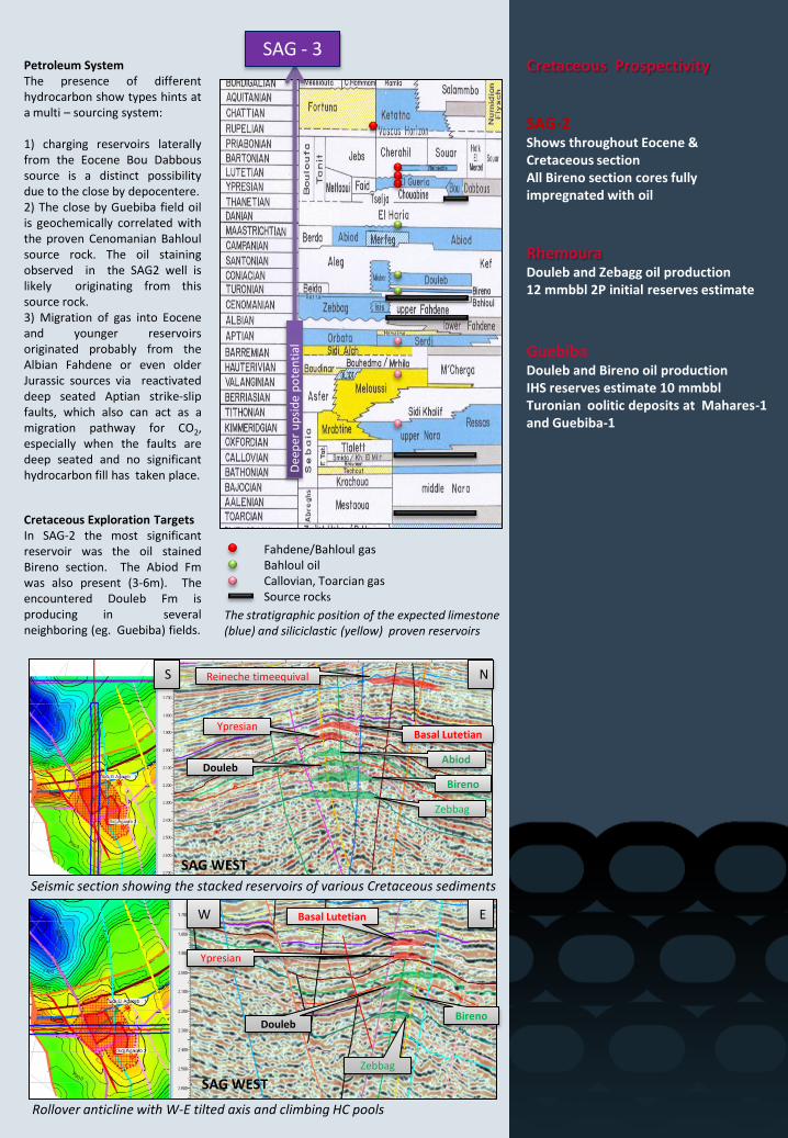
SAG area tectonic and stratigraphic framework The Sidi Agareb (SAG) structure is a result of the intersection of an old W-E directed Aptian strike-slip zone and a NNW-SSE directed Oligocene-Miocene normal fault-system reactivated by recent strike-slip movements. It has a good regional expression (~50km2 area) over a 2-3km thick sedimentary section. Deep seated faults probably released CO2 into the youngest reservoirs sections, retaining hydrocarbon fluids in deeper reservoirs, as evidenced by Eocene condensate production from the SAG-1 well. Given the large extent of the structural closure and the polyphase tectonic history it is possible that compartments with different fluid contacts and/ or different hydrocarbon compositions exist. The high levels of inerts (70%) inferred from the off structure SAG-1 well test might be attributable to only locally existing deep seated faults and elsewhere the CO2 concentration at the shallow Eocene reservoirs might be different. Within structural closure the CO2 might be completely absent due to hydrocarbon emplacement in analogy to the on trend Mahares oil field. The large semi-regional SAG structure is divided into several structural compartments. In the conservative P90 case the SAG high area would actually consist of two separated accumulations. Also, because the structure is fairly asymmetric, younger reservoirs such as the Reineche and the Oligocene sands appear as off structure with respect to the mapped Cretaceous closures.
The deepest well of the area, SAG-2 (TD @ 3276 meters TVD kb), provided a complete record of the Upper Cretaceous-Neogene sediments. Deeper reservoir intervals may however add considerable upside to the hydrocarbon potential of the area. Several reservoir intervals may have restricted areal distribution, like the Early Santonian Douleb, the Turonian Bireno or the Ypresian Metlaoui carbonates, probably controlled by a major NNW-SSE normal fault which also defines the western limit of the prospect area. This could add a stratigraphic component. In the Early Santonian-Bireno interval a platform-margin can be interpreted on the deeper seismic reflectors visible on the 2007 high quality 2D data.
P90 closure at different reservoir levels
Basal Lutetian Depth, both wells off structure
Gas
Resource
P90 bcf
Gas
Resource
P50 bcf
Gas
resource
P10 bcf
Oil
Resource
P90
mmbbls
Oil
Resource
P50
mmbbls
Oil
Resource
P10
mmbbls
Oc sands 15 40 105
Late Lutetian - Reineche equival. 20.5 50.5 124
Early Lutetian - ~Carapace 10 32.8 104
Ypresian - El Garia A+B 14.5 45 140
Abiod 0.7 1.8 4.9
Douleb 1.8 3.8 7.9
Turonian Bireno 6.9 14.6 30.9
TOTAL 60 168.3 473 9.4 20.2 43.7
El Gueria A+B
SAG-East
SAG-West
Cretaceous Prospectivity
SAG-2 Shows throughout Eocene & Cretaceous section All Bireno section cores fully impregnated with oil
Rhemoura Douleb and Zebagg oil production 12 mmbbl 2P initial reserves estimate
Guebiba Douleb and Bireno oil production IHS reserves estimate 10 mmbbl Turonian oolitic deposits at Mahares-1 and Guebiba-1
Petroleum System The presence of different hydrocarbon show types hints at a multi – sourcing system: 1) charging reservoirs laterally from the Eocene Bou Dabbous source is a distinct possibility due to the close by depocentere. 2) The close by Guebiba field oil is geochemically correlated with the proven Cenomanian Bahloul source rock. The oil staining observed in the SAG2 well is likely originating from this source rock. 3) Migration of gas into Eocene and younger reservoirs originated probably from the Albian Fahdene or even older Jurassic sources via reactivated deep seated Aptian strike-slip faults, which also can act as a migration pathway for CO2, especially when the faults are deep seated and no significant hydrocarbon fill has taken place.
Reineche timeequival
Basal Lutetian
Abiod
Bireno
Douleb
Zebbag
Ypresian
Basal Lutetian
Bireno Douleb
Zebbag
Ypresian
W E
N S
Seismic section showing the stacked reservoirs of various Cretaceous sediments
Rollover anticline with W-E tilted axis and climbing HC pools
Cretaceous Exploration Targets In SAG-2 the most significant reservoir was the oil stained Bireno section. The Abiod Fm was also present (3-6m). The encountered Douleb Fm is producing in several neighboring (eg. Guebiba) fields.
The stratigraphic position of the expected limestone (blue) and siliciclastic (yellow) proven reservoirs
Fahdene/Bahloul gas Bahloul oil Callovian, Toarcian gas Source rocks
SAG - 3
Dee
per
up
sid
e p
ote
nti
al
SAG WEST
SAG WEST
Chorbane
Gas Prone Paleogene Target
Highlights
Several Paleogene reservoirs spread over the whole SAG structure, but with offset crestal positions. DST tested Basal Lutetian reservoir (Nummulitic “El Gueria”) Fracture porosity in the lower part of the Lower Lutetian dolomites and limestones Flow Rate: 6.9 mmscf/day “Gasoline” (C5-C10) produced according to well completion report: 1,500 barrels/day Oligocene sandstone reservoirs: Presence of possible DHI encourages testing a new play type in the area
ADX Energy Limited | ABN 50 009 058 646
Registered and Principal Office Suite 6, 2nd Floor, 11 Ventnor Avenue, West Perth WA 6005
Technical Office Kundratstrasse 6/2/1, A 1100 Vienna, Austria
ADX Contacts:
Wolfgang Zimmer Ian Tchachos Managing Director Chairman +43(0)676 358 1214 +61(08)9226 2822 [email protected]
Paul Fink Technical Director +43(0)676 358 1214 [email protected]
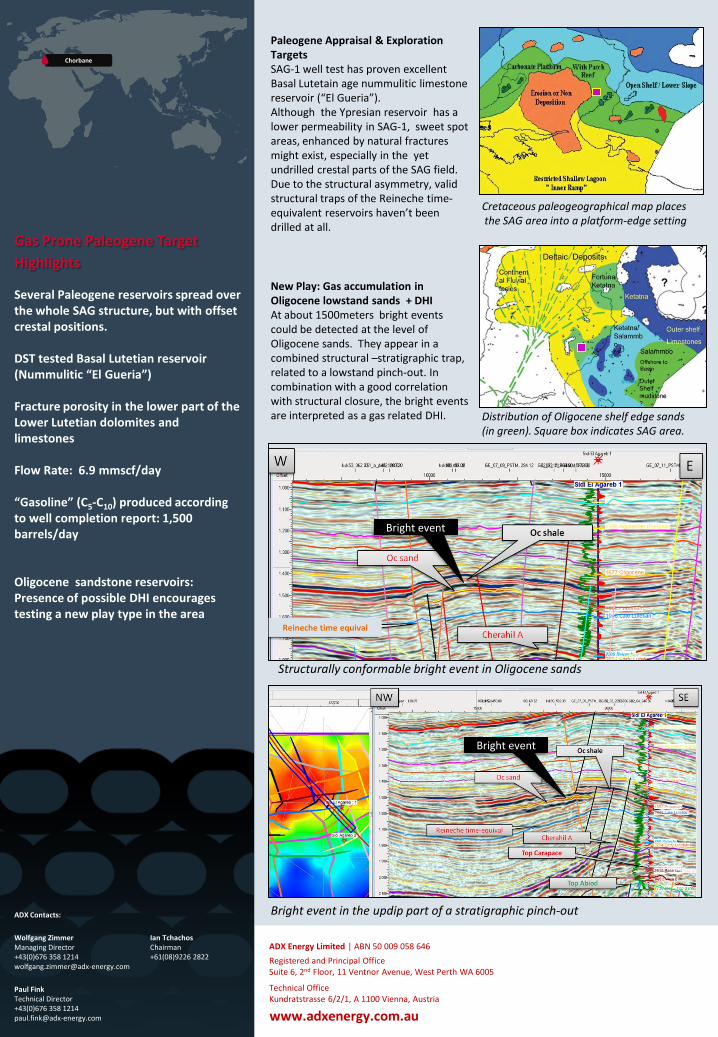
Paleogene Appraisal & Exploration Targets SAG-1 well test has proven excellent Basal Lutetain age nummulitic limestone reservoir (“El Gueria”). Although the Ypresian reservoir has a lower permeability in SAG-1, sweet spot areas, enhanced by natural fractures might exist, especially in the yet undrilled crestal parts of the SAG field. Due to the structural asymmetry, valid structural traps of the Reineche time-equivalent reservoirs haven’t been drilled at all.
New Play: Gas accumulation in Oligocene lowstand sands + DHI At about 1500meters bright events could be detected at the level of Oligocene sands. They appear in a combined structural –stratigraphic trap, related to a lowstand pinch-out. In combination with a good correlation with structural closure, the bright events are interpreted as a gas related DHI.
www.adxenergy.com.au
Bright event
Bright event
Structurally conformable bright event in Oligocene sands
Bright event in the updip part of a stratigraphic pinch-out
Cretaceous paleogeographical map places the SAG area into a platform-edge setting
Distribution of Oligocene shelf edge sands (in green). Square box indicates SAG area.
Reineche time equival