shire of mount magnet - western australian … of mount magnet... · the shire of mount magnet...
TRANSCRIPT

SHIRE OF MOUNT MAGNET
LOCAL PLANNING STRATEGY
BACKGROUND REPORT
This document provides background information in support of the Local Planning Strategy
Part Title Page 1 State and Regional Planning Context 1 2 Location and Settlements 3 3 Climate 8 4 Population 9 5 Education Facilities 11 6 Social Statistics 11 7 Aboriginal Sites 12 8 Tourism 13 9 Land Availability 13 10 Shire Facilities and Amenities 15 11 Transport Facilities 15 12 Servicing Issues 17 13 Geology 18 14 Environment 20
JUNE 2013
CONSULTANTS IN PLANNING,DESIGN AND MANAGEMENT
(WA) PTY LTD A.B.N. 77 665 477 168
_____________________________________________________________________________________________________ PLANWEST (WA) Pty Ltd Shire of Mount Magnet Local Planning Strategy - Background Report
Page 1
1 STATE AND REGIONAL PLANNING CONTEXT 1.1 State Sustainability Strategy The State Sustainability Strategy (2003) establishes a sustainability framework containing principles, visions and goals. It seeks to ensure that sustainability is considered and incorporated into decisions and actions for the future of Western Australia at all levels. It should underpin future planning for the Shire of Mount Magnet. 1.2 State Planning Strategy The State Planning Strategy was released in 1997 and describes the following vision for the Mid West Region: In the next three decades, the Mid West Region will continue to diversify its economic base in the areas of agriculture, minerals development, downstream processing of commodities and tourism. Geraldton will develop as the largest regional centre north of Perth, offering a wide range of facilities and attractions. The following strategies and actions have been identified as the first steps in achieving this vision. Strategies identified to realise the vision include:
• Identify environmental areas which could be protected as regional open space under statutory region schemes which might not otherwise be so protected. (WAPC, WRC)
• Continue to review management plans for tourist areas in or near conservation areas to protect them from degradation. (CALM) • Protect culturally significant places through town planning schemes. (HCWA, LG)
• Identify and protect water resources in the region for future population and economic growth needs. (WRC)
• Include appropriate strategies for rangeland management in the Mid-West Regional Planning Strategy. (WAPC, AgWA)
• Coordinate the provision of services such as schools, hospitals, recreation facilities, child care facilities, and aged services. (WAPC)
• Provide improved education and training facilities within the region. • Improve health services to the region. • Promote opportunities for economic development. • Implement transport strategies such as the Mid-West Regional Transport Strategy, when completed,
(Transport, MWDC), Roads 2020 Strategies and the Additional Funding Program for roads. • Facilitate the development of “one stop” shared/common government offices in small centres which
would otherwise not have direct access to such services. (MWDC, Government Agencies) • Facilitate the development of priority regional communication requirements. (MWDC) • Coordinate and provide services to small and remote settlements. (MWDC, WAPC) • Promote the retention and further development of “telecentres” to enhance regional economic
opportunities and service delivery in rural areas. (MWDC) 1.3 Mid West Regional Strategy (MWRS) To date the WA Planning Commission has not indicated that a regional strategy will be prepared for the Mid West. 1.4 State Planning Policies State Planning Policies (SPP) are prepared and adopted by the WA Planning Commission. The WA Planning Commission and local governments must have due consideration for these policies when making decisions on planning matters. The following State Planning Policies are relevant to the Shire of Mount Magnet: SPP 2 Environment and Natural Resource Planning This is a broad policy that is supported by more specific policies. It details guiding objectives for water resources, air quality, soil and land quality, biodiversity, agriculture and rangelands, minerals, petroleum and basic raw materials, marine resources and aquaculture, landscapes, greenhouse gas emissions and energy efficiency.

_____________________________________________________________________________________________________ PLANWEST (WA) Pty Ltd Shire of Mount Magnet Local Planning Strategy - Background Report
Page 2
SPP 2.4 Basic Raw Materials While this policy is not specific to areas outside of Perth and adjoining areas, the main objectives of identifying and protecting the location of land for the extraction of basic raw materials is relevant to the Shire of Mt Magnet. SPP 2.5 Agriculture and Rural Land Use Planning The main objective of this policy is to protect productive agricultural land from activities that will threaten its productivity, whilst acknowledging a need to accommodate urban expansion and other important uses. The SPP established a number of objectives for planning in agricultural areas including the following.
1. Protect agricultural land resources wherever possible by: (a) discouraging land uses unrelated to agriculture from locating from locating
on agricultural land; and (b) minimising the ad hoc fragmentation of rural land; and (c) improving resource and investment security for agricultural and allied
industry production. 2. Plan and provide for rural settlement where it can:
(a) benefit and support existing communities, and (b) have access to appropriate community services and infrastructure.
3. Minimise the potential for land use conflict by: (a) providing adequate separation distance between potential conflicting land
uses. (b) introducing management requirements that protect existing agricultural land
uses; (c) identify areas that are suitable and capable of intensive agricultural pursuits
as agricultural priority areas; and (d) avoid locating new rural settlements in areas that are likely to create conflict
with established or proposed agricultural priority areas.
SPP 2.9 Water Resources This policy aims to protect, conserve and enhance water resources that have significant economic, social, cultural and/or environmental values. It also aims to assist in ensuring the availability of suitable water resources to maintain living environments, while maintaining or improving water resource quality and quantity. SPP 3 Urban Growth and Settlement This is a broad policy that is supplemented by more specific policies. It details guiding policy measures for creating sustainable communities, managing urban growth across Western Australia, planning for liveable neighbourhoods, coordinating services and infrastructure, managing rural-residential growth and planning for the Shire particularly in relation to historic townsites. SPP 3.1 Residential Design Codes The Residential Design Codes detailed in this policy assist with planning for residential development. This policy is incorporated in all Western Australian town planning schemes, requiring Council's to have regard to its content when considering approvals for residential development. 1.5 Draft Country Sewerage Policy This policy although in draft form has been endorsed by State Cabinet and forms part of the recognised planning framework. The main objective of the draft Country Sewerage Policy is to protect public health.

_____________________________________________________________________________________________________ PLANWEST (WA) Pty Ltd Shire of Mount Magnet Local Planning Strategy - Background Report
Page 3
2 LOCATION AND SETTLEMENTS The Shire of Mount Magnet covers an area of 13,877 square kilometres with its closest border located about 415 kilometres north northeast from Perth - as the crow flies. The Shire is about 145 kilometres wide and 160 kilometres deep. The townsite of Mount Magnet is located 562 kilometres from Perth (via Wubin), 290 kilometres north of Wubin and 80 kilometres south of Cue and 194 south of Meekatharra. The Shire is bounded on the north by the Shire of Cue, on the west and south by the Shire of Yalgoo and to the east and south by the Shire of Sandstone. The Shire has 202 kilometres of sealed roads with over 827 more kilometres remaining unsealed. Figure 1 shows the location of the Shire and townsite in relation to the surrounding shires and the Perth Metropolitan Region.
FIGURE 1 - LOCATION PLAN Source: NatMaps, Landgate & PLANWEST
_____________________________________________________________________________________________________ PLANWEST (WA) Pty Ltd Shire of Mount Magnet Local Planning Strategy - Background Report
Page 4
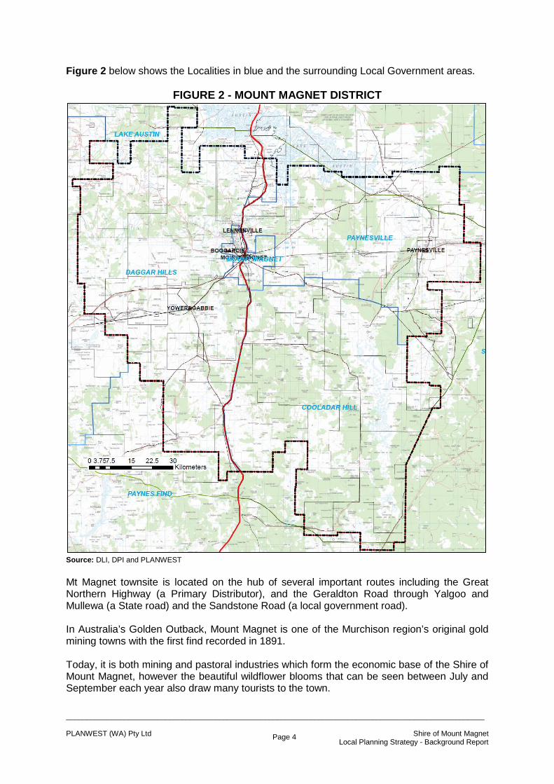
Figure 2 below shows the Localities in blue and the surrounding Local Government areas.
FIGURE 2 - MOUNT MAGNET DISTRICT
Source: DLI, DPI and PLANWEST Mt Magnet townsite is located on the hub of several important routes including the Great Northern Highway (a Primary Distributor), and the Geraldton Road through Yalgoo and Mullewa (a State road) and the Sandstone Road (a local government road). In Australia’s Golden Outback, Mount Magnet is one of the Murchison region’s original gold mining towns with the first find recorded in 1891. Today, it is both mining and pastoral industries which form the economic base of the Shire of Mount Magnet, however the beautiful wildflower blooms that can be seen between July and September each year also draw many tourists to the town.

_____________________________________________________________________________________________________ PLANWEST (WA) Pty Ltd Shire of Mount Magnet Local Planning Strategy - Background Report
Page 5
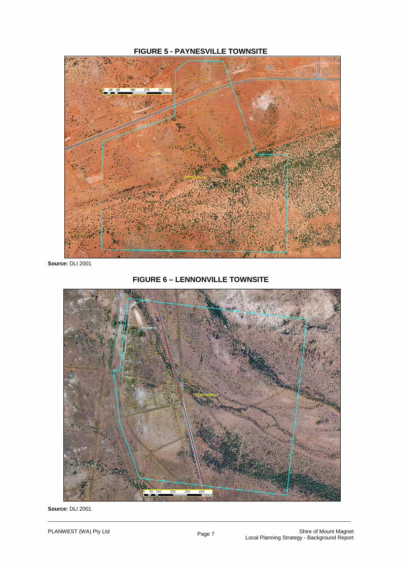
The Shire has four townsites, however Mount Magnet is the only one currently developed. These townsites include; Lennonville (10 km north of Mount Magnet); Paynesville (65 km east of Mount Magnet); Boogardie (6 km north west of Mount Magnet); and Yowergabbie (26 km south west of Mount Magnet). The aerial photograph shown overleaf in Figure 3 provides a view of Mount Magnet Townsite with its development concentrated along the Great Northern Highway.
FIGURE 3 - MOUNT MAGNET TOWNSITE Source: DLI 2001 Mount Magnet (301ha) is clearly the central administration, recreational, commercial, cultural and residential centre of the Shire. The townsite is home to the Shire Office, public library, museum, sportsground, cemetery and a tourist information centre on the main street. The Mount Magnet caravan park operated by the Shire provides a variety of on-site units and caravan bays. The following aerial photographs provide an indication of the extent of development at the Shire’s other townsites.

_____________________________________________________________________________________________________ PLANWEST (WA) Pty Ltd Shire of Mount Magnet Local Planning Strategy - Background Report
Page 6
FIGURE 4 - BOOGARDIE TOWNSITE Source: DLI 2001 Boogardie, shown on Figure 4 has no urban development and is only 89 hectares in total. The mining operations throughout the townsite have rendered the area unsuitable for any other development. None of the land is owned in fee simple. The main road shown in the southern part of the townsite (Palmers Well Road), has already been relocated to provide for mining operations. Indications are that the road may need to be relocated again to allow these operations to further expand. Figure 5 provides an aerial view of Paynesville (about 100 hectares). The Mt Magnet-Sandstone Road can be seen crossing the northern part of the townsite without regard to cadastral boundaries. The previous alignment can be seen about 400 metres south of the current alignment. Again there are no freehold lots in the townsite. Lennonville (149ha) is located less than 10 kilometres north of Mt Magnet townsite. The Great Northern Highway now dissects the town without regard to the lot layout. A previous highway alignment can be seen by the scar heading northwards from midway through the town. The railway used to abut the western edge of the town and provided a lifeline to the many inhabitants during its heyday. Some parts of the town have been recognised with information plaques and the town has been included in a heritage trail (discussed later). Figure 6 shows the lack of development in the town, but retains some remains of the previous road configuration. There are only 4 freehold lots in the town.
_____________________________________________________________________________________________________ PLANWEST (WA) Pty Ltd Shire of Mount Magnet Local Planning Strategy - Background Report
Page 7
FIGURE 5 - PAYNESVILLE TOWNSITE Source: DLI 2001
FIGURE 6 – LENNONVILLE TOWNSITE Source: DLI 2001
_____________________________________________________________________________________________________ PLANWEST (WA) Pty Ltd Shire of Mount Magnet Local Planning Strategy - Background Report
Page 8
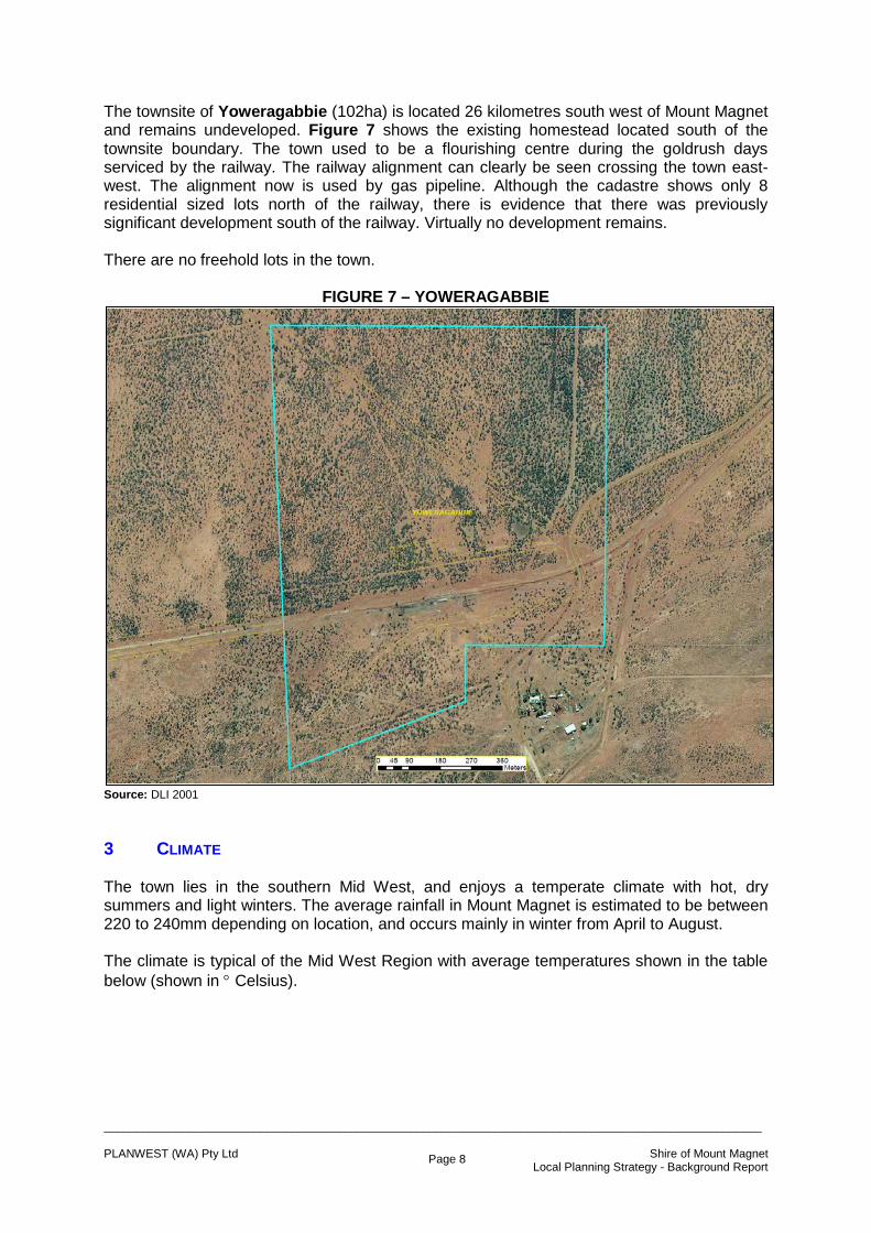
The townsite of Yoweragabbie (102ha) is located 26 kilometres south west of Mount Magnet and remains undeveloped. Figure 7 shows the existing homestead located south of the townsite boundary. The town used to be a flourishing centre during the goldrush days serviced by the railway. The railway alignment can clearly be seen crossing the town east-west. The alignment now is used by gas pipeline. Although the cadastre shows only 8 residential sized lots north of the railway, there is evidence that there was previously significant development south of the railway. Virtually no development remains. There are no freehold lots in the town.
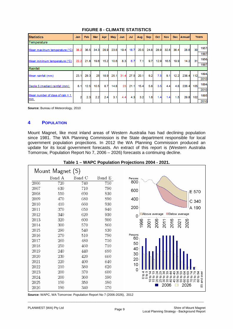
FIGURE 7 – YOWERAGABBIE Source: DLI 2001 3 CLIMATE The town lies in the southern Mid West, and enjoys a temperate climate with hot, dry summers and light winters. The average rainfall in Mount Magnet is estimated to be between 220 to 240mm depending on location, and occurs mainly in winter from April to August. The climate is typical of the Mid West Region with average temperatures shown in the table below (shown in ° Celsius).
_____________________________________________________________________________________________________ PLANWEST (WA) Pty Ltd Shire of Mount Magnet Local Planning Strategy - Background Report
Page 9
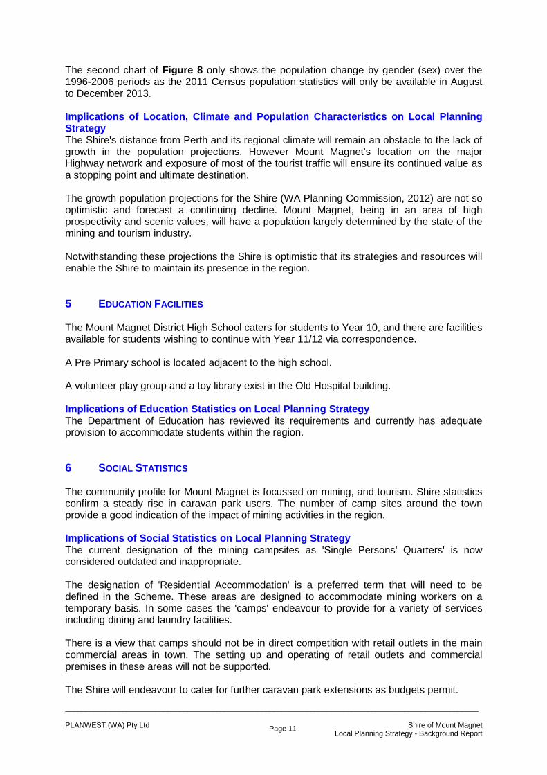
FIGURE 8 - CLIMATE STATISTICS Source: Bureau of Meteorology, 2010 4 POPULATION Mount Magnet, like most inland areas of Western Australia has had declining population since 1981. The WA Planning Commission is the State department responsible for local government population projections. In 2012 the WA Planning Commission produced an update for its local government forecasts. An extract of this report is (Western Australia Tomorrow, Population Report No 7, 2006 – 2026) forecasts a continuing decline.
Table 1 – WAPC Population Projections 2004 - 2021. Source: WAPC, WA Tomorrow: Population Report No 7 (2006-2026), 2012

_____________________________________________________________________________________________________ PLANWEST (WA) Pty Ltd Shire of Mount Magnet Local Planning Strategy - Background Report
Page 10
There has been some discussion within the Shire about population counts in the Census years. There is evidence that many residents did not receive Census forms although it is understood that many residents are not permanent. This concern is reflected in the following Figure 8 sourced from the Australian Bureau of Statistics (ABS). The second chart clearly demonstrates the apparent change in the predominance of males (in the workforce groupings).
FIGURE 8 - POPULATION STATISTICS
Source: ABS, 2006
SHIRE OF MOUNT MAGNET Age by Sex ABS Groupings
-200 -150 -100 -50 0 50 100
0-4
5-14
15-19
20-24
25-34
35-44
45-54
55-64
65-74
75-84
85 years and over
AG
E G
RO
UPS
POPULATION
2006 Female2006 Male2001 Male2001 Female1996 Male1996 Female
Males Females
_____________________________________________________________________________________________________ PLANWEST (WA) Pty Ltd Shire of Mount Magnet Local Planning Strategy - Background Report
Page 11
The second chart of Figure 8 only shows the population change by gender (sex) over the 1996-2006 periods as the 2011 Census population statistics will only be available in August to December 2013. Implications of Location, Climate and Population Characteristics on Local Planning Strategy The Shire's distance from Perth and its regional climate will remain an obstacle to the lack of growth in the population projections. However Mount Magnet's location on the major Highway network and exposure of most of the tourist traffic will ensure its continued value as a stopping point and ultimate destination. The growth population projections for the Shire (WA Planning Commission, 2012) are not so optimistic and forecast a continuing decline. Mount Magnet, being in an area of high prospectivity and scenic values, will have a population largely determined by the state of the mining and tourism industry. Notwithstanding these projections the Shire is optimistic that its strategies and resources will enable the Shire to maintain its presence in the region. 5 EDUCATION FACILITIES The Mount Magnet District High School caters for students to Year 10, and there are facilities available for students wishing to continue with Year 11/12 via correspondence. A Pre Primary school is located adjacent to the high school. A volunteer play group and a toy library exist in the Old Hospital building. Implications of Education Statistics on Local Planning Strategy The Department of Education has reviewed its requirements and currently has adequate provision to accommodate students within the region. 6 SOCIAL STATISTICS The community profile for Mount Magnet is focussed on mining, and tourism. Shire statistics confirm a steady rise in caravan park users. The number of camp sites around the town provide a good indication of the impact of mining activities in the region. Implications of Social Statistics on Local Planning Strategy The current designation of the mining campsites as 'Single Persons' Quarters' is now considered outdated and inappropriate. The designation of 'Residential Accommodation' is a preferred term that will need to be defined in the Scheme. These areas are designed to accommodate mining workers on a temporary basis. In some cases the 'camps' endeavour to provide for a variety of services including dining and laundry facilities. There is a view that camps should not be in direct competition with retail outlets in the main commercial areas in town. The setting up and operating of retail outlets and commercial premises in these areas will not be supported. The Shire will endeavour to cater for further caravan park extensions as budgets permit.

_____________________________________________________________________________________________________ PLANWEST (WA) Pty Ltd Shire of Mount Magnet Local Planning Strategy - Background Report
Page 12
7 ABORIGINAL SITES The Department of Indigenous Affairs in response to initial contact usually suggests that initial investigations should include a desktop study to determine whether there are any known sites in the district. Over 130 sites are known to exist in the Shire. Most of these sites have no restrictions, they have open access and all appear on the interim register. Figure 9 shows a distribution of these areas. It should be understood that this Figure shows some sites as large square areas. These areas are designed to not be precise about the exact location of these sites for fear of interference. Implications of Aboriginal Sites on Local Planning Strategy As the Strategy is not suggesting any specific development proposals it is suggested that there are no implications. However, applicants for development approvals in the vicinity of the areas identified as having Aboriginal sites should be reminded of the need to protect and report findings immediately they are discovered.
FIGURE 9 - AREAS OF ABOROIGINAL INTEREST SOURCE: DIA

_____________________________________________________________________________________________________ PLANWEST (WA) Pty Ltd Shire of Mount Magnet Local Planning Strategy - Background Report
Page 13
8 TOURISM The Council is active in its promotion and support for tourism projects. Currently there is a Mt Magnet Heritage Tour of the townsite that includes a visit to some of the original buildings in town. These buildings include the Shire Offices, bank manager's house, school master's residence, old primary school, post office and residence, railway station master's house, court house, three hotels, police station, Bank of WA and the old hospital complex. A 'Magnet Tourist Trail' provides a route through the attractions around town. The trail starts at the Tourist Information Centre (the original Ambulance shed), and includes visits to several grave sites and a cemetery, caves, amphitheatre, a lookout, a museum, old racecourse and various other natural features. The Council has plans to better recognise previous settlements - like Lennonville. The old road alignments may be better shown, the remains of houses (assisted by a collection of old photographs of the town) will assist in building an image of its previous glory. A collection of old artefacts collected from the vicinity could also The railway platform can still be recognised and could be partly reconstructed with local materials. Implications of Tourist Attractions on Local Planning Strategy Tourism is an industry that will only grow in the future. The Council proposes to ensure that these sites are appropriately protected and managed in order to maximise their interest value and tourism appeal. A periodic review and update of both the Municipal Inventory and Trails Plans should be considered subject to funding availability. 9 LAND AVAILABILITY There are about 42 lots currently zoned residential that remain vacant, 5 'Single Persons' quarters' sites, 4 commercial and 1 industrial lot. The 42 residential lots are spread throughout the residential areas and amount to about 12% of all residential lots. Implications of Land Availability on Local Planning Strategy It would appear from the vacancy figures that the town has an adequate supply of residential land for the near future - providing the region is not affected by a significant development (for example an influx of people related to a mining project). However, many of the lots identified as vacant are not necessarily available for sale. As a result, the Council may consider progressing with a new residential subdivision. The land on the corner of Priestley and Naughton Streets provides an ideal opportunity for additional residential land. The Council will pursue the issue of servicing new land in this location. There are only 4 commercial lots and 1 industrial lot that remain vacant. It is apparent that some of the existing commercial buildings could be better used if needed. Any extension of the commercial area should be restricted to the Highway frontage and contiguous to the existing commercial land.

_____________________________________________________________________________________________________ PLANWEST (WA) Pty Ltd Shire of Mount Magnet Local Planning Strategy - Background Report
Page 14
Available industrial land is virtually non-existent. There is an area west of the existing industrial area that is zoned in the existing scheme, and will be zoned in the new Scheme, however the land has not yet been subdivided. The Council will take the necessary action to progress with this proposal.
FIGURE 10 - VACANT LAND IN TOWNSITE Source: Background TPS 1, WA Planning Commission 2010 The Council is keen to ensure that there is a supply of all types of land and, following some research to establish demand, will further investigate creating a choice of lot sizes (and lifestyles). For example, there may be a demand for larger residential lots of 4,000m2 (1 acre), or 1 hectare (2.4 acres) - or even larger, where people may want that physical separation from neighbours. Obviously land ownership, prospective areas and servicing issues will need to be addressed.
_____________________________________________________________________________________________________ PLANWEST (WA) Pty Ltd Shire of Mount Magnet Local Planning Strategy - Background Report
Page 15
10 SHIRE FACILITIES AND AMENITIES The Shire and residents have created a wide and varied range of activities and clubs to ensure maximum participation, interaction and cohesion of the community. Recreation and Other Facilities include; Swimming Pool, Recreation Centre, Race Track, Golf Course, Public Oval, Foster Park Play Ground, Picnic Area at The Granites, Museum, Library, Court House, Cinema, BMX Bike Track, ANZAC Hall, Centrelink and Medical Centre. Other Groups, Clubs and Associations include; Aboriginal Art Gallery, Aboriginal Parent Program, Presbyterian and Catholic Church, Tourist Information Centre, motel units and hotels. Implications of Shire Facilities and Amenities The Shire is well served with facilities and amenities in the townsite of Mt Magnet. 11 TRANSPORT FACILITIES As mentioned earlier, Mt Magnet townsite is located on the hub of several important routes including the Great Northern Highway (a Primary Distributor), and the Geraldton Road through Yalgoo and Mullewa (a State road) and the Sandstone Road (a local government road). The Great Northern Highway is a strategic freight, tourist and inter-town route that carries a diverse range of vehicle types. This road carries some extremely large oversize loads bound for the Pilbara and Kimberley Regions, specifically the iron ore and diamond mining operations. It also provides direct access to some large mining operations. There is a significant mix of all vehicle types on this road, including higher than normal tourist traffic during the wildflower season. There is a high percentage of very large restricted access vehicle (RAV) combinations on this road transporting many different products such as various types of mineral ore, fuel, grain, fertilizer, explosives and livestock. Relatively high crash rates exist on the section Mt Magnet to Newman due to livestock straying onto the road. A few mining operations are close to the current alignment and are looking to realign the roadway away from the open cut operations. The Main Roads strategy (2025) will seek to maintain the existing Highway to ensure the level of service is not reduced and reconstruct the narrow floodways to a 10 m wide formation. The Main Roads strategy will also seek to provide suitable overtaking opportunities at regular intervals to minimise driver frustration and improve the overall safety by erecting boundary fencing to prevent stray livestock encroaching onto the road reserve. The Geraldton-Mt Magnet Road is the major connector between the centre of Geraldton that links Brand and North West Coastal Highways with the Great Northern Highway. It also links the Murchison, the Goldfields and various pastoral activities as well as providing access to the port of Geraldton. This road is heavily utilised in the cartage of ore, grain and fertiliser. This road also provides direct links between the towns of Mullewa, Yalgoo, Mt Magnet and the City of Geraldton.

_____________________________________________________________________________________________________ PLANWEST (WA) Pty Ltd Shire of Mount Magnet Local Planning Strategy - Background Report
Page 16
There is a lot of traffic conflict towards the western end of this road due to the large amount of standard vehicular traffic mixing with pedestrians and increasing numbers of very large RAV combinations that utilise this road. These RAV combinations, with their relatively low acceleration, cause traffic to bunch up which creates delays and driver frustration. There are also a number of railway level crossings that add to the delays faced by motorists on this road. With the sealing of the Mt Magnet to Leinster route there now exists a good quality, efficient link from the Murchison and Goldfields areas to Geraldton. This will see an increase in the traffic usage of this road with a high percentage of it being large RAV combinations. The MRWA strategy is to improve the safety for all road users by widening the seal and increasing the shoulder width as well as selected improvements in the road geometry. Look at bridge options for the railway level crossings, both for safety and efficiency. Increase freight efficiency by improving east-west access into the Port of Geraldton as well as improving the safety of the RAV combinations passing through the towns on this route. This is expected to occur when the Geraldton Southern Transport Corridor Stage 2 is complete. The Mount Magnet-Sandstone Road provides for the movement of heavy freight, tourists, commuter traffic and large oversize loads. It also provides access to a number of large mining operations and acts as a connector between the Goldfields and the Mid West Regions. Large volumes of freight are transported along this road with a high proportion heading to and from the port facility at Geraldton. This road also provides access to a number of pastoral operations. The traffic volumes on this road have increased since the seal was completed. It has attracted a lot of operators that previously would have travelled from the Goldfields to the north of the State using the Meekatharra to Wiluna section of Goldfields Highway. There is a need to provide adequate pavement and shoulder maintenance, inclusive of sign maintenance, to ensure this road remains in the condition it is in as a result of the recent completion of the upgrade and seal. Future mining development may see even more large RAV combinations on this road so additional overtaking opportunities may need to be considered. Transwa provides a bus service from Geraldton, Meekatharra and Perth with comfort stop at the Swagman Roadhouse in Mt Magnet. This service requires different connection depending on the destination and runs twice weekly. Implications of Transport Facilities on Local Planning Strategy Any new development, especially affecting the alignments outlined above, should minimise direct access to these roads by providing independent access and road systems. Maintaining an efficient structure of routes for cartage of minerals and mining infrastructure, through the Shire will assist in keeping the district in the activity network. As indicated above there is a need for some safety upgrades to improve the shared use for freight and local traffic. The Council will endeavour to clarify the alignment of these major roads where they do not follow existing road reserves in consultation with Main Roads WA.

_____________________________________________________________________________________________________ PLANWEST (WA) Pty Ltd Shire of Mount Magnet Local Planning Strategy - Background Report
Page 17
12 SERVICING ISSUES Water Supply There are a series of bores north west and south west of the Mt Magnet Townsite. These borefields provide adequate supplies for a potable water supply for Mt Magnet. Figure 18 shows the location of the public drinking water source protection areas (PDWSA) in the Shire. Where no piped water supply is available in the Shire, stations for example, alternative provision should be made through roof-top collection and tank storage.
FIGURE 18 - PUBLIC DRINKING WATER SUPPLY AREAS Source: WAWA, PLANWEST Wastewater There is no deep sewerage in Mt Magnet. All development operates on individual septic tank and leach drain systems.

_____________________________________________________________________________________________________ PLANWEST (WA) Pty Ltd Shire of Mount Magnet Local Planning Strategy - Background Report
Page 18
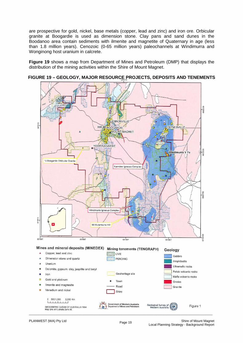
Rubbish Collection/Disposal Mobile garbage bins are supplied to each town resident and are collected every week. The Shire rubbish tip is located less than 2 kilometres east of the Mt Magnet townsite. Three is a second tip site located east of the Lennonville townsite; however this facility is not in use. Power Supply Power to all development within the Shire is supplied by Western Power. The power station is located 2.5 kilometres south of Mt Magnet townsite. Gas Supplies LPG Gas is supplied in cylinders by a local distributor. Fire Management and Ambulance Service Fire fighting facilities and St John's Ambulance facilities are provided for the town. The Shire operates on effective and active volunteer fire brigade service. Implications of Services within the Shire on Local Planning Strategy There are no implications on the Strategy for any of these facilities as they are considered appropriate for the town. 13 GEOLOGY Natural Resources All mineral exploration and mining in WA is subject to the provisions of the Mining Act 1978, which is administered by Department of Mines and Petroleum (DMP). Minerals, as defined by the Mining Act 1978, include all naturally occurring substances obtained from any land by mining; however construction materials such as limestone, rock, gravel, and sand are not considered to be minerals where they occur on private land. The Geological Survey of Western Australia (GSWA) aims to meet DMP's objective of 'achieving responsible development of industry and resources for the benefit of Western Australians'. This is achieved through the provision of quality geo-scientific data and information and advice to the mining and petroleum industries, government and public to encourage and support resource exploration and facilitate informed land use planning and State development. GSWA has a responsibility for investigating and reporting on all occurrences of minerals in WA including industrial minerals and basic raw materials. The DMP can make recommendations concerning the protection of strategic resources of specific minerals from sterilisation as a consequence of residential or industrial development or the construction of roads or other infrastructure. The responsibility for implementing such recommendations rests with local government, the Department of Planning and the Western Australian Planning Commission. Advice from the Geological Survey WA indicates that the Shire is underlain by rocks of at least 2,500 million years old that comprises granites, gneisses, gabbro, felsic volcanic, mafic volcanic, and minor ultramafic rocks of the Yigarn Craton. Two important igneous complexes, namely Windimurra and Narndee are located within the Shire. The Windimurra Igneous Complex is the largest of its kind in Western Australia and hosts vanadium and iron resources. The Narndee Igneous Complex contains platinum and palladium. Both complexes have potential for further discoveries of vanadium and iron, and lesser amounts of nickel, copper, platinum and palladium. Felsic and mafic volcanic rocks (greenstones) in the Shire,
_____________________________________________________________________________________________________ PLANWEST (WA) Pty Ltd Shire of Mount Magnet Local Planning Strategy - Background Report
Page 19
are prospective for gold, nickel, base metals (copper, lead and zinc) and iron ore. Orbicular granite at Boogardie is used as dimension stone. Clay pans and sand dunes in the Boodanoo area contain sediments with ilmenite and magnetite of Quaternary in age (less than 1.8 million years). Cenozoic (0-65 million years) paleochannels at Windimurra and Wonginong host uranium in calcrete. Figure 19 shows a map from Department of Mines and Petroleum (DMP) that displays the distribution of the mining activities within the Shire of Mount Magnet. FIGURE 19 – GEOLOGY, MAJOR RESOURCE PROJECTS, DEPOSITS AND TENEMENTS

_____________________________________________________________________________________________________ PLANWEST (WA) Pty Ltd Shire of Mount Magnet Local Planning Strategy - Background Report
Page 20
The data base reports 651 mines, prospects and mineral deposits in the Shire for a variety of minerals including gold, vanadium, platinum, palladium, uranium, iron, ilmenite, base metals, nickel, beryl, magnesite, tungsten, gypsum and dimension stone. Of these, Windimurra Vanadium and Hill 50 – Mt Magnet Gold are the major resource projects. The Shire remains an important centre for gold mining with significant potential for further discoveries. Mining of Construction Materials Advice from the DMP indicates that there are no registered sites located on Crown Land in its data base. The Council has no registered quarries on Freehold land. Mineral and Petroleum Tenements There are currently 357 granted mining tenements and 89 mining tenement applications wholly or partly within the Shire. Most of the granted tenements are for gold, nickel, lead, uranium, copper, zinc and potash. Geoheritage Geoheritage sites are defined by the Director of the Geological Survey of Western Australia as ‘Geological features considered to be unique and of outstanding value within Western Australia and to have significant scientific and educational values for the good of the community’. Two Geoheritage sites within the Shire are described as;
• No 15, Boogardie Orbicular Granite – orbicular granite. • No 96 – Mulermurra Hill – Archean agglomerate (volcanic rock consisting of large
fragments fused together). The site occurs within the Narndee Station. These sites can be viewed in more detail on the DMP’s GeoVIEW.WA website on; hhtp://www.dmp.gov.au/7113.aspx using under the heading of ‘Special Category Lands’. Mining related activity within Geoheritage sites is closely managed by the DMP. Implications of Geology within the Shire on Local Planning Strategy The wealth in mineral resources in the Shire is significant. The Shire can benefit socially and economically from the development of mineral resources and its support with therefore be forthcoming. The Council is aware of the powers of the Mines and Petroleum Act however it will require that conflicts between the Scheme and mining activities be resolved through cooperative negotiation. Ultimately the respective Ministers will need to agree to a resolution of any such issues where negotiations are unsuccessful. 14 ENVIRONMENT Prime Agricultural Land There is virtually no such land in the Shire. Agricultural Significance and Degradation The land has previously been used for sheep grazing and still remains an activity on the alluvial plains. The activity now has less significance particularly in regard to the Scheme review.
_____________________________________________________________________________________________________ PLANWEST (WA) Pty Ltd Shire of Mount Magnet Local Planning Strategy - Background Report
Page 21
Salinity Most of the land in the vicinity of the townsite is affected by salt. The town was probably located in its current location as it sits on a rocky extrusion rather than for the quality of its soils. Threatened Species and Communities There very few occurrences (2) of Declared Rare Flora and no recordings of Threatened Ecological Communities occur in the Shire. DEC Managed Estate The Department of Environment and Conservation does not manage any estate within the Shire. Contaminated sites The Shire has enquired about the records of contaminated sites with the Department of Environment and Conservation, however no locations have been made available. Implications of the Environment within the Shire on Local Planning Strategy Whilst the Council acknowledges that known data does not preclude the discovery of new floral communities, it will ensure that any new development will take the known sites into consideration in its determinations.