shf community risk assessment report2 - radar.org.za home farm community risk... · philippi, cape...
TRANSCRIPT

1
University of Cape Town
Department of Environmental & Geographical Science
Community Risk Assessment Report
Sweet Home Farm
July 2009
A consolidation of the reports compiled by the Disaster Risk Science Honours students from the University of Cape Town after undertaking a Community Risk Assessment training exercise in Sweet Home Farm, Philippi, Cape Town in March 2009.

2
Acknowledgements
The Disaster Mitigation for Sustainable livelihoods Programme would like to thank all the members of the Sweet Home Farm community who so willingly gave their time to participate in this exercise.
We are also grateful to all those who attended and gave valuable input at the stake holder discussion session. Among them:
Faizel Andrews from the City’s Environmental Health Department
The Fezeka Fire Team under Paul Myburgh
Luzuko Gangatele from the City’s Water and Sanitation Department
Ngcwele Dyani from the City’s Water and Sanitation Department
Joy Klimbashe, Siyamboleka ‘Goodman’ James and colleagues from The Warehouse
Charlotte Adams and Joyce Cwayi from Uvimba Health Promotions
Lennox Mashazi from City of Cape Town Disaster Management
Anzil Sampson from the Department of Health
Apologies for any names that may have been omitted here
Thank you also to ARG design for the provision of many background documents that informed this study.

3
Introduction
The South African Disaster Management Act and National Disaster Management Framework calls for increased efforts to reduce risks developmentally. Disaster risk refers to the chance of hardship or loss resulting from the interaction between natural or other hazards and vulnerable households exposed to them. Disaster risk reduction in informal settlements refers to all policies, actions and initiatives that minimise vulnerabilities and disaster risks in informal settlements, including prevention, mitigation and preparedness.
Disaster risk reduction can include both structural and non-structural interventions. The latter involves urban planning, education, health and other social vulnerability reduction measures. Social development actions can also reduce risks. Closer cooperation and confidence between settlement residents and local authority representatives can improve municipal service delivery as well as strengthen local responsibility for recurrent risks. Many risks in informal settlements are strongly rooted in social and economic vulnerability, along with unstable sources of livelihood.
The Sweet Home Farm Community Risk Assessment formed the fieldwork component of the Honours course. Seventeen students undertook training in Community Risk Assessment accompanied by members of the Sweet Home farm community on the 25th and 26th March 2009.
What is a Community Risk Assessment (CRA)?
Participatory risk assessment is a methodology that has been developed to engage communities developmentally, using highly participatory approaches and a bottom-up approach. It provides insights into how risks are generated and can be reduced. A Community Risk Assessment can be adapted and applied in numerous contexts, for a wide range of risks. It is underpinned by a commitment to participatory engagement with at-risk communities and relevant stakeholders. Informal settlements are diverse; therefore risk reduction efforts will vary from one settlement to another.
In the Western Cape context it is generally poor marginalised households in informal settlements and low-cost housing that are most vulnerable to fires, severe weather events and seasonal flooding, especially when they are located in risk-prone and ecologically-fragile areas. Government departments have been hard-pressed to keep pace with rapidly growing and often unplanned demands for service provision – including the maintenance and expansion of essential public infrastructure.
Community-based disaster risk management (CBDRM) is an approach that aims to reduce local disaster risks through the application of participatory assessment and planning methods, aiming to strengthen people’s capacities to manage specific disaster risks. The CBDRM approach allows a wide group of stakeholders, including residents, civil society organisations and local government role players to jointly understand the disaster risk profile in a particular settlement.

4
Undertaking a CRA in Sweet Home Farm and Student report consolidation
Five groups of Honours students conducted fieldwork exercises in Sweet Home Farm over a 2-day period, from 25th to 26 March 2009. Each group was accompanied by a University of Cape Town facilitator and at least one local resident. Many other residents contributed to the exercises during the transect walk, allowing for a broader consensus of opinion on local risk issues. Each student was tasked to interview at least two members of the community during the transect walk in order to pose more in depth questions regarding local coping strategies in terms of the particular risk prioritised. Each group later wrote up their assessment results in a comprehensive report which was submitted to the Disaster Risk Science Department at the University of Cape Town. This report is a consolidation the observations and analyses of those five reports, including the suggestions and recommendations made by the students.
Sweet Home Farm is currently divided into Sections A to H. The students were divided into five working groups and undertook to assess the risks in Sections, A, B, C, D + F, G+H. The boundaries of these sections do not conform to road boundaries for the most part, having been created prior to the provision of a formal road infrastructure. During the transect walks the student groups were tasked to use a GPS to plot the boundaries of the sections they were surveying as they are not formally marked on the landscape. The idea of this exercise was to plot these boundary lines on an aerial photograph in order to provide the leadership structure of Sweet Home farm with a map clearly denoting these invisible border lines for future decision-making processes. The GPS points were also used to map the spatial distribution of resources as well as perceived risks.
Limitations of the study
It is important to acknowledge several limitations in this Assessment. Firstly, key stakeholders may have been excluded during the gathering of data. As the study was conducted over two week days many of the economically active residents would have been at work and their opinions are therefore not represented. Second, a lack of clarity and consistency from participants may have affected the results. In addition the local participants changed from session to session and this may have led to some confusion about the purpose and context of the exercises. Finally, as most students were not Xhosa-speakers themselves, some nuanced yet valuable information may have been lost in translation.

5
A brief introduction to Sweet Home Farm
Sweet Home Farm is an informal settlement in Philippi East. Approximately 16,5 ha in size it is situated at the southern end of Duinefontein Road, bounded by the Nyanga railway line on the eastern side, Lansdowne Road on the northern side, and Vanguard Drive on the south-western side. It lies adjacent to the suburb of Samora Machel on with Guguletu to the north, Browns farm to the East, Weltevreden Valley to the South East and the agricultural part of Philippi to the West.
Originally a rubbish dump located in what was originally the farmland area of Philippi, today Sweet Home Farm is home to 3 800 households and approximately 17 000 people. The community is largely comprised of Xhosa-speaking Africans, but there are also several migrants from other African countries, and a small coloured community who are descendents of the original farm labourers who settled on the land over 25 years ago when the farm was known by the name of ‘Die Vlei’. They reportedly also speak Xhosa and are well integrated within the community.
The majority of residents is aged between16-34, thus the settlement exhibits a fairly young population, with a larger number of female than male-headed households, although there are reportedly less females than males in the settlement. The majority of households live in extreme poverty, practicing subsistence survival strategies. An ARG report (2006) recorded an unemployment level of 53%, with more women unemployed than men. Shockingly, 52% of those who were unemployed had never worked in paid jobs before. At least 40% of the households are receiving some form of state grant.
The following background information was compiled before the Community Risk Assessment was undertaken. Many of the issues mentioned were further investigated during the survey.
Figure 1. Aerial view of Sweet Home Farm 2009 (Source Google Earth)

6
Development history
Sweet Home Farm was well known for many years as a dumping ground for builders’ rubble, and the first informal residents began earning a living by recycling dumped used bricks and selling them by the roadside. This activity continues today and is clearly in evidence on Duinefontein Road.
In 1992 a gradual influx of people began, and by January of the following year 52 dwellings were spread out over a large area. By May 1996 this had grown to 373 dwellings, and this number more than doubled over the next two years to 886. A survey undertaken by the City of Cape Town in July 2003 recorded 2 217 households and estimated that there were 7 045 people living in the settlement. Today there are reportedly over 17 000 people living in the settlement and the number of dwellings has increased commensurately to nearly 4000.
Initially there were no municipal services because much of the settlement was located on private land. However, the settlement continued to grow and as the density increased conditions worsened, especially during the winter months when flooding occurred. Eventually the City was forced to take action and they negotiated to buy the land. They were able to purchase all but a large middle section and a thin piece of South African Rail Commuters Corporation (SARCC) land. Thus, today Sweet Home Farm is situated on a number of different erven, some private, some belonging to SARCC, but most on City land. Negotiations with the private land owner failed completely and he refused the City Council permission to provide basic services on his land, maintaining that he wanted to develop the area, which reportedly has industrial zoning. However, SARCC willingly agreed to allow Council to provide services both on, and over, their land. After a report covering three informal settlements commissioned by the City, one of which was Sweet Home Farm, the City undertook a rudimentary services upgrade for the provision of “temporary and rudimentary services in order to maintain an acceptable degree of health and hygiene” (City of Cape Town project brief).
The area today is divided into eight sections with a spatially differentiated provision of services, so that while the City land is well provided with infrastructure, this is starkly contrasted with the private land, which has no electricity or essential services. Electricity has been provided to residents living on the City-owned land together with basic street lighting.
The road layout was undertaken by a consulting engineering firm, and was designed to enable a future township layout, taking into consideration the large private portion that cannot be serviced. The following services were then installed in a project that ran from October 2005 to December 2006: gravel tracks; open channel storm water with some underground connections onto existing infrastructure; a retention pond; a sewerage reticulation with shared toilet facilities; a water reticulation with shared standpipes.
Table1. Sanitation provision in Sweet Home Farm (Source: City of Cape Town, Water & Sanitation Dept.)
NAME
Chemical Container Full Flush Pit Pour Flush Total Standpipes
SWEET HOME 117 136 102 40 212 607 115
7
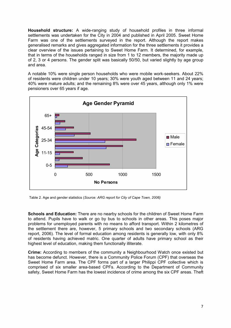
Household structure: A wide-ranging study of household profiles in three informal settlements was undertaken for the City in 2004 and published in April 2005. Sweet Home Farm was one of the settlements surveyed in the report. Although the report makes generalised remarks and gives aggregated information for the three settlements it provides a clear overview of the issues pertaining to Sweet Home Farm. It determined, for example, that in terms of the households ranged in size from 1 to 12 members, the majority made up of 2, 3 or 4 persons. The gender split was basically 50/50, but varied slightly by age group and area.
A notable 10% were single person households who were mobile work-seekers. About 22% of residents were children under 10 years; 30% were youth aged between 11 and 24 years; 40% were mature adults; and the remaining 8% were over 45 years, although only 1% were pensioners over 65 years if age.
Age Gender Pyramid
0 500 1000 1500
0-5
11-15
25-34
45-54
65+
Age Categories
No Persons
Male
Female
Table 2. Age and gender statistics (Source: ARG report for City of Cape Town, 2006)
Schools and Education: There are no nearby schools for the children of Sweet Home Farm to attend. Pupils have to walk or go by bus to schools in other areas. This poses major problems for unemployed parents with no means to afford transport. Within 2 kilometres of the settlement there are, however, 5 primary schools and two secondary schools (ARG report, 2006). The level of formal education among residents is generally low, with only 8% of residents having achieved matric. One quarter of adults have primary school as their highest level of education, making them functionally illiterate.
Crime: According to members of the community a Neighbourhood Watch once existed but has become defunct. However, there is a Community Police Forum (CPF) that overseas the Sweet Home Farm area. The CPF forms part of a larger Philippi CPF collective which is comprised of six smaller area-based CPFs. According to the Department of Community safety, Sweet Home Farm has the lowest incidence of crime among the six CPF areas. Theft

8
is the most prevalent crime, often resulting in grievous bodily harm. There is, however, a fairly low incidence of more serious crimes such as murder1.
Health issues: According to the Environmental Health officer for the area there are several issues of concern with regard to environmental health. There have been unsubstantiated reports of the burying of dead chickens by the neighbouring chicken farm, which could have serious health implications for adjacent shack dwellers. There are problems with the constant vandalisation of toilets by disgruntled members of the community attempting to force their replacement with full-flush toilet systems. The dumping of rubble and rubbish close to the settlement encourages vermin, posing serious health threats to the community. ‘Green’ foul smelling water frequently builds up in the stormwater channels and is currently a concern of the local health department
ARG, which conducted surveys in the area a few years ago, established that there are still too few toilets to service the community (2006). The long walk to the toilets for women, children and the aged has prompted the adoption of alternative sanitation strategies, leading to problems of open sewage and substandard hygiene conditions in parts of the settlement.
A report by ARG (2006) found that 22% of the population suffered from either chronic illnesses or disabilities. Among the chronic illnesses encountered during the survey were the following statistics:
� TB 23,8%
� Asthma (9,5%)
� Hypertension (8,6%)
� Stomach ailments (8,6%)
� HIV/AIDS (3,8%) – while treatment was recorded for only 29 households this is likely to be underreported due to the social stigma associated with the disease.
The ARG report identified a chronic need for a clinic on site. The nearest clinic situated in Lansdowne Road only services children and TB patients, while the Philippi clinic is situated at quite a distance from the settlement and services a large area, including Brown’s Farm. It does not have an outreach programme, being staffed only at the Clinic itself.
Disaster risk profile: Sweet Home Farm is susceptible to may risks particularly during the winter months. The Disaster Risk Management Department supplied the table below for 2007 which illustrates the area susceptible to flooding. There is a substantial depression in the centre which becomes a pond in winter. Much of this falls on the privately-owned land and is not included in the statistics mentioned for the City land in the table below. A community leader reported that although the last floods experienced there were not as bad as previously, in August 2001 the settlement had experienced a devastating flood.
Shack fires occur fairly regularly. The homes typically are made from wood, cardboard, tin and other flimsy and combustible materials. The latest fire, in late January 2009, raised nine dwellings in the settlement.
1 Unfortunately, although invited, the CPF members and the SAPS section commander did not attend the stake
holder discussion session that followed the CRA process conducted in Sweet Home Farm and could not comment on crime prevalence in the settlement.

9
City of Cape Town - High Risk Flood Prone Informal Settlements - 2007
Settlement
Land Ownership
Sub- Council
Ward No.
Est. No.
dwellings
(2006)
Within Stormwa
ter Ponds
Designated Flood plains
Within Wetlands
Areas
Estimated
Annual Floodin
g Probability
Sweet Home
City 11(18) 43(80)
2,217 195 50%
Table 3. Flood information on City-owned portion of SHF in 2007 (Source Disaster Risk Management Dept.)
Surprisingly, despite the well documented risk of fire, flooding and crime in Cape Town’s informal settlements, the residents who participated in the CRA clearly identified other priority hazards as more concerning issues. Although fire and flood are well-known problems they tend to happen at different times of the year.
Because there are many factors that increase peoples’ risk, it is also important to recognise that risk can be reduced according to people’s’ capacities. The report therefore explores the capacities that residents already have to reduce their risks.
Figure 2. Fire damage in Sweet Home Farm, 2009.
Community-based organisations
The Warehouse, a faith-based organisation guided by Joy Klimbashe, has involved members of the community, in several projects, namely, a Senior Citizens' Club, an HIV/Aids Support Group, a Crèche and a Teenage Group. Whilst there are informal church gatherings in the area, there is nothing by way of a formal Church. However, land has been allocated by community leaders to facilitate the setting up of a church in Sweet Home Farm. A small Moslem community have constructed an informal Mosque structure on the Duinefontein Road boundary.

10
Community Risk Assessment: Unpacking the risks in Sweet Home Farm
The Community Risk Assessment was based on the outline and activities described in Weathering the Storm: Participatory Risk Assessment for Informal Settlements (Holloway & Roomaney, 2008). Community members assigned to each research team helped to assemble resident participants for the exercises. The following six exercises were applied in collaboration with local community members:
1. Hazard identification and Ranking
2. Problem Tree
3. Seasonal Calendar
4. Hazard Map
5. Transect Walk
6. Objectives Tree
Several major risks were identified during the Community Risk Assessment. These have been discussed individually in the section that follows. The report concludes with some recommendations the students have made in response to the risks identified.
Flooding
Located in a wetland area, flooding is a seasonal hazard for the residents of Sweet Home Farm. Flooding is commonly experienced between May and August, i.e. during the winter rainfall season. Climate change predictions suggest that although rainfall is set to decrease generally in the Western Cape region, the occurrence of severe weather events accompanied by intensified periods of heavy rainfall will become more frequent.
Although the residents of Sweet Home Farm have formed some coping mechanisms of their own at household level, they rely heavily on the City’s Disaster Management Department, placing a strain on the City’s already stretched resources. Residents try to lay down rubble before flooring to minimise the amount of damp or water that can seep into flooring from rain.
The storm water channels that flank the road infrastructure can be effective in containing flooding during high rainfall periods but their effective is being undermined for several reasons. Limited connectivity to underground sewer systems outside the settlement means that in low-lying areas where storm water tends to pool, the standing water becomes stagnant, presenting a health risk. The open storm water channels are very wide, causing residents to construct their own informal bridges in order to cross over them, causing blockages. A retention pond has been constructed to collect excessive rainwater after heavy downpours.
Elevation varies throughout the settlement but, according to Disaster Risk Management and local residents, there is a low-lying area in the centre of the settlement which transforms into a pond every winter. This area falls mainly on the privately-owned portion of the land. During the winter months flooding is therefore an expected risk and the poor structural integrity of the dwellings is a major concern. Having a decent shelter is the first line of defence, yet many dwellings have been built directly on the ground, with no foundation or protective flooring. This makes residents particularly susceptible to rising floods and also promotes damp and mould within the dwellings. Many homes have been built level with the roads so that water run-off flows easily into dwellings.

11
Disaster Management are called upon to provide aid to flooded residents every winter. This assistance for the most part takes the form of hot food and blankets. The presence of floodwater in residents’ homes makes it difficult for them either to light fires, or to use electrical appliances, making cooking impossible. Though it is possible for residents to relocate to nearby community halls, and some reported that they have done so on occasion, generally they prefer to remain in their homes for fear of break-ins during their absence. Household coping strategies involve placing crates across the floor to allow residents to walk around in their homes when the water level rises, using cardboard to soak up the water that seeps through the floors, and placing belongings in elevated areas while furniture, particularly beds, are raised on paint tins or other available materials to protect them from the water. Outdoor carpeting is often used externally to absorb water that could potentially enter homes.
Though flooding is perhaps the most constant risk, female respondents frequently claimed that the coping mechanisms they had adopted were sufficient to deal with it, though damage to property and the health of their children were concerning. Men, on the other hand, often considered floods their primary concern. This suggests that certain coping mechanisms may be more appropriate for one gender than another.
During the CRA residents identified areas where drainage systems have not been provided because the land is privately-owned and beyond the jurisdiction of the City. Vegetation, which could improve infiltration, is lacking due to the high housing density. After heavy rainfall informal roads and pathways become muddy and often flooded. Households use their own coping strategies to prevent water entering dwellings at such times, using rocks, gravel or sandbags to hold back flood water and to secure the entrances to their homes. These strategies tend to redirect flood water to other less-prepared shacks.
Fire
Fire is a major risk for the people living in Sweet Home Farm, partly because the materials predominantly used to build dwellings also provide excellent fuel for fire – e.g. wood and cardboard. The risk of fire increases as the population increases and the settlement becomes more crowded. The spacing between dwellings shrinks as space becomes limited so that it takes a matter of seconds for a fire to move from one dwelling to another, giving people little reaction time.
Figure 3 Minimal spacing between dwellings aids the rapid spread of fire

12
On the privately-owned land, which is not provided with formal electricity, residents still resort to illegal electricity connections, increasing their fire risk.
Figure 4 Illegal electricity connections on un-serviced private land
Throughout the settlement piles of wood and other debris can be found in spaces between dwellings and accumulated solid waste is also potential fuel in the event of a fire. Shebeens in the area further increase risk as drunken patrons may return home and make use of heating, lighting and cooking appliances, often falling asleep and leaving them unattended, which can lead to fires.
Fire risk is increased by a variety of factors at different times of the year. Fire tends to spread faster under hot, dry and windy conditions occurring during the summer months. During the festive season there is much celebration and increased negligence and fire data from the City reflects the prevalence of fires during this holiday period. During the winter months people tend to make more use of open fires to keep warm, particularly where there is no electricity provision. Open fires, open-flame stoves and candles are used more frequently due to reduced daylight hours and cold, wet weather, despite the provision of electricity. However, since electricity has been supplied by the City to the City-owned parts of the settlement there have reportedly been fewer fire events.
According to the Venn diagram exercise undertaken in the filed during the CRA, the Fire Department is seen as an important role player in the community. However, their efforts are hampered for several reasons. The settlement can only be accessed from two entrance points, neither of which gives direct access to a fire engine approaching from the local fire department, located around the corner in Guguletu. The deep storm water drains make it difficult for the fire engines to access some parts of the settlement, causing fire engines to have to remain in the road with fire-fighters hauling fire hoses into the settlement. Many households in the undeveloped areas do not have road access at all.
During interviews and focused group discussions it became evident that local avoidance measures and coping strategies have been developed to deal with fires. To avoid risk, residents understand the need to build their dwellings with an adequate space between them to prevent the rapid spread of fire. However, the crowded situations in the settlement often do not allow for this type of mitigation. In the event of a fire, residents explained that some dwellings are deliberately destroyed in order to halt the path of the fire. Others
13
described how residents create a human chain, passing buckets of water to extinguish the flames2.
In managing risk, local organisations play a crucial role in providing assistance to those who loose their possessions in a fire. Organisations such as The Warehouse sometimes provide assistance, although Disaster management is the primary source of assistance after a disaster providing food and blankets.
Environmental Health
In the past five years government-owned land within Sweet Home Farm has been provided with basic services – flush and non-flush toilets, water taps (stand pipes), storm water drains, roads and electricity except on the privately–owned land where this is not permitted by the landowner. Although these developments have improved the lives of many living in the settlement, much of this infrastructure has been outsourced to private contractors and has not been properly monitored or adequately maintained.
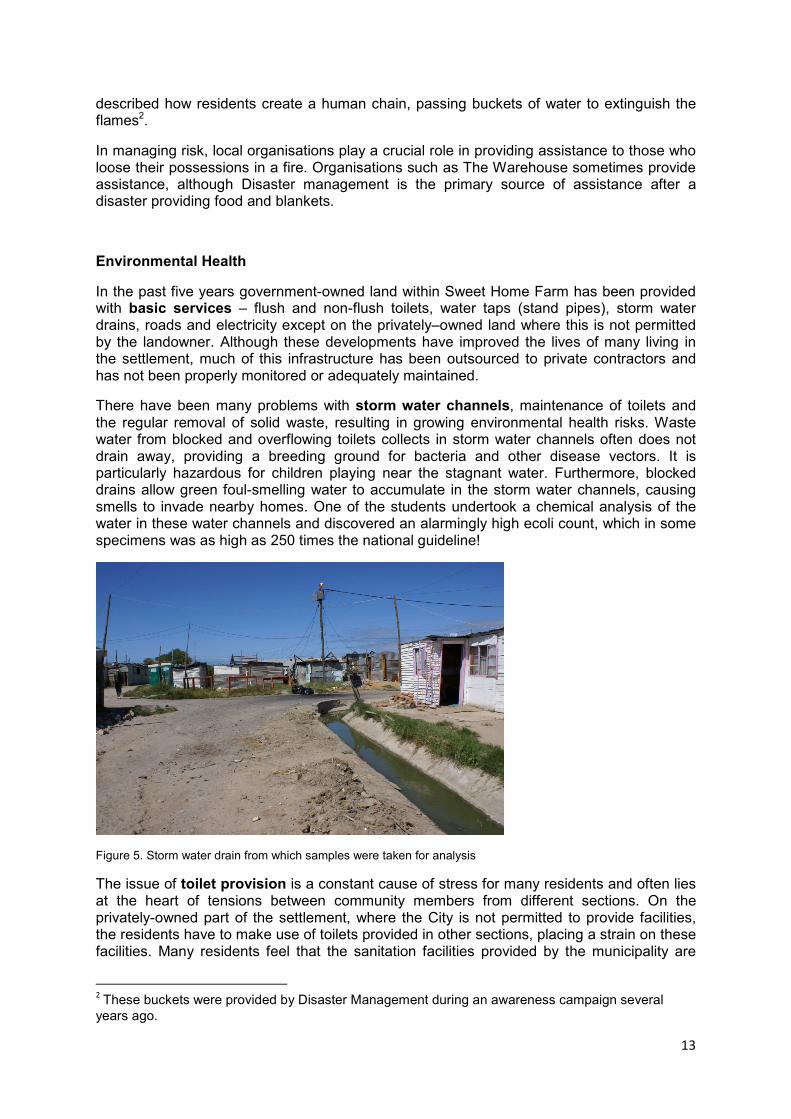
There have been many problems with storm water channels, maintenance of toilets and the regular removal of solid waste, resulting in growing environmental health risks. Waste water from blocked and overflowing toilets collects in storm water channels often does not drain away, providing a breeding ground for bacteria and other disease vectors. It is particularly hazardous for children playing near the stagnant water. Furthermore, blocked drains allow green foul-smelling water to accumulate in the storm water channels, causing smells to invade nearby homes. One of the students undertook a chemical analysis of the water in these water channels and discovered an alarmingly high ecoli count, which in some specimens was as high as 250 times the national guideline!
Figure 5. Storm water drain from which samples were taken for analysis
The issue of toilet provision is a constant cause of stress for many residents and often lies at the heart of tensions between community members from different sections. On the privately-owned part of the settlement, where the City is not permitted to provide facilities, the residents have to make use of toilets provided in other sections, placing a strain on these facilities. Many residents feel that the sanitation facilities provided by the municipality are
2 These buckets were provided by Disaster Management during an awareness campaign several
years ago.
14
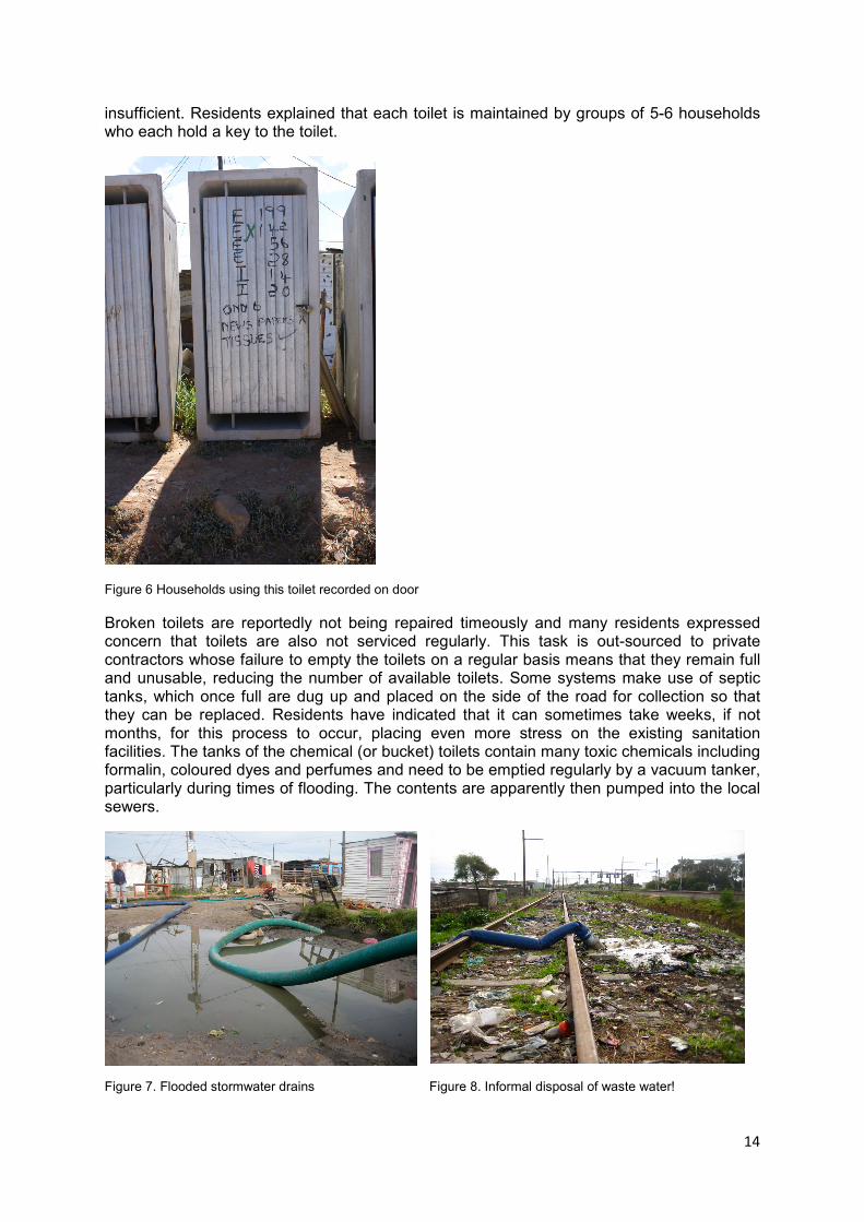
insufficient. Residents explained that each toilet is maintained by groups of 5-6 households who each hold a key to the toilet.
Figure 6 Households using this toilet recorded on door
Broken toilets are reportedly not being repaired timeously and many residents expressed concern that toilets are also not serviced regularly. This task is out-sourced to private contractors whose failure to empty the toilets on a regular basis means that they remain full and unusable, reducing the number of available toilets. Some systems make use of septic tanks, which once full are dug up and placed on the side of the road for collection so that they can be replaced. Residents have indicated that it can sometimes take weeks, if not months, for this process to occur, placing even more stress on the existing sanitation facilities. The tanks of the chemical (or bucket) toilets contain many toxic chemicals including formalin, coloured dyes and perfumes and need to be emptied regularly by a vacuum tanker, particularly during times of flooding. The contents are apparently then pumped into the local sewers.
Figure 7. Flooded stormwater drains Figure 8. Informal disposal of waste water!

15
However, during the winter months during high rainfall, the sewers often flood causing human waste to spill onto the streets, further exposing residents to environmental health hazards.
Some toilets are monopolised by individuals, and some units are even dragged away into front yards where they are kept behind fences, making use of the toilet exclusive to the household. Vandalism of toilets by community members is a constant problem, with the cutting and replacing of locks with ones own being a common practice. Intimidation is also used by individuals to monopolise toilets for personal use. In such circumstances residents are often left with no other options but to relieve themselves on the periphery of Sweet Home Farm in the grassy patches. Such practices pose further risk to young children, who, with limited options for recreational areas, end up playing in the close vicinity of toilet areas and in the grassy areas.
Many residents explained that the use of a bucket for sanitation within the home is common practice. Unable to access one of the more formalised toilet facilities in order to empty these buckets, and also as a result of embarrassment, the contents are often disposed of at night, either on grassy patches, on open-air waste dumps or, in some cases, onto a neighbour’s property. This type of behaviour compromises the health of all residents.
Many toilets are located adjacent to the street and a drainage canal which is already severely plugged with debris and garbage. Residents complained that during floods water reaches the doors of these toilets, making it unsanitary for those who use them. In one particular site in Section G a resident pointed out non-flush toilets filled with waste. Unable to use them, people had resorted to using the bushes nearby, or using the edge of the adjacent garbage heap to dispose of excrement. Such conditions clearly pose a threat to the community and households living in close proximity to the toilets. This area experiences flooding after heavy rain causing the toilets to overflow, so that as the ground becomes saturated from the rain, the waste concentrates in pools nearby.
Figure 9. Toilets adjacent to storm water canals in Sweet Home Farm
All residents within Sweet Home Farm make use of communal taps as their only water source. The communal water source comprises one tap at each site. Car tyres are often placed around the base of the tap in an attempt to limit the spread of spilt water and to help stabilise the base of the stand pipe. There are very few taps located on the privately-owned land yet the residents of this area did not highlight access to water as a specific problem.

16
The limited access to water within these sections may well impact on sanitary hygiene practices, particularly with regard to cleanliness and food preparation3.
Households are responsible for managing their own refuse. The City provides skips at certain collection points, often next to toilets and standpipes which already have access roads to allow for maintenance. Refuse bags are provided to residents and must be deposited in the skips provided which are supposed to be emptied regularly by out-sourced contractors. However many collection sites are serviced irregularly, resulting in a build-up of solid waste. The single largest problem appears to be the lack of sufficient skips, with many areas in the privately-owned sections of land not provided with skips at all, causing residents to leave garbage bags on street corners. Dogs, goats and rats tear open the bags spreading refuse throughout the settlement, which accumulates in drains and storm water channels that soon become blocked and dysfunctional, attracting other types of vermin and disease vectors and posing severe health risks to residents.
On the privately-owned land, there are no formal roads and no formal refuse collection points. Residents are expected to take their waste to the designated dumping sites located on the City-owned land, which invariably does not happen. Many residents highlighted this as a problem as any open space usually becomes a dumping site. Students observed gaps between houses that were filled with waste that had accumulated over time. Open refuse heaps ultimately contribute to the blockage of drainage canals, exacerbated during flooding conditions. Rats breed in these types of conditions, with abundant supply of food sources, and pose a constant health threat to all residents, reportedly also entering houses at night and biting sleeping residents.
Figure 10. Collection of garbage next to new stormwater detention pond
Historically the settlement was once a dumping ground for builder’s rubble and this practice continues today, encouraging vermin and other disease vectors. Unattended children play in areas of open sewage, rubbish dumps and around blocked drains making them more vulnerable than other community members to associated illnesses and diseases. One child was witnessed eating food selected from a dumping site, while another was seen playing
3 A small local health initiative, Uvimba Health Promotions has been teaching local residents to make use of the
‘squeegy bottle’ system. This is a simple hygiene mitigation strategy that requires a householder to keep a old ‘squeegy’ bottle filled with water tied next to the entrance to a dwelling with a bar of soap hanging next to it tied in an old stocking. Householders returning home squeeze water out of the bottle rub their hands with soap and then rinse them, especially before preparing food.

17
around standing water in the drainage channels. Residents commented that children eat food from the dump sites because they are hungry or due to childish cravings.
The seasonal calendar exercise revealed that the month of December is a time of increased solid waste accumulation. This is a time of increased social gathering over the festive season, with many celebrations. The general increase in the amount of food consumed results in a general increase in waste. People receive their bonuses at this time of the year and their increased buying power generates more waste. Flies and rats are reportedly more of a scourge at this time.
A chicken farm is located on the outskirts of the settlement. There have been unconfirmed reports of the burying of dead chickens by the neighbouring farm, which may have serious health implications for adjacent shack dwellers. An abundance of dogs, many in poor condition and covered in parasites, was a cause for concern. This can be perceived as a health risk, particularly when considering the high number of children that were observed wandering around the area unmonitored and also seen playing with these animals. Many residents reportedly considered the dogs as pests that rummage through garbage.
Rashes and other bacterial hazards pose a greater risk in areas where stormwater drains are blocked and stagnant water accumulates. Poor drainage conditions pose a risk throughout the year. During the winter months flood conditions spread contaminated water and it is known to enter people’s homes. Although the poor drainage conditions during the winter months cause greater risk to flooding, the excess water dilutes the bacterial accumulation, decreasing the hazard. In the drier summer months, however, the bacteria in the water become more concentrated and more potent.
The closest clinic to the settlement is two kilometres away on Lansdowne Road, greatly contributing to the vulnerability of the sick that have to find transport there. This caters for children and TB patients only. The Philippi clinic is further away but offers more comprehensive health services. Pharmacies are also located far away and many households struggle to afford medication which, although provided initially for free at local clinics, may require ongoing medication which the clinics cannot provide. The incidence of chronic illness within the settlement is said to be as high as 22%. There is no mobile clinic that services the needs of those who are too ill to reach the nearest clinic. A local organisation, Uvimba Health Promotions, run by two local ladies, has been promoting household and personal hygiene strategies to reduce health risks. Another method of coping discussed by community members is visiting a ‘witch doctor’, some of whom live in the settlement.
Residents have found remedies to deal with some health problems by themselves. For example, for diarrhoea, residents make use of oral rehydration solution to replace lost body salts. When children get rashes, which many residents associate with the problems of solid waste, they make use of calamine lotion to sooth the children’s’ rashes. For more serious ailments they make the journey to the health centres. However, residents reported that sometimes the queues are so long that they return home without receiving medical attention. In emergencies an ambulance is called.
Crime risk
Three of the student groups identified crime as the priority risk in the sections of the settlement in which they conducted their CRA. According to a 2005 City of Cape Town study of three selected informal settlement, one of which was Sweet Home farm City of Cape Town, 2005), 90% of respondents felt unsafe in their homes, while one third of households had been subject to crime in the previous year. Crime was identified as a risk that had economic, social and institutional causes. Despite having one of the lowest reported

18
incidences of crime in the Philippi region, crime is nevertheless considered a major problem by members of the Sweet Home community.
Robbery was cited as the most common type of crime, with shop-owners are particularly at risk as they are known to carry goods and money. This is followed by assault, housebreaking, and damage to property, followed by rape (which is considered grossly under-reported). Shootings and stabbings also occur (CCT, 2004:68). Respondents frequently cited alcohol and substance abuse as the primary drivers of crime. Local residents are aware of where criminals live within the settlement. In general residents of one area tended to blame crime on residents of other areas of the settlement, particularly Section F, a particularly under resourced and poor area situated on the privately-owned land.
The high rate of unemployment is one of the root economic causes for high levels of crime. The majority of economically active residents in Sweet Home Farm are unemployed (53%) (ARG, 2006). In addition, due to the low levels of education among most residents, most people who are employed work as unskilled labour, earning low incomes that result in the even employed residents living under perpetual conditions of poverty, unable to afford basic needs such as food, cooking fuel, and medical treatment. Residents’’ limited access to resources therefore fuels criminal activities.
Institutional reasons for crime include insufficient lighting at night, the long distance to the nearest police station, as well as the perceived poor police response to crime reports. Areas with informal roads were deemed less accessible to police and were un-patrolled, while areas with denser housing were more prone to criminal activity. Residents considered these factors to encourage criminal activities.
People who return from work after dark and those who have to walk under the railway bridge to get to and from work in order to connect with transport routes are more vulnerable to crime. In the event that a victim of crime knows their assailant they are reluctant to report the crime for fear of recriminations. This makes the task of the police very difficult and encourages crime and the increased victimisation of residents.
Location within the community dictates the degree to which people are exposed to crime risks. Areas that are well lit with good street lighting located within highly visible areas such as along formal roads are less at risk. Conversely, low visibility households in high density areas with poor lighting, close to shebeens are more at risk. Increasing the coverage of street lighting in the area and ensuring that the lights are turned on at the right time of day are effective and practical methods of reducing crime.
During the transect walk each of the student groups was tasked to create a hand-drawn map of the settlement, plotting important resources and areas considered to be high risk. The maps were compiled with the help of local residents making use of aerial photographs of the settlement in order to identify critical areas.
In this way residents identified areas regularly exposed to criminal activities. Dwellings situated in poorly lit areas or close to the shebeens were identified as being at more risk of crime, while the area under the railway bridge was considered particularly dangerous. People explained that they do not use the toilets at night as this puts them, particularly women, at risk of crime.
Another major factor contributing to crime is the distance between the nearest public transport points and the settlement. Major roads such as Duinefontein Road, Lansdowne Road and Vanguard Drive surround the settlement, while Nyanga railway is located on the eastern border of the settlement. The walk from work to home and visa versa is long and if travelling alone people are susceptible to mugging. A few residents admitted to being too scared to visit the local clinic as the path leading to the clinic was considered a high risk

19
robbery area. The settlement is also located far from the nearest police station, falling under the jurisdiction of Nyanga police station. This can delay police response times to a crime.
Sweet Home Farm grew very rapidly from a very small settlement pre-1994 to the densely populated informal township that it is today. This unplanned and rapid growth of the settlement has also led to an increase in crime, especially gang-related activity among young unemployed youths. Residents’ fear of these gangs makes it harder for the police to expose criminals, due to fear of reprisals. According to the residents of Sweet Home Farm, crime has increased over time with the rapid population increase and growing unemployment in the area. The police services have become under-resourced and unable to cope, leaving the community to depend increasingly on its own resources.
Temporal analysis of crime was undertaken using seasonal and weekly calendars as well as time-of-day charts. Crime was shown to be prevalent throughout the year but more so during the winter months of May, June and July when it gets dark earlier and the cold weather forces most people to stay indoors. With less people outside there are less ‘eyes on the street’. The holiday season was mentioned as a particular problem for robberies since the majority of residents have ties to the Eastern Cape, they often return to their family homes there in the holidays, their empty becoming a target for robbers. Crime also increases in the months when people receive annual bonuses, usually November and December, as people tend to walk around with cash.
More crimes are perpetrated on weekends, especially on Fridays and Saturdays, both due to an increase in drug and alcohol consumption and because there are more people around to be exploited. Not only do people under the influence of drugs and alcohol often commit crimes, but drunken people themselves are more at risk of becoming victims of crime themselves.
Figure 11 Rapid population increase has led to overcrowding and an increase in crime
Crime is reportedly prevalent during the day, when women especially are the victims left alone at home. Crime, especially mugging, is also high between the hours of 5 pm to 8pm, when people return home from transport drop-off points outside the settlement.
There are many ‘grey’ informal activities, such as the running of shebeens, gangsterism and drug trafficking. There are six shebeens in Section A alone. These close late at night in order to maximise profits. Despite regulations stipulating closing times for shebeens in the area, shebeen owners are reluctant to force paying customers to leave. With no police patrolling at

20
night and poorly lit roads, drunken people expose themselves to risk of crime. Walking home late at night, they may be followed home where they are robbed, or attacked in the street for the little money or possessions they carry. The shebeens are frequented by ‘skollies’ or gangsters thus the presence of shebeens increases the presence of ‘skollies’ who perpetrate crimes.
There are many social causes of crime e.g. drunken people are also often identified as the perpetrators of domestic violence in some households. The effect of alcohol and drugs in reducing inhibitions and emboldening criminals in conducting acts of crime is important, while drug addiction can result in addicts resorting to crime in order to feed their addiction. People in the settlement steal amongst each other. The lack of social cohesion also leads to isolation and increasing fear of crime. Fear of being hurt or killed, together with the rapid growth of population within settlements, means that neighbours become less familiar with each other and tend not to react in times of need.
There is a need for strong political leadership within communities with a high crime risk. The Ward Councillor is generally a key figure in dealing with the causes and effects of crime. Some residents of Sweet Home farm, however, criticised the Ward Councillor, arguing that he was corrupt. Political corruption impedes crime reduction.
A daily fear of crime can negatively influence people’s lives and has the potential to drastically lower quality of life. While the direct effects of crime (loss of property, injury, loss of life, etc) are felt predominantly by the victims of criminal acts, fear of crime creates a long term anxiety that hinders the emotional and psychological well-being of all residents within a community. This is evident in the fact that although none of the respondents had been victims of crime many regarded crime as a high priority risk influencing their lives. This suggests that crime may be partly a perceived risk and perhaps even an over-exaggerated risk. A strong body of literature supports the view that effective crime risk reduction needs to address both the occurrence of criminal acts as well as the fear of crime.
While the incidence of crime may be lower in Sweet Home Farm than in other areas of Philippi, the hazard prioritisation exercise clearly indicated that the fear of crime was regarded by many of the local residents as the most important risk in the settlement, more so than flooding and environmental health, which were also considered serious issues.
Residents identified various actors available for the management and reduction of crime in Sweet Home, describing their importance and effectiveness, their accessibility to community members, and the relationships between different actors and community members. These actors were:
• The police section commander
• The street committee
• Neighbours
• Community leaders
• The local community police forum (CPF).
A Venn diagram was drawn to illustrate the relationship of these role players to the community and their perceived accessibility in the event of a crime. One of the study groups had problems when applying the Venn diagram exercise, discovering when looking at a range of risks, that the diagram differed according to individual perceptions, depending on how they interpreted the ties and bonds with various stake holders, both internal and external to the settlement.
However, when dealing with the risk of crime, several groups found the Venn diagram to be an effective exercise in revealing the social nature of the response to crime. In this exercise the CPF and the police were represented with large circles (i.e. were regarded as important

21
in the event of a crime taking place), while the SAPS section commander, neighbours and SAPS patrols were regarded as less important. Although the CPF was considered the most important and the street committee was considered less involved than all other parties, the two groups are said to have a strong working relationship with each other.
The Community Police Forum: (CPF) CPFs are an outworking of the South African Police Service’s community policing strategy, described as a philosophy, or an approach “which recognises the interdependence and sharing of responsibility of all members of the South African Police Service (SAPS) and the community in ensuring a safe and secure environment fro all the people of the western Cape” (Uniform Constitution, 2004). CPFs are non-profit, non-political entities designed to facilitate a strong relationship between members of SAPS and members of the community, aiming to empower local people to have their concerns regarding crime addressed, and promoting transparency and accountability. Community members indicated that the CPF was the first port of call in the event of crime. Many residents are reluctant to join the CPF fearing for their own safety.
South African Police Service (SAPS): While there is no police station in the immediate vicinity of Sweet Home Farm, residents do acknowledge their important role in crime management4. SAPS oversee the CPF, while the sector manager oversees crime management and crime reduction initiatives in the area. The sector manager was considered an important role player and was well-known to Sweet Home Farm residents. SAPS was criticised for their slow response time, general lack of police presence and infrequent patrols.
Community leader: When residents have concerns or problems the local community leader is often the first person to be informed and will then refer to the issue to the relevant role player. Community leaders are generally untrained, unpaid volunteers who become leaders in the community due to their natural leadership abilities.
Patrols: In the absence of a formal neighbourhood watch program, which apparently previously existed in Sweet Home Farm, groups of men from within the community patrol the area at night in an effort to reduce the risk of crime. They are not necessarily trained in crime management, but are volunteers fulfilling a potentially dangerous role.
Neighbours: It was acknowledged that good relationships with one’s neighbours facilitated increased protection from crime as neighbours would be able to warn of the presence of suspicious characters, or raise the alarm.
This socially-driven nature of crime reduction, with support being built around key relationships with community leaders and community entities, is an approach that is supported by the literature around crime and fear of crime. People rely on their relationships with community leaders and on their own social security networks for protection. This makes people who are less able to form strong social security networks for whatever reason (foreigners, people with disabilities, social outcasts) more at risk to crime and more likely to
4 One of the reasons for the identification of Sweet Home farm as the focus of this CRA came from the
suggestion by the local SAPS section commander, Captain Qajana that Sweet Home Farm would benefit from such an assessment. The Captain is currently involved, subsequent to a previous CRA, in the establishment of a neighbourhood watch in collaboration with a CPF in another part of Philippi.

22
suffer from a fear of crime. Residents with a strong local knowledge of the area are more able to lessen their exposure to rime risks. They are well aware of which areas are particularly dangerous, and avoid these areas.
Sweet Home Farm seems to be benefiting from some form of socially constructed crime prevention imitative. However, strong social networks and social cohesion can never be considered replacements for a regularly functioning police presence in a community as there is a danger of vigilantism developing. There is some evidence that people are more likely to report crime to their CPF, and it is clear that many crimes go totally unreported.
Adaptations and coping strategies
In interviews with residents a number of lifestyle adaptations to the risk of crime were presented. In many cases these adaptations and coping strategies were driven by a very real fear of crime, and involved sacrifices in an effort to ensure security;
• A mother of six explained how she only sends two children to school, keeping her young daughters at home due to the perceived threat of abduction and rape
• Increased risk of muggings on pay days and pension and grant payout days led some residents to choose not to collect payments so as to avoid risks of mugging
• People do not use the toilets at night
• Fences and burglar bars, addition of windows to increase visibility
• Women claimed that if they are robbed they do not put up any resistance in the hope of avoiding physical harm
• Women try not to leave their homes unaccompanied at night.
Stake holder discussion session
On the second afternoon of the CRA process, a wide range of stake holders was brought together to discuss their concerns and their understandings of the issues faced by the residents of Sweet Home Farm. This allowed students, local government officials working in the area, other locally-based organisations and community members to ask questions and acquire a better understanding of the issues from a different perspective.
Government representatives who attended the discussion session described how their efforts to work in Sweet Home Farm were caught up in bureaucratic obstacles. A representative from the Department of Environmental Health suggested that there is a lack of efficiency in the bureaucracies and an inability for the different departments to work together. The Sanitation Department is responsible for servicing the toilets, but it is up to the Department of Environmental Health to inform them of when this needs to be done. He mentioned that it is difficult to work in the informal settlements due to the fact that they are generally poorly organised. He noted that there were an overwhelming number of complaints received and that this made it difficult for the Department to respond in a timely manner. His department oversees 71 informal settlements and it is clear that the Department does not have enough capacity to properly service and address issues in so many settlements.
The officer also explained that in terms of the guidelines of the World Health Organisation one Environmental Health Officer (EHO) is required per 15 000 people. He explained that in Cape Town there is currently only one EHO per 44 000 people. This serves to highlight the inadequacy of resources available to monitor the situation in informal settlements. He mentioned that EHO’s are often mistaken by members of informal communities as Housing Department officials and are challenged for answers about housing delivery. He added that

23
there is currently only one tractor collecting grey water for the whole city, indicating the shortage of resources in the Metropole.
Although the City authorities should monitor solid waste collection service providers this does not appear to be happening on a regular basis. Subsequent to the completion of the CRA, photographs were emailed to the sold waste department for comment. Their response was that solid waste contractors would be sent to court if they failed to function efficiently in terms of their contracts.
Figure 12 Stake holder discussion session, Sweet Home Farm
Future considerations
There are no immediate plans for the formalisation of Sweet Home farm. However, the effect of formalisation of a settlement on crime risk poses an interesting question. Formalisation of housing structures could assist in mitigating the effects of flooding and fire and help increase household security. The building of dwellings using flimsy materials makes it easy for robbers to break into homes. It is also argued that an improvement in the quality of services and general aesthetics of an area is likely to reduce crime risk, in that the perceived increase in social control decreases the confidence of criminals. Conversely, in areas where public signs of decay and disorderliness are prominent, the apparent lack of control emboldens criminals. This belief encourages an avoidance of the streets, which in turn reduces social cohesion and social security networks. In this regard formalisation is likely to increase safety and security. On the other hand formalisation often results in an increase in migration to the area and may result in increased criminal activity in the area.
The problems that were identified during the CRA are not only related to poor service delivery but also lack of education of residents. By training the community to monitor storm water, teaching them basic first aid, as well as providing basic fire response training, the community could be empowered. By working together stronger social networks could be facilitated that could strengthen the community.

24
Recommendations
Immediate recommendations include public education and fire awareness by the Fire Department to enable community members to respond to fires themselves, combating concerns raised about long response times by the fire department. However, in a subsequent CRA conducted in Kosovo the fire department explained that often communities only contact the fire department once a fire is well established, making it hard to respond effectively or timeously to extinguish the fire.
South Africa needs a comprehensive social security system in order to alleviate poverty. Basic income grants would give people the means to eat healthier and perhaps make improvements to their homes.
The implementation of a neighbourhood watch system and a stronger Community Policing Forum could help to reduce crime. Community leaders should take an active role in such as strategy, encouraging people to report crimes to the police. The increase of police presence and patrols in the area will help to strengthen community trust in SAPS, and support the existing CPF structure. Installing better street lighting, especially in the denser areas would help reduce people’s vulnerability to crime and make it safer for police patrols at night. Several groups commented that SAPS need to build better relationships with local communities in order to help reduce crime rates.
An increase in the provision of recreational activities for the youth will help to reduce crime. Organisations like The Warehouse are making great efforts to keep youth off the streets, holding programmes and activities that aim to discourage teenagers from frequenting shebeens. They also educate youth on the dangers of substance abuse. Groups like these need additional financial and material support in order to grow these programmes and to make them more effective.
The solid waste department should locate a skip in each garbage collection point and monitor the regular collection of garbage by the private contractors.
The ability of the City to buy the privately-owned land will have huge implications for the future of the settlement as a whole. If changes to government policy take place the state will actually need to own the land in order to implement policy-driven changes.
Closing comments
The students discovered that individual residents of Sweet Home Farm perceive risk in very different ways. The concept of risk is not well understood partly because there are no generally accepted words in the Xhosa language for ‘hazard’ or ‘risk’. In the publication Weathering the Storm: Participatory Risk Assessment for Informal Settlements the Xhosa word ‘ubungozi’ is used to explain hazard while the word ‘umngcipheko’ is applied for risk. Community members struggle to understand the difference between the two concepts.
From the CRA process it became clear that the community generally believe that it is the responsibility of the City or the State to solve the problems within Sweet Home Farm. However, while there is certainly a need for the municipality to improve their response to problems within Sweet Home Farm, the community also need to take some initiative themselves to address these issues and reduce their own risks through small interventions.
25
References
Adelard, Gerry. 2008. An introduction to Philippi. Unpublished report to the Philippi CityLab Group: African Centre for Cities at the University of Cape Town.
ARG Design. 3 February 2006. Kosovo Development Project: Report 1: Demographic analysis.
City of Cape Town, 2005. City of Cape Town study on the social profile of residents of three selected informal settlements in Cape Town, Executive summary reports: Survey results and study findings. City of Cape Town.
City of Cape Town. 2008. Review of approval in respect of project beneficiaries: Bardale housing project.
Goven, G. 2007. Green urbanism: Kosovo informal settlement upgrade case study.
Holloway, A & Roomaney, R. 2008. Weathering the Storm: Participatory risk assessment for informal settlements. PeriPeri Publications, Rondebsoch.
Rasool, E. 15 February 2008. State of Western Province Address. Cape Gateway website.

26
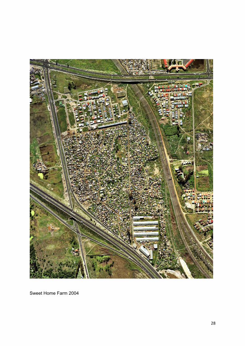
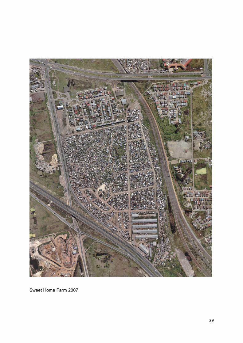
Time Series Photographs of Sweet Home Farm illustrating how the settlement has developed over time
Sweet Home farm 1998

27
Sweet Home Farm 2000
28
Sweet Home Farm 2004
29
Sweet Home Farm 2007