shamrock station irrigation project - epa wa · shamrock station irrigation project supplementary...
TRANSCRIPT
Shamrock Station Irrigation Project
Section 38 referral supplementary report
September 2017
Prepared for Argyle Cattle Company Pty Ltd by Phoenix Environmental Sciences Pty Ltd
57 Woodend Road, Sheidow Park, South Australia 5158
Telephone: 0455 477 655
Shamrock Station Irrigation Project supplementary report
Argyle Cattle Company Pty Ltd i
Shamrock Station Irrigation Project
Section 38 referral – Supplementary Report
Argyle Cattle Compay Pty Ltd
21 September 2017
Document control
Version Author Reviewer Signature Date
Draft K. Crews C McDonald (ACC) 21 August 2017
Final K. Crews C McDonald (ACC) 21 September 2017
Limitations
This report has been prepared by Phoenix Environmental Sciences Pty Ltd (Phoenix) for Argyle Cattle Company Pty Ltd in accordance with the scope of services as agreed between the parties. The use of this report is solely for the purpose in which it has been prepared. Phoenix Environmental Sciences Pty Ltd accepts no responsibility for use beyond this purpose.
Phoenix has relied on third party data to prepare this report. Unless otherwise stated, Phoenix has not verified the accuracy or completeness of the data. To the extent that the statements in this report are based, in whole or in part, on third party data, those statements are dependent on the accuracy and completeness of the data. Phoenix will not be held liable in relation to any incorrect statements should any data on which the statements are based be found to be incorrect.
Shamrock Station Irrigation Project supplementary report
Phoenix Environmental Sciences Pty Ltd ii
Contents 1 INTRODUCTION ........................................................................................................................................... 1
1.1 Purpose and scope .............................................................................................................................. 1
1.2 Proponent ............................................................................................................................................ 1
1.3 Environmental impact assessment process ........................................................................................ 4
1.4 Other approvals and regulation .......................................................................................................... 4
2 THE PROPOSAL ............................................................................................................................................ 5
2.1 Background .......................................................................................................................................... 5
2.2 Justification .......................................................................................................................................... 5
2.3 Proposal description ............................................................................................................................ 5
2.4 Local and regional context .................................................................................................................. 7
2.4.1 Physical environment .................................................................................................................. 8
2.4.2 Biological features ..................................................................................................................... 18
2.4.3 Project staging ........................................................................................................................... 25
3 STAKEHOLDER ENGAGEMENT ................................................................................................................... 26
4 ENVIRONMENTAL PRINCIPLES AND FACTORS ........................................................................................... 30
4.1 Principles ........................................................................................................................................... 30
4.2 Flora and vegetation .......................................................................................................................... 31
4.2.1 EPA objective ............................................................................................................................. 31
4.2.2 Policy and guidance ................................................................................................................... 31
4.2.3 Receiving environment .............................................................................................................. 31
4.2.4 Potential impacts ....................................................................................................................... 36
4.2.5 Assessment of impacts .............................................................................................................. 36
4.2.6 Mitigation .................................................................................................................................. 40
4.2.7 Predicted outcome .................................................................................................................... 41
4.3 Terrestrial fauna ................................................................................................................................ 41
4.3.1 EPA objective ............................................................................................................................. 41
4.3.2 Policy and guidance ................................................................................................................... 41
4.3.3 Receiving environment .............................................................................................................. 41
4.3.4 Potential impacts ....................................................................................................................... 43
4.3.5 Assessment of impacts .............................................................................................................. 43
4.3.6 Mitigation .................................................................................................................................. 45
4.3.7 Predicted outcome .................................................................................................................... 46
4.4 Hydrological processes ...................................................................................................................... 46
4.4.1 EPA objective ............................................................................................................................. 46
4.4.2 Policy and guidance ................................................................................................................... 46
4.4.3 Receiving environment .............................................................................................................. 46
4.4.4 Potential impacts ....................................................................................................................... 48
4.4.5 Assessment of impacts .............................................................................................................. 48
4.4.6 Mitigation .................................................................................................................................. 49
4.4.7 Predicted outcome .................................................................................................................... 50
5 OTHER ENVIRONMENTAL FACTORS .......................................................................................................... 50
6 MATTERS OF NATIONAL ENVIRONMENTAL SIGNIFICANCE ...................................................................... 54
Shamrock Station Irrigation Project supplementary report
Phoenix Environmental Sciences Pty Ltd iii
7 HOLISTIC IMPACT ASSESSMENT ................................................................................................................ 54
REFERENCES ...................................................................................................................................................... 55
APPENDICES ....................................................................................................................................................... 58
List of Figures
Figure 1-1 Regional location ......................................................................................................................... 2 Figure 1-2 Proposal Development Envelope and indicative work area ........................................................ 3 Figure 2-1 Land systems and surface geology .............................................................................................. 9 Figure 2-2 Hydrological values .................................................................................................................... 10 Figure 2-3 Injudinah Swamp (a, b, c – 28 Oct 2014; d – 21&27 May 2016) ............................................... 12 Figure 2-4 Canning basin, including sub-basins (from Paul et al. 2013) ..................................................... 13 Figure 2-5 Geological cross sections of the La Grange area (from Paul et al. 2013) .................................. 14 Figure 2-6 Conceptual model for the Broome Sandstone aquifer in the La Grange groundwater area
(from IGS 2017).......................................................................................................................... 15 Figure 2-7 Hydrogeological map of the La Grange sub area showing water table contours, depth to water
table and location of AEM-mapped salt water interface (from IGS 2017) ................................ 16 Figure 2-8 Site photos showing representative vegetation in Develpoment Envelope ............................. 19 Figure 2-9 Vegetation types and Priority Flora locations .......................................................................... 20 Figure 2-10 Vegetation condition ................................................................................................................. 21 Figure 2-11 Regional scale vegetation mapping (Shepherd et al. 2002; after Beard) and significant
ecological communities ............................................................................................................. 22 Figure 2-12 Fauna habitats and conservation significant fauna ................................................................... 24 Figure 4-1 Records and indicative habitat extent for Polymeria sp. Broome............................................. 35
List of Tables
Table 1-1 Other approvals and regulation ...................................................................................................... 4 Table 2-1 Summary of the Proposal ................................................................................................................ 6 Table 2-2 Location and proposed extent of physical and operational elements ............................................ 7 Table 2-3 Existing groundwater users in the vicinity of the Development Envelope (IGS 2017) .................. 17 Table 2-4 Conservation significant terrestrial fauna species reported from or potentially occurring in the
Development Envelope ................................................................................................................. 25 Table 3-1 Stakeholder consultation .............................................................................................................. 27 Table 4-1 EP Act principles ............................................................................................................................ 30 Table 4-2 Vegetation types, extent and calculated impacts ......................................................................... 38 Table 4-3 Conservation significant terrestrial fauna species reported from or potentially occurring in the
Development Envelope ................................................................................................................. 43 Table 4-4 Existing groundwater users in the vicinity of the Development Envelope (IGS 2017) .................. 48 Table 5-1 Other environmental factors ......................................................................................................... 51
List of Appendices
Appendix 1 Hydrogeological assessment Appendix 2 Flora and fauna assessment Appendix 3 Stakeholder correspondence Appendix 4 Draft Environmental Management Plan provisions Appendix 5 Subterranean fauna desktop assessment Appendix 6 Fertiliser and chemical application
Shamrock Station Irrigation Project supplementary report
Phoenix Environmental Sciences Pty Ltd 1
1 INTRODUCTION
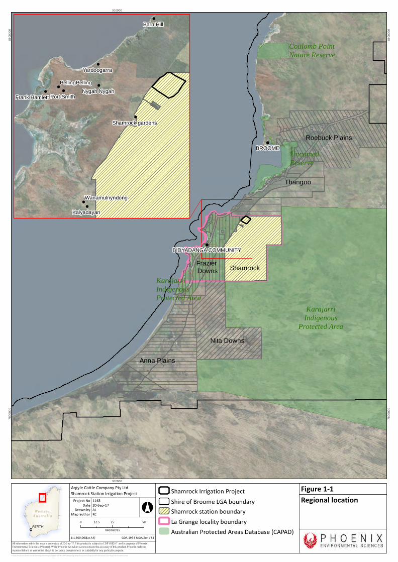
1.1 PURPOSE AND SCOPE Argyle Cattle Company Pty Ltd (ACC) is seeking approval to develop the Shamrock Station Irrigation Project (the Proposal) located 64 km south of Broome, Western Australia , or approximately 130 km by road (Figure 1-1). The Proposal is situated within Shamrock Pastoral Station on the Great Northern Highway in the locality of La Grange (Figure 1-1).
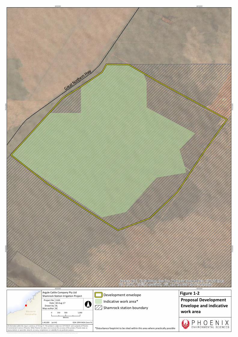
The Proposal has a Disturbance Footprint of up to 1,200 ha (comprising 650 ha of clearing and 550 ha of vegetation buffer) within a Development Envelope of 2,560 ha (Figure 1-2). The Disturbance Footprint will be constrained to the indicative work area (Figure 1-2) as far as practicable.
The Proposal includes the development of approximately 12 centre-pivot irrigation areas and surrounding vegetation buffers, 12 groundwater abstraction bores, 17 monitoring bores (11 already established), one surface water monitoring site, access tracks and supporting infrastructure
This Supplementary Report has been prepared to support the referral of the Proposal to the Environmental Protection Authority (EPA) under Section 38(1) of the Environmental Protection Act 1986 (EP Act). It provides information on the Proposal, the existing environment, preliminary key environmental factors and stakeholder consultation.
1.2 PROPONENT The proponent for the Shamrock Station Irrigation Project is Argyle Cattle Company Pty Ltd (ACC). Contact details for the proponent:
Mr Dale Champion
Argyle Cattle Company Pty Ltd
Phone: 0404 446 069
Email: [email protected]
P.O. Box 216
BRIGHTON SA 5048
ABN: 98 613 455 379
ACN: 613 455 379
Wes ter nAus t r al ia
PERTH
All information within this map is current as of 20-Sep-17. This product is subject to COPYRIGHT and is property of PhoenixEnvironmental Sciences (Phoenix). While Phoenix has taken care to ensure the accuracy of this product, Phoenix make norepresentations or warranties about its accuracy, completeness or suitability for any particular purpose.
!
!
!
Unnamed Reserve
KarajarriIndigenousProtected Area
KarajarriIndigenous
Protected Area
Coulomb PointNature Reserve
BROOME
BIDYADANGA COMMUNITY
300000
300000
7800
000
7800
000
8100
000
8100
000
P:\GIS\Projects\ShamrockStationIrrigationProject\1163-SIP-AC-APP\Mapping\MapDocuments\Figures\EP Act\new\1163-Regional location.mxd
Shamrock Irrigation ProjectShire of Broome LGA boundaryShamrock station boundaryLa Grange locality boundaryAustralian Protected Areas Database (CAPAD)
0 25 5012.5Kilometres
1:1,500,000
Argyle Cattle Company Pty LtdShamrock Station Irrigation Project
Map authorDrawn by
GDA 1994 MGA Zone 51
°
(at A4)
20-Sep-17DateProject No 1163
ALKC
Regional locationFigure 1-1
!
!
!
!
!
!
!
!
!
Barn Hill
Kalyadayan
Port Smith
Yardoogarra
Nygah NygahFrank Hamlett
Wanamulnyndong
PellingPelling
Shamrock gardens
Anna Plains
Nita Downs
Frazier Downs
Thangoo
Roebuck Plains
Shamrock
Wes ter nAus t r al ia
All information within this map is current as of 18-Aug-17. This product is subject to COPYRIGHT and is property of PhoenixEnvironmental Sciences (Phoenix). While Phoenix has taken care to ensure the accuracy of this product, Phoenix make norepresentations or warranties about its accuracy, completeness or suitability for any particular purpose.
Great Northern Hwy
Source: Esri, DigitalGlobe, GeoEye, Earthstar Geographics, CNES/AirbusDS, USDA, USGS, AeroGRID, IGN, and the GIS User Community
400000
400000
405000
405000
7950
000
7950
000
7955
000
7955
000
P:\GIS\Projects\ShamrockStationIrrigationProject\1163-SIP-AC-APP\Mapping\MapDocuments\Figures\EP Act\1163-ConceptualProjectLayout.mxd
0 500 1,000250Metres
Development envelopeIndicative work area*Shamrock station boundary
1:40,000
Argyle Cattle Company Pty LtdShamrock Station Irrigation Project
Map authorDrawn by
GDA 1994 MGA Zone 51
°
(at A4)
18-Aug-17DateProject No 1163
ALKC
Proposal DevelopmentEnvelope and indicativework area
Figure 1-2
*Disturbance fooptrint to be sited within this area where practically possible
Shamrock Station Irrigation Project supplementary report
Phoenix Environmental Sciences Pty Ltd 4
1.3 ENVIRONMENTAL IMPACT ASSESSMENT PROCESS The Proposal has been referred to the Environmental Protection Authority under s 38(1) of Part IV of the Environmental Protection Act 1986 (EP Act). This Supplementary Report has been prepared in accordance with the EPA’s Instructions on how to prepare an Environmental Review Document (EPA no date) with the intention of providing sufficient information for the EPA to assess the Proposal based on referral information as per section 2.3.1 of the Environmental Impact Assessment (Part IV Divisions 1 and 2) Administrative Procedures 2016 (Western Australian Government 2016).
The Proposal was referred to the Australian Government Minister for the Environment and Energy under the Environment Protection and Biodiversity Conservation Act 1999 (EPBC Act) on 7 August 2017 (EPBC 2017/8004). The referral was made available for public comment on 7 August for a two week period. A determination has not yet been made on the EPBC referral. On 21 September, ACC submitted a response to a request by DoEE for additional information.
1.4 OTHER APPROVALS AND REGULATION
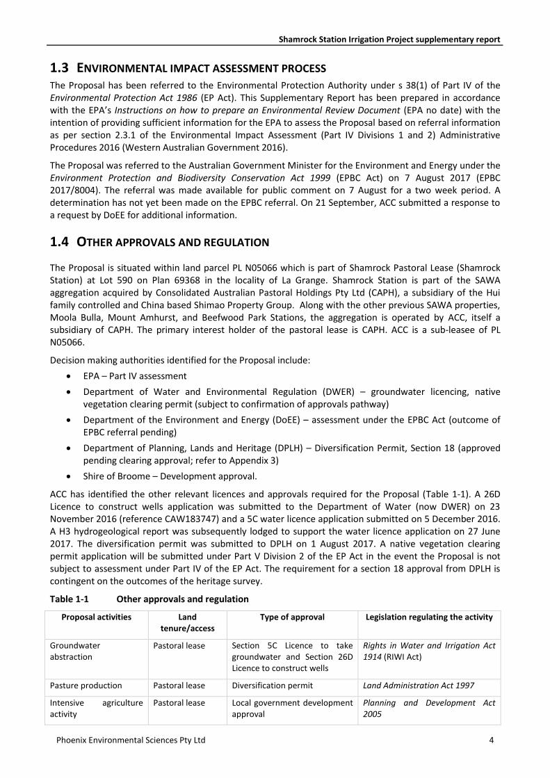
The Proposal is situated within land parcel PL N05066 which is part of Shamrock Pastoral Lease (Shamrock Station) at Lot 590 on Plan 69368 in the locality of La Grange. Shamrock Station is part of the SAWA aggregation acquired by Consolidated Australian Pastoral Holdings Pty Ltd (CAPH), a subsidiary of the Hui family controlled and China based Shimao Property Group. Along with the other previous SAWA properties, Moola Bulla, Mount Amhurst, and Beefwood Park Stations, the aggregation is operated by ACC, itself a subsidiary of CAPH. The primary interest holder of the pastoral lease is CAPH. ACC is a sub-leasee of PL N05066.
Decision making authorities identified for the Proposal include:
• EPA – Part IV assessment
• Department of Water and Environmental Regulation (DWER) – groundwater licencing, native vegetation clearing permit (subject to confirmation of approvals pathway)
• Department of the Environment and Energy (DoEE) – assessment under the EPBC Act (outcome of EPBC referral pending)
• Department of Planning, Lands and Heritage (DPLH) – Diversification Permit, Section 18 (approved pending clearing approval; refer to Appendix 3)
• Shire of Broome – Development approval.
ACC has identified the other relevant licences and approvals required for the Proposal (Table 1-1). A 26D Licence to construct wells application was submitted to the Department of Water (now DWER) on 23 November 2016 (reference CAW183747) and a 5C water licence application submitted on 5 December 2016. A H3 hydrogeological report was subsequently lodged to support the water licence application on 27 June 2017. The diversification permit was submitted to DPLH on 1 August 2017. A native vegetation clearing permit application will be submitted under Part V Division 2 of the EP Act in the event the Proposal is not subject to assessment under Part IV of the EP Act. The requirement for a section 18 approval from DPLH is contingent on the outcomes of the heritage survey.
Table 1-1 Other approvals and regulation
Proposal activities Land tenure/access
Type of approval Legislation regulating the activity
Groundwater abstraction
Pastoral lease Section 5C Licence to take groundwater and Section 26D Licence to construct wells
Rights in Water and Irrigation Act 1914 (RIWI Act)
Pasture production Pastoral lease Diversification permit Land Administration Act 1997
Intensive agriculture activity
Pastoral lease Local government development approval
Planning and Development Act 2005
Shamrock Station Irrigation Project supplementary report
Phoenix Environmental Sciences Pty Ltd 5
2 THE PROPOSAL
2.1 BACKGROUND
Consultation on the Proposal was undertaken informally with the OEPA between April and July 2017 and the Proposal is being referred in response to the preliminary OEPA feedback.
2.2 JUSTIFICATION Shamrock Station is located within the area covered by the Department of Agriculture and Food’s La Grange project which was established in 2012 to investigate opportunities for irrigated agricultural development in the La Grange region.
The fodder will be used to enhance the capacity of ACC’s aggregation of stations to maximise weight gain for livestock exported from the region, increase flexibility of operation and ensure security of both fodder and livestock supply through seasonal variations.
Developing an intensive fodder crop area on the station will reduce stock grazing pressure on the remainder of Shamrock Station, which is anticipated to have a positive environmental benefit on the rangeland ecosystems of the lease.
ACC has undertaken an assessment of site location options for the Proposal within Shamrock Station. Initial investigations considered three alternate areas within Shamrock Station, including the current location at the northern boundary of Shamrock Station and and two areas further south. A key factor in the decision to select the northern area as the proposed site was the identification during early hydrogeological investigations of a potential groundwater dependent ecosystem, Injudinah Swamp, within close proximity to the southern end of Shamrock Station that might be impacted by groundwater drawdown. The northern area was selected as it was furtherest from Injudinah Swamp. Other key factors influencing site selection were depth to water table, suitability of soils, proximity to other users, highway access and existing infrastructure.
The Development Envelope was later further refined based on environmental values identified in biological surveys with the aim of avoiding significant biological values as far as practicable.
The final site layout will need to consider several factors including the outcome of a heritage survey planned for late August, feedback from DWER on the H3 Hydrogeological Assessment completed for the Proposal, possible surface hydrology and pivot design itself. Therefore, a final proposal footprint has not yet been determined; however, ACC is endeavouring to constrain the footprint to the indicative work area shown in Figure 1-2 to minimise disturbance to significant flora records and fauna habitat.
The location of the Proposal is in the northwest corner of the station directly adjacent to the Great Northern Highway, providing logistical advantage in comparison to more remote parts of the station, and containing some existing access tracks which will utilised in the project layout and reduce vegetation clearing requirements.
2.3 PROPOSAL DESCRIPTION
The Proposal is located on Shamrock Station (Figure 1-1). A summary of the Proposal is provided in Table 2-1. Key characteristics of the Proposal are described in Table 2-2.
Argyle Cattle Company Pty Ltd (ACC) proposes to develop the Shamrock Station Irrigation Project on Shamrock Station in the the West Kimberley region of Western Australia. The Proposal entails the production of irrigated fodder for station use.
ACC will construct up to thirteen circular irrigation pivots that will be used to produce irrigated fodder principally as a Rhodes Grass stand and graze operation, possibly supplemented by oats and forage sorghum depending on seasonal conditions and livestock demand. Water supply to the pivots will be sourced from the Broome Sandstone Aquifer. Hay may also be produced depending on seasonal and aggregation demand
Shamrock Station Irrigation Project supplementary report
Phoenix Environmental Sciences Pty Ltd 6
which will be used within the aggregation of stations owned by CAPH for station use. No produce is intended for sale to external parties at this time.
The key components of the Proposal are:
• clearing up to 650 ha by mechanical clearing for pivots, access tracks and irrigation infrastructure
• installation of 11–12 groundwater abstraction bores (in addition to one already established) and up to 4 monitoring bores (in addition to six already established)
• construction of 12–13 circular irrigation pivots of up to 42.5 ha each (maximum 368 m radius, including 5–10 m buffer)
• construction of supporting infrastructure, including solar/diesel hybrid pumps
• establishing and maintaining a 50–100 m square fenced vegetation buffer around each pivot, up to 550 ha in total
• soil preparation, fertiliser application and seeding of fodder crop such as Rhodes grass, oats and sorghum within pivots
• abstraction of up to 9.5 GL of groundwater annually from the Broome Sandstone Aquifer to supply the irrigation system
• “stand and graze” operations within the pivot areas, entailing onsite rotational stocking of cattle from Shamrock Station and other stations owned by ACC
• baling of surplus fodder for internal use on ACC stations.
The pivot irrigation system will utilise technology where possible to enable accurate water and nutrient application. Monitoring will be undertaken to determine any adjustments required to the application regime. Water requirements will be calculated based on soil moisture content, evaporation and transpiration rates and optimal requirements for each irrigation species. Nutrient application requirements will be determined through soil and pasture analysis.
Once the area is in production it will be managed using annual and perennial cropping and grazing techniques. Ground ground cover will be maintained as much as practically possible.
Table 2-1 Summary of the Proposal
Proposal title Shamrock Station Irrigation Project
Proponent name Argyle Cattle Company Pty Ltd
Short description Argyle Cattle Company Pty Ltd (ACC) is seeking to develop a pivot irrigation project for the production of irrigated pasture and fodder to support intensive cattle grazing at Shamrock Station, located in the the West Kimberley region of Western Australia.
Shamrock Station Irrigation Project supplementary report
Phoenix Environmental Sciences Pty Ltd 7
Table 2-2 Location and proposed extent of physical and operational elements
Element Location Proposed extent
Physical elements
Irrigation pivots and supporting infrastructure
Indicative work area
Up to 650 ha in total.
Fenced vegetation buffers Indicative work area as far as possible
Up to 550 ha in total
Groundwater abstraction bores Indicative work area
Approximately 12 (one already established)
Monitoring bores Figure 2-2 Approximately 17 (11 already established)
Operational elements
Groundwater abstraction Indicative work area
Frequency and duration of watering will be dependent on a number of factors including crop water use, rainfall and irrigation system design.
Maximum localised extraction rate – approximately 300 L/sec.
Maximum total annual abstraction – 9.467 GL.
Power supply to pump Proposed solar/diesel hybrid system – approximately 700 panels.
2.4 LOCAL AND REGIONAL CONTEXT
Shamrock Station is situated in the Pindanland subregion (DAL02) of the Dampierland bioregion, as per the Interim Biogeographic Regionalisation of Australia. Adjacent pastoral leases are Thangoo Station to the north of Shamrock Station, Nita Downs to the south and Frazier Downs to the west. The Development Envelope is situated approximately 12.5 km from the coast. The topography between the Development Envelope and the coastline transitions from flat sandplain to an undulating sandplain with steep coastal gullies in parts.
Shamrock Gardens, a small irrigated agriculture project, is the closest settlement to the Development Envelope, located 8.2 km south (Figure 1-1). Bidyadanga Aboriginal Community, with a population of ~750, is located 35 km to the southwest and Port Smith Caravan Park is located 24.8 km to the west (Figure 1-1). Several small aboriginal settlements ranging from seasonal to permanent sites of none to five houses are located within 35 km of the Development Envelope: Nygah Nygah , Yardoogarra and Wanamulnyndong, Pelling Pelling and Kalyadayan (Figure 1-1).
Shamrock Station is surrounded by Karajarri Indigenous Protected Area (IPA) on its eastern and western boundaries, overlapping wth Frazier Downs in the latter instance (Figure 1-1). IPAs recognise Aboriginal people as land owners and managers and support them to look after biodiversity hotspots and highly sensitive areas (Kimberley Land Council 2017). They are formally recognised through the National Reserve System of protected areas. The Karajarri IPA, was declared by the Karajarri Traditional Owners in 2014 and covers 24,797 km2 of the southern Kimberley, extending from the dunes of the Great Sandy Desert, to coastal shrublands and encompassing Eighty Mile Beach. It is intended to provide a formal structure for the traditional owners to manage threats, promote conservation and protect biodiversity values.
Shamrock Station Irrigation Project supplementary report
Phoenix Environmental Sciences Pty Ltd 8
2.4.1 Physical environment
2.4.1.1 Surface geology and soils
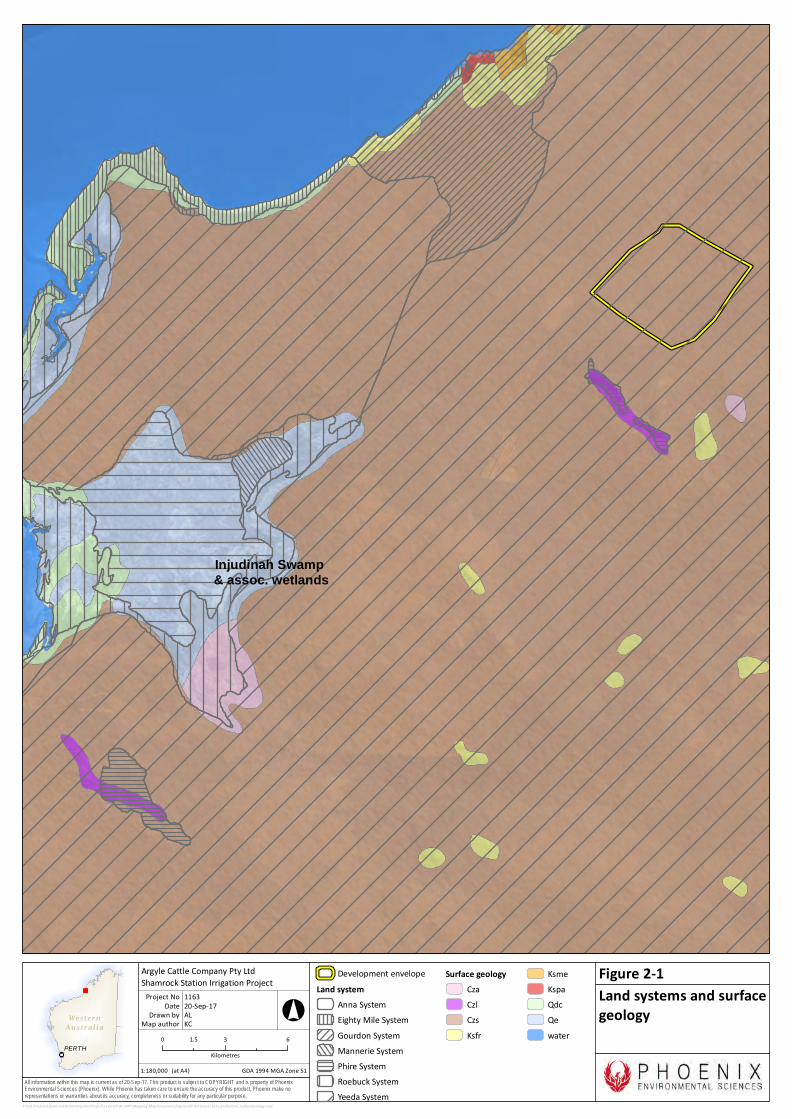
The Pindanland subregion consists of sandplains with pindan vegetation, alluvial plains with tree savannas and quarternary marine deposits on coastal plains with magroves and samphire (Graham 2001). The Development Envelope is representative of the former; sandplains with pindan vegetation. The surface geology of Shamrock Station is dominated by Quaternary deposits, specifically Aeolian deposits of fine to medium red sands and silts (Figure 2-1) (Gibson 1983). The Development Envelope is predominantly sandplain with sandy-loamy red-brown soils (Phoenix 2017). The Development Envelope falls within the Yeeda land system (Figure 2-1), which is described as sandplains and occasional dunes with shrubby spinifex grasslands or pindan woodlands; sandplains with deep red and yellow sands (Schoknecht & Payne 2011).
2.4.1.2 Topography
The landscape in the western portion of the La Grange Groundwater north subarea ranges from flat coastal plains in the west to a gently undulating Aeolian sandplain that rises over 200 m in the east. Other physiographic features of this region include scattered hills and mesas, laterite rises and claypans. Topographic elevations across Shamrock Station range from approximately 30 m AHD to 150 m AHD. The Development Envelope, is a gently sloping plain ranging from approximately 40 m AHD to 70 m AHD.
2.4.1.3 Surface water
There is no permanent surface water on or in the vicinity of Shamrock Station. The station is criss-crossed with several ephemeral drainage lines; two of these run through the Development Envelope; however are very minor and do not support riparian vegetation.
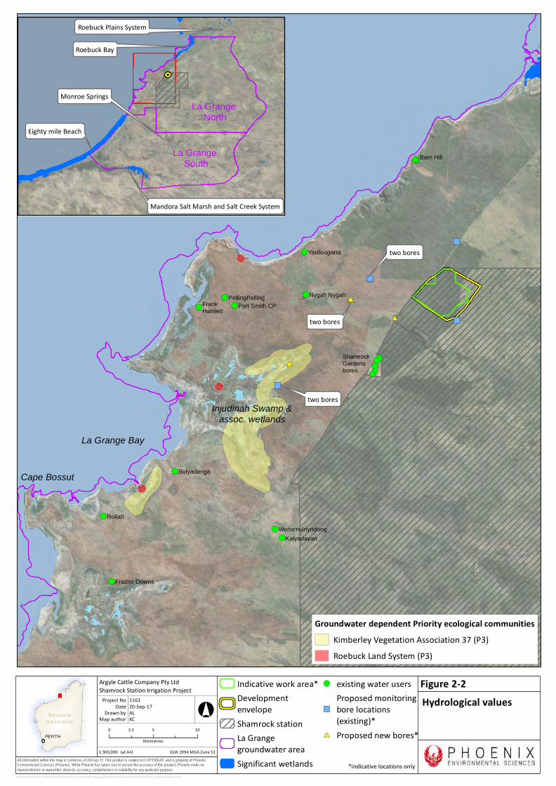
Nine wetlands in the north-western Sandy Desert (within a 150 km radius of the Development Envelope) are
ecologically significant according to V & C Semeniuk Research Group (2000). Four of these are also listed as
of conservation value nationally or internationally, i.e. they are Ramsar wetlands and/or are on the
Australian Directory of Important Wetlands (DIW) (Figure 2-2):
• Injudinah Swamp and associated wetlands – 10 km south-west of the Development Envelope
• Roebuck Bay (Ramsar, DIW) – approximately 21 km north
• Roebuck Plains System (DIW) – approximately 20 km north
• La Grange Bay – approximately 40 km south-west
• Cape Bossut embayment – approximately 50 km south-west
• Eighty Mile Beach (Ramsar, DIW) – approximately 80 km south
• Munro Springs – approximately 80 km south
• Mandora Salt Marsh (DIW) – approximately 145 km south
• Salt Creek System (part of the Mandora Marshes) – 145 km south.
All of these wetands except Injudinah Swamp are either marine systems and therefore not subject to impacts from the proposal (i.e. Cape Bossut, La Grange Bay) and/or too distant from the Development Envelope to be affected by modelled hydrological changes (IGS 2017).
Wes ter nAus t r al ia
PERTH
All information within this map is current as of 20-Sep-17. This product is subject to COPYRIGHT and is property of PhoenixEnvironmental Sciences (Phoenix). While Phoenix has taken care to ensure the accuracy of this product, Phoenix make norepresentations or warranties about its accuracy, completeness or suitability for any particular purpose.
P:\GIS\Projects\ShamrockStationIrrigationProject\1163-SIP-AC-APP\Mapping\MapDocuments\Figures\EP Act\new\1163-LandSystem_SurfaceGeology.mxd
Development envelopeLand system
Anna SystemEighty Mile SystemGourdon SystemMannerie SystemPhire SystemRoebuck SystemYeeda System
Surface geologyCzaCzlCzsKsfr
KsmeKspaQdcQewater0 3 61.5
Kilometres1:180,000
Argyle Cattle Company Pty LtdShamrock Station Irrigation Project
Map authorDrawn by
GDA 1994 MGA Zone 51
°
(at A4)
20-Sep-17DateProject No 1163
ALKC
Land systems and surfacegeology
Figure 2-1
Injudinah Swamp & assoc. wetlands
Wes ter nAus t r al ia
PERTH
All information within this map is current as of 20-Sep-17. This product is subject to COPYRIGHT and is property of PhoenixEnvironmental Sciences (Phoenix). While Phoenix has taken care to ensure the accuracy of this product, Phoenix make norepresentations or warranties about its accuracy, completeness or suitability for any particular purpose.
!(!(!(!(!(
!(
!(!(
!(
!(
!(
!(
!(
!(
!(
!(
!(
#*
#*
#*#*
")
")
")")
")")
Shamrock Gardens bores
Port Smith CP
Barn Hill
FrankHamlett
PellingPelling
Rollah
Bidyadanga
Wanamulnyndong
Nygah Nygah
Yardoogarra
Kalyadayan
Frazier Downs
P:\GIS\Projects\ShamrockStationIrrigationProject\1163-SIP-AC-APP\Mapping\MapDocuments\Figures\EP Act\new\1163_HydrologicalValues.mxd
Indicative work area*DevelopmentenvelopeShamrock stationLa Grangegroundwater areaSignificant wetlands
!( existing water users
")
Proposed monitoringbore locations(existing)*
#* Proposed new bores*0 5 102.5Kilometres
1:300,000
Argyle Cattle Company Pty LtdShamrock Station Irrigation Project
Map authorDrawn by
GDA 1994 MGA Zone 51
°
(at A4)
20-Sep-17DateProject No 1163
ALKC
Hydrological valuesFigure 2-2
Injudinah Swamp & assoc. wetlands
La Grange South
La Grange North
Groundwater dependent Priority ecological communitiesKimberley Vegetation Association 37 (P3)Roebuck Land System (P3)
Mandora Salt Marsh and Salt Creek System
Roebuck Bay
Roebuck Plains System
Eighty mile Beach
Cape Bossut
La Grange Bay
Monroe Springs
two bores
two bores
two bores
*indicative locations only
Shamrock Station Irrigation Project supplementary report
Phoenix Environmental Sciences Pty Ltd 11
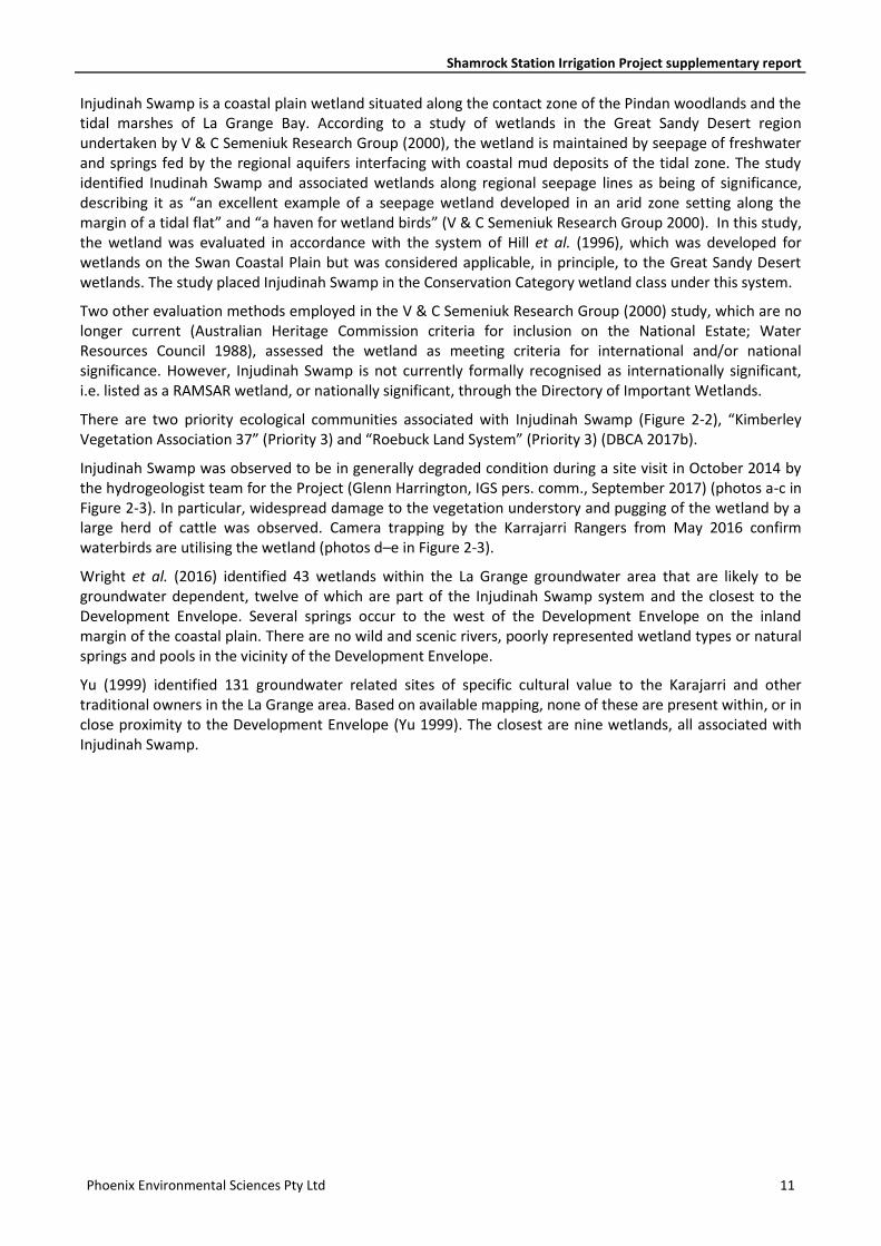
Injudinah Swamp is a coastal plain wetland situated along the contact zone of the Pindan woodlands and the tidal marshes of La Grange Bay. According to a study of wetlands in the Great Sandy Desert region undertaken by V & C Semeniuk Research Group (2000), the wetland is maintained by seepage of freshwater and springs fed by the regional aquifers interfacing with coastal mud deposits of the tidal zone. The study identified Inudinah Swamp and associated wetlands along regional seepage lines as being of significance, describing it as “an excellent example of a seepage wetland developed in an arid zone setting along the margin of a tidal flat” and “a haven for wetland birds” (V & C Semeniuk Research Group 2000). In this study, the wetland was evaluated in accordance with the system of Hill et al. (1996), which was developed for wetlands on the Swan Coastal Plain but was considered applicable, in principle, to the Great Sandy Desert wetlands. The study placed Injudinah Swamp in the Conservation Category wetland class under this system.
Two other evaluation methods employed in the V & C Semeniuk Research Group (2000) study, which are no longer current (Australian Heritage Commission criteria for inclusion on the National Estate; Water Resources Council 1988), assessed the wetland as meeting criteria for international and/or national significance. However, Injudinah Swamp is not currently formally recognised as internationally significant, i.e. listed as a RAMSAR wetland, or nationally significant, through the Directory of Important Wetlands.
There are two priority ecological communities associated with Injudinah Swamp (Figure 2-2), “Kimberley Vegetation Association 37” (Priority 3) and “Roebuck Land System” (Priority 3) (DBCA 2017b).
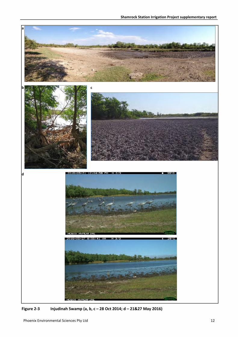
Injudinah Swamp was observed to be in generally degraded condition during a site visit in October 2014 by the hydrogeologist team for the Project (Glenn Harrington, IGS pers. comm., September 2017) (photos a-c in Figure 2-3). In particular, widespread damage to the vegetation understory and pugging of the wetland by a large herd of cattle was observed. Camera trapping by the Karrajarri Rangers from May 2016 confirm waterbirds are utilising the wetland (photos d–e in Figure 2-3).
Wright et al. (2016) identified 43 wetlands within the La Grange groundwater area that are likely to be groundwater dependent, twelve of which are part of the Injudinah Swamp system and the closest to the Development Envelope. Several springs occur to the west of the Development Envelope on the inland margin of the coastal plain. There are no wild and scenic rivers, poorly represented wetland types or natural springs and pools in the vicinity of the Development Envelope.
Yu (1999) identified 131 groundwater related sites of specific cultural value to the Karajarri and other traditional owners in the La Grange area. Based on available mapping, none of these are present within, or in close proximity to the Development Envelope (Yu 1999). The closest are nine wetlands, all associated with Injudinah Swamp.
Shamrock Station Irrigation Project supplementary report
Phoenix Environmental Sciences Pty Ltd 12
a
b
c
d
Figure 2-3 Injudinah Swamp (a, b, c – 28 Oct 2014; d – 21&27 May 2016)
Shamrock Station Irrigation Project supplementary report
Phoenix Environmental Sciences Pty Ltd 13
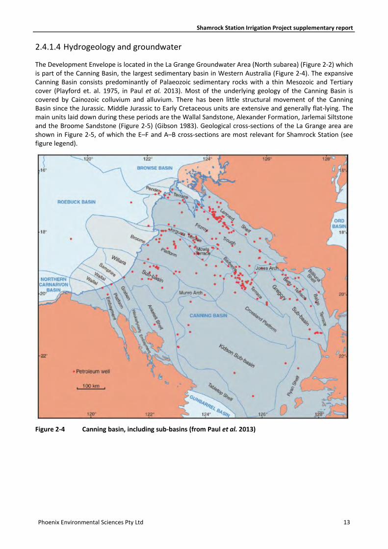
2.4.1.4 Hydrogeology and groundwater
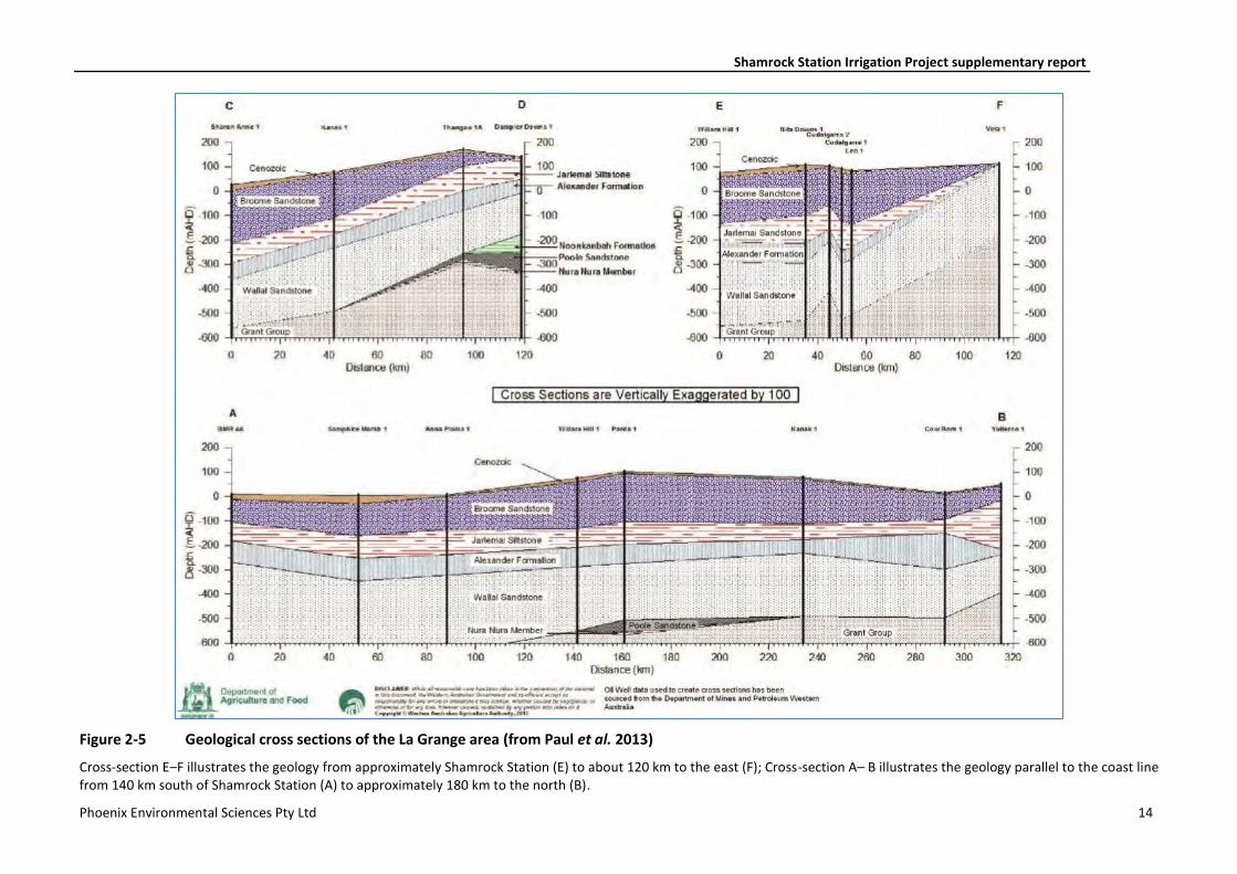
The Development Envelope is located in the La Grange Groundwater Area (North subarea) (Figure 2-2) which is part of the Canning Basin, the largest sedimentary basin in Western Australia (Figure 2-4). The expansive Canning Basin consists predominantly of Palaeozoic sedimentary rocks with a thin Mesozoic and Tertiary cover (Playford et. al. 1975, in Paul et al. 2013). Most of the underlying geology of the Canning Basin is covered by Cainozoic colluvium and alluvium. There has been little structural movement of the Canning Basin since the Jurassic. Middle Jurassic to Early Cretaceous units are extensive and generally flat-lying. The main units laid down during these periods are the Wallal Sandstone, Alexander Formation, Jarlemai Siltstone and the Broome Sandstone (Figure 2-5) (Gibson 1983). Geological cross-sections of the La Grange area are shown in Figure 2-5, of which the E–F and A–B cross-sections are most relevant for Shamrock Station (see figure legend).
Figure 2-4 Canning basin, including sub-basins (from Paul et al. 2013)
Shamrock Station Irrigation Project supplementary report
Phoenix Environmental Sciences Pty Ltd 14
Figure 2-5 Geological cross sections of the La Grange area (from Paul et al. 2013)
Cross-section E–F illustrates the geology from approximately Shamrock Station (E) to about 120 km to the east (F); Cross-section A– B illustrates the geology parallel to the coast line from 140 km south of Shamrock Station (A) to approximately 180 km to the north (B).
Shamrock Station Irrigation Project supplementary report
Phoenix Environmental Sciences Pty Ltd 15
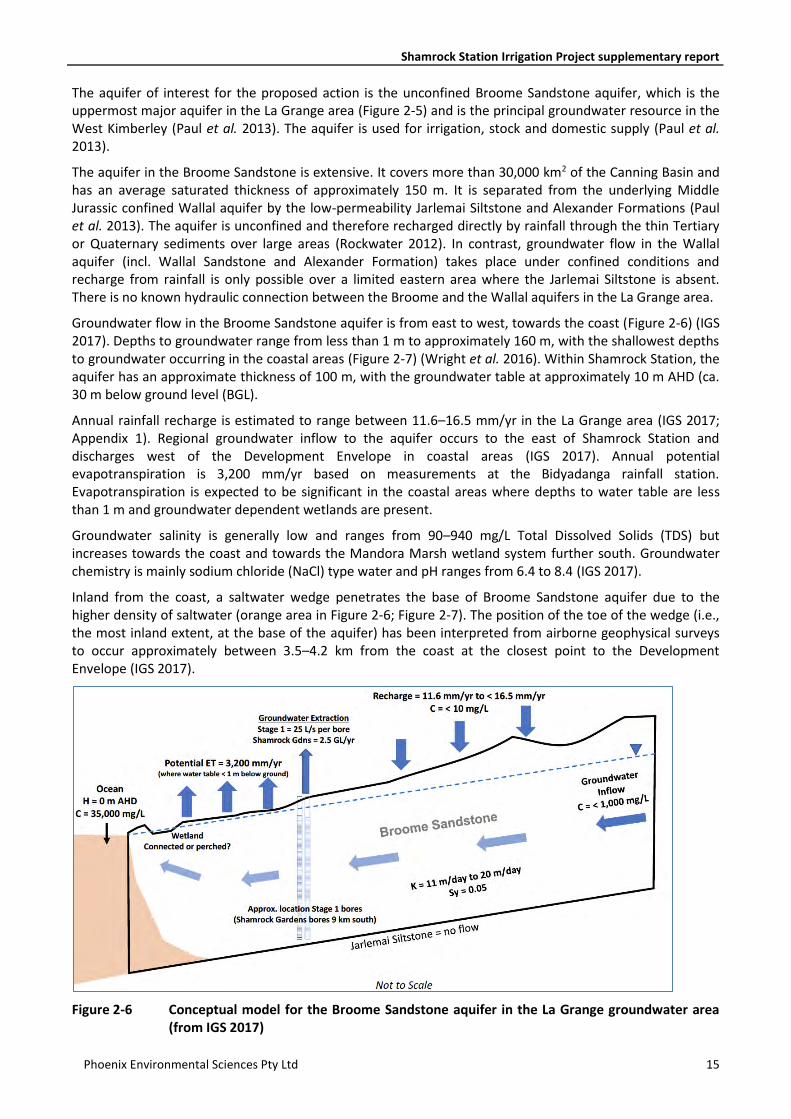
The aquifer of interest for the proposed action is the unconfined Broome Sandstone aquifer, which is the uppermost major aquifer in the La Grange area (Figure 2-5) and is the principal groundwater resource in the West Kimberley (Paul et al. 2013). The aquifer is used for irrigation, stock and domestic supply (Paul et al. 2013).
The aquifer in the Broome Sandstone is extensive. It covers more than 30,000 km2 of the Canning Basin and has an average saturated thickness of approximately 150 m. It is separated from the underlying Middle Jurassic confined Wallal aquifer by the low-permeability Jarlemai Siltstone and Alexander Formations (Paul et al. 2013). The aquifer is unconfined and therefore recharged directly by rainfall through the thin Tertiary or Quaternary sediments over large areas (Rockwater 2012). In contrast, groundwater flow in the Wallal aquifer (incl. Wallal Sandstone and Alexander Formation) takes place under confined conditions and recharge from rainfall is only possible over a limited eastern area where the Jarlemai Siltstone is absent. There is no known hydraulic connection between the Broome and the Wallal aquifers in the La Grange area.
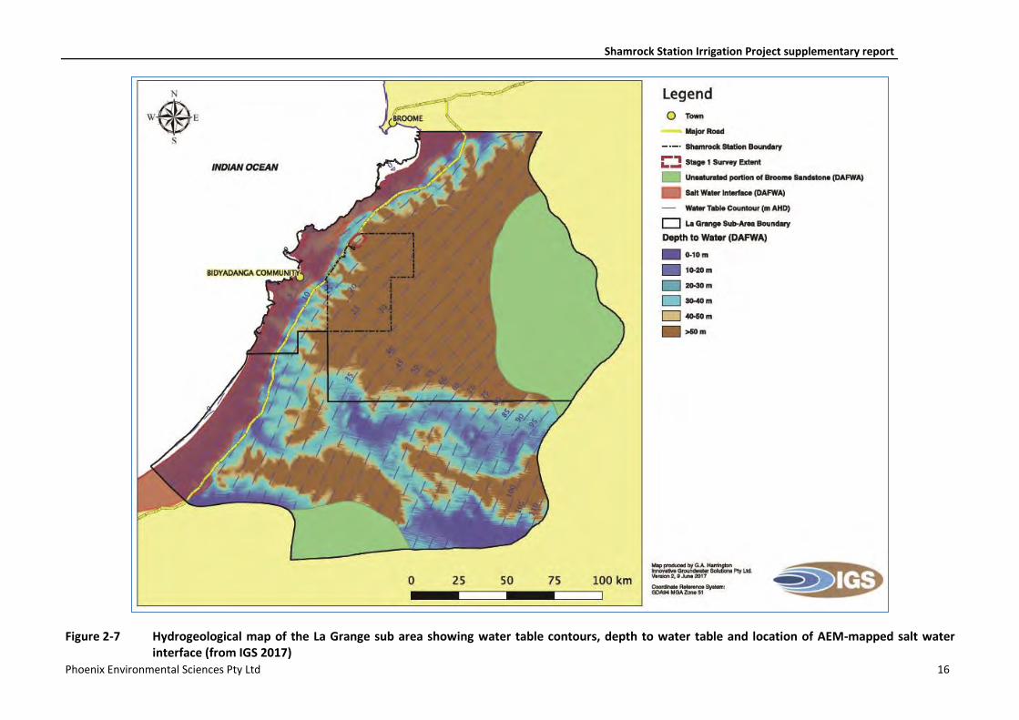
Groundwater flow in the Broome Sandstone aquifer is from east to west, towards the coast (Figure 2-6) (IGS 2017). Depths to groundwater range from less than 1 m to approximately 160 m, with the shallowest depths to groundwater occurring in the coastal areas (Figure 2-7) (Wright et al. 2016). Within Shamrock Station, the aquifer has an approximate thickness of 100 m, with the groundwater table at approximately 10 m AHD (ca. 30 m below ground level (BGL).
Annual rainfall recharge is estimated to range between 11.6–16.5 mm/yr in the La Grange area (IGS 2017; Appendix 1). Regional groundwater inflow to the aquifer occurs to the east of Shamrock Station and discharges west of the Development Envelope in coastal areas (IGS 2017). Annual potential evapotranspiration is 3,200 mm/yr based on measurements at the Bidyadanga rainfall station. Evapotranspiration is expected to be significant in the coastal areas where depths to water table are less than 1 m and groundwater dependent wetlands are present.
Groundwater salinity is generally low and ranges from 90–940 mg/L Total Dissolved Solids (TDS) but increases towards the coast and towards the Mandora Marsh wetland system further south. Groundwater chemistry is mainly sodium chloride (NaCl) type water and pH ranges from 6.4 to 8.4 (IGS 2017).
Inland from the coast, a saltwater wedge penetrates the base of Broome Sandstone aquifer due to the higher density of saltwater (orange area in Figure 2-6; Figure 2-7). The position of the toe of the wedge (i.e., the most inland extent, at the base of the aquifer) has been interpreted from airborne geophysical surveys to occur approximately between 3.5–4.2 km from the coast at the closest point to the Development Envelope (IGS 2017).
Figure 2-6 Conceptual model for the Broome Sandstone aquifer in the La Grange groundwater area (from IGS 2017)
Shamrock Station Irrigation Project supplementary report
Phoenix Environmental Sciences Pty Ltd 16
Figure 2-7 Hydrogeological map of the La Grange sub area showing water table contours, depth to water table and location of AEM-mapped salt water interface (from IGS 2017)
Shamrock Station Irrigation Project supplementary report
Phoenix Environmental Sciences Pty Ltd 17
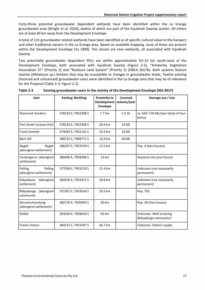
Forty-three potential groundwater dependent wetlands have been identified within the La Grange groundwater area (Wright et al. 2016), twelve of which are part of the Injudinah Swamp system. All others are at least 40 km away from the Development Envelope.
A total of 131 groundwater related wetlands have been identified as of specific cultural value to the Karajarri and other traditional owners in the La Grange area. Based on available mapping, none of these are present within the Development Envelope (Yu 1999). The closest are nine wetlands, all associated with Injudinah Swamp.
Two potentially groundwater dependent PECs are within approximately 10–15 km south-west of the Development Envelope, both associated with Injudinah Swamp (Figure 2-2), “Kimberley Vegetation Association 37” (Priority 3) and “Roebuck Land System” (Priority 3) (DBCA 2017b). Both systems feature teatree (Melaleuca sp.) thickets that may be susceptible to changes in groundwater levels. Twelve existing (licenced and unlicenced) groundwater users were identified in the La Grange area that may be of relevance for the Proposal (Table 2-3; Figure 2-2).
Table 2-3 Existing groundwater users in the vicinity of the Development Envelope (IGS 2017)
User Easting; Northing Proximity to Development
Envelope
Licensed volume/year
Average use / size
Shamrock Gardens 378154 E; 7952308 S 7.7 km 2.5 GL ca. 620–720 ML/year (total of four bores)
Port Smith Caravan Park 378154 E; 7952308 S 20.4 km 19 ML
Frank Hamlett 374093 E; 7952142 S 24.4 km 10 ML
Barn Hill 398722 E; 7968771 S 12.9 km 40 ML
Nygah Nygah (aboriginal settlement)
386207 E; 7953539 S 12.5 km Pop. 4 (two houses)
Yardoogarra (aboriginal settlement)
386046 E; 7958368 S 13 km Seasonal site (one house)
Pelling Pelling (aboriginal settlement)
377039 E; 7953219 S 21.4 km Unknown (not necessarily permanent)
Kalyadayan (aboriginal settlement)
383526 E; 7925971 S 30.8 km Unknown (not necessarily permanent)
Bidyadanga (aboriginal community
371367 E; 7933534 S 33.5 km Pop. 750
Wanamulnyndong (aboriginal settlement)
382720 E; 7926993 S 30 km Pop. 20 (five houses)
Rollah 363264 E; 7928426 S 43 km Unknown. Well servicing Bidyadanga community?
Frazier Downs 364215 E; 7921047 S 46.7 km Unkonwn. Station supply

Shamrock Station Irrigation Project supplementary report
Phoenix Environmental Sciences Pty Ltd 18
2.4.2 Biological features
2.4.2.1 Flora and vegetation
A flora and vegetation survey was undertaken concurrently with a terrestrial fauna survey within and in the vicinity of the Development Envelope in April–May 2017 (Phoenix 2017; Appendix 2). The flora and vegetation survey identified 114 species and subspecies representing 32 families and 78 genera present within the study area. The most prominent families recorded were Fabaceae (25 species), Malvaceae (13), Poaceae (10) and Proteaceae (6). No introduced flora species were recorded.
No flora species listed as Threatened under the EPBC Act were recorded during the survey. Three Priority Flora species were recorded in the study area during the survey: Tephrosia andrewii (P1), Polymeria sp. Broome (P1) Triodia caelestialis (P3).
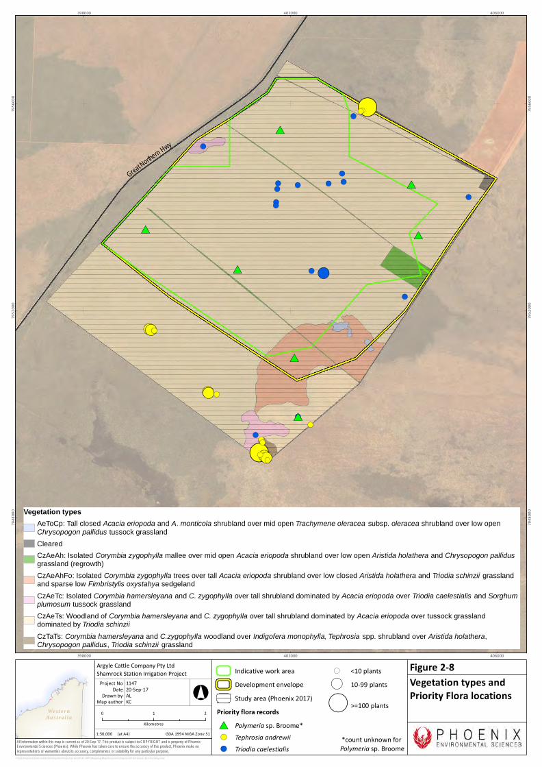
Six vegetation types were recorded in the study area of which five are present in the Development Envelope. (Figure 2-8; Figure 2-9). The majority of the Development Envelope (91%) is represented by a woodland of Corymbia hamersleyana and C. zygophylla over tall shrubland dominated by Acacia eriopoda over tussock grassland dominated by Triodia schinzii. The remainder was mapped as four shrublands, all dominated by Acacia eriopoda with mixed species mid to low shrublands over mixed tussock grasslands. One shrubland (Type 04, CzAeAh) comprised mainly ephemeral shrubs recolonising previously cleared areas.
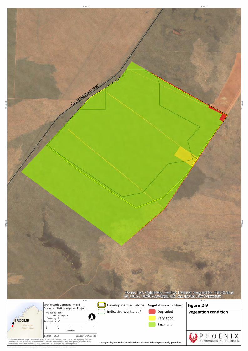
The condition of remnant native vegetation in the Development Envelope is Excellent according to the condition scale of the Trudgen (1988 in EPA 2016i), with regrowth of vegetation in previously cleared areas (including historic tracks) rated as Very Good (Phoenix 2017) (Figure 2-10). In July 2017, part of the Development Envelope was subject to a wildfire and subsequent backburning by the Shire of Broome to control the fire; the extent of the fire within the Development Envelope has not been mapped.
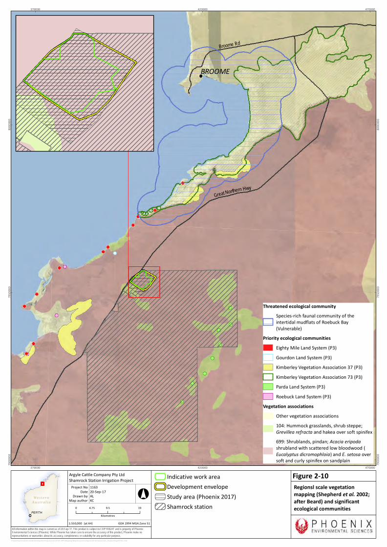
Regional scale vegetation mapping by Shepherd et al. (2002; after Beard) defined one vegetation association in the Development Envelope; Association 699 Acacia thicket with scattered low trees over spinifex Acacia eriopoda, Corymbia dichromophloia, Triodia pungens, T. bitextura. The vegetation types defined in the Development Envelope by the flora and vegetation survey (Phoenix 2017) are generally representative of this broad Pindan shrubland vegetation association which is extensively represented in the correspondingly named Pindanland subregion (4,928,779 ha) and has over 99% remaining according to Government of Western Australia (2016) (Figure 2-11).
The desktop review conducted for the survey determined that no threatened ecological communities (TECs) listed under the EPBC Act or the WC Act, priority ecological communities (PECs) listed by DBCA, or Environmentally Sensitive Areas are present within the study area. Six vegetation-related PECs were identified within a 40 km radius of the study area (Figure 2-11):
• Eighty Mile Land System (P3) 12 km west. Beach foredunes, longitudinal coastal dunes and sandy plains with tussock grasslands and spinifex grasslands.
• Gourdon Land System (P3) 9 km west. Sandplain and undulating lateritic country with steep coastal gullies supporting spinifex grasslands with scattered trees.
• Parda Land System (P3) 25 km east. Conical hills, stony ring plains, alluvial plains and shallow valleys supporting spinifex grasslands with sparse shrubs and trees.
• Roebuck Land System (P3) 20 km west and within Injudinah Swamp. Paleo-tidal coastal plains and tidal flats with saline soil supporting salt-water couch grasslands, samphire low shrublands, melaleuca.
• Kimberley Vegetation Association 37 (P3) 12 km southwest, part of Injudinah Swamp. As defined by John Beard’s vegetation mapping for the Kimberley (Beard 1979). Shrublands; teatree thicket.
• Kimberley Vegetation Association 73 (P3) 17 km north. As defined by John Beard’s vegetation mapping for the Kimberley (Beard 1979). Grasslands, tall bunch grass savanna, mitchell & blue grass. Unlikely to be relevant to study area
None of the PECs resemble vegetation of the study area.
Shamrock Station Irrigation Project supplementary report
Phoenix Environmental Sciences Pty Ltd 19
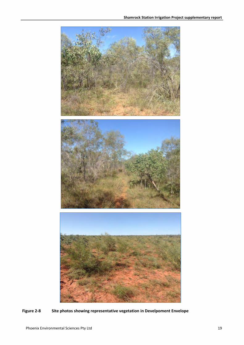
Figure 2-8 Site photos showing representative vegetation in Develpoment Envelope
Wes ter nAus t r al ia
All information within this map is current as of 20-Sep-17. This product is subject to COPYRIGHT and is property of PhoenixEnvironmental Sciences (Phoenix). While Phoenix has taken care to ensure the accuracy of this product, Phoenix make norepresentations or warranties about its accuracy, completeness or suitability for any particular purpose.
!(
!(!(
!(
!(
!(
!(!(
!(
!(
!(
!(
!(
!(!(
!(
!(
!(!(
!(
!(
!(
!(
!(
!(
#*
#*
#*
!(
#*
!(
!(#*
!(
#*
#*
!(
!(
!(
!(
!(Great Northern Hwy
398000
398000
402000
402000
406000
406000
7948
000
7948
000
7952
000
7952
000
7956
000
7956
000
P:\GIS\Projects\ShamrockStationIrrigationProject\1163-SIP-AC-APP\Mapping\MapDocuments\Figures\EP Act\new\1163-FloraVeg.mxd
Indicative work areaDevelopment envelopeStudy area (Phoenix 2017)
Priority flora records#* Polymeria sp. Broome*!( Tephrosia andrewii!( Triodia caelestialis
( <10 plants( 10-99 plants
( >=100 plants0 1 2
Kilometres1:50,000
Argyle Cattle Company Pty LtdShamrock Station Irrigation Project
Map authorDrawn by
GDA 1994 MGA Zone 51
°
(at A4)
20-Sep-17DateProject No 1147
ALKC
Vegetation types andPriority Flora locations
Figure 2-8
Vegetation typesAeToCp: Tall closed Acacia eriopoda and A. monticola shrubland over mid open Trachymene oleracea subsp. oleracea shrubland over low openChrysopogon pallidus tussock grasslandClearedCzAeAh: Isolated Corymbia zygophylla mallee over mid open Acacia eriopoda shrubland over low open Aristida holathera and Chrysopogon pallidusgrassland (regrowth)CzAeAhFo: Isolated Corymbia zygophylla trees over tall Acacia eriopoda shrubland over low closed Aristida holathera and Triodia schinzii grasslandand sparse low Fimbristylis oxystahya sedgelandCzAeTc: Isolated Corymbia hamersleyana and C. zygophylla over tall shrubland dominated by Acacia eriopoda over Triodia caelestialis and Sorghumplumosum tussock grasslandCzAeTs: Woodland of Corymbia hamersleyana and C. zygophylla over tall shrubland dominated by Acacia eriopoda over tussock grasslanddominated by Triodia schinziiCzTaTs: Corymbia hamersleyana and C.zygophylla woodland over Indigofera monophylla, Tephrosia spp. shrubland over Aristida holathera,Chrysopogon pallidus, Triodia schinzii grassland
*count unknown for Polymeria sp. Broome
!BROOME
Wes ter nAus t r al ia
All information within this map is current as of 20-Sep-17. This product is subject to COPYRIGHT and is property of PhoenixEnvironmental Sciences (Phoenix). While Phoenix has taken care to ensure the accuracy of this product, Phoenix make norepresentations or warranties about its accuracy, completeness or suitability for any particular purpose.
Great Northern Hwy
Source: Esri, DigitalGlobe, GeoEye, Earthstar Geographics, CNES/AirbusDS, USDA, USGS, AeroGRID, IGN, and the GIS User Community
400000
400000
405000
405000
7950
000
7950
000
7955
000
7955
000
P:\GIS\Projects\ShamrockStationIrrigationProject\1163-SIP-AC-APP\Mapping\MapDocuments\Figures\EP Act\new\1163-7VegCond.mxd
0 1 20.5Kilometers
Development envelopeIndicative work area*
Vegetation conditionDegradedVery goodExcellent
1:50,000
Argyle Cattle Company Pty LtdShamrock Station Irrigation Project
Map authorDrawn by
GDA 1994 MGA Zone 51
°
(at A4)
20-Sep-17DateProject No 1163
ALKC
Vegetation conditionFigure 2-9
* Project layout to be sited within this area where practically possible
Wes ter nAus t r al ia
PERTH
All information within this map is current as of 20-Sep-17. This product is subject to COPYRIGHT and is property of PhoenixEnvironmental Sciences (Phoenix). While Phoenix has taken care to ensure the accuracy of this product, Phoenix make norepresentations or warranties about its accuracy, completeness or suitability for any particular purpose.
BROOME
Broome Rd
Great Northern Hwy
370000
370000
420000
420000
470000
4700007900
000
7900
000
7950
000
7950
000
8000
000
8000
000
P:\GIS\Projects\ShamrockStationIrrigationProject\1163-SIP-AC-APP\Mapping\MapDocuments\Figures\EP Act\new\1163_ShepherdVegPECTEC.mxd
Indicative work areaDevelopment envelopeStudy area (Phoenix 2017)Shamrock station0 9.5 194.75
Kilometres1:550,000
Argyle Cattle Company Pty LtdShamrock Station Irrigation Project
Map authorDrawn by
GDA 1994 MGA Zone 51
°
(at A4)
20-Sep-17DateProject No 1163
ALKC
Regionsl scale vegetationmapping (Shepherd et al. 2002;after Beard) and significantecological communities
Figure 2-10
104
Threatened ecological communitySpecies-rich faunal community of theintertidal mudflats of Roebuck Bay(Vulnerable)
Priority ecological communitiesEighty Mile Land System (P3)Gourdon Land System (P3)Kimberley Vegetation Association 37 (P3)Kimberley Vegetation Association 73 (P3)Parda Land System (P3)Roebuck Land System (P3)
Vegetation associationsOther vegetation associations104: Hummock grasslands, shrub steppe;Grevillea refracta and hakea over soft spinifex699: Shrublands, pindan; Acacia eripodashrubland with scattered low bloodwood (Eucalyptus dicromophloia) and E. setosa oversoft and curly spinifex on sandplain
Shamrock Station Irrigation Project supplementary report
Phoenix Environmental Sciences Pty Ltd 23
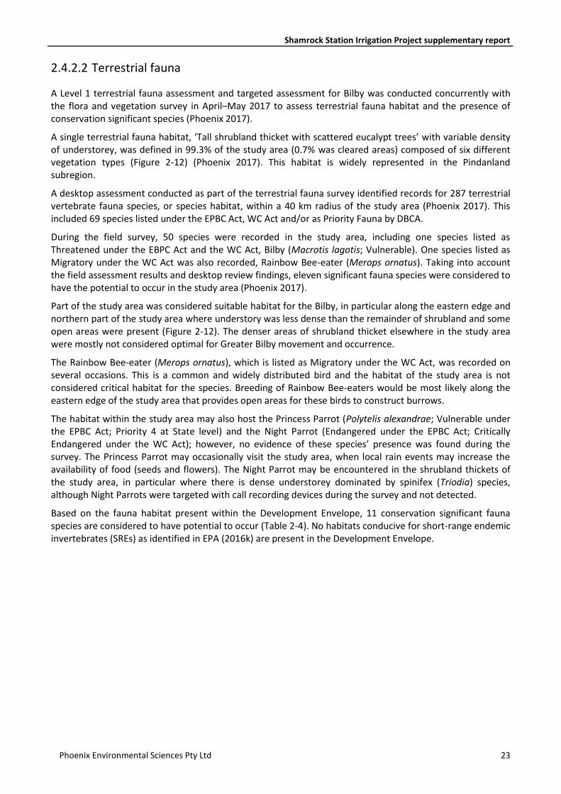
2.4.2.2 Terrestrial fauna
A Level 1 terrestrial fauna assessment and targeted assessment for Bilby was conducted concurrently with the flora and vegetation survey in April–May 2017 to assess terrestrial fauna habitat and the presence of conservation significant species (Phoenix 2017).
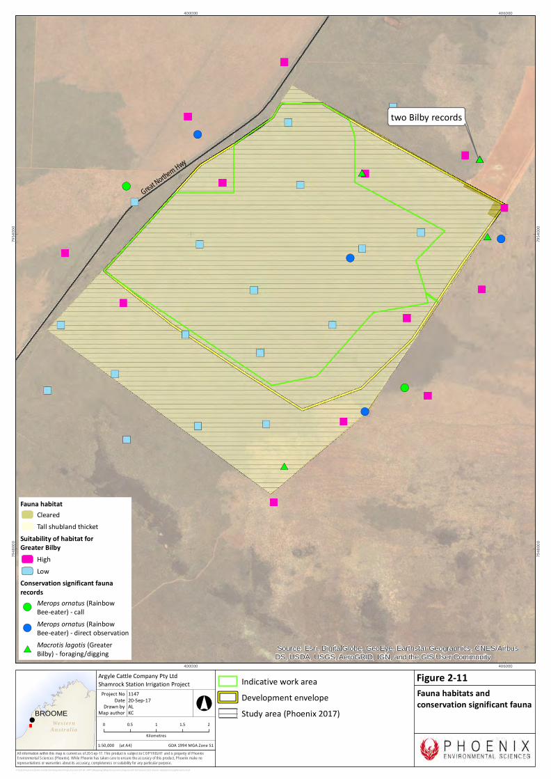
A single terrestrial fauna habitat, ‘Tall shrubland thicket with scattered eucalypt trees’ with variable density of understorey, was defined in 99.3% of the study area (0.7% was cleared areas) composed of six different vegetation types (Figure 2-12) (Phoenix 2017). This habitat is widely represented in the Pindanland subregion.
A desktop assessment conducted as part of the terrestrial fauna survey identified records for 287 terrestrial vertebrate fauna species, or species habitat, within a 40 km radius of the study area (Phoenix 2017). This included 69 species listed under the EPBC Act, WC Act and/or as Priority Fauna by DBCA.
During the field survey, 50 species were recorded in the study area, including one species listed as Threatened under the EBPC Act and the WC Act, Bilby (Macrotis lagotis; Vulnerable). One species listed as Migratory under the WC Act was also recorded, Rainbow Bee-eater (Merops ornatus). Taking into account the field assessment results and desktop review findings, eleven significant fauna species were considered to have the potential to occur in the study area (Phoenix 2017).
Part of the study area was considered suitable habitat for the Bilby, in particular along the eastern edge and northern part of the study area where understory was less dense than the remainder of shrubland and some open areas were present (Figure 2-12). The denser areas of shrubland thicket elsewhere in the study area were mostly not considered optimal for Greater Bilby movement and occurrence.
The Rainbow Bee-eater (Merops ornatus), which is listed as Migratory under the WC Act, was recorded on several occasions. This is a common and widely distributed bird and the habitat of the study area is not considered critical habitat for the species. Breeding of Rainbow Bee-eaters would be most likely along the eastern edge of the study area that provides open areas for these birds to construct burrows.
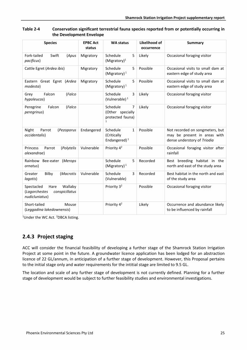
The habitat within the study area may also host the Princess Parrot (Polytelis alexandrae; Vulnerable under the EPBC Act; Priority 4 at State level) and the Night Parrot (Endangered under the EPBC Act; Critically Endangered under the WC Act); however, no evidence of these species’ presence was found during the survey. The Princess Parrot may occasionally visit the study area, when local rain events may increase the availability of food (seeds and flowers). The Night Parrot may be encountered in the shrubland thickets of the study area, in particular where there is dense understorey dominated by spinifex (Triodia) species, although Night Parrots were targeted with call recording devices during the survey and not detected.
Based on the fauna habitat present within the Development Envelope, 11 conservation significant fauna species are considered to have potential to occur (Table 2-4). No habitats conducive for short-range endemic invertebrates (SREs) as identified in EPA (2016k) are present in the Development Envelope.
!BROOME
Wes ter nAus t r al ia
All information within this map is current as of 20-Sep-17. This product is subject to COPYRIGHT and is property of PhoenixEnvironmental Sciences (Phoenix). While Phoenix has taken care to ensure the accuracy of this product, Phoenix make norepresentations or warranties about its accuracy, completeness or suitability for any particular purpose.
!(#*
#*
!(
#*
!(
#*#*
!(
!(
!( Great Northern Hwy
Source: Esri, DigitalGlobe, GeoEye, Earthstar Geographics, CNES/AirbusDS, USDA, USGS, AeroGRID, IGN, and the GIS User Community
400000
400000
406000
406000
7948
000
7948
000
7954
000
7954
000
P:\GIS\Projects\ShamrockStationIrrigationProject\1163-SIP-AC-APP\Mapping\MapDocuments\Figures\EP Act\new\1163-Fauna-HabitatConsigRecords.mxd
Fauna habitatClearedTall shubland thicket
Suitability of habitat forGreater Bilby
HighLow
Conservation significant faunarecords!(
Merops ornatus (RainbowBee-eater) - call
!(Merops ornatus (RainbowBee-eater) - direct observation
#*Macrotis lagotis (GreaterBilby) - foraging/digging
0 0.5 1 1.5 2Kilometres
1:50,000
Argyle Cattle Company Pty LtdShamrock Station Irrigation Project
Map authorDrawn by
GDA 1994 MGA Zone 51
°
(at A4)
20-Sep-17DateProject No 1147
ALKC
Fauna habitats andconservation significant fauna
Figure 2-11
two Bilby records
Indicative work areaDevelopment envelopeStudy area (Phoenix 2017)
Shamrock Station Irrigation Project supplementary report
Phoenix Environmental Sciences Pty Ltd 25
Table 2-4 Conservation significant terrestrial fauna species reported from or potentially occurring in the Development Envelope
Species EPBC Act status
WA status Likelihood of occurrence
Summary
Fork-tailed Swift (Apus pacificus)
Migratory Schedule 5 (Migratory)1
Likely Occasional foraging visitor
Cattle Egret (Ardea ibis) Migratory Schedule 5 (Migratory) 1
Possible Occasional visits to small dam at eastern edge of study area
Eastern Great Egret (Ardea modesta)
Migratory Schedule 5 (Migratory) 1
Possible Occasional visits to small dam at eastern edge of study area
Grey Falcon (Falco hypoleucos)
Schedule 3 (Vulnerable) 1
Likely Occasional foraging visitor
Peregrine Falcon (Falco peregrinus)
Schedule 7 (Other specially protected fauna)
1
Likely Occasional foraging visitor
Night Parrot (Pezoporus occidentalis)
Endangered Schedule 1 (Critically Endangered) 1
Possible Not recorded on songmeters, but may be present in areas with dense understory of Triodia
Princess Parrot (Polytelis alexandrae)
Vulnerable Priority 42 Possible Occasional foraging visitor after rainfall
Rainbow Bee-eater (Merops ornatus)
Schedule 5 (Migratory) 1
Recorded Best breeding habitat in the north and east of the study area
Greater Bilby (Macrotis lagotis)
Vulnerable Schedule 3 (Vulnerable)
Recorded Best habitat in the north and east of the study area
Spectacled Hare Wallaby (Lagorchestes conspicillatus nudicluniatus)
Priority 32 Possible Occasional foraging visitor
Short-tailed Mouse (Leggadina lakedownensis)
Priority 42 Likely Occurrence and abundance likely to be influenced by rainfall
1Under the WC Act. 2DBCA listing.
2.4.3 Project staging
ACC will consider the financial feasibility of developing a further stage of the Shamrock Station Irrigation Project at some point in the future. A groundwater licence application has been lodged for an abstraction licence of 22 GL/annum, in anticipation of a further stage of development. However, this Proposal pertains to the initial stage only and water requirements for the intitial stage are limited to 9.5 GL.
The location and scale of any further stage of development is not currently defined. Planning for a further stage of development would be subject to further feasibility studies and environmental investigations.
Shamrock Station Irrigation Project supplementary report
Phoenix Environmental Sciences Pty Ltd 26
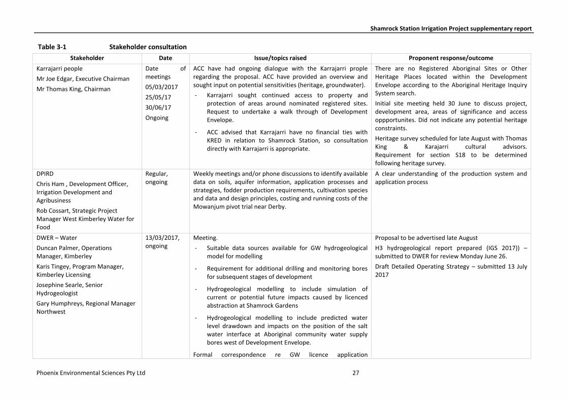
3 STAKEHOLDER ENGAGEMENT ACC has undertaken a program consultation with key stakeholders over the past seven months.
Key stakeholders identified for the Proposal are as follows:
- Karrajarri People regarding native title and heritage
- DWER regarding water licencing and native vegetation clearing permit
- Office of the Environmental Protection Authority (OEPA) within DWER regarding Part IV referral
- DPIRD regarding diversification permit, general advice on proposed agricultural enterprise
- DPLH regarding the diversification permit
- DoEE regarding referral under EPBC Act
- Department of Biodiversity, Conservation and Attractions (DBCA) regarding Bibly surveys
- Shire of Broome regarding local government development approval
- Kimberley Environs regarding interest in potential environmental impacts of the Proposal.
A summary of consultation undertaken to date is provided in Table 3-1.
The Proposal will be publicly advertised following determination on approvals pathway.
Shamrock Station Irrigation Project supplementary report
Phoenix Environmental Sciences Pty Ltd 27
Table 3-1 Stakeholder consultation
Stakeholder Date Issue/topics raised Proponent response/outcome
Karrajarri people
Mr Joe Edgar, Executive Chairman
Mr Thomas King, Chairman
Date of meetings
05/03/2017
25/05/17
30/06/17
Ongoing
ACC have had ongoing dialogue with the Karrajarri prople regarding the proposal. ACC have provided an overview and sought input on potential sensitivities (heritage, groundwater).
- Karrajarri sought continued access to property and protection of areas around nominated registered sites. Request to undertake a walk through of Development Envelope.
- ACC advised that Karrajarri have no financial ties with KRED in relation to Shamrock Station, so consultation directly with Karrajarri is appropriate.
There are no Registered Aboriginal Sites or Other Heritage Places located within the Development Envelope according to the Aboriginal Heritage Inquiry System search.
Initial site meeting held 30 June to discuss project, development area, areas of significance and access oppportunites. Did not indicate any potential heritage constraints.
Heritage survey scheduled for late August with Thomas King & Karajarri cultural advisors. Requirement for section S18 to be determined following heritage survey.
DPIRD
Chris Ham , Development Officer, Irrigation Development and Agribusiness
Rob Cossart, Strategic Project Manager West Kimberley Water for Food
Regular, ongoing
Weekly meetings and/or phone discussions to identify available data on soils, aquifer information, application processes and strategies, fodder production requirements, cultivation species and data and design principles, costing and running costs of the Mowanjum pivot trial near Derby.
A clear understanding of the production system and application process
DWER – Water
Duncan Palmer, Operations Manager, Kimberley
Karis Tingey, Program Manager, Kimberley Licensing
Josephine Searle, Senior Hydrogeologist
Gary Humphreys, Regional Manager Northwest
13/03/2017, ongoing
Meeting.
- Suitable data sources available for GW hydrogeological model for modelling
- Requirement for additional drilling and monitoring bores for subsequent stages of development
- Hydrogeological modelling to include simulation of current or potential future impacts caused by licenced abstraction at Shamrock Gardens
- Hydrogeological modelling to include predicted water level drawdown and impacts on the position of the salt water interface at Aboriginal community water supply bores west of Development Envelope.
Formal correspondence re GW licence application
Proposal to be advertised late August
H3 hydrogeological report prepared (IGS 2017)) – submitted to DWER for review Monday June 26.
Draft Detailed Operating Strategy – submitted 13 July 2017
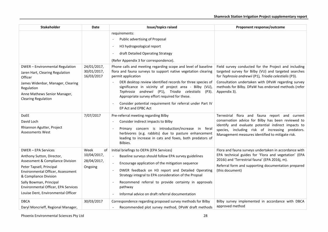
Shamrock Station Irrigation Project supplementary report
Phoenix Environmental Sciences Pty Ltd 28
Stakeholder Date Issue/topics raised Proponent response/outcome
requirements:
- Public advertising of Proposal
- H3 hydrogeological report
- draft Detailed Operating Strategy
(Refer Appendix 3 for correspondence).
DWER – Environmental Regulation
Jaren Hart, Clearing Regulation Officer
James Widenbar, Manager, Clearing Regulation
Anne Mathews Senior Manager, Clearing Regulation
24/01/2017, 30/01/2017, 16/03/2017
Phone calls and meeting regarding scope and level of baseline flora and fauna surveys to support native vegetation clearing permit application
- DER desktop review identified records for three species of significance in vicinity of project area - Bilby (VU), Tephrosia andrewii (P1), Triodia celestialis (P3). Appropriate survey effort required for these.
- Consider potential requirement for referral under Part IV EP Act and EPBC Act
Field survey conducted for the Project and including targeted survey for Bilby (VU) and targeted searches for Tephrosia andrewii (P1), Triodia celestialis (P3).
Consultation undertaken with DPaW regarding survey methods for Bilby. DPaW has endorsed methods (refer Appendix 3).
DoEE
David Loch
Rhiannon Agutter, Project Assessments West
7/07/2017 Pre-referral meeting regarding Bilby
- Consider indirect impacts to Bilby
- Primary concern is introduction/increase in feral herbivores (e.g. rabbits) due to pasture enhancement leading to increase in cats and foxes, both predators of Bilbies.
Terrestrial flora and fauna report and current conservation advice for Bilby has been reviewed to identify and evaluate potential indirect impacts to species, including risk of increasing predators. Management measures identified to mitigate risk.
DWER – EPA Services
Anthony Sutton, Director, Assessment & Compliance Division
Peter Tapsell, Principal Environmental Officer, Assessment & Compliance Division
Sally Bowman, Principal Environmental Officer, EPA Services
Louise Dent, Environmental Officer
Week of 10/04/2017,
28/04/2017,
Ongoing
Initial briefings to OEPA (EPA Services)
- Baseline surveys should follow EPA survey guidelines
- Encourage application of the mitigation sequence
- DWER feedback on H3 report and Detailed Operating Strategy integral to EPA consideration of the Propsal
- Recommend referral to provide certainty in approvals pathway
- Informal advice on draft referral documentation
Flora and fauna surveys undertaken in accordance with EPA technical guides for ‘Flora and vegetation’ (EPA 2016i) and ‘Terrestrial fauna’ (EPA 2016j, m).
Referral form and supporting documentation prepared (this document)
DBCA
Daryl Moncrieff, Regional Manager,
30/03/2017 Correspondence regarding proposed survey methods for Bilby
- Recommended plot survey method, DPaW draft methods
Bilby survey implemented in accordance with DBCA approved method
Shamrock Station Irrigation Project supplementary report
Phoenix Environmental Sciences Pty Ltd 29
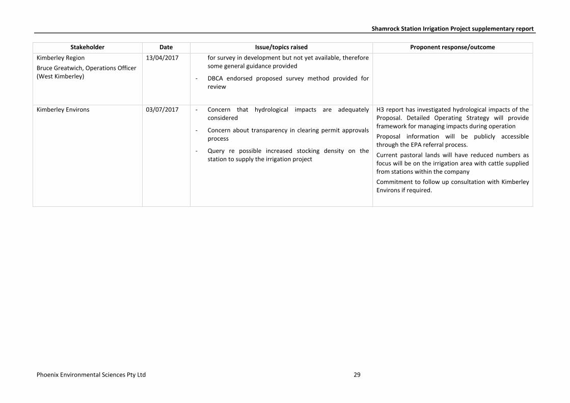
Stakeholder Date Issue/topics raised Proponent response/outcome
Kimberley Region
Bruce Greatwich, Operations Officer (West Kimberley)
13/04/2017 for survey in development but not yet available, therefore some general guidance provided
- DBCA endorsed proposed survey method provided for review
Kimberley Environs 03/07/2017 - Concern that hydrological impacts are adequately considered
- Concern about transparency in clearing permit approvals process
- Query re possible increased stocking density on the station to supply the irrigation project
H3 report has investigated hydrological impacts of the Proposal. Detailed Operating Strategy will provide framework for managing impacts during operation
Proposal information will be publicly accessible through the EPA referral process.
Current pastoral lands will have reduced numbers as focus will be on the irrigation area with cattle supplied from stations within the company
Commitment to follow up consultation with Kimberley Environs if required.
Shamrock Station Irrigation Project supplementary report
Phoenix Environmental Sciences Pty Ltd 30
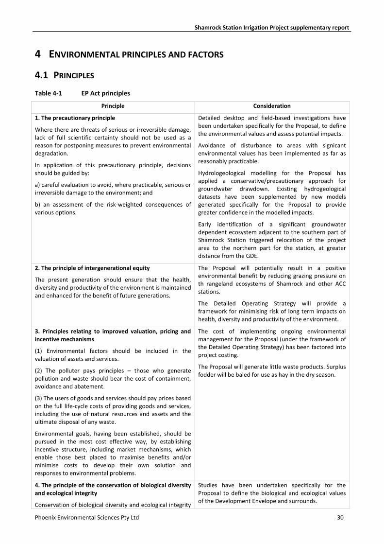
4 ENVIRONMENTAL PRINCIPLES AND FACTORS
4.1 PRINCIPLES
Table 4-1 EP Act principles
Principle Consideration
1. The precautionary principle
Where there are threats of serious or irreversible damage, lack of full scientific certainty should not be used as a reason for postponing measures to prevent environmental degradation.
In application of this precautionary principle, decisions should be guided by:
a) careful evaluation to avoid, where practicable, serious or irreversible damage to the environment; and
b) an assessment of the risk-weighted consequences of various options.
Detailed desktop and field-based investigations have been undertaken specifically for the Proposal, to define the environmental values and assess potential impacts.
Avoidance of disturbance to areas with signicant environmental values has been implemented as far as reasonably practicable.
Hydrologeological modelling for the Proposal has applied a conservative/precautionary approach for groundwater drawdown. Existing hydrogeological datasets have been supplemented by new models generated specifically for the Proposal to provide greater confidence in the modelled impacts.
Early identification of a significant groundwater dependent ecosystem adjacent to the southern part of Shamrock Station triggered relocation of the project area to the northern part for the station, at greater distance from the GDE.
2. The principle of intergenerational equity
The present generation should ensure that the health, diversity and productivity of the environment is maintained and enhanced for the benefit of future generations.
The Proposal will potentially result in a positive environmental benefit by reducing grazing pressure on th rangeland ecosystems of Shamrock and other ACC stations.
The Detailed Operating Strategy will provide a framework for minimising risk of long term impacts on health, diversity and productivity of the environment.
3. Principles relating to improved valuation, pricing and incentive mechanisms
(1) Environmental factors should be included in the valuation of assets and services.
(2) The polluter pays principles – those who generate pollution and waste should bear the cost of containment, avoidance and abatement.
(3) The users of goods and services should pay prices based on the full life-cycle costs of providing goods and services, including the use of natural resources and assets and the ultimate disposal of any waste.
Environmental goals, having been established, should be pursued in the most cost effective way, by establishing incentive structure, including market mechanisms, which enable those best placed to maximise benefits and/or minimise costs to develop their own solution and responses to environmental problems.
The cost of implementing ongoing environmental management for the Proposal (under the framework of the Detailed Operating Strategy) has been factored into project costing.
The Proposal will generate little waste products. Surplus fodder will be baled for use as hay in the dry season.
4. The principle of the conservation of biological diversity and ecological integrity
Conservation of biological diversity and ecological integrity
Studies have been undertaken specifically for the Proposal to define the biological and ecological values of the Development Envelope and surrounds.
Shamrock Station Irrigation Project supplementary report
Phoenix Environmental Sciences Pty Ltd 31
Principle Consideration
should be a fundamental consideration. Minimising impacts to the identified biological and ecological values has been a key factor in Proposal design, for both the groundwater abstraction regime and site layout.
5. The principle of waste minimisation
All reasonable and practicable measures should be taken to minimise the generation of waste and its discharge into the environment.
ACC will apply the waste hierarchy to project operations.
4.2 FLORA AND VEGETATION
4.2.1 EPA objective
The EPA objective for Flora and Vegetation is to protect flora and vegetation so that biological diversity and ecological integrity are maintained. In the context of this objective, ecological integrity is the composition, structure, function and processes of ecosystems, and the natural range of variation of these elements.
4.2.2 Policy and guidance
The following EPA guidelines have been in the assessment of Flora and Vegetation with respect to the EPA objective:
• Environmental Factor Guideline: Flora and vegetation (EPA 2016a)
• Technical Guidance: Flora and vegetation surveys for environmental impact assessment (EPA 2016i).
4.2.3 Receiving environment
A single season detailed flora and vegetation survey was undertaken within and in the vicinity of the Development Envelope in April–May 2017 (Phoenix 2017). The study area for the survey was approximately 3,500 ha and encompassed the 2,560 ha Development Envelope (Figure 2-9). Field survey methods included systematic sampling of flora and vegetation, assessment and mapping of vegetation type and condition, and targeted searches for significant flora. A total of 25 50x50 m quadrats and seven relevés were sampled for flora and vegetation and targeted searches were conducted for significant flora.
The survey was implemented in accordance with EPA guidance for a detailed survey (EPA 2016i) with regard to appropriate expertise of the lead botanist in the bioregion, desktop study completed prior to field work, sampling techniques (quadrats, relevés and targeted searches), vegetation condition rating, statistical analysis and vegetation unit classification. Survey intensity (minimium of three replicates per vegetation unit) met the guidelines as far as possible; several vegetation types had limited representation in the study area and therefore were not able to be sampled with three quadrats. Survey timing was partially compliant with the guidance which recommends the wet season (January – March) as the primary survey and the post wet season for a supplementary survey, if required. The survey was conducted 27 April–6 May and conditions were considered optimal due to above average annual rainfall in the months leading up to the survey, with only 2.6% of the taxa unable to be identified due to insufficient reproductive characters.
Shamrock Station Irrigation Project supplementary report
Phoenix Environmental Sciences Pty Ltd 32
4.2.3.1 Vegetation
Six vegetation types were recorded in the study area of which five are present in the Development Envelope (Figure 2-9). The majority of the Development Envelope (91%) is represented by a woodland of Corymbia hamersleyana and C. zygophylla over tall shrubland dominated by Acacia eriopoda over tussock grassland dominated by Triodia schinzii (Table 4-2). The remainder was mapped as four shrublands, all dominated by Acacia eriopoda with mixed species mid to low shrublands over mixed tussock grasslands. One shrubland (Type 04, CzAeAh) comprised mainly ephemeral shrubs recolonising previously cleared areas.
The condition of vegetation across the study area ranged from Excellent to Completely Degraded according to the condition scale of the Trudgen (1988 in EPA 2016i). The majority of vegetation was mapped as Excellent with regrowth of vegetation in previously cleared areas (including historic tracks) rated as Very Good (Figure 2-10). With the Development Envelope, 2,492 ha is mapped as Excellent condition, 56 ha as Very Good condition and 11 ha as Degraded.
Regional scale vegetation mapping by Shepherd et al. (2002; after Beard) defined one vegetation association in the Development Envelope; Association 699 Acacia thicket with scattered low trees over spinifex Acacia eriopoda, Corymbia dichromophloia, Triodia pungens, T. bitextura. The vegetation types defined in the Development Envelope by the flora and vegetation survey (Phoenix 2017) are generally representative of this broad Pindan shrubland vegetation association which is extensively represented in the correspondingly named Pindanland subregion (4,928,779 ha) and has over 99% remaining according to Government of Western Australia (2016) (Figure 2-11).
The desktop review conducted for the survey determined that no threatened ecological communities (TECs) listed under the EPBC Act or the WC Act, priority ecological communities (PECs) listed by DBCA, or Environmentally Sensitive Areas are present within the study area. Six vegetation-related PECs were identified within a 40 km radius of the study area (Figure 2-11):
• Eighty Mile Land System (P3) 12 km west. Beach foredunes, longitudinal coastal dunes and sandy plains with tussock grasslands and spinifex grasslands.
• Gourdon Land System (P3) 9 km west. Sandplain and undulating lateritic country with steep coastal gullies supporting spinifex grasslands with scattered trees.
• Parda Land System (P3) 25 km east. Conical hills, stony ring plains, alluvial plains and shallow valleys supporting spinifex grasslands with sparse shrubs and trees.
• Roebuck Land System (P3) 20 km west and within Injudinah Swamp. Paleo-tidal coastal plains and tidal flats with saline soil supporting salt-water couch grasslands, samphire low shrublands, melaleuca.
• Kimberley Vegetation Association 37 (P3) 12 km southwest, part of Injudinah Swamp. As defined by John Beard’s vegetation mapping for the Kimberley (Beard 1979). Shrublands; teatree thicket.
• Kimberley Vegetation Association 73 (P3) 17 km north. As defined by John Beard’s vegetation mapping for the Kimberley (Beard 1979). Grasslands, tall bunch grass savanna, mitchell & blue grass. Unlikely to be relevant to study area
None of the PECs resemble vegetation of the study area.
4.2.3.2 Flora
A total of 114 flora species and subspecies representing 32 families and 78 genera were recorded during the field survey. This included 88 perennial species and 26 annual or short-lived species. No introduced flora species were recorded.
The desktop review conducted for the survey did not identify any known records of Threatened or Priority Flora in the study area; however, database records of three Priority Flora species were identified within a 40 km radius of the study area: Tephrosia andrewii (Priority 1), Polymeria distigma (Priority 3) and Triodia
Shamrock Station Irrigation Project supplementary report
Phoenix Environmental Sciences Pty Ltd 33
caelestialis (Priority 3). Two of these, Tephrosia andrewii and Triodia caelestialis, and one other Priority species, Polymeria sp. Broome (Priority 1), were recorded in the survey.
No EPBC Act or WC Act listed Threatened flora were recorded during the survey.
Tephrosia andrewii (Priority 1)
Tephrosia andrewii is endemic to an area between Broome and Port Headland. The species grows in pindan country, in shrubland on sandy soils (Cowie 2004). It is known from only a few collections and is not known to occur on any reserve. Florabase (DPaW 2017a) lists three locations for T. andrewii which span an approximate distance of 140 km along Great Northern Highway. Notably, all three locations are situated in close proximity to the road verge of the highway.
Habitat descriptions of the three locations are (DBCA 2017a):
• red sand on a low rise in Acacia ?neurocarpa, Erythrophleum, Grevillea pyramidalis low woodland with Chrysopogon and Triodia
• road verge on a hill side in brown sand in a tall shrubland/Pindan
• road verge on a plain in brown sand in low shrubland, with Triodia sp. in Pindan.
There is no record of plant numbers at the southern-most recorded population of the species (DBCA 2017a) approximately 120 km to the south of the Development Envelope. Plant numbers “in excess of 50 plants” were recorded at the population located approximately 8 km from the northern end of the Development Envelope, and the plants were described as “uncommon” for the population recorded approximately 15 km from the northern end of the Development Envelope.
Over 370 plants were recorded in the study area during the survey from 18 locations ranging from 1 to >100 individuals (Figure 2-9). Two large populations of 100+ plants were recorded in the study area, one in the very southeast corner and the other on the northern boundary (Figure 2-9). The species was recorded in the dominant woodland vegetation type and in low Corymbia hamersleyana and C. zygophylla woodland over low sparse Indigofera monophylla, Tephrosia andrewii and T. sp. D Kimberley Flora shrubland over low open Aristida holathera, Chrysopogon pallidus and Triodia schinzii tussock grassland.
The Tephrosia andrewii records within the study area represent new populations for the species. Although the lack of population data from the previous records precludes accurate determination of the proportion of T. andrewii plants present in the study area, the two larger populations (i.e. in excess of 100 individuals) may be considered significant as they would appear to represent the largest recorded populations.
All known populations, those recorded in the present survey and those recorded previously occur in vegetation that may be broadly described as Pindan. This vegetation is prevalent within the correspondingly named Pindanland subregion and occurs over the broader landscape immediately surrounding the current study area. Given the extensive representation of suitable habitat for this species in the broader landscape it is considered highly likely that further populations occur outside of the current recorded distribution of the species. The results of the current survey indicate that large populations of the species may remain undetected due to limited surveys in the Pindanland subregion.
Polymeria sp. Broome
Polymeria sp. Broome is a prostrate herb 10 cm high x 30 cm wide, trailing herb with greyish green leaves and mauve flowers. According to DBCA (2017a), the species is confined to the Pindanland subregion and is known from five records with variable habitat including:
• poorly defined drainage line on a plain in pale orange pindan sand in Acacia eriopoda, A. monticola, Grevillea pyramidalis and Hakea macrocarpa tall shrubland over Dodonaea hispidula var. arida open shrubland and Eucalyptus miniata tall open woodland over Acacia eriopoda and A. monticola tall open shrubland
• Acacia eriopoda shrubland over low Gyrostemon tepperi low open shrubland over Eragrostis aff. eriopoda, Aristida holathera var. holathera and A. hygrometrica open tussock grassland
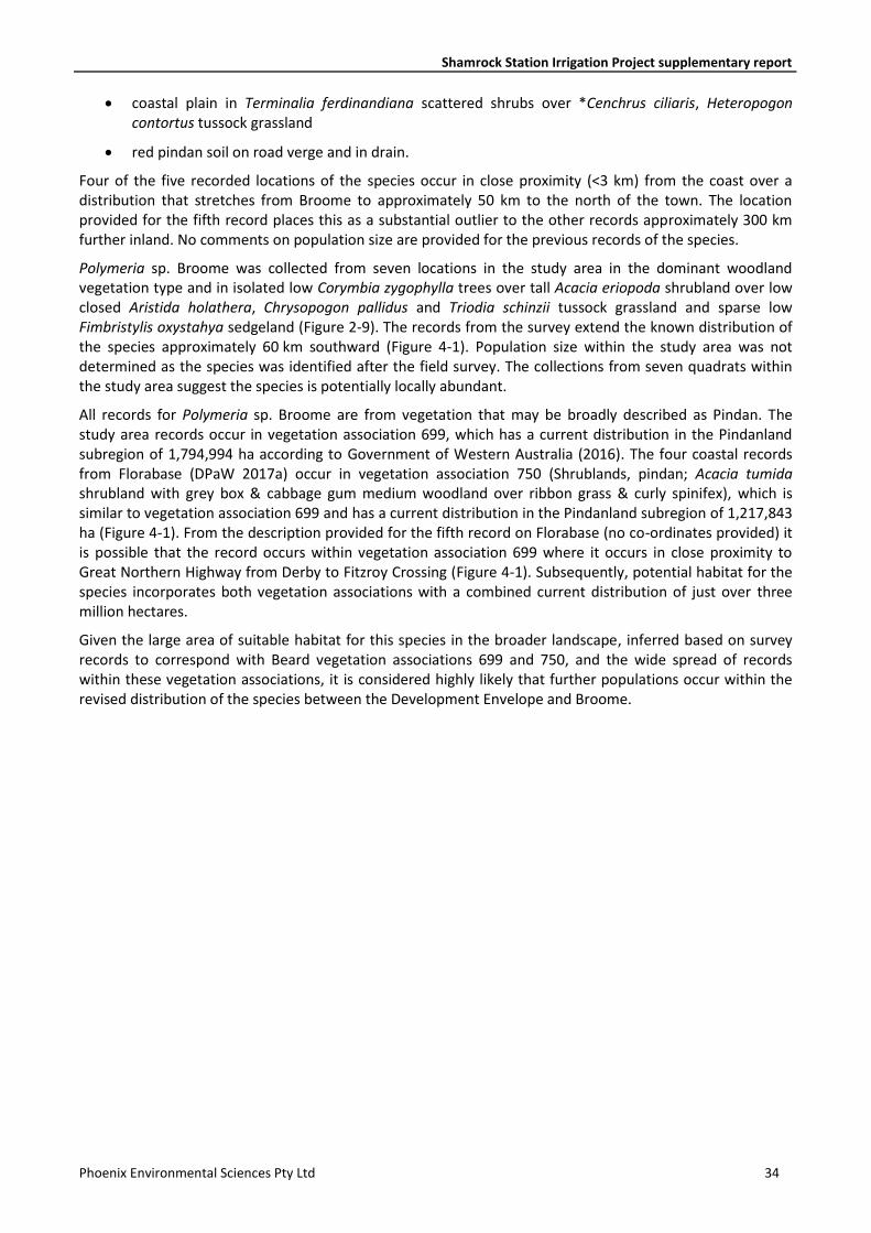
Shamrock Station Irrigation Project supplementary report
Phoenix Environmental Sciences Pty Ltd 34
• coastal plain in Terminalia ferdinandiana scattered shrubs over *Cenchrus ciliaris, Heteropogon contortus tussock grassland
• red pindan soil on road verge and in drain.
Four of the five recorded locations of the species occur in close proximity (<3 km) from the coast over a distribution that stretches from Broome to approximately 50 km to the north of the town. The location provided for the fifth record places this as a substantial outlier to the other records approximately 300 km further inland. No comments on population size are provided for the previous records of the species.
Polymeria sp. Broome was collected from seven locations in the study area in the dominant woodland vegetation type and in isolated low Corymbia zygophylla trees over tall Acacia eriopoda shrubland over low closed Aristida holathera, Chrysopogon pallidus and Triodia schinzii tussock grassland and sparse low Fimbristylis oxystahya sedgeland (Figure 2-9). The records from the survey extend the known distribution of the species approximately 60 km southward (Figure 4-1). Population size within the study area was not determined as the species was identified after the field survey. The collections from seven quadrats within the study area suggest the species is potentially locally abundant.
All records for Polymeria sp. Broome are from vegetation that may be broadly described as Pindan. The study area records occur in vegetation association 699, which has a current distribution in the Pindanland subregion of 1,794,994 ha according to Government of Western Australia (2016). The four coastal records from Florabase (DPaW 2017a) occur in vegetation association 750 (Shrublands, pindan; Acacia tumida shrubland with grey box & cabbage gum medium woodland over ribbon grass & curly spinifex), which is similar to vegetation association 699 and has a current distribution in the Pindanland subregion of 1,217,843 ha (Figure 4-1). From the description provided for the fifth record on Florabase (no co-ordinates provided) it is possible that the record occurs within vegetation association 699 where it occurs in close proximity to Great Northern Highway from Derby to Fitzroy Crossing (Figure 4-1). Subsequently, potential habitat for the species incorporates both vegetation associations with a combined current distribution of just over three million hectares.
Given the large area of suitable habitat for this species in the broader landscape, inferred based on survey records to correspond with Beard vegetation associations 699 and 750, and the wide spread of records within these vegetation associations, it is considered highly likely that further populations occur within the revised distribution of the species between the Development Envelope and Broome.
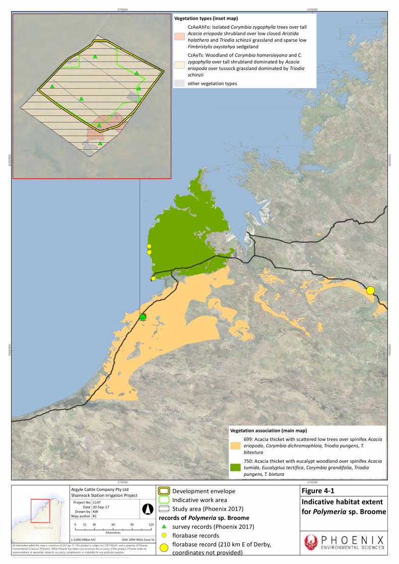
Wes ter nAus t r al ia
All information within this map is current as of 20-Sep-17. This product is subject to COPYRIGHT and is property of PhoenixEnvironmental Sciences (Phoenix). While Phoenix has taken care to ensure the accuracy of this product, Phoenix make norepresentations or warranties about its accuracy, completeness or suitability for any particular purpose.
!(
!(
!(
!(!(
#*#*#*#*#*#*#*
370000
370000
670000
670000
7900
000
7900
000
8200
000
8200
000
P:\GIS\Projects\ShamrockStationIrrigationProject\1163-SIP-AC-APP\Mapping\MapDocuments\Figures\EP Act\new\1163-PolymeriaBroome2.mxd
Development envelopeIndicative work areaStudy area (Phoenix 2017)
records of Polymeria sp. Broome#* survey records (Phoenix 2017)!( florabase records!(
florabase record (210 km E of Derby,coordinates not provided)
0 30 60 90 12015Kilometres
1:3,000,000
Argyle Cattle Company Pty LtdShamrock Station Irrigation Project
Map authorDrawn by
GDA 1994 MGA Zone 51
°
(at A4)
20-Sep-17DateProject No 1147
KWKC
Indicative habitat extentfor Polymeria sp. Broome
Figure 4-1
Vegetation association (main map)699: Acacia thicket with scattered low trees over spinifex Acaciaeriopoda, Corymbia dichromophloia, Triodia pungens, T.bitextura750: Acacia thicket with eucalypt woodland over spinifex Acaciatumida, Eucalyptus tectifica, Corymbia grandifolia, Triodiapungens, T. bixtura
#*
#*
#*
#*
#*
#*
#*
Vegetation types (inset map)CzAeAhFo: Isolated Corymbia zygophylla trees over tallAcacia eriopoda shrubland over low closed Aristidaholathera and Triodia schinzii grassland and sparse lowFimbristylis oxystahya sedgelandCzAeTs: Woodland of Corymbia hamersleyana and C.zygophylla over tall shrubland dominated by Acaciaeriopoda over tussock grassland dominated by Triodiaschinziiother vegetation types

Shamrock Station Irrigation Project supplementary report
Phoenix Environmental Sciences Pty Ltd 36
Triodia caelestialis
Triodia caelestialis is a caespitose, non-resinous, non-stoloniferous perennial forming compact, non-branching tussocks 40 cm tall x 60 cm wide (Armstrong 2008). According to Florabase (DPaW 2017a), in addition to records from the Pindanland subregion and Fitzroy Trough subregion of the Dampierland bioregion, it is also known from the Pentecost subregion of the Central Kimberley bioregion and Mitchell subregion of the Northern Kimberley bioregion. This distribution covers an area of thousands of square kilometres and the species is recorded in a variety of habitats including:
• red sandplain with pindan shrubland
• brown orange sand plain in Corymbia greeniana low woodland with Bauhinia cunninghamii, Triodia acutispicula, Sorghum plumosum and Chrysopogon pallidus
• brown sand-silt on low plain in woodland with Chrysopogon fallax, Sorghum stipoideum, Eriachne obtusa and Grevillea striata
• gentle mid-slope in red sand with Michrostachys chamaelea, Acacia tumida var. tumida, Chrysopogon pallidus and Corymbia greeniana
• brown sandy loam on flat lower slope with Acacia tumida var. pilbarensis, Santalum lanceolatum, Acacia colei var. colei, Corymbia bella and Enneapogon polyphyllus
• open woodland savannah in skeletal soil on mountainous low ridge
• flat pindan plain with ironstone gravel with Acacia holosericea and Sorghum savannah
• sandstone habitat (Armstrong 2008).
A population size of 40 plants is provided for one previous record; no other population numbers are provided for the remaining 23 records.
Triodia caelestialis was recorded in the dominant woodland vegetation type of the study area from 16 locations, with numbers ranging from 1 to 25 plants, 62 plants in total (Figure 2-9).
4.2.4 Potential impacts
Potential impacts to flora and vegetation by the Proposal include:
• direct clearing of remnant vegetation up to 650 ha and vegetation degradation from intensive grazing in vegetation buffers up to 550 ha
• loss of habitat for Priority Flora
• groundwater drawdown potential to affect groundwater dependent vegetation
• introduction and spread of cultivation species into remnant vegetation.
4.2.5 Assessment of impacts
4.2.5.1 Vegetation clearing and degradation
As the project layout has not yet been finalised it is not possible to calculate the total area of clearing, and clearing extent within each vegetation type. The indicative work area is represented by 1,841 ha of remnant native vegetation, all mapped as Excellent condition vegetation and 43 ha of regrowth vegetation including overgrown access tracks, mapped as Very Good condition vegetation (Figure 2-10).
Based on maximum footprint requirements for the Proposal, total vegetation clearing requirements will be no more than 650 ha and total extent of vegetation buffers will be no more than 550 ha; this equates to a maximium disturbance of 1,200 ha. On this basis, under a worst case scenario, up to 1,200 ha of remnant vegetation in Excellent condition will be disturbed; however, it is intended to use some of the existing access
Shamrock Station Irrigation Project supplementary report
Phoenix Environmental Sciences Pty Ltd 37
tracks, therefore total clearing of Excellent condition vegetation will be lower. Representative photographs of vegetation to be disturbed are provided in Figure 2-8.
At the local scale (flora and vegetation survey study area extent), a maximum of 57.7% (1,804 ha) of the dominant woodland vegetation type (CzAeTs) will be impacted by the Proposal based on extent in the indicative work area relative to total mapped in the study area (Table 4-2). For the other vegetation types, less than 20% of the mapped extent in the flora and vegetation survey study area will be impacted by the Proposal (Table 4-2), excluding type 4 (CzAeAh) which is regrowth vegetation.
At the regional scale, the vegetation types in the Development Envelope are typically representative of the broad vegetation association 699 Acacia thicket with scattered low trees over spinifex Acacia eriopoda, Corymbia dichromophloia, Triodia pungens, T. bitextura (Shepherd et al. 2002; after Beard). This vegetation association covers nearly 5 mio ha in the Pindanland subregion and has over 99% remaining (Government of Western Australia 2016). Based on this estimate, disturbance to 1,200 ha of vegetation in the Development Envelope represents loss of 0.014% of vegetation association 699 (Table 4-2), which represents a negligible reduction in extent of this association.
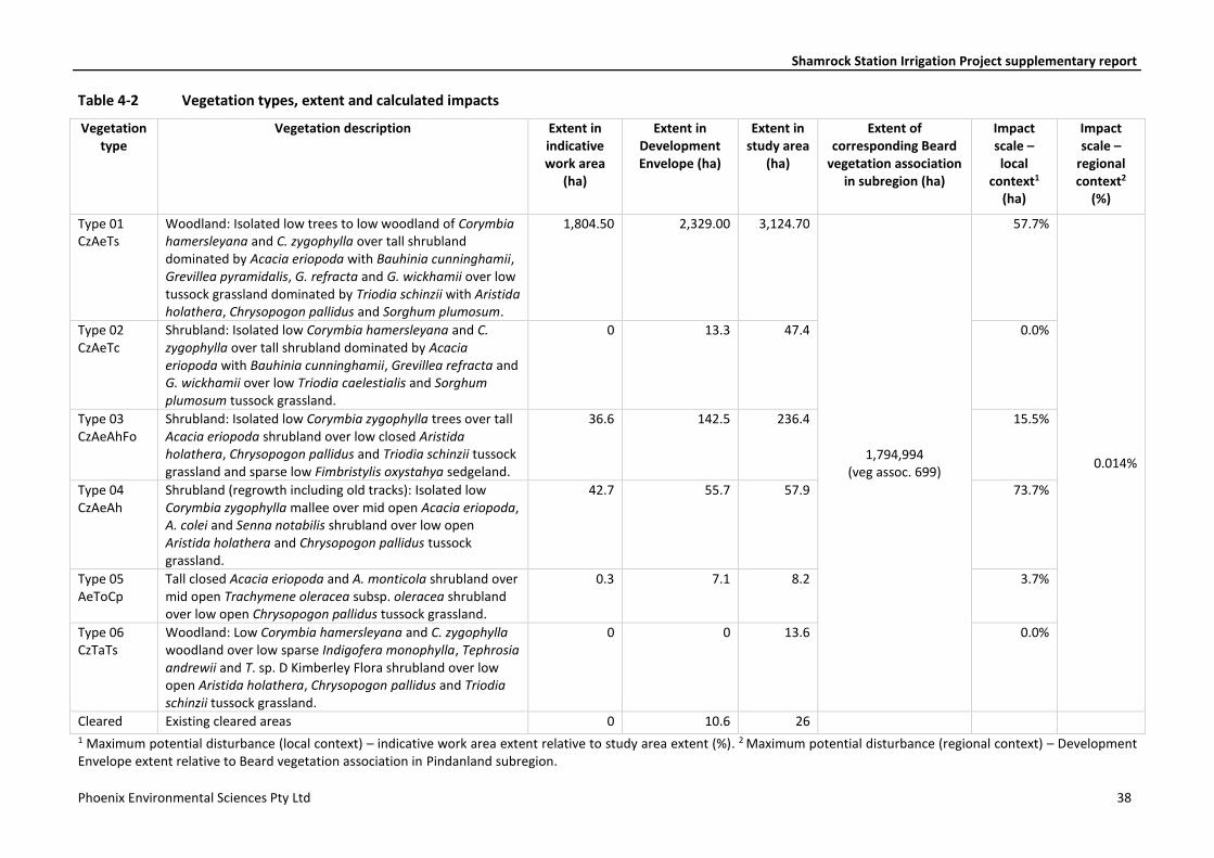
Shamrock Station Irrigation Project supplementary report
Phoenix Environmental Sciences Pty Ltd 38
Table 4-2 Vegetation types, extent and calculated impacts
Vegetation type
Vegetation description Extent in indicative work area
(ha)
Extent in Development Envelope (ha)
Extent in study area
(ha)
Extent of corresponding Beard
vegetation association in subregion (ha)
Impact scale – local
context1 (ha)
Impact scale –
regional context2
(%)
Type 01 CzAeTs
Woodland: Isolated low trees to low woodland of Corymbia hamersleyana and C. zygophylla over tall shrubland dominated by Acacia eriopoda with Bauhinia cunninghamii, Grevillea pyramidalis, G. refracta and G. wickhamii over low tussock grassland dominated by Triodia schinzii with Aristida holathera, Chrysopogon pallidus and Sorghum plumosum.
1,804.50 2,329.00 3,124.70
1,794,994 (veg assoc. 699)
57.7%
0.014%
Type 02 CzAeTc
Shrubland: Isolated low Corymbia hamersleyana and C. zygophylla over tall shrubland dominated by Acacia eriopoda with Bauhinia cunninghamii, Grevillea refracta and G. wickhamii over low Triodia caelestialis and Sorghum plumosum tussock grassland.
0 13.3 47.4 0.0%
Type 03 CzAeAhFo
Shrubland: Isolated low Corymbia zygophylla trees over tall Acacia eriopoda shrubland over low closed Aristida holathera, Chrysopogon pallidus and Triodia schinzii tussock grassland and sparse low Fimbristylis oxystahya sedgeland.
36.6 142.5 236.4 15.5%
Type 04 CzAeAh
Shrubland (regrowth including old tracks): Isolated low Corymbia zygophylla mallee over mid open Acacia eriopoda, A. colei and Senna notabilis shrubland over low open Aristida holathera and Chrysopogon pallidus tussock grassland.
42.7 55.7 57.9 73.7%
Type 05 AeToCp
Tall closed Acacia eriopoda and A. monticola shrubland over mid open Trachymene oleracea subsp. oleracea shrubland over low open Chrysopogon pallidus tussock grassland.
0.3 7.1 8.2 3.7%
Type 06 CzTaTs
Woodland: Low Corymbia hamersleyana and C. zygophylla woodland over low sparse Indigofera monophylla, Tephrosia andrewii and T. sp. D Kimberley Flora shrubland over low open Aristida holathera, Chrysopogon pallidus and Triodia schinzii tussock grassland.
0 0 13.6 0.0%
Cleared Existing cleared areas 0 10.6 26 1 Maximum potential disturbance (local context) – indicative work area extent relative to study area extent (%). 2 Maximum potential disturbance (regional context) – Development Envelope extent relative to Beard vegetation association in Pindanland subregion.
Shamrock Station Irrigation Project supplementary report
Phoenix Environmental Sciences Pty Ltd 39
4.2.5.2 Loss of habitat for Priority Flora
Tephrosia andrewii
Suitable habitat for Tephrosia andrewii is present within the indicative work area and may be impacted by clearing or vegetation degradation in the vegetation buffers. No T. andrewii plants will be directly impacted. Sixteen records totalling 361 plants are outside the Development Envelope (Figure 2-9). Two records totalling 10 plants are within the Development Envelope but outside the indicative work area (Figure 2-9).
Given the extensive representation of suitable habitat for this species in the broader landscape it is considered highly likely that further populations occur outside of the current recorded distribution of the species. As no plants will be directly impacted and habitat is extensive outside the Development Envelope, the Proposal is highly unlikely to inhibit the continued existence of Tephrosia andrewii in the local area.
Polymeria sp. Broome
A population count was not possible for this species as it was identified after the field survey and regional records do not provide population data.
Six of the seven recorded locations Polymeria sp. Broome are within the Development Envelope. Three of these are outside the indicative work area and will not be directly impacted by the Proposal. The remaining three records are inside the indicative work area and may be directly impacted by clearing for the Proposal.
It is considered highly likely that further populations occur in the immediate vicinity of the Development Envelope and more broadly within the revised distribution of the species between the Development Envelope and Broome. Based on indicative habitat mapping for the species (section 4.2.3.2), a maximum of 0.06% (1,804 ha) of the estimated 3,012,837 ha of potential habitat (Figure 4-1) will be removed for the Proposal.
Clearing for the Proposal will reduce the local adundance of Polymeria sp. Broome, however, the Proposal is unlikely to inhibit the continued existence of Tephrosia andrewii in the local area as a habitat corridor on the eastern side of the Development Envelope will be retained which contains more than half of the known locations recorded during the flora and vegetation survey. A targeted survey will be undertaken for the species to map populations within and outside the Development Envelope.
Triodia caelestialis
Two records of Triodia caelestialis totalling two plants are outside the Development Envelope and will not be impacted by the Proposal. Four records totalling eight plants are within the Development Envelope but outside the indicative work area and will also not be directly impacted by clearing for the Proposal (Figure 2-9).
Ten records comprising 58 plants are within the indicative work area and may be directly impacted by clearing for the Proposal (Figure 2-9). Of these, the only large population recorded (25 plants) will be avoided if possible, although there are several factors driving final site selection.
Given the broad distribution of the species across a variety of habitats, and the avoidance of clearing of some of the records from the study area, it is considered unlikely that disturbance to populations in the study area would represent a significant impact on the species.
4.2.5.3 Groundwater drawdown
No groundwater dependent vegetation communities are present within the Development Envelope.
Potential impacts of groundwater drawdown on vegetation associated with Injudinah Swamp are covered in section 4.4.
Shamrock Station Irrigation Project supplementary report
Phoenix Environmental Sciences Pty Ltd 40
4.2.5.4 Introduction/spread of cultivation species
The proposed grazing grass to be utilised for the Project, Rhodes grass (Chloris gayana) is a non-native fodder species. Possible supplementary crops of forage sorghum (Sorghum spp.) and oats (Avena sativa) may be planted in some pivots in the cooler months.
Both oats and forage sorghum are considered to be of low risk to the environment and suitable for cultivation under most circumstances according to the Non indigenous plant species lists for Western Australia’s rangelands (DAFWA et al. 2012).
Rhodes grass is not listed as either a permitted on prohibited rangeland cultivation species (DAFWA et al. 2012). The species is a permitted plant in Western Australia (DAFWA 2016) and has a Low risk rating according to the Environmental Weed Strategy (DEC 1999). Previous studies on the invasiveness of Rhodes grass at Kilto Station, located approximately 115 km north of Shamrock Station, indicated the species has low invasive properties, only establishing and persisting beyond cultivation in highly disturbed areas with high soil moisture, and under a ‘no active weed management’ regime (Hurter & Naaykens 2012; Rio Tinto 2013). Isolated occurrences of non-vigorous plants were observed in intact vegetation following wet season conditions, but were absent in the same environments during the late dry season, indicating the species may not persist in undisturbed soil and sustained elevated soil moisture conditions (Rio Tinto 2013). Occurrences were limited to within 300 m of pivot cells or associated irrigated agriculture infrastructure and there was no evidence of individuals successfully spreading vegetatively to colonise or smother native vegetation. The study concluded that factors such as competition with native species, poor soil fertility, and low/variable soil moisture potentially act as a major constraint on the ability of Rhodes grass to persist and spread in intact native vegetation (Rio Tinto 2013).
The native vegetation being retained within the Development Envelope for the Proposal is currently subject to low level of disturbance, with the condition of native vegetation rated as almost entirely excellent condition (Phoenix 2017). On the basis of the findings from the Rio Tinto (2013) study, it is reasonable to assume that the risk of significant spread of Rhodes grass into the remaining vegetation is low, provided this vegetation/habitat remains undisturbed.
4.2.6 Mitigation
The Development Envelope has been revised to avoid Priority Flora populations as far as practicable. This includes all large populations of Tephrosia andrewii. A further avoidance measure has been implemented by modifying the indicative work area to protect additional populations. A vegetation corridor will be retained on the eastern boundary to maintain habitat connectivity for all three Priority Flora species.
Management measures for Flora and Vegetation are identified in the draft Environmental Management Plan (EMP) provisions table to minimise impacts to flora and vegetation (Appendix 4). These will include but not be limited to:
• demarcation of Priority Flora populations to be protected
• drainage control to avoid erosion/degradation risk to habitat for Priority Flora
• monitoring and control of cultivation species
• buffer zones between non native pastures and native vegetation.
As the Proposal will meet the EPA objective for Flora and Vegetation, no offset is required. As it is intended to establish and maintain the irrigation pivots indefinitely, a vegetation rehabilitation plan has not been prepared.
Shamrock Station Irrigation Project supplementary report
Phoenix Environmental Sciences Pty Ltd 41
4.2.7 Predicted outcome
The Proposal is not expected to affect the conservation status of any significant flora species or ecological communities, or have a significant effect on the representation of species or habitats at a local or regional level.
4.3 TERRESTRIAL FAUNA
4.3.1 EPA objective
The EPA’s objective for the factor Terrestrial Fauna is to protect terrestrial fauna so that biological diversity and ecological integrity are maintained. Ecological integrity is the composition, structure, function and processes of ecosystems, and the natural range of variation of these elements.
4.3.2 Policy and guidance
The following EPA guidelines have been considered in the assessment of terrestrial fauna with respect to the EPA objective:
• EPA Environmental Factor Guideline: Terrestrial fauna (EPA 2016g)
• EPA Technical Guidance: Terrestrial fauna surveys (EPA 2016m)
• EPA Technical Guidance: Sampling methods for terrestrial vertebrate fauna (EPA 2016j)
• EPA Technical Guidance: Sampling of short range endemic invertebrate fauna (EPA 2016k).
4.3.3 Receiving environment
A Level 1 terrestrial fauna assessment and targeted assessment for Bilby was conducted concurrently with the flora and vegetation survey in April–May 2017 to assess terrestrial fauna habitat and the presence of conservation significant species (Phoenix 2017). The study area for the survey was 3,532 ha and encompassed the 2,560 ha Development Envelope (Figure 2-12).
Field survey methods included terrestrial fauna habitat assessment and mapping, active searches for direct and secondary evidence of fauna species, avifauna censusing and acoustic call recordings for bats and Night Parrot (Pezoporus occidentalis). Targeted Bilby plot surveys were undertaken to search for evidence of the species in the study area using standardised 2 ha plots adopted from Southgate et al. (2005) and Southgate and Moseby (2008).
The terrestrial fauna survey was implemented in accordance with EPA guidance (EPA 2016j, m) in regard to appropriate expertise of the zoologist, survey level and sampling methods as appropriate to the study area. The survey scope was defined following an initial desktop review of potential habitat and significant species that may be present in the study area which identified Bilby as the main significant species of potential relevance. This took into account the guidance in Tables 2 and 3 of EPA (EPA 2016m) for determination of survey level required, based on bioregion and characteristics defining the scale and nature of impacts.
Consultation was undertaken with DBCA Kimberley Region (Daryl Moncreiff, Regional Manager and Bruce Greatwich, Operations Officer West Kimberley) regarding proposed sampling methods for Bilby prior to the field survey. These were endorsed through correspondence from Margaret Byrne, Director Science and Conservation (13 April 2017). Accoustic recordings for Night Parrot were undertaken following review of the current guidance for the species (DPaW 2017b) for relevance to the study area.
Survey timing was considered largely compliant with the guidance (EPA 2016j), which recommends the wet season (December – March, or as soon as practical after) as the period of highest vertebrate activity; while the survey was conducted in April conditions were considered favourable for sampling, with 50 species recorded in a Level 1 survey.
Shamrock Station Irrigation Project supplementary report
Phoenix Environmental Sciences Pty Ltd 42
A single terrestrial fauna habitat, ‘Tall shrubland thicket with scattered eucalypt trees’, was defined in 99.3% of the study area (0.7% was cleared areas) composed of six different vegetation types (Figure 2-12) (Phoenix 2017). This habitat is widely represented in the Pindanland subregion.
Part of this habitat has been considered suitable for the Greater Bilby (Macrotis lagotis), which is listed as Vulnerable under the EPBC Act and WC Act, in particular along the eastern edge and northern part of the study area where understory was less dense than the remainder of shrubland and some open areas were present (Figure 2-12). The denser areas of shrubland thicket elsewhere in the study area were mostly not considered optimal for Greater Bilby movement and occurrence.
The Rainbow Bee-eater (Merops ornatus), which is listed as Migratory under the WC Act, was recorded on several occasions. This is a common and widely distributed bird and the habitat of the study area is not considered critical habitat for the species. Breeding of Rainbow Bee-eaters would be most likely along the eastern edge of the study area that provides open areas for these birds to construct burrows.
The habitat within the study area may also host the Princess Parrot (Polytelis alexandrae; Vulnerable under the EPBC Act; Priority 4 at State level) and the Night Parrot (Endangered under the EPBC Act; Critically Endangered under the WC Act); however, no evidence of these species’ presence was found during the survey. The Princess Parrot may occasionally visit the study area, when local rain events may increase the availability of food (seeds and flowers). The Night Parrot may be encountered in the shrubland thickets of the study area, in particular where there is dense understorey dominated by spinifex (Triodia) species, although Night Parrots were targeted with call recording devices during the survey and not detected. The Development Envelope is also located well outside the mapped high and medium priority areas for Night Parrot in the interim guideline for preliminary surveys for the species (DPaW 2017b), which was released after the fauna survey.
No habitats conducive for short-range endemic invertebrates (SREs) as identified in EPA (2016k) were present in the study area, such as vine thickets, boulder piles, isolated hills, vegetated gullies and freshwater habitats.
Based on the fauna habitat present within the Development Envelope, 11 species are considered to have potential to occur (Table 4-3).
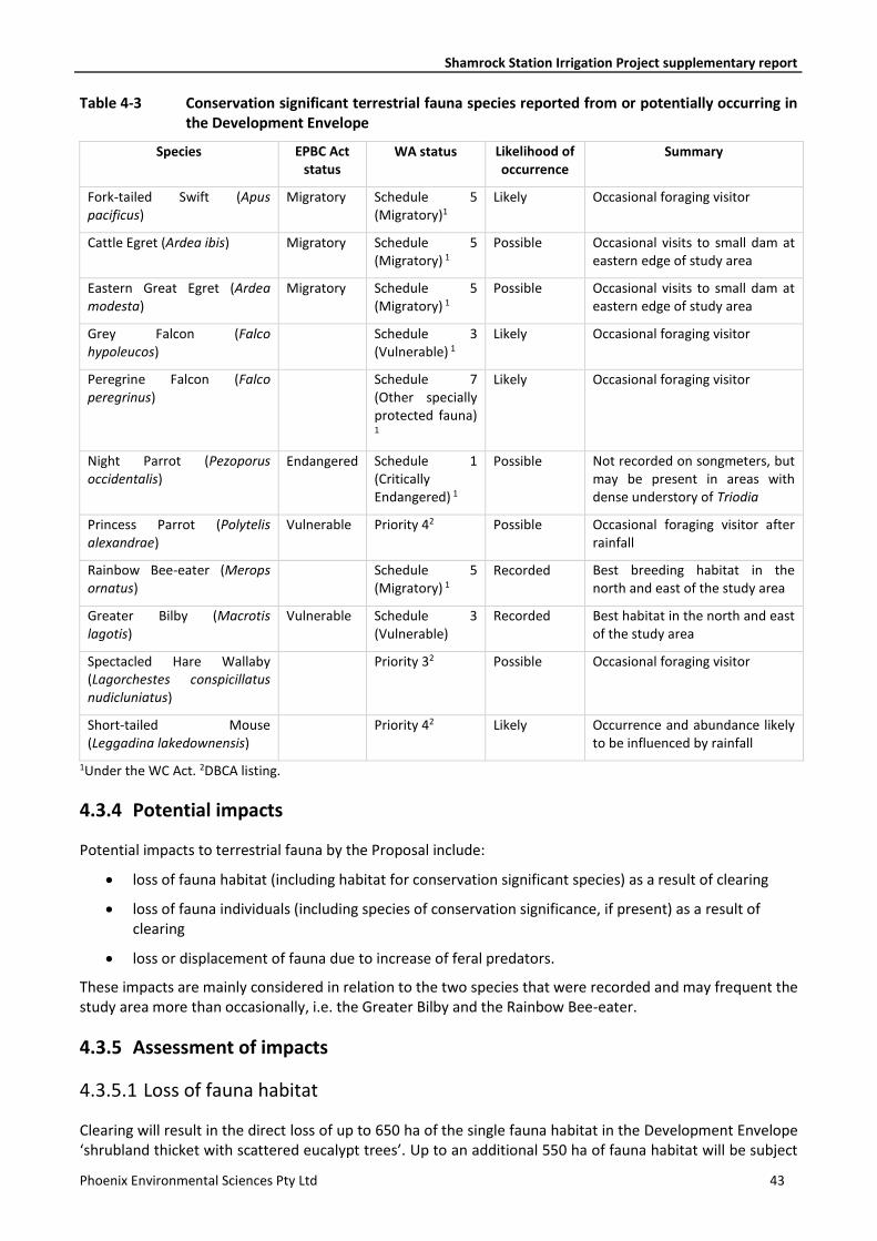
Shamrock Station Irrigation Project supplementary report
Phoenix Environmental Sciences Pty Ltd 43
Table 4-3 Conservation significant terrestrial fauna species reported from or potentially occurring in the Development Envelope
Species EPBC Act status
WA status Likelihood of occurrence
Summary
Fork-tailed Swift (Apus pacificus)
Migratory Schedule 5 (Migratory)1
Likely Occasional foraging visitor
Cattle Egret (Ardea ibis) Migratory Schedule 5 (Migratory) 1
Possible Occasional visits to small dam at eastern edge of study area
Eastern Great Egret (Ardea modesta)
Migratory Schedule 5 (Migratory) 1
Possible Occasional visits to small dam at eastern edge of study area
Grey Falcon (Falco hypoleucos)
Schedule 3 (Vulnerable) 1
Likely Occasional foraging visitor
Peregrine Falcon (Falco peregrinus)
Schedule 7 (Other specially protected fauna)
1
Likely Occasional foraging visitor
Night Parrot (Pezoporus occidentalis)
Endangered Schedule 1 (Critically Endangered) 1
Possible Not recorded on songmeters, but may be present in areas with dense understory of Triodia
Princess Parrot (Polytelis alexandrae)
Vulnerable Priority 42 Possible Occasional foraging visitor after rainfall
Rainbow Bee-eater (Merops ornatus)
Schedule 5 (Migratory) 1
Recorded Best breeding habitat in the north and east of the study area
Greater Bilby (Macrotis lagotis)
Vulnerable Schedule 3 (Vulnerable)
Recorded Best habitat in the north and east of the study area
Spectacled Hare Wallaby (Lagorchestes conspicillatus nudicluniatus)
Priority 32 Possible Occasional foraging visitor
Short-tailed Mouse (Leggadina lakedownensis)
Priority 42 Likely Occurrence and abundance likely to be influenced by rainfall
1Under the WC Act. 2DBCA listing.
4.3.4 Potential impacts
Potential impacts to terrestrial fauna by the Proposal include:
• loss of fauna habitat (including habitat for conservation significant species) as a result of clearing
• loss of fauna individuals (including species of conservation significance, if present) as a result of clearing
• loss or displacement of fauna due to increase of feral predators.
These impacts are mainly considered in relation to the two species that were recorded and may frequent the study area more than occasionally, i.e. the Greater Bilby and the Rainbow Bee-eater.
4.3.5 Assessment of impacts
4.3.5.1 Loss of fauna habitat
Clearing will result in the direct loss of up to 650 ha of the single fauna habitat in the Development Envelope ‘shrubland thicket with scattered eucalypt trees’. Up to an additional 550 ha of fauna habitat will be subject
Shamrock Station Irrigation Project supplementary report
Phoenix Environmental Sciences Pty Ltd 44
to disturbance through designation as vegetation buffer around the pivots where intensive stocking of cattle is likely to degrade the habitat. This equates to loss of 47% of all fauna habitat within the Development Envelope (1,200 ha of 2,547 ha) and 34% of all fauna habitat within the study area for the fauna survey (1,200 ha of 3,505 ha).
The shrubland thicket represents habitat for the two conservation significant species encountered during the field survey, the Greater Bilby and the Rainbow Bee-eater. However, the area proposed for clearing will result in the loss of habitat that is of inferior quality to both species due to the presence of dense understory vegetation of spinifex (Triodia).
Greater Bilby. The Greater Bilby or Dalgyte is a rabbit-sized marsupial that originally occupied over 70% of the Australian mainland. It now occurs in less than 20% of its original range, with remaining WA populations predominantly in the Great Sandy and Gibson Deserts. Habitat preferences of the Greater Bilby include hummock grassland in plains and alluvial areas, open tussock grassland on uplands and hills, and mulga woodland/shrubland on ridges and rises. The species is highly mobile and can have large foraging ranges. Home ranges in sandy deserts are usually temporary and may shift in response to changes in food availability. The decline in Greater Bilby distribution is thought to be due to effects on food availability from changing fire regimes, drought, grazing by rabbits and livestock, and predation by the Red Fox and feral Cat.
The species appears regionally comparatively common in the Proposal vicinity with previous DBCA NatureMap records from approximately 1 km south west of the Development Envelope and multiple sightings within 10 km south of the Development Envelope (Phoenix 2017).
The Bilby was recorded five times during the field survey from aged and weathered foraging diggings. One record was from within the Development Envelope and four within 1 km of the Development Envelope (Figure 2-12). No recent tracks or burrows of the species were recorded during the field survey indicating a low persistence of the species in the area.
The habitat within and beyond the study area was a mix of high and low quality for the Greater Bilby. The majority of survey plots within the study area were rated of low value. Habitat considered of high suitability was recorded primarily along the eastern edge of the study area, including plots outside the eastern boundary, and along the western edge but mostly in plots outside the study area. High habitat quality were areas supporting a range of vegetation structures without dense understory that would restrict movement of the species, and presence of substrates permitting burrowing by the species. Low suitability plots were typically characterised by very dense understory. As such, the loss of inferior foraging habitat for the Bilby is not expected to significantly adversely affect the conservation status of this species.
Rainbow Bee‐eater.
The Rainbow Bee-eater was recorded six times during the field survey. It is considered likely to frequently occur within the Development Envelope to forage and is likely to nest in areas where suitable substrates without vegetation cover are present to allow the construction of burrows.
Threats to the Rainbow Bee-eater as a result of the Proposal are limited to loss of foraging and potential nesting habitat as a result of clearing. Nesting habitat was limited to the eastern edge of the study are where the understory vegetation is less dense. Given the extensive occurrence of suitable foraging and potential nesting habitat for the Rainbow Bee-eater throughout the Pindanland subregion, it is unlikely that the habitat in the study area is significant for this species. As such, the loss of foraging and potential nesting sites for the Rainbow Bee-eater are not expected to significantly adversely affect the conservation status of this species.
Due to the large extent of the predominant fauna habitat in the region, almost all of which remains in pre-European condition, the loss of up to 1,200 ha as part of the Proposal is not considered significant, in particular as no resident populations of any conservation significant species were found in the Development Envelope. Only low quality habitat, that may occasionally be frequented by Greater Bilby and Rainbow Bee-eater, will be destroyed and will not lead to a change of the conservation rating of these species.
The habitat loss may be of minor significance to the local populations of the Greater Bilby; however, the species is highly mobile and therefore able to avoid disturbed areas.
Shamrock Station Irrigation Project supplementary report
Phoenix Environmental Sciences Pty Ltd 45
The habitat that will be impacted ‘Shrubland thicket with scattered eucalypt trees’ is abundant throughout the Pindanland bioregion. At a regional scale, it is represented as Vegetation Association 699 (Beeston et al. 2001), that covers almost 5 mio ha and which has 99% of its pre-European extent remaining (Government of Western Australia 2016).
4.3.5.2 Loss of individuals
Loss of individuals of Greater Bilby caused by the clearing process is possible, and may in particular affect breeding individuals hiding in burrows and their young.
Loss of individuals during the construction process, in particular breeding animals and their offspring in burrows is possible. However, no burrows of either Greater Bilby or Rainbow Bee-eater were detected during fauna surveys and the indicative work area largely occurs in habitat unsuitable for burrow construction. It is therefore unlikely that there will be a a loss of individuals of these species.
4.3.5.3 Increase of predators
All invasive fauna species that are known to be harmful to the Greater Bilby, through either predation, competition or indirectly through habitat degradation, are known to occur within or in the vicinity of Shamrock Station. The proposed action is therefore unlikely to introduce any new invasive fauna species to the area. However, the increase in resource availability (i.e. water and food) may lead to an increase in the abundance of some feral animal species that are harmful to Bilbies. For example:
• Increased abundance of rabbits, wallabies or other prey animals due to increased food availability which may lead to degradation of habitat and decrease Bilby access to food resources and burrow sites. It is noted though that rabbits are not present in high abundance in the La Grange area.
• Increased abundance of introduced predators (foxes or cats) due to increased water availability and rabbit abundance. Both species are considered to be a threat to the Greater Bilby (Threatened Species Scientific Committee 2016), although their relative effect is not consistent throughout the Bilby’s distribution. For example, foxes are more abundant, and therefore a more significant threat in the southern Bilby populations (the Development Envelope is located within the distribution of the northern range of the species); however, foxes expanding into Greater Bilby habitat may increase mortality through predation (Bradley et al. 2015).
4.3.6 Mitigation
Measures to avoid or reduce impacts on Greater Bilby are being implemented in the design stage of the Proposal. In particular, the indicative work area has been revised to avoid clearing of areas rated as high value habitat in particular towards the east of the study area (Figure 2-12).
Habitat rated as high value for the species, that is contiguous with high value habitat outside the Development Envelope (mainly along the eastern and northern boundary), will be retained effectively leaving a wide corridor for movement of the species through the Development Envelope. One irrigation pivot needs to be established within the Bilby habitat corridor as the bore infrastructure is already in place; however, the pivot location has been moved westward, way from the boundary to retain the corridor at this location.
Management measures for Terrestrial Fauna are identified in the draft EMP provisions table (Appendix 4). These will include, but not be limited to the following:
• existing tracks will be utilised where possible
• clearing of native vegetation for the Proposal will be limited to that which is strictly required
• cattle will be maintained within fenced areas to avoid disturbance to surrounding habitats including areas known to and are likely to support the Greater Bilby
Shamrock Station Irrigation Project supplementary report
Phoenix Environmental Sciences Pty Ltd 46
• pre-clearance surveys will be undertaken for Greater Bilby prior to clearing to ensure no burrows used by the species at the time of clearing are destroyed; if any active Greater Bilby burrows are recorded individuals will be relocated to suitable habitat within Shamrock Station
• feral animal control of rabbits, cats and foxes (or other species as required) will be undertaken periodically to prevent an increase in feral animal abundance and consequential detrimental impact on Greater Bilby.
As the Proposal will meet the EPA objective for Terrestrial Fauna, no offset is required.
4.3.7 Predicted outcome
The Proposal is not expected to affect the conservation status of any Threatened or Priority taxa, SRE species or fauna habitats, or have a significant effect on the representation of species or habitats at a local or regional level.
4.4 HYDROLOGICAL PROCESSES
4.4.1 EPA objective
The EPA’s objective for the factor hydrological processes is to maintain the hydrological regimes of groundwater and surface water so that environmental values are protected (EPA 2016b). These values include water dependent ecosystems, amenity, cultural values, recreation, public drinking water supplies, and agricultural and industry use of water.
4.4.2 Policy and guidance
The following EPA guideline has been considered in the assessment of hydrological processes with respect to the EPA objective:
• EPA Environmental Factor Guideline: Hydrological Processes (EPA 2016b).
4.4.3 Receiving environment
With respect to hydrological processes, environmental values are either in-situ (i.e. water dependent wetlands or groundwater ecosystems) or extractive (i.e. consumptive use for public water supply, agriculture and industry) (EPA 2016b).
A H3 hydrogeological assessment was conducted for the Project to support a water licence application for 22 GL/year (IGS 2017) (Appendix 1). This assessment modelled the hydrological changes in the Broome Sandstone Aquifer based on an abstraction rate of approximately 9.5 GL/year within the potential impact zone, including predicted drawdown at Injudinah Swamp and locations of other groundwater users; and predicted movement of the saltwater interface.
In-situ environmental values
Nine wetlands in the north-western Sandy Desert are ecologically significant (V & C Semeniuk Research Group 2000). Four of these are also listed as of conservation value nationally or internationally, i.e. they are Ramsar wetlands and/or are on the Australian Directory of Important Wetlands (DIW):
Injudinah Swamp and associated wetlands – 10 km south-west of the study area (Figure 2-2)
• Roebuck Bay (Ramsar, DIW) – approximately 21 km north
• Rowbuck Plains System (DIW) – approximately 20 km north
• La Grange Bay – approximately 40 km south-west
• Cape Bossut embayment – approximately 50 km south-west
Shamrock Station Irrigation Project supplementary report
Phoenix Environmental Sciences Pty Ltd 47
• Eighty Mile Beach (Ramsar, DIW) – approximately 80 km south
• Munro Springs – approximately 80 km south
• Mandora Salt Marsh (DIW) – approximately 145 km south
• Salt Creek System (part of the Mandora Marshes) – 145 km south.
All but Injudinah Swamp and its associated wetlands are either marine systems and therefore not subject to impacts from the Project (i.e. Cape Bossut, La Grange Bay) and/or too distant from the Project to be affected by modelled hydrological changes (IGS 2017).
Forty-three potential groundwater dependent wetlands have been identified within the La Grange groundwater area (Wright et al. 2016), twelve of which are part of the Injudinah Swamp system. All others were at least 40 km away from the Development Envelope and are therefore not considered to be affected by hydrological changes from the Project (IGS 2017).
A total of 131 groundwater related wetlands were identified of specific cultural value to the Karajarri and other traditional owners in the La Grange area. Based on available mapping, none of these are present within the Development Envelope (Yu 1999). The closest are nine wetlands, all associated with Injudinah Swamp. All others are too far away to be impacted by the modelled hydrological changes (IGS 2017).
Two potentially groundwater dependent PECs are within approximately 10–15 km south-west of the Development Envelope, both associated with Injudinah Swamp (Figure 2-2), “Kimberley Vegetation Association 37” (Priority 3) and “Roebuck Land System” (Priority 3) (DBCA 2017b). Both systems feature teatree (Melaleuca sp.) thickets that may be susceptible to changes in groundwater levels. However, principal threats associated with these associations do not specifically recognise groundwater changes, but include altered fire regimes at a landscape scale leading to loss of trees and shrubs, overgrazing and weed invasion (buffel grass) (DBCA 2017b).
Based on a number of factors as listed above, Injudinah Swamp is the only groundwater dependent significant system that may be impacted by water abstraction for the Project. It represents a wetland situated along the contact zone of the Pindan woodlands and the tidal marshes of La Grange Bay. The wetland is maintained by seepage of freshwater from the regional aquifers interfacing with the muds of the tidal zone (V & C Semeniuk Research Group 2000).
There are no wild and scenic rivers, poorly represented wetland types or natural springs and pools in the vicinity of the Development Envelope.
At the ocean interface, a saltwater toe penetrates the base of Broome Sandstone aquifer due to the higher density of saltwater (Figure 2-6). This toe interface occurs approximately between 3.5–4.2 km from the coast at the closest point to the Project (IGS 2017).
Extractive values
Twelve existing users were identified in the La Grange area that may be of relevance for the Proposal (Figure 2-2). The nine closest were subject to hydrological modelling to assess the potential impact by groundwater abstraction for the Proposal (~9.5 GL/annum; Table 4-4).
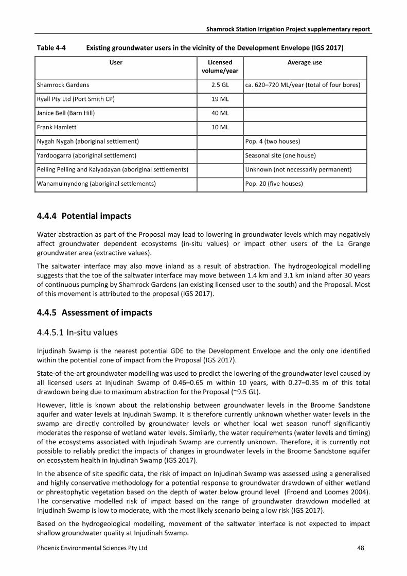
Shamrock Station Irrigation Project supplementary report
Phoenix Environmental Sciences Pty Ltd 48
Table 4-4 Existing groundwater users in the vicinity of the Development Envelope (IGS 2017)
User Licensed volume/year
Average use
Shamrock Gardens 2.5 GL ca. 620–720 ML/year (total of four bores)
Ryall Pty Ltd (Port Smith CP) 19 ML
Janice Bell (Barn Hill) 40 ML
Frank Hamlett 10 ML
Nygah Nygah (aboriginal settlement) Pop. 4 (two houses)
Yardoogarra (aboriginal settlement) Seasonal site (one house)
Pelling Pelling and Kalyadayan (aboriginal settlements) Unknown (not necessarily permanent)
Wanamulnyndong (aboriginal settlements) Pop. 20 (five houses)
4.4.4 Potential impacts
Water abstraction as part of the Proposal may lead to lowering in groundwater levels which may negatively affect groundwater dependent ecosystems (in-situ values) or impact other users of the La Grange groundwater area (extractive values).
The saltwater interface may also move inland as a result of abstraction. The hydrogeological modelling suggests that the toe of the saltwater interface may move between 1.4 km and 3.1 km inland after 30 years of continuous pumping by Shamrock Gardens (an existing licensed user to the south) and the Proposal. Most of this movement is attributed to the proposal (IGS 2017).
4.4.5 Assessment of impacts
4.4.5.1 In-situ values
Injudinah Swamp is the nearest potential GDE to the Development Envelope and the only one identified within the potential zone of impact from the Proposal (IGS 2017).
State-of-the-art groundwater modelling was used to predict the lowering of the groundwater level caused by all licensed users at Injudinah Swamp of 0.46–0.65 m within 10 years, with 0.27–0.35 m of this total drawdown being due to maximum abstraction for the Proposal (~9.5 GL).
However, little is known about the relationship between groundwater levels in the Broome Sandstone aquifer and water levels at Injudinah Swamp. It is therefore currently unknown whether water levels in the swamp are directly controlled by groundwater levels or whether local wet season runoff significantly moderates the response of wetland water levels. Similarly, the water requirements (water levels and timing) of the ecosystems associated with Injudinah Swamp are currently unknown. Therefore, it is currently not possible to reliably predict the impacts of changes in groundwater levels in the Broome Sandstone aquifer on ecosystem health in Injudinah Swamp (IGS 2017).
In the absence of site specific data, the risk of impact on Injudinah Swamp was assessed using a generalised and highly conservative methodology for a potential response to groundwater drawdown of either wetland or phreatophytic vegetation based on the depth of water below ground level (Froend and Loomes 2004). The conservative modelled risk of impact based on the range of groundwater drawdown modelled at Injudinah Swamp is low to moderate, with the most likely scenario being a low risk (IGS 2017).
Based on the hydrogeological modelling, movement of the saltwater interface is not expected to impact shallow groundwater quality at Injudinah Swamp.
Shamrock Station Irrigation Project supplementary report
Phoenix Environmental Sciences Pty Ltd 49
4.4.5.2 Extractive values
Shamrock Gardens is the closest existing licensed groundwater user to the Proposal. The total drawdown predicted at Shamrock Gardens after 10 years of continuous pumping by both Shamrock Gardens and the proposed development is 1.64–2.59 m. Of this, 0.77–0.78 m of drawdown is attributed to the Proposal (IGS 2017).
The next greatest impact is observed at the community of Nygah Nygah, which would experience a drawdown of 0.42–0.61 m. Of this, 0.41–0.29 m of drawdown would be attributed to the Proposal. Predicted impacts after 10 years of pumping at all other identified existing users are less than 20 cm.
The drawdown curves all begin to flatten off after 10 years, meaning that, with the exception of Shamrock Gardens, additional impacts after 30 years are all less than 25 cm (IGS 2017). However, any modelling beyond 10 years should be considered of low reliability due to unknown parameters, for example in relation to changes in climate and potential additional users.
The modelled changes in drawdown do not represent a significant impact on other users of the La Grange groundwater subarea.
Potential movement of the saltwater interface may affect other grounwater users if not monitored and managed. Early warning monitoring is proposed specifically to facilitate early detection of potential movement.
4.4.6 Mitigation
The proposal area has been relocated within Shamrock Station in comparison to early planning stages to be situated as far as possible from Injudinah Swamp based on hydrogeological modelling of groundwater abstraction on this wetland.
A draft Detailed Operating Strategy has been prepared for the project to meet requirements for the groundwater licence; this document is currently in development in consultation with DWER. The strategy outlines the proposed groundwater monitoring program to be implemented across a suite of production bores, onsite monitoring bores and regional monitoring bores. The location of proposed monitoring bores is shown in Figure 2-2 and inclues a monitoring point at Injudinah Swamp, closest to the zone of drawdown, as well as locations aimed at monitoring drawdown on other groundwater users and movement of the saltwater interface.
Key draft management provisions are provided in the EMP provisions table (Appendix 4). Monitoring parameters will include, but are not limited to:
• baseline groundwater quality in new and existing production and monitoring bores
• water use in production bores using flowmeter readings
• field electrical conductivity and pH
• groundwater levels in onsite and regional monitoring bores
• groundwater chemistry in production and monitoring bores
• total nitrogen in monitoring bores and Injudinah Swamp
• groundwater pressure and barometric pressure
• surface water levels, depth of water level and surface water quality at Injudinah Swamp.
Further baseline groundwater analysis will be undertaken as new monitoring bores are established. Baseline surface water parameters will be established at Injudinah Swamp.
Vegetation monitoring will be undertaken at Injudinah Swamp and within the area delineated by DBCA as the potentially groundwater dependent PEC “Kimberley Vegetation Association 37” if groundwater and surface level trigger values are exceeeded. The “Roebuck Land System” PEC is located further away from the
Shamrock Station Irrigation Project supplementary report
Phoenix Environmental Sciences Pty Ltd 50
area of groundwater drawdown, although the extent of the PEC within the swamp is not properly mapped. It expected that any effect on the two communities would display initially in groundwater dependent vegetation of the former because it is located closest to the Development Envelope. A vegetation assessment will be undertaken at Injudinah Swamp in October 2017 to establish a baseline dataset and transect sites for the vegetation monitoring program in the event it is triggered.
The monitoring program will allow the impacts of the proposed development on the wetland and associated groundwater dependent communities to be better predicted, identified early and mitigated if necessary.
4.4.7 Predicted outcome
The Proposal is not expected to considerably affect the hydrological processes governing in-situ and extractive values in the vicinity of the Project. Based on conservative assumptions, there remains a low to moderate risk of impact due to an additional drawdown of 0.46–0.65 m at Injudinah Swamp.
5 OTHER ENVIRONMENTAL FACTORS
A desktop assessment was initially undertaken for all environmental factors listed by the EPA (2016h) to inform the preliminary identification of key environmental factors. Other potential environmental factors that were identified in the review and for which potential impacts are not considered to be significant are summarised in Table 5-1.
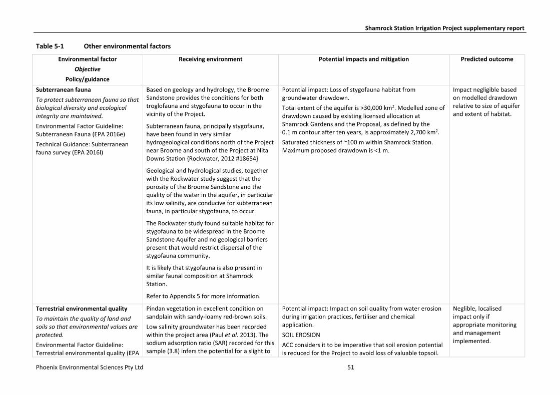
Shamrock Station Irrigation Project supplementary report
Phoenix Environmental Sciences Pty Ltd 51
Table 5-1 Other environmental factors
Environmental factor
Objective
Policy/guidance
Receiving environment Potential impacts and mitigation Predicted outcome
Subterranean fauna
To protect subterranean fauna so that biological diversity and ecological integrity are maintained.
Environmental Factor Guideline: Subterranean Fauna (EPA 2016e)
Technical Guidance: Subterranean fauna survey (EPA 2016l)
Based on geology and hydrology, the Broome Sandstone provides the conditions for both troglofauna and stygofauna to occur in the vicinity of the Project.
Subterranean fauna, principally stygofauna, have been found in very similar hydrogeological conditions north of the Project near Broome and south of the Project at Nita Downs Station {Rockwater, 2012 #18654}
Geological and hydrological studies, together with the Rockwater study suggest that the porosity of the Broome Sandstone and the quality of the water in the aquifer, in particular its low salinity, are conducive for subterranean fauna, in particular stygofauna, to occur.
The Rockwater study found suitable habitat for stygofauna to be widespread in the Broome Sandstone Aquifer and no geological barriers present that would restrict dispersal of the stygofauna community.
It is likely that stygofauna is also present in similar faunal composition at Shamrock Station.
Refer to Appendix 5 for more information.
Potential impact: Loss of stygofauna habitat from groundwater drawdown.
Total extent of the aquifer is >30,000 km2. Modelled zone of drawdown caused by existing licensed allocation at Shamrock Gardens and the Proposal, as defined by the 0.1 m contour after ten years, is approximately 2,700 km2.
Saturated thickness of ~100 m within Shamrock Station. Maximum proposed drawdown is <1 m.
Impact negligible based on modelled drawdown relative to size of aquifer and extent of habitat.
Terrestrial environmental quality
To maintain the quality of land and soils so that environmental values are protected.
Environmental Factor Guideline: Terrestrial environmental quality (EPA
Pindan vegetation in excellent condition on sandplain with sandy-loamy red-brown soils.
Low salinity groundwater has been recorded within the project area (Paul et al. 2013). The sodium adsorption ratio (SAR) recorded for this sample (3.8) infers the potential for a slight to
Potential impact: Impact on soil quality from water erosion during irrigation practices, fertiliser and chemical application.
SOIL EROSION
ACC considers it to be imperative that soil erosion potential is reduced for the Project to avoid loss of valuable topsoil.
Neglible, localised impact only if appropriate monitoring and management implemented.
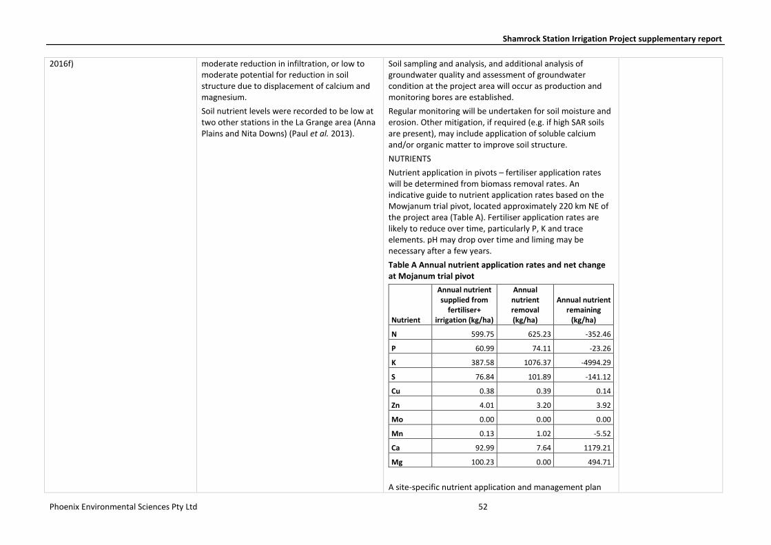
Shamrock Station Irrigation Project supplementary report
Phoenix Environmental Sciences Pty Ltd 52
2016f) moderate reduction in infiltration, or low to moderate potential for reduction in soil structure due to displacement of calcium and magnesium.
Soil nutrient levels were recorded to be low at two other stations in the La Grange area (Anna Plains and Nita Downs) (Paul et al. 2013).
Soil sampling and analysis, and additional analysis of groundwater quality and assessment of groundwater condition at the project area will occur as production and monitoring bores are established.
Regular monitoring will be undertaken for soil moisture and erosion. Other mitigation, if required (e.g. if high SAR soils are present), may include application of soluble calcium and/or organic matter to improve soil structure.
NUTRIENTS
Nutrient application in pivots – fertiliser application rates will be determined from biomass removal rates. An indicative guide to nutrient application rates based on the Mowjanum trial pivot, located approximately 220 km NE of the project area (Table A). Fertiliser application rates are likely to reduce over time, particularly P, K and trace elements. pH may drop over time and liming may be necessary after a few years.
Table A Annual nutrient application rates and net change at Mojanum trial pivot
Nutrient
Annual nutrient supplied from
fertiliser+ irrigation (kg/ha)
Annual nutrient removal (kg/ha)
Annual nutrient remaining
(kg/ha)
N 599.75 625.23 -352.46
P 60.99 74.11 -23.26
K 387.58 1076.37 -4994.29
S 76.84 101.89 -141.12
Cu 0.38 0.39 0.14
Zn 4.01 3.20 3.92
Mo 0.00 0.00 0.00
Mn 0.13 1.02 -5.52
Ca 92.99 7.64 1179.21
Mg 100.23 0.00 494.71
A site-specific nutrient application and management plan
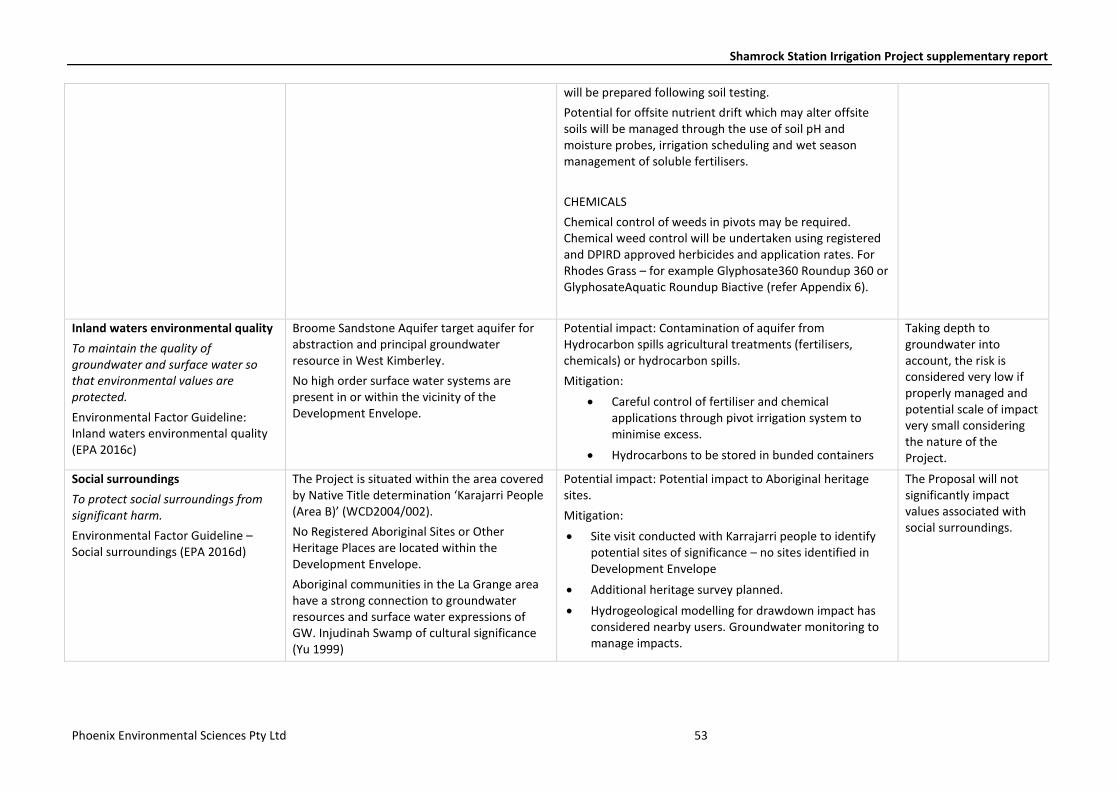
Shamrock Station Irrigation Project supplementary report
Phoenix Environmental Sciences Pty Ltd 53
will be prepared following soil testing.
Potential for offsite nutrient drift which may alter offsite soils will be managed through the use of soil pH and moisture probes, irrigation scheduling and wet season management of soluble fertilisers.
CHEMICALS
Chemical control of weeds in pivots may be required. Chemical weed control will be undertaken using registered and DPIRD approved herbicides and application rates. For Rhodes Grass – for example Glyphosate360 Roundup 360 or GlyphosateAquatic Roundup Biactive (refer Appendix 6).
Inland waters environmental quality
To maintain the quality of groundwater and surface water so that environmental values are protected.
Environmental Factor Guideline: Inland waters environmental quality (EPA 2016c)
Broome Sandstone Aquifer target aquifer for abstraction and principal groundwater resource in West Kimberley.
No high order surface water systems are present in or within the vicinity of the Development Envelope.
Potential impact: Contamination of aquifer from Hydrocarbon spills agricultural treatments (fertilisers, chemicals) or hydrocarbon spills.
Mitigation:
• Careful control of fertiliser and chemical applications through pivot irrigation system to minimise excess.
• Hydrocarbons to be stored in bunded containers
Taking depth to groundwater into account, the risk is considered very low if properly managed and potential scale of impact very small considering the nature of the Project.
Social surroundings
To protect social surroundings from significant harm.
Environmental Factor Guideline – Social surroundings (EPA 2016d)
The Project is situated within the area covered by Native Title determination ‘Karajarri People (Area B)’ (WCD2004/002).
No Registered Aboriginal Sites or Other Heritage Places are located within the Development Envelope.
Aboriginal communities in the La Grange area have a strong connection to groundwater resources and surface water expressions of GW. Injudinah Swamp of cultural significance (Yu 1999)
Potential impact: Potential impact to Aboriginal heritage sites.
Mitigation:
• Site visit conducted with Karrajarri people to identify potential sites of significance – no sites identified in Development Envelope
• Additional heritage survey planned.
• Hydrogeological modelling for drawdown impact has considered nearby users. Groundwater monitoring to manage impacts.
The Proposal will not significantly impact values associated with social surroundings.
Shamrock Station Irrigation Project supplementary report
Phoenix Environmental Sciences Pty Ltd 54
6 MATTERS OF NATIONAL ENVIRONMENTAL SIGNIFICANCE
The Proposal was referred to the Australian Government Minister for the Environment and Energy under the EPBC Act on 7 August 2017 (EPBC 2017/8004) for potential impacts to Greater Bilby (Macrotis lagotis) which is listed as Vulnerable under the EPBC Act.
7 HOLISTIC IMPACT ASSESSMENT
The mitigation hierarchy has been applied to the Proposal with emphasis on avoiding impacts to significant environmental values, including Priority Flora, habitat for significant fauna and groundwater dependent ecosystems. Mitigation and management measures will further reduce the risk of impact to environmental values.
Residual environmental impacts are not expected to be significant for any environmental factors. With implementation of the proposed mitigation and management measures, it is considered that the Proposal will meet the EPA’s objective for each environmental factor.

Shamrock Station Irrigation Project supplementary report
Phoenix Environmental Sciences Pty Ltd 55
REFERENCES Armstrong, G. 2008. Triodia caelestialis (Triodieae: Chloridoideae: Poaceae), a new species from the central
Kimberley, Western Australia. Journal of the Royal Society of Western Australia 91: 313–317. Beard, J. S. 1979. Kimberley, 1:1 000,000 vegetation series: explanatory notes to sheet 1, the vegetation of
the Kimberley area. University of Western Australia, Nedlands, WA. Beeston, G. R., Hopkins, A. J. M. & Shephard, D. P. (eds). 2001. Land-use and vegetation, Western Australia.
Agriculture Western Australia, South Perth, WA. Bradley, K., Lees, C., Lundie-Jenkins, G., Copley, P., Paltridge, R., Dziminski, M., Southgate, R., Nally, S. &
Kemp, L. 2015. 2015 Greater Bilby Conservation Summit and Interim Conservation Plan: an Initiative of the Save the Bilby Fund. Available at: https://savethebilbyfund.com/volunteer/stbf-news-events/greater-bilby-recovery-summit-2015-report-and-interim-conser
Cowie, I. D. 2004. New species and lectotypifications of some reticulate-nerved Tephrosia (Fabaceae) from north-west Australia and the genus Paratephrosia re-evaluated. Nuytsia 15: 163–186.
DAFWA. 2016. Western Australian Organism List. Department of Agriculutire and Food, Government of Western Australia, South Perth, WA. Available at: https://www.agric.wa.gov.au/organisms (accessed 11 March 2016).
DAFWA, DEC & DRDL. 2012. Non indigenous plant species list for Western Australia's rangelands – Permitted (Green List) and Not Permitted (Red List). Department of Agriculture and Food Western Australia, Department of Environment and Conservation and Department of Regional Development and Lands, Perth, WA. Fact sheet.
DBCA. 2017a. Florabase. Department of Biodiversirty, Conservation and Attractions. Available at: http://florabase.dpaw.wa.gov.au/
DBCA. 2017b. Priority Ecological Communities for Western Australia version 27. Department of Biodiversirty, Conservation and Attractions, Kensington, WA. Available at: https://www.dpaw.wa.gov.au/plants-and-animals/threatened-species-and-communities/wa-s-threatened-ecological-communities
DEC. 1999. Environmental weed strategy for Western Australia. Department of Environment and Conservation, Kensington, WA. Available at: http://www.dpaw.wa.gov.au/images/documents/plants-animals/plants/weeds/environmental_weed_strategy_wa.pdf (accessed 25 November 2015).
DPaW. 2017a. Florabase. Department of Parks and Wildlife, Perth, WA. Available at: https://florabase.dpaw.wa.gov.au/
DPaW. 2017b. Interim guideline for preliminary surveys of Night Parrot (Pezoporus occidentalis) in Western Australia. Department of Parks and Wildlife, Kensington, WA. Available at: https://www.dpaw.wa.gov.au/images/documents/plants-animals/animals/interim_guideline_for_night_parrot_survey.pdf
EPA. 2016a. Environmental Factor Guideline: Flora and vegetation. Environmental Protection Authority, Perth, WA. Available at: http://www.epa.wa.gov.au/sites/default/files/Policies_and_Guidance/Guideline-Flora-Vegetation-131216_4.pdf (accessed 20 December 2016).
EPA. 2016b. Environmental Factor Guideline: Hydrological processes. Environmental Protection Authority, Perth, WA. Available at: http://www.epa.wa.gov.au/sites/default/files/Policies_and_Guidance/Guideline-Hydrological-Processes-131216_3.pdf (accessed 20 December 2016).
EPA. 2016c. Environmental Factor Guideline: Inland waters environmental quality. Environmental Protection Authority, Perth, WA. Available at: http://www.epa.wa.gov.au/sites/default/files/Policies_and_Guidance/Guideline-Inland-Waters-Environmental-Quality-131216_1.pdf (accessed 20 February 2016).
EPA. 2016d. Environmental Factor Guideline: Social surroundings. Environmental Protection Authority, Perth, WA. Available at: http://www.epa.wa.gov.au/sites/default/files/Policies_and_Guidance/Guideline-Social-Surroundings-131216_2.pdf
EPA. 2016e. Environmental Factor Guideline: Subterranean fauna. Environmental Protection Authority, Perth, WA. Available at:

Shamrock Station Irrigation Project supplementary report
Phoenix Environmental Sciences Pty Ltd 56
http://www.epa.wa.gov.au/sites/default/files/Policies_and_Guidance/Guideline-Subterranean-Fauna-131216_3.pdf (accessed 20 December 2016).
EPA. 2016f. Environmental Factor Guideline: Terrestrial environmental quality. Environmental Protection Authority, Perth, WA. Available at: http://www.epa.wa.gov.au/sites/default/files/Policies_and_Guidance/Guideline-Terrestrial-Environmental-Quality-131216_2.pdf (accessed 20 December 2016).
EPA. 2016g. Environmental Factor Guideline: Terrestrial fauna. Environmental Protection Authority, Perth, WA. Available at: http://www.epa.wa.gov.au/sites/default/files/Policies_and_Guidance/Guideline-Terrestrial-Fauna-131216_3.pdf (accessed 20 December 2016).
EPA. 2016h. Statement of environmental principles, factors and objectives. Environmental Protection Authority, Perth, WA. Available at: http://www.epa.wa.gov.au/sites/default/files/Policies_and_Guidance/Statement%20of%20Environmental%20Principles%2C%20factors%20and%20objectives_Dec16_1.pdf (accessed 20 December 2016).
EPA. 2016i. Technical Guidance: Flora and vegetation surveys for Environmental Impact Assessment. Environmental Protection Authority, Perth, WA. Available at: http://www.epa.wa.gov.au/sites/default/files/Policies_and_Guidance/EPA%20Technical%20Guidance%20-%20Flora%20and%20Vegetation%20survey_Dec13.pdf (accessed 20 December 2016).
EPA. 2016j. Technical Guidance: Sampling methods for terrestrial vertebrate fauna. Environmental Protection Authority, Perth, WA. Available at: http://epa.wa.gov.au/sites/default/files/Policies_and_Guidance/Tech%20guidance-%20Sampling-TV-fauna-Dec2016.pdf
EPA. 2016k. Technical Guidance: Sampling of short range endemic invertebrate fauna. Environmental Protection Authority, Perth, WA. Available at: http://www.epa.wa.gov.au/sites/default/files/Policies_and_Guidance/Tech%20guidance-%20Sampling-SREs-Dec-2016.pdf (accessed 20 December 2016).
EPA. 2016l. Technical Guidance: Subterranean fauna survey. Environmental Protection Authority, Perth, WA. Available at: http://www.epa.wa.gov.au/sites/default/files/Policies_and_Guidance/Technical%20Guidance-Subterranean%20fauna-Dec2016.pdf (accessed 20 December 2016).
EPA. 2016m. Technical Guidance: Terrestrial fauna surveys. Environmental Protection Authority, Perth, WA. Available at: http://www.epa.wa.gov.au/sites/default/files/Policies_and_Guidance/Tech%20guidance-%20Terrestrial%20Fauna%20Surveys-Dec-2016.pdf (accessed 10 December 2016).
EPA. no date. Instructions on how to prepare an Environmental Review Document. Environmental Protection Authority, Perth, WA. Available at: http://www.epa.wa.gov.au/sites/default/files/Forms_and_Templates/PMI_How%20to%20prepare%20Environmental%20Review%20Document_030317.pdf (accessed 8 August 2017).
Gibson, D. L. 1983. 1:250,000 Geological Series Explanatory Notes. Lagrance, Western Australia. Sheet SE/51-10. Australian Government Publishing Service.
Government of Western Australia. 2016. 2016 Statewide Vegetation Statistics incorporating the CAR Reserve Analysis (Full Report). Current as of October 2016. Department of Parks and Wildlife, Perth. Available at: https://www2.landgate.wa.gov.au/web/guest/downloader
Graham, G. 2001. Dampierland 2 (DL2—Pindanland subregion). In: May, J. E. & McKenzie, N. L. (eds) A biodiversity audit of Western Australia's 53 biogeographical subregions. Department of Conservation and Land Management, Perth, WA, pp. 179–187.
Hill, A. L., Semeniuk, C. A., Semeniuk, V. & Del Marco, A. 1996. Wetlands of the Swan Coastal Plain. Volume 2A: Wetland mapping, classification and evaluation. Water Authority of Western Australia, Western Australian Department of Environmental Protection, Leederville and Perth, WA.
Hurter, J. & Naaykens, J. 2012. Report on the suspected invasiveness of the grass Chloris gayana on Kilto and Wooramel Stations in WA.
Shamrock Station Irrigation Project supplementary report
Phoenix Environmental Sciences Pty Ltd 57
IGS. 2017. Shamrock Station irrigation development. Stage 1 hydrogeological assessment. Innovative Groundwater Solutions, Middleton, SA. Unpublished report prepared for Argyle Cattle Company Pty Ltd.
Kimberley Land Council. 2017. Indigenous Protected Areas. Available at: http://www.klc.org.au/land-sea/indigenous-protected-areas
Paul, R. J., George, R. J. & Gardiner, P. 2013. A review of the Broome Sandstone aquifer in the La Grange area. Department of Agriculture and Food, Perth, WA. Report 387.
Phoenix. 2017. Flora and vegetation survey and terrestrial fauna survey for the Shamrock irrigation Project. Phoenix Environmental Sciences Pty Ltd, Balcatta, WA. Unpublished report prepared for Argyle Cattle Company Pty Ltd.
Rio Tinto. 2013. Wet season (Phase II) survey of Rodes grass Chloris gayana at Kilto Station, WA. Rio Tinto Ltd, Perth, WA.
Rockwater. 2012. Browse LNG Development. Stygofauna survey final report (2011/2012). Rockwater Pty Ltd, Jolimont, WA. Unpublished report prepared for Woodside Energy Ltd.
Schoknecht, N. R. & Payne, A. L. 2011. Land systems of the Kimberley region, Western Australia. Department of Agriculture and Food, Western Australia, Perth.
Shepherd, D. P., Beeston, G. R. & Hopkins, A. J. M. 2002. Native vegetation in Western Australia. Extent, type and status. Department of Agriculture, South Perth, WA. Resource Management Technical Report 249.
Southgate, R. & Moseby, K. 2008. Track-based monitoring for the deserts and rangelands of Australia. WWF Australia, Sydney. Unpublished report prepared for the Threatened Species Network at WWF Australia.
Southgate, R., Paltridge, R., Masters, P. & Nano, T. 2005. An evaluation of transect, plot and aerial survey techniques to monitor the spatial pattern and status of the bilby (Macrotis lagotis) in the Tanami Desert. Wildlife Research 32: 43–52.
Threatened Species Scientific Committee. 2016. Approved Conservation Advice for Macrotis lagotis (greater bilby). Department of the Environment, Canberra. Available at: http://www.environment.gov.au/cgi-bin/sprat/public/publicspecies.pl?taxon_id=282
V & C Semeniuk Research Group. 2000. Wetlands of the northwestern Great Sandy Desert in the La Grange hydrological sub-basin. V & C Semeniuk Research Group, Perth, WA. Unpublished report prepared for the Water and Rivers Commission.
Western Australian Government. 2016. Environmental Impact Assessment (Part IV Divisions 1 and 2) Administrative Procedures 2016. Government Gazette 223: 5601–5616.
Wright, N., George, R., Paul, R. & Raper, G. 2016. Identifying groundwater-dependent wetlands of the Broome Sandstone aquifer in the La Grange groundwater area, Western Australia. Resource management technical report 397. Department of Agriculture and Food, Perth, WA. Available at: https://www.agric.wa.gov.au/assessment-agricultural-expansion/groundwater-dependent-wetlands-broome-sandstone-aquifer-la-grange
Yu, S. 1999. Ngapa Kunangkul: Living Water. The Centre for Anthropological Research, University of Western Australia, Perth, WA. Unpublished report prepared for the Water and Rivers Commission of Western Australia.

Shamrock Station Irrigation Project supplementary report
Phoenix Environmental Sciences Pty Ltd
APPENDICES