session 1 nautical charts even though you have taken a navigation course before… …you will...
TRANSCRIPT

Session 1Session 1Nautical Nautical ChartsCharts

Even though you have taken a navigation course before…
…you will probably learn some new tricks today that will make your boating a little easier and safer.

ObjectivesObjectives To become familiar with data found on
Nautical Chart and how it relates to GPS and the (P)ATON Program.
To understand chart orientation.
To be introduced to the compass rose and understand variation error.
To become familiar with the data found in the General Information Block on a nautical chart.

To understand how depths are
depicted on a nautical chart.
To become familiar with the symbols and abbreviations found on a nautical chart.
To understand the scale of a nautical chart.
To be introduced to the horizontal and vertical datum on a nautical chart and their effect on GPS sets and accuracy.

To be introduced to the symbols that
represent Aids to Navigation on a nautical chart.
To learn to read bottom characteristics on a nautical chart.
To help you understand the critical relationships between your GPS set and a nautical chart.
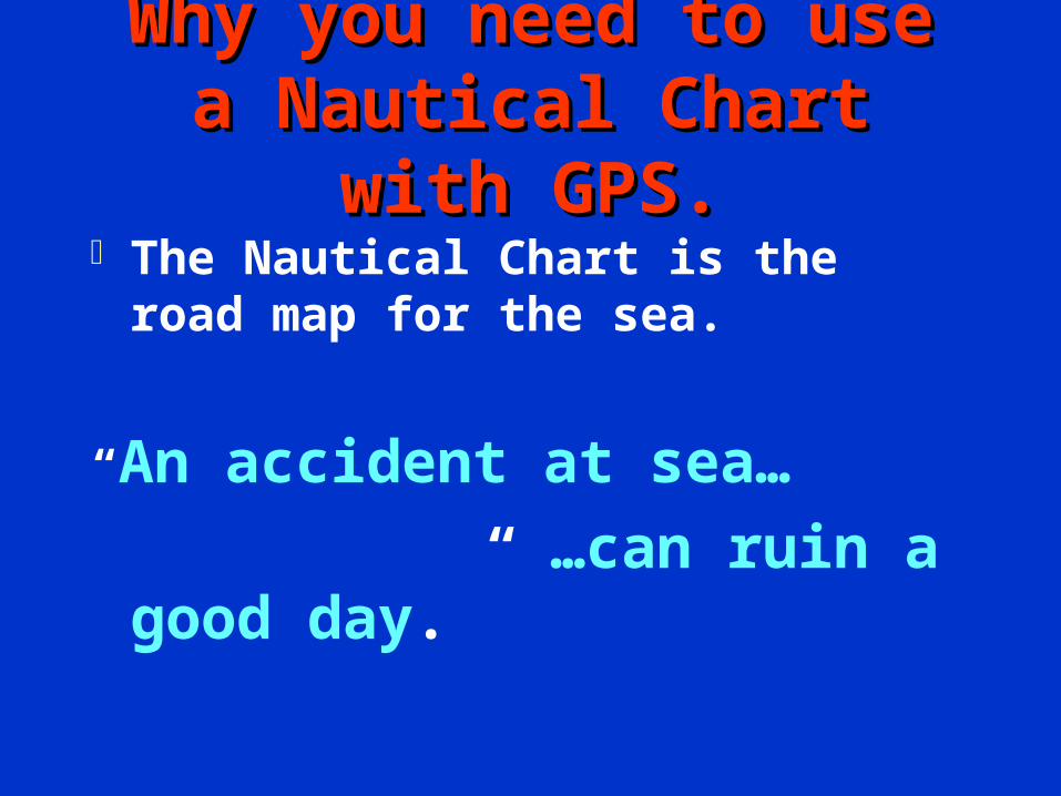
Why you need to use a Why you need to use a Nautical Chart with GPS.Nautical Chart with GPS.
The Nautical Chart is the road map for the sea.
“An accident at sea…
…can ruin a good day.”

Knowing how to read a Knowing how to read a nautical chart helps you:nautical chart helps you:
Identify any hazards and dangers along your course line.
Effectively plot a course on your chart.
GPS NoteGPS Note:: A nautical chart provides a clearer understanding of the geography of the area where your GPS system is operating.
Another GPS Note:
While underway, a paper nautical chart is much easier and safer to use
than a GPS chart plotter.

The Mercator Projection.The Mercator Projection. Converts the earth’s sphere onto a flat
surface usable as a chart.
Projects the earth’s sphere onto a cylinder.
True North is usually at the top of the Mercator projection.
The distance between Meridians of Longitude becomes distorted as you move away from the equator toward the Poles.

The The Mercator Mercator
ProjectionProjection

Mercator Conformal

The Earth as a Sphere.The Earth as a Sphere. True Geographical North is found at the
top of the chart. This is the axis on which the earth spins.
Circumference of the earth is 21,614 nautical miles. [ Divide by 360 degrees to get 60 nm per degree.]
Magnetic North is 016 degrees West of Geographical north in the Boston area.

The Equator
The Prime Meridian

THE EARTH
as aGLOBE
The North Pole
The Magnetic
North Pole
The angular difference from your position on the earth to
the North and Magnetic North poles is called:
“VARIATION ERROR”
GPS Note: Check that your GPS adjusts for
VARIATION automatically!
If not, you must set the VARIATION in your
GPS.
Review your “GPS Operation Manual”
for the procedure for your GPS set.

MAGNETICMAGNETIC NORTH POLENORTH POLE
WESTERLY WESTERLY VARIATIONVARIATION
WESTERLY WESTERLY VARIATIONVARIATION
EASTERLY EASTERLY VARIATIONVARIATION
GEOGRAPHIC GEOGRAPHIC NORTH POLENORTH POLE
EASTERLY EASTERLY VARIATIONVARIATION
EASTERLYAND
WESTERLYVARIATION
ANGULAR ANGULAR DIFFERENCE DIFFERENCE
BETWEEN BETWEEN TRUE NORTH TRUE NORTH
AND AND MAGNETIC NORTHMAGNETIC NORTH
EASTERLYEASTERLYVARIATIONVARIATION

0 variation0 variation
21 E variation21 E variation 10 W variation10 W variation
Isogonic LinesIsogonic Lines
1010oo E variation E variation

The North Magnetic Pole moves around.

The Magnetic Pole’s movement throughout
the years

NORTHERN
HEMISPHERE
SOUTHERN HEMISPHERE
EASTERN
HEMISPHEREWESTERN
HEMISPHERE

TTHHEE
GGLLOOBBEE
Parallels Parallels of Latitudeof Latitude
MeridiansMeridians of Longitudeof Longitude
Form Small Circles
Form Great Circles

3030
4545
6060
EQUATOREQUATOR00
LATITUDE IS MEASUREDLATITUDE IS MEASUREDIN DEGREESIN DEGREES
30 DEGREES NORTH30 DEGREES NORTHLATITUDELATITUDE
30 DEGREES SOUTH 30 DEGREES SOUTH LATITUDELATITUDE
NORTHERNNORTHERNHEMISPHERE ISHEMISPHERE ISNORTH OF THENORTH OF THEEQUATOREQUATOR
SOUTHERNSOUTHERNHEMISPHERE ISHEMISPHERE ISSOUTH OF THESOUTH OF THEEQUATOREQUATOR
SOUTH POLESOUTH POLE
NORTH POLENORTH POLE
LATITUDE LINES ARE PARALLEL AND RUNLATITUDE LINES ARE PARALLEL AND RUNIN TRUE EAST AND TRUE WEST DIRECTIONSIN TRUE EAST AND TRUE WEST DIRECTIONS
3030
15 DEGREES SOUTH 15 DEGREES SOUTH LATITUDELATITUDE
1515
1515
15 DEGREES NORTH 15 DEGREES NORTH LATITUDELATITUDE
7575
45456060
7575
9090
9090
LATITUDELATITUDE
ANIMATIONANIMATION
New England is located:
WEST of the Prime Meridian, and
NORTH of the Equator.

One Minute
of
Latitude
equals
One Nautical Mile

LONGITUDELONGITUDE
LONGITUDE LINES ARE NOT PARALLELLONGITUDE LINES ARE NOT PARALLEL GEOGRAPHIC NORTHGEOGRAPHIC NORTH
POLEPOLE
GEOGRAPHIC SOUTH POLEGEOGRAPHIC SOUTH POLE
LINES OF LONGITUDELINES OF LONGITUDEARE CALLEDARE CALLEDMERIDIANSMERIDIANS The Prime
Meridian
Is located at Greenwich,
England

LLOONNGGIITTUUDDEE

Prime Meridian000
Greenwich, England

Straight lines drawn on Mercator Projections are called RHUMB Lines

On a Mercator Chart,
Rhumb Lines
cross
Meridians of Longitude
at the same angle.

Creating a
LOXODROME
RHUMB LINE
5555
5555
5555


Great CirclesGreat Circles are the shortest
distance between two points. GPSGPS sets always project Great Circle
bearings. All Meridians of Longitude are Great All Meridians of Longitude are Great
CirclesCircles.. All Parallels of Latitude are Small Circles
except the Equator. The intersection of Meridians and
Parallels define a position on the earth’s surface that is called a FIXFIX..

Lambert Conformal Lambert Conformal ProjectionProjection.
Projects the sphere of the earth on a cone.
Charts of the Great Lakes are Conformal Projections.
Aeronautical charts are Conformal Projections.
Conformal projections are more accurate in the northern latitudes.

PolyconicPolyconic

AA
DISTORTION IS MINIMIZED
LINES OF LONGITUDE ARE NOT PARALLEL, BUT CLOSE TO BEINGPARALLELA SPHERICAL SURFACE PROJECTED ON A SERIES OF TANGENTIAL CONES
POLYCONIC PROJECTION

LARGE SCALE CHARTEVERYTHING APPEARS LARGE – more details.
1:1,000 MEANS 1 INCH ON THE CHARTIS 1,000 INCHES ON THEEARTH’S SURFACE.
EVERYTHING APPEARS SMALL – less detail.
SMALL SCALE CHART
1:100,000 MEANS 1 INCH ON THE CHARTIS 100,000 INCHES ON THEEARTH’S SURFACE.

A Large Scale Charts
provides
a smaller area
and more details.

San Diego ApproachSmall Scale 1:100,000

1:80,000
Small Scale
1:25,000Large Scale


Coastal Chart 1:40,000 1:150,000

Coastal Chart 1:40,000 1:150,000

Harbor Chart 1:2,000 1:40,000
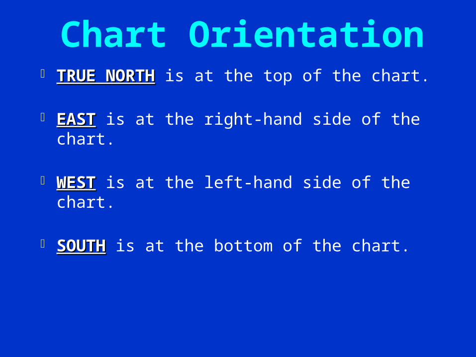
Chart Orientation TRUE NORTHTRUE NORTH is at the top of the chart.
EASTEAST is at the right-hand side of the chart.
WESTWEST is at the left-hand side of the chart.
SOUTHSOUTH is at the bottom of the chart.

New TerminologyNew Terminology Meridians of LongitudeMeridians of Longitude
– Vertical lines on the chart.– Numbered in degrees eastward and
westward from the Prime Meridian located in Greenwich, England.
– Longitude Scales are found at the top and bottom of a nautical chart.
– Distortion occurs as the Meridians approach the poles.
– Always Great Circles.

Parallels of LatitudeParallels of Latitude [ LAT is FLAT]
– The horizontal lines on a Nautical Chart.
– Numbered in degrees north and south of the equator toward the poles.
– Latitude scales are located at the left and right hand sides of the nautical chart.
– One degree of latitude is equal to 60 nm.
One minute of Latitude is equal to one nm.
– Latitude scales are used to measure distance on a nautical chart.

SC - Small Craft ChartSC - Small Craft Chart The Small Craft Chart is the exception
to the rule.
True North orientation is not at the top of this chart.
Use the Compass Rose to orient True North on a SC Chart.

The Compass RoseThe Compass Rose Every chart has a least one Compass
Rose.
The star on the Compass Rose points to True North.
The outer circle projects True North,
The inner circle projects Magnetic North.

VARIATION
ERROR
TRUE
NORTH
MAGNETIC
NORTH
COMPASS ROSE

Magnetic North is 016 degrees016 degrees to the West West
in the Boston area. The difference between True and Magnetic
North is called Variation ErrorVariation Error.. Variation ErrorVariation Error is printed in the center of
the Compass Rose. By using the latest charts, you will always
have the latest up-to-date variation references.
Many newer GPS sets automatically adjust for Variation Error. Check your GPS manual!

Chart NumberChart Number Located at the bottom left-hand corner of a
nautical chart.
Chart Number is the official document number for the chart.
Edition Number is also shown.
Date of last Update indicates the last time that the chart was updated was 10:00 AM on this date.

Chart Number and Revision Date

The Coast Guard publishes data for
correcting nautical charts in a free publication called the:LNM - Local Notice to Mariners.
The LNM Internet Address is:
www.navcen.uscg.mil Always use the latest edition charts
for the greatest safety.

General Information General Information BlockBlock
1. The NameName reflects the body of water covered by the chart.
2.2. Vertical DatumVertical Datum - definition of how depths are measured on the chart.
Feet, Meters, or Fathoms (6 feet).
Calibrate your depth sounder to this Datum.

General
Information
Block
1. Name2. Vertical Datum - Depth

MLW - Mean Low WaterMean Low Water - is the
mean or average of the all of the low tide projections for the area.
– Boston has two low tides per day.
MLLW - Mean Lower Low WaterMean Lower Low Water is the mean or average of the lowest tide projections for the area.
– The lowest of the lows.– All charts are being changed to this
datum.

Cautionary Notes A “Mean” is an average. Therefore,
depths can be higher or lower than the printed depth shown on a nautical chart.
Depths are also affected by storms, the moon, and shoaling in the area.
– Onshore winds can increase the depth of water.
– Offshore winds can decrease the depth of water and/or delay its predicted depth time.

Depths found on nautical charts are best professional guesses.
Always use two methods for determining water depth.– A charted depth and a depth sounder are
acceptable as long as the depth sounder is set to the vertical datum from the chart that you are using.
Before you start out on a trip, always calibrate (verify) the accuracy of your depth sounder.

3.3.Scale of the ChartScale of the Chart - - a ratio of inches on the
chart to inches on the earth’s surface.
– 1:40,000 means that 1 inch on the chart represents 40,000 inches on the earth’s surface.
4.4.Heights of ObjectsHeights of Objects are measured in vertical datum above Mean High Water.
– Clearance under bridges are measured up from the MHW projection.
– Heights of lights are measured up from the MHW projection to the focal plane of the light.

Special Abbreviations and NotesSpecial Abbreviations and Notes are
shown that are peculiar to the area.
Cautionary NotesCautionary Notes - special notes of
uncharted dangers in the area. Special Tide and Current InformationSpecial Tide and Current Information -
any unique tide or current phenomena in the area is noted.
Magnetic InterferenceMagnetic Interference in the area. LORAN InterferenceLORAN Interference in the area.
Anchorage AreasAnchorage Areas in the area.

Soundings and Water DepthSoundings and Water Depth
Depth designations are shown with:– Numbers which reflect the vertical
sounding datum.– Colors - shallow water is tinted a darker
blue and deeper water is a lighter blue and white.
– Contour Lines - a system of standardized symbols and abbreviations - dots and dashes.

Depths are expressed in:
– Feet.– Meters.– Fathoms [Six Feet per Fathom]
All depths refer to the vertical datum of the chart.

Main DredgedChannel
Red
right
returning
from
the
sea

353o True
ColregsDemarcation
Line
Lighthouse
30 foot line
Scale
1:12,000
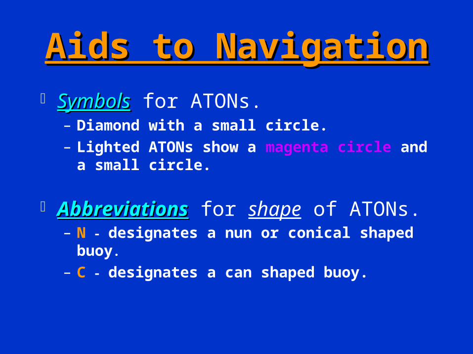
Aids to NavigationAids to Navigation SymbolsSymbols for ATONs.
– Diamond with a small circle.– Lighted ATONs show a magenta circle and a
small circle.
AbbreviationsAbbreviations for shape of ATONs.– N - designates a nun or conical shaped buoy.
– C - designates a can shaped buoy.

Abbreviations that indicate color of
the ATON.R - Red - Diamond symbol will be printed
red.G - Green - Diamond symbol will be
printed green. RRWW - Red and White..GR - Green buoy with Red band.RG - Red buoy with Green band.Y - Yellow - When ATON is painted white
or yellow, the diamond chart symbol is left white or blank.

Abbreviations for Light color on Buoys:
– R - Light is Red.
– G - Light is Green.
– Y - Light is Yellow.
– When no color symbol is shown with a buoy, the light color is assumed to be white.
Other Features on Buoys:
– Sound Signals - Horns, whistles, bells, and gongs.
– RADAR Reflectors - reference is found only in the Light List.

– Numbers - Nuns are even numbered and cans are odd numbered.
– Letters - Used on non-lateral buoys.
– Light Flash Characteristics - how the light flashes.
Note: The numbers or letters, and the flashing characteristics on the Aid are printed on the
nautical chart beside the chart symbol.


Symbols for Light Houses and
Other Fixed Aids.
–Major Lights - Light Houses. Black Dot with a Flare - looks like an
exclamation point. Name of Light appears on the Chart. Shows height and range of light.
–Small Lights - Fixed Lights. Black Dot with a Flare - looks like an
exclamation point. Not named on the chart. Will show height and range.

Portland Head
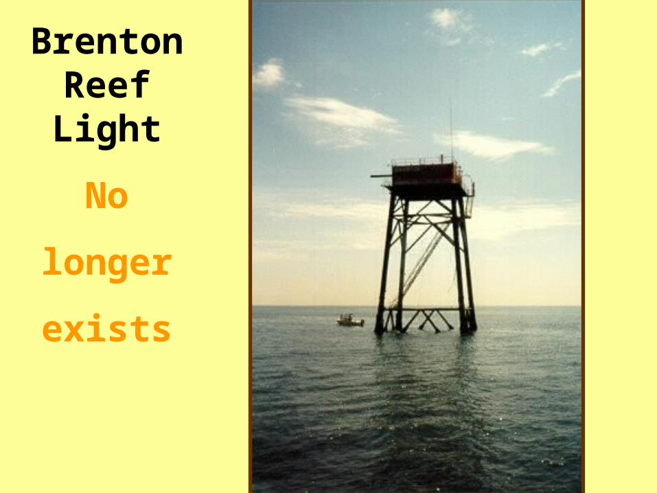
Brenton Reef Light
No
longer
exists

Ranges:
– Consist of two daymarks or beacons.– Shows a dashed line in the direction of the
range or safe water.– If not lighted, shows daymark symbols as
squares or triangles.– Interpretation of panel colors is found in the
front of the Light List.– If lighted, light symbols and flash
characteristic appears on the chart.
CAUTIONARY NOTE: Ranges are usually fixed on land, rocks, or shoals. Always use a nautical chart when transiting a range.

RANGE

Shelter Island Range, San Diego
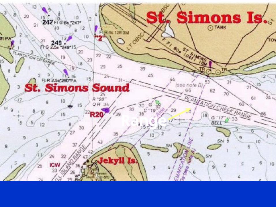
Range

Isolated Danger Marks
– Erected on or moored over a danger.– Horizontal bands of red and black.– White light.– Top mark of two black spheres.– Chart symbol has two black dots over
the diamond symbol.

Daymarks - Day Beacons
– Permanently fixed structures.– Uses square, octagonal or triangle panels to
designate their use.
– TR and small triangle. Red - Even numbered - Red light if lighted. Treat as if a nun buoy
– SQ and small square. Green - Odd numbered - Green light if
lighted.
CAUTIONARY NOTE: Do not pass close aboard (near) daymarks due to the danger of striking their foundation.

Other Charted Features
Prominent Landmarks– Water towers, smoke stacks, church
spires, flag poles, public buildings.– Symbol is a circle with a dot indicating a
highly surveyed position.– Great for taking bearings.– Circle symbol without a center dot is an
approximate position.– Landmarks on private property are not
plotted on nautical charts.

Wrecks, Rocks and Reefs.
– May be shown as: Symbol Abbreviation plus a number. Dashed or dotted line around a symbol.
Bottom characteristics– Symbol or abbreviation used alone or in
combination.
Structures– Jetties, docks drawbridges, and ramps.– Some docks do not appear on a chart
depending on the scale of the chart.

ROCKs and Obstructions

BRIDGES


Coastlines– Identified at both high and low water.– Any prominent landmarks that may help you
get a fix on your position may be shown.– Any details located a short distance from the
shore line may not be shown.
Lettering on a Nautical Chart.– Vertical lettering indicates fixed objects.– Slanted lettering indicates floating objects.

Horizontal Datum Accuracy is based on the survey that was made
to generate the chart.– NAD27– NAD83
WGS84 Has accuracy impact between your GPS Set and the
nautical chart..
Your GPS set must be adjusted to reflect
the datum of the Nautical Chart that you
are using.

Criteria used to determine the accuracy of
a nautical chart..
– Source and date of the survey.
– Amount of detail of the soundings in an area.
– Blank spaces should be regarded with suspicion.
– The term, “Dumping Ground”, indicates that material was dumped in the area and that soundings in this area have not been verified.
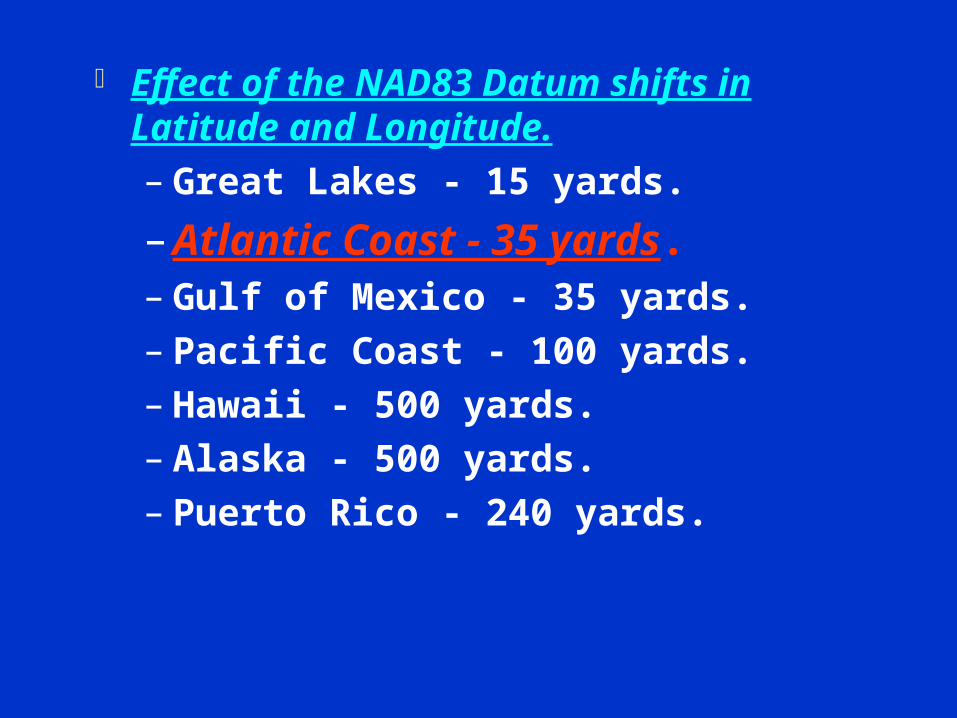
Effect of the NAD83 Datum shifts in Latitude and Longitude.– Great Lakes - 15 yards.
– Atlantic Coast - 35 yards.– Gulf of Mexico - 35 yards.– Pacific Coast - 100 yards.– Hawaii - 500 yards.– Alaska - 500 yards.– Puerto Rico - 240 yards.

Any Questions? Mercator Projection Small Craft Chart Compass Rose General Information Block Mean Lower Low Water. Vertical Datum – Depth. Horizontal Datum – Area.

Electronic Equipment Notes
Set your Depth Sounder to the vertical datum from your chart—feet, meters, or fathoms.
Set your GPS to the horizontal datum from your chart--WGS 84.
If your GPS or LORAN does not have an automatic variation adjustment, set it for the Variation Error found in the nearest Compass Rose.

Traffic Separation Scheme


Any questions about:
AV Task 1-3 Making LNM
corrections to a nautical chart – page 117