sesa 11 sur ridge 20160503 - microsoft · onofre ja. 1999. analysis and modeling of the acoustic...
TRANSCRIPT

Updated: 5/3/2016 For more information -‐ http://montereybay.noaa.gov/resourcepro/ebmi/sesa.html
1
Description SESA 11 includes a large rocky feature, Sur Ridge, and the surrounding area on
Sur Slope. Though it includes a wide depth range (817-1,569 m), this SESA has low habitat richness (2 habitats) and habitat diversity (index =1.56) because it
includes hard (16%) and soft substrate in only one depth zone (slope 2). Recent
cruise research expeditions have contributed to geologic and oceanographic
surveys, and biological characterization. Groundfish trawl surveys on the soft bottom surrounding Sur Ridge have captured a few structure-forming
invertebrates (sea pen, gorgonians, black and soft corals) and a fish fauna of
intermediate richness (mean=13.5 species) and diversity (mean index=1.53). Water upwelled at Point Sur is likely to be advected through this SESA. The
water over this SESA has relatively low primary productivity and has low
likelihood of being a krill hot spot. The eastern side of the SESA is part of a
marine mammal foraging hotspot. This SESA is located within MBNMS, and research activities may require a permit (http://montereybay.noaa.gov/resourcepro/permit/permits_need.html).
Resource Management Issues
Commercial and recreational human activities can be
beneficial or harmful depending on rate and disturbance
type, e.g., benthic trawling, vessel traffic, dredging.
• NPS cable • Commercial bottom trawling • Essential Fish Habitat (EFH) Conservation Area • Commercial shipping lane • Recreational fishing • Wildlife viewing • Coral restoration • EFH bottom trawl closure proposed (2013) • Leatherback sea turtle critical habitat • Ocean acidification
Figure 2. Close-up map of SESA 11. Grey=SESA boundary; orange=EFH Conservation Area; red=Dominant commercial shipping lane. Source: SESAs Interactive Map, http://sanctuarymonitoring.org/maps/sesa/.
Sanctuary Ecologically Significant Area (SESA) SESA 11: Sur Ridge
Figure 1. The location of SESA 11 and twelve additional SESAs in Monterey Bay National Marine Sanctuary. Credit: Chad King/MBNMS.

Updated: 5/3/2016 For more information -‐ http://montereybay.noaa.gov/resourcepro/ebmi/sesa.html
2
Living Marine Resources & Uses
Table 1. Species known to occur within SESA 11: Sur Ridge Invertebrates -sponges† (Porifera)
-black corals† (Antipatharia) -stony corals† (Scleractinia) -soft corals† (gorgonians), e.g., bubble gum and bamboo -sea pens† (Pennatulacea), e.g., Virgulariidae, Anthoptilidae -sea slugs (Nudibranchia) -cold seep clams (Vesicomyid) -octopi (Cephalopoda) -red galatheid crabs, squat lobsters (Galatheidae) -sea stars (Asteroidea) -brittle stars (Ophiuroidea) -deep-sea fragile urchin (Strongylocentrotus fragilis) (NMFS West Coast Bottom Trawl Groundfish Surveys) For complete list see “Sur Ridge Taxonomic Guide,” Burton and Kuhnz (In Prep.)
Fishes -Shortspine Thornyhead (Sebastolobus alascanus) -Blob Sculpin (Psychrolutes phrictus) For complete list see “Sur Ridge Taxonomic Guide,” Burton and Kuhnz (In Prep.)
Marine birds -Buller’s Shearwater (Puffinus bulleri) -California Brown Pelican (Pelecanus occidentalis californicus) -Western Gull (Larus occidentalis) -Black-legged Kittiwake (Rissa tridactyla) -Common Murre (Uria aalge) -Rhinoceros Auklet (Cerorhinea monocerata) (Ainley et al. 2012)
Marine mammals -blue whale¹ (Balaenoptera musculus) -humpback whale¹ (Megaptera novaeangliae) -dolphins (Odonteceti), e.g., Risso’s dolphin (Grampus griseus), Pacific white-sided dolphin (Lagenorhynchus obliquidens), Dall’s porpoise (Phocoenoides dalli) -Northern elephant seal (Mirounga angustirostris) -sea lions (Otariinae), e.g., Stellar sea lion² (Eumetopias jubatus), California sea lion (Zalophus californianus) (NOAA, 2003)
Marine reptiles -leatherback sea turtle¹ (Dermochelys coriacea) (NOAA, 2003) Special Status Species: Endangered¹, Threatened²; Biogenic habitat† Diverse or productive communities:
• low primary productivity
• marine mammal foraging hotspot
Migration, breeding, or foraging areas:
• Dall’s porpoise, sea lions, dolphins, blue whale, and humpback whale (ESI, Environmental Sensitivity Index)
• 100% in leatherback sea turtle NMFS critical habitat

Updated: 5/3/2016 For more information -‐ http://montereybay.noaa.gov/resourcepro/ebmi/sesa.html
3
Research
SIMoN projects: CSCAPE: Collaborative Survey of Cetacean Abundance and the Pelagic Ecosystem (2005-07)
http://sanctuarysimon.org/projects/100273/cscape%3a--collaborative-survey-of-cetacean-abundance-and-the-pelagic-ecosystem
Sea Turtle Restoration Project: Leatherback Watch Program (2010-current) http://sanctuarymonitoring.org/projects/100395/sea-turtle-restoration-project%3a-leatherback-watch-program-
Structure of Populations, Levels of Abundance and Status of Humpbacks (SPLASH) (2004-current) http://sanctuarymonitoring.org/projects/100224/structure-of-populations%2c-levels-of-abundance-and-status-of-humpbacks-%28splash%29
Tagging of Pacific Predators (TOPP) (2000-current) http://sanctuarymonitoring.org/projects/100137/tagging-of-pacific-predators-%28topp%29
Tracking Black-footed Albatross Movements and Conservation (2004-08) http://sanctuarysimon.org/projects/100305/tracking-black-footed-albatross-movements-and-conservation
Underwater Behavior of Large Whales Using Suction-cup Attached Tags (2000-current) http://sanctuarymonitoring.org/projects/100153/underwater-behavior-of-large-whales-using-suction-cup-attached-tags
usSEABED: A USGS Pacific Coast Offshore Surficial Sediment Data and Mapping Project (2005-current) http://sanctuarymonitoring.org/projects/100247/usseabed%3a-a-usgs-pacific-coast-offshore-surficial-sediment-data-and-mapping-project
Monitoring stations and/or data collection instruments:
• NMFS West Coast Bottom Trawl Groundfish Survey
MBNMS research:
• CTD profile (NOAA Ship Shimada, 2015)
• Mid-water fish trawl (NOAA Ship Shimada, 2015)
• Coral transplant experiments (MBARI, 2015)
• Biological characterization (MBARI ROV surveys, 2013 and 2014)
Science Needs & Research Questions Bottom Trawling: Habitat and Species Recovery
http://sanctuaries.noaa.gov/science/assessment/pdfs/mbnms_extraction_trawling.pdf • Which habitats are sensitive to bottom trawling?
Habitat Characterization of the Continental Slope
http://sanctuaries.noaa.gov/science/assessment/pdfs/mbnms_characterization_slope.pdf • What are the distribution and abundance of organisms and habitats on the continental slope? • How do corals and chemosynthetic communities on the continental slope provide biogenic habitat for other species?
Human Health - Harmful Algal Blooms
http://sanctuaries.noaa.gov/science/assessment/pdfs/mbnms_habs.pdf • How do HABs affect local species populations?
Updated: 5/3/2016 For more information -‐ http://montereybay.noaa.gov/resourcepro/ebmi/sesa.html
4
Impacts on Whales from Human Uses http://sanctuaries.noaa.gov/science/assessment/pdfs/mbnms_whale_science.pdf • What are the spatial and temporal patterns of habitat use of large whales throughout sanctuary waters (both inshore
and offshore)? Socioeconomics and the Human Dimension
http://sanctuaries.noaa.gov/science/assessment/pdfs/mbnms_socioeconomics.pdf • How do we determine the overall impact of multiple human activities (some with negative and some with positive
influence) on Sanctuary resources? Water Quality Integrated Analyses
http://sanctuaries.noaa.gov/science/assessment/pdfs/mbnms_water_quality.pdf • Determine and implement the necessary monitoring to assess the condition of water quality in the Sanctuary.
Updated: 5/3/2016 For more information -‐ http://montereybay.noaa.gov/resourcepro/ebmi/sesa.html
5
SESAs Interactive Map: http://sanctuarysimon.org/maps/sesa
Publically Available Imagery
• SIMoN Photo Library (http://sanctuarysimon.org/photos/index.php)
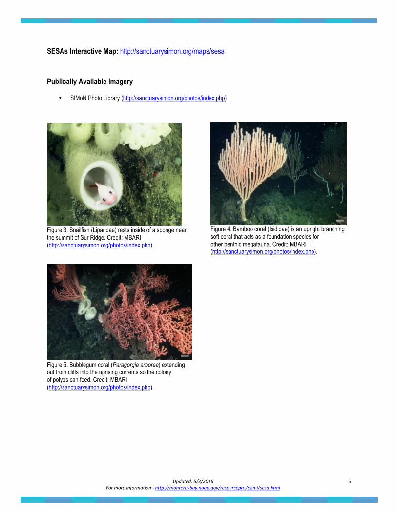
Figure 3. Snailfish (Liparidae) rests inside of a sponge near the summit of Sur Ridge. Credit: MBARI (http://sanctuarysimon.org/photos/index.php).
Figure 5. Bubblegum coral (Paragorgia arborea) extending out from cliffs into the uprising currents so the colony of polyps can feed. Credit: MBARI (http://sanctuarysimon.org/photos/index.php).
Figure 4. Bamboo coral (Isididae) is an upright branching soft coral that acts as a foundation species for other benthic megafauna. Credit: MBARI (http://sanctuarysimon.org/photos/index.php).
Updated: 5/3/2016 For more information -‐ http://montereybay.noaa.gov/resourcepro/ebmi/sesa.html
6
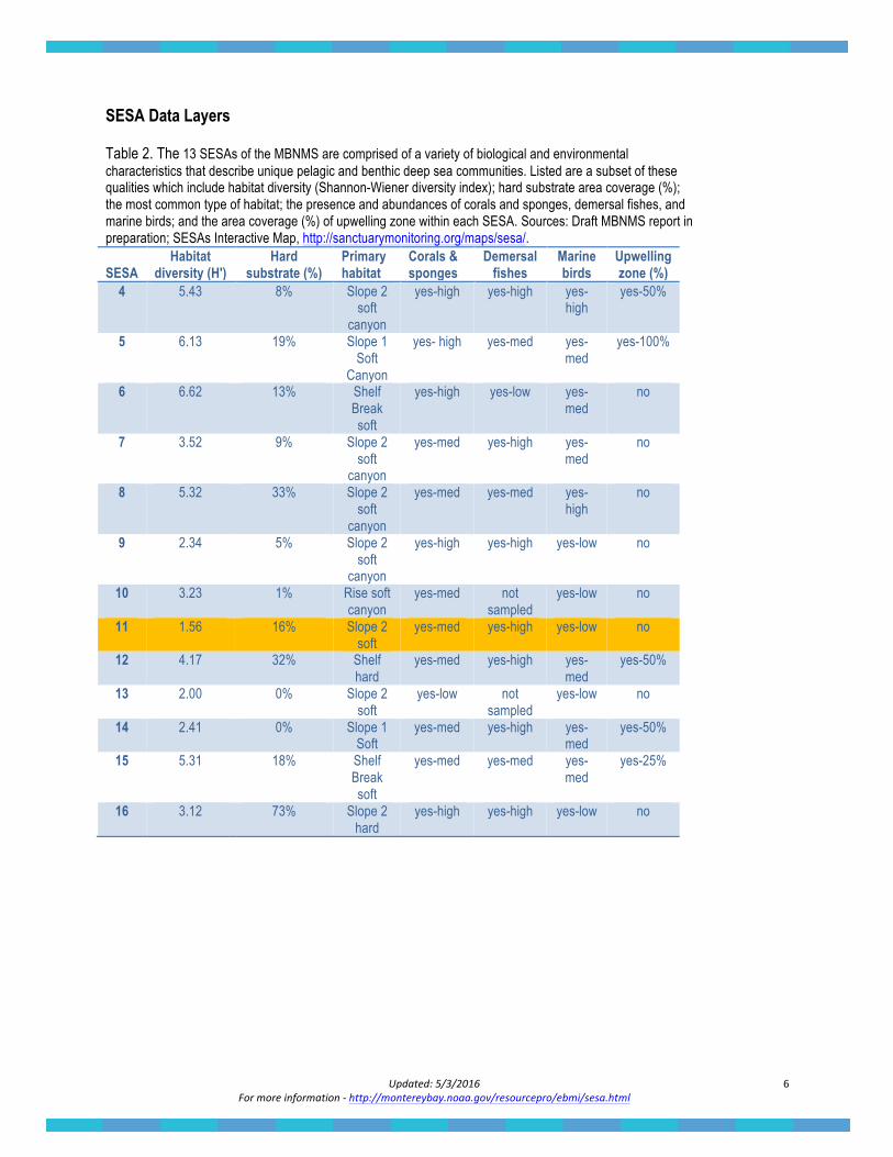
SESA Data Layers Table 2. The 13 SESAs of the MBNMS are comprised of a variety of biological and environmental characteristics that describe unique pelagic and benthic deep sea communities. Listed are a subset of these qualities which include habitat diversity (Shannon-Wiener diversity index); hard substrate area coverage (%); the most common type of habitat; the presence and abundances of corals and sponges, demersal fishes, and marine birds; and the area coverage (%) of upwelling zone within each SESA. Sources: Draft MBNMS report in preparation; SESAs Interactive Map, http://sanctuarymonitoring.org/maps/sesa/. SESA
Habitat diversity (H')
Hard substrate (%)
Primary habitat
Corals & sponges
Demersal fishes
Marine birds
Upwelling zone (%)
4 5.43 8% Slope 2 soft
canyon
yes-high yes-high yes-high
yes-50%
5 6.13 19% Slope 1 Soft
Canyon
yes- high yes-med yes-med
yes-100%
6 6.62 13% Shelf Break soft
yes-high yes-low yes-med
no
7 3.52 9% Slope 2 soft
canyon
yes-med yes-high yes-med
no
8 5.32 33% Slope 2 soft
canyon
yes-med yes-med yes-high
no
9 2.34 5% Slope 2 soft
canyon
yes-high yes-high yes-low no
10 3.23 1% Rise soft canyon
yes-med not sampled
yes-low no
11 1.56 16% Slope 2 soft
yes-med yes-high yes-low no
12 4.17 32% Shelf hard
yes-med yes-high yes-med
yes-50%
13 2.00 0% Slope 2 soft
yes-low not sampled
yes-low no
14 2.41 0% Slope 1 Soft
yes-med yes-high yes-med
yes-50%
15 5.31 18% Shelf Break soft
yes-med yes-med yes-med
yes-25%
16 3.12 73% Slope 2 hard
yes-high yes-high yes-low no
Updated: 5/3/2016 For more information -‐ http://montereybay.noaa.gov/resourcepro/ebmi/sesa.html
7
Selected Publications
Ainley D, Spear L, Casey J, Ford RG, Gill T, et al. 2012. Chapter 3: Biogeography of Marine Birds. A Biogeographic Assessment off North/Central California. Retrieved from Center for Coastal Monitoring and Assessment (NCCOS), National Ocean Service. http://ccma.nos.noaa.gov/ecosystems/sanctuaries/california/html/birds/ Andrew RK, Howe BM, Mercer JA. 2002. Ocean Ambient Sound: Comparing the 1960s with the 1990s for a receiver off the California Coast. Acoustics Research Letters Online 3:65-70, doi:10.1121/1.1461915. Benson SR, Forney KA, Harvey JT, Carretta JV, Dutton PH. 2007. Abundance, Distribution, and Habitat of Leatherback Turtles (Dermochelys coriacea) Off California, 1990− 2003. Fishery Bulletin, 105(3): 337-347. Available at: http://aquaticcommons.org/8876/1/benson_Fish_Bull_2007.pdf http://montereybay.noaa.gov/research/techreports/trbenson2007.html. Brown JA, EJ Burton, S De Beukelaer. 2013. The Natural Resources of Monterey Bay National Marine Sanctuary: A Focus on Federal Waters. Marine Sanctuaries Conservation Series ONMS-13-05. U.S. Department of Commerce, National Oceanic and Atmospheric Administration, Office of National Marine Sanctuaries, Silver Spring, MD. 264 pp. Available at: http://montereybay.noaa.gov/research/techreports/trbrown2013.html Greene HG, Maher NM, Paull CK. 2002. Physiography of the Monterey Bay National Marine Sanctuary and Implications About Continental Margin Development. Marine Geology, 181(1-3): 55-82. Hall RA, Glenn SC. 2011. Internal Tides in Monterey Submarine Canyon. Journal of Physical Oceanography, 41(1): 186-204. Harvey JT, Raum-Suryan KL, Suryan RM. 1996. Distribution and Abundance of Marine Mammals Near Sur Ridge, California, The Former Proposed Site of the Acoustic Thermometry of Ocean Climate (ATOC) Sound Source (96-2). Moss Landing Marine Laboratories Technical Publication: 1-37. Neander DO. 2002. Analysis of Temperature Variability Between Davidson Seamount and Sur Ridge: The Tomographic Inverse Problem. Master of Science Thesis. Naval Postgraduate School, Monterey California. 1-59. NOAA National Centers for Coastal Ocean Science (NCCOS). 2003. A Biogeographic Assessment off North/Central California: To Support the Joint Management Plan Review for Cordell Bank, Gulf of the Farallones, and Monterey Bay National Marine Sanctuaries: Phase I - Marine Fishes, Birds and Mammals. Prepared by NCCOS’s Biogeography Team in cooperation with the National Marine Sanctuary Program. Silver Spring, MD 145 pp. Normark WR and Gutmacher CE. 1988. Sur Submarine Slide, Monterey Fan, Central California. Sedimentology, 35(4): 629. Onofre JA. 1999. Analysis and Modeling of the Acoustic Tomography Signal Transmission From Davidson Seamount to Sur Ridge: The Forward Problem. Master of Science Thesis, Naval Postgraduate School, Monterey, California. 1-53. Rago T, Collins CA, Chiu CS, Worcester P, Castro CG. 2000. Oceanographic Data from Sur Ridge (36.3°N, 122.4°W) to Hoke Seamount (32.1°N, 126.9°W), May 1999. Naval Postgraduate Report. Thompson JB, Mullins HT, Newton CR, Vercoutere TL. 1985. Alternative Biofacies Model for Dysaerobic Communities. Lethaia 18(2): 167-179. Tseng YH and Breaker LC. 2007. Nonhydrostatic Simulations of the Regional Circulation in the Monterey Bay Area. Journal of Geophysical Research 112, C12017, doi:10.1029/2007JC004093. Tseng YH, Dietrich DE, and Ferziger JH. 2005. Regional Circulation in the Monterey Bay Region: Hydrostatic Versus Nonhydrostatic Modeling. Journal of Geophysical Research 110, C09015, doi:10.1029/2003JC002153. Watters DL, Yoklavich MM, Love MS, Schroeder DM. 2010. Assessing Marine Debris in Deep Seafloor Habitats off California. Marine Pollution Bulletin, 60(1), 131-138.