september 2006 41 · l g fth cone r peak-hour curbside ... • sidewalks here are narrower than on...
TRANSCRIPT
September 2006
Eastern Parkway Extension Master Plan
41
YAWDAORB
TS YAWNOC
TC E
KOOC
TXE YWKP NRETSAE
DVLB DNALHGIH
YW
KP H
GU
OR
OB
RETNI
TS TRAWETS
TS REEVREDNAV
TS REEVREDNAV
VA
AM
AB
ALA
VA CITNALTA
TS D
ROF
DARB
YAWDAORB
VA KCIWHSUBTS YAWNOC
VA YBSORC
FAN
CH
ON
PL
TS NOTLUF
TS NOTLUF
VA
AIG
ROE
G
TS XIR
DNEH
TS REMIKREH
DVLB DNALHGIH
TS E
LA
DSNI
H
YWKP OROBRETNI
INTE
RB
OR
O P
KW
Y
VA ACIAMAJ
VA ACIAMAJ
VA ACIAMAJ
MA
RG
INA
L ST
W
VA RE
LLIM
VA R
ELLI
M
VA Y
ESRE
J WE
N
VA A
INAV
LYS
NNEP
VA D
LEIF
FEHS
VA
REKI
DENS
VA EDISYNNUS
VA N
ELCI
S NA
V
VAN
SIN
DER
EN A
V TS T
NO
MRE
V
VA
SM
AILL
IW
WIL
LIA
MS
PL
TS
ANOY
W
BU
FFA
LO A
V
BU
FFA
LO A
V
VA KROY WEN E
YWKP NRETSAE YWKP NRETSAE
LP NLOCNIL
LP KRAP
TS L
ATR
OP
RA
LPH
AV
RO
CH
ESTE
R A
V
RO
CH
ESTE
R A
V
LP SNHOJ .TS
LP GNILRETS
TS NOINU
RO
CH
ESTE
R A
V
TS Y
OB
MA
VA CITNALTA
TS NEGREB
YAWDAORB
TS NAED
TS HT8
9 E
TS HT8
9 E
VA KROY WEN E
VA KROY WEN E
YWKP NRETSAE
YWKP NRETSAE
TS NOTLUF
TS
NOT
FAR
G
HA
VENS PL
TS REMIKREH
TS L
ZREH
HO
PKIN
SON
AV
VA D
RAW
OH
JAR
DIN
E PL
TS S
UIN
UJ
TS
NOI
GEL
LP NLOCNIL
LP
OC
AN
OM
DVL
B N
OTS
AG
REHT
OM
MO
THER
GA
STON
BLVD
TS CIFICAP
LP KRAP
LP KRAP
VA NIKTIPVA NIKTIP
PLEASA
NT PL
TS L
LEW
OP
LP TCEPSORP
VA H
PLAR
TS
NA
MKC
ASTS
N
AM
KC
AS
SAC
KM
AN
ST
VA A
GOT
ARAS
SAR
ATO
GA
AV
SHER
LOC
K PL
TS SREMOS
LP SNHOJ .TS
VA S'KRAM .TS
LP GNILRETS
LP GNILRETS
TS S
SU
ART
S
TS T
TO
CSP
AT
TS NOTXURT
TS
NOI
NU
VA KROY WEN E
TAPSC
OTT A
VTA
PSCO
TT AV
RA
LPH
AV
YAWKRAP NRETSAE
EU
NEVA
OLAFF
UB
EU
NEVA
HPLA
R
EUNEVA KROY WEN TSAE
EUNEVA YTREBIL
TEERTS CIFICAP
TEERTS NEGREB
EUNEVA SKRAM.TS
EUNEVA CITNALTA
YAWKRAP NRETSAE
SNEERGREVE EHT FO YRETEMEC
yltcerid stcennoc eunevA relliM dna draveluoB dnalhgiH htiw
peets si tub ,kraP dnalhgiH
gnitixe morf ciffart gnigreM-tsew timrep ton seod yawkrap
ot eunitnoc ot stsilcyc dnuob.eunevA kciwhsuB
rodirroc tnedicca-hgiH
nahallaC ot tnecajda etuoRdnuorgyalp ylleK dna
yawkraP nretsaE dna eunevA citnaltAnoitcesretni tluciffid ,tnediccA hgiH
gnola yrtemoeg noitcesretni ralugerrIrenroc eht fo htgnel eht
edisbruc ruoh-kaePenal gnivom
rodirroc tnedicca-hgiH
thgil yrev htiw sklawedis ediWciffart nairtsedep
yawkraP nretsaE cimim snaideMyawneerg rof worran oot tub
on htiw ciffart ralucihev yvaeHdebdaor ssecxe
gnola yrtemoeg noitcesretni ralugerrIrenroc eht fo htgnel eht
yltcerid stcennoc eunevA relliM dna draveluoB dnalhgiH htiw
peets si tub ,kraP dnalhgiH
gnitixe morf ciffart gnigreM-tsew timrep ton seod yawkrap
ot eunitnoc ot stsilcyc dnuob.eunevA kciwhsuB
rodirroc tnedicca-hgiH
nahallaC ot tnecajda etuoRdnuorgyalp ylleK dna
yawkraP nretsaE dna eunevA citnaltAnoitcesretni tluciffid ,tnediccA hgiH
gnola yrtemoeg noitcesretni ralugerrIrenroc eht fo htgnel eht
edisbruc ruoh-kaePenal gnivom
rodirroc tnedicca-hgiH
thgil yrev htiw sklawedis ediWciffart nairtsedep
yawkraP nretsaE cimim snaideMyawneerg rof worran oot tub
on htiw ciffart ralucihev yvaeHdebdaor ssecxe
KRAP DNALHGIH
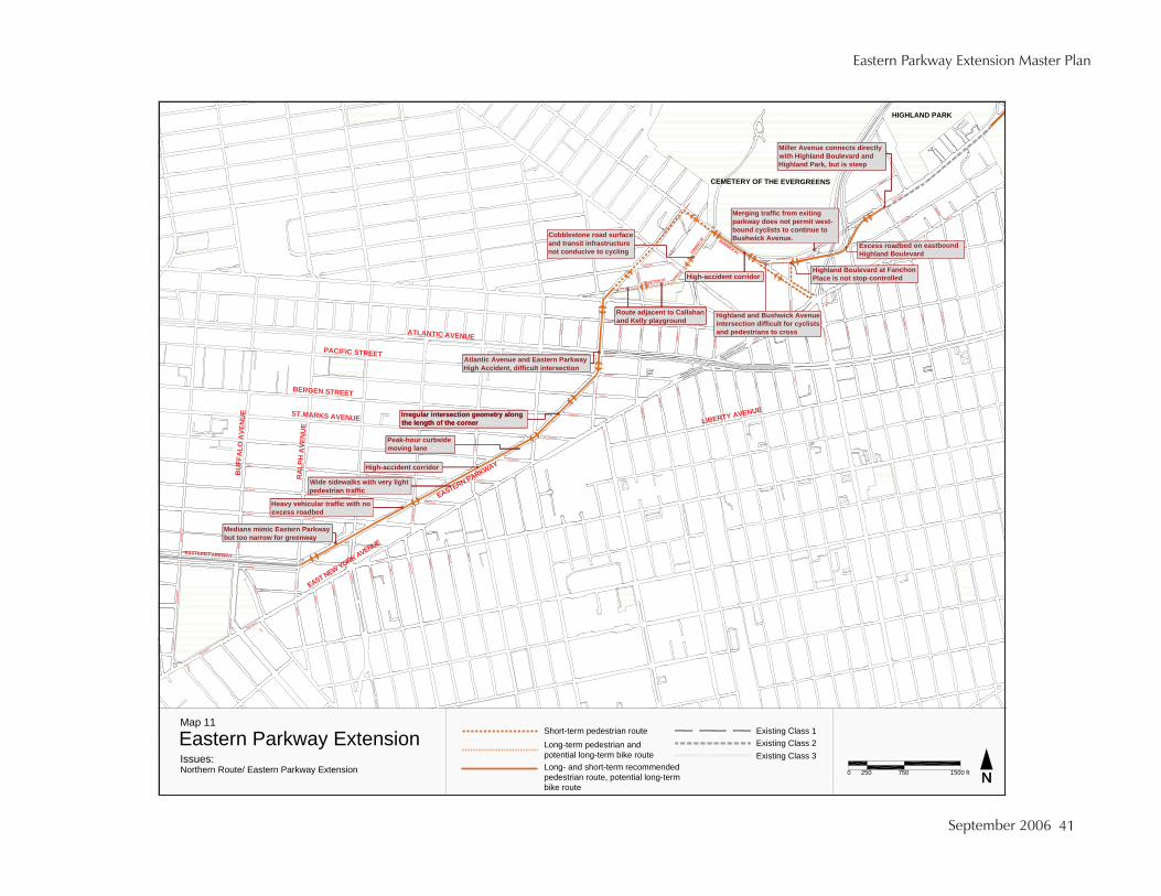
11 paM
noisnetxE yawkraP nretsaE
NN0 052 tf 0051noisnetxE yawkraP nretsaE /etuoR nrehtroN :seussI
057
1 ssalC gnitsixE2 ssalC gnitsixE3 ssalC gnitsixE
Long- and short-term recommended pedestrian route, potential long-term bike route
Long-term pedestrian and potential long-term bike route
Short-term pedestrian route
ecafrus daor enotselbboCerutcurtsarfni tisnart dnagnilcyc ot evicudnoc ton
eunevA kciwhsuB dna dnalhgiHstsilcyc rof tluciffid noitcesretni
ssorc ot snairtsedep dna
Highland Boulevard at Fanchon Place is not stop-controlled
Excess roadbed on eastbound Highland Boulevard

New York City Department of City Planning: Transportation Division, New York City Department of Parks & Recreation
The Brooklyn-Queens Greenway
42
Mark high-visibility crosswalksHigh-visibility crosswalks should be striped at all intersections along the route. These crosswalks provide greater safety for pedestrians.
Mark advanced stop linesStop lines should be striped three to four feet from the crosswalk at all signalized intersections along Eastern Parkway Extension.
Install greenway signsStandard greenway signs should be installed to identify the route and to separate non-motorized users on the sidewalk.
Eastern Parkway Extension to Highland Boulevard, short-term routeExisting ConditionsWe propose alternate routes for the greenway in the long- and the short-term. In the short-term we recommend that pedestrians continue north on Eastern Parkway Extension to Mother Gaston Boulevard and then to Vanderveer Street. They should then turn to walk down the southern sidewalk of Bushwick Avenue, continue on that to East New York Avenue where they should cross Bushwick Avenue, backtrack to Fanchon Place, walk north on Fanchon Place and there connect with the long-term recommended route, discussed in the rest of the Recommended Northern Route.
Mother Gaston Boulevard, Vanderveer Street, and Bushwick Avenue are all relatively industrial in character, with an auto service station on the southeast corner of Bushwick Avenue and Vanderveer Street. The route has the advantage, though, of having signalized crossings for pedestrians.
Findings• Land use is primarily industrial along Vanderveer Street and Bushwick Avenue.• There are signalized or stop-controlled crossings for pedestrians at all intersections.
Recommendations [Map 11]Mark high-visibility crosswalks
High-visibility crosswalks should be striped at all intersections along the route. These crosswalks provide greater safety for pedestrians.
Truxton Street and Conway Street from Eastern Parkway Extension to Bushwick AvenueExisting ConditionsIn the long-term we recommend seeking ways to allow pedestrians and eventually cyclists to connect with the route discussed in this paragraph and in the rest of the chapter on the Recommended Northern Route. The route leaves Eastern Parkway Extension at two-way
September 2006
Eastern Parkway Extension Master Plan
43
Truxton Street. On the south side of the street is Callahan and Kelly Playground, a grassy area with benches, a baseball field, and basketball courts that is shared by the community and Public School 255. One-story residential buildings and a large parking lot line the north side of the street opposite the park. Truxton Street is 38 feet wide. The street has an eight-foot parking lane and an 11-foot travel lane in each direction. Vehicular traffic is light. Westbound traffic must turn right on Eastern Parkway Extension due to the continuation of the median through the intersection.
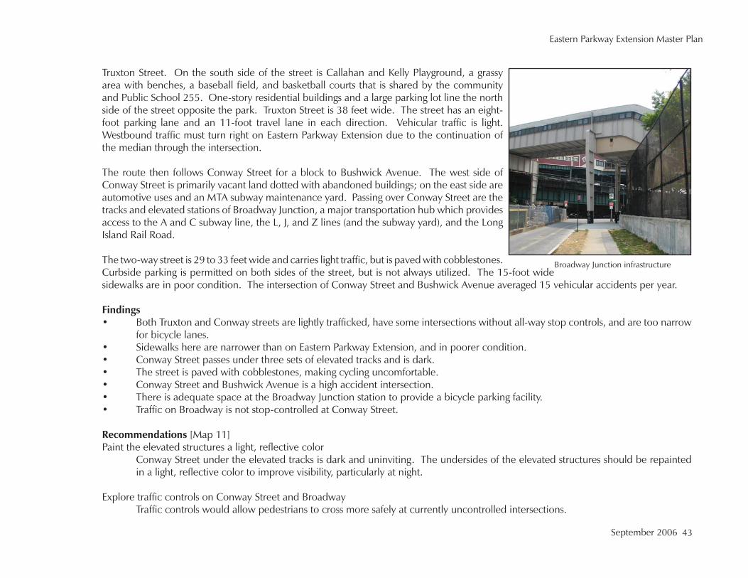
The route then follows Conway Street for a block to Bushwick Avenue. The west side of Conway Street is primarily vacant land dotted with abandoned buildings; on the east side are automotive uses and an MTA subway maintenance yard. Passing over Conway Street are the tracks and elevated stations of Broadway Junction, a major transportation hub which provides access to the A and C subway line, the L, J, and Z lines (and the subway yard), and the Long Island Rail Road.
The two-way street is 29 to 33 feet wide and carries light traffic, but is paved with cobblestones. Curbside parking is permitted on both sides of the street, but is not always utilized. The 15-foot wide sidewalks are in poor condition. The intersection of Conway Street and Bushwick Avenue averaged 15 vehicular accidents per year.
Findings• Both Truxton and Conway streets are lightly trafficked, have some intersections without all-way stop controls, and are too narrow
for bicycle lanes.• Sidewalks here are narrower than on Eastern Parkway Extension, and in poorer condition.• Conway Street passes under three sets of elevated tracks and is dark.• The street is paved with cobblestones, making cycling uncomfortable.• Conway Street and Bushwick Avenue is a high accident intersection.• There is adequate space at the Broadway Junction station to provide a bicycle parking facility.• Traffic on Broadway is not stop-controlled at Conway Street.
Recommendations [Map 11]Paint the elevated structures a light, reflective color
Conway Street under the elevated tracks is dark and uninviting. The undersides of the elevated structures should be repainted in a light, reflective color to improve visibility, particularly at night.
Explore traffic controls on Conway Street and Broadway Traffic controls would allow pedestrians to cross more safely at currently uncontrolled intersections.
Broadway Junction infrastructure
New York City Department of City Planning: Transportation Division, New York City Department of Parks & Recreation
The Brooklyn-Queens Greenway
44
Provide bicycle parking at the Broadway Junction subway stationThe addition of bicycle racks would facilitate intermodal transfers at this transportation hub.
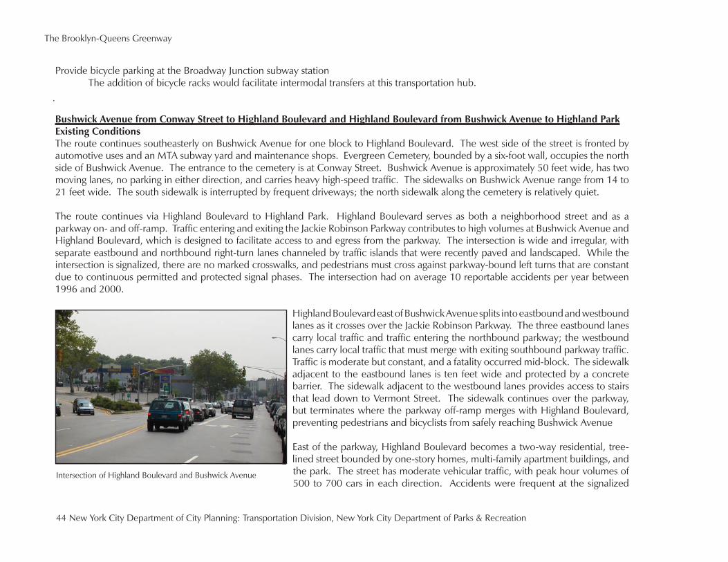
Bushwick Avenue from Conway Street to Highland Boulevard and Highland Boulevard from Bushwick Avenue to Highland ParkExisting ConditionsThe route continues southeasterly on Bushwick Avenue for one block to Highland Boulevard. The west side of the street is fronted by automotive uses and an MTA subway yard and maintenance shops. Evergreen Cemetery, bounded by a six-foot wall, occupies the north side of Bushwick Avenue. The entrance to the cemetery is at Conway Street. Bushwick Avenue is approximately 50 feet wide, has two moving lanes, no parking in either direction, and carries heavy high-speed traffic. The sidewalks on Bushwick Avenue range from 14 to 21 feet wide. The south sidewalk is interrupted by frequent driveways; the north sidewalk along the cemetery is relatively quiet.
The route continues via Highland Boulevard to Highland Park. Highland Boulevard serves as both a neighborhood street and as a parkway on- and off-ramp. Traffic entering and exiting the Jackie Robinson Parkway contributes to high volumes at Bushwick Avenue and Highland Boulevard, which is designed to facilitate access to and egress from the parkway. The intersection is wide and irregular, with separate eastbound and northbound right-turn lanes channeled by traffic islands that were recently paved and landscaped. While the intersection is signalized, there are no marked crosswalks, and pedestrians must cross against parkway-bound left turns that are constant due to continuous permitted and protected signal phases. The intersection had on average 10 reportable accidents per year between 1996 and 2000.
Highland Boulevard east of Bushwick Avenue splits into eastbound and westbound lanes as it crosses over the Jackie Robinson Parkway. The three eastbound lanes carry local traffic and traffic entering the northbound parkway; the westbound lanes carry local traffic that must merge with exiting southbound parkway traffic. Traffic is moderate but constant, and a fatality occurred mid-block. The sidewalk adjacent to the eastbound lanes is ten feet wide and protected by a concrete barrier. The sidewalk adjacent to the westbound lanes provides access to stairs that lead down to Vermont Street. The sidewalk continues over the parkway, but terminates where the parkway off-ramp merges with Highland Boulevard, preventing pedestrians and bicyclists from safely reaching Bushwick Avenue
East of the parkway, Highland Boulevard becomes a two-way residential, tree-lined street bounded by one-story homes, multi-family apartment buildings, and the park. The street has moderate vehicular traffic, with peak hour volumes of 500 to 700 cars in each direction. Accidents were frequent at the signalized
Intersection of Highland Boulevard and Bushwick Avenue

September 2006
Eastern Parkway Extension Master Plan
45
HIGHLAND BLVD
INTE
RBO
RO
UG
H P
KWY
INTERBORO PKWY
INTE
RB
OR
O P
KW
Y
JAMAICA AV
RG
INA
L S
T W
MILLER AV
1
2
5
76
4
3
123
Reconfigure intersection geometry and stripe new multiuse crosswalks 456
7Stripe two-way bike lane with protective bollards
Reconfigure sidewalk for shared use
Reconfigure roadbed to accomodate path
Extend curb to channelize traffic
Move center stripe north
Same as 3Reconfigure intersection geometry and stripe new shared-use crosswalksStripe two-way bike lane with protective bollards
Reconfigure sidewalk for shared use
Reconfigure roadbed to accomodate path
Extend curb to channelize traffic
Move center stripe north
Same as 3
Map 12: Aerial of Highland Boulevard from Bushwick to Miller avenues