seminole survey report - oklahoma historical society · at the time of its reestablishment, the...
TRANSCRIPT

1
SURVEY REPORT
INTENSIVE‐LEVEL SURVEY OF DOWNTOWN SEMINOLE
2014

2
Table of Contents
Acknowledgements……………………………………………………………………………………3
Abstract …………………………………………………………………………………………………….4
Introduction……………………………………………………………………………………………….5
Research Design………………………………………………………………………………………….6
Project Objectives……………………………………………………………………………………….7
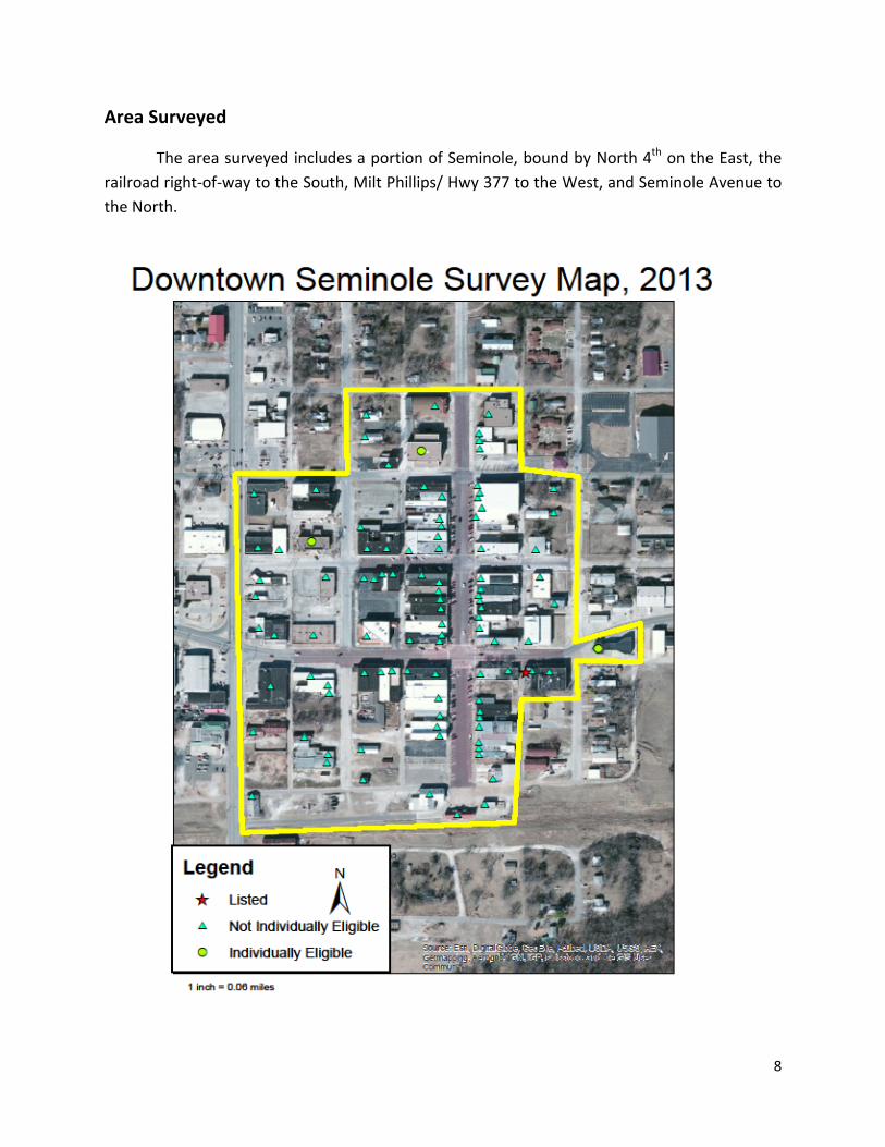
Area Surveyed……………………………………………………………………………………………..8
Methodology………………………………………………………………………………………………10
Results……………………………………………………………………………………………………….11
Types of Properties in the Survey Area……………………………………………………….12
Individual Properties Eligible for the NRHP…………………………………………………13
Historic Context………………………………………………………………………………………...14
Bibliography……………………………………………………………………………………………….21
List of Properties…………………………………………………………………………………………22

3
Acknowledgements
The Intensive‐level survey of downtown Seminole has been funded with Federal funds
from the National Park Service, U.S. Department of the Interior. However, the contents and
opinions do not necessarily reflect the views of or policies of the Department of the Interior.
The Oklahoma State Historic Preservation Office (SHPO) program receives Federal
financial assistance for the identification and protection of historic properties. Under Title VI of
the Civil Rights Acts of 1964, Section 504 of the Rehabilitation Act of 1973, and the Age
Discrimination Act of 1975, as amended, the U.S. Department of the Interior prohibits
discrimination on the basis of race, color, national origin, disability, or age in its federally
assisted programs. If you believe you have been discriminated against in any programs, activity
or facility as described above, or if you desire further information, please write to:
Office of Equal Opportunity
National Park Service
1849 C. Street, NW
Washington, DC 20240
4
Abstract
The Seminole Downtown Survey was conducted to develop an inventory of the buildings
in downtown Seminole. This survey includes evaluation of National Register of Historic Places
eligibility of these buildings. The survey was conducted between March and November of
2013. At total of 101 buildings were surveyed and evaluated. One building the Home Stakes
building is currently listed. Of the 101 buildings surveyed 3 were determined to be individually
eligible for the National Register of Historic Places. The intention of the survey was to
determine if a historic district was present. Due to infill construction, unsympathetic
alterations, and general lack of integrity no historic district was located.

5
Introduction
The Oklahoma State Historic Preservation Office (SHPO) provided the funding for this
intensive‐level survey of Downtown Seminole as an effort to determine the National Register of
Historic Places eligibility the Seminole downtown business district. This survey project began as
a student project; students from the University of Oklahoma’s College of Architecture
completed fieldwork for this survey while earning credit through the Institute for Quality
Communities. Additional fieldwork and the historic context were completed by Meghan Day, as
part of her internship at the OK/SHPO, while earning credit through the Historic Preservation
program at Southeast Missouri State University. The final report and analysis was completed
by Allison Archambo, Survey Coordinator at the Oklahoma State Historic Preservation Office.

6
Research Design
This survey was conducted to determine the eligibility of Downtown Seminole. As with
any serious inquiry into the past and the forces at work in shaping the development of the
world in which we live, including the examination of the historic resources, requires a
systematic effort to assure: (1) conformity to national standards and requirements within the
framework of the National Register of Historic Places, (2) consistency of evaluation, (3)
awareness of historical concepts and contexts appropriate to understanding social changes, and
(4) professional historical research techniques.
Archival research, using primary and secondary sources, developed a historic context for
the survey area and helped to establish dates of construction for individual properties.
Research occurred concurrently with the field survey and data review. This approach allowed
the team to merge the field and research data to create a strong and understandable
relationship between Seminole and its built environment.

7
Project Objectives
The current survey has a variety of uses, but the core objectives shaped the kinds of
information gathered and interpretation of that information for a cultural resources
management‐planning tool.
To identify through an intensive‐level survey if the project area is eligible on the basis of
design and integrity for the National Register of Historic Places.
To record and photograph those individual properties in the project area that, on the
basis of design and integrity, are eligible for listing in the National Register of Historic
Places.
To develop a historic context for the evaluation of Downtown Seminole.
8
Area Surveyed
The area surveyed includes a portion of Seminole, bound by North 4th on the East, the
railroad right‐of‐way to the South, Milt Phillips/ Hwy 377 to the West, and Seminole Avenue to
the North.

9
Area Surveyed

10
Methodology
This project was initiated at the request of the Seminole Main Street coordinator Kiley
Peters in the spring of 2013 in coordination with architecture students in the University of
Oklahoma’s Institute for Quality Communities class taught by Ron Frantz and Hope Mander In
order to prepare the students for survey work Lynda Ozan National Register Coordinator and
Allison Archambo Survey Coordinator from the State Historic Preservation Office worked with
the students on how to collect survey information. The students prepared a first draft of the
survey reports as part of the semester curriculum. Their findings were presented to the State
Historic Preservation Office. In the summer of 2013 Meghan Day an intern from Southeast
Missouri State’s Historic Preservation program worked toward completing the historic context
and preparing the final report during her internship. The final assembly of the report and
completion of the survey forms was done by Allison Archambo.

11
Results
The results of the survey concluded that there was not enough historic integrity present to
support a historic district. Many of the resources in downtown Seminole have experienced
unsympathetic alterations and the area has had several fires in the recent past leaving empty
lots and new construction in place of historic resources. In addition to the previously listed
Home Stake Oil & Gas Company Building at 315 East Broadway, three additional buildings were
determined to be individually eligible for listing on the National Register of Historic Places.
Those buildings are the Union Bus Station, the Municipal Building and the United State Post
Office.

12
Kinds of Historic Properties Present in Survey Area
The Downtown Seminole Survey area had a variety of historical uses with the majority
being commercial. Of the 101 buildings surveyed there were 69 commercial buildings, three
had a business use. Additionally the uses related to the functions of a downtown commercial
district there was the post office, the city hall, fire station, library and a church. Downtown was
also home to regional transportation hubs with the bus station and the rail depot. The
presence of the railroad required warehouses to support the shipment of goods. Also three
hotels and three theaters entertained and housed visitors and locals.
Currently, downtown Seminole supports many of the same functions. There are 50
commercial buildings and seven businesses in the downtown core. Many of the same civic
functions are still taking place in the area. The municipal building, which houses City Hall, and
the United States Post Office are functioning in their historic locations. While there are no
theaters or hotels in downtown today there are three restaurants to serve locals and visitors.
At the time of the survey there were 19 vacant buildings within the survey boundaries.

13
Individual Properties
The Downtown Seminole Survey determined that no historic district is present in downtown
Seminole. Many of the storefronts have been altered with metal, stucco and modern
treatments that compromise their integrity. Additionally downtown Seminole has vacant lots
and new construction in the district which further distract from the overall historic integrity of
the area. The downtown district is home to three buildings that have been determined to be
individually eligible for the National Register of Historic Places.
The United States Post Office at 120 East Oak Avenue: this building was included in the
2004 Survey of New Deal Art and determined to warrant further study for its association
with New Deal Art. The 2014 Survey of Downtown Seminole has determined the
property individually eligible for the National Register of Historic Places under criteria A
for its association with events that have made a significant contribution to the broad
patterns of our history.
The Municipal Building at 401 North Main Street is individually eligible for the National
Register of Historic Places because of the association with the New Deal and is eligible
under criteria A for its association with events that have made a significant contribution
to the broad patterns of our history.
The Union Bus Station at 411 East Broadway Avenue is individually eligible for the
National Register of Historic Places under criteria A for its association with events that
have made a significant contribution to the broad patterns of our history for its
connection to transportation.

14
Historic Context
The search for "black gold" in Oklahoma in the late nineteenth century led to the
eventual discovery of several large oil fields. Some of the most notable were the Cushing,
Glennpool, and the Three Sands pools. However, the most impressive was the Greater
Seminole Oil Field. Although the town of Seminole was not the first in the area to strike oil, it
saw the most oil production, which instantly transformed the small village into a city overnight.
Despite the decline in production of oil in Oklahoma over the last few decades, Seminole is the
one "boom" town that has maintained itself and remains the largest city within the region.
Seminole’s beginnings date back to 1893 with the small village of Tidmore, named after
Joe Tidmore, the missionary contractor for the Mekasukey Indian Mission. The Seminoles
established the Mekasukey Academy for boys (National Register of Historic Places, NR
74001668), and Tidmore developed nearby, consisting of small businesses. However, because
whites in the area were unable to buy Indian land at that time, the village saw little
development.1
The Chicago, Oklahoma, and Gulf Railroad built a line in 1895 that ran through the
Seminole Nation, passing by what is present day Seminole. Due to the muddy terrain
surrounding the location of Tidmore, and its close proximity to the next town of Earlsboro, the
railroad lines considered its location to be undesirable for building. In order to take advantage
1 Morris, Elsie. “Seminole,” Encyclopedia of Oklahoma History and Culture, accessed June 11, 2013, http://digital.library.okstate.edu/encyclopedia/entries/S/SE012.html; Morris, John W., Willa Mae Townes, and Louise Welsh. A History of the Greater Seminole Oil Fields. Oklahoma City: Oklahoma Heritage Association, 1981, p. 69; Ruth, Kent. National Register of Historic Places Nomination Form: Mekasukey Academy, March 28, 1974. SHPO Oklahoma Landmarks Inventory.

15
of the railroad system, in 1906 the town moved a few miles west to what is now the present
location of Seminole. Approximately 12 miles west of Wewoka, and 17 miles east of Shawnee,
the town settled in the center of the Seminole Nation. The town's buildings were carried on
sleds and relocated in what is currently the center of the town of Seminole. The first three
significant institutions to move to Seminole were a bank, general store, and a pool hall.
Seminole was largely an agricultural town, with rich soil for producing crops such as cotton,
corn, potatoes, and kaffir corn. At the time of its reestablishment, the population of Seminole
was 207. The expectation was for it to remain a small, quiet agricultural town, and saw very
little growth for the next two decades.2
It was one of Seminole's own citizens, O. D. Strother, who greatly influenced the
discovery of oil in the Seminole area. In 1892, Strother had studied a United States Geological
Survey map, which reported a line that stretched from Pennsylvania down to Texas. The line
passed through Range 7 through the Seminole Nation, and Strother highly believed that the
area had great potential for producing mass amounts of oil. Strother moved to Tidmore in
1905, working as a shoe salesman. Over time, he purchased land allotments after Congress
lifted the restrictions on sale of the Seminole Indian Lands, acquiring 5,500 acres by 1917. In
addition, he hired a geologist and promoted his land to oil companies, drilling companies, and
petroleum brokers.3
2 Morris, Elsie, “Seminole”; Morris, Townes, and Welsh, Greater Seminole Oil Field, p. 69. 3 Hettich, Judy. National Register of Historic Places Nomination Form: Home Stake Oil and Gas Company, May 14, 1986. SHPO Oklahoma Landmarks Inventory; Morris, Townes, and Welsh, Greater Seminole Oil Field, p. 6‐7.
16
Strother also established the Home Stake Oil and Gas Company (NR 86001094) in 1917.
The company sold shares to help pay interest on the money he borrowed and to pay property
taxes, as well as the acquisition of more land. Company crews began drilling in the early 1920s,
but were initially unsuccessful. It was not until after Strother's death in 1926 that the company
was able to tap the oil. He left the company to his son‐in‐law, J. R. Simpson, at which point was
worth a net of $7,500,000. Under the Pure Oil Company, Strother A lease became the richest
quarter section of the Seminole Oil Field. The red brick building that housed the Home Stake Oil
and Gas Company still stands in downtown Seminole as one of the most prominent commercial
buildings in the city during the boom era, and was added to the National Register of Historic
Places in 1984.4
In addition to his success in the oil business, Strother has left his influence behind in his
family’s contributions to the city of Seminole. Before Strother's death, he made plans to
improve the Maple Grove Cemetery, Seminole's first cemetery. After his death, his daughter
Susan A. Simpson donated $25,000 to build a chapel in 1928. Over time, the chapel fell into
disrepair, being used as storage for lawn equipment. In the 1990s, the Maple Grove Cemetery
Association raised $20,000 to rehab the building. It was rededicated in 1998, and currently
functions to hold funerals and memorial services. Added to the National Register of Historic
Places in 2003, the Strother Memorial Chapel (NR 03000880) is significant as an excellent
example of early nineteenth‐late twentieth century Gothic Revival architecture.5
4 Hettich, Home Stake Oil and Gas Company; Morris, Townes, and Welsh, Greater Seminole Oil Field, p. 7. 5 Fowler, James H. National Register of Historic Places Nomination Form: Strother Memorial Chapel, September 2, 2003. SHPO Oklahoma Landmarks Inventory; “Daughter Presents Memorial in Honor of her Father,” Seminole Morning News, May 22, 1928, p. 1. OHS Research Center, Roll No. 888‐24; Phillips, Cheryl. “Strother Family

17
Another prominent citizen of Seminole, William Edward Grisso, also benefited from the
oil boom. Grisso moved to the town from Arkansas prior to the discovery of the Seminole Oil
Field and opened the Seminole Drug Store. Although the Great Depression hit many hard,
Grisso was able to find success when the discovery well revealed oil on his land. Grisso's wealth
increased rapidly, and he founded the Grisso Oil Company, serving as president. The W. E.
Grisso Mansion (NR 75001573) still stands in Seminole and was added to the National Register
of Historic Places in January of 1975.6
There is much debate over when the oil boom actually began. Some believe it was not
until the Seminole City pool opened in 1926. A gusher was first discovered in the Wewoka field
in 1923, but it was the discovery in the Wilcox Sand in 1926 that gave the area its first
substantially large gusher. R. F. Garland, who held the Fixico lease, decided to do a Wilcox test,
expecting to drill a dry hole. After not striking oil at the typical test of 4,000 feet, Garland
received permission to drill deeper, and on July 16 the Fixico No. 1 discovery well gusher
produced 6,120 barrels, and would go on to produce a total of 655,000 barrels for the rest of
that year.7
Seminole became a crude oil town overnight. Drillers, contractors, roughnecks, and
pipeliners flocked to the area to take advantage of the rich discovery. Boom followers and
professionals poured into the town as well. Within a few days, the population jumped from
approximately 800 to several thousand. The town became overwhelmed, as it was not
Presides at Chapel Dedication,” The Seminole Producer, May 26, 1998, p. 1, 8. OHS Research Center, Roll No. 26656‐475. 6 Coffin, Donald L. National Register of Historic Places Nomination Form: W. E. Grisso Mansion, January 27, 1975. SHPO Oklahoma Landmarks Inventory. 7 Morris, Townes, and Welsh, Greater Seminole Oil Field, p. 71‐72.

18
equipped to feed and house such a large number of people. The overcrowded, unpaved streets
created muddy quagmires, causing horrific traffic jams. Small businesses took advantage of the
tightly packed cars that were unable to move by starting vendors that sold candy, sandwiches,
and drinks. To make matters more difficult, the first two years saw abnormally heavy rainfall,
further worsening the conditions of the roads. The need for boots increased dramatically and
became a necessity, even prompting the Chamber of Commerce to give prominent visitors of
the town a pair, foregoing the tradition town key.8
The influx of oil workers and production heavily increased the need for transportation of
crude oil. Up to that point, the Rock Island system was not adequately equipped to handle that
much business and they began to work together with the oil companies to make improvements
by rapidly extending tracks, and increasing workers and production of boxcars. By 1927,
Seminole led the entire Rock Island system in freight charges, more than Chicago by $100,000.
Due to the dependency of the oil companies on railroad transportation, merchants became
dependent on trucks to deliver their supplies, which further worsened the traffic and road
conditions.9
The steady increasing population called for improvements in the growing city. Due to
the shortage of homes, many took shelter in tents, shanties, or lean‐tos along the roads, or
simply sleeping wherever they could find space. The oil companies began building company
camps to house their workers. The local post office was also overwhelmed, and was required to
go through the process of updating to a first class status. For a time, as massive amounts of mail
8 Morris, Townes, and Welsh, Greater Seminole Oil Field, p. 73‐76. 9 Morris, Townes, and Welsh, Greater Seminole Oil Field, p. 76‐77.

19
poured into the post office, it was often delayed. Christmas mail of 1927 was not received until
late the following February. The telephone system was affected as well. The telephone cables
had been placed underground, covered with a light layer of dirt, but were damaged with all of
the heavy traffic. To improve the system, new cables were brought in and installed on high
poles to avoid the traffic. To accommodate the overwhelming number of new businesses and
companies that requested telephone service, Southwestern Bell Telephone Company built
offices to handle the local exchange.10
As the economy of Seminole grew, so did the school system as well. Initially two schools
were built for the grade levels and the high school, but the enrollment increased so
dramatically that five schools, Grisso, Oliver, Carter, Independent, and Lanier, were built to
accommodate the numbers of new students. The city continued to construct more buildings as
the enrollment continued to climb, including a new high school in 1930. Because of the
overcrowding and a lack of highly trained teachers, the students were considered "unruly” and
often ran amok in the schools, vandalizing the properties, consuming alcohol, and showing little
respect for the school system. In 1931, John G. Mitchell was appointed Superintendent of
Schools, and reorganized the school system by combining the junior high and high schools.
Formally educated teachers were brought in, and eventually the system was turned around and
became accredited.11
In September of 1931, Seminole opened its first two‐year college, following in the
junior‐college movement. For the first few decades, classes were held at the Seminole High
10 Morris, Townes, and Welsh, Greater Seminole Oil Field, p. 80‐84. 11 Morris, Townes, and Welsh, Greater Seminole Oil Field, p. 85.

20
School, teaching subjects such as history, English, French, math, science, and physics. Of the
initial enrollment of 57, only a handful were from Seminole. In 1971, Seminole Junior College
separated from the high school and moved into its first building, Tanner Hall, named after
Elmer Tanner who served as the first president. The campus has grown over the years as
several buildings have been added to the campus. In 1996, the name was changed to Seminole
State College. Today, the college has approximately 2,300 students enrolled and offers
associate degrees in arts and science, and applied science. In addition to Seminole, the school
continues to provide education for students in Lincoln, Pottawatomie, Hughes, and Okfuskee
counties.12
After 1935, the boom period of Seminole came to an end. New oil pools continued to be
discovered and the economy was largely supported by the oil business until after World War II,
after which the business began a decline. Although oil still played a significant role, the city’s
economy became more dependent on Seminole State College and Wrangler Jeans. In addition
to the W. E. Grisso Mansion, the city’s attractions include the Jasmine Moran’s Children
Museum and the Oklahoma Oil Museum. As of 2011, Seminole’s population was 7,479, and is
still being served by the Seminole Producer since 1927.13
12 Cappex. “Quick Facts,” Seminole State College Overview, accessed June 15, 2013, http://www.cappex.com/colleges/Seminole‐State‐College; Wilson, Linda D. “Seminole State College,” Encyclopedia of Oklahoma History and Culture, accessed June 15, 2013, http://digital.library.okstate.edu/encyclopedia/entries/s/se015.html. 13 Morris, Elsie, “Seminole”; Morris, Townes, and Welsh, Greater Seminole Oil Field, p. 95‐96; City‐Data. “Seminole, Oklahoma,” accessed July 3, 2013, http://www.city‐data.com/city/Seminole‐Oklahoma.html.

21
Bibliography
Cappex. “Quick Facts,” Seminole State College Overview, accessed June 15, 2013,
http://www.cappex.com/colleges/Seminole‐State‐College;
City‐Data. “Seminole, Oklahoma,” accessed July 3, 2013, http://www.city‐
data.com/city/Seminole‐Oklahoma.html.
Coffin, Donald L. National Register of Historic Places Nomination Form: W. E. Grisso Mansion,
January 27, 1975. SHPO Oklahoma Landmarks Inventory.
Fowler, James H. National Register of Historic Places Nomination Form: Strother Memorial
Chapel, September 2, 2003. SHPO Oklahoma Landmarks Inventory;
Hettich, Judy. National Register of Historic Places Nomination Form: Home Stake Oil and Gas
Company, May 14, 1986. SHPO Oklahoma Landmarks Inventory;
Morris, Elsie. “Seminole,” Encyclopedia of Oklahoma History and Culture, accessed June 11,
2013, http://digital.library.okstate.edu/encyclopedia/entries/S/SE012.html;
Morris, John W., Willa Mae Townes, and Louise Welsh. A History of the Greater Seminole Oil
Fields. Oklahoma City: Oklahoma Heritage Association, 1981, p. 69;
Ruth, Kent. National Register of Historic Places Nomination Form: Mekasukey Academy, March
28, 1974. SHPO Oklahoma Landmarks Inventory.
Seminole Morning News
“Daughter Presents Memorial in Honor of her Father,” May 22, 1928, p. 1. OHS Research
Center, Roll No. 888‐24; Phillips, Cheryl.
“Strother Family Presides at Chapel Dedication,” May 26, 1998, p. 1, 8. OHS Research
Center, Roll No. 26656‐475.
Wilson, Linda D. “Seminole State College,” Encyclopedia of Oklahoma History and Culture,
accessed June 15, 2013,
http://digital.library.okstate.edu/encyclopedia/entries/s/se015.html.

22
List of Properties Found in Survey Area
ADDRESS STATUS
1 101 EAST OSAGE AVENUE NOT INDIVIDUALLY ELIGIBLE FOR THE NRHP
2 304 EAST OSAGE AVENUE NOT INDIVIDUALLY ELIGIBLE FOR THE NRHP
3 130 NORTH MILT PHILLIPS AVENUE NOT INDIVIDUALLY ELIGIBLE FOR THE NRHP
4 200 NORTH MILT PHILLIPS AVENUE NOT INDIVIDUALLY ELIGIBLE FOR THE NRHP
5 222 NORTH MILT PHILLIPS AVENUE NOT INDIVIDUALLY ELIGIBLE FOR THE NRHP
6 224 NORTH MILT PHILLIPS AVENUE NOT INDIVIDUALLY ELIGIBLE FOR THE NRHP
7 322 NORTH MILT PHILLIPS AVENUE NOT INDIVIDUALLY ELIGIBLE FOR THE NRHP
8 211 NORTH 4TH STREET NOT INDIVIDUALLY ELIGIBLE FOR THE NRHP
9 309 NORTH 4TH STREET NOT INDIVIDUALLY ELIGIBLE FOR THE NRHP
10 313 NORTH 4TH STREET NOT INDIVIDUALLY ELIGIBLE FOR THE NRHP
11 210 EAST EVANS AVENUE NOT INDIVIDUALLY ELIGIBLE FOR THE NRHP
12 223 EAST EVANS AVENUE NOT INDIVIDUALLY ELIGIBLE FOR THE NRHP
13 100 EAST OAK AVENUE NOT INDIVIDUALLY ELIGIBLE FOR THE NRHP
14 110 EAST OAK AVENUE NOT INDIVIDUALLY ELIGIBLE FOR THE NRHP
15 120 EAST OAK AVENUE INDIVIDUALLY ELIGIBLE FOR THE NRHP
16 201‐203 EAST OAK AVENUE NOT INDIVIDUALLY ELIGIBLE FOR THE NRHP
17 204‐208 EAST OAK AVENUE NOT INDIVIDUALLY ELIGIBLE FOR THE NRHP
18 207‐209 EAST OAK AVENUE NOT INDIVIDUALLY ELIGIBLE FOR THE NRHP
19 210‐214 EAST OAK AVENUE NOT INDIVIDUALLY ELIGIBLE FOR THE NRHP
20 211 EAST OAK AVENUE NOT INDIVIDUALLY ELIGIBLE FOR THE NRHP
21 215 EAST OAK AVENUE NOT INDIVIDUALLY ELIGIBLE FOR THE NRHP
22 221‐225 EAST OAK AVENUE NOT INDIVIDUALLY ELIGIBLE FOR THE NRHP
23 222 EAST OAK AVENUE NOT INDIVIDUALLY ELIGIBLE FOR THE NRHP
24 316 EAST OAK AVENUE NOT INDIVIDUALLY ELIGIBLE FOR THE NRHP
25 319‐323 EAST OAK AVENUE NOT INDIVIDUALLY ELIGIBLE FOR THE NRHP
26 100 NORTH 2ND STREET NOT INDIVIDUALLY ELIGIBLE FOR THE NRHP
27 109 NORTH 2ND STREET NOT INDIVIDUALLY ELIGIBLE FOR THE NRHP
28 111 NORTH 2ND STREET NOT INDIVIDUALLY ELIGIBLE FOR THE NRHP
29 112 NORTH 2ND STREET NOT INDIVIDUALLY ELIGIBLE FOR THE NRHP
30 113 NORTH 2ND STREET NOT INDIVIDUALLY ELIGIBLE FOR THE NRHP
31 127 NORTH 2ND STREET NOT INDIVIDUALLY ELIGIBLE FOR THE NRHP
32 201 NORTH 2ND STREET NOT INDIVIDUALLY ELIGIBLE FOR THE NRHP
33 206 NORTH 2ND STREET NOT INDIVIDUALLY ELIGIBLE FOR THE NRHP
34 229 NORTH 2ND STREET NOT INDIVIDUALLY ELIGIBLE FOR THE NRHP
35 306 NORTH 2ND STREET NOT INDIVIDUALLY ELIGIBLE FOR THE NRHP

23
36 416 NORTH 2ND STREET NOT INDIVIDUALLY ELIGIBLE FOR THE NRHP
37 418 NORTH 2ND STREET NOT INDIVIDUALLY ELIGIBLE FOR THE NRHP
38 108 EAST BRODWAY AVENUE NOT INDIVIDUALLY ELIGIBLE FOR THE NRHP
39 111‐117 EAST BROADWAY AVENUE NOT INDIVIDUALLY ELIGIBLE FOR THE NRHP
40 201‐205 EAST BROADWAY AVENUE NOT INDIVIDUALLY ELIGIBLE FOR THE NRHP
41 208 EAST BROADWAY AVENUE NOT INDIVIDUALLY ELIGIBLE FOR THE NRHP
42 211 EAST BROADWAY AVENUE NOT INDIVIDUALLY ELIGIBLE FOR THE NRHP
43 213 EAST BROADWAY AVENUE NOT INDIVIDUALLY ELIGIBLE FOR THE NRHP
44 300 EAST BROADWAY AVENUE NOT INDIVIDUALLY ELIGIBLE FOR THE NRHP
45 309 EAST BROADWAY AVENUE NOT INDIVIDUALLY ELIGIBLE FOR THE NRHP
46 315 EAST BROADWAY AVENUE LISTED
47 317 EAST BROADWAY AVENUE NOT INDIVIDUALLY ELIGIBLE FOR THE NRHP
48 321 EAST BROADWAY AVENUE NOT INDIVIDUALLY ELIGIBLE FOR THE NRHP
49 322 EAST BROADWAY AVENUE NOT INDIVIDUALLY ELIGIBLE FOR THE NRHP
50 411 EAST BROADWAY AVENUE INDIVIDUALLY ELIGIBLE FOR THE NRHP
51 101 NORTH MAIN STREET NOT INDIVIDUALLY ELIGIBLE FOR THE NRHP
52 112 NORTH MAIN STREET NOT INDIVIDUALLY ELIGIBLE FOR THE NRHP
53 114 NORTH MAIN STREET NOT INDIVIDUALLY ELIGIBLE FOR THE NRHP
54 116‐118 NORTH MAIN STREET NOT INDIVIDUALLY ELIGIBLE FOR THE NRHP
55 121 NORTH MAIN STREET NOT INDIVIDUALLY ELIGIBLE FOR THE NRHP
56 122‐124 NORTH MAIN STREET NOT INDIVIDUALLY ELIGIBLE FOR THE NRHP
57 123 NORTH MAIN STREET NOT INDIVIDUALLY ELIGIBLE FOR THE NRHP
58 125‐127 NORTH MAIN STREET NOT INDIVIDUALLY ELIGIBLE FOR THE NRHP
59 126 NORTH MAIN STREET NOT INDIVIDUALLY ELIGIBLE FOR THE NRHP
60 130‐132 NORTH MAIN STREET NOT INDIVIDUALLY ELIGIBLE FOR THE NRHP
61 136 NORTH MAIN STREET NOT INDIVIDUALLY ELIGIBLE FOR THE NRHP
62 139 NORTH MAIN STREET NOT INDIVIDUALLY ELIGIBLE FOR THE NRHP
63 148‐150 NORTH MAIN STREET NOT INDIVIDUALLY ELIGIBLE FOR THE NRHP
64 201 NORTH MAIN STREET NOT INDIVIDUALLY ELIGIBLE FOR THE NRHP
65 205 NORTH MAIN STREET NOT INDIVIDUALLY ELIGIBLE FOR THE NRHP
66 207‐211 NORTH MAIN STREET NOT INDIVIDUALLY ELIGIBLE FOR THE NRHP
67 215‐217 NORTH MAIN STREET NOT INDIVIDUALLY ELIGIBLE FOR THE NRHP
68 216 NORTH MAIN STREET NOT INDIVIDUALLY ELIGIBLE FOR THE NRHP
69 218 NORTH MAIN STREET NOT INDIVIDUALLY ELIGIBLE FOR THE NRHP
70 219 NORTH MAIN STREET NOT INDIVIDUALLY ELIGIBLE FOR THE NRHP
71 220 NORTH MAIN STREET NOT INDIVIDUALLY ELIGIBLE FOR THE NRHP
72 221 NORTH MAIN STREET NOT INDIVIDUALLY ELIGIBLE FOR THE NRHP
73 222 NORTH MAIN STREET NOT INDIVIDUALLY ELIGIBLE FOR THE NRHP
74 227 NORTH MAIN NOT INDIVIDUALLY ELIGIBLE FOR THE NRHP
75 230 NORTH MAIN STREET NOT INDIVIDUALLY ELIGIBLE FOR THE NRHP

24
76 232‐236 NORTH MAIN STREET NOT INDIVIDUALLY ELIGIBLE FOR THE NRHP
77 300‐304 NORTH MAIN STREET NOT INDIVIDUALLY ELIGIBLE FOR THE NRHP
78 301‐303 NORTH MAIN STREET NOT INDIVIDUALLY ELIGIBLE FOR THE NRHP
79 305 NORTH MAIN STREET NOT INDIVIDUALLY ELIGIBLE FOR THE NRHP
80 313 NORTH MAIN STREET NOT INDIVIDUALLY ELIGIBLE FOR THE NRHP
81 316 NORTH MAIN STREET NOT INDIVIDUALLY ELIGIBLE FOR THE NRHP
82 317 NORTH MAIN STREET NOT INDIVIDUALLY ELIGIBLE FOR THE NRHP
83 320 NORTH MAIN STREET NOT INDIVIDUALLY ELIGIBLE FOR THE NRHP
84 322 NORTH MAIN STREET NOT INDIVIDUALLY ELIGIBLE FOR THE NRHP
85 323 NORTH MAIN STREET NOT INDIVIDUALLY ELIGIBLE FOR THE NRHP
86 324 NORTH MAIN STREET NOT INDIVIDUALLY ELIGIBLE FOR THE NRHP
87 330 NORTH MAIN STREET NOT INDIVIDUALLY ELIGIBLE FOR THE NRHP
88 401 NORTH MAIN STREET INDIVIDUALLY ELIGIBLE FOR THE NRHP
89 404 NORTH MAIN STREET NOT INDIVIDUALLY ELIGIBLE FOR THE NRHP
90 410 NORTH MAIN STREET NOT INDIVIDUALLY ELIGIBLE FOR THE NRHP
91 416 NORTH MAIN STREET NOT INDIVIDUALLY ELIGIBLE FOR THE NRHP
92 419 NORTH MAIN STREET NOT INDIVIDUALLY ELIGIBLE FOR THE NRHP
93 424 NORTH MAIN STREET NOT INDIVIDUALLY ELIGIBLE FOR THE NRHP
94 100 NORTH MAIN STREET NOT INDIVIDUALLY ELIGIBLE FOR THE NRHP
95 100 1/2 NORTH MAIN STREET NOT INDIVIDUALLY ELIGIBLE FOR THE NRHP
96 143 NORTH MAIN STREET NOT INDIVIDUALLY ELIGIBLE FOR THE NRHP
97 125 NORTH 2ND STREET NOT INDIVIDUALLY ELIGIBLE FOR THE NRHP
98 125 EAST EVANS AVENUE NOT INDIVIDUALLY ELIGIBLE FOR THE NRHP
99 114 NORTH MILT PHILLIPS AVENUE NOT INDIVIDUALLY ELIGIBLE FOR THE NRHP
100 206 NORTH MAIN STREET NOT INDIVIDUALLY ELIGIBLE FOR THE NRHP
101 210 EAST BROADWAY AVENUE NOT INDIVIDUALLY ELIGIBLE FOR THE NRHP