semantic similarity measurement based on knowledge mining: an
TRANSCRIPT

This article was downloaded by: [University of California Santa Barbara]On: 15 February 2012, At: 09:50Publisher: Taylor & FrancisInforma Ltd Registered in England and Wales Registered Number: 1072954 Registeredoffice: Mortimer House, 37-41 Mortimer Street, London W1T 3JH, UK
International Journal of GeographicalInformation SciencePublication details, including instructions for authors andsubscription information:http://www.tandfonline.com/loi/tgis20
Semantic similarity measurement basedon knowledge mining: an artificialneural net approachWenwen Li a , Robert Raskin b & Michael F. Goodchild aa Center for Spatial Studies, University of California, SantaBarbara, CA, 93106, USAb Jet Propulsion Laboratory, Pasadena, CA, 91109, USA
Available online: 15 Feb 2012
To cite this article: Wenwen Li, Robert Raskin & Michael F. Goodchild (2012): Semantic similaritymeasurement based on knowledge mining: an artificial neural net approach, International Journalof Geographical Information Science, DOI:10.1080/13658816.2011.635595
To link to this article: http://dx.doi.org/10.1080/13658816.2011.635595
PLEASE SCROLL DOWN FOR ARTICLE
Full terms and conditions of use: http://www.tandfonline.com/page/terms-and-conditions
This article may be used for research, teaching, and private study purposes. Anysubstantial or systematic reproduction, redistribution, reselling, loan, sub-licensing,systematic supply, or distribution in any form to anyone is expressly forbidden.
The publisher does not give any warranty express or implied or make any representationthat the contents will be complete or accurate or up to date. The accuracy of anyinstructions, formulae, and drug doses should be independently verified with primarysources. The publisher shall not be liable for any loss, actions, claims, proceedings,demand, or costs or damages whatsoever or howsoever caused arising directly orindirectly in connection with or arising out of the use of this material.

International Journal of Geographical Information ScienceiFirst, 2012, 1–21
Semantic similarity measurement based on knowledge mining:an artificial neural net approach
Wenwen Lia*, Robert Raskinb and Michael F. Goodchilda
aCenter for Spatial Studies, University of California, Santa Barbara, CA 93106, USA; bJetPropulsion Laboratory, Pasadena, CA 91109, USA
(Received 15 June 2011; final version received 16 October 2011)
This article presents a new approach to automatically measure semantic similaritybetween spatial objects. It combines a description logic based knowledge base (anontology) and a multi-layer neural network to simulate the human process of similarityperception. In the knowledge base, spatial concepts are organized hierarchically andare modelled by a set of features that best represent the spatial, temporal and descrip-tive attributes of the concepts, such as origin, shape and function. Water body ontologyis used as a case study. The neural network was designed and human subjects’ rank-ings on similarity of concept pairs were collected for data training, knowledge miningand result validation. The experiment shows that the proposed method achieves goodperformance in terms of both correlation and mean standard error analysis in measur-ing the similarity between neural network prediction and human subject ranking. Theapplication of similarity measurement with respect to improving relevancy ranking of asemantic search engine is introduced at the end.
Keywords: semantic similarity; geospatial semantics; geospatial knowledge discovery;spatial data mining; search engine; ranking; ontology
1. Introduction
Semantic similarity is an important notion with two dimensions. It is used to describe thesemantic distance between two concepts (either within a single ontology or among twodifferent ontologies) or to measure the semantic distance between a concept and a word ora term. A ‘concept’ is a cognitive unit of meaning and is always represented with a classwithin an ontology; a ‘word’ is a natural language element comprising information in auser query or in a document on the World Wide Web (WWW). Sometimes, people use theterms ‘similar’ and ‘related’ interchangeably because both are used to measure ‘related-ness’. However, each concept focuses on different aspects of relatedness. For example, acar is more related to gasoline than to a bike, whereas a car is more similar to a bike than togasoline. Identifying semantic relationships focuses on qualitatively measuring the struc-tural relationships of concepts in an explicit hierarchy, such as parent–child, synonyms.Semantic similarity measures how closely two concepts are related by providing a quan-titative value. The objective of the article is to apply a ‘machine expert’ to simulate the
*Corresponding author. Email: [email protected]
ISSN 1365-8816 print/ISSN 1362-3087 online© 2012 Taylor & Francishttp://dx.doi.org/10.1080/13658816.2011.635595http://www.tandfonline.com
Dow
nloa
ded
by [
Uni
vers
ity o
f C
alif
orni
a Sa
nta
Bar
bara
] at
09:
50 1
5 Fe
brua
ry 2
012

2 W. Li et al.
Figure 1. Vagueness in water features: three lakes or a meandering river? (Santos et al. 2005).
human perception process in measuring the semantic similarity between spatial objectsquantitatively. The hydrology domain will be the context of this study.
Santos (Santos et al. 2005) demonstrated an example of conceptual vagueness in waterfeatures, which is a ubiquitous problem in geospatial domain. Figure 1 may denote threelakes connected by channels or a river with narrow and broad stretches. The decision fromone interpretation to another depends on the existence of: (1) a complete set of informationdescribing the above water feature, (2) a clear semantic definition of the concepts of ‘lake’and ‘river’ to describe the boundaries of applicability of both terms and (3) an effectivealgorithm that can precisely match the given feature to an existing concept by measuring thesimilarities based on the information provided in (1) and (2). Practical solutions applyingsimilarity measurement theories to answer these three research questions are the focus ofthis article.
Similarity measurement theories stem from psychological studies of the human abil-ity to intuitively determine how similar two objects are and to quantify the similaritywith a relation (Kebler 2007). In the late 1980s, computer scientists in the field of AIengaged in this research, focusing on building computational models of ambiguous rea-soning. With the invention of the Semantic Web (Berners-Lee et al. 2001), researchershave attempted to combine similarity research with semantic technologies. Semantic sim-ilarity is central to many cognitive processes and plays an important role in how humansprocess and reason about information (Medin et al. 1993, Gentner and Markman 1995,Goldstone and Son 2005, Schwering and Kuhn 2009). Similarity enables semantic inter-operability between distributed information systems and web resources, thereby improvingthe quality of retrieval tasks for Internet users (Cilibrasi and Vitanyi 2006, Janowicz 2006,Janowicz et al. 2011). Because of the growth of heterogeneous and independent data repos-itories, similarity-based information processing has become essential to data/knowledgediscovery among distributed data repositories by providing a measure of the degree of relat-edness between concepts (Sneth 1999). Hence, the measurement of ‘semantic similarity’has emerged as an important topic in several areas of research.
A variety of applications are benefiting from similarity research, as large numbersof practical questions relate to disambiguation and distinction of concepts. For example,Google by 5 October 2011 had received in total 289,000,000 questions asking about thedifference between one concept and another and Microsoft Bing search by 5 October 2011had received in total 154,000,000 such questions. In hydrological science, semantic similar-ity is often used to identify objects that are conceptually close. According to Santos (Santoset al. 2005), an explicit model expressing a complete lattice would greatly help to eliminatethe intrinsic vagueness and ambiguity of water features. In geospatial information science,the ontological modelling and similarity identification between geometric characteristicsof a single object and geographic relationships between spatial objects help to improvethe effectiveness of map generalization. In the web search field, traditional search enginesare susceptible to the problems posed by the richness of natural language, especially the
Dow
nloa
ded
by [
Uni
vers
ity o
f C
alif
orni
a Sa
nta
Bar
bara
] at
09:
50 1
5 Fe
brua
ry 2
012

International Journal of Geographical Information Science 3
multitude of ways that the same concept can be expressed. Therefore, it is not possible toreturn satisfying results when making an effort to directly match user query terms withthe database. Similarity measurement also provides a way to improve relevance rankingby eliminating conceptual ambiguities existing in user queries and metadata of documents(Resnik 1999, Losif and Potamianos 2007).
Though it is fast and precise for a computer to process the binary equivalence or non-equivalence of two entities, the computation of similarity is a complex and non-trivialproblem (Schwering 2008). In the following sections, we review the literature and then dis-cuss the build-up of ontological data, the methodology in use and, finally, the experimentsconducted to validate the proposed methodology.
2. Previous work
Existing semantic similarity methods fall into three categories. In general, they can be cat-egorized as edge-counting techniques (Eshera and Fu 1984, Rada et al. 1989, Budanitskyand Hirst 2001), information theory based models (Richardson et al. 1994, Lin 1998,Resnik 1999, Seco et al. 2004) and feature matching models (Tversky and Gati 1978,Sattath and Tversky 1987, Tversky 1977; Rodriguez and Egenhofer 2003, 2004).
Edge-counting techniques are based on a network of semantic relations between con-cepts and involve calculation of the edge distances between objects in that network. Adrawback of edge-counting is its difficulty in defining link distance in a uniform manner.In a practical knowledge base (KB), the distance between terminologies varies dramaticallybetween categories and sub-categories, especially when some categories are much denser(have more subclasses) than others.
Information theory based models measure maximal information shared by two objects,calculated by the negative log likelihood of the shared information. In this measurement,when probability increases, the informativeness decreases. So the higher the level a conceptis, the higher the probability is, and thus the lower the information content it has. Thestatistics-based method lacks semantic support in the similarity measurement and thereforehas a bias of human judgement.
In comparison to the above methods, the family of feature-based models, also calledclassic models, is the most prominent approach for similarity measurement. This approachis object oriented and describes resources by a set of features, such as components (roof anddoors) and functionalities (residential or commercial use). The similarity between objectsis a function of common and distinguishing features. For example, the Matching DistanceSimilarity Measure (MDSM) (Rodriguez and Egenhofer 2004) is a feature-based modelto measure the similarity between spatial entities. MDSM considers two kinds of features:functional features and descriptive features. The similarity calculation for each feature typecounts the common and differential features, and then applies them into Tversky’s ratiomodel. The overall similarity is the linear sum of the weighted similarity values for eachfeature type.
Although the prominence of a feature is a deterministic factor in human measurementsof similarity, current feature-based models, which are still based on a knowledge base witha simple logic, are not suitable for mainstream knowledge representation, such as FirstOrder Logic (FOL) and Description Logic (DL). This is because in the DL, more semanticconstraints are used to restrict an object and the interrelations between objects than thatin a taxonomy. And the structure of knowledge base changes from a tree-based structureto an interconnected graph. Therefore, a new method is needed to adopt the advancementof knowledge representation (d’Amato et al. 2008). The similarity equation in the MDSM
Dow
nloa
ded
by [
Uni
vers
ity o
f C
alif
orni
a Sa
nta
Bar
bara
] at
09:
50 1
5 Fe
brua
ry 2
012
4 W. Li et al.
model is a linear product of multiple feature sets. In contrast, human recognition of similar-ity is sometimes too complex to be simulated by these mathematical equations. We cannotrely on humans to provide the similarity for all the facts in the world because it wouldbe too time-consuming and inflexible. Instead, there is a need for a ‘machine expert’ tosimulate the human perception process. This capability requires the machine to have theability to learn how to carry out tasks based on initial human experience. In the next sec-tion, we will discuss in detail the proposed method in applying artificial neural network(ANN) to measure the similarity between spatial objects automatically. The build-up of acomprehensive knowledge base and the training process will be introduced as well.
3. Proposed methodology
Artificial Neural Networks (ANNs), or neural nets, have a remarkable ability to derive pat-terns from complicated or imprecise data and can be used to extract patterns and detecttrends that are too complex to be noticed by either humans or other computer techniques.Another desirable feature of neural nets is their ability to learn. This capability is undoubt-edly the reason that several search engines (e.g. MSN search) utilize the ANN model. Witha neural net, an improved set of results could be produced over time to provide more rele-vant search results. The ANN model is inspired by biological neural networks, in which thehuman brain’s information-processing capability is thought to emerge from a network ofneurons. Since the 1940s, computer scientists have tried to model abstract ‘neurons’ to cap-ture the essence of neural computation in the brain. A neural net is strongly self-organizedand can create its own representation of the information received during a learning period.Meanwhile, it is highly tolerant of noisy data and faults (Singh and Chauhan 2005), whichis very important to our application as human evaluation may have a big bias as well. Of thefamily of ANN algorithms, the Multiple Layer Feed-Forward Neural Network (MLFFN)is quite popular because of its ability to model complex relationships between output andinput data. Adding more hidden units to the network makes it possible for MLFFN to rep-resent any continuous, or even discontinuous, functions of the input parameters. This isan advantage of MLFFN over other statistical algorithms proposed in the literature. In thisarticle, MLFFN is utilized to measure semantic similarity automatically.
3.1. MLFFN algorithm
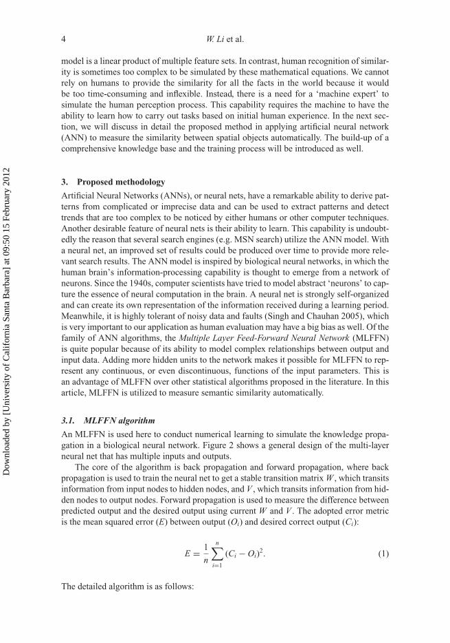
An MLFFN is used here to conduct numerical learning to simulate the knowledge propa-gation in a biological neural network. Figure 2 shows a general design of the multi-layerneural net that has multiple inputs and outputs.
The core of the algorithm is back propagation and forward propagation, where backpropagation is used to train the neural net to get a stable transition matrix W , which transitsinformation from input nodes to hidden nodes, and V , which transits information from hid-den nodes to output nodes. Forward propagation is used to measure the difference betweenpredicted output and the desired output using current W and V . The adopted error metricis the mean squared error (E) between output (Oi) and desired correct output (Ci):
E = 1
n
n∑i=1
(Ci − Oi)2. (1)
The detailed algorithm is as follows:
Dow
nloa
ded
by [
Uni
vers
ity o
f C
alif
orni
a Sa
nta
Bar
bara
] at
09:
50 1
5 Fe
brua
ry 2
012
International Journal of Geographical Information Science 5
O1
H1 H2
I1 I2
O2 O3 Output O
Transition matrix W
Hidden layer H
Transition matrix V
Input I
w11
v11v22
w13
Figure 2. Design of a MLFNN.
(1) Initialize W and V with given boundaries(2) Randomize given data D (a set of input vectors)(3) For each element in D,
a. perform back propagation by
�Wij = −α∂E
∂Wij= α(Ci − Oi)Oi(1 − Oi)Ij (2)
�Vjk =∑
i
Wij�Wij(1 − Hj)Ik (3)
W = W + �W (4)
V = V + �V (5)
b. perform forward propagation as follows:
Hj = σ
(∑k
VjkIk
)(6)
O = σ
⎛⎝∑
j
WijHj
⎞⎠ (7)
where σ (x) = 11+e−u
c. calculate the mean squared error between each output and desired output. If the worsterror is lower than a given good-minimum-error, then the network has completed the train-ing, returning V and W as two transition matrices. If the error is not lower than the givengood-minimum-error, the algorithm will repeat back propagation to continue training thenetwork.
Dow
nloa
ded
by [
Uni
vers
ity o
f C
alif
orni
a Sa
nta
Bar
bara
] at
09:
50 1
5 Fe
brua
ry 2
012

6 W. Li et al.
3.2. The acquisition of prior knowledge
Prior knowledge acts as the training dataset for the neural net. It determines how wellthe transition matrices could be built in the machine learning process. Although a neu-ral net is highly tolerant of noisy data, completeness and representativeness of the priorknowledge is still significant for the accuracy (the closeness of a machine measurement tohuman measurement) of semantic classification in similarity measurement. A neural netrequires that the representation of knowledge be complete because the training processrelies on the explicitly defined knowledge. Any uncertainty in the knowledge definitionmay lead to the failure of the predictive capability of the neural net. Of all the existingmachine languages, DL is able to define a complete knowledge concentrating on a spe-cialized application area. It formalizes the knowledge structure by retaining an emphasison definitions and properties of categories. DL is based on the closed world assump-tion, by which those ground atomic sentences not asserted to be true are assumed to befalse. Therefore, DL is suitable to represent knowledge and to build a domain knowl-edge base or an ontology. The knowledge structure and content defined in the ontologyshould be representative and reflect characteristics of an application domain, such as thegeospatial domain. As discussed in Section 1, humans tend to measure similarity by com-paring features of domain concepts, so to emulate human behaviour a neural net requiresa complete feature set that corresponds to the concepts defined in the knowledge base.Sometimes only a few prominent features determine the similarity, rather than the combi-nation effects of all the features. Therefore, besides the completeness in the definition offeature types, the definition of prominent features of the concepts in a certain domain is alsoimportant.
In this article, the knowledge base of water bodies together with their spatial,temporal and descriptive features/properties is introduced. The sources of the knowl-edge base include SWEET ontology (Raskin and Pan 2005), CUAHSI ontology (http://www.cuahsi.org), GeoWordNet (http://geowordnet.semanticmatching.org/), USGS WaterScience Glossary of Terms (http://ga.water.usgs.gov/edu/dictionary.html) and Wikipedia(http://wikipedia.org). Figure 3 shows all the water body concepts that are modelledontologically in this research. Concepts such as ‘River’, ‘Creek’ and ‘Sea’ forming theinner circle are the core water body concepts used for machine-based training and learn-ing of similarity. The peripheral concepts, such as ‘Burn’ and ‘Draw’, are modelled butnot yet considered in measuring the similarity with other objects in the current phasebecause of the limited information encoded about them in the sources of water bodyontologies/articles.
Figure 4 shows the ontological framework of water body described using 17 fea-tures; the meaning of each is listed in Table 1. The notations on the arrows connect-ing the ‘WaterBody’ node and all the green nodes in Figure 4 are the features thatdescribe a water body object. Other nodes that are descendants of the green nodesare the objects that a ‘WaterBody’ has with a certain predicate, for example a waterbody may have functions {Irrigation, PublicSupply, Recreation, PassengerExchange,EcologicalFlow, PowerPlant, Industry, Building/RepairingBoats, Wildlife, Aquaculture,FloodProtection, Mining, LiveStock, ShipShelter, HydroElectricPower, TransferingCargo,WaterQualityImprovement, ShorelineErosion and Aesthetics}. Each member in this setcan be used to replace ‘Function’ in the triple expression {‘WaterBody’, ‘hasFunction-ality’, Function}. For example, a triple expression {‘WaterBody’, ‘hasFunctionality’,‘PublicSupply’} means that a type of ‘WaterBody’ can be used for supplying water tothe public. Any object that is a subclass of ‘WaterBody’ can be applied to the frameworkwith the specific attribute value defined for that object.
Dow
nloa
ded
by [
Uni
vers
ity o
f C
alif
orni
a Sa
nta
Bar
bara
] at
09:
50 1
5 Fe
brua
ry 2
012

International Journal of Geographical Information Science 7
Figure 3. Water body concepts used for training.
Figure 5 shows semantic definitions of three different water body objects: river, lakeand pond. All of them share the feature set {hasShape, hasSalinityLevel, hasOrigin, has-Depth}, although the range of the features are different. Feature nodes in orange are theones owned only by ‘River’; nodes in green are the ones shared by ‘Pond’ and ‘Lake’ butnot ‘River’. By modelling each water body object, the similarity can be measured more pre-cisely, from the granularity of a set of features (such as that adopted in the MDSM model)down to a single feature. The following section defines the rules for determining the con-tribution of a single feature to the similarity measurement of two or more spatial objects.
3.3. Derivation of training data from the knowledge base and rules
As a neural net is a numerical learning algorithm, it requires numerical input parame-ters. Therefore, there is a need to numerically express the contribution of each featuretoward measuring the similarity of two or more spatial objects. To formulate the rules forcalculating the contribution, consider the following parameters:
k: Index of spatial objects of different kinds;(ta, tb): Pair of spatial objects for similarity measure;fi: One of the 17 features defined inTable 1, i is the index;
Dow
nloa
ded
by [
Uni
vers
ity o
f C
alif
orni
a Sa
nta
Bar
bara
] at
09:
50 1
5 Fe
brua
ry 2
012

8 W. Li et al.
Figure 4. A feature space for “Waterbody”.
Ak = {x | x ∈ Range(tak , fi)}, Bk = {x | x ∈ Range(tbk , fi)}: Range domain of feature igiven objects tak and tbk ;
Sim(fi, tak , tbk ): The contribution of feature fi to the similarity measure betweenta1 and tb1 .
Basically, we can compute any feature’s contribution to the similarity measure of an objectpair(ta1 , tb1 ) using
Sim( fi, ta1 , tb1 ) = |A1 ∩ B1||A1 ∪ B1| . (8)
As Equation (8) shows, the contribution of feature fi in measuring the similarity betweenobjects ta1 andtb1 is the ratio between shared members of A1 and B1 and the range they coverin total. So, the more members shared byA1 and B1, the greater the contribution the featurefi makes to the similarity between objects A1 and B1. However, more rules need to bedefined to handle special cases. The rules are as follows:
Dow
nloa
ded
by [
Uni
vers
ity o
f C
alif
orni
a Sa
nta
Bar
bara
] at
09:
50 1
5 Fe
brua
ry 2
012

International Journal of Geographical Information Science 9
Table 1. Features used to describe a water body concept.
ID Feature Description
1 hasFormationProcess The process through which a water body comes into existence,e.g. glacier retreat.
2 hasPart The parts that compose a water body, e.g. mouth of a river.3 hasExistenceCharacteristic The continuous or periodical existence of water in a water body
over time, e.g. ocean is perpetual.4 hasWaterSource Where is water in the water body from? E.g. precipitation.5 hasExtent The size of a non-linear water body, such as ocean.6 hasWidth The width of a linear water body, such as a river.7 hasDepth The depth of a water body.8 hasShape What shape is the water body in? E.g. a linear river and a
non-linear lake.9 hasShapeProperties If the shape of water body is non-linear, what is the shape like?
E.g. Gulf is a one-side open water body with three sidessurrounded by land.
10 hasTributary Whether a water body has one or more tributary. E.g. A matureriver that flows slowly tends to have many tributaries.
11 hasContainment Whether a water body is formed naturally or is human made.12 hasSalinityLevel The salinity of water, e.g. the water in ocean is salty.13 hasFlowRate The rate indicating how fast water flows in a water body, e.g.
water in a lake is stagnant.14 hasFunction The functionality that a water body can be used for, e.g.
irrigation.15 hasOutflow/hasConfluence Where the water flows to? E.g. rivers always flow into oceans.16 isConnectedTo The water body that a water body is connected with, e.g. a delta
is always connected with sea or ocean.17 hasAdjacentLandform The landform of a water body is next to, e.g. an Arroyo is
always found in mountainous region.
Rule I: For any object pairs (ta1 ,tb1 ) and (ta2 ,tb2 ) and a given feature fi, if
(1) |A1 − B1| · |B1 − A1| = 0 and
(2) |A2 − B2| · |B2 − A2| �= 0
Sim( fi, ta1 , tb1 ) ≥ Sim( fi, ta2 , tb2 ),
when|A1 ∩ B1||A1 ∪ B1| = |A2 ∩ B2|
|A2 ∪ B2| �= ∅.
Rule II: For any object pairs(ta1 ,tb1 ), (ta2 ,tb2 )(ta3 ,tb3 ), if
(1) A1 ∪ B1 �= ∅ and |A1| · |B1| �= 0(2) A2 ∪ B2=∅(3) A3 ∪ B3 �= ∅ and |A3| · |B3| = 0
Sim( fi, ta1 , tb1 ) > Sim( fi, ta2 , tb2 ) > Sim( fi, ta3 , tb3 ).
Dow
nloa
ded
by [
Uni
vers
ity o
f C
alif
orni
a Sa
nta
Bar
bara
] at
09:
50 1
5 Fe
brua
ry 2
012

10 W. Li et al.
Figure 5. Semantic definition of three water body objects.
Case I in Table 2 shows the pairs that fit conditions (1) and (2) in Rule I respectively.For both case I (a) and case I (b), they have the same contribution to similarity given thesame common and total features according to the definition in Equation (8). However, incase I (a), set B1 is completely contained in set A1; therefore, the contribution of a featureto objects in case I (a) should be larger than that in case II (b), as Rule I defined. Given thisrule, the contribution to similarity can be computed as follows:
Sim( fi, ta1 , tb1 ) = |A1 ∩ B1||A1 ∪ B1| ; Sim( fi, ta2 , tb2 ) = β
|A2 ∩ B2||A2 ∪ B2| (9)
where β = threshold ∈ [0.9, 1]As an example, among the set of water body objects {River, Lake, Pond} in Figure 5,
all have the same feature ‘hasShape’. According to other feature-based models, the contri-butions of the feature ‘hasShape’ are the same for each concept pair. But practically, thecontribution of the above feature is larger in {Lake, Pond} pair than {Lake, River} and{Pond, River} pairs because both lake and pond have an oval shape, whereas a river isalways linear. Thus, by considering the values in the range set of each common feature,this method can obtain more accurate values in similarity measurement than other featurematching models.
Case II in Table 2 shows the situation when the two range sets of a feature of two givenobjects have no common element. Case II (a) indicates that both objects share the feature,but does not have any intersection in the range set – condition 1 in Rule II; (b) indicatesthat neither of the objects has feature fi – condition 2 in Rule II; (c) indicates that one objecthas feature fi and the other does not – condition 3 in Rule II. Intuitively, the contributionof feature fi to the similarity should be larger when this feature can be used to describe theobjects than when neither of the objects has this feature, and slightly larger than when one
Dow
nloa
ded
by [
Uni
vers
ity o
f C
alif
orni
a Sa
nta
Bar
bara
] at
09:
50 1
5 Fe
brua
ry 2
012

International Journal of Geographical Information Science 11
Table 2. Case examples for object pairs for Rules I and II.
a , b
c
d
e
fab
g
h
(a) (b)
Case I
a bc d
(a) (b) (c)
e fg
a bc d Case II
B2A2
A1B1
object has the feature and the other does not, as Rule II defines. Given this rule, we definethe contributions as follows:
Sim( fi, ta1 , tb1 ) = α1
|A1 ∪ B1|Sim( fi, ta2 , tb2 ) = αSim( fi, ta1 , tb1 )
Sim(fi, ta3 , tb3 ) = |A3 ∩ B3||A3 ∪ B3| = 0
(10)
where α is a tuning factor (α = 0.5 for this case study). As an example, both water bodies‘Pond’ and ‘River’ have the common feature ‘has Origin’. The range of this feature for‘Pond’ is {GlacierRetreat, Manmade} and that for ‘River’ is {LandErosion, Landslide,Earthquake}. According to Rule II and Equation (10), the contribution of feature ‘hasOrigin’ to the similarity of {Pond, River} is 0.1 (0.5(1/5)) rather than 0, obtained directlyfrom Equation (8).
3.4. Training process
Once rules for calculating contributions of both common and differential features aredefined, the input pattern of the neural net can be mapped from pairs of objects and thesimilarity of the objects computed in Section 3.3.The neural net input includes a vectorof multi-dimensional parameters and a known output result. Features are mapped onto themulti-dimensional parameters, and the value of each parameter is the contribution of thespecific feature to the similarity of the two objects in pairs. The known output result isobtained from human ranking results on the sample data. Through an iterative trainingprocess of the designed neural network, the goal (similarity between the pairs of spatial
Dow
nloa
ded
by [
Uni
vers
ity o
f C
alif
orni
a Sa
nta
Bar
bara
] at
09:
50 1
5 Fe
brua
ry 2
012

12 W. Li et al.
objects ranked by machine is highly correlated to human ranking) can be achieved withgenerated transition matrices.
Another issue for the similarity measurement is the timely update of a similarity matrixas the amount of knowledge (in this case, it is the water body ontology) increases. Oncea new instance is populated into the ontology, its similarity with other instances in theontology will be calculated automatically. Using the obtained transition matrix, a forwardpropagation can be conducted N (number of instances in ontology) times to calculatethe missing similarity values. This achievement is based on the premise that the schema(object-level) of the ontological framework (recall Figure 4) is consistent, or the wholetraining process must be repeated for new transition matrices.
4. Assessing the ANN-based similarity measure approach
A frequently used experiment for assessing the semantic similarity is, to distribute to 38undergraduate subjects 30 pairs of nouns that cover high, intermediate and low levels ofsimilarity (Rubenstein and Goodenough 1965). In this study, the design of the experimentswas slightly different from the one used by Rubenstein and Goodenough (1965) because theconcepts measured are specialized for the hydrology domain, so measurements obtainedfrom subjects who have little background in this domain may be biased because of the lackof domain knowledge.
Therefore, a new experiment was designed to satisfy the criterion mentioned above. Thehuman subjects were asked to provide similarity scores for three groups of concept pairs.Subjects ranked the concept pairs from least to most similar, the lowest score was 0 for theleast similar pair in a group whereas a score of 100 was assigned to the most similar pair.When scoring the similarity of one pair, the subject had to consider the relative distance ofthe similarity of this pair to that of the other pairs within the same group. The three groupsare linear water body non-linear open water body I and non-linear water body II. Accordingto the background of the human subjects (graduate students or hydrology experts), differentsurveys were given. The survey for the graduate subjects included 10 pairs of terms in eachgroup. The survey designed for hydrology experts included all questions in the surveydesigned for graduate subjects, plus 33 other pairs. The extra pairs contained conceptsfrom across groups, e.g. one is from the linear, whereas the other is from the non-linearwater body group, e.g. (River, Lake), as shown in Table 3.
Based on the collected experimental data, the following assessment was conducted toevaluate the performance of ANN when enabling the automated similarity measurement asdescribed in the following sections.
4.1. Quickness of convergence vs learning rate
The learning rate controls the speed of ANN learning by affecting the changes beingmade to the weights of transition matrices at each step. The performance of the ANNalgorithm is very sensitive to the proper setting of the learning rate (Amini 2008). If thechanges applied to the weights are too small, the algorithm will take too long to converge.If the changes are too large, the algorithm becomes unstable and oscillates around theerror surface. This experiment determined the optimum network for automated similaritymeasurement through the result from this learning rate investigation. Here, ‘optimum’ ismeasured by the Mean Square Error (MSE) between the network outputs and the target out-puts obtained from the human subject experiments. The initial parameters used for trainingthe network are shown in Table 4. Parameter 1 is the largest number of steps that the ANN
Dow
nloa
ded
by [
Uni
vers
ity o
f C
alif
orni
a Sa
nta
Bar
bara
] at
09:
50 1
5 Fe
brua
ry 2
012

International Journal of Geographical Information Science 13
Table 3. Survey conducted with human subjects.
Subject type Survey A (linear)Survey B
(non-linear I)Survey C
(non-linear II)Survey D
(cross-group)
Both %(River,Fjord)%(River,Creek)%(River,Brook)%(River,Bayou)%(Creek,Fjord)%(Creek,Arroyo)%(Creek, Brook)%(Brook,Arroyo)%(Creek, Bayou)%(Bayou,Brook)
%(Sea,Ocean)%(Sea,Bay)%(Sea,Gulf)%(Sea,Cove)%(Sea,Harbor)%(Sea,Port)%(Sea,Dock)%(Bay,Gulf)%(Bay,Cove)%(Harbor,Port)%(Harbor,Dock)%(Port,Dock)
%(Port,Dock) %(Swamp,Marsh)%(Wetland,Swamp)%(Wetland,Marsh)%(Wetland,Bog)%(Wetland,Fen)%(Swamp,Bog)%(Swamp,Fen)% Bog,Fen)
Expert subjectonly
%(Bayou,Arroyo)%(Bayou,Fjord)%(Brook,Fjord)%(Fjord,Arroyo)%(River,Arroyo)
%(Ocean,Bay)%(Ocean,Gulf)%(Ocean,Cove)%(Ocean,Harbor)%(Ocean,Port)%(Ocean,Dock)%(Bay,Harbor)%(Bay,Port)%(Bay,Dock)%(Gulf,Cove)%(Gulf,Harbor)%(Gulf,Port)%(Gulf,Dock)%(Cove,Harbor)%(Cove,Port)%(Cove,Dock)
%(Wetland,Fen)%(Marsh,Bog)%(Marsh,Fen)
%(Lake,Arroyo)%(Lake,Bayou)%(Lake,Brook)%(Lake,Creek)%(Lake,Fjord)%(Lake,River)%(Pond,Arroyo)%(Pond,Bayou)%(Pond,Brook)%(Pond,Creek)%(Pond,Fjord)%(Pond,Lake)%(Pond,River)
Table 4. Training parameters.
No. Parameter Value
1 Number of epochs 2000 5000 80002 Goal of performance function 10–3
3 Initial learning rate 0.14 Training time Infinity5 Momentum coefficient 0.9
will run; Parameter 2 is measured by MSE; a value of 10–3 means that the ANN will stoptraining if MSE < 10–3; Parameter 3 is the initial learning rate – in this experiment, thelearning rate was set to different numbers in each training process; Parameter 4 sets thetraining expiration time to infinity. The introduction of Parameter 5 cut down the learningtime and efficiently prevented the network from sticking at local optima.
Figure 6 shows the experimental results of neural network learning rate by the numberof epochs. The X -axis indicates a learning rate ranging from 0.1 to 0.9 with interval 0.1,whereas the Y -axis indicates the number of ANN that must be trained until the result con-verges. As the network training uses heuristic techniques, it tends to become trapped in alocal optimum because of the nature of the gradient descent algorithm from which these
Dow
nloa
ded
by [
Uni
vers
ity o
f C
alif
orni
a Sa
nta
Bar
bara
] at
09:
50 1
5 Fe
brua
ry 2
012

14 W. Li et al.
Figure 6. Number of training runs for the ANN needed in terms of various learning rates.
heuristic techniques were developed (Tan 2002). The strategy used here to compensate forthe sticking problem was to retrain the network until the result achieved the performancefunction goal (MSE < 10–3). The Y -axis records this number.
When the epoch is set to be large, the MSE between the training and target outputs ismore likely to be within the tolerable range; therefore, the network needs fewer trainingruns. But the difference in complexity levels of different problems determines that theabove assertion is not necessarily true. For the automated similarity measurement problem,the assertion is true only when the learning rate is less than 0.3. When the learning rateis more than 0.5, the setting of the epoch will not influence the number of training runsrequired. Another observation is that when the learning rate is less than 0.4, the numberof training runs when the epoch equals 2000 decreases much faster than the decreasingrate of training runs when the epoch equals 5000 and 8000. This means that the designedneural network is most sensitive to change in learning rate when the epoch is set to 2000.Meanwhile, the trend curves in Figure 6 shows that for the same epoch of each trainingprocess, the necessary training runs decreases when the learning rate increases until thelearning rate reaches 0.4. Based on the above analysis, when the epoch equals 2000 andthe learning rate equals 0.4, the ANN performs the best and therefore those parameterswere chosen for the following experiments.
4.2. Prediction accuracy vs number of hidden nodes
One great advantage of the ANN model is its ability to predict. Once experimental dataare collected from human subjects, the neural network can be well trained. Using thetrained network, the ANN model can provide automatic ranking for the pairs of con-cepts that are not ranked by humans. In order to accomplish this performance capacity,the experimental results from the human subjects were divided into two sets: 90% of the
Dow
nloa
ded
by [
Uni
vers
ity o
f C
alif
orni
a Sa
nta
Bar
bara
] at
09:
50 1
5 Fe
brua
ry 2
012
International Journal of Geographical Information Science 15
results are considered as the testing set and the remaining 10% were considered as thevalidation set.
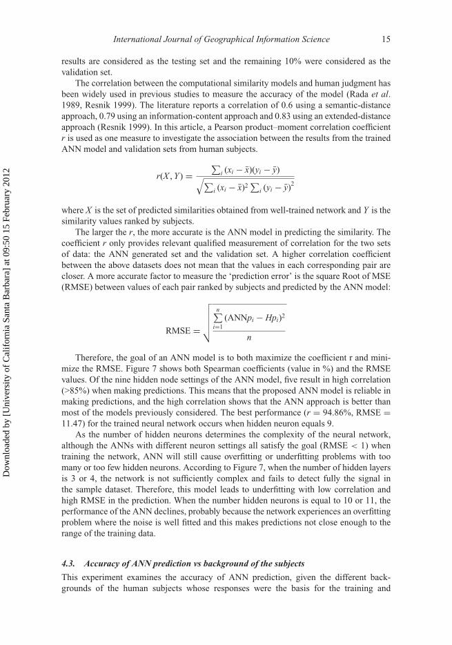
The correlation between the computational similarity models and human judgment hasbeen widely used in previous studies to measure the accuracy of the model (Rada et al.1989, Resnik 1999). The literature reports a correlation of 0.6 using a semantic-distanceapproach, 0.79 using an information-content approach and 0.83 using an extended-distanceapproach (Resnik 1999). In this article, a Pearson product–moment correlation coefficientr is used as one measure to investigate the association between the results from the trainedANN model and validation sets from human subjects.
r(X , Y ) =∑
i (xi − x)(yi − y)√∑i (xi − x)2
∑i (yi − y)2
where X is the set of predicted similarities obtained from well-trained network and Y is thesimilarity values ranked by subjects.
The larger the r, the more accurate is the ANN model in predicting the similarity. Thecoefficient r only provides relevant qualified measurement of correlation for the two setsof data: the ANN generated set and the validation set. A higher correlation coefficientbetween the above datasets does not mean that the values in each corresponding pair arecloser. A more accurate factor to measure the ‘prediction error’ is the square Root of MSE(RMSE) between values of each pair ranked by subjects and predicted by the ANN model:
RMSE =
√√√√√n∑
i=1(ANNpi − Hpi)2
n
Therefore, the goal of an ANN model is to both maximize the coefficient r and mini-mize the RMSE. Figure 7 shows both Spearman coefficients (value in %) and the RMSEvalues. Of the nine hidden node settings of the ANN model, five result in high correlation(>85%) when making predictions. This means that the proposed ANN model is reliable inmaking predictions, and the high correlation shows that the ANN approach is better thanmost of the models previously considered. The best performance (r = 94.86%, RMSE =11.47) for the trained neural network occurs when hidden neuron equals 9.
As the number of hidden neurons determines the complexity of the neural network,although the ANNs with different neuron settings all satisfy the goal (RMSE < 1) whentraining the network, ANN will still cause overfitting or underfitting problems with toomany or too few hidden neurons. According to Figure 7, when the number of hidden layersis 3 or 4, the network is not sufficiently complex and fails to detect fully the signal inthe sample dataset. Therefore, this model leads to underfitting with low correlation andhigh RMSE in the prediction. When the number hidden neurons is equal to 10 or 11, theperformance of the ANN declines, probably because the network experiences an overfittingproblem where the noise is well fitted and this makes predictions not close enough to therange of the training data.
4.3. Accuracy of ANN prediction vs background of the subjects
This experiment examines the accuracy of ANN prediction, given the different back-grounds of the human subjects whose responses were the basis for the training and
Dow
nloa
ded
by [
Uni
vers
ity o
f C
alif
orni
a Sa
nta
Bar
bara
] at
09:
50 1
5 Fe
brua
ry 2
012
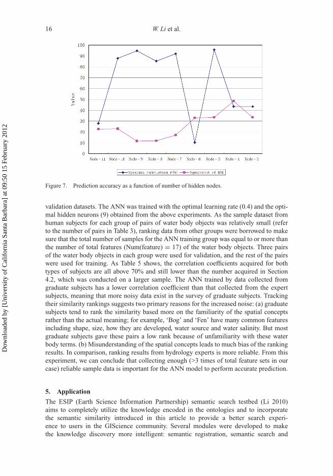
16 W. Li et al.
Figure 7. Prediction accuracy as a function of number of hidden nodes.
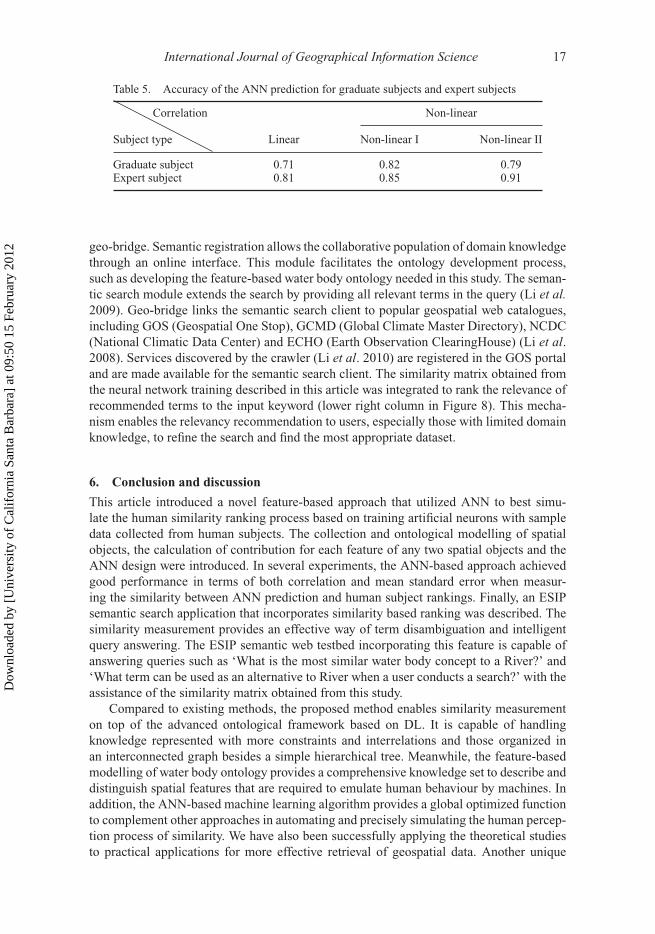
validation datasets. The ANN was trained with the optimal learning rate (0.4) and the opti-mal hidden neurons (9) obtained from the above experiments. As the sample dataset fromhuman subjects for each group of pairs of water body objects was relatively small (referto the number of pairs in Table 3), ranking data from other groups were borrowed to makesure that the total number of samples for the ANN training group was equal to or more thanthe number of total features (Num(feature) = 17) of the water body objects. Three pairsof the water body objects in each group were used for validation, and the rest of the pairswere used for training. As Table 5 shows, the correlation coefficients acquired for bothtypes of subjects are all above 70% and still lower than the number acquired in Section4.2, which was conducted on a larger sample. The ANN trained by data collected fromgraduate subjects has a lower correlation coefficient than that collected from the expertsubjects, meaning that more noisy data exist in the survey of graduate subjects. Trackingtheir similarity rankings suggests two primary reasons for the increased noise: (a) graduatesubjects tend to rank the similarity based more on the familiarity of the spatial conceptsrather than the actual meaning; for example, ‘Bog’ and ‘Fen’ have many common featuresincluding shape, size, how they are developed, water source and water salinity. But mostgraduate subjects gave these pairs a low rank because of unfamiliarity with these waterbody terms. (b) Misunderstanding of the spatial concepts leads to much bias of the rankingresults. In comparison, ranking results from hydrology experts is more reliable. From thisexperiment, we can conclude that collecting enough (>3 times of total feature sets in ourcase) reliable sample data is important for the ANN model to perform accurate prediction.
5. Application
The ESIP (Earth Science Information Partnership) semantic search testbed (Li 2010)aims to completely utilize the knowledge encoded in the ontologies and to incorporatethe semantic similarity introduced in this article to provide a better search experi-ence to users in the GIScience community. Several modules were developed to makethe knowledge discovery more intelligent: semantic registration, semantic search and
Dow
nloa
ded
by [
Uni
vers
ity o
f C
alif
orni
a Sa
nta
Bar
bara
] at
09:
50 1
5 Fe
brua
ry 2
012
International Journal of Geographical Information Science 17
Table 5. Accuracy of the ANN prediction for graduate subjects and expert subjects
Correlation Non-linear
Subject type Linear Non-linear I Non-linear II
Graduate subject 0.71 0.82 0.79Expert subject 0.81 0.85 0.91
geo-bridge. Semantic registration allows the collaborative population of domain knowledgethrough an online interface. This module facilitates the ontology development process,such as developing the feature-based water body ontology needed in this study. The seman-tic search module extends the search by providing all relevant terms in the query (Li et al.2009). Geo-bridge links the semantic search client to popular geospatial web catalogues,including GOS (Geospatial One Stop), GCMD (Global Climate Master Directory), NCDC(National Climatic Data Center) and ECHO (Earth Observation ClearingHouse) (Li et al.2008). Services discovered by the crawler (Li et al. 2010) are registered in the GOS portaland are made available for the semantic search client. The similarity matrix obtained fromthe neural network training described in this article was integrated to rank the relevance ofrecommended terms to the input keyword (lower right column in Figure 8). This mecha-nism enables the relevancy recommendation to users, especially those with limited domainknowledge, to refine the search and find the most appropriate dataset.
6. Conclusion and discussion
This article introduced a novel feature-based approach that utilized ANN to best simu-late the human similarity ranking process based on training artificial neurons with sampledata collected from human subjects. The collection and ontological modelling of spatialobjects, the calculation of contribution for each feature of any two spatial objects and theANN design were introduced. In several experiments, the ANN-based approach achievedgood performance in terms of both correlation and mean standard error when measur-ing the similarity between ANN prediction and human subject rankings. Finally, an ESIPsemantic search application that incorporates similarity based ranking was described. Thesimilarity measurement provides an effective way of term disambiguation and intelligentquery answering. The ESIP semantic web testbed incorporating this feature is capable ofanswering queries such as ‘What is the most similar water body concept to a River?’ and‘What term can be used as an alternative to River when a user conducts a search?’ with theassistance of the similarity matrix obtained from this study.
Compared to existing methods, the proposed method enables similarity measurementon top of the advanced ontological framework based on DL. It is capable of handlingknowledge represented with more constraints and interrelations and those organized inan interconnected graph besides a simple hierarchical tree. Meanwhile, the feature-basedmodelling of water body ontology provides a comprehensive knowledge set to describe anddistinguish spatial features that are required to emulate human behaviour by machines. Inaddition, the ANN-based machine learning algorithm provides a global optimized functionto complement other approaches in automating and precisely simulating the human percep-tion process of similarity. We have also been successfully applying the theoretical studiesto practical applications for more effective retrieval of geospatial data. Another unique
Dow
nloa
ded
by [
Uni
vers
ity o
f C
alif
orni
a Sa
nta
Bar
bara
] at
09:
50 1
5 Fe
brua
ry 2
012

18 W. Li et al.
Figu
re8.
Scr
eens
hoto
fE
SIP
sem
anti
cse
arch
test
bed.
Dow
nloa
ded
by [
Uni
vers
ity o
f C
alif
orni
a Sa
nta
Bar
bara
] at
09:
50 1
5 Fe
brua
ry 2
012

International Journal of Geographical Information Science 19
feature of the proposed method is that the formulation of rules to calculate the contribu-tion of a specific feature to the similarity of two spatial objects makes the context-awaresimilarity measure possible. As an example, in Section 3.3, we computed the contribu-tion of the feature ‘hasShape’ to the similarity measure of {Lake, Pond}, {Lake, River}and {Pond, River}. By applying the rules, we obtained that the contribution of the abovefeature is larger in the {Lake, Pond} pair than the {Lake, River} and {Pond, River} pairsbecause both lake and pond have an oval shape, whereas a river is always linear. This capa-bility could well answer context-aware questions such as ‘Which two water body featuresare more similar in terms of shape?’ Similarly, we will also be able to answer questions inother contexts, such as ‘find the most similar terms to ocean in terms of the salinity level’.
Several potential research directions attract our attention. As a pilot study to validate thefeasibility of this proposed approach, the scale of knowledge encoded in the current waterbody ontology is relatively small. The concepts defined are at the object-level (e.g. ‘River’,‘Lake’) rather than the instance level (e.g. Mississippi river or Lake Manasarovar). Thesimilarity measure on the instantiations of water body concepts can answer more queries,such as ‘Which river is most similar to the Mississippi River?’ In addition to the queriesa search engine can answer currently, the features defined to describe water body conceptswill also allow a search engine to answer extended queries such as ‘Which river is most sim-ilar to the Mississippi River in terms of origin or functionality or geographical location?’To implement this capability, we must extend the current ontological framework to includeinstance-level water body concepts as the next step in this research. In addition, knowledgefrom other science domains, such as geology, biology and astronomy, will also be modelledto validate and promote the ubiquity of the proposed methodology. Furthermore, trainingof the neural net is a time-consuming process, especially when the training set is large andthe underlying pattern is complex. Therefore, parallelizing the algorithm to improve itsefficiency for pre-processing is another issue to be studied.
AcknowledgementThis work was funded by the Earth Science Information Partnership (ESIP) Product and ServiceCommittee and the Federal Geographic Data Committee (FGDC). The authors are grateful toDr. Chaowei Yang, George Mason University, for providing his valuable comments on this research.The authors also thank Mr. Steve McClure for proofreading the article.
ReferencesAmini, J., 2008. Optimum learning rate in back-propagation neural network for classification of
satellite images (irs-1d). Scientia Iranica, 15, 558–567.Berners-Lee, T., Hendler, J., and Lassila, O., 2001. The semantic web – a new form of web con-
tent that is meaningful to computers will unleash a revolution of new possibilities. ScientificAmerican, 284, 28–37.
Budanitsky, A. and Hirst, G., 2001. Semantic distance in WordNet: an experimental, application-oriented evaluation of five measures. Proceedings of the NACCL 2001 Workshop: on WordNetand other lexical resources: applications, extensions, and customizations, 2–7 June, Pittsburgh,USA, 29–34.
Cilibrasi, R. and Vitanyi, P., 2006. Similarity of objects and the meaning of words. Proceedings ofconference on theory and applications of models of computation, 15–20 May, Beijing, China,3959, 21–45.
d’Amato, C., Staab, S., and Fanin, C., 2008. On the influence of description logics ontologies onconceptual similarity. In: A. Gangemi and J. Euzenat, eds., Proceedings of the 16th knowl-edge engineering conference, EKAW2008. Vol. 5268, LNAI . Berlin, Heidelberg: Springer-Verlag,5268, 48–63.
Dow
nloa
ded
by [
Uni
vers
ity o
f C
alif
orni
a Sa
nta
Bar
bara
] at
09:
50 1
5 Fe
brua
ry 2
012
20 W. Li et al.
Eshera, M.A. and Fu, K.S., 1984. A graph distance measure for image-analysis. IEEE Transactionson Systems Man and Cybernetics, 14, 398–408.
Gentner, D. and Markman, A.B., 1995. Similarity is like analogy: structural alignment in compari-son. In: C. Cacciari, ed., Similarity in language, thought and perception, Brussels: BREPOLS,111–147.
Goldstone, R.L. and Son, J., 2005. Similarity. In: K.J. Holyoak & R.G. Morrison, eds., Cambridgehandbook of thinking and reasoning, Cambridge: Cambridge University Press, 13–36.
Janowicz, A., Raubal, M., and Kuhn, W., 2011. The semantic similarity in geographic informationretrieval. Journal of Spatial Information Science, 2, 29–57.
Janowicz, K., 2006. Sim-dl: towards a semantic similarity measurement theory for the descriptionlogic ALCNR in geographic information retrieval. In: R. Meersman, Z. Tari, and P. Herrero, eds.On the move to meaningful internet systems. Proceedings. Part II. Vol. 4278, LNCS 4278. BerlinHeidelberg: Springer-Verlag, 1681–1692.
Kebler, C., 2007. Similarity measurement in context. In: Proceedings of the 6th international andinterdisciplinary conference on Modeling and using context, 20–24 August 2007, Roskilde,Denmark, 4635, 277–290.
Li, W., 2010. Automated data discovery, reasoning and ranking in support of building an intelligentgeospatial search engine. Dissertation (PhD). George Mason University, 168pp.
Li, W., Yang, C., and Raskin, R., 2008. A semantic enhanced model for searching in spatial web por-tals. Proceedings of semantic scientific knowledge integration AAAI/SSKI symposium, StanfordUniversity, Palo Alto, CA, 47–50.
Li, W., Yang, C., and Raskin, R., 2009. A semantic-enabled meta-catalogue for intelligent geospatialinformation discovery. In: Geoinformatics, 2009 17th International Conference, 12–14 August,Fairfax, Virginia, 1–5.
Li, W., Yang, C., and Yang, C., 2010. An active crawler for discovering geospatial web servicesand their distribution pattern – a case study of OGC web map service. International Journal ofGeographical Information Science, 24, 1127–1147.
Lin, D., 1998. An information-theoretic definition of similarity. In: J.W. Shavlik, ed., Proceedingsof the fifteenth international conference on machine learning. San Francisco, CA: MorganKaufmann Publishers Inc, 296–304.
Losif, E. and Potamianos, A., 2007. Unsupervised semantic similarity computation using web searchengines. In: Proceedings of the IEEE/WIC/ACM international conference on web intelligence.Washington, DC: IEEE Computer Society, 381–387.
Medin, D.L., Goldstone, R.L., and Gentner, D., 1993. Respects for similarity. Psychological Review,100, 254–278.
Rada, R., et al., 1989. Development and application of a metric on semantic nets. IEEE Transactionson Systems, Man and Cybernetics, 19, 17–30.
Raskin R. and Pan M., 2005. Knowledge representation in the semantic Web for Earth andenvironmental terminology (SWEET). Computer & Geosciences, 31(9), 1119–1125.
Resnik, P., 1999. Semantic similarity in a taxonomy: an information-based measure and its applica-tion to problems of ambiguity in natural language. Journal of Artificial Intelligence Research,11, 95–130.
Richardson, R., Smeaton, A.F., and Murphy, J., 1994. Using wordnet as a knowledge base for measur-ing semantic similarity between words. In: Proceedings of AICS conference. Berlin, Heidelberg:Springer-Verlag.
Rodriguez, M.A. and Egenhofer, M.J., 2003. Determining semantic similarity among entity classesfrom different ontologies. IEEE Transactions on Knowledge and Data Engineering, 15, 442–456.
Rodriguez, M.A. and Egenhofer, M.J., 2004. Comparing geospatial entity classes: an asymmetricand context-dependent similarity measure. International Journal of Geographical InformationScience, 18, 229–256.
Rubenstein, H. and Goodenough, J.B., 1965. Contextual correlates of synonymy. Communicationsof the ACM , 8, 627–637.
Santos, P., Bennett, B., and Sakellariou, G., 2005. Supervaluation semantics for an inland waterfeature ontology. In: F. Giunchiglia, ed. Proceedings of the 19th international joint conferenceon Artificial intelligence. Edinburgh, Scotland: Morgan Kaufmann Publishers Inc, 564–569.
Sattath, S. and Tversky, A., 1987. On the relation between common and distinctive feature models.Psychological Review, 94, 16–22.
Dow
nloa
ded
by [
Uni
vers
ity o
f C
alif
orni
a Sa
nta
Bar
bara
] at
09:
50 1
5 Fe
brua
ry 2
012
International Journal of Geographical Information Science 21
Schwering, A., 2008. Approaches to semantic similarity measurement for geospatial data: a survey.Transactions in GIS, 12, 5–29.
Schwering, T. and Kuhn, W., 2009. A hybrid semantic similarity measure for spatial informationretrieval. Spatial Cognition and Computation, 9, 30–63.
Seco, N., Veale, T., and Hayes, J., 2004. An intrinsic information content metric for semantic similar-ity in wordnet. In: R.L. de Mántaras and L. Saitta, eds., Proceedings of 16th European conferenceon artificial intelligence. Amsterdam, Netherland: IOS Press, 1089–1090.
Singh, Y. and Chauhan, A.S., 2005. Neural network in data mining. Journal of Theoretical andApplied Information Technology, 5, 37–42.
Sneth, A.P., 1999. Changing focus on interoperability in information systems: from system, syn-tax, structure to semantics. In: M. Goodchild, et al., eds. Interoperating geographic informationsystems. Norwell, MA: Kluwer Academic Publishers, 1–25.
Tan, Y., 2002. A neural network approach for signal detection in digital communication. The Journalof VLSI Signal Processing, 32, 45–54.
Tversky, A., 1977. Features of similarity. Psychological Review, 84, 327–352.Tversky, A. and Gati, I., 1978. Studies of similarity. In: E. Rosch and B. Lloyd, eds. Cognition and
categorization. Hillsdale, NJ: Lawrence Erlbaum, 79–98.
Dow
nloa
ded
by [
Uni
vers
ity o
f C
alif
orni
a Sa
nta
Bar
bara
] at
09:
50 1
5 Fe
brua
ry 2
012