seeing red: baghdad and the event-ful city
TRANSCRIPT

lable at ScienceDirect
Political Geography 29 (2010) 266e279
Contents lists avai
Political Geography
journal homepage: www.elsevier .com/locate/polgeo
Seeing Red: Baghdad and the event-ful city
Derek GregoryDepartment of Geography, The University of British Columbia, 217-1984 West Mall, Vancouver, British Columbia, Canada V6T 1Z2
Keywords:BaghdadBiopoliticsCounterinsurgencyMappingsVisualityWar
E-mail address: [email protected]
0962-6298/$ e see front matter � 2010 Elsevier Ltd.doi:10.1016/j.polgeo.2010.04.003
a b s t r a c t
In late modern war visuality plays a vital role in both the conduct and the rationalization of militaryviolence. This essay explores the techno-cultural apparatus of US military operations and media briefingsin occupied Baghdad from 2003 to 2007. It traces the visual reconfiguration of the city as a space ofevents rather than purely objects. These digital mappings were an intrinsic part of the US Army’scounterinsurgency strategy, and their performances were punctuated by a dialectical interplay ofgeopolitical and biopolitical imaginaries that was focal to the abstraction and legitimation of Americanmilitary intervention.
� 2010 Elsevier Ltd. All rights reserved.
‘As you come out of the heavily guarded [Baghdad] airportcompound, the last message from the US military is written inEnglish on a small metal signpost: “Weapon status red. Lock andload.”’
Rory McCarthy, ‘The view from the Red Zone’,Guardian 29 January 2005
‘After so many weeks in the Red Zone, you have a duty to makea visit to the Green Zone . You go through at least fifteencheckpoints. [to] a parking lot. You drive for scarcely twelveminutes (you tell yourself you could easily have made thejourney on foot), but it’s enough time to pass to the other side ofthe looking-glass.’
Anne Nivat, Bagdad Zone Rouge
Introduction: fields of vision and fields of violence
The intimacy of the relationship between geopolitics and visu-ality has become a central motif of critical analysis (Campbell,2007; McDonald, Dodds, & Hughes, 2010). Their coupling assumesa special significance in late modern war, where the post-Vietnamformation of theMilitaryeIndustrialeMediaeEntertainment networkhas allowed visualization to modulate into a virtualization thatdrives both the execution and, so Der Derian (2009: xxiv) claims,the endorsement of military violence. ‘The new wars are fought inthe same manner as they are represented,’ he insists, ‘by militarysimulations and public dissimulations.’ In what follows I explore
All rights reserved.
this conjuncture by analyzing how visuality e by which I meanculturally (and in this case specifically techno-culturally) mediatedways of seeing e was involved in the conduct of US militaryoperations and media briefings in Baghdad between 2003 and2007. I focus on three issues that suture fields of vision to fieldsof violence.
First, I emphasize the productive power of visuality. Wars havealways been shaped by visual fields, but they have become evermore important under the sign of a Science e the Revolution inMilitary Affairs and its successor projects e that emphasizes therole of digital imagery in the surveillance and reconnaissance thatsupposedly ensures the precision-strike capacity that distinguishesadvanced militaries. These visual fields are more than enclosures,however, separating what is seen from what cannot (or must not)be seen, because their destructive force depends upon a no lessprofound productive power. As Harris (2006: 102) argues, thesetechno-cultural systems ‘not only detect objects and people but alsoproduce both objects on the ground and surveillant subjects.’ Indoing so, they traffic in the narrowing space between the militaryand the public spheres, where actors and observers are interpel-lated as political subjects for whom military violence is ‘renderedeveryday, bureaucratic and even mundane by the technologies andpractices of image production.’ There is nothing axiomatic aboutinterpellation e we are not acquiescent (or as Foucault would say,‘docile’) subjects-in-waiting e but the apparatus of militaryviolence is now so closely entangled with that of visualization thatButler (2009: 29) claims ‘there is no way to separate, under presenthistorical conditions, the material reality of war from those repre-sentational regimes throughwhich it operates and which rationalizeits own operation’ (my emphasis). From this perspective, a vitalconsideration is the way in which advanced militaries representtheir operations as surgical, sensitive and scrupulous so that, at the

D. Gregory / Political Geography 29 (2010) 266e279 267
limit, ‘virtual war’ bleeds into ‘virtuous war’ (Der Derian, 2009).Death disappears from the field of vision to sustain what Coker(2004) sees as a twenty-first century ‘re-enchantment of war’ eor, more accurately, of ‘our’ wars. This rhetorical effect is enhancedby the way in which those same militaries render the actions oftheir (non-state or para-state) enemies as indiscriminate, insensi-tive and illegitimate. Militias, gangs and terrorist groups areengaged in an altogether different set of ‘new wars’ to those in DerDerian’s sights. Their violence is viscerally corporeal and evendiabolical. In this field of vision death stalks the battle space,saturated in blood and bodies by ethno-sectarian violence and anexorbitant cruelty directed overwhelmingly at civilians, andinsurgency becomes the proving ground for a disenchantment ofwar e which is to say, of ‘their’ wars (Gregory, 2010).
This repeated accent on the performativity of the visual fieldintersects with a second issue: the power of the map. It has becomecommonplace to say that maps are not mirrors of the world, thatmapping, ‘even as it claimed to represent the world, produced it’(Pickles, 2004: 93), and it is scarcely surprising that the Pentagon’snew maps of the world became instruments of the Bush adminis-tration’s plans for a New American Century (Barnett, 2004; Dalby,2007).1 But performativity is always contingent and conditional;as Pickles (2004: 66) notes, the map ‘is not a representation of theworld, but an inscription that does (or sometimes does not do) workin the world’ (my emphasis). To unravel that ‘not’, Kitchin andDodge (2007: 335) have proposed a revision to Pickles’prospectus, which they argue continues to privilege the map asobject. In their contrary view the map should be seen as an event,and analysis should be directed toward the mappings throughwhich it flickers into momentary presence:
‘A map is brought into the world and made to do work throughpractices such as recognizing, interpreting, translating,communicating and so on. It does not re-present the world ormake theworld (by shaping howwe think about theworld); it isa co-constitutive production between inscription, individualand world; a production that is constantly in motion, alwaysseeking to appear ontologically secure.’
In outlining the practices through which maps emerge, Kitchinand Dodge challenge their ontological security, and in particular theconceit that they are immutable mobiles located outside theinterpretive fields through which they are co-constituted, and re-present them instead as transitory, fleeting, so many performancesof-the-moment. They are right to be skeptical about the claim ofontological security, which is a peculiarly powerful one. As I willshow, the scientificity of the map e the presumptive objectivity ofthe practices through which it is produced and the validity of thetruth claims that this allows it to register e was an importantmeans through which the US Army asserted its command of thebattle space of Baghdad. Yet even as Kitchin and Dodge widen theiranalytical focus, they confine their attention to mapping and saynext to nothing about the wider ensemble of practices withinwhich mappings are activated. I want to show that the militaryaffirmation of cartographic reason was more than the instantiationof a distinctive spatial imaginary of Baghdad, with its overlay ofAmerican grids, routes and names, and that the US Army invokedthe ontological security of the map as a rhetorical substitute for theoperational security of the city and as a biomedical screen onwhichto confirm its pathological diagnosis of Baghdad.
Third, I connect these performances to biopolitics. Biopolitics isa contested term, of course, and its use here is further complicatedbecause occupied Baghdad was subjected to multiple biopoliticalprogrammes, from the ethno-sectarian violence of the ‘Battle ofBaghdad’ through the covert discrimination in ante- and post-natalcare by the Shia-controlled Health Ministry to the biomedical
armature deployed by the American military in its counterinsur-gency operations. Common to all of them, however, is the figure ofpopulation. Population was focal to Foucault’s development ofa biopolitical imaginary, and he even argued that it was ‘theproblematization of population’ that had made possible the epis-temological transformations that haunted his early work: fromnatural history to biology, from general grammar to philology, andfrom the analysis of wealth to political economy (Foucault, 2007:77e78). I emphasize this e to Foucault ‘marginal’ e claim becausehe made it in a series of reflections on security, and Dillon andLobo-Guerrero (2009: 16) have proposed a further transformationof this ‘life, language and labour’ triad into animation, code andinformation that connects directly to my own concerns. For it is notonly that maps must be understood ‘as events rather than objects’,as Kitchin and Dodge (2007: 342) suggest, but also that themappings of late modern war are increasingly required to producea space composed of events rather than objects. After the fall ofBaghdad the American military found itself moving in a tricksterlandscapewhere it was hard to distinguish insurgents from the restof the population, and its intrinsic indeterminacy compelled theArmy to assemble and animate the new battle space through thefleeting traces of insurgent encounter: the loci of improvisedexplosive devices (IEDs) and car bombs, of dead bodies dumped inthe streets and rivers, and of operations against terrorist cells anddeath squads. The quicksilver capacity of insurgent mutation couldnot be captured by the stock figure of the monstrous, which hadbeen central to the BusheBlair characterizations of the ‘war onterror’, and as the American military acknowledged that insur-gencies had their own rationalities so it initiated a cultural turn tocomprehende to problematizee the population that it now placedat the center of its counterinsurgency operations. This involvedmore than the conflict ethnography proposed by some of its prac-titioners because it required an intimate knowledge of theprocesses and ‘operational codes’ (culture) that sustained sociallife: it was an intrinsically biopolitical audit that involved a real-time monitoring of vital signs. This is no simple metaphor. Trackingthis ‘evental life’ e ‘a moving, mutable, mutating and meta-morphosing target’ (Dillon & Reid, 2009: 44) e diagnosed theinsurgency as adaptive, emergent and, above all, malignant: a sco-pic regime that reinforced the re-enchantment of ‘our’ wars.
The digital divide and the object-city
In the months before the US-led invasion of Iraq, and despiteconstant allegations about the difficulties of United Nationsweapons inspections (Findlay & Mines, 2003), the Bush adminis-tration consistently represented the projected battle space as fullytransparent. This was clear in Secretary of State Colin Powell’spresentation to the UN Security Council on 6 February 2003, whichrelied on a cascade of communications intercepts, maps andsatellite images to establish a rhetorically powerful distinctionbetween (Iraqi) deception and (American) discovery, (Iraqi) evasionand (American) exposure. Later that month, leaflets were droppedover Iraq warning: ‘We can see everything. Do not use nuclear,biological or chemical weapons’ (Fig. 1).
The ability to see not only what was there but also what was nottheremust have bemused Baghdad, but the rapid-fire success of theinvasion was widely seen as a vindication of the Revolution inMilitary Affairs and the force transformation demanded by Secre-tary of Defense Donald Rumsfeld. The Air Force identified a ‘culturaldivide’ of ‘precision and information’ in its strike capacitye the gapbetween ‘industrial-age’ and ‘information-age’warfare e and drewparticular attention to the enhanced speed of its targeting decisions(Deptula, 2008). During the first Gulf War in 1991 the targetingcycle was around three days, but in 2003 the kill-chain was

Fig. 1. ‘We can see everything’ (US Department of Defense/US Central Command Leaflet IZDO38).
D. Gregory / Political Geography 29 (2010) 266e279268
sometimes less than 10 min (Harris, 2006). The Army had initiatedits own Battlefield Digitization Program in 1994, and when Amer-ican troops crossed the Iraqi border barely ten years later many ofthem were crossing a digital divide too. Commanders had anunprecedented capacity to track their forces using transpondersand satellite communications (‘blue force tracking’) and they toocould rely on sophisticated surveillance and targeting systems.These developments were supposed to mark a move from closecombat to ‘standoff precision’, in which most future fighting wouldbe conducted safely e for Americans e over long distances.Boosters like Boot (2003) declared the inauguration of ‘the newAmerican way of war’, while others hailed the invasion as theapotheosis of network-centric warfare. Minimal ground forces (lessthan 10,000 troops) had defeated the much larger Iraqi army in 26days to establish the holy trinity of ‘lightning speed, precise tar-geting [and] information dominance.’ The key was informationtechnology: sensors, weapons systems and communicationssystems had been networked to ‘cut through the fog of war’ andgave troops ‘the clearest picture of the battlefield that soldiers haveever known’ (Nider, 2003).
But this triumphalist view looked very different to observers onthe ground, where one reporter discovered that the image oftechno-supremacy was replaced by ‘an unsung corps of geeksimprovising as they went, cobbling together a remarkable systemfrom a hodgepodge of military-built networking technology, off-the-shelf gear, miles of Ethernet cable, and commercial software.’During twoweeks in the war zone, he added, ‘I never heard anyonemention the Revolution in Military Affairs’ (Davis, 2003). The viewwas also different in hindsight. A review for the Strategic StudiesInstitute of the US Army War College concluded that faith in thepower of an American technological fix overlooked the degradationof the Iraqi military machine by the first Gulf War and the post-warsanctions regime and, crucially, the significance of Iraqi mistakes,not least ‘their systematic failure to exploit the military potential ofurban terrain’ (Biddle et al., 2004: 26). Even Boot conceded that thenew technology was not able to monitor the dispositions of theIraqi Army (‘red force tracking’). Worse, he continued, ‘the Fedayeenand other Iraqi irregulars did not employ the kinds of heavyequipment and robust telecommunications networks that USsurveillance systems were designed to monitor. They generallydrove civilian vehicles not T-72 tanks and spread orders by word ofmouth not radio’ (Boot, 2006: 397).
That last would changee General John Abizaid later complainedthat ‘this enemy is better networked than we are’ (Shachtman,
2007) e but the immediate problem of distinguishing irregularsfrom civilians turned out to be symptomatic of a far deeper one. Forthe visualization of the battle space remained embedded ina traditional object-ontology. This was self-evidently the case for airstrikes against fixed Iraqi targets (‘deliberative targeting’), butground troops were directed to take a series of fixed objects/objectives whose codenames conjured up the wars of the past(‘Objective Patton’, ‘Objective Monty’, ‘Objective Rommel’, even‘Objective Custer’) (Fontenoy, Degen, & Tohn, 2005, chap. 5). Thesituation was even more desperate when they entered the cities.American troops operatedwith urbanmodelse some formalized inField Manuals, computer simulations and Mission Rehearsal Exer-cises, others improvised in the field out of poker chips, shell casingsand even Lego bricks e that reduced places like Baghdad andFallujah to three-dimensional envelopes of buildings and physicalinfrastructures (Gregory, 2009). But as war bled into occupationand back again, and as resistance and insurgency, crime andterrorism jostled for dominance, so these object-ontologiesconspicuously failed to capture the newbattle space. As Lieutenant-General William Wallace observed, ‘this is not exactly the enemywe war-gamed against’, and the claim of a transparent battle spaceyielded to an admission of its opacity. The ‘military potential ofurban terrain’ was now being exploited, not by the Iraqi army butby a gathering, intensifying insurgency. A Pentagon study recog-nized the difficulty of identifying, locating and tracking such‘unconventional targets’ in ‘hostile, highly cluttered environments’like cities where insurgents were indistinguishable from the pop-ulation at large, and called for the military to move to ‘intrusive,close-in, terrestrial means’ of intelligence, surveillance and recon-naissance (Defense Science Board, 2004: 153e154,163e164). Smartcommanders in the field had already acknowledged the imperativeneed to close the gap between their troops and local populations,and it was their ‘rush to the intimate’whichwas eventually codifiedin the new doctrine of counterinsurgency operations (COIN) thatpositioned the population at its center (Gregory, 2008a; US Army,2006). As I must now show, however, this was not only a concep-tual but also a technical challenge: ‘population’ was to be appre-hended in particular ways and by particular means. During hiscommand of Multi-National Corps e Iraq (MNC-I) in 2006e2007,Lieutenant-General Peter Chiarelli expressed his frustration atthose who still imagined the conflict came down to ‘a line that wasdrawn somewhere in the desert. [with] the good guys on one sideand the bad guys on the other side.’ Hewas adamant: ‘We don’t seethat out here.’ Instead, ‘we see Baghdad, a city of anywhere from 5.5
D. Gregory / Political Geography 29 (2010) 266e279 269
to 7.5 million people, where no one’s wearing a uniform’ and it was‘very difficult to pick out who’s for you and who’s against you’(Briefing, 13 December 2006).2 In an attempt to make thosediscriminations, to visualize this new space of military operations,the standard issue object-ontology was overwritten and increas-ingly overridden by an event-ontology: Baghdad was transformedinto an event-ful city.
The event-ful city
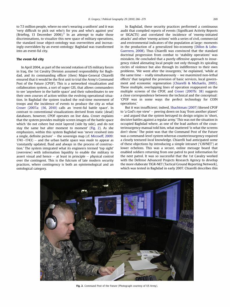
In April 2004, as part of the second rotation of US military forcesin Iraq, the 1st Cavalry Division assumed responsibility for Bagh-dad, and its commanding officer (then) Major-General Chiarelliensured that it would be the first unit to trial the Army’s CommandPost of the Future (CPOF). This is a networked visualization andcollaboration system, a sort of super GIS, that allows commandersto see ‘anywhere in the battle space’ and their subordinates to seetheir own courses of action within the evolving operational situa-tion. In Baghdad the system tracked the real-time movement oftroops and the incidence of events to produce the city as whatCroser (2007a: x56, 2010) calls an ‘event-ful battle space’. Incontrast to conventional visualizations derived from static (dead)databases, however, CPOF operates on live data. Croser explainsthat the system provides multiple screen images of the battle spacewhich ‘do not cohere but exist layered (side by side), and do notstay the same but alter moment to moment’ (Fig. 2). As sheemphasizes, within this system Baghdad was ‘never resolved intoa single, definite picture’ e the sovereign map (cf. Mirzoeff, 2009:1741e1743) e and the urban battle space was made to appear as‘constantly updated, fluid and always in the process of construc-tion.’ The system integrated what its engineers termed ‘top sight’(overview) with information liquidity to enable the military toassert visual and hence e at least in principle e physical controlover the contingent. This is the fulcrum of late modern securitypractices, where contingency is both an epistemological and anontological category.
Fig. 2. Command Post of the Future (P
In Baghdad, these security practices performed a continuousaudit that compiled reports of events (Significant Activity Reportsor SIGACTS) and correlated the incidence of ‘enemy-initiatedattacks’ and other ‘enemy actions’with a series of civil, commercialand environmental indicators of the population at large: momentsin the production of a generalized bio-economy (Dillon & Lobo-Guerrero, 2008). Thus Chiarelli was convinced that the standarddoctrinal progression from combat to ‘stability operations’ wasmistaken. He concluded that a purely offensive approach to insur-gency risked alienating local people not only through its spiralingcircles of violence but also through its indifference to their ownproblems. ‘We went after the insurgents,’ he explained, ‘while atthe same time e really simultaneously ewemaximized non-lethaleffects’ that targeted the provision of basic services, local govern-ment and economic regeneration (Chiarelli & Michaelis, 2005).These multiple, overlapping lines of operation reappeared on themultiple screens of the CPOF, and Croser (2007b: 38) suggestsa close correspondence between the technical and the conceptual:‘CPOF was in some ways the perfect technology for COINoperations.’
But it was insufficient; indeed, Shachtman (2007) likened CPOFto ‘a God’s eye view’ e peering down on Iraq ‘from another planet’e and argued that the system betrayed its design origins in ‘short,decisive battles against a regular army.’ This was not the situation inoccupied Baghdad where, as one of the lead authors of the coun-terinsurgency manual told him, what mattered ‘is what the screensdon’t show.’ The point was that the Command Post of the Futurewas a command-level systemwhereas counterinsurgency requireda closely textured local knowledge. Chiarelli had anticipated someof these objections by introducing a simple intranet (‘CAVNET’) atlower echelons. This was a secure, online message board thatenabled soldiers returning from one patrol to post information forthe next patrol. It was so successful that the 1st Cavalry workedwith the Defense Advanced Projects Research Agency to developthe more elaborate TIGR-NET (Tactical Ground Reporting Network),which was tested in Baghdad in early 2007. Chiarelli describes this
hotograph courtesy of US Army).

D. Gregory / Political Geography 29 (2010) 266e279270
as a virtual notebook, a militarized version of Google Earth andaWiki, where troops can input their own digital images, videos andfield observations into a collaborative, interactive database thatincludes standard satellite imagery and maps. In March 2007 thedatabase contained over 20,000 cumulative entries; by Septemberthere were over 40,000, and more than 60,000 by the end of theyear. Like CPOF, the focus was on a map-based user interface, sothat soldiers could ‘pull back’ events, people and places withina designated area or along a specified patrol route (Fig. 3) (Talbot,2008). Unlike CPOF, however, the system was permissive notprescriptive e Chiarelli (2009) explains that patrol leaders could‘adopt, adapt or discard as their mission analysis dictates’ e and itwas predicated on the rapid, horizontal transmission of informa-tion rather than the standard vertical model of command andcontrol. For this very reason it met with resistance. In a revealingmetaphor, Chiarelli claimed that TIGR ‘spread like a virus’ at lowerechelons while the Army’s ‘institutional antibodies’ tried to kill it(Clark, 2008), a response presumably reinforced in some quartersby hostility to the new counterinsurgency doctrine with which itwas closely aligned. TIGR’s emphasis on local knowledge is clearlyconformable with the new doctrine; so too is the transition froma sovereign model of information to a more capillary model, wherethe threshold of visibility is lowered toward the close-in and inti-mate. These lower-level developments reinforce the production ofBaghdad as an event-ful city, because they invert the pyramid inwhich satellite feeds and imagery from high-altitude drones andother centralized resources are analyzed at command levels andthen filtered down through directivese ‘usually 48 hours later thanthey needed to be,’ as Chiarelli (2009) tartly observed e andsubstitute a much more responsive, fluid, ‘just-in-time’ system ofmonitoring, analysis and decision.
Both CPOF and TIGR were experimental systems, and in theearly years of the occupation it was formidably difficult to integrate
Fig. 3. TIGR screen (Photogra
information flows across the battle space, either vertically or hor-izontally, because there were so many other systems in operation.Wortman (2008: 15) found that Army divisions outside theexperimentation process had customized commercial off-the-shelfsystems (COTS) ‘to visualize data in theway that [made] most senseto them’, and in consequence the Iraqi theater ‘was flooded withnon-Program of Record and COTS equipment’ to fulfill exigentoperational needs. Several reviews sought solutions to the prob-lems of interoperability and data fusion, and in 2007 it was finallydecided to ‘migrate to a single authoritative SIGACT reporting/analysis tool’: the Combined Information Data Network Exchange(CIDNE).
The core of the system was the report of a SIGACT. Even in thisraw form, data capture was far from uniform or consistent. Blankspots on the map could simply indicate an absence of Americanpatrols in an area where insurgent or militia control was unchal-lenged; there were even claims that SIGACTS went unreported incases where battle-weary troops elected to conduct so-called‘search and avoid’ missions rather than ‘just riding around to getblown up’ (Jamail, 2009). Reporter Thomas Ricks was allowed to seethe SIGACTS database for the Baghdad neighborhood where he wasliving in JanuaryeFebruary 2006. Although the area was constantlyrocked by explosions, mortar fire and firefights, he was astonishedto see that it was shown as ‘secure and rated green’. ‘That wasinsane,’ he said. ‘I knew to move through there you needed armedmen and armored cars.’ But then he realized that this was more orless the official definition of ‘secure’ too: ‘if you could drivea Humvee with a 50-caliber machine gun atop it and most of thetime not be attacked.’ He concluded that the database ‘failed tocapture most of what was happening to Iraqis’ (Frontline, 2007). Asthis vignette suggests, the initial focus of event reporting was‘kinetic’ (offensive operations and attacks), and it was not until thenew counterinsurgency doctrine came into effect that political,
ph courtesy of DARPA).

D. Gregory / Political Geography 29 (2010) 266e279 271
social and economic data were incorporated into the system. Inaddition, MNF-I had no systematic means of recording violenceagainst Iraqi civilians until January 2006, though this had notprevented the Pentagon from challenging independent casualtyestimates. A major RAND report concluded that ‘had there beena more robust effort to collect accurate information of Iraqi [civiliancasualties], military strategists and political leaders might haveacted more determinedly to secure the civilian population prior tothe carnage of 2006’ (Hall & Stahl, 2008: 38e40). Perhaps; but thedata remained controversial. MNF-I claimed that civilian casualtyfigures provided by official Iraqi sources were inflated, whereas theRAND study found the opposite to be the case. From December2007 the Pentagon agreed to include data on civilian deathssupplied by the Government of Iraq, but several senior Americanofficers argued that these figures were inflected by sectarianrivalries. There were, in turn, serious questions about the meth-odology used by MNF-I to attribute deaths to ethno-sectarianviolence in its database. I raise these issues simply to emphasizethat the battle space could never be fully transparent. All repre-sentations were, of necessity, mediated by cultural, conceptual andtechnical modalities and, crucially, all claims to ‘know’ the event-fulcity were inescapably partial and situated.
To describe the problem in these terms is to invoke Haraway’s(1991: 183e201) critique of the ‘God-trick’: the claim to seeeverything from nowhere in particular. This matters because theprimary inscription of an event, its constitution as a SIGACT (Fig. 4)with all its uncertainties and limitations, was transmitted down-stream to be digitized and visualized, correlated and ‘cleansed’, sothat it could be aggregated to show trends or mapped to show
Fig. 4. SIGAC
distributions. All the systems for SIGACT recording and analysisinterfaced with visualization and presentation software, which wasused to generate ‘storyboards’ at every level in the chain. Theimportance attached to patrol leaders producing a storyboard (aslide with graphics and text to describe an event) triggeredcomplaints that ‘the one thing I spend more time on than anythingelse here in combat is PowerPoint. I have to make a storyboardcomplete with digital pictures, diagrams and text summaries onanything that happens’ (Unsigned, 2009). The Command Post of theFuture generated PowerPoint storyboards too, which were pre-sented at the daily Battlefield Update Assessments to reviewoperations over the previous 24 hours and to plan future actions.These were highly orchestrated affairs, in which MNF-I and MNC-Iwere linked by teleconference on giant plasma screens, andsummary PowerPoint storyboards assumed a prominent role in theproceedings (Robinson, 2008: 90e91). Most of those remain clas-sified, but some of them were displayed in regular Press Briefingswhere, as I now want to show, they were used to perform anotherversion of the ‘God-trick’.
Spaces of constructed visibility
Its experience in Vietnam had made most of the Americanmilitary averse to counterinsurgency and suspicious of the media,but the changingnature of the campaign in Iraq forcedmanyofficersto cast these reservations aside.When Smith (2006: 17) insisted thatin these newwars ‘wefight amongst the people’he emphasized thatthiswas ‘amplified literally and figuratively by the central role of themedia: we fight in every living room in the world as well as on the
T report.
D. Gregory / Political Geography 29 (2010) 266e279272
streets and fields of a conflict zone.’ Insurgent groups and terroristorganizations knew this very well and it had long been a basicproposition of counterinsurgency too. But theworld had turned. Theclassics of guerilla warfare and counterinsurgency might evoke ‘aworld of flickering projectors and rough propaganda sheets rollingoff inky jungle presses,’ as Payne (2008: 38) remarked, but ‘the rapidevolution of irregular warfare and the modern media’ had trans-formed the practice of late modern war. Audiences were nowmultiple and the global diffusion of digital media made theconnection between events in Iraq and their reception around theworld fast and often furious. In short, SIGACTS assumed an everwidening significance in the battle for the ‘hearts and minds’ of thelocal population and of global audiences. ‘In the virtual dimension,’Betz (2008: 517, 527) argued, ‘the distinction between combatantsand non-combatants, participants and non-participants, observedand observer becomes blurred.’ For the same reason, the firewallbetween what the US military calls ‘Public Affairs’ operations(briefing reporters and managing media access) and ‘InformationOperations’ (psychological warfare and propaganda) was, if notbreached then turned into a gray zone. Public Affairs operations areprimarily directed at domestic American audiences, while the USInformation and Educational Exchange Act (1948) (theSmitheMundt Act) explicitly restricts Information Operations toforeign audiences. But the Pentagon knew that international reportswould feed into domestic channels and that its adversaries moni-tored mainstream American media. The Pentagon also had a keenappreciation of the importance of maintaining domestic support;one of its senior briefers insisted that the first priority of strategiccommunications ‘should be to keep Americans informed and con-nected with their Armed Forces’ (Caldwell & Stroud, 2009: 10).Contractors were hired to produce unsigned television, radio andnewspaper features for a nominally Iraqi audience (Segell, 2009),and retiredmilitary officerswere groomed to act as talking heads onAmerican networks. Other activities were not outsourced, however,and the US military became adept at using digital media. MNF-Iestablished its own website in Arabic and English, sanctionedmilitary blogs, produced podcasts (‘Baghdad 360’) and launched itsown channel on YouTube (MNFIRAQ) (Christensen, 2008). Yet, asCioppa (2009: 34) notes, it was its regular Press Briefings that ‘gaveMNF-I the best opportunity to prepare and execute its messagingcoordination and to frame events.’
From December 2005, and particularly during the first BaghdadSecurity Plan from June through October 2006, these Briefingswereorchestrated bywhat Ricks (2009: 68) calls the ‘razzle-dazzle of U.S.military PowerPoints’. The storyboards were initially exported asflipcharts but over time they were deployed as part of a digitalpresentation and made available online on the MNF-I website. Therise of the ‘PowerPoint Ranger’ has attracted substantial criticism.Colonel Thomas Hammes lambastes the system for its ‘dumbedumb bullets’, which he insists are inimical to careful analysis,while Major-General Michael Flynn complains that ‘commanderswho think PowerPoint storyboards and color-coded spreadsheetsare adequate for describing the Afghan conflict and its complexities’e the same applies to Iraqe ‘have some soul searching to do’ (Flynn,Pottinger, & Batchelor, 2009; Hammes, 2009). Objections like theseecho still sharper criticisms from outside the military, but most ofthem miss the point of PowerPoint in Press Briefings. The mostgeneral are about design and layout, but these apply to visualstrategies that are independent of and pre-date Microsoft’s displaytechnology, though they now circulate more widely because of it.The more specific objections focus on the use of pre-formedtemplates that, according toTufte (2003), ‘weaken spatial reasoningand always corrupt statistical analysis’. The presentations withwhich I am concerned did not use the deadly bullet form, however,and were directed at an explicitly spatial rendition of Baghdad.
What is most significant about the military use of PowerPoint, Isuggest, is that this ‘morphology of demonstration’, as Stark andParavel (2008) call it, turns briefings into ‘displays of virtuosity’that are a strategic means of asserting the operational competencethat Dillon (2007: 19) identifies as the central principle of latemodern security practices.
There are two elements here. First, PowerPoint’s interface withhighly sophisticated systems like CPOF allows storyboards to beexported to its display platform under the signs of Science (ortechno-science) in general and cartographic reason in particular,which plays an important role in establishing the objectivity(‘fidelity’) of the military narrative. Second, if the PowerPoint deck‘turns everything into a sales pitch’, as Tufte (2003) claims, thisdoes not reside in the technology alone but in the performancesthat it entrains. This corporatization of communication e Tufteidentifies the logic of PowerPoint’s cognitive style with the logic ofthe software corporation e made it difficult to hold the linebetween the delivery of a ‘command message’, a proper function ofPublic Affairs, and what one officer criticized as ‘sloganeering ormarketing campaigns’ (Darley, 2005). As a matter of fact a RANDreport for the United States Joint Forces Command soon suggested‘enlisting Madison Avenue’ to ‘shape’ the battle space. Although thefocus of the study was on the use of commercial marketing tech-niques to influence populations in war zones, the authors alsorecommended a review of legal barriers e including theSmitheMundt Act e that they said limited the military use of newmedia in shaping activities (Helmus, Paul, & Glenn, 2007). By thetime it was published, however, the report had been overtaken byevents. The US military was already using the new media, andwhen General David Petraeus assumed command in Iraq he neededno advice about marketing campaigns. He was a professionalbriefer who, ‘with a PowerPoint slide before him, will slip intoa salesman’s rapid-fire patter’ (Coll, 2008), and since he becamecommander of CENTCOM virtually none of his public presentationshas opened without a joke about his reliance on PowerPoint.
In Baghdad Press Briefings were conducted at the CombinedPress Information Center inside the Green Zone, whichChandrasekaran (2006) famously described as the ‘Emerald City’ ethe reference is to the fantasy city in the Wizard of Oz e because itwas semi-detached from life in the rest of Iraq: the Red Zone. By theendof 2003 theworldofmost reporterswasnarrowing,Ricks (2006:359)wrote, and byspring 2004 theworsening security situationhadreducedmost ‘reporting trips [to] dashes to the Green Zone or to thefront gates of US military bases.’ By late March ‘parts of the city ofBaghdad itself began to be crossed off as dangerous’, he continued,and ‘security became so bad that even the short drive across the cityto theGreenZone carried risks thatmade reporterswonderwhetherit was worth it.’ By 2005 ‘journalism under siege’ had become‘journalism at its limits’ (Ricks, 2006: 424). In September theGuardian’s veteranMaggie O’Kane claimed that ‘we no longer knowwhat is going on, but we are pretending we do: any decent reporterknows that reporting from Baghdad does a disservice to the truth’(O’Kane, 2005). Similarly Engelhardt (2005) in November: ‘Wholeareas of Iraq remain beyond our view much, if not all, of the time.’Over the following months, even reporting events in Baghdadbecame next to impossible, as the ‘Battle for Baghdad’ intensifiedand the city was slowly closed to foreign reporters neighborhood byneighborhood (Gregory, 2008b; Schwartz, 2008: 251e269). Theirnews bureaus became fortified installations with secured perime-ters patrolled by private security contractors, located in or near thehandful of hotels that remained open (Axe, 2006). The New YorkTimes bureau chief John Burns admitted that in many cases ‘hoteljournalism’ had become the norm, though it was hardly a life ofluxury, and according to another observer ‘any kind of work outsidethese American fortified zones [had] become so dangerous for
D. Gregory / Political Geography 29 (2010) 266e279 273
foreigners as to be virtually suicidal’ (Schell, 2006). In fact, morejournalists were killed during the Iraq conflict than in any since theSecond World War. The New York-based Committee to ProtectJournalists has identified140 journalists andmediaworkers killed inIraq between March 2003 and October 2009, 117 of them Iraqi; justover half the total (75) were killed in Baghdad, the vast majority byinsurgents or other armed groups.
In these desperate circumstances a new ecology of reportingemerged, relying heavily on local stringers and characterized bywhat Ricchiardi (2006, 2007) called an ‘obstructed view’ fromwhichmuch of the area of operationwas frustratingly ‘out of reach’:Baghdad-based correspondents were ‘hamstrung when it comes toindependently verifying information from military press briefingsor rhetoric from the Pentagon.’ All of this gave the space of con-structed visibility e the phrase is Rajchman’s (1991) e provided byMNF-I Press Briefings an extraordinary power. As Ricks (2006: 361)drily observed, ‘the odd result of the deterioration in security wasthat the harder it became to collect information, the easier it wasfor the Bush administration [and its agents] to assert that steadyprogress was being made in Iraq, but that cowed reporters weren’tseeing it.’
Baghdad as a map
The standard format for the Press Briefings was a preparedstatement by a senior Public Affairs officer, sometimes followed bya statement from a specialist officer or civilian, and then the floorwas open for a question and answer session. The journalists’questions could be remarkably probing, but I do not consider theirreports here e the translation of these briefings e and instead usethe transcripts to explore how the US military staged Baghdad forpublic consumption. Although CPOF and its attendant technologiesproduced Baghdad as ‘messy, complex and ever-mutable’, and the
Fig. 5. Murders in Baghdad, 14 Junee13 July 2
new counterinsurgency doctrine emphasized the fluidity andindeterminacy of the enemy, the public assertion of command e
the public performance of that crucial operational competence e
required the event-ful city to be staged as an ordered, coherenttotality. These public displays worked to stabilize Baghdad visually,imaginatively and rhetorically.
Throughout 2006, and particularly during the first BaghdadSecurity Plan e Operation Together Forward, which started in earlyJuly and was abandoned in October3 e Press Briefings reinstatedthe transparency of the battle space through the assertion of twoprivileges.
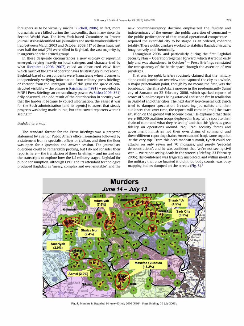
First was top sight: briefers routinely claimed that the militaryalone could provide an overview that captured the city as a whole.A major punctuation point, though by no means the first, was thebombing of the Shia al-Askari mosque in the predominantly Sunnicity of Samarra on 22 February 2006, which sparked reports ofscores of Sunnimosques being attacked and set on fire in retaliationin Baghdad and other cities. The next dayMajor-General Rick Lynchtried to dampen speculation, (re)assuring journalists and theiraudiences that ‘over time, the reports will come in [and] the exactsituation on the ground will become clear.’ He explained that therewere 160,000 coalition troops deployed in Iraq, ‘who report to theirchain of command what they’re seeing’ and that this ‘gives us greatfidelity on operations around Iraq.’ Iraqi security forces andgovernment ministries had their own chains of command, andthese different reporting chains, American and Iraqi, came together‘at the very top’. From this Archimedean summit, Lynch could seeattacks on only seven not 70 mosques, and purely ‘peacefuldemonstrations’, and he was confident that ‘we’re not seeing civilwar . we’re not seeing death in the streets’ (Briefing, 23 February2006). His confidence was tragically misplaced, and within monthsthe military that once boasted it didn’t ‘do body counts’ was busymapping bodies dumped on the streets (Fig. 5).4
006 (MNF-I Press Briefing, 20 July 2006).

D. Gregory / Political Geography 29 (2010) 266e279274
Mapping is the quintessential performance of top sight. Theevent-ful city was produced through two sorts of plots: some, likethis one, recorded traces of terrorist and insurgent activity whileothers recorded military operations against al-Qaeda in Iraq,insurgent cells and death squads.
The second privilegewas the claim of ground truth. Briefers ofteninvoked a special sort of ethnographic authority, trading on first-hand observations of ‘progress’while all the time driving home thenone too subtle point that ‘many of you who haven’t been out therefind this hard to believe’ (Briefing, 13 December 2006). Commentslike these capitalized on the fact thatmilitary patrols could gowherefew journalists could venture, and officers summoned the vastlygreater resources of themilitarymachine to secure their claims. ‘Wevector our tactical units e divisions, brigades and battalions e toconfirm or deny reports,’ Lynch explained: ‘Let’s fly this unmannedaerial vehicle over that mosque and determine whether or notthere’s amosque on fire. Let’s tell the Iraqi security forces tomove tothatmosque anddeterminewhether or not therewas an attack. Andthen you get fidelity on the situation’ (Briefings, 25 February, 2March 2006). These combined operations carried unequal weight,however, and as responsibility for security was transferred to Iraqiforces so Lynch’s successor, Lieutenant-General William Caldwell,worried that ‘the level of fidelity that we used to have as to what’sgoing on the ground becomes less.’ Transition teams offered somecompensation, but since the American military would not be in ‘asmany different places as we were before’ then ‘the information youhave’ would be limited ‘because you just don’t have as much truevisibility’ (Briefing, 14 December 2006; my emphasis).
The connection between top sight and ground truth wasestablished most frequently through the metaphor of ‘walking’
Fig. 6. Operation Together Forward, 27 August 2
reporters through the maps, a trope that became so commonplacethat the distinction between the battle space and its representa-tions was virtually erased. Soon after the start of OperationTogether Forward, when a curfew had been imposed and check-points, patrols and targeted raids increased, Caldwell told reportershe would ‘like to walk you through the statistics of the last 30 days’and showed them a map of attacks in Baghdad district by district.‘As you walk through this,’ he continued, ‘you’ll see that all excepttwo beladiyas [districts] were able to experience a slight decline’(Briefing, 20 July 2006). In August, when the second phase of theoperation was under way, implementing a strategy of ‘clear, holdand build’ neighborhood by neighborhood, Caldwell referred toanother map sequence. He noted that ‘this is the only area that’sbeen specifically cleared’ e coded green on the map (Fig. 6) e buthe predicted that ‘you’ll see those colors expanding out through thecity of Baghdad eventually’ (Briefing, 28 August 2006). In one,magical sentence, the colors bleed from the map to the city.
In September Caldwell showed a density plot of ethno-sectarianmurders and executions (Fig. 7):
‘This is what it was in density, with red being the most dense,the highest number of those who have been murdered executedbeing found in this location here.. And this is what it lookedlike in July. This is what it looked like in August.. And then upin the Kadhamiyah and the Mansour areas, you can see literallyalmost down to nothing here and then a little bit here. We’reencouraged that with more time the density area that you seeon the chart should continue to shrink further down in theAdhamiyah area’ (Briefing, 6 September 2006).
What ‘it’ looked like: at once the map and the city.
006 (MNF-I Press Briefing, 28 August 2006).
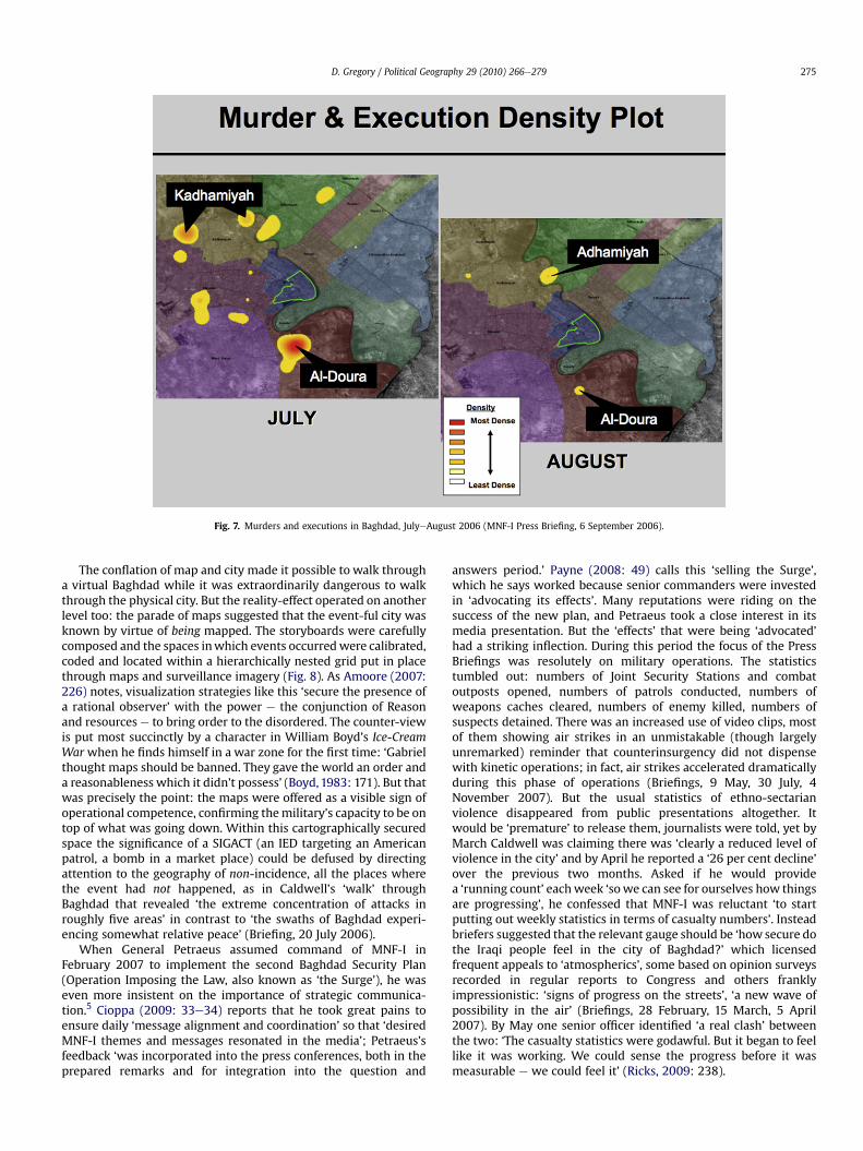
Fig. 7. Murders and executions in Baghdad, JulyeAugust 2006 (MNF-I Press Briefing, 6 September 2006).
D. Gregory / Political Geography 29 (2010) 266e279 275
The conflation of map and city made it possible to walk througha virtual Baghdad while it was extraordinarily dangerous to walkthrough the physical city. But the reality-effect operated on anotherlevel too: the parade of maps suggested that the event-ful city wasknown by virtue of being mapped. The storyboards were carefullycomposed and the spaces inwhich events occurredwere calibrated,coded and located within a hierarchically nested grid put in placethrough maps and surveillance imagery (Fig. 8). As Amoore (2007:226) notes, visualization strategies like this ‘secure the presence ofa rational observer’ with the power e the conjunction of Reasonand resources e to bring order to the disordered. The counter-viewis put most succinctly by a character in William Boyd’s Ice-CreamWar when he finds himself in a war zone for the first time: ‘Gabrielthought maps should be banned. They gave the world an order anda reasonableness which it didn’t possess’ (Boyd,1983: 171). But thatwas precisely the point: the maps were offered as a visible sign ofoperational competence, confirming themilitary’s capacity to be ontop of what was going down. Within this cartographically securedspace the significance of a SIGACT (an IED targeting an Americanpatrol, a bomb in a market place) could be defused by directingattention to the geography of non-incidence, all the places wherethe event had not happened, as in Caldwell’s ‘walk’ throughBaghdad that revealed ‘the extreme concentration of attacks inroughly five areas’ in contrast to ‘the swaths of Baghdad experi-encing somewhat relative peace’ (Briefing, 20 July 2006).
When General Petraeus assumed command of MNF-I inFebruary 2007 to implement the second Baghdad Security Plan(Operation Imposing the Law, also known as ‘the Surge’), he waseven more insistent on the importance of strategic communica-tion.5 Cioppa (2009: 33e34) reports that he took great pains toensure daily ‘message alignment and coordination’ so that ‘desiredMNF-I themes and messages resonated in the media’; Petraeus’sfeedback ‘was incorporated into the press conferences, both in theprepared remarks and for integration into the question and
answers period.’ Payne (2008: 49) calls this ‘selling the Surge’,which he says worked because senior commanders were investedin ‘advocating its effects’. Many reputations were riding on thesuccess of the new plan, and Petraeus took a close interest in itsmedia presentation. But the ‘effects’ that were being ‘advocated’had a striking inflection. During this period the focus of the PressBriefings was resolutely on military operations. The statisticstumbled out: numbers of Joint Security Stations and combatoutposts opened, numbers of patrols conducted, numbers ofweapons caches cleared, numbers of enemy killed, numbers ofsuspects detained. There was an increased use of video clips, mostof them showing air strikes in an unmistakable (though largelyunremarked) reminder that counterinsurgency did not dispensewith kinetic operations; in fact, air strikes accelerated dramaticallyduring this phase of operations (Briefings, 9 May, 30 July, 4November 2007). But the usual statistics of ethno-sectarianviolence disappeared from public presentations altogether. Itwould be ‘premature’ to release them, journalists were told, yet byMarch Caldwell was claiming there was ‘clearly a reduced level ofviolence in the city’ and by April he reported a ‘26 per cent decline’over the previous two months. Asked if he would providea ‘running count’ eachweek ‘sowe can see for ourselves how thingsare progressing’, he confessed that MNF-I was reluctant ‘to startputting out weekly statistics in terms of casualty numbers’. Insteadbriefers suggested that the relevant gauge should be ‘how secure dothe Iraqi people feel in the city of Baghdad?’ which licensedfrequent appeals to ‘atmospherics’, some based on opinion surveysrecorded in regular reports to Congress and others franklyimpressionistic: ‘signs of progress on the streets’, ‘a new wave ofpossibility in the air’ (Briefings, 28 February, 15 March, 5 April2007). By May one senior officer identified ‘a real clash’ betweenthe two: ‘The casualty statistics were godawful. But it began to feellike it was working. We could sense the progress before it wasmeasurable e we could feel it’ (Ricks, 2009: 238).

Fig. 8. Detention of a terrorist suspect (MNF-I Press Briefing, 16 August 2006).
D. Gregory / Political Geography 29 (2010) 266e279276
In July, as briefers began to advertise MNF-I’s ‘tacticalmomentum’, maps reappeared, but there were remarkably few ofthem and they maintained the focus on military operations.Throughout this phase MNF-I released none of its maps of ethno-sectarian violence, which were not put on public view until Pet-raeus displayed them in his PowerPoint presentations to Congresson 10e11 September 2007 (Fig. 9) and again on 8e9 April 2008.
Petraeus’s slides were widely circulated across the web, andtheir critical reception shows how readily these digital decks can beenrolled in what Stark and Paravel (2008: 48e49) call ‘counter-demonstrations’. Critics fastened on the statistical basis for Pet-raeus’s charts and on the unchanging confessional composition ofBaghdad shown on his first series of maps, which conspicuouslyfailed to register the ethnic cleansing of the city that playeda crucial role in reducing the levels of ethno-sectarian violence(Gregory, 2008b). But here I am more interested in their visualrhetoric.
Body counts and biopolitics
Density maps like those shown in Figs. 7 and 9, which the USArmy uses for other mappings too, are the product of a smoothingalgorithm that converts point data into a continuous surface knownas quadratic kernel density estimation (KDE). There are technicalreasons for its use but also powerful rhetorical ones. The maps areknown for their dramatic visual impact, and the desired messagecan be engineered into the production process. One of the mostinfluential handbooks on KDE is published by the US NationalInstitute of Justice and describes how to map crime ‘hot spots’.Several commentators have proposed conceptual affinitiesbetween ‘third-generation’ street gangs, insurgent militias andterrorist groups and ‘fourth-generation warfare’ and their analysishas invited technical collaborations e not least in mapping. The
authors of the NIJ handbook acknowledge that ‘map production isan iterative process’ and that ‘the first map produced is very rarelythe one presented to the target audience.’ They continue: ‘Theintended message should also be seen as the driving force behind whatthe map should look like’ (US National Institute of Justice, 2005: 26,33; my emphasis).
I believe that the same can be said of MNF-I’s mappings, whichwere key media for ‘advocating the effects’ of the Surge. Petraeus’sattention to a coherent command message is well documented, as Ihave said, and he is known to discuss the design of his storyboardsin depth and detail with his staff. It is surely no accident that thesemilitary plots of deaths resemble medical scans of the body politic,where ethno-sectarian violence is visualized as a series of tumors.In his testimony to Congress in April 2008 Petraeus called ethno-sectarian violence ‘a cancer that continues to spread if leftunchecked.’ Here the visual and the verbal work in synch, and themaps become so many visual performances of an intrinsicallybiopolitical field (cf. Campbell, 2007).
Dillon and Lobo-Guerrero (2008: 278) suggest that the presentversion of the Revolution inMilitary Affairs is not simply a technicaltransformation ‘but also a transformation in military strategiccognition throughout which biologised thinking, together withhealth and medical analogies, abound.’ This disposition is manifestin the new counterinsurgency doctrine, which prescribes threeoperational phases: ‘Stop the bleeding’; ‘Inpatient care e recovery’;‘Outpatient care e movement to self-sufficiency’ (US Army, 2006:x5.3e5.6). But counterinsurgency is more than emergency triage,and Petraeus’s senior counterinsurgency adviser describes itsstages as infection, contagion, intervention and rejection. ‘I usea medical analogy advisedly here,’ Kilcullen (2009: 35) explains,‘because just as a virus or bacterium is more easily able to affecta host whose immune system is compromised or to superinfect anexisting wound, so takfiri groups opportunistically exploit existing
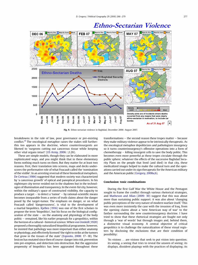
Fig. 9. Ethno-sectarian violence in Baghdad, December 2006eAugust 2007.
D. Gregory / Political Geography 29 (2010) 266e279 277
breakdowns in the rule of law, poor governance or pre-existingconflict.’6 The oncological metaphor raises the stakes still further:this too appears in the doctrine, where counterinsurgents arelikened to ‘surgeons cutting out cancerous tissue while keepingother vital organs intact’ (US Army, 2006: x1.26).
These are simple models, though they can be elaborated in moresophisticated ways, and you might think that in these elementaryforms nothing much turns on them. But they matter for at least tworeasons. First, their translation into screens, maps and decks under-scores the performative role of what Foucault called the ‘nominationof the visible’. In an arresting reversal of these biomedicalmetaphors,De Certeau (1984) suggested that modern society was characterizedby ‘a cancerous growth’ of optical and panoptical procedures. In hisnightmare city terror resided not in the shadows but in the technol-ogies of illumination and transparency. In the event-ful city, however,within the military’s space of constructed visibility, the capacity toproduce a target e to detect a ‘tumor’ e by rational-scientific meansbecomes inseparable from a series of truth claims about the dangerposed by the target-tumor. The emphasis on danger, or on whatFoucault called ‘dangerousness’, is vital to the development ofa martial biopolitics. Kjellen (1916) was one of the first scholars topropose the term ‘biopolitics’, but his focus on the biological config-uration of the state e on the anatomy and physiology of the bodypolitic e remained, like his earlier proposals for a geopolitics, withinthehorizonof a culturalehistorical science.WhenvonUexküll (1920)proposed a thoroughly naturalized biopolitical programme, however,he insisted that pathology was more important than either anatomyorphysiology, andeffectively licensed ‘the right to strikeat the tumorsthat grow in the tissues of the state’ (Esposito, 2008: 17e18). Thelexiconhasmutated since thenof course: danger into risk, preventioninto pre-emption, and detection into destruction. But the aggressivepropensity of biopolitics has been aggravated throughout these
transformations e the second reason these tropes matter e becausetheymakemilitary violence appear to be intrinsically therapeutic. Asthe oncological metaphor depoliticizes and pathologizes insurgencyso it turns counterinsurgency’s offensive operations into a form ofchemotherapy e killing insurgent cells to save the body politic. Thisbecomes even more powerful as these tropes circulate through thepublic sphere; whatever the effects of the successive Baghdad Secu-rity Plans on the people that lived (and died) in that city, thesemedicalized images helped to make the cultural turn and the oper-ations carriedout under its sign therapeutic for theAmericanmilitaryand the American public (Gregory, 2008a,b).
Conclusion: toxic combinations
During the first Gulf War the White House and the Pentagonsought to frame the conflict through various rhetorical strategies,and Matheson and Allan (2009: 30) suggest that this was aboutmore than sustaining public support: it was also about ‘changingpublic perceptions of the very nature of modernwarfare itself.’ Thiswas even more insistently the case with the invasion of Iraq, fromthe opening claims about a ‘new American way of war’ to thefanfare surrounding the new counterinsurgency doctrine. I havetried to show that these rhetorical strategies are fought not onlythrough a ‘war of words’ but through images and, behind them,a distinctive visual economy. A central objective of criticalgeopolitics is to challenge the naturalization of these visual regis-ters by disclosing the exclusions that are their condition ofpossibility:
‘Its visions . are visions that seek to put vision into question;its seeing, a seeing that tries to reveal the unseen of seeing; itsdisplays, dissident playings with the practices of displaying; its

D. Gregory / Political Geography 29 (2010) 266e279278
insight, the insight that comes from the investigation of theinfrastructure of insight’ (O’Tuathail, 1996: 72).
But if Dillon (2007) is right and late modernwar and its securitypractices are distinguished by a ‘toxic combination’ of geopoliticsand biopolitics, then we need to attend to the interplay of theirvisualities.
Geopolitics has long relied on an object-ontology e lines onmaps, lines in the sand e and object-ontologies have played animportant part in wars waged under its sign. They have beenenlisted in both the conduct and the legitimation of modern mili-tary violence, whose objects are reduced to exactly that: strikes aredirected at gun batteries, tanks and buildings, and the people whoinhabit them are made to disappear from view. Late modern warhas not dispensed with these object-ontologies, but uses them tosecure new forms of optical detachment. The usual apparatus of theworld-as-exhibitione the separation of observer and observed, eyeand target (Mitchell, 1988) e is compromised by late modern war,where the video screen often becomes the battle space, but thisdigital transformation has enabled advanced militaries to makenew epistemological claims (about ‘truth’) that are also alwaysethical claims (about ‘targets’). Thus we are assured that intelli-gence, surveillance and reconnaissance now provide such anaccurate and detailed view of the battle space that precision-strikecapacity can be directed (‘surgically’) against infrastructure e
power stations, communications systems, bridges e and invited todraw a duplicitous distinction between targeting ‘the means of life’and targeting the lives of those who depend on them. This mode ofcartographic reason continues to yoke objectivity to what I call‘object-ness’: ‘Ground truth vanishes in the ultimate “God-trick”,whose terrible vengeance depends on making its objects visibleand its subjects invisible’ (Gregory, 2004: 54).
The rise of an event-ontology puts this whole apparatus at risk,however, because it introduces a new, intrusive intimacy across thebattle space of late modern war. Those who operate Predatordrones in the United States, thousands of miles from their targets,claim that the high-resolution imagery of their ‘kills’ makes itimpossible for them to screen out the bodies from the battle space:their elevated view telescopes down to the ground and they tooclaim to be vulnerable to post-traumatic stress disorder. Troopswho have video access to these eyes in the sky are much moredirectly immersed in the space of violence, of course, and theirenrollment in the biopolitical armatures of counterinsurgencyrequires a three-dimensional recognition of the lives (and deaths)of the local populations amongst whom they fight. They areengaged in more than the armed social work that Kilcullen (2009)advertises, and their multiple lines of operation cannot be reducedto the screens of CPOF or TIGR that capture only the fleeting tracesof their encounters with thosewho inhabit the city. In short, opticaldetachment is threatened by a battle space that is visibly andviscerally alive with death; biopolitics bleeds into necropolitics.And yet the Press Briefings that are parasitic upon these visuali-zations move in a dialectical spiral, and their carefully orchestratedparade of maps, screens and decks reinstates optical detachment.For even as the distancing apparatus of the world-as-exhibition isdissolved and the map becomes the city, so the city becomes themap: and in that moment e in that movement e Baghdad istransformed into an abstract geometry of points and areas andreturned to the field of geopolitics. And as those maps areanimated, the body politic is scanned, and the tumors visiblyshrink, so Baghdad is transformed into a biopolitical field whose‘death-producing activities [are hidden] under the rhetoric ofmaking live’ (Dauphinee & Masters, 2007: xii). In this looking-glassworld bodies are counted but they do not count; they become thesigns of a pathological condition and the vector of recovery. These
processes of abstraction are, of course, profoundly embodied. Thisis not algorithmic war, and behind every mark on the map/city isa constellation of fear and terror, pain and grief (Hyndman, 2007).For that very reason our disclosure of the infrastructure of insightcannot be limited to the nomination of the visible.
Acknowledgments
This is a revised version of my lecture to the Critical Geopoliticsconference at Durham in September 2008. I am grateful to DavidCampbell and Marcus Power for their invitation, encouragementand patience, and for the comments of three anonymous referees.
Endnotes
1 Barnett’s book was based on a PowerPoint brief he prepared at the Office of ForceTransformation in the Pentagon after 9/11.2 All MNF-I Press Briefings and Operational Updates are cited in this form; they arearchived at http://www.usf-iraq.com. MNC-I was established in Baghdad in May2004 as the tactical unit responsible for command and control of operationsthroughout Iraq; it formed part of Multi-National Force e Iraq (MNF-I). On 1January 2010 MNF-I was replaced by United States Forces e Iraq.3Operation Together Forward was a joint USeIraqi operation that involved nightlycurfews and the deployment of 12,000 additional American troops to step uppatrols and checkpoints throughout the city. The troops worked from large basesremote from local populations, and in the second phase, when they adopted theCOIN strategy of ‘cleareholdebuild’ in selected (mainly Sunni) neighborhoods, theircontinued dependence on the Forward Operating Bases ensured that ‘clearing’would be far easier than ‘holding’ or4As the storyboard shown here implies, the only deaths recognized within this gridwere those of civilians killed by insurgents; there was no space for civilians killedby the military. Liz Sly from the Chicago Tribune pressed Caldwell about this: ‘Allyour predecessors have refused to tell us the number of civilians that have beenshot dead by American forces over the years. They’ve told us that the figures aren’tkept.’ In the light of the Haditha incident, however, could he ‘request to see if thesefigures are in fact kept and whether we could have them?’ Caldwell wasnoncommittal; he had never seen any figures, yet he knew (somehow) that ‘civiliandeaths are in fact on the rise but not by military forces’: Briefing, 1 June 2006.5Operation Imposing the Law was a joint USeIraqi operation, which involved21,000 additional American troops and a systematic dispersal from ForwardOperating Bases into Joint Security Stations in the neighborhoods. It was widelyadvertised as a successful application of the new counterinsurgency doctrine butthe changing incidence of violence had a more complex causality (Gregory, 2008b).6 Kilcullen uses takfiri to identify Islamist groups that hold that Muslims with beliefsdifferent to their own ‘are infidels who must be killed’ and which regard terrorismas a legitimate weapon against them (pp. xviiexix).
References
Amoore, L. (2007). Vigilant visualities: the watchful politics of the ‘War on Terror’.Security Dialogue, 38, 215e232.
Axe, D. (2006). Reporters in the Danger Zone: fear and loathing in Baghdad. SpiegelOnline, 21 January.
Barnett, T. (2004). The Pentagon’s new map: War and peace in the twenty-firstcentury. New York: Putnam.
Betz, D. (2008). The virtual dimension of contemporary insurgency and counter-insurgency. Small Wars and Insurgencies, 19, 510e540.
Biddle, S., Embrey, J., Filiberti, E., Kidder, S., Metz, S., Oelrich, I., & Shelton, R. (2004).Toppling Saddam: Iraq and American military transformation. Carlisle, PA: Stra-tegic Studies Institute, US Army War College.
Boot, M. (2003). The new American way of war. Foreign Affairs, 82(4), 41e58.Boot, M. (2006). War made new: Technology, warfare and the course of history. New
York: Penguin.Boyd, W. (1983). An ice-cream war. London: Penguin.Butler, J. (2009). Frames of war: When is life grievable? London: Verso.Caldwell, W. B., & Stroud, S. (2009). Fostering a culture of engagement. Military
Review, 10e17 September/October.Campbell, D. (2007). Geopolitics and visuality: sighting the Darfur conflict. Political
Geography, 26, 357e382.Chandrasekaran, R. (2006). Imperial life in the Emerald City: Inside Iraq’s Green Zone.
New York: Knopf.Chiarelli, P. (2009). Remarks delivered at 10th Annual Knowledge Management
Conference, Washington, DC, 28 April.Chiarelli, P., & Michaelis, P. (2005). Winning the Peace: the requirement for full-
spectrum operations. Military Review, 4e17 JulyeAugust.Christensen, C. (2008). Uploading dissonance: youtube and the US occupation of
Iraq. Media, War and Conflict, 1, 155e175.Cioppa, T. M. (2009). Operation Iraqi Freedom: strategic communication analysis
and assessment. Media, War and Conflict, 2, 25e54.

D. Gregory / Political Geography 29 (2010) 266e279 279
Clark, C. (2008). Army Vice touts TIGR; success ‘in spite of’ system. DOD Buzz athttp://www.dodbuzz.com, 2 December.
Coker, C. (2004). The future of war: The re-enchantment of war in the twenty-firstcentury. Oxford: Blackwell.
Coll, S. (2008). The general’s dilemma. New Yorker, 8 September.Croser, C. (2007a). Networking security in the space of the city: event-ful battle-
spaces and the contingency of the encounter. Theory and Event, 10(2).Croser, C. (2007b). Organising complexity: Modes of behaviour in a networked battle-
space. Australian Army, Land Warfare Studies Centre. Working Paper 133.Croser, C. (2010). The new spatiality of security: Operational uncertainty and the US
military in Iraq. London: Routledge.Dalby, S. (2007). The Pentagon’s new imperial cartography: tabloid realism and the
‘war on terror’. In D. Gregory, & A. Pred (Eds.), Violent geographies: Fear, terrorand political violence (pp. 295e308). New York: Routledge.
Darley, W. (2005). Why public affairs is not information operations. Army, January.Dauphinee, E., & Masters, C. (Eds.). (2007). The logics of biopower and the war on
terror: Living, dying, surviving. London: Palgrave.Davis, J. (2003). If we run out of batteries this war is screwed. Wired, 11(06).De Certeau, M. (1984). The practice of everyday life (S. Rendell, Trans.). Berkeley, CA:
University of California Press.Defense Science Board. (2004). Report of summer study on transition to and from
hostilities. Washington, DC: Defense Science Board.Deptula, D. (2008). ISR e precision strike capabilities and technology improve-
ments. Keynote address, Precision Strike Technology Symposium, The JohnsHopkins University, Baltimore, October.
Der Derian, J. (2009). Virtuous war: Mapping the militaryeindustrialemediaeentertain-ment network (2nd ed.). New York: Routledge.
Dillon, M. (2007). Governing terror: the state of emergency of biopolitical emer-gence. International Political Sociology, 1, 7e28.
Dillon, M., & Lobo-Guerrero, L. (2008). Biopolitics of security in the 21st century: anintroduction. Review of International Studies, 34, 265e292.
Dillon, M., & Lobo-Guerrero, L. (2009). The biopolitical imaginary of species-being.Theory, Culture and Society, 26, 1e23.
Dillon, M., & Reid, J. (2009). The liberal way of war: Killing to make life live. London:Routledge.
Engelhardt, T. (2005). ‘Hotel journalism’ not the essence of what’s happening inIraq. TomDispatch at http://ww.tomdispatch.com, 3 November.
Esposito, R. (2008). Bíos: Biopolitics and biophilosophy (T. Campbell, Trans.). Min-neapolis: University of Minnesota Press.
Findlay, T., & Mines, B. (2003). UNMOVIC in Iraq: opportunity lost. In T. Findlay (Ed.),Verification yearbook 2003 (pp. 45e63). London: VERTIC.
Flynn, M. T., Pottinger, M., & Batchelor, P. (2009). Fixing Intel: A blueprint for makingintelligence relevant in Afghanistan. Washington, DC: Center for a New AmericanSecurity.
Fontenoy, G., Degen, E., & Tohn, T. (2005). On point: The US army in Operation IraqiFreedom. Annapolis, MD: US Naval Institute Press.
Foucault, M. (2007). Security, territory, population: Lectures at the Collège de France,1977e1978 (G. Burchell, Trans.). Houndmills: Palgrave Macmillan.
Frontline. (2007). Endgame: edited transcript of interviews with Thomas Ricks. 8January and 1May, at http//:www.pbs.org/wgbh/frontline/endgame/interviews/ricks.html.
Gregory, D. (2004). The colonial present: Afghanistan, Palestine, Iraq. Oxford: Blackwell.Gregory, D. (2008a). ‘The rush to the intimate’: counterinsurgency and the cultural
turn in late modern war. Radical Philosophy, 150, 8e23.Gregory, D. (2008b). The biopolitics of Baghdad: counter-insurgency and the
counter-city. Human Geography, 1, 8e23.Gregory, D. (2009). American military imaginaries and Iraqi cities: the visual 8
January and 1 May, at economies of globalizing war. In C. Lindner (Ed.), Global-ization, violence and the visual culture of cities (pp. 67e84). New York: Routledge.
Gregory, D. (2010). War and peace. Transactions of the Institute of British Geogra-phers, 35, 154e186.
Hall, K., & Stahl, D. (2008). An argument for documenting casualties: Violence againstIraqi civilians 2006. RAND National Defense Research Institute. pp. 38e40.
Hammes, T. X. (2009). Dumbedumb bullets. Armed Forces Journal, July.Haraway, D. (1991). Simians, cyborgs and women: The reinvention of nature. New
York: Routledge.Harris, C. (2006). The omniscient eye: satellite imagery, ‘battlespace awareness’ and
the structures of the imperial gaze. Surveillance and Society, 4, 101e122.Helmus, T., Paul, C., & Glenn, R. (2007). Enlisting Madison avenue: The marketing
approach to earning popular support in theaters of operation. Santa Monica, CA:RAND.
Hyndman, J. (2007). Feminist geopolitics revisited: body counts in Iraq. ProfessionalGeographer, 59, 35e46.
Jamail, D. (2009). Refusing to comply. TomDispatch at http://www.tompdispatch.com, 30 June.
Kilcullen, D. (2009). The accidental guerilla: Fighting small wars in the midst of a bigone. New York: Oxford University Press.
Kitchin, R., & Dodge, M. (2007). Rethinking maps. Progress in Human Geography, 31,331e344.
Kjellen, R. (1916). Staten som Lifsform. Stockholm: Hugo Gebers.Matheson, D., & Allan, S. (2009). Digital war reporting. Cambridge: Polity.McDonald, F., Dodds, K., & Hughes, R. (Eds.). (2010). Observant states: Geopolitics and
visual culture. London: I.B. Tauris.Mirzoeff, N. (2009). War is culture: global counterinsurgency, visuality and the
Petraeus Doctrine. PMLA, 124, 1737e1746.Mitchell, T. (1988). Colonising Egypt. Cambridge: Cambridge University Press.National Institute of Justice. (2005). Mapping crime: Understanding hot spots. US
Department of Justice. Special Report, August.Nider, S. (2003). Transformative military plan vindicated in Iraq. The Hill, 21 May.O’Kane, M. (2005). An end to macho war reporting. Guardian, 29 September.O’Tuathail, G., [Gerard Toal] (1996). Critical geopolitics. Minneapolis: University of
Minnesota Press.Payne, K. (2008). Waging communication war. Parameters, 38(2), 37e51.Pickles, J. (2004). A history of spaces: Cartographic reason, mapping and the geo-coded
world. New York: Routledge.Rajchman, J. (1991). Philosophical events: Essays of the 80s. New York: Columbia
University Press.Ricchiardi, S. (2006). Out of reach. American Journalism Review, 28(2), 24e31.Ricchiardi, S. (2007). Obstructed view. American Journalism Review, 29(2), 26e33.Ricks, T. (2006). Fiasco: The American military adventure in Iraq. New York: Penguin
Press.Ricks, T. (2009). The gamble: General David Petraeus and the American military
adventure in Iraq, 2006e2008. New York: Penguin Press.Robinson, L. (2008). Tell me how this ends: General David Petraeus and the search for
a way out of Iraq. New York: PublicAffairs.Schell, O. (2006). Baghdad: the besieged press. New York Review of Books, 6 April.Schwartz, M. (2008). War without end: The Iraq war in context. Chicago: Haymarket
Books.Segell, G. M. (2009). Creating intelligence: information operations in Iraq. Interna-
tional Journal of Intelligence and Counter Intelligence, 22, 89e109.Shachtman, N. (2007). How technology almost lost the war. Wired, 15(12).Smith, R. (2006). The utility of force: The art of war in the modern world. London:
Penguin.Stark, D., & Paravel, V. (2008). PowerPoint in public: digital technologies and
the new morphology of demonstration. Theory, Culture and Society, 25(5),30e55.
Talbot, D. (2008). A technology surges. Technology Review, 111(2), 70e75.Tufte, E. R. (2003). The cognitive style of PowerPoint. Cheshire, CT: Graphics Press.von Uexküll, J. (1920). Staatsbiologie: Anatomie, Phisiologie, Pathologie des Staates.
Berlin: Gebrüder Paetel.Unsigned. (2009). Leadership and laptops on combat deployments. Army 100e110,
March.US Army Field Manual 3-24: Counterinsurgency. (2006). Washington. DC: Depart-
ment of the Army.Wortman, C. (2008). Inefficient battle command results from unique commanders’
solutions. US Army War College Strategy Research Project.