sedimentary facies association with evidences of tidal ... · p - 206 sedimentary facies...
TRANSCRIPT

P - 206
Sedimentary Facies Association with Evidences of Tidal Reworking in Lakadong Member – An example from Baghjan Field,
Upper Assam Basin, India
Bhaskar Chakrabarti*(Schlumberger Asia Services, India), Binayananda Bharali (Oil India Limited),
Chandramani Srivastava (Schlumberger Asia Services, India), Neelimoy Baruah (Oil India Limited), Email:[email protected]
Summary
The Lakadong Member of Sylhet Formation comprise of good reservoir facies within Paleocene-Eocene petroleum system of Upper Assam Basin. A regional sedimentological study is very much essential for better understanding of the environment of deposition and distribution of reservoirs within Lakadong. The present study constitutes an early phase of an upcoming regional study with a focus on the paleo-facies distribution within Lakadong. The approach to this study incorporates the observation results of high resolution electrical image logs along with other conventional open-hole log suite to achieve the objective. The present study reveals that in the north eastern part of the basin, Lakadong Member essentially represents deltaic sedimentation in its bottom part with tidal influenced estuarine environment becoming dominant in the middle part and tidal reworked delta mouth bar in the upper part. Fluctuating energy condition leading to periodic alternations of sand and clay /shale along with increasing intensity of bioturbation towards the top observed within bypassed channel-fill sequence on image log are indicative of tidal influence. Rhythmic sand-clay /shale alternations, foreset dip distribution indicative of ebb and flood current, flaser bedding, drape surfaces and sharp contacts between individual layers are well documented on image log and augment the idea of possible reworking of deltaic clastic deposits by tidal activity. Six distinct sedimentary facies have been identified within Lakadong Member based on textural features and dip pattern observation from the image log. A total of twelve sedimentary facies associations have been observed after vertical integration, of which delta mouth bar appears to be the dominant facies. Dip patterns within cross bedded sand units suggest delta mouth bar pro- gradation direction mainly towards ENE to NE with ESE on a few occasions, there by suggesting paleo-shoreline orientation during deposition of Lakadong sequence to be WNW-SSE. Tidal reworked sands show dominant flood current direction towards SSW. The entire interval of Lakadong is representative of transition from a fluvial dominated delta system to an estuarine environment and finally to a tidally reworked delta system. The presence of tidal reworking has possibly given the wide dispersion of sands within Lakadong.
Introduction
The newly discovered Baghjan field is located in the northeastern most part of the basement high trend that runs along the southern bank of River Brahmaputra (Fig.1). Well evidences indicate that Lakadong sequence is on an
average 110-120m thick in the Baghjan area with good development of sandstone reservoir. Sedimentary facies associations are essential to understand the regional distribution and geometry of reservoir sand bodies within Lakadong. The present study focuses on the general facies association of Lakadong, striving to document the paleo- agents

responsible for reworking and dispersal of these sands. In this context, recognition of sedimentary features characteristic of specific depositional setting with associated dip patterns are of prime importance. Standard open hole logs, due to their resolution limitations can not document these features. Therefore, the current approach has been undertaken by integrating image log observation with open hole log suite and available geological and geophysical information in this context.
JONAI
ARUNACHAL PRADESH RE BAGHJAN
I VDHEMAJI R
DIBRUGAR
A
P A S S AT DULIAJA DIGBO
U
P Moran NAMRUPA
MH LAKW A
A SIBSAGAR DULIAJA
R
B GELEKI
JORHAT
Figure 1: Location Map showing Baghjan Field in Upper Assam Shelf Basin (Not to Scale)
Methodology
Image log data was processed subsequent to log quality control checks. Dips were picked interactively in workstation on oriented image. Dip classification was done based on features identified on the image. Bed boundary dips of shale/ mudstone and siltstone sections were considered for estimation of structural dip in the processing software. Structural dips in the study interval were observed to be low and hence not removed. Litho-facies in the study interval was established with the help of open hole logs (GR, Resistivity, Neutron porosity and Density), lithology identified/estimated from openhole logs, and image log. Sedimentary facies are recognized on image log by differentiating depositional elements based on borehole image texture (Chunming Xu, 2007). This was followed byvertical integration of image facies with depositional system to reconstruct the paleo-depositional environment. A detailed flow diagram showing all the processes for the study is given in Fig.2.
Examples
Five distinct lithofacies were identified within the Lakadong section viz., Sandstone, Siltstone, Shale/ Mudstone, Carbonaceous Shale and Coal based on conventional openhole logs, image logs and cutting data. Image texture and sedimentary dip pattern has led to the
identification of few sedimentary facies (Prosser et.al, 1998) which are explained in figures 3, 4 and 5. On the other hand, based on facies association, twelve depositional units can be identified within the Lakadong (Table-1). Six distinct facies of Lakadong Member are illustrated in figures 6, 7, 8, 9 and 10. Dip vector plot and rose of currentbeddings in tidal reworked bars are shown in Fig.11.
Figure 2: Flow diagram of methodology

Figure 3: Sedimentary Facies association in sandstone
Figure 4: Sedimentary Facies in Shale, Carbonaceous shale
Figure 5: Bioturbated Facies
Facies Average Inferred PaleocurrentAssociation Thickness Facies
XII 7m Moderately No currentbioturbated structuredelta plainmud
XI 10m Tidal NE to Eastreworked
delta mouthbar
distributarychannel
X 20m Prodelta No currentmud flat to structure
interdistributary
bay fillIX 10m Isolated No current
distal delta structurelobes
VIII 6m Muddy tidal No currentflat structure
VII 11m Tidal Floodreworked current- SW
bar to SSWEbb current-
EastVI 12m Delta plain No current
swamp structureV 4m Delta Mouth Mouth bar-
bar ENE-NEIV 12m Estuary No current
structureIII 6m Tidal No current
influenced structurebioturbatedestuarinebypass
channel fillII 11m Bioturbated No current
estuarine structuremud
I 6m Mouth bar Mouth bar –Distributary ENE-East
channel Channel-South
Table 1: Facies Association in Lakadong

Figure 6: Delta mouth bar – Distributary channel F acies in FMI (left) and paleocurrent roses (right).
Figure 7: FMI log: Moderately bioturbated Estuarine mud (Left) .Completely bioturbated Estuarine bypass channel fill (right); intensity of bioturbation increases towards top.
Figure 8: Image log: Delta plain swamp with intermediatecarbonaceous shale and coal occuring at the top.
Figure 9: Image log: Moderately bioturbated muddy tidal flat.
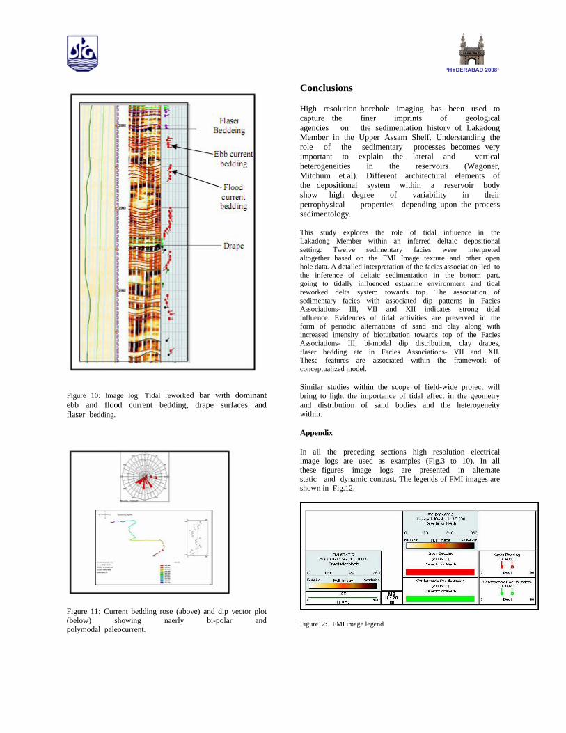
Figure 10: Image log: Tidal reworked bar with dominant ebb and flood current bedding, drape surfaces and flaser bedding.
Figure 11: Current bedding rose (above) and dip vector plot (below) showing naerly bi-polar and polymodal paleocurrent.
Conclusions
High resolution borehole imaging has been used to capture the finer imprints of geological agencies on the sedimentation history of Lakadong Member in the Upper Assam Shelf. Understanding the role of the sedimentary processes becomes very important to explain the lateral and vertical heterogeneities in the reservoirs (Wagoner, Mitchum et.al). Different architectural elements of the depositional system within a reservoir body show high degree of variability in their petrophysical properties depending upon the process sedimentology.
This study explores the role of tidal influence in the Lakadong Member within an inferred deltaic depositional setting. Twelve sedimentary facies were interpreted altogether based on the FMI Image texture and other open hole data. A detailed interpretation of the facies association led to the inference of deltaic sedimentation in the bottom part, going to tidally influenced estuarine environment and tidal reworked delta system towards top. The association of sedimentary facies with associated dip patterns in Facies Associations- III, VII and XII indicates strong tidal influence. Evidences of tidal activities are preserved in the form of periodic alternations of sand and clay along with increased intensity of bioturbation towards top of the Facies Associations- III, bi-modal dip distribution, clay drapes, flaser bedding etc in Facies Associations- VII and XII. These features are associated within the framework of conceptualized model.
Similar studies within the scope of field-wide project will bring to light the importance of tidal effect in the geometry and distribution of sand bodies and the heterogeneity within.
Appendix
In all the preceding sections high resolution electrical image logs are used as examples (Fig.3 to 10). In all these figures image logs are presented in alternate static and dynamic contrast. The legends of FMI images are shown in Fig.12.
Figure12: FMI image legend

References
Chunming Xu, Interpreting shoreline sands using borehole images: A case study of the Cretaceous Ferron Sandstone Member in Utah; AAPG Bulletin, v. 91, no. 9 (September 2007).
J.C. Van Wagoner, R.M. Mitchum et.al AAPG, Method of Exploration Series No.7,Siliciclastic Sequence Stratigraphy in Well Logs, - Cores, and Outcrops: Concepts for High- Resolution Correlation of Time and Facies. Jeremy Prosser, Stuart Buck, et.al Borehole Imaging: applications and case histories. Geological Society, London, Special Publications, 159, 91-121.
Acknowledgments
The authors are thankful to the management of Oil India Limited for consenting to the use of data and fruitful discussions in preparing the paper.