sediment fluxes and sediment budget in latnjavagge … publication/s… · · 2015-03-04sediment...
TRANSCRIPT

���
Sediment fluxes and sediment budget in Latnjavagge and the potential of applying
unified methods for integrating investigations on sediment fluxes and budgets in
cold-environment catchments
Achim A. Beylich1,2
1 Geological Survey of Norway (NGU), Landscape and Climate group, 7491 Trondheim, Norway.2Department of Geography, Norwegian University of Science and Technology (NTNU), Dragvoll, 7491 Trondheim, Norway.
E-mail: [email protected]
This quantitative study on the Latnjavagge catchment (9 km2), located in the Abisko mountain area in northernmost Swedish Lapland, analyses recent gravitational and fluvial mass transfers in an Arctic-oceanic cold environment. By a combined recording of slope denudation and streamwork, information on (i) the absolute and relative importance of the different denudative processes for slope and valley formation, (ii) the temporal and spatial variability of the geomorphic processes, (iii) process intensities and frequencies, (iv) the geomorphic roles of an extreme rainfall event and a mega slush-flow event, (v) the sediment budget and (vi) recent trends of relief development is collected. Regarding annual mass transfers, fluvial transport in main channels dominates over slope processes. Fluvial solute transport is more important than fluvial sediment transport. Rock falls and boulder falls are most important at the slope systems, followed by chemical denudation, mechanical fluvial denudation, ground avalanches, creep and solifluction, slush flows, debris flows, translation slides and deflation. The intensity of the present-day processes is altogether low. Postglacial modification of the glacial relief is small. Because of the short time since the deglaciation (8000–10,000 yr) and the low intensity of the active geomorphic processes, there has been no adjustment of the Pleistocene glacial landforms to the surface processes, which have been operating until today under Holocene morphoclimates. The potential and expected benefit generated by coordinated data exchange and the unification of methods and techniques applied for long-term geomorphic-process monitoring/analysis, the quantitative investigation of storage elements and for quantitative sediment-budget studies in changing cold environments is discussed. Improved knowledge on mechanisms and controls of sedimentary transfer processes is of high significance to society, especially with respect to possible effects of land use, higher frequencies of floods and increased frequencies of hazards as caused by permafrost degradation and a higher frequency of extreme meteorological events.
Beylich, A.A. (�008) Sediment fluxes and sediment budget in Latnjavagge and the potential of applying unified methods for
integrating investigations on sediment fluxes and budgets in cold-environment catchments. In Slagstad, T. (ed.) Geology for
Society, Geological Survey of Norway Special Publication, 11, pp. ���–��0.

���
Achim A. Beylich
Introduction
There have been only a few truly quantitative–integrative investigations of sediment budgets and relief development in cold environments (e.g., Jäckli 1957, Rapp 1960, Barsch 1981, Beylich 1999, 2000a, 2008, Beylich et al. 2006a, b). Projected climate change will cause major changes in Earth-surface systems, with the most dramatic changes expected to occur in the high-latitude and high-altitude cold environments of the Earth. Geomorphic processes operating at the Earth`s surface, transferring sediments and changing landforms, are highly dependent on climate, vegetation cover and human impact and will be significantly affected by climate change (e.g., Haeberli and Beniston 1998, Lamoureux 1999, Slaymaker et al. 2003, Beylich et al. 2005a, b, 2006a).
Improved knowledge of mechanisms and controlling factors of sedimentary transfer processes is of high significance to society, particularly with respect to effects of land use, increased frequencies of floods and higher frequencies of hazards caused by possible permafrost degradation and a higher frequency of extreme meteorological events. In this context, it is a major challenge to develop a better understanding of the complex geoecosystems and the mechanisms and climatic controls of sedimentary transfer processes and sediment budgets in cold environments. A better knowledge of rates of sedimentary-transfer processes operating in present climates at the Earth`s surface is needed to determine the consequences of predicted climate change and direct human impact. It is necessary to collect data from a wide range of different cold environments and to apply more standardised methods and approaches for future research on sediment fluxes and relationships between climate and sedimentary transfer processes (Beylich et al. 2006a, Beylich and Warburton 2007).
The investigation presented here is focused on quantifying rates of denudative processes, mass transfers and the sediment budget of a 9 km2 catchment in an Arctic-oceanic cold environment with little human impact (Beylich 2002, Beylich et al. 2005a, 2006b). The presented process rates and mass transfers have been calculated after a seven-year investigation (1999–2006) carried out in the Latnjavagge catchment in northernmost Swedish Lapland. The collected data can be used for direct quantitative comparisons with other cold-environment catchments (Beylich 1999, 2000a, 2002, Beylich et al. 2006a). By a combined, quantitative recording of the relevant denudative slope processes and the stream-work information on the absolute and relative importance of the different denudative processes in Latnjavagge has been collected.
This kind of catchment-based quantitative study, using unified and simple (i.e., reliable and low-cost) geomorphic field methods and techniques, carried out in different cold environments, will help gain a better understanding of the internal differentiation of cold environments (Barsch 1984, 1986, Beylich 1999, 2000a, 2002, Beylich et al. 2006a, b, Beylich and Warburton 2007). Furthermore, information on
the controls of geomorphic processes, the quantitative role of extreme events for longer-term mass transfers and sediment budgets, the intensity of geomorphic processes, and the relative importance of different geomorphic processes for slope and valley formation and recent relief and landform development in cold environments will be improved. By coordinated comparisons of data sets collected in different cold-environment catchments, integrating investigations on effects of projected climate change and on relief and landform development in cold environments can be realised (Beylich 2000a, 2007, Beylich et al. 2006a, 2007, Beylich and Warburton 2007).
Study area
The Latnjavagge catchment (68°20`N, 18°30`E; 9 km2; 950–1440 m above sea level (asl)) is situated 15 km west of Abisko in the Abisko mountain area in northernmost Swedish Lapland (Figures 1 and 2). The Arctic-oceanic morphoclimate of Latnjavagge (Beylich 2003) is characterised by a mean annual temperature of -2.0°C (1993–2005) and a mean annual precipitation of 852 mm yr-1 (1990–2005). July is the warmest month (mean 8.6°C). The coldest month is February (mean -9.4°C). About 2/3 of the annual precipitation is temporarily stored as snow during the winter. Snowmelt normally starts at the end of May/beginning of June. Stable freezing temperatures with little daily fluctuation at 10 cm above ground and autumn snow accumulation usually occur from September/October onwards. Regarding the summer months June–August, August
Figure 1. Location of the Latnjavagge catchment in northern Swedish Lapland.

���
Sediment fluxes and sediment budget in Latnjavagge
shows the highest mean precipitation (82 mm) and also the highest frequency of extreme rainfall events (Beylich 2003, Beylich and Gintz 2004). Precipitation from June to August accounts for about one quarter of the mean annual precipitation. The Latnjavagge catchment has an area of approximately 9 km2, a length of 4.6 km, and elevation ranging from 950 to 1440 m asl. The bedrock is mainly composed of Cambro–Silurian mica-garnet schists and inclusions of marble (Kulling 1964, Beylich et al. 2004a). Intrusions of acidic granites can be found in the northern part of the valley. Regional deglaciation occurred about 8000–10,000 yr ago (André 1995). The catchment is
dominated by large and flat plateau areas at 1300 m asl, steep slopes that bound the glacially sculptured valley, and a flat valley floor situated between 950 and 1200 m asl (see Figure 2). The plateaux are best described as bare bedrock and boulder fields. The transition between slopes and plateaux is generally sharp, and the very steep, east-facing slope is covered by perennial snow and ice patches. The lower part of the valley floor is dominated by a lake, Latnjajaure (0.73 km2), and a series of moraine ridges. Regolith thicknesses are shallow and reach locally only a few meters (Beylich et al. 2004b). The main present soils are regosols and lithosols. The catchment area belongs to the mid-
Figure 2. Investigation areas, test sites and instrumentation in Latnjavagge.

���
Achim A. Beylich
Alpine zone, with a continuous and closed vegetation cover up to 1300 m asl comprising dwarf shrub heaths and Alpine meadows and bogs. The exact distribution of permafrost is not directly known, but drilling outside the catchment at 1200 m asl suggests at least sporadic permafrost down to 80 m below the surface (see Kling 1996, Beylich et al. 2004b). There seems to be no ice-rich permafrost on the valley floor around 1000 m asl, nor on the lower parts of the gently-sloping, west-facing valley slope (Beylich et al. 2004b). Denudative slope processes include chemical weathering and denudation, mechanical weathering, rock falls, boulder falls, ground avalanches, debris flows, translation slides, creep processes, solifluction, ploughing boulders, and slope wash. Slush flows occur in certain areas of the valley and deflation is active where the vegetation cover is disturbed or lacking. In the channels, dissolved, suspended and bed load is transported. The hydrological regime is nival, with runoff limited to the period from the end of May until October/November (Beylich 2003). Direct human impact on the natural system is presently small and is limited to reindeer husbandry (extensive grazing), some hiking tourism and field research at the Latnjajaure Field Station (Beylich et al. 2005a).
Aims of this study
The aims of this study are to (i) analyse the rates and the spatio-temporal variability of denudative processes and sediment transfers within the Latnjavagge catchment; (ii) analyse the absolute and relative importance of the different denudative processes; (iii) quantify the current sediment budget for this catchment; (iv) analyse current trends of relief development in this Arctic-oceanic environment; (v) discuss the potential of coordinated data exchange and the unification of methods and techniques applied to long-term and quantitative sediment-budget studies in changing cold environments.
Approach and methods
MappingThe geomorphological mapping (Figure 3) has been carried out by (i) studying stereo aerial photographs and (ii) mapping in field with a GPS, complemented by photo documentation. The mapped features were then transferred into a GIS (ArcView) where the rectified colour infrared (CIR) aerial photograph was available (Sandberg 2004, Beylich et al. 2006b).
Meteorological measurements and snow samplingThe Latnjajaure Field Station (68°20’N, 18°30’E; 981 m asl) is equipped with an automatic weather station, which has been in continuous operation since April 1992. The temperature sensors are installed in a standard Stevenson Screen at 2 m above ground. Ground temperature is monitored at different
depths. Daily precipitation has been measured since 1990 with a Hellmann-Totalisator (surface area 200 cm2) with wind shelter according to the SMHI (Swedish Meteorological and Hydrological Institute) standards with daily readings at 07.00 h Normal Time (see Molau 2001). Snow depth is monitored at different grids within the catchment (Figure 2). Snow cores of the complete vertical snow pack from the previous winter were taken in the beginning of the field seasons (May/June) along selected profiles (Figure 2) with a designed plastic tube (10 cm diameter). The snow cores were melted in buckets in the laboratory at the Latnjajaure Field Station. The water was then filtered with a pressure filter and ash-free filter papers (Munktell quantitative filter papers, OOH) to quantify total dissolved solids and the concentration of mineralogenic particles in the snow cores (Beylich et al. 2004a, 2006b).
Measurement of relevant denudative slope processesA combination of monitoring, dating and mapping techniques, as well as further field observations and detailed photo documentation, were used to analyse relevant denudative slope processes in Latnjavagge. Eleven slope test sites (Slope Test Sites I–XI) within the 9 km2 Latnjavagge catchment were selected after studying aerial photographs and after field work (Figure 2). The slope test sites differ with respect to exposition, elevation and local geographical setting and were selected to cover the different settings that can be found within the Latnjavagge catchment area. All slope test sites include a rock face, a talus cone and areas with slow mass movements (Figures 4a, b). The slope test sites were instrumented in September 1999 to monitor rock and boulder falls as well as creep processes. Additionally, ground avalanches, debris flows and slides, solifluction, ploughing boulders and slope wash were studied at other selected and adequate sites within the catchment (Figures 2 and 3). This paper presents data from seven years of process monitoring/investigations (1999–2006).
Rock falls and boulder falls at slope test sitesRock and boulder falls were investigated at the eleven slope
test sites by applying a combination of monitoring, dating and mapping techniques as well as a detailed photo documentation. The rock fall and boulder fall activity was not influenced by avalanche activity at the test sites. The denudative role of avalanches, with rock and boulder falls triggered by these avalanches, were studied separately at the steep east-facing valley slope (see below).
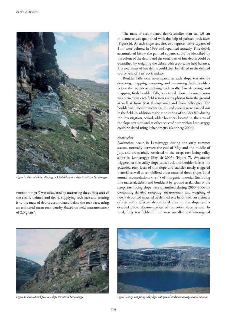
At each slope test site a 40 m2 net (4 x 10 m, 1.5 cm mesh size) was installed with its longer side placed along the rock wall/face foot on the talus cone developed below clearly defined vertical or slightly overhanging rock walls/rock faces (Figure 5). The nets were efficient in collecting debris produced by mechanical weathering at the rock walls and transferred to the net by primary and secondary rock falls (Beylich 1999, 2000b). The collected debris was repeatedly quantified by weighing it with a portable field balance ((kg m-2), (kg m-2 yr-1)). Rock-wall

���
Sediment fluxes and sediment budget in Latnjavagge
Figure 3. Geomorphological map of the Latnjavagge catchment.
Figure 4. (a and b) Slope test site in Latnjavagge.
a b
���
Achim A. Beylich
retreat (mm yr-1) was calculated by measuring the surface area of the clearly defined and debris-supplying rock face and relating it to the mass of debris accumulated below the rock face, using an estimated mean rock density (based on field measurements) of 2.5 g cm-3.
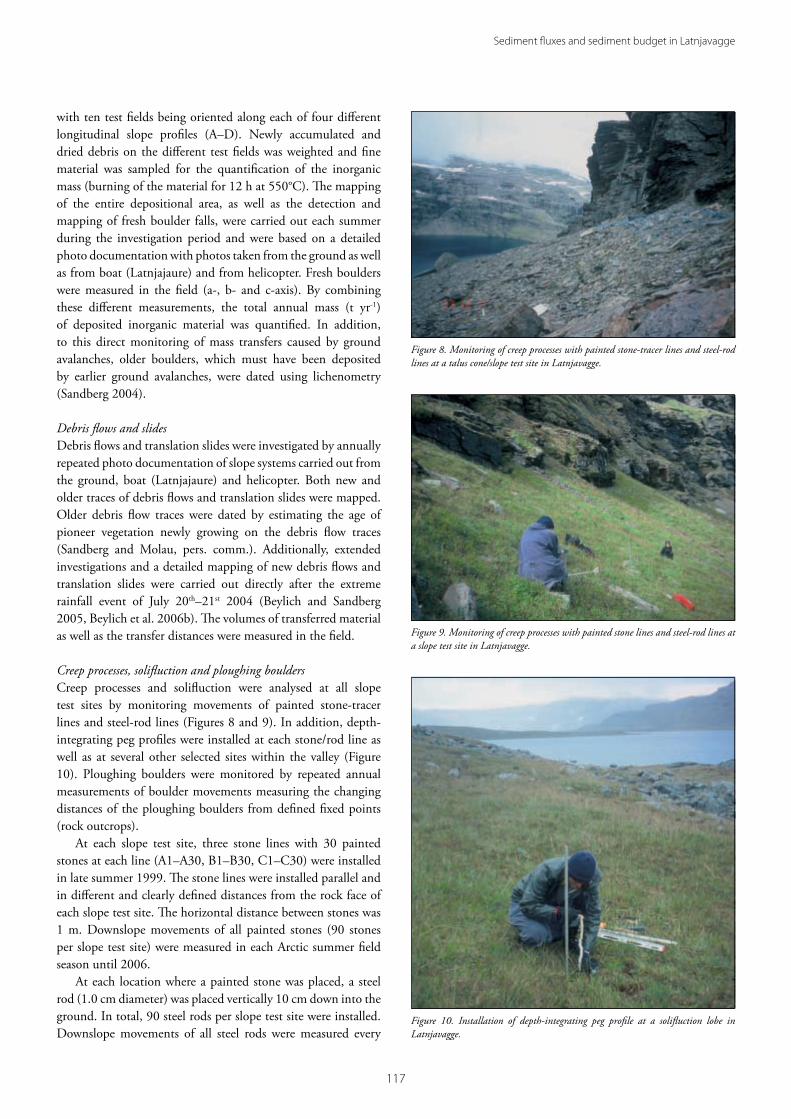
The mass of accumulated debris smaller than ca. 1.0 cm in diameter was quantified with the help of painted rock faces (Figure 6). At each slope test site, two representative squares of 1 m2 were painted in 1999 and repainted annualy. Fine debris accumulated below the painted squares could be identified by the colour of the debris and the total mass of fine debris could be quantified by weighing the debris with a portable field balance. The total mass of fine debris could then be related to the defined source area of 1 m2 rock surface.
Boulder falls were investigated at each slope test site by detecting, mapping, counting and measuring fresh boulders below the boulder-supplying rock walls. For detecting and mapping fresh boulder falls, a detailed photo documentation was carried out each field season taking photos from the ground as well as from boat (Latnjajaure) and from helicopter. The boulder-size measurements (a-, b- and c-axis) were carried out in the field. In addition to the monitoring of boulder falls during the investigation period, older boulders located in the area of the slope test sites and at other selected sites within Latnjavagge could be dated using lichenometry (Sandberg 2004).
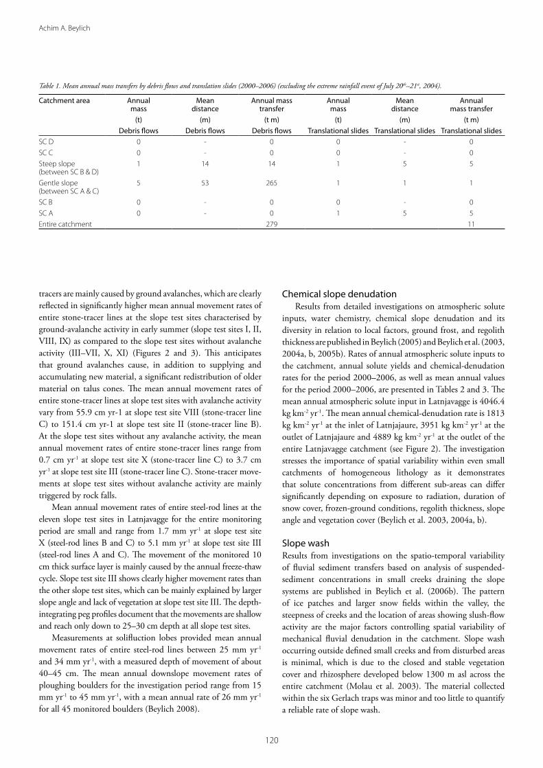
AvalanchesAvalanches occur in Latnjavagge during the early summer season, normally between the end of May and the middle of July, and are spatially restricted to the steep, east-facing valley slope in Latnjavagge (Beylich 2003) (Figure 7). Avalanches triggered at this valley slope cause rock and boulder falls at the extended rock faces of this slope and transfer newly triggered material as well as remobilised older material down slope. Total annual accumulations (t yr-1) of inorganic material (including fine material, debris and boulders) by ground avalanches at the steep, east-facing slope were quantified during 2000–2006 by combining detailed sampling, measurement and weighing of newly deposited material at defined test fields with an estimate of the entire affected depositional area on the slope and a detailed photo documentation of the entire slope system. In total, forty test fields of 1 m2 were installed and investigated
Figure 5. Net, which is collecting rock fall debris at a slope test site in Latnjavagge.
Figure 6. Painted rock face at a slope test site in Latnjavagge Figure 7. Steep, east-facing valley slope with ground-avalanche activity in early summer.
���
Sediment fluxes and sediment budget in Latnjavagge
with ten test fields being oriented along each of four different longitudinal slope profiles (A–D). Newly accumulated and dried debris on the different test fields was weighted and fine material was sampled for the quantification of the inorganic mass (burning of the material for 12 h at 550°C). The mapping of the entire depositional area, as well as the detection and mapping of fresh boulder falls, were carried out each summer during the investigation period and were based on a detailed photo documentation with photos taken from the ground as well as from boat (Latnjajaure) and from helicopter. Fresh boulders were measured in the field (a-, b- and c-axis). By combining these different measurements, the total annual mass (t yr-1) of deposited inorganic material was quantified. In addition, to this direct monitoring of mass transfers caused by ground avalanches, older boulders, which must have been deposited by earlier ground avalanches, were dated using lichenometry (Sandberg 2004).
Debris flows and slidesDebris flows and translation slides were investigated by annually repeated photo documentation of slope systems carried out from the ground, boat (Latnjajaure) and helicopter. Both new and older traces of debris flows and translation slides were mapped. Older debris flow traces were dated by estimating the age of pioneer vegetation newly growing on the debris flow traces (Sandberg and Molau, pers. comm.). Additionally, extended investigations and a detailed mapping of new debris flows and translation slides were carried out directly after the extreme rainfall event of July 20th–21st 2004 (Beylich and Sandberg 2005, Beylich et al. 2006b). The volumes of transferred material as well as the transfer distances were measured in the field.
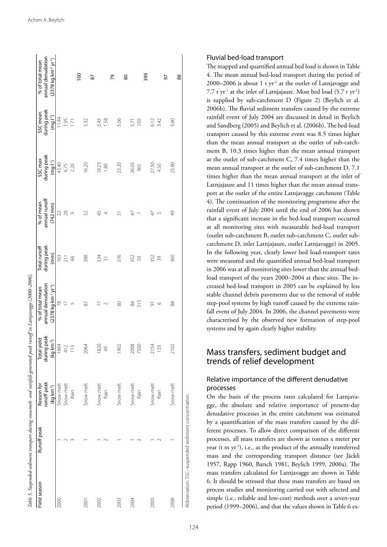
Creep processes, solifluction and ploughing bouldersCreep processes and solifluction were analysed at all slope test sites by monitoring movements of painted stone-tracer lines and steel-rod lines (Figures 8 and 9). In addition, depth-integrating peg profiles were installed at each stone/rod line as well as at several other selected sites within the valley (Figure 10). Ploughing boulders were monitored by repeated annual measurements of boulder movements measuring the changing distances of the ploughing boulders from defined fixed points (rock outcrops).
At each slope test site, three stone lines with 30 painted stones at each line (A1–A30, B1–B30, C1–C30) were installed in late summer 1999. The stone lines were installed parallel and in different and clearly defined distances from the rock face of each slope test site. The horizontal distance between stones was 1 m. Downslope movements of all painted stones (90 stones per slope test site) were measured in each Arctic summer field season until 2006.
At each location where a painted stone was placed, a steel rod (1.0 cm diameter) was placed vertically 10 cm down into the ground. In total, 90 steel rods per slope test site were installed. Downslope movements of all steel rods were measured every
Figure 8. Monitoring of creep processes with painted stone-tracer lines and steel-rod lines at a talus cone/slope test site in Latnjavagge.
Figure 9. Monitoring of creep processes with painted stone lines and steel-rod lines at a slope test site in Latnjavagge.
Figure 10. Installation of depth-integrating peg profile at a solifluction lobe in Latnjavagge.

��8
Achim A. Beylich
year, taking clearly defined and marked points at the stable rock faces as fixed points. Additional steel-rod lines were installed at three solifluction sheets as well as at four solifluction lobes within the valley. At each sheet/lobe, three lines with 15 steel-rods (A1–A15, B1–B15, C1–C15) were installed in the same way as at the eleven slope test sites.
At each of the in total 54 stone lines/steel-rod lines, one depth-integrating peg profile (composed of 17 pieces of 3 cm long plastic rods (1.5 cm diameter)) was installed vertically and 50 cm down into the ground (Figure 10). The downslope movements of the different plastic rod pieces were measured after the entire investigation period and after digging out holes next to the peg profiles.
Downslope movements of in total 45 ploughing boulders at the gently-sloping, west-facing valley slope were monitored by repeated measurements carried out at the end of each Arctic summer field season between 1999 and 2006. Measurements were conducted using a steel tape and two marked points at stable rock outcrops as fixed points for each boulder.
Chemical slope denudationChemical slope denudation was investigated by analysing water samples collected from small creeks and pipes on the slopes of Latnjavagge. Beylich et al. (2003, 2004a, b) published results from studies on water chemistry and its diversity in relation to local factors in the Latnjavagge catchment, including a detailed description of methods. Solute yields and chemical-denudation rates for the Latnjavagge catchment were calculated based on measurements of atmospheric solute inputs to the catchment, runoff and solute concentrations in main creeks (see below).
Slope washThe importance of slope wash was estimated using six Gerlach traps, which were installed at different locations in Latnjavagge. A detailed study of suspended-sediment transport in small creeks draining slope systems, including a description of methods, is published in Beylich et al. (2006b).
Estimating the importance of deflationThe role of deflation was estimated by analysing sediment concentrations in snow cores collected along defined profiles within the valley (Beylich et al. 2006b) and by collecting aeolian deposits in two samplers installed close to the southern shoreline of Latnjajaure (Figure 2).
Quantifying mass transfers by slush flowsMass transfers by slush flows were quantified by a mapping of slush-flow deposits and by estimating the transported volumes and masses as well as the transport distances (Beylich and Gintz 2004, Beylich et al. 2006b).
Monitoring runoff and fluvial transportDischarge in channels was measured three times daily with an Ott-propeller C2 (Ott GmbH & Co. KG, Kempten) immediately
prior to sampling of water (see Beylich 1999, Beylich et al. 2003). The installation of fixed gauge stations was not possible because of the characteristics of the channels (bedrock and/or blocks, shifting channels during snowmelt, high slush-flow frequency and destruction of installations).
Directly after each discharge measurement, vertically integrated water samples were taken with 1000 ml wide-necked polyethylene bottles. The samples were filtered in the laboratory of the Latnjajaure Field Station with a pressure filter and ash-free filter papers. After the field campaigns, the filter papers were burned (12 h, 550°C) to analyse the concentrations of mineralogenic suspended solids (mg l-1). Daily discharge-weighted suspended-sediment concentrations were then calcu-lated by interpolating the measurements (see Beylich 1999, Beylich et al. 2006b). The stability of creeks and channel stone pavements as well as the scale of bed-load transport was estimated using painted stone-tracer lines (Figure 11) at selected creeks and channel stretches (Figure 2). Fresh accumulations of debris/bed load were analysed by weighing of debris and by a detailed measurement of the volumes of fresh deposits (Beylich et al. 2006b). After each discharge measurement, surface-water electrical conductivity, corrected to 25°C, was measured using a portable conductivity meter (Cond 315i/SET, WTW Weilheim) and concentrations of total dissolved solids (mg l-1) were calculated (Beylich et al. 2003).
Rates of denudative slope processes
Relevant denudative slope processes in Latnjavagge are rock falls and boulder falls, ground avalanches, debris flows, translation slides, creep processes and solifluction, ploughing boulders, chemical denudation, and slope wash.
Rock falls and boulder fallsTables with masses of newly accumulated debris (kg m-2) on nets installed below rock faces, corresponding annual rock wall- retreat
Figure 11. Painted stone-tracer line in a creek in Latnjavagge.

���
Sediment fluxes and sediment budget in Latnjavagge
rates (mm) and mean annual rock wall-retreat rates (mm yr-1) for the entire investigation period at the slope test sites I–XI are published in Beylich (2008). The mean annual rock wall-retreat rates vary between 0.096 mm yr-1 at the southwest-exposed slope test site IV and 0.363 mm yr-1 at the southwest-exposed slope test site V (Figure 2). The ratio of the largest recorded annual rate and the smallest annual rate is accordingly 3.8. The mean of all eleven recorded annual rock wall-retreat rates (1999–2006) is 0.216 mm yr-1. Based on field observations, the main factors controlling the spatial variability of mechanical weathering at rock faces, rock falls and rock wall-retreat rates appear to be (i) the density of vertical and horizontal jointing of rock faces and (ii) the availability of moisture. Field observations also showed that daily freeze-thaw cycles, with minimum air temperatures around -10°C, trigger rock falls from snow-free but wet rock walls and rock ledges. Rock-fall activity is caused by both the annual freeze-thaw cycle and by daily freeze-thaw cycles and reaches its highest intensity in May and June. Strong wind gusts and heavy rainfall can trigger secondary rock falls also over the summer (Beylich 2003). On slopes without avalanche activity (see below) boulder falls were only observed in July and August, and were mainly caused by the delayed melting of ice developed in joints deeper within rock walls. Theses boulder falls were triggered by the annual freeze-thaw cycle (Beylich 2003) (Figure 12). The extreme rainfall event of July 2004 triggered secondary rock falls and some boulder falls (Beylich and Sandberg 2005). Single boulder falls can be triggered by direct human impact (Beylich et al. 2005a). The mean annual rock wall-retreat rate caused by boulder falls was calculated to be 0.197 mm yr-1 (Sandberg 2004).
Quantification of fine debris produced at painted rock walls at the eleven slope test sites showed little relevance, with a calculated mean annual rock wall-retreat rate (1999–2006) of 0.024 mm yr-1.
With a given total surface area of 3.15 km2 for rock walls and rock ledges in Latnjavagge (Molau pers. comm.) and a calculated mean annual rock wall-retreat rate of (0.216 + 0.197 + 0.024)
0.437 mm yr-1, the annual volume of material transferred by rock and boulder falls (excluding the rock falls and boulder falls which are triggered by avalanches at the steep and east-facing valley slope, see below) can be estimated to be on the scale of 1376.55 m3, or (given a mean density of 2.5 g cm-3) 3441.38 t.
AvalanchesDetailed tables showing the total annual masses of inorganic material deposited by avalanches during the entire investigation period on talus cones of the steep and east-facing valley slope (Figure 7) are presented in Beylich (2008). The mean annual mass of deposited inorganic material is 69.3 t, which is composed of 57.3% boulders and 42.7% debris and finer material. The largest annual deposition occurred in 2000 (93.3 t) and the smallest in 2006 (43.3 t). Snow-rich winters lead to a higher frequency of avalanches in early summer (end of May until mid-July) and accordingly to larger amounts of deposited inorganic material than do snow-poor winters. The annual mass of accumulated boulders is higher than the annual mass of accumulated debris and finer material. Years with larger masses of accumulated boulders are also characterised by larger annual masses of accumulated debris and finer material.
Debris flows and slidesDebris flows and translation slides in Latnjavagge are triggered by heavy rainfall (Beylich 2003, Beylich and Gintz 2004, Beylich and Sandberg 2005). Annual mass transfers by debris flows and translation slides show a spatial variability within the Latnjavagge catchment. The mean annual mass transfers presented in Table 1 do not include the mass transfers, which were triggered by the extreme rainfall event of July 2004 (Beylich and Sandberg 2005). Comparison of the mean annual mass transfers published in Table 2 in Beylich and Sandberg (2005), with the mean annual mass transfers presented in Table 1 in this paper, reveals that the frequency and intensity of debris flows and translation slides have increased after the extreme rainfall event of July 2004. The increased frequency of debris flows is reflected in an increase in the mean annual mass transfer from 212 t m calculated for the period 2000–2004 to 279 t m quantified for the period 2000–2006. The increased frequency and intensity of translation slides is documented by an increase of the mean annual mass transfer from 2.5 t m calculated for 2000–2004 to 11 t m determined for 2000–2006. The higher frequency and intensity of debris flows and translation slides is a direct consequence of the destabilisation of slope systems and the disturbance of the vegetation cover in areas with debris flow and slide activity during the extreme event of July 2004 (Beylich and Sandberg 2005).
Creep processes, solifluction and ploughing bouldersDetailed tables with mean annual movement rates of stone-tracer lines as monitored at the eleven slope test sites over the investigation period within the Latnjavagge catchment are presented in Beylich (2008). Movements of painted stone Figure 12. Fresh boulder fall in Latnjavagge.
��0
Achim A. Beylich
tracers are mainly caused by ground avalanches, which are clearly reflected in significantly higher mean annual movement rates of entire stone-tracer lines at the slope test sites characterised by ground-avalanche activity in early summer (slope test sites I, II, VIII, IX) as compared to the slope test sites without avalanche activity (III–VII, X, XI) (Figures 2 and 3). This anticipates that ground avalanches cause, in addition to supplying and accumulating new material, a significant redistribution of older material on talus cones. The mean annual movement rates of entire stone-tracer lines at slope test sites with avalanche activity vary from 55.9 cm yr-1 at slope test site VIII (stone-tracer line C) to 151.4 cm yr-1 at slope test site II (stone-tracer line B). At the slope test sites without any avalanche activity, the mean annual movement rates of entire stone-tracer lines range from 0.7 cm yr-1 at slope test site X (stone-tracer line C) to 3.7 cm yr-1 at slope test site III (stone-tracer line C). Stone-tracer move-ments at slope test sites without avalanche activity are mainly triggered by rock falls.
Mean annual movement rates of entire steel-rod lines at the eleven slope test sites in Latnjavagge for the entire monitoring period are small and range from 1.7 mm yr-1 at slope test site X (steel-rod lines B and C) to 5.1 mm yr-1 at slope test site III (steel-rod lines A and C). The movement of the monitored 10 cm thick surface layer is mainly caused by the annual freeze-thaw cycle. Slope test site III shows clearly higher movement rates than the other slope test sites, which can be mainly explained by larger slope angle and lack of vegetation at slope test site III. The depth-integrating peg profiles document that the movements are shallow and reach only down to 25–30 cm depth at all slope test sites.
Measurements at solifluction lobes provided mean annual movement rates of entire steel-rod lines between 25 mm yr-1 and 34 mm yr-1, with a measured depth of movement of about 40–45 cm. The mean annual downslope movement rates of ploughing boulders for the investigation period range from 15 mm yr-1 to 45 mm yr-1, with a mean annual rate of 26 mm yr-1 for all 45 monitored boulders (Beylich 2008).
Chemical slope denudationResults from detailed investigations on atmospheric solute
inputs, water chemistry, chemical slope denudation and its diversity in relation to local factors, ground frost, and regolith thickness are published in Beylich (2005) and Beylich et al. (2003, 2004a, b, 2005b). Rates of annual atmospheric solute inputs to the catchment, annual solute yields and chemical-denudation rates for the period 2000–2006, as well as mean annual values for the period 2000–2006, are presented in Tables 2 and 3. The mean annual atmospheric solute input in Latnjavagge is 4046.4 kg km-2 yr-1. The mean annual chemical-denudation rate is 1813 kg km-2 yr-1 at the inlet of Latnjajaure, 3951 kg km-2 yr-1 at the outlet of Latnjajaure and 4889 kg km-2 yr-1 at the outlet of the entire Latnjavagge catchment (see Figure 2). The investigation stresses the importance of spatial variability within even small catchments of homogeneous lithology as it demonstrates that solute concentrations from different sub-areas can differ significantly depending on exposure to radiation, duration of snow cover, frozen-ground conditions, regolith thickness, slope angle and vegetation cover (Beylich et al. 2003, 2004a, b).
Slope washResults from investigations on the spatio-temporal variability of fluvial sediment transfers based on analysis of suspended-sediment concentrations in small creeks draining the slope systems are published in Beylich et al. (2006b). The pattern of ice patches and larger snow fields within the valley, the steepness of creeks and the location of areas showing slush-flow activity are the major factors controlling spatial variability of mechanical fluvial denudation in the catchment. Slope wash occurring outside defined small creeks and from disturbed areas is minimal, which is due to the closed and stable vegetation cover and rhizosphere developed below 1300 m asl across the entire catchment (Molau et al. 2003). The material collected within the six Gerlach traps was minor and too little to quantify a reliable rate of slope wash.
Table 1. Mean annual mass transfers by debris flows and translation slides (2000–2006) (excluding the extreme rainfall event of July 20th–21st, 2004).
Catchment area Annual mass
Mean distance
Annual mass transfer
Annual mass
Mean distance
Annual mass transfer
(t) (m) (t m) (t) (m) (t m)Debris flows Debris flows Debris flows Translational slides Translational slides Translational slides
SC D 0 - 0 0 - 0SC C 0 - 0 0 - 0Steep slope (between SC B & D)
� �� �� � � �
Gentle slope (between SC A & C)
� �� ��� � � �
SC B 0 - 0 0 - 0SC A 0 - 0 � � �Entire catchment ��� ��

���
Sediment fluxes and sediment budget in Latnjavagge
Table 2. Annual atmospheric solute inputs in Latnjavagge (1999–2006).
Total period Sub-period Sampling Number of samples Concentration of diss. solids (mg l-1)
Total precipitation (mm)
Atmospheric solute input (kg km-2)
0�.�0.���� –
�0.0�.�000
0�.�0.���� –
��.0�.�000
Snow cores (taken in May/June)
�0 Mean: �.�� Max: �.� Min: �.�
���.� ����.�
0�.0�.�000 –
�0.0�.�000
Precipitation (gauge at LFS)
�� Mean: �.�� Max: ��.8 Min: �.�
�0�.8 �8��.�
Total:4565.9
0�.�0.�000 –
�0.0�.�00�
0�.�0.�000 –
��.0�.�00�
Snow cores (taken in May/June)
�� Mean: �.�� Max. �.� Min. �.�
���.� ����.�
0�.0�.�00� –
�0.0�.�00�
Precipitation (gauge at LFS)
�8 Mean: �.8� Max: ��.8 Min: �.�
���.� ��8�.�
Total:2882.0
0�.�0.�00� –
�0.0�.�00�
0�.�0.�00� –
��.0�.�00�
Snow cores (taken in May/June)
�� Mean: �.8� Max: ��.8 Min: �.�
��8.� ���8.�
0�.0�.�00� –
�0.0�.�00�
Precipitation (gauge at LFS)
- Mean: �.�� (mean of �000
and �00�)
���.� ����.�
Total:4280.7
0�.�0.�00� –
�0.0�.�00�
0�.�0.�00� –
��.0�.�00�
Snow cores (taken in May/June)
�� Mean: �.�8 Max: �.� Min: �.�
���.� ����.�
0�.0�.�00� –
�0.0�.�00�
Precipitation (gauge at LFS)
�� Mean: �.8� Max: ��.0 Min: �.�
���.� ����.�
Total:4043.8
0�.�0.�00� –
�0.0�.�00�
0�.�0.�00� –
��.0�.�00�
Snow cores �0 Mean: �.�� Max: �.0 Min: �.�
�8�.� ����.�
0�.0�.�00� –
�0.0�.�00�
Precipitation �� Mean: �.8� Max: ��.� Min: �.8
�0�.� ����.�
Total:4673.1
0�.�0.�00� –
�0.0�.�00�
0�.�0.�00� –
��.0�.�00�
Snow cores �� Mean: �.�� Max: �.0 Min: �.�
�0�.� �0�.�
0�.0�.�00� –
�0.0�.�00�
Precipitation �� Mean: �.�� Max: �.� Min: �.�
�0�.� �0�.�
Total:3985.1
0�.�0.�00� –
�0.0�.�00�
0�.�0.�00� –
��.0�.�00�
Snow cores �� Mean: �.�� Max: �.� Min: �.0
���.� ����.�
0�.0�.�00� –
�0.0�.�00�
Precipitation �� Mean: �.8� Max: ��.� Min: �.�
���.0 ��0�.�
Total:3895.2
0�.�0.���� –
�0.0�.�00�
Mean annual total:input
4046.4
Abbreviation: LFS–Latnjajaure Field Station.

���
Achim A. Beylich
DeflationConcentrations of inorganic solids in snow cores collected along different selected profiles within Latnjavagge (Figure 2) documented that deflation takes place to a certain degree in areas with destroyed, disturbed or stressed vegetation cover, especially if these areas show no closed snow cover in winter due to an aeolian redistribution of snow (Beylich 2003, Beylich et al. 2006b). Because of the obvious dominance of areas with closed and stable vegetation cover, the importance of deflation with respect to sediment transfers is altogether little in Latnjavagge. This is also underlined by very small (negligible) amounts of inorganic material collected in two samplers installed during each Arctic summer season (2000–2006) at the southern shoreline of the Latnjajaure.
Slush flows
Annual numbers of slush flows, the location of triggered slush flows within Latnjavagge, annually accumulated masses, transport distances and annual mass transfers by slush flows are discussed in detail in Beylich (2008). Triggering of slush flows is favoured in years that are characterised by significant snow melt periods during winter, which can lead to clearly defined ice layers within the winter snow pack (Molau pers. comm.). The years 2000–2002 as well as 2004 and 2005 were characterised by several small slush flows occurring in clearly defined areas within the catchment (Beylich et al. 2006b). There were no slush flows occurring in the years 2003 and 2006. In 1999, a mega slush-flow event was triggered in the upper valley by a melt-water outbreak from the uppermost small lake in Latnjavagge (Beylich et al. 2006b). This single mega slush-flow event caused a mass transfer of ca. 375,000 t m, with this mass transfer being 97 times higher than the mean annual total mass transfer as caused by more frequent smaller slush flows. Slush flows deliver fine and coarse material as well as large blocks. Aeolian, wash and fluvial processes transport part of the fine material further. In addition, the mega slush-flow event of 1999 removed the vegetation cover on several moraine ridges above the delta of Latnjajaure, which caused an increased intensity of deflation in the following years in these areas (Beylich et al. 2006b).
Fluvial transport
Fluvial solute transport, suspended-sediment transport, bed-load transport as well as yields of solutes and suspended sediments were quantified for the runoff seasons of 2000–2006 at the inlet and outlet of Latnjajaure and at the outlet of the entire Latnjavagge catchment. The extreme rainfall event of July 2004, with 58.4 mm of rain in 24 h and 71.7 mm of rain in 48 h, was excluded from the calculation of the mean annual transport rates and yields presented in Tables 3 and 4.
Fluvial solute transportFluvial solute transport and its spatio-temporal variability in Latnjavagge are discussed in detail in Beylich (2005) and Beylich et al. (2003, 2004a, b, 2005b). The mean annual chemical-denudation rate at the outlet of the entire Latnjavagge catchment (period 2000–2006) is 4889 kg km-2 yr-1 (Table 3). The mean annual discharge-weighted concentration of total dissolved solids shows only a minimum inter-annual variability, with a maximum of 12.16 mg l-1 in 2003, a minimum of 11.92 mg l-1 in 2000 and a mean annual of 12.04 mg l-1 for the entire investigation period.
Fluvial suspended-sediment transportFluvial suspended-sediment transport and its spatio-temporal variability, the quantitative importance of snowmelt- and rainfall-generated runoff peaks for annual suspended-sediment transport, as well as the suspended-sediment transport during the extreme rainfall event of July 2004, are discussed in detail in Beylich and Gintz (2004), Beylich and Sandberg (2005), Beylich et al. (2005b) and Beylich et al. (2006b). The continuation of the monitoring programme after this event of July 2004, until the end of 2006, has revealed that the suspended-sediment transport at the inlet of Latnjajaure in 2005 was higher than in the years before (2000–2004) and in 2006, and accordingly clearly higher than the mean annual value calculated for the seven-year period 2000–2006 (excluding the extreme rainfall event of July 2004). Annual runoff, annual yields of suspended sediments and mean discharge-weighted suspended-sediment concentrations for the period 2000–2006, as well as the mean annual values for this seven-year period (excluding the rainfall event of July 2004) are shown for the measuring sites inlet Latnjajaure, outlet Latnjajaure and outlet entire Latnjavagge catchment in Table 3. The mean annual yield of suspended sediments is about 2.4 t km-2 yr-1 at the inlet of Latnjajaure, about 0.2 t km-2 yr-1 at the outlet of Latnjajaure, and about 0.6 t km-2 yr-1 at the outlet of the entire Latnjavagge catchment. During the extreme rainfall event of July 2004, the suspended-sediment transport at the inlet of Latnjajaure was 3.2 times higher than the mean annual suspended-sediment transport at this measuring site (Beylich and Sandberg 2005, Beylich et al., 2006b). The snowmelt- and rainfall-generated runoff peaks of the year 2005, as well as the snowmelt-generated peak runoff of the year 2006, show slightly higher suspended-sediment concentrations than hydrologically comparable seasonal peak-runoff events of the years before (Table 5). For the year 2005, this can be explained by the significantly higher intensity of slush flows and the higher mobility of channel debris pavements (see Table 4). In 2005 and 2006, the disturbance of the vegetation cover caused by debris flows and translation slides triggered during the extreme rainfall event of July 2004, is reflected by an increased intensity of slope wash (see Table 3). The significantly higher annual suspended-sediment transport in 2005 as compared to the years 2000–2004 and 2006, is caused by a combination of increased slush-flow activity, increased bed-load transport and debris-pavement mobility as well as increased slope wash.

���
Sediment fluxes and sediment budget in Latnjavagge
Table 3. Annual suspended-sediment yields and annual chemical-denudation rates in Latnjavagge (2000–2006).
Field season Catchment Precipitation (mm)
Runoff (mm)
Yield of sus-pended solids
(kg km-2)
Mean weighted SSC
(mg l-1)
Yield of dissolved solids
(kg km-2)
Mean weighted TDS
(mg l-1)
Chemical denudation
(kg km-2)
�000 Latnjavagge ��� ��� ��� 0.�� 8�8� ��.��
Outlet lake ��� ��� 0.�� 8��� ��.��
Inlet lake ��0 ��8� �.�8 ���� 8.��
�00� Latnjavagge ��� ��8 ���� �.�8 �08� ��.��
Outlet lake ��� ��� 0.�� 80�� �0.��
Inlet lake ��� ��8
�00� Latnjavagge ��8 ��8 ��� �.0� ���� ��.0�
Outlet lake ��0 �0� 0.�� �08� �0.�0
Inlet lake ��� �0�� �.�� ���� �.8�
�00� Latnjavagge ��� ��� �0� 0.�� 80�� ��.��
Outlet lake ��0 ��� 0.�� ���� ��.0�
Inlet lake ��� ���� �.�� ���0 �.�0
�00� (excluding the rare event July �0th–��st)
Latnjavagge ��0 ��8 ��� 0.�8 ��0� ��.0�
Outlet lake 80� ��� 0.�� 80�0 �0.00
Inlet lake 8�� ���� �.�0 ���� �.�0
�00� Latnjavagge ��� ��� ��8 0.�� 8��� ��.00
Outlet lake ��0 �88 0.�� ���� �0.80
Inlet lake ��� ��0� �.�0 ���� �.��
�00� Latnjavagge ��� ��� ��� 0.�� 8��0 ��.0�
Outlet lake ��0 �08 0.�8 8��� �0.�0
Inlet lake ��� ���0 �.0� ��80 �.��
Mean annual values for �000–�00�
Latnjavagge ��� ��� 0.8� 8��� ��.0� �88�
Outlet lake ��� ��� 0.�� ���� �0.�8 ����
Inlet lake ��� ���8 �.�� �8�� �.�0 �8��
Abbreviations: TDS–total dissolved solids, SSC–suspended-sediment concentration.
Table 4. Annual bed-load transport in Latnjavagge (2000–2006).
Site 2000 2001 2002 2003 2004 2005 2006 Mean 2000–2006
Event July 20th–21st, 2004
Outlet SC A 0.00 0.00 0.00 0.00 0.00 0.00 0.00 0.00 0.00
Outlet SC B 0.0� 0.0� 0.0� 0.0� 0.0� 0.�0 0.0� 0.0� 0.��
Outlet SC C 0.0� 0.08 0.08 0.0� 0.08 0.�� 0.0� 0.0� 0.��
Outlet SC D �.0 �.� �.� �.� �.� �.8 �.� �.�� ��
Inlet Latnjajaure
8.� �.� �.� �.0 �.� ��.� �.� �.� ��
Outlet Latnjajaure
0.0 0.0 0.0 0.0 0.0 0.0 0.0 0.0 0
Outlet Latnjavagge
�.� 0.� �.0 0.� �.� �.8 0.� �.0 ��
���
Achim A. Beylich
Fluvial bed-load transportThe mapped and quantified annual bed load is shown in Table 4. The mean annual bed-load transport during the period of 2000–2006 is about 1 t yr-1 at the outlet of Latnjavagge and 7.7 t yr-1 at the inlet of Latnjajaure. Most bed load (5.7 t yr-1) is supplied by sub-catchment D (Figure 2) (Beylich et al. 2006b). The fluvial sediment transfers caused by the extreme rainfall event of July 2004 are discussed in detail in Beylich and Sandberg (2005) and Beylich et al. (2006b). The bed-load transport caused by this extreme event was 8.5 times higher than the mean annual transport at the outlet of sub-catch-ment B, 10.3 times higher than the mean annual transport at the outlet of sub-catchment C, 7.4 times higher than the mean annual transport at the outlet of sub-catchment D, 7.1 times higher than the mean annual transport at the inlet of Latnjajaure and 11 times higher than the mean annual trans-port at the outlet of the entire Latnjavagge catchment (Table 4). The continuation of the monitoring programme after the rainfall event of July 2004 until the end of 2006 has shown that a significant increase in the bed-load transport occurred at all monitoring sites with measurable bed-load transport (outlet sub-catchment B, outlet sub-catchment C, outlet sub-catchment D, inlet Latnjajaure, outlet Latnjavagge) in 2005. In the following year, clearly lower bed load-transport rates were measured and the quantified annual bed-load transport in 2006 was at all monitoring sites lower than the annual bed-load transport of the years 2000–2004 at these sites. The in-creased bed-load transport in 2005 can be explained by less stable channel debris pavements due to the removal of stable step-pool systems by high runoff caused by the extreme rain-fall event of July 2004. In 2006, the channel pavements were characterised by the observed new formation of step-pool systems and by again clearly higher stability.
Mass transfers, sediment budget and trends of relief development
Relative importance of the different denudative processesOn the basis of the process rates calculated for Latnjava-gge, the absolute and relative importance of present-day denudative processes in the entire catchment was estimated by a quantification of the mass transfers caused by the dif-ferent processes. To allow direct comparison of the different processes, all mass transfers are shown as tonnes x meter per year (t m yr-1), i.e., as the product of the annually transferred mass and the corresponding transport distance (see Jäckli 1957, Rapp 1960, Barsch 1981, Beylich 1999, 2000a). The mass transfers calculated for Latnjavagge are shown in Table 6. It should be stressed that these mass transfers are based on process studies and monitoring carried out with selected and simple (i.e., reliable and low-cost) methods over a seven-year period (1999–2006), and that the values shown in Table 6 ex-Ta
ble 5
. Sus
pend
ed-se
dim
ent t
rans
port
dur
ing
snow
melt
- and
rain
fall-
gene
rate
d pe
ak ru
noff
in L
atnj
avag
ge (2
000–
2006
).
Fiel
d se
ason
Runo
ff pe
ak
Reas
on fo
r ru
noff
peak
Tota
l yie
ld
durin
g pe
ak%
of t
otal
mea
n an
nual
den
udat
ion
Tota
l run
off
durin
g pe
ak%
of m
ean
an
nual
runo
ffSS
C m
ax
durin
g pe
akSS
C m
ean
du
ring
peak
% o
f tot
al m
ean
an
nual
den
udat
ion
(kg
km-2
)(k
g km
-2)
(237
8 kg
km
-2 y
r-1)
(mm
)(7
42 m
m)
(mg
l-1)
(mg
l-1)
(237
8 kg
km
-2 y
r-1)
�000
�Sn
ow m
elt
�8��
�8��
���
��.�
0��
.��
�Sn
ow m
elt
���
����
��8
�.��
�.��
�Ra
in��
��
���
�.�0
�.��
100
�00�
�Sn
ow m
elt
�0��
8��8
8��
��.�
0�.
��87
�00�
�Sn
ow m
elt
�8�0
����
���
�8.�
��.
���
Rain
���
���
�.80
�.�8
79�0
0��
Snow
mel
t��
0�80
���
����
.�0
�.0�
80�0
0��
Snow
mel
t�0
088�
���
����
.0�
�.��
�Ra
in��
00��
��0
���
���
039
9�0
0��
Snow
mel
t��
����
���
����
.�0
�.��
�Ra
in��
��
���
�.�0
�.��
97�0
0��
Snow
mel
t��
0�88
��0
����
.�0
�.80
88
Abbr
evia
tion:
SSC
–sus
pend
ed se
dim
ent c
once
ntra
tion.

���
Sediment fluxes and sediment budget in Latnjavagge
clude the geomorphic effects of the rare rainfall event of July 2004 (Beylich and Sandberg 2005) and of the mega slush-flow event of May 1999. The role of these extreme events is further discussed below. In computing the mass transfers caused by rock- and boulder falls, the following assumptions were made: a total debris-supplying rock-wall and rock-ledge surface of 3.15 km2, a mean annual rock wall-retreat rate of 0.44 mm yr-1, an average transport distance of 7.5 m and an average rock density of 2.5 g cm-3. Also, the material transported and deposited by ground avalanches was presumed to have an average density of 2.5 g cm-
3. Calculating the mass transfer caused by creep and solifluction was led by the following assumptions: an affected surface of 2.8 km2, an average movement rate of 0.003 m yr-1 in a 0.3 m-thick layer, and an average material density of 2.0 g cm-3. In contrast to the other denudative processes, chemical denudation affects the total surface of the slope systems. The transport distance of 500 m is about half the medium distance between water divide and main channel.
The transport distance of 2300 m for fluvial solute transport is about half the medium distance between the water divide opposite to the outlet and the catchment outlet. Mass transfers by fluvial suspended-sediment transport and fluvial bed-load transport are based on an average movement of 1400 m for suspended sediments, which is about half the medium distance between the water divide and inlet Latnjajaure, and 250 m for bed load, based on monitoring of tracer movements. Fluvial solute transport clearly dominates over fluvial sediment transport.
Ranking the different processes according to their annual mass transfers shows that stream work dominates over slope denudation, with fluvial solute transport being clearly the most important process.
Ranking the different processes according to their annual mass transfers shows that rock falls plus boulder falls is the most important factor in slope denudation, followed by chemical denudation. As a result, according to their relative importance, the different processes can be ranked as follows: (1) Fluvial
solute transport, (2) Fluvial suspended-sediment transport plus fluvial bed-load transport, (3) Rock falls and boulder falls, (4) Chemical slope denudation, (5) Mechanical fluvial slope denudation, (6) Avalanches, (7) Creep and solifluction, (8) Slush flows, (9) Debris flows, (10) Translation slides, and (11) Deflation.
With respect to the temporal variability of process intensities and/or process frequencies, the main snow-melt period (late May–June/July), which is characterised by high runoff, increased fluvial transport, slush-flow activity, avalanches and rock and boulder falls, as well as August, which is the month showing the highest frequency of extreme rainfall events (Beylich 2003, Beylich and Gintz 2004) triggering debris flows, translation slides, secondary rock falls, boulder falls, peak runoff and increased fluvial transport, can be pointed out as periods with comparatively high activity of denudative processes. In comparision, the period from late October until early May is characterised by only very little (single avalanches) or no activity of denudative processes.
The importance of the July 2004 rainfall and May 1999 extreme slush-flow events
On July 20th–21st 2004, an extreme rainfall event, with 58.4 mm of rain in 24 h and 71.7 mm of rain in 48 h, as measured at the weather station of the Latnjajaure Field Station, occurred (Beylich and Sandberg 2005). This extreme rainfall event is considered a ‘rare event’ (Beylich 2003), which caused extreme peak runoff in the fluvial systems of the Abisko mountain area and significant damage to the road between Abisko and Kiruna (Beylich and Sandberg 2005). The rare rainfall event triggered high sediment transfers on the slopes and in the fluvial systems of the Latnjavagge drainage basin, and the quantified mass transfers at only one day during this extreme rainfall event exceeded the mean annual mass transfers calculated for the seven-year period 1999–2006 (and excluding the rare rainfall event of July 2004) by several times (see Beylich and Sandberg 2005, Beylich et al. 2006b). The rare rainfall event caused several debris flows,
Table 6. Annual mass transfers by the different denudative processes in Latnjavagge, based on field measurements carried out between 1999 and 2006.
Process Volume (m3 yr-1)
Mass (t yr-1)
Area (km2)
Mass/Area (t km-2 yr-1)
Average movement (m)
Mass transfer (t m yr-1)
Slope denudation Rockfalls and boulder falls ���� ���� �.�� �0�� �.� ��,808Ground avalanches �8 �� 0.0� ���0 ��0 �0��0Debris flows � � 0.0000�� ���,000 �� ���Translational slides �.� � 0.0000�� ���,��� �.� ��Creep and solifluction 8�0,000 �,�80,000 �.8 �00,000 0.00� �0�0Chemical denudation �� �� � �.� �00 ��,000Mechanical fluvial denudation �0.� �� � �.� �00 �0,�00Deflation little littleSlush flows ��.� �0.� 0.0000�� ���,�0� �08.� ��0�
Stream work Solute transport �� �� � �.� ��00 �0�,�00Suspended-sediment transport �0.� �� � �.� ��00 ��,�00Bed-load transport �.� �-� 0.0� ���.� ��0 ����
���
Achim A. Beylich
translation slides, boulder falls, secondary rock falls, locally very high slope wash, bank erosion in creeks above the Latnjajaure delta and high suspended-sediment and bed-load transport in creeks. Table 2 in Beylich and Sandberg (2005, page 415) provides mass transfers (t m) by debris flows, translation slides and fluvial debris transport in creeks and channels, which were caused in different parts of the Latnjavagge catchment by the July 2004 rainfall event. The mass transfers triggered by the rare event can be discussed in direct comparison with the mean annual mass transfers calculated for the period 1999–2006 (and excluding the extreme rainfall event) (see Table 1). The mass transfer by debris flows, which were triggered during the rare rainfall event, was 2030 t m in the entire Latnjavagge catchment, which is 7.3 times higher than the mean annual mass transfer by debris flows (279 t m). It has to be noted that the annual mass transfers by debris flows have clearly increased after the July 2004 event, which is also reflected in significantly higher mean annual mass transfer for the period 2000–2006 (279 t m) as compared to the mean annual mass transfer for the five-year period 2000–2004 (212 t m). The mass transfer by translation slides that were triggered during the rare event reached 2446 t m in the entire catchment, which is 222.4 times higher than the mean annual mass transfer by slides (11 t m). It is again necessary to stress that also the annual mass transfers caused by translation slides have clearly increased after the July 2004 rare rainfall event, which is documented by a significantly higher mean annual mass transfer for the seven-year period 2000–2006 (11 t m) as compared to the five-year period 2000–2004 (2.5 t m). The total mass transfer by fluvial debris transport in creeks and channels during the rare rainfall event was 7480 t m, which is 16.9 times higher than the corresponding mean annual mass transfer within the entire Latnjavagge catchment, quantified to be 444 t m for the period 2000–2004 (Beylich and Sandberg 2005).
During the rare event, the mass transfer by fluvial debris transport in creeks and channels (7480 t m) had clearly the highest relative importance, followed by mass transfers by slides (2446 t m) and debris flows (2030 t m). In comparision, the mean annual mass transfers (excluding the July 2004 event) again show a relative dominance of fluvial debris transport in creeks, but are followed by debris flows whereas translation slides are of only minor importance.
During the rare rainfall event, the mass transfers caused by debris flows, translation slides and fluvial debris transport, as well as suspended-sediment transport, were several times higher than the mean annual mass transfers.
The mega slush-flow event of May 1999 caused a mass transfer that was 97 times higher than the mean annual total mass transfer caused by several small slush flows between 2000 and 2006.
Both the rare rainfall event of July 2004 and the mega slush-flow event of May 1999 underline the high importance of rare events for the calculation of longer-term sediment budgets. Both rare events also reveal the difficulties of defining an adequate
length for monitoring programmes (Beylich and Sandberg 2005).
Comparing the results from Latnjavagge with data collected in other cold-environment catchments shows some similarities but also some significant differences to other areas. Rapp (1960) stressed in his seminal study of denudation and slope development in Kärkevagge, northernmost Swedish Lapland, the high importance of chemical weathering and denudation, and his work stands out as the study that opened awareness of chemical denudation in cold environments. His findings for Kärkevagge and a high relative importance of chemical weathering and denudation were confirmed by later investigations carried out in this valley (Dixon et al. 1995, 2001, 2005, 2008, Darmody et al. 2000, 2001, Campbell et al. 2001, 2002, Thorn et al. 2001, 2006) and have also been postulated for other cold environments (e.g., Semmel 1969, Lewkowicz 1983, Åkermann 1983, French 1996). In comparision and in accordance with findings in Latnjavagge, slope-wash processes are of only little importance in Kärkevagge (Rapp 1960, Strömquist and Rehn 1981). A significant difference between the mass transfers calculated for Latnjavagge and the mass transfers published by Rapp (1960) is the high importance of slides and debris flows in Kärkevagge. The high importance of slides and debris flows found by Rapp (1960) is based mainly on mass transfers which were triggered by a rare rainfall event with 107 mm in 24 h and 175 mm in 72 h in October 1959. This rare event occurred at the end of Rapp`s nine-year investigation period (1952–1960) and the mean annual mass transfers caused by slides and debris flows as calculated by Rapp might actually be too high, given the long recurrence intervals of such rare rainfall events in northernmost Swedish Lapland (Beylich 1999, 2003, see also French 1996). The problem of defining an adequate length of monitoring programmes becomes, as in Latnjavagge with respect to the rare rainfall event of July 2004 and the mega slush-flow event of May 1999, again obvious (Beylich and Sandberg 2005).
Barsch (1981) found, in accordance with the results from Latnjavagge, a relative dominance of fluvial transport over slope processes for the Oobloyah Valley in northern Ellesmere Island (Northwest Territories, Canada). Rock falls and slope wash have the largest relative importance at the slope systems in this valley (Barsch 1981).
Beylich (1999, 2000a, b) pointed out that regarding annual mass transfers, fluvial transport dominates over slope processes in the very steep Austdalur catchment in east Iceland. Due to human impact and the connected disturbance and partly removal of the vegetation cover, fluvial sediment transport dominates over fluvial solute transport. At the slope systems, slope wash has, similar to the Oobloyah Valley in northern Ellesmere Island (Barsch 1981), but in clear contrast to Kärkevagge (Rapp 1960) and Latnjavagge, the largest relative importance and is followed by chemical denudation, ground avalanches, rock falls and boulder falls, creep processes, debris slides and flows, and deflation.
In all four study areas in sub-Arctic, oceanic east Iceland,
���
Sediment fluxes and sediment budget in Latnjavagge
high-Arctic, continental northern Ellesmere Island, and sub-Arctic, oceanic to Arctic oceanic Swedish Lapland, the intensity of present-day denudative processes is altogether rather low, which is contrary to the earlier postulated (e.g., Tricart 1970, Büdel 1981) high intensity of geomorphic processes in cold environments.
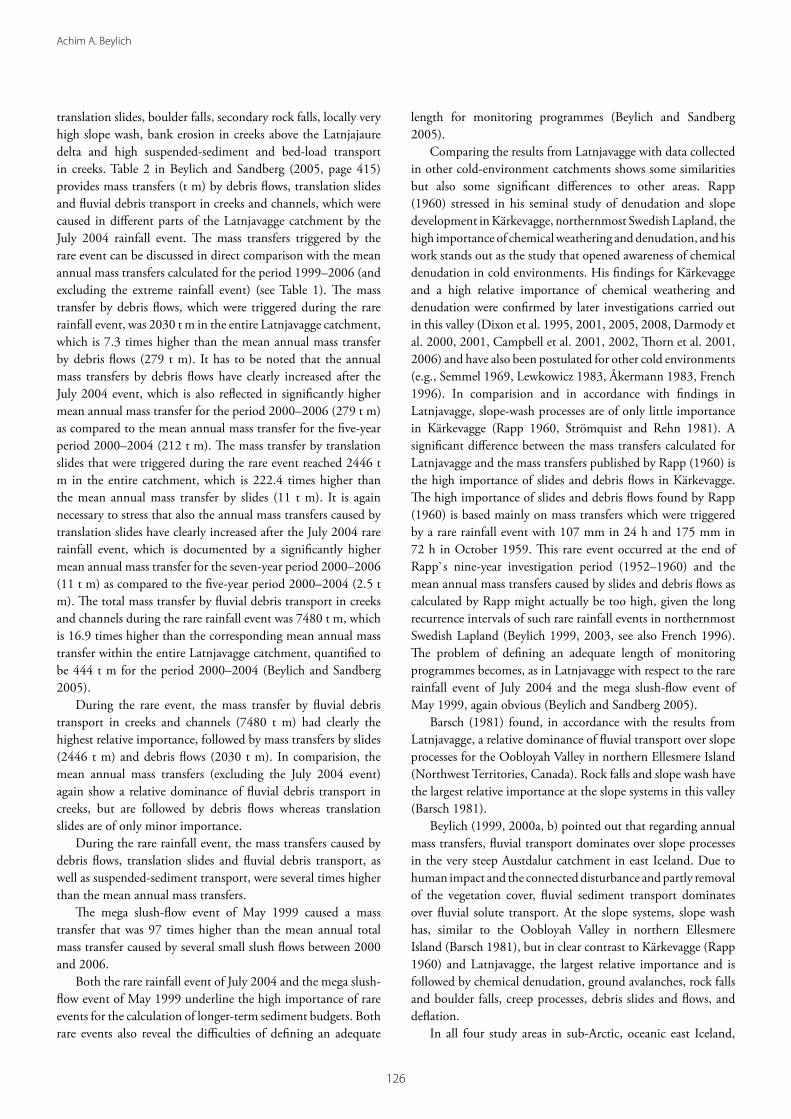
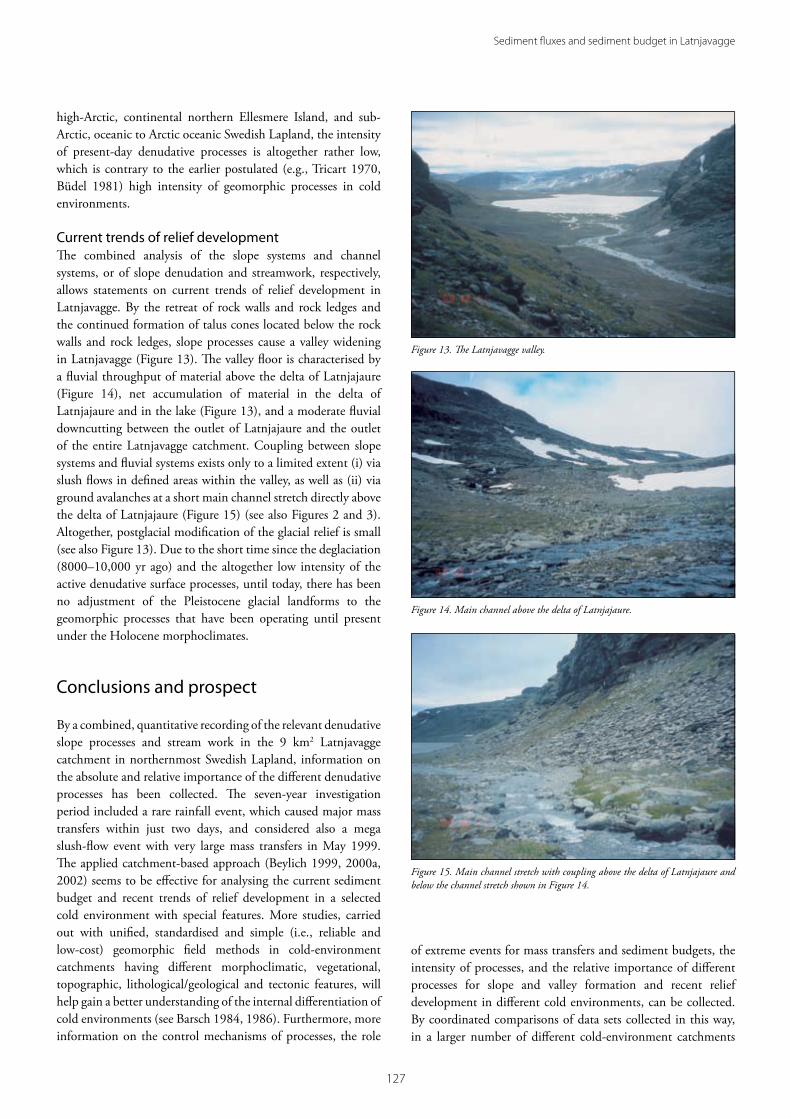
Current trends of relief developmentThe combined analysis of the slope systems and channel systems, or of slope denudation and streamwork, respectively, allows statements on current trends of relief development in Latnjavagge. By the retreat of rock walls and rock ledges and the continued formation of talus cones located below the rock walls and rock ledges, slope processes cause a valley widening in Latnjavagge (Figure 13). The valley floor is characterised by a fluvial throughput of material above the delta of Latnjajaure (Figure 14), net accumulation of material in the delta of Latnjajaure and in the lake (Figure 13), and a moderate fluvial downcutting between the outlet of Latnjajaure and the outlet of the entire Latnjavagge catchment. Coupling between slope systems and fluvial systems exists only to a limited extent (i) via slush flows in defined areas within the valley, as well as (ii) via ground avalanches at a short main channel stretch directly above the delta of Latnjajaure (Figure 15) (see also Figures 2 and 3). Altogether, postglacial modification of the glacial relief is small (see also Figure 13). Due to the short time since the deglaciation (8000–10,000 yr ago) and the altogether low intensity of the active denudative surface processes, until today, there has been no adjustment of the Pleistocene glacial landforms to the geomorphic processes that have been operating until present under the Holocene morphoclimates.
Conclusions and prospect
By a combined, quantitative recording of the relevant denudative slope processes and stream work in the 9 km2 Latnjavagge catchment in northernmost Swedish Lapland, information on the absolute and relative importance of the different denudative processes has been collected. The seven-year investigation period included a rare rainfall event, which caused major mass transfers within just two days, and considered also a mega slush-flow event with very large mass transfers in May 1999. The applied catchment-based approach (Beylich 1999, 2000a, 2002) seems to be effective for analysing the current sediment budget and recent trends of relief development in a selected cold environment with special features. More studies, carried out with unified, standardised and simple (i.e., reliable and low-cost) geomorphic field methods in cold-environment catchments having different morphoclimatic, vegetational, topographic, lithological/geological and tectonic features, will help gain a better understanding of the internal differentiation of cold environments (see Barsch 1984, 1986). Furthermore, more information on the control mechanisms of processes, the role
of extreme events for mass transfers and sediment budgets, the intensity of processes, and the relative importance of different processes for slope and valley formation and recent relief development in different cold environments, can be collected. By coordinated comparisons of data sets collected in this way, in a larger number of different cold-environment catchments
Figure 13. The Latnjavagge valley.
Figure 14. Main channel above the delta of Latnjajaure.
Figure 15. Main channel stretch with coupling above the delta of Latnjajaure and below the channel stretch shown in Figure 14.

��8
Achim A. Beylich
of similar size (ca. 10–30 km2), larger, integrated studies on the effects of projected climate change and on relief and landform development in cold environments can be realised (Beylich 1999, 2000a, 2007, Beylich and Warburton 2007, Beylich et al. 2006a, 2007). Comparable data sets generated in other test catchments in high-latitude and high-altitude cold environments using methods and techniques that follow the guidelines and protocols provided in the SEDIFLUX Manual (Beylich and Warburton 2007) can be added to a metadata database developed within the global I.A.G./A.I.G. SEDIBUD programme (http://www.geomorph.org/wg/wgsb.html) (Beylich 2007, Beylich et al. 2007). The SEDIBUD metadata database will be used to model effects of projected climate change on solute fluxes, sediment fluxes and sediment budgets in sensitive and changing cold environments (Beylich 2007, 2008, Beylich and Warburton 2007, Beylich et al. 2007).
Improved knowledge on mechanisms and controlling factors of sedimentary transfer processes has high significance to society, particularly with respect to possible effects of predicted global climate change. The increased frequency of floods and hazards caused by a higher frequency of extreme meteorological events is a challenge for society and requires more detailed scientific knowledge on the natural systems and processes at the Earth’s surface.
Acknowledgements
Research in Latnjavagge was funded by the German Exchange Service (DAAD) (1999–2001, grant to Achim A. Beylich), the German Science Foundation (DFG) (2002–2004, grant to Achim A. Beylich) and the Geological Survey of Norway (NGU) (since 2004). The logistic support and hospitality of the Abisko Scientific Research Station (ANS) and the Latnjajaure Field Station is greatly acknowledged. Special thanks go to Ulf Molau and his group from Gothenburg University for the fruitful collaboration at the field station and for data exchange and scientific discussions. Great thanks go to the following assistants: Karin Luthbom, Sarah Richardson, Timo Tapio, Jani Helin, Susan Wache, Olga Sandberg, Simone Lang, Anika Neubert. I would like to thank the two anonymous referees for their helpful, critical comments improving this paper.
References
André, M.-F. (1995) Postglacial microweathering of granite roches moutonnees in Northern Scandinavia. In Slaymaker, O. (ed.) Steepland Geomorphology, Wiley, London, pp. 103–127.
Barsch, D. (1981) Studien zur gegenwartigen Geomorphodynamik im Bereich der Oobloyah Bay, N-Ellesmere Island, N.W.T., Kanada. Heidelberger Geographische Arbeiten, 69, 123–161.
Barsch, D. (1984) Geomorphologische Untersuchungen zum
periglazialen Milieu polarer Geosysteme. Zeitschrift für Geomorphologie N.F., Supplementband, 50, 107–116.
Barsch, D. (1986) Forschungen in Polargebieten. Heidelberger Geowissenschaftliche Abhandlungen, 6, 33–50.
Beylich, A.A. (1999) Hangdenudation und fluviale Prozesse in einem subarktisch-ozeanisch geprägten, permafrostfreien Periglazialgebiet mit pleistozäner Vergletscherung–Prozessgeomorphologische Untersuchungen im Bergland der Austfirđir (Austdalur, Ost-Island). Berichte aus der Geowissenschaft, Aachen, 130 pp.
Beylich, A.A. (2000a) Geomorphology, sediment budget, and relief development in Austdalur, Austfirdir, East Iceland. Arctic, Antarctic, and Alpine Research, 32, 466–477.
Beylich, A.A. (2000b) Untersuchungen zum gravitativen und fluvialen Stofftransfer in einem subarktisch-ozeanisch geprägten, permafrostfreien Periglazialgebiet mit pleistozäner Vergletscherung (Austdalur, Ost-Island). Zeitschrift für Geomorphologie N.F., Supplementband, 121, 1–22.
Beylich, A.A. (2002) Sediment budgets and relief development in present periglacial environments–a morphosystem analytical approach. Hallesches Jahrbuch für Geowissenschaften, A 24, 111–126.
Beylich, A.A. (2003) Present morphoclimates and morphodynamics in Latnjavagge, the northern Swedish Lapland and Austdalur, East Iceland. Jökull, 52, 33–54.
Beylich, A.A. (2005) Intensity and spatio-temporal variability of chemical denudation in an Arctic-oceanic periglacial drainage basin in northernmost Swedish Lapland. Nordic Hydrology, 36, 21–36.
Beylich, A.A. (2007) Quantitative studies on sediment fluxes and sediment budgets in changing cold environments–potential and expected benefit of coordinated data exchange and the unification of methods. Landform Analysis, 5, 9–10
Beylich, A.A. (2008) Mass transfers, sediment budget and relief development in the Latnjavagge catchment, Arctic-oceanic Swedish Lapland. Zeitschrift für Geomorphologie N.F., supplementary volume, 52, 149–197.
Beylich, A.A. and Gintz, D. (2004) Effects of high-magnitude/low-frequency fluvial events generated by intense snowmelt or heavy rainfall in Arctic periglacial environments in northern Swedish Lapland and northern Siberia. Geografiska Annaler, 86A, 11–29.
Beylich, A.A. and Sandberg, O. (2005) Geomorphic effects of the extreme rainfall event of 20–21 July, 2004 in the Latnjavagge catchment, northern Swedish Lapland. Geografiska Annaler, 87A, 409–419.
Beylich, A.A. and Warburton, J. (eds.) (2007) Analysis of Source-to-Sink-Fluxes and Sediment Budgets in Changing High-Latitude and High-Altitude Cold Environments. SEDIFLUX Manual. First Edition. NGU Report 2007.053, 158 pp.
Beylich, A.A., Kolstrup, E., Linde, N., Pedersen, L.B., Thyrsted, T., Gintz, D. and Dynesius, L. (2003) Assessment of chemical denudation rates using hydrologic measurements, water chemistry analysis and electromagnetic geophysical data.

���
Sediment fluxes and sediment budget in Latnjavagge
Permafrost and Periglacial Processes, 14, 387–297.Beylich, A.A., Kolstrup, E., Thyrsted, T. and Gintz, D. (2004a) Water
chemistry and its diversity in relation to local factors in the Latnjavagge drainage basin, Arctic-oceanic Swedish Lapland. Geomorphology, 58, 125–143.
Beylich, A.A., Kolstrup, E., Thyrsted, T., Linde, N., Pedersen, L.B. and Dynesius, L. (2004b) Chemical denudation in Arctic-alpine Latnjavagge (Swedish Lapland) in relation to regolith as assessed by radio magnetotelluric-geophysical profiles. Geomorphology, 57, 303–319.
Beylich, A.A., Lindblad, K. and Molau, U. (2005a) Direct human impacts on mechanical denudation in an Arctic-oceanic periglacial environment in northern Swedish Lapland (Abisko mountain area). Zeitschrift für Geomorphologie N.F., supplementary volume, 138, 81–100.
Beylich, A.A., Molau, U., Luthbom, K. and Gintz, D. (2005b) Rates of chemical and mechanical fluvial denudation in an Arctic-oceanic periglacial environment, Latnjavagge drainage basin, northernmost Swedish Lapland. Arctic, Antarctic, and Alpine Research, 37, 75–87.
Beylich, A.A., Etienne, S., Etzelmüller, B., Gordeev, V.V., Käyhkö, J., Rachold, V., Russell, A.J., Schmidt, K.-H., Sæmundsson, Þ., Tweed, F.S. and Warburton, J. (2006a) The European Science Foundation (ESF) Network SEDIFLUX—An introduction and overview. Geomorphology, 80, 3–7.
Beylich, A.A., Sandberg, O., Molau, U. and Wache, S. (2006b) Intensity and spatio-temporal variability of fluvial sediment transfers in an Arctic-oceanic periglacial environment in northernmost Swedish Lapland (Latnjavagge catchment). Geomorphology, 80, 114–130.
Beylich, A.A., Lamoureux, S.F. and Decaulne, A. (2007) Coordinated quantitative studies on sediment fluxes and sediment budgets in changing cold environments—Examples from three SEDIBUD key test areas in Canada, Iceland and Norway. Landform Analysis, 5, 11–12.
Büdel, J. (1981) Klima-Geomorphologie, 2. veränderte Auflage, Schweizerbart, Stuttgart, 304 pp.
Campbell, S.W., Dixon, J.C., Darmody, R.G. and Thorn, C.E. (2001) Spatial variation of early season surface water chemistry in Kärkevagge, Swedish Lapland. Geografiska Annaler, 83A, 169–178.
Campbell, S.W., Dixon, J.C., Thorn, C.E. and Darmody, R.G. (2002) Chemical denudation rates in Kärkevagge, Swedish Lapland. Geografiska Annaler, 84A, 179–185.
Darmody, R.G., Thorn, C.E., Harder, R.L., Schlyter, J.P.L. and Dixon, J.C. (2000) Weathering implications of water chemistry in an Arctic-Alpine environment, northern Sweden. Geomorphology, 34, 89–100.
Darmody, R.G., Allen, C.E., Thorn, C.E. and Dixon, J.C. (2001) The poisonous rocks of Kärkevagge. Geomorphology, 41, 53–62.
Dixon, J.C., Darmody, R.G., Schlyter, P. and Thorn, C.E. (1995) Preliminary investigation of geochemical process responses to potential environmental change in Kärkevagge, Northern Scandinavia. Geografiska Annaler, 77A, 259–267.
Dixon, J.C., Thorn, C.E., Darmody, R.G. and Schlyter, P. (2001) Weathering rates of fine pebbles at the soil surface in Kärkevagge, Swedish Lapland. Catena, 45, 273–286.
Dixon, J.C., Campbell, S.W., Thorn, C.E. and Darmody, R.G. (2005) Incipient weathering rind development on introduced machine-polished granite discs in an Arctic alpine environment, northern Scandinavia. Earth Surface Processes and Landforms, 31, 111–121.
Dixon, J.C., Thorn, C.E. and Darmody, R.G. (2008) Spatial scale and chemical weathering in Kärkevagge: Influences on landscape evolution. Zeitschrift für Geomorphologie N.F., supplementary volume, 52, 27–49.
French, H.M. (1996) The Periglacial Environment, 2nd edition, Longman, London, 341 pp.
Haeberli, W. and Beniston, M. (1998) Climate change and its impacts on glaciers and permafrost in the Alps. Ambio, 27, 258–265.
Jäckli, H. (1957) Gegenwartsgeologie des Bündnerischen Rheingebietes. Beitrag zur Geologischen Karte der Schweiz, Geotechnische Serie, 36, 126 pp.
Kling, J. (1996) Sorted circles and polygons in northern Sweden, distribution and processes. Ph.D. thesis, Department of Physical Geography, Gothenburg University, 28 pp.
Kulling, O. (1964) Översikt över Norra Norrbottensfjällens Kaledonberggrund. Sveriges Geologiska Undersökning, Serie Ba, Översiktskartor med beskrivningar, 19, 166 pp.
Lamoureux, S.F. (1999) Spatial and interannual variations in sedimentation patterns recorded in nonglacial varved sediments from the Canadian high Arctic. Journal of Paleolimnology, 21, 73–84.
Lewkowicz, A.G. (1983) Erosion by overland flow, Central Banks Island, Western Canadian Arctic. Proceedings IV. International Conference on Permafrost, pp. 701–706.
Molau, U. (2001) Tundra plant responses to experimental and natural temperature changes. Memoirs of the National Institute of Polar Research Special Issue, 54, 445–466.
Molau, U., Kling, J., Lindblad, K., Björk, R., Dänhardt, J. and Liess, A. (2003) A GIS assessment of alpine biodiversity at a range of scales. In Nagy, L., Grabherr, G., Körner, C. and Thompson, D.B.A. (eds.) Alpine Biodiversity in Europe. Ecological Studies, 167, Springer, Berlin, pp. 121–129.
Rapp, A. (1960) Recent development of mountain slopes in Kärkevagge and surroundings, Northern Scandinavia. Geografiska Annaler, 42, 71–200.
Sandberg, O. (2004) Denudative slope processes in Latnjavagge, arctic-oceanic northernmost Swedish Lapland—a combination of mapping, dating and direct process measurement techniques. B.Sc. thesis, Earth Science Centre Series B417, Gothenburg University, 33 pp.
Semmel, A. (1969) Verwitterungs- und Abtragungserscheinungen in rezenten Periglazialgebieten (Lappland und Spitsbergen). Würzburger Geographische Arbeiten, 26, 82 pp.
Slaymaker, O., Souch, C., Menounos, B. and Filippelli, G. (2003) Advances in Holocene mountain geomorphology inspired by sediment budget methodology. Geomorphology, 55, 305–316.
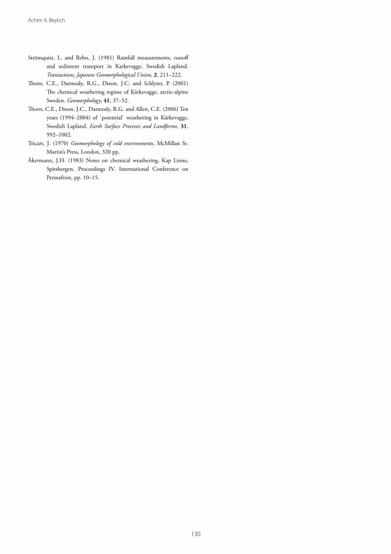
��0
Achim A. Beylich
Strömquist, L. and Rehn, J. (1981) Rainfall measurements, runoff and sediment transport in Karkevagge, Swedish Lapland. Transactions, Japanese Geomorphological Union, 2, 211–222.
Thorn, C.E., Darmody, R.G., Dixon, J.C. and Schlyter, P. (2001) The chemical weathering regime of Kärkevagge, arctic-alpine Sweden. Geomorphology, 41, 37–52.
Thorn, C.E., Dixon, J.C., Darmody, R.G. and Allen, C.E. (2006) Ten years (1994–2004) of `potential` weathering in Kärkevagge, Swedish Lapland. Earth Surface Processes and Landforms, 31, 992–1002.
Tricart, J. (1970) Geomorphology of cold environments, McMillan St. Martin’s Press, London, 320 pp.
Åkermann, J.H. (1983) Notes on chemical weathering, Kap Linne, Spitsbergen. Proceedings IV. International Conference on Permafrost, pp. 10–15.