securing eroding delta coastlines
TRANSCRIPT

Building with Nature Indonesia Securing Eroding Delta Coastlines
Design and Engineering Plan
Towards a district level Masterplan
Result:
Report Version: Date:
R.1.5 Design & Engineering Plan V7.0 May, 2015

Design and Engineering Plan / Result 1.5 /Version 6.7

Design and Engineering Plan / Result 1.5 /Version 6.7
Document identification
Project name Building with Nature Indonesia ~ Securing Eroding Delta Coastlines
Result R.1.5. Design & Engineering Plan + R.1.6. Hardware Plan
Filename Ecoshape (2015) R1.5_R1.6 Design & Engineering plan incl. Hardware plan
Authors Femke Tonneijck (Wetlands International), Han Winterwerp (Deltares), Bregje
van Weesenbeeck (Deltares), Roel Bosma (WUR), Dolfi Debrot (Imares), Yus
Rusila Noor (Wetlands International), Tom Wilms (Witteveen+Bos)
Reviewer Jaap van Thiel de Vries (Ecoshape)
Released by Jaap van Thiel de Vries (Ecoshape)
Date 15/07/2015
Dissemination level
x PU Public
PP Restricted to official project partners (including RVO)
RE Restricted to a group specified by the project partners (including RVO)
CO Confidential, only for official project partners (including RVO)


Building with Nature Indonesia Securing eroding delta coastlines
EcoShape
5

Building with Nature Indonesia Securing eroding delta coastlines
EcoShape
6
Content Executive summary .................................................................................................................................................... 8
1 Introduction ........................................................................................................................................................ 11 1.1 Problem ..................................................................................................................................................... 11 1.2 Towards a solution .................................................................................................................................. 11 1.3 Demonstration project to trigger change .............................................................................................. 12 1.4 Aim of this document .............................................................................................................................. 12
2 System analysis .................................................................................................................................................. 13 2.1 Biophysical system analysis ................................................................................................................... 13
2.1.1 Current status ....................................................................................................................... 13 2.1.2 Building with Nature potential .......................................................................................... 17
2.1.2.1 Sediment availability and transport potential ....................................................................... 18 2.1.2.2 Mangrove recovery potential ............................................................................................ 19 2.2 Socio-economic system Analysis ........................................................................................................... 20
2.2.1 Current status ....................................................................................................................... 20 2.2.2 Building with nature potential ........................................................................................... 21
2.3 Zonation based on system analysis ....................................................................................................... 22
3 Vision, system requirements and approach .................................................................................................. 24 3.1 Vision statement ...................................................................................................................................... 24 3.2 System requirements ............................................................................................................................... 25 3.2.1 Coastal safety requirements ................................................................................................ 26 3.2.2 Socio-Economic Requirements ............................................................................................ 26 3.3 Approach .................................................................................................................................................. 27 3.3.1 Bio-Rights mechanism ....................................................................................... 27 3.3.2 Coastal Field Schools ......................................................................................... 28
4 Potential Building with Nature Measures Demak ....................................................................................... 29 4.1 Potential coastal safety measures .......................................................................................................... 30 4.1.1 Hard engineering .............................................................................................. 30 4.1.2 Natural System Restoration ................................................................................................. 32 4.1.2.1 Restoration of Sediment Balance ....................................................................................... 33 4.1.2.2 Restoration of Hydrology ................................................................................................. 34 4.1.2.3 Ecosystem Restoration .................................................................................................... 35 4.1.3 Non-structural measures .................................................................................... 36 4.2 Socio economic measures ....................................................................................................................... 37 4.2.1 Improved Aquaculture ...................................................................................... 38 4.2.1.1 Innovative Systems ........................................................................................................ 38 4.2.1.2 Improved water management ........................................................................................... 39 4.2.1.3 Mangrove Restoration .................................................................................................... 40 4.2.2 Other socio-economic measures .......................................................................... 41 4.2.2.1 Wild capture fisheries ..................................................................................................... 41 4.2.2.2 Brushwood, NTFP and other ............................................................................................ 41

Building with Nature Indonesia Securing eroding delta coastlines
EcoShape
7
5 Spatial Design .................................................................................................................................................... 43 5.1 Mission statement methodology ............................................................................................................ 43 5.2 Spatial designs per coastal zone ............................................................................................................ 43 5.3 Coast 0 From Surodadi up to the Wulan delta .................................................................................... 43 5.3.1 Current status ................................................................................................... 43 5.3.2 Proposed Mission .............................................................................................. 44 5.3.3 Proposed measures and spatial design 2015-2019 .................................................. 44 5.4 Coast I/II From Bedono to Surodadi ..................................................................................................... 45 5.4.1 Current status ................................................................................................... 45 5.4.2 Proposed Mission .............................................................................................. 46 5.4.3 Proposed measures ............................................................................................ 47 5.4.4 Spatial design 2015 - 2019 ................................................................................... 48 5.4.5 Proposed measures and spatial design 2015 ......................................................... 50 5.5 Coast III From Bedono to Semarang ..................................................................................................... 51 5.5.1 Current status ................................................................................................... 51 5.5.2 Proposed Mission .............................................................................................. 51 5.5.3 Proposed measures ............................................................................................................... 52
6 Planning ............................................................................................................................................................... 53 6.1 Prioritisation and adaptive management cycle ................................................................................... 53 6.2 Annual Project Targets ............................................................................................................................ 54
Annex 1: Aquatic species already cultured in Demak district ......................................................................... 57
Annex 2: Aquatic species that will be new in Demak district ......................................................................... 58
Annex 3 Bio-Rights Approach ............................................................................................................................... 59 Introduction ......................................................................................................................................................... 59 Steps in Bio-rights approach .............................................................................................................................. 60
Step 1. Project Initiation ................................................................................................................... 60 Step 2. Project Development. .......................................................................................................... 61
Address policy hurdles ...................................................................................................... 62 Step 3. Administrative – Contract Matters .................................................................................... 62
Contract negotiation ........................................................................................................... 62 Contract signing .................................................................................................................. 63
Step 4. Project implementation ....................................................................................................... 64 Capacity building and awareness raising. ..................................................................... 64 Financial support disbursement. ..................................................................................... 64 Implementation of restoration and income generating activities. ............................. 65
Step 5. Project Monitoring and Evaluation.................................................................................... 65

Building with Nature Indonesia Securing eroding delta coastlines
EcoShape
8
Executive summary
This design and engineering plan is produced during the inception phase (result 1) of the project and should be understood as a preparation for result 2 in which we aim to implement a large scale demonstration project in Demak. As such, this plan provides the concepts, reasoning, design and practicalities for the timely implementation of Building with Nature measures in Demak district. It sets priorities and sequence of implementation, and addresses limitations and risks, which will be accounted for and resolved in an adaptive approach. Next to these practical aspects this report also aims to serve as input for fruitful stakeholder engagement at the community, district, provincial and national level (result 3 and result 5) and for the Environmental Impact Assessment (result 1.11). As demonstrated in the system analysis (Chapter 2), a lack of coastal safety is currently severely hampering socio-economic activity in Demak´s coastal zone. Conventional hard-infrastructure solutions to enhance coastal safety have been found to be ineffective, expensive and unable to adapt to climate change in soft muddy coasts. Furthermore, they fail to bring back the economic, environmental and social benefits that healthy mangrove coastlines could offer. A more holistic and long term solution like Building with Nature is needed that addresses both the root causes of the problem, while taking into account the economic and social well-being of the inhabitants. In line with this reasoning, we envision:
A safe and prosperous Demak district, in which a mangrove greenbelt provides the coastal safety and resilience needed for the communities to thrive such that in turn they can sustain the mangrove greenbelt they rely on.
As a project, we will help to realize this Master Plan vision by implementing measures that are specifically designed to trigger change at a larger scale by other actors. In line with the vision statement for Demak´s coastal zone as presented above, the (narrower) local project objective reads:
A large-scale implementation of the Building with Nature approach halts coastal erosion along a 20 km shoreline and triggers revitalization of 6000 ha of degraded aquaculture ponds in Demak district.
The vision statement implies that coastal safety measures need to be intricately linked to socio-economic measures. That is why we choose to implement such measures by introducing the Bio-Rights approach. Further, we explained that the Building with Nature approach is inherently an adaptive approach. First because it is a participative approach that needs various rounds of consultation especially with local communities. Secondly, because we need to `learn by doing´ and enhance our system understanding along the way. This is why we choose to facilitate the implementation of measures in Demak with Coastal Field Schools. Building with Nature solutions come in many different forms and shapes. Chapter 4 presents a range of potential coastal safety measures and socio-economic measures that may be applicable in Demak’s coastal zone and elsewhere in Northern Java. In Chapter 5 we present the spatial project design in which we elaborate which combination of measures we propose in the three coastal zones of Demak to achieve our vision. To determine the right combination of measures, the overall Demak vision is translated into a more specific mission statement for each of the coastal zones identified in Chapter 2. This mission statement takes into account the specific biophysical and socio-economic opportunities and constraints present.

Building with Nature Indonesia Securing eroding delta coastlines
EcoShape
9
Coast 0 From Tambakbulusan to Wulan Delta Given that currently there is no greenbelt and (unproductive or abandoned) aquaculture ponds are present up to the seafront, it is our proposed mission to:
Hold the line, by in the longer term converting aquaculture ponds at the seafront into a mangrove greenbelt for coastal safety as compensated for by revitalizing aquaculture in the hinterland in the short term.
This project will contribute in the following way towards achieving the mission for coast 0: Greenbelt zone Aquaculture zone Sub-result 2.4: no coastal safety target defined in coast 0, potential to leverage mangrove rehabilitation through Bio-Rights approach will be explored. Measures: - Feasibility Assessment
Sub-result 2.5: ~150 ha revitalised aquaculture; of which ~25 ha mixed mangrove-aquaculture system Measures: - Improved water management (150 ha) - Introduction of innovative multi-trophic aquaculture systems (~150 ha) - Introduction of mixed mangrove-aquaculture system (~25 ha) - Assisted natural mangrove regeneration/ enrichment planting in mixed mangrove aquaculture system (~ 15 ha)
Coast I/II From Bedono to Surodadi Given that a greenbelt is lacking and that erosion has taken hundreds of meters of aquaculture ponds, our proposed mission is to:
Advance the line, by restoring the conditions for a mangrove greenbelt and then revitalizing aquaculture in the hinterland to avoid return to aquaculture in the greenbelt zone.
Summarising, this project will contribute in the following way towards achieving the mission for coast I/II: Greenbelt zone Aquaculture zone Sub-result 2.4: 90 ha mangrove Measures: - Permeable dams to restore sediment balance, spatial arrangement of dams stimulates creek rehabilitation - Mud nourishment to restore sediment balance - Sand nourishment to restore chenier - Assisted natural regeneration - Enrichment planting
Sub-result 2.5: ~150 ha revitalised aquaculture; of which ~25 ha mixed mangrove-aquaculture system Measures: - Improved water management (150 ha) - Introduction of innovative multi-trophic aquaculture systems (~150 ha) - Introduction of mixed mangrove-aquaculture system (~25 ha) - Assisted natural mangrove regeneration/ enrichment planting in mixed mangrove aquaculture system (~ 15 ha)
Building with Nature Indonesia Securing eroding delta coastlines
EcoShape
10
Coast III Bedono to Semarang In view of the severity of erosion and subsidence and the peri-urban nature of Coast III, our proposed mission is:
Managed realignment, by starting a multi-stakeholder dialogue about re-alignment of the coastline to a more landward position and about suitable Building with Nature approaches to enhance coastal safety.
For coast III the aim is to initiate a multi-stakeholder dialogue that will focus on possible strategies for this coastal stretch. Development of a spatial design for coast III is outside the scope of the current project. Chapter 6 presents a yearly adaptive planning cycle, including yearly updates of the design and engineering plan and associated hardware plan (result 1.6) as based on monitoring and evaluation as well as consultation with stakeholders. This planning allows for alignment with government processes. Further, annual project targets are presented in a Table.

Building with Nature Indonesia Securing eroding delta coastlines
EcoShape
11
1 Introduction
1.1 PROBLEM
Northern Java’s deltaic shorelines suffer from severe erosion and related flooding hazards, caused by mangrove conversion for aquaculture, groundwater extraction and infrastructure development. At some places, the coast has retreated by hundred’s meters up to a few kilometres. As a result, over 30 million people in Java are at risk. The agriculture and aquaculture sectors, two engines of the regional economy, have suffered multi-billion losses. Conventional hard-infrastructure solutions have found to be ineffective, too expensive and unable to adapt to climate change. Furthermore, they fail to bring back the economic, environmental and social benefits that healthy mangrove coastlines would offer. With the loss of the mangroves, also the mangrove eco-system services have been lost, which has further affected the livelihood of the people living in the coastal plains and eliminated the natural environmental resilience so characteristic of mangrove systems. We refer to the project proposal for a more in depth description of the problem and its root causes.
1.2 TOWARDS A SOLUTION
Actors in Demak and elsewhere in Northern Java acknowledge that a fundamental shift in approach towards coastal vulnerability problems is required to restore and secure sustainable and climate-resilient economic development. A more holistic and long term solution is needed that addresses both the root causes of the problem, while taking into account the economic and social well-being of the inhabitants. Building with Nature can provide such a solution. Building with Nature is an integrated coastal zone management approach that provides resilience by combining smart engineering and ecological rehabilitation, while introducing a sustainable land use practice. It offers an alternative to conventional hard-infrastructure approaches to coastal security. Instead of fighting nature with dams and dikes only, Building with Nature solutions work with and along the dynamics of nature. For example, by allowing river flows and sea currents to reinforce the coastline with sediment. Or by restoring ecosystems so that they once more provide protection against extreme events and offer valuable ‘natural capital’ in the form of shell-fish, timber and recreational opportunities. Building with Nature solutions are climate-adaptive, and typically cheaper to construct and maintain, compared to static infrastructure solutions. The environmental co-benefits enable more productive and multi-functional land-use. Local stakeholders – including disadvantaged communities – are involved in design, construction and maintenance of measures. This renders the approach financially, institutionally, environmentally, technically as well as socially highly sustainable.

Building with Nature Indonesia Securing eroding delta coastlines
EcoShape
12
1.3 DEMONSTRATION PROJECT TO TRIGGER CHANGE
To demonstrate that this novel Building with Nature approach can indeed work in Indonesia’s coastal areas, we will implement a large scale flagship project in the severely eroding setting of Demak district, Central Java (result 2 of the project proposal and the focus of this report). In Demak, we will re-establish coastal security and support sustainable revitalization of 6000 ha of aquaculture ponds along a 20 km shoreline. This enhances safety, inclusive economic growth and self-reliance of 70.000 vulnerable people. Building with Nature measures in Demak will be embedded in community development plans, in a district level master plan and in provincial development plans (result 3, outside the scope of this report) and supported by intensive capacity building and knowledge transfer (result 4, outside the scope of this report). Moreover, this flagship in Demak will be used to bring the Building with Nature approach into mainstream coastal zone management across Northern Java. This will be done through outreach and national level policy dialogue with the aim to stimulate uptake of Building with Nature solutions in policies and planning and to enhance investment in Building with Nature by private sector and government (result 5, outside the scope of this report). This way, we hope that the flagship will trigger change beyond the project lifetime. This could indirectly result in increased resilience of 30 million people in Java who are currently at risk from coastal hazards, in both urban and rural areas.
1.4 AIM OF THIS DOCUMENT
This design and engineering plan is produced during the inception phase (result 1) of the project and should be understood as a preparation for result 2 in which we aim to implement a large scale demonstration project in Demak. As such, this plan provides the concepts, reasoning, design and practicalities for the timely implementation of Building with Nature measures in Demak district. It sets priorities and sequence of implementation, and addresses limitations and risks, which will be accounted for and resolved in an adaptive approach. This report does not present a final design. Instead we choose an adaptive approach for design and implementation for two reasons. First, the Indonesian stakeholders play a major and decisive role and need to be able to provide detailed feedback throughout the project. Indeed, this document already incorporates preliminary feedback from a wide range of stakeholders as obtained during a series of kick off workshops in March 2015 and follow up meetings. Second, accepting the fact that data availability on the system is still scarce, we have adopted a pragmatic ‘learning by doing’ approach to optimize the approach along the way. Because of the adaptive and participative nature of this project, this design and engineering plan needs to be regarded as a proposal for further discussions with stakeholders. While this proposed design is necessarily already relatively detailed for the first year ahead (2015), we plan to further elaborate and adjust the design for ensuing years over the course of this project as part of Result 2 (sub-result 2.1). Next to these practical aspects this report also aims to serve as input for fruitful stakeholder engagement at the community, district, provincial and national level (result 3 and result 5) and for the Environmental Impact Assessment (result 1.11).

Building with Nature Indonesia Securing eroding delta coastlines
EcoShape
13
2 System analysis
The first two sections of this chapter summarize the biophysical and socio-economic system analysis as presented in the Baseline report (Result 1.9), in support of the formulation of a vision for Demak’s coastal zone (Chapter 3) and to determine the measures that are possible and required to achieve this vision (Chapter 4 and 5). We start these sections with a description of the current status of the system, where possible including a discussion of the historic developments. Next, we discuss the ‘Building with Nature potential’, i.e. the available (natural or social) resources and processes we can use smartly when restoring the coastline as well as their limitations. Based on this, we present a zonation of the project area in section 3, to facilitate the implementation of specific combinations of coastal safety and socio-economic revitalisation measures. It should be noted that the system analysis is not complete because of a lack of data and at this stage part of the analysis is based on expert judgment. We aim to enhance our system understanding over the course of the project by further data collection and adopting a “learning by doing” approach which is supported by monitoring and evaluation (protocol to be developed as part of Result 2, subresult 2.6.1).
2.1 BIOPHYSICAL SYSTEM ANALYSIS
2.1.1 CURRENT STATUS
The Demak coastal zone is very shallow, with slopes of about 1:600, although the original slope is expected to have been much gentler (1:1000 or even 1:1500). The seabed and sub-bottom are extremely muddy, though the exact stratigraphy remains unknown. Large parts of the Demak coastal zone currently suffer from severe erosion at an average rate of 100 m/year, as depicted in

Building with Nature Indonesia Securing eroding delta coastlines
EcoShape
14
Figure 2.1. The road between Bogorame and Timbul Sloko is serving as the primary line of defence and is about to collapse, which would expose kilometres of hinterland to flooding.

Building with Nature Indonesia Securing eroding delta coastlines
EcoShape
15
Figure 2.1 Example of coastal erosion in Demak district near Timbul Sloko village, illustrated through the coastline in 2003 (blue) and in 2012 (red).
Coastal erosion can be caused by (a combination of) multiple factors. Establishing aquaculture ponds too close to the waterline, in conjunction with removal of the protecting mangroves has reduced the resilience of the coast by initiating a self-accelerating erosion process 1. This is then aggravated by establishing traditional hard structures for coastal protection. Until mid-way the 20th century Demak’s economy was based mostly on agriculture: dry land crops, coconut and rice. In the 1960s, part of Demak district’s landscape, with a focus on the basins near Semarang, was rearranged to optimise rice cropping. Canals for irrigation and drainage were built, and some creeks may have been straightened, but the coastal mangrove belt was still left intact. Between 1970 and 1980, the rural population was very wealthy as harvest of rice, shrimp and milkfish were abundant. In the 1980s, the demand for shrimp increased and the green revolution had resulted in decreased world market prices for rice. Together with the ban on fish trawling in 1984 this pushed the transformation of both paddy field and mangrove forests into shrimp ponds. In the 1990s, frequent losses of shrimp harvests due to diseases pushed farmers to open new ponds in the mangrove. As a consequence, at present the Demak study area is virtually devoid of the once extensive mangrove forests which were found here in the distant past. The Demak coastal zone is characterized by strong ocean-to-land environmental gradients (such as salinity gradients and flooding exposure). This is indeed witnessed in terms of changes in both natural and planted vegetation along the small road from the main coastal highway 4.5 km land inward to Timbulsloko at the seafront. On the landward side of this small road, the vegetation is dominated by grasses on the bunds and occasional Leucaena leucocephala, Turi (Sesbania grandiflora) and occasional banana plants. These gradually phase out to give way to a zone dominated by halophilic herbs such as Euphorbia curassavicus, and Sesuvium portulacastrum. Towards the seaward section, the vegetation is dominated by halophilic sedges (Cyperaceae) and pioneer mangroves and their associates. Five species of mangroves were identified, but the pioneer mangrove Avicennia marina and Rhizophora mucronata are strongly dominant. Sea level rise and subsidence further increase coastal vulnerability in the area. In and around Semarang large volumes of ground water are withdrawn from deep aquifers to satisfy the needs of the industry sector. But also rural villages have their own deep wells for household use and for aquaculture. The overlay of coastal erosion on the subsidence map of the Semarang area, as presented in Figure 2.2

Building with Nature Indonesia Securing eroding delta coastlines
EcoShape
16
demonstrates the contribution of subsidence to coastal retreat. Due to subsidence, salinity penetrates much further land-inwards than in former times. Indeed, saltwater intrusion into ground water and soil is reported to be a major problem in and around the Semarang area 2.
Figure 2.2 Overview of subsidence in and around Semarang, with an overlay of coastal erosion in the form of the coastline retreat since 1972 – the redder the colours, the larger the subsidence.
The above factors have made the Demak coastal system even more vulnerable to episodic events, such as the 2009 El Niño storms. For example, the one km of observed coastal retreat south of Bedono occurred largely in a brief period of time during those storms. We expect that the coastal system becomes more vulnerable to the effects of (accelerated) sea level rise as well. Coastal managers often try to fight coastal erosion and flooding with conventional hard solutions, such as dikes and seawalls, fighting the symptoms rather than address the root causes of these problems. This traditional response is also witnessed in Demak. However the construction of hard structures only aggravates the situation as this approach is unsuitable for soft muddy coastlines in rural areas. Hard structures may deteriorate the stability of the coast by blocking sediment transport towards the coast and may induce local scour by enhanced wave effects as a result of wave reflection 1. Also, the jetties protecting the port of Semarang penetrate some 3 km into the sea and are affecting eastward oriented residual fine sediment transports.

Building with Nature Indonesia Securing eroding delta coastlines
EcoShape
17
2.1.2 BUILDING WITH NATURE POTENTIAL
The Building with Nature approach for Demak province is based on the presumption that coastal safety is restored if the mangrove greenbelt is restored. Mangrove greenbelt systems along muddy coasts are dynamic systems, with sediment naturally eroding and accreting as a result of wave and tidal action. When a mangrove green belt is wide and self-maintaining, periods of erosion can be compensated for and the coastline restores naturally. Ample research has shown that mangroves are able to reduce wave heights over relatively short distances. Reductions of wave heights of 13-66% can occur within the first 100 m while reductions of 50-99% occur within 500 meters of mangrove forest 3. Most wave reduction takes place at the seaward edge of the mangrove zone and all exposed mangrove structures, from roots and stems to pneumatophores and even leaves, can contribute depending on the height of the wave’s passage through the forest. Although wind and swell waves are rapidly reduced as they pass through mangroves, wider mangrove belts of ideally thousands of meters across are needed to reduce the flooding impacts of storm surges occurring during major storms (also called cyclones, typhoons or hurricanes). See Figure 2.3.
Figure 2.3 Wind and swell waves are reduced within the first hundreds of meters of mangrove, while storm surges require greenbelts of ideally thousands of meters wide to reduce flooding impacts.
Mangroves also protect against wave impacts and flooding indirectly by helping to accrete land and hence increase shore elevation and slope 3. They can increase bed elevation levels by between 1-10 mm per year, depending on the location and conditions, and are able to moderate or even fully negate the effects of sea level rise over long periods 4. Bed surface elevation change is governed by a set of at least six processes opposing accretion and erosion (Figure 2.4), and results from the accretion of both endogenic (e.g., leaf litter, calcification by flora and fauna) and exogenic material (entrapped sediment imports). Mangroves also contribute to sediment consolidation/compaction which leads to firmer 4. So it is not only the dampening effects that mangroves have on waves, but also their influence on land accretion and compaction that contributes to coastal safety in the future.

Building with Nature Indonesia Securing eroding delta coastlines
EcoShape
18
Figure 2.4 Mangroves build and bind soils, thus counteracting erosion
A first necessary step to restore a mangrove greenbelt along the coastline of Demak is to stop the ongoing erosion and instead regain a stable coastline by restoring the sediment balance. This requires that the landward transport of fine sediment over the muddy foreshore exceeds the amount of fine sediment being washed away at the shoreline. In the next sections, we explore the availability of fine sediment and discuss the processes that transport them and the potential for mangrove recovery.
2.1.2.1 SEDIMENT AVAILABILITY AND TRANSPORT POTENTIAL
The tide near the Demak coastline is mixed with a pronounced diurnal signal, and small semi-diurnal components, which are of the same order as the secondary diurnal components. As a result, there is a pronounced variation in tidal water levels over time, though the periodicity of extreme water levels is highly irregular (see result 1.9 baseline). As a result, the tide does not depict the well-known 14-day spring-neap cycle characteristic elsewhere in the world. Neap-tidal range is about 40 cm, whereas spring-tide tidal range is about 100 cm. Currents in the Demak coastal waters vary, with maximal velocities of around 15 cm/s, however the location of this measurement is not known. Tidal currents close to the coast are more or less perpendicular to the coast, owing to the shallowness of the foreshore. Residual currents close to the coast are likely the result of large-scale wind-driven circulations varying with the monsoon, though in general these currents appear to be directed from NE to SW. However, these currents are small. On a larger scale, the residual ocean currents along the north coast of Java shift with the monsoon. During the SE monsoon (May-September) residual currents are towards the West, whereas during the NW monsoon and the transitional months (October-April), residual currents are towards the East. Wave heights up to 1.8 m have been measured offshore (~4 km), with a maximum significant wave height of 1.5 and a period of ~5.5 s. The mean wave height over 14 years of measurements is 0.46 m. The dominant wave direction is North and WNW. In 2009, much larger maximum wave heights were

Building with Nature Indonesia Securing eroding delta coastlines
EcoShape
19
recorded, with a significant wave height of 2.2 m and a period of over 8 s, likely related to El Niño. Close to the coast, the waves are directed more or less perpendicular to the coast because of refraction over the very shallow foreshore. The climate and hydro-sedimentological behaviour of the Demak coastal zone is strongly governed by the monsoons. The majority of rainfall occurs in the months December through February within the NW-monsoon (November – April). During the months December – February, higher waves are also found in the coastal zone. During the NW-monsoon riverine fresh water plumes are pushed against the coastline, diverting to the East, following wind direction and residual currents. The fresh water distribution induces a gravitational circulation along the coast, which keeps fine sediments close to shore. On the other hand, during the SE-monsoon (dry season), fresh water is blown into the ocean (Java Sea) and the effects of gravitational circulation are much more localized and there is no large scale transport of sediments near the coast. This is the period that fine sediments in Demak foreshore are lost in deeper water. Most of the erosion occurs during NW monsoon when winds are stronger and waves are higher. On the other hand, fine sediments carried by the rivers, and fines from the foreshore are also expected to be mobilized in this season, enlarging the suspended sediment concentration in the coastal zone that is available for the regeneration of the coast. The original source of fine sediments in the foreshore is terrestrial, as weathered sediments are carried by numerous small rivers to the coastal zone. In Demak, this supply has been active for centuries, maybe longer, and has even increased over the last decades owing to changes in land-use in the hinterland (terrestrial erosion). Those sediments used to be captured by the mangroves originally present in the coastal zone of Demak. However, with the loss of these mangroves, parts of those historic deposits have been lost in deeper water. A very rough estimate suggests that about half of those historic deposits have currently been lost, implying that it shall not be possible to restore the eroding Demak coast entirely to its 2003 position. As the loss of these sediments from the Demak coastal zone continues, measures for restoring the fine sediment balance in the coastal zone cannot be postponed.
2.1.2.2 MANGROVE RECOVERY POTENTIAL
Of the six principal physiographic mangrove community types described by Lugo and Snedaker 5, the main type which was formerly found along the north coast of Java is the “fringe mangrove community” 6. Fringe mangroves reach their highest extent of development in areas where the coastal alluvial plain is just above the mean high tide mark. This is the case in the Demak area where basically the whole aquaculture area (6000 ha) up to and out to the present sand cheniers once formed an extensive mangrove system of several kilometres width. Fringe mangrove communities show a characteristic zonation in species perpendicular to the coast 6. Landwards and upstream of the strict “mangrove association”, typically will once have had a Nypa association 6. Mangrove recovery is mainly constrained by physical conditions. Erosion has lowered bed surface elevation, degradation of cheniers has increased wave exposure and aquaculture ponds limit hydrological connectivity. Other major threats to the sea and coastal ecosystems in the area stem from rural, domestic and land-based pollution as well as from intense resource extraction. However, while pollution influx from land can be expected to partially limit fauna related recovery of ecosystem services (particularly crustaceans and the fish nursery function); it should not seriously impede mangrove growth or restoration itself. Mangroves are quite resistant to most forms of environmental pollution.

Building with Nature Indonesia Securing eroding delta coastlines
EcoShape
20
Our baseline study indicates that both planting mangroves (Figure 2.5) and natural recruitment can be successful as long as these physical constraints are dealt with. For two important species, namely Avicennia marina and Rizophora mucronata propagules and seedlings are already amply available in the area. But mangroves are highly zoned, and a more diverse mangrove community is required to trap sediment and build land throughout the coastal alluvial plains area. Mangrove growth and regeneration is rapid in the area. Naturally recruited A. marina grow to the size of small 4-m-high adult trees within 5 years, while the same is the case for planted R. mucronata (Fig. 2.1). Today mangroves were seen growing successfully all along the whole 4 km of the alluvial plain area from the junction of the main road between Demak and Semarang all the way out to Timbul Sloko.
Figure 2.5. Mangroves of respectively 6 months (a), 1 yr. (b) and 5 yrs. after planting in Timbulsloko (Arief in picture).
Where aquaculture ponds are still present (i.e. at the seafront as well as land inward along rivers), a lack of hydrological connectivity and available space is limiting mangrove recovery. Where aquaculture ponds have eroded, wave exposure and surface elevation are limiting mangrove recovery. These physical constraints need to be addressed from mangroves to re-establish.
2.2 SOCIO-ECONOMIC SYSTEM ANALYSIS
2.2.1 CURRENT STATUS
The present generation of inhabitants in the coastal communes of Demak district has specialised in aquaculture and some inhabitants still practice traditional fisheries. The baseline study (result 1.9) identified that the main livelihood occupations of the households in the villages of the project area were fish farmer or fisherman (70%). Other important income sources were: farm labourer (25%), temporary and industry labourer (10%), trader (8%), and government staff (2%). Yet, a lack of coastal safety (flooding, erosion) and a lack of proper water management are currently severely hampering socio-economic productivity. The baseline study (Result 1.9) identified that the average income from aquaculture and fishing was 17.5 and 1.2 million IDR/yr./household. On average, the household income from other sources was higher (3.3 million IDR/yr.) than from fisheries. Further, the baseline study identified that at present yields of shrimp and milkfish farming are 43 and 192 kg/ha/year, respectively. In the past, the Demak area supported larger village populations based mainly on rice cultivation, together with healthy and productive mangrove fisheries. However in the foregoing decades, habitat destruction, loss of freshwater influx and obstruction of connectivity mean that rice culture is no longer possible and even aquaculture (limited by erosion, salinity and water circulation) and fisheries have become marginal. In the communes near Semarang, seawater intrusion started shortly after 1990, and gradually rice culture had to be abandoned. Traditionally shrimp culture in Java was mixed with milkfish. After the irrigation

Building with Nature Indonesia Securing eroding delta coastlines
EcoShape
21
canals near Semarang got polluted with industrial and urban waste water, farmers with no access to clean brackish water turned to tilapia and as a last resort back to milkfish only. At present many ponds are farmed extensively, are unused, or used for other purposes. Moreover draining of the ponds has become impaired because of land subsidence. This subsidence is caused by groundwater extraction for industry and people, and is not compensated for by sedimentation as the mangroves that capture sediment have disappeared. Further, sea level rise is projected to cause flooding 6 km inland by 2100, inundating 14,700 ha 7, of which 6000 ha aquaculture within the project area. Aquaculture is a private business and farmers and investors started this business to make as much money as possible with as little investment as possible. In the former mangrove forest, this happened without considering neither the environment nor an optimal landscape level design for water management. Further in-land, in the (former) rice fields, a proper water provision and drainage scheme were put in place in the sixties and seventies of the last century. However, during the expansion of aquaculture state intervention was absent. This means that currently the water management system is far from optimal.
2.2.2 BUILDING WITH NATURE POTENTIAL
Most of the rural land in Demak district is owned by small scale farmers and fishermen originating from the coastal villages. These populations have either lost everything or are on the edge of losing all their natural resources. Several pilot studies in Indonesia have demonstrated that these populations are willing to participate in the recovery of livelihoods from fisheries and mangrove, in particular if their income from aquaculture improves. However, locally, investors acquired larger plots to build intensive shrimp farms and they may be reluctant to participate in land reforms because they won’t benefit as much from the improvements as the small scale farmers who didn’t yet intensify their aquaculture. The communes of Demak nearest to Semarang that have lost their land or suffer from severe flooding and salt intrusion have become peri-urban living quarters for the younger generation who work in the nearby industrial zone and in the city. Farming and fishing contribute little to the income of most households in these communes and it may be a challenge to involve these inhabitants in the revitalisation of aquaculture. Engaging the local communities through the Coastal Field School and the Bio-Rights approach will allow to double shrimp yield (43 to 95 kg/ha) and the annual profit per hectare can increase from close to 20 million IRP to more than 55 million IRP within some years 8. Income will increase further from the recovered catches from fisheries, non-timber forest products from mangrove, and from further intensification in aquaculture (once the basic sustainability is recovered). Restoration of a mangrove greenbelt for coastal safety would also be of value for aquaculture by filtering pollution from water. Mangroves can trap, transform, and export nutrients from various natural and human sources 9,10. Without mangroves to filter the water, pond waste water from aquaculture often has to be reused causing self-pollution 11 Mangrove ecosystems deal with excess nutrients and pollutants in three ways: 1) absorbing pollutants and storing them in roots, stems and leaves (nutrients such as N and P, and heavy metals), 2) improving sedimentation of suspended materials (heavy metals, P, suspended solids), and 3) providing a habitat for waste decomposing (micro-) organisms 12. Mangroves are among the most valuable ecosystems in the world. Alongside protecting coasts from wave damage and erosion and building up sediments, mangroves are breeding grounds for fish, and rich sources of timber, fuel wood and non-timber forest products. In some places mangroves generate revenues from tourism and recreation. Further, mangroves can enhance recovery after coastal disasters, by providing food, fuel wood and construction materials.

Building with Nature Indonesia Securing eroding delta coastlines
EcoShape
22
2.3 ZONATION BASED ON SYSTEM ANALYSIS
The system analysis presented here enabled the division of the Demak coastal zone into four different zones on the basis of severity of erosion and subsidence as well as aquaculture practice (Figure 2.6). These zones are used to determine the design and engineering methods required for landscape restoration and are also used to delineate the socio-economic measures required. Coast I and II are discussed together, since differences between them are relatively minor from the point of view of the design of measures. Figure 2.6. Zonation of project area on the basis of severity of erosion and subsidence as well as aquaculture practice.
In Coast 0, the northern part of Demak´s coastal stretch, from Tambakbulusan up to the Wulan river delta, the coastline has been stable since 2003 and relatively little erosion has been observed. Cheniers are still in place and help attenuate waves. However, mangroves have largely been converted into aquaculture in this area and the area may be affected by subsidence as well. Aquaculture ponds are present up to the seafront. Most farmers practice extensive aquaculture (milkfish, shrimp) in intact ponds with or without mangrove on the dikes, in destroyed netted ponds or in seasonal systems: aquaculture in the wet season and salt or rice in the dry season. Over 100 ha of ponds are abandoned, either because of abrasion, because the renters/owners found another livelihood, or because the available water was too dirty. Less than 10% of the land is rice field (about 200 ha). In Coast I-II, from Surodadi up to Bedono, erosion is worse going from North to South. Cheniers are still in place, but likely degraded. Near Surodadi, coastal erosion is clearly starting but it is still relatively limited, while the Timbul Sloko area is already severely affected by erosion and subsidence, and the coastline has retreated by many hundred’s meters, up to one kilometre. In quiet water zones in the eroded areas, mangroves have re-established, and/or replanted mangroves develop well. A few measures have already been implemented in Coast I/II, such as the construction of an offshore breakwater and of a
Building with Nature Indonesia Securing eroding delta coastlines
EcoShape
23
protective seawall that surrounds the villages. Many aquaculture ponds located at the seafront have been lost. More land inward extensive aquaculture (milkfish) is still in place, but ponds are largely unproductive due to pollution, impaired drainage and flooding caused by subsidence and erosion. In Coast III, from Bedono to Semarang, erosion is severe and likely affected heavily by subsidence. Most farmers practice extensive aquaculture (milkfish, shrimp) in destroyed netted ponds, which are permanently flooded due to subsidence and erosion.

Building with Nature Indonesia Securing eroding delta coastlines
EcoShape
24
3 Vision, system requirements and approach
3.1 VISION STATEMENT
As demonstrated in the system analysis (Chapter 2), a lack of coastal safety is currently severely hampering socio-economic activity in Demak´s coastal zone. Conventional hard-infrastructure solutions to enhance coastal safety have been found to be ineffective, expensive and unable to adapt to climate change in soft muddy coasts. Furthermore, they fail to bring back the economic, environmental and social benefits that healthy mangrove coastlines could offer. A more holistic and long term solution like Building with Nature is needed that addresses both the root causes of the problem, while taking into account the economic and social well-being of the inhabitants (Figure 3.1). In line with this reasoning, we envision:
A safe and prosperous Demak district, in which a mangrove greenbelt provides the coastal safety and resilience needed for the communities to thrive such that in turn they can sustain the mangrove greenbelt they rely on.
Figure 3.1 Our vision for a sustainable coastal system
This long-term vision is shared among the Indonesian and Dutch project partners and is based on discussions with multiple local, provincial and national stakeholders since 2012. This vision may be applicable to other coastal areas in Northern Java as well.

Building with Nature Indonesia Securing eroding delta coastlines
EcoShape
25
Figure 3.2 illustrates the coastal landscape of Demak district according to this vision, with a ‘greenbelt zone’ at the seafront and an ‘aquaculture zone’ behind it with mangroves protruding land inward along rivers. In the course of the project, we will seek formal endorsement and further refinement of this vision by local stakeholders in the form of a Masterplan, as part of Result 3. A shared long-term, landscape level vision will help the multiple stakeholders – including the project partners – to align the implementation of coastal safety as well as socio-economic measures, and set priorities in these. This vision will be explained in more detail for each of the coastal zones in Chapter 5. Figure 3.2 Proposed landscape vision, as input to discussions on a Master Plan for Demak district.
As a project, we will help to realize this Master Plan vision by implementing measures that are specifically designed to trigger change at a larger scale by other actors. In line with the vision statement for Demak´s coastal zone as presented above, the (narrower) local project objective reads:
A large-scale implementation of the Building with Nature approach halts coastal erosion along a 20 km shoreline and triggers revitalization of 6000 ha of degraded aquaculture ponds in Demak district.
3.2 SYSTEM REQUIREMENTS
The desired level of ‘coastal safety’ and ‘socio-economic prosperity’ as described in the vision statement needs to be further specified and translated into requirements to the biophysical (mangrove) and socio-economic (aquaculture) systems so that appropriate measures can be designed.

Building with Nature Indonesia Securing eroding delta coastlines
EcoShape
26
3.2.1 COASTAL SAFETY REQUIREMENTS
In the context of Demak, coastal safety is defined in terms of halting erosion and reducing saltwater intrusion and coastal flooding. The main targets for coastal safety are to protect people and their houses from flooding and to keep vital infrastructure, such as roads and power supplies, safe. To achieve this, a mangrove belt is needed that is able to attenuate sufficient waves, trap sediments, and harbours enough diversity to be considered stable and resilient against disturbances (such as climate change).
The amount of wave reduction that can be achieved by the mangroves depends largely on the hydraulic conditions and on properties of the mangrove forest. Hydraulic conditions are mainly determined by incoming wave height, wave period and water depth. Vegetation properties consist of the height of the vegetation, the tree density, the stem diameter and the flexibility of stems 13,14 and notably also the greenbelt width. Although, in many coastal policies a mangrove greenbelt of 100 meters is mentioned, a wider greenbelt is desirable, both with respect to the capacity for wave reduction of the greenbelt 3 and with respect to its stability and resilience to disturbances 15. For conditions in Demak, where water levels will not often be higher than 1 meter above mean sea levels and waves are not higher than half a meter, a mangrove forest does not need to be extremely wide to reduce hydraulic impacts. However, if we take into account that the forest should trap sediment and be ecologically resilient we need more width. Some measurements show that for consistent sediment trapping widely spaced forests with old trees showed high variability in the first 100 metres 15, implying that a wider greenbelt is needed. In Indonesian decrees and documents the obligatory mangrove greenbelt width has been varying between 50 and 400 meters (Mangroves along river banks) and has been around 200 meters for coastal green belts 16. Based on a single study in 1986 greenbelt width is set at 130 times the annual tidal range 16. This translates for Demak into a green belt of between 100 and 130 meters wide. However, as we know little from greenbelt width and as what we know mostly deals only with the width required for a single service, we propose to strive towards a greenbelt between 500 metres and 1 km in the Demak area for safeguarding a sustainable coastal safety. This does not allow for use of the greenbelt for aquaculture pond construction. If part of the greenbelt is mixed mangrove and aquaculture, it needs to be even wider. The target greenbelt width needs to be agreed upon by multiple stakeholders and embedded in the Masterplan. Concluding, to achieve coastal safety we need a mangrove that fulfils the following requirements:
• A coastal mangrove green belt between 500 and 1000 meters wide, consisting of a mix of native species, with a diversity typical for this part of Java (the ‘greenbelt zone’).
• Connectivity of the coastal greenbelt with the hinterland through the presence of a mangrove belt of 50 m large along (tidal) creeks and rivers.
Additionally, to achieve the desired level of coastal safety, mangroves may (temporarily) need to be combined with other measures, for example to protect critical infrastructure and villages where there is a lack of space.
3.2.2 SOCIO-ECONOMIC REQUIREMENTS

Building with Nature Indonesia Securing eroding delta coastlines
EcoShape
27
In the context of Demak, we define ‘socio-economic prosperity’ as a level of welfare for the local communities that enables them to have a satisfactory livelihood as well as to sustain the mangrove greenbelt so that it continues to provide the safety that the local economy depends on. In other words, it is our goal to support the development of resilient and sustainable livelihoods in the destroyed or threatened coastal zone of Demak district, such that these livelihoods benefit from mangroves, and that the depending populations consider mangrove maintenance as a condition for the survival of themselves and future generations. To achieve a prosperous communities that are able to sustain the mangrove greenbelt the socio-economic system in the ´aquaculture zone´ behind the mangrove greenbelt needs to be restored to: • Enhance income with 25%, by enhancing average aquaculture productivity with 50% as a result of
enhanced and diversified management practices and • Upon recovery of the mangrove greenbelt, complement income from aquaculture with mangroves
goods and services. • Establish a clear link between the coastal safety measures and socio-economic measures, so that
stakeholders understand that these elements are interdependent. • Improve critical thinking skills, resulting in a more effective engagement in coastal protection and
aquaculture as well as greater self-reliance, resulting in better response to adversity.
3.3 APPROACH
The vision statement implies that coastal safety measures need to be intricately linked to socio-economic measures. That is why we choose to implement such measures by introducing the Bio-Rights approach. Further, we explained that the Building with Nature approach is inherently an adaptive approach. First because it is a participative approach that needs various rounds of consultation especially with local communities. Secondly, because we need to `learn by doing´ and enhance our system understanding along the way. This is why we choose to facilitate the implementation of measures in Demak with Coastal Field Schools.
3.3.1 BIORIGHTS MECHANISM
Bio-Rights is a financial incentive mechanism that reconciles economic productivity with environmental conservation and restoration. The Bio-Rights approach has been successfully piloted in Kalimantan, Java and Sumatra 17 and is also deemed suitable for Demak district. In return for active engagement in conservation and restoration measures, communities receive (financial) support to develop sustainable livelihoods that will generate income. In the case of Demak this translates into coastal safety measures on the one hand and sustainable aquaculture on the other hand. Bio-Rights agreements are conditional. This means that payments to communities will only be provided subject to successful restoration. The approach covers the costs communities face to change their current unsustainable practice (degrading the very mangrove greenbelt that they rely on for coastal safety) into long-term sustainable livelihood strategies. This motivates them to take a long-term interest in their conservation work as well. Legal contractual agreements need to be set up with community groups, rather than with individuals, and should be witnessed by the village government. This ensures a greater group cohesion and responsibility in implementing the agreement and also to motivate each other to accomplish both restoration and livelihood activities. This will also increase the project implementation efficiency, contribute to the project sustainability and reduce the overhead costs. For more information on the Bio-Rights approach, please see

Building with Nature Indonesia Securing eroding delta coastlines
EcoShape
28
Annex 3. The Bio-Rights approach relies on intense capacity building and awareness raising which in this case will be achieved through setting up Coastal Field Schools. Stanley18 listed four factors that limited the restoration of mangrove within areas used for extensive shrimp farming that are essentially addressed through the Bio-Rights approach. (1) The remuneration in so-called Pay-Plant-Go Models should be adequate compared to other livelihood alternatives; wages paid should not be less than the regular payments. The financial flow has to be made transparent to the community to demonstrate the integrity of the implementers and the managerial top of the stakeholders. Clearly, the Bio-Rights model is more sophisticated than the Pay-Plant-Go Model. (2) Returns from the ecosystem: strategies involving the community as labourers will backfire if the community will not be involved in forest management and not enjoy the benefits of the forest. The latter is the major social strategy for the long term success of any mangrove rehabilitation program. (3) Most of the community mangrove projects lack social tuning. The social meetings were targeted to mobilize labour and in most cases the long term future of the forests or their sustenance attached with ecosystems are hardly explained, and no strategy of “Social fencing” was agreed upon. Before starting it is suggested that strategy of addressing the pressures and providing alternative sources of fuel or fodder would better prevent degradation, destruction or overexploitation. (4) The reason for failure in genuine social participation is basically due to lack of immediate visible returns from mangroves. New livelihood activities need to be made available either directly or indirectly from the mangrove itself, or from e.g. improved aquaculture and fisheries.
3.3.2 COASTAL FIELD SCHOOLS
Coastal field schools are extensive year-long learning programmes that enable communities to advance their livelihoods by sustainably managing their coastlines and its natural resources. We follow Bennett’s project design hierarchy, rolling out an iterative training process, that offers training activities to community members and defining subsequent trainings on the basis of participant responses. The rationale is that such an interactive approach results in increased motivation and capacities to act and a measurable behaviour change that contributes to the project´s overall objective. Lead by local facilitators, the field schools empower marginal communities by increasing skill in both technical, political, market and social domains. Communities trained through the Coastal Field School approach are committed and able to: • Involve in the construction and maintenance of Building with Nature measures for coastal protection; • Implement sustainable livelihoods activities that benefit from restored coastal ecosystem services,
including those related to aquaculture and near-shore fisheries; • Adopt adaptive development approaches, on the basis of critical thinking and learning-by-doing
approaches • Organise themselves and be acknowledged as leaders in the development and implementation of
coastal zone management plans. The Coastal Field School approach is elaborated further in the Technical Assistance Plan (Result 1.4).

Building with Nature Indonesia Securing eroding delta coastlines
EcoShape
29
4 Potential Building with Nature Measures Demak
Clearly, various combinations of measures need to be taken to gradually transform the current degraded landscape into the envisioned landscape that fulfils the system requirements (e.g. Figure 4.1). Figure 4.1: Towards a sustainable coastal system
Building with Nature is an integral coastal zone management approach that restores coastal safety by combining smart engineering and ecological rehabilitation, while revitalizing the economy by introducing sustainable land use practices. Building with Nature solutions come in many different forms and shapes. In the following sections, a range of potential coastal safety measures (section 4.1) and socio-economic measures (section 4.2) are presented that may be applicable in Demak’s coastal zone and elsewhere in Northern Java. In Chapter 5 we present the spatial project design in which we elaborate which combination of measures we propose in the three coastal zones of Demak to achieve our vision.
Socio-economic measures
Coastal safety measures

Building with Nature Indonesia Securing eroding delta coastlines
EcoShape
30
4.1 POTENTIAL COASTAL SAFETY MEASURES
In this section, we present potential coastal safety measures in Demak along with their advantages and disadvantages. We distinguish hard engineering and natural system restoration measures as well as non-structural measures, see Figure 4.2. Combinations of measures are needed to achieve Disaster Risk Reduction. Figure 4.2: Overview of potential coastal safety measures applicable in Demak. Together all these measures contribute to Disaster Risk Reduction. Note that not all of these measures will necessarily be carried out within the project itself; rather they serve as input for discussion in the context of the district level Masterplan.
4.1.1 HARD ENGINEERING
Throughout the world, the establishment of hard structures has been the traditional response to coastal erosion and flooding. Indeed, also in Demak various hard structures have been put in place. However, in muddy environments like Demak, such hard structures disturb the balance of incoming and outgoing sediment which ultimately exacerbates the erosion problem 1 .This is because waves get bigger when they reflect on a hard structure. These bigger waves can erode 2 to 4 times more soil in front of the hard structure, eventually leading to the collapse of

Building with Nature Indonesia Securing eroding delta coastlines
EcoShape
31
the structure. At the same time, the tide cannot bring enough fine sediment in, as it is blocked by the (collapsed) hard structure. Eventually, erosion creates a tidal flat with steeper slopes, and deeper water at the seaward edge. As a result, waves can penetrate further, enhancing their erosive forces. Because of this, hard structures on muddy soils require sophisticated bed protection and/or soil improvement, which is expensive to construct and maintain. Lastly, hard structures disturb re-establishment of a healthy mangrove ecosystem by disturbing the sediment balance and hydrology. Even though mangroves may start to recolonize directly behind the hard structure at a local scale, such hard structures inhibit mangrove recovery at larger (green belt) scale. Examples of hard structures (Figure 4.2) are breakwaters, groynes, seawalls and sand bag barriers. Breakwaters are coast-parallel structures which aim at reducing wave heights at the coastline. As explained above, coast-parallel breakwaters also decimate the fine sediment flux towards the coast and therefore generally work contra-productive on soft soils 1. Groynes are hard structures perpendicular to the coast with the aim to reduce alongshore transport. As alongshore transport on shallow muddy foreshores is small, such structures have little to no effect. Seawalls are hard structures placed at the boundary of land and sea to protect the hinterland from waves and tides. When dense populations or economically valuable activities have developed too close to the waterline, such seawalls may be necessary. However, they offer only a temporary and local solution and in the long run only exacerbate erosion as explained above. Moreover, such structures require sophisticated bed protection and/or soil improvement. Earthen bunds and levees are basically low-tech seawalls aimed at safeguarding the hinterland from daily/frequent flooding. These structures are generally not very durable, but have the advantage that maintenance is easy and can be carried out by local communities. Sandbags can be used as bed protection for hard structures, by adsorbing wave forces and reducing piping (leakage through the underlying soil). Barriers made of sandbags may also be used as a temporal protection of mangrove stands from too energetic waves and/or to hold sediments for locally raising the seabed. But ultimately a sandbag barrier will act as a hard structure and will exacerbate erosion. Geotubes are long sandbags, containing sediments packed in filter cloth. Also geotubes can be deployed as temporal protection, but will not contribute to the restoration of the mangrove forest. Note that the use of bio-degradable materials may enhance the applicability of sandbags and geotubes. Hard structures can also play a role in regaining lost land. Polders are ring-dykes enclosing a particular piece of land or sea, which are drained mechanically e.g. by pumps. This way, the land inside a polder can stay productive and habitable. Though expensive, polders may be an option in areas where subsidence is too large for the natural system to re-establish within a reasonable timeframe, like in Demak Coast III. When properly designed, polders are generally safe and can protect the hinterland as well. When used as a stand-alone solution, hard structures clearly ‘fight nature’, and as such they are not a preferred option in the Building with Nature approach. However, sometimes hard structures are the only option, for example because there is limited space available, like in urban settings or around villages. In those cases, hard structures can often be combined with natural elements to attenuate waves, which reduce construction and maintenance costs while also offering other benefits like recreation.

Building with Nature Indonesia Securing eroding delta coastlines
EcoShape
32
4.1.2 NATURAL SYSTEM RESTORATION
The main solution we propose to achieve coastal safety in Demak is to bring back a healthy mangrove ecosystem. To do this, we need to restore the currently degraded system back to its original state in terms of ecological, physical and chemical system properties 19. Proper restoration pays attention to both ecosystem structures, such as diversity and species composition, as well as to ecosystem functioning (Figure 4.3). Strictly speaking, the term restoration is used when the original state of the system is recovered while rehabilitation is used when that is no longer possible. In that sense, we will practice rehabilitation in Demak rather than restoration.
Figure 4.3 Differences in restored and degraded ecosystems with respect to ecosystem function and structure (after Bradshaw 20)
There is ample experience with restoration of mangrove ecosystems worldwide. Rehabilitation efforts are typically successful in sheltered and accreting areas, while in eroding settings and former aquaculture areas restoration tends to fail. Brown and Lewis 21 developed useful guidelines for successful mangrove restoration that focus on identifying and addressing the factors that are limiting mangrove recovery. Summarized and slightly modified for our purpose these steps include:
1. Understanding the ecology of mangrove species at the site (where would they naturally occur and what are their limitations for growth)
2. Understanding the hydrological patterns (as these are of vital importance for the establishment of a healthy mangrove forest)
3. Assessing modifications of the original mangrove environment (as these are currently preventing natural recolonization of mangroves)
4. Designing the restoration measures to restore abiotic conditions that will allow for natural settlement of mangrove propagules
5. Planting of propagules, or of collected or cultivated seedlings should only be executed if natural recruitment does occur or does not provide the quantity of successfully established seedlings. Planting should only be done with the right species in the right place, meaning that species should be put under conditions where they would naturally occur and that natural recruitment and succession sequences should be honoured as much as possible.

Building with Nature Indonesia Securing eroding delta coastlines
EcoShape
33
Our system analysis (addressing steps 1 – 3) showed that mangrove recovery is mainly hampered by physical constraints, either a lack of surface elevation (coast I-II) and/or a lack of hydrological connectivity (coast 0). In the next sections we will present the proposed measures to restore the sediment balance and hydrological connectivity (step 4) and further ecosystem restoration measures (step 5).
4.1.2.1 RESTORATION OF SEDIMENT BALANCE
In areas that are suffering from severe erosion, a first step is to restore the sediment balance to stop the erosion process and regain a stable coastline. More sediment needs to be deposited on the coast than the amount being washed away and we will stimulate this through various measures. Permeable structures made of local materials such as bamboo, twigs or other brushwood are designed to function as sediment traps. These structures let the sea and river water pass through, attenuating the waves rather than reflecting them. As a result, waves lose height and energy before they reach the coastline. The permeable structures also let mud from the seaside pass through, while creating calm water conditions allowing net settling of fine sediments. This way the structures increase the amount of sediment trapped at or near the coast. These devices imitate nature – mimicking the structure of a natural mangrove root system (Figure 4.4.).
Figure 4.4. Permeable dams mimic the structure of mangrove root systems to trap sediment and dampen waves.
Permeable dams should always be placed in the back of the area to be restored, advancing step by step in seaward direction. If not, too little sediment may be mobilized, and worse, large deposits further offshore are likely to reduce sedimentation rates in the back, yielding the risks of water logging. Permeable dams are in particular effective during the stormy season (December – February), because the larger waves during the monsoon bring in more sediment to be trapped while the dams protect the hinterland from further wave attack. Once the erosion process has stopped and the shoreline has accreted to sufficient elevation, mangroves are expected to colonize naturally. The mangroves can then further break the waves and capture sediment and are intended to eventually take over the role of these dams. Hence, the permeable dams at least need to stay in place long enough for mangroves to take over, which is a sum of the sediment accretion rate (2 – 5 years) and rate of mangrove recovery (3 – 5 years). At the targeted front of the mangrove green belt, more permanent permeable structures are required, as these will form the primary sea-defence (means to dissipate wave energy) until also the muddy foreshore (mudflat) is restored.

Building with Nature Indonesia Securing eroding delta coastlines
EcoShape
34
Permeable dams can be combined with mud nourishment and agitation dredging to increase the amount of available sediment in the coastal fundament. Mud nourishment is the artificial placement of a mud patch at the edge of the foreshore to be carried by the tide to the coastline and to be trapped behind the permeable brushwood dams. This “mud motor” has the same function as the Sand Motor along the Dutch coast. By agitation dredging, sediments from the foreshore are brought into and mixed over the water column by mechanical means, again with the aim to enlarge the sediment flux towards the coast during rising tide. Within the SWF-project, mud nourishment is foreseen in Coast II. The Demak foreshore is too mildly sloped to enable agitation dredging (transport distance becomes too large). Many mangrove-mud coasts are characterized by a chenier at or close to their coastline. A chenier is a lens of sand, sitting on muddy subsoil. A chenier is formed, and migrates by classical cross-shore and alongshore transport by waves. In that sense, cheniers break/dissipate part of the incoming wave energy. Also the Demak coast has a chenier. In the northern part of the province, the chenier is still an integral part of the coastline. However, in Coast I, II and III, the chenier lies in the middle of the sea, as it remained in place, while the mangrove coast retreated. Our visual observations confirmed that the chenier in Coast II still exists and dissipates part of the waves. However, being fully exposed, depleted of further new supply of sand, subject to subsidence, and without a supporting mangrove forest at its back, this chenier is likely to disappear in time. We will monitor the development of this chenier in the coming years. If we feel that its function reduces too fast, we will consider sand nourishment of that chenier, provided that sand can be sourced sustainably. Note that this needs to be accompanied by mathematical modelling for determining the chenier dimensions. If nourishments are too large, the chenier may also kill the waves necessary for mobilizing the sediments to be carried to the coast by the rising tide. In fact, such a chenier would then be as detrimental as a coast-parallel breakwater.
4.1.2.2 RESTORATION OF HYDROLOGY
In many aquaculture areas, the hydrological connectivity is severely disturbed by bunds, channelization and degraded tidal creeks. This causes a lack of tidal fluctuation, salinity build-up, a lack of sediment supply and limited dispersal of propagules which all hampers mangrove recovery and functioning. In fact, restoration of hydrological connectivity is mentioned as one of the most (cost-) effective strategies for mangrove restoration and it is the crux of Ecological Mangrove Restoration 22–25. Hence, restoration of a mangrove greenbelt for coastal safety requires restoration of the hydrology. Several combinations of measures are needed to restore the hydrological system. Breaching of bunds at strategic locations is needed to allow input of freshwater, seawater and sediment. Lee et al. 26 provide in their mangrove manual full protocols for pond reversion and will be used to guide the process in the (former) pond areas. For instance, shallow ponds are less useful for aquaculture and easier to restore with mangroves. Breaching the pond bunds at a few strategic locations following a plan based on former creek positions is better than random breaching at many locations. Note that integrating such ponds in restoration requires also sedimentation in such ponds attaining the proper mangrove habitat conditions (bed height). Tidal creek restoration should reconnect the sea and the hinterland and as such once again become the main conduits for natural propagule dispersal inland. This requires removal of obstructions (including sediment) and reopening of drainage channels from the sea. Lastly, river restoration is needed to enable unobstructed freshwater and sediment inflow from areas landside of the project area. River re-alignment and/or branching can further enhance connectivity. Moreover, salinity levels may be reduced if the residence times of fresh water can be increased. Most of the roads are interrupted by the rivers and

Building with Nature Indonesia Securing eroding delta coastlines
EcoShape
35
drainage channels, which are crossed with bridges. Connectivity is therefore not affected by these roads. However, in cases where the exchange of water would be troubled, culverts underneath the roads are easily constructed. Aquaculture operations require careful regulation of salinity, depending on the type of fish or shrimp cultured. To regulate salinity, fresh water is often extracted from wells and this can cause subsidence. In the case of Demak, subsidence can be much more severe than projected sea level rise (see Chapter 2), hence it is imperative to stop or strictly regulate ground water extraction from shallow and deep wells. If not, subsidence will continue, and in conjunction with sea level rise, this will be difficult to neutralize with other measures. Our measures to revitalise aquaculture ponds will be designed such that they make optimal use of surface freshwater flows. Simultaneously, groundwater extraction for industrial use in nearby Semarang is also affecting the rural areas of Demak and this needs to be flagged, but is not part of our project scope.
4.1.2.3 ECOSYSTEM RESTORATION
Once the sediment balance and hydrology have been restored, mangroves can often regenerate naturally and this is our main approach to the restoration of the ecosystem rather than mangrove planting. Indeed, in Demak we have observed that mangroves colonize the foreshore whenever the habitat conditions are favourable. This natural colonization should not be disturbed by walking in the area or by other activities such as mangrove planting. It is important to realize that naturally recruited Avicennia will exhibit a far larger growth rate than planted species or seedlings. Hence, replacing natural seedlings for manually planted species will reduce recovery speed of the mangrove forest. Still, this practice has been observed in Demak and it should be avoided. In some cases, ‘enrichment planting’ may be needed to assist natural regeneration. For example when original species are not naturally available anymore or when propagules do not reach certain areas. Enrichment planting is the improvement of the percentage of desirable species or genotypes or increasing biodiversity in a forest by interplanting. Resilient mangrove forests are highly zoned communities depending on the ability of each species to withstand flooding, salinity and wave exposure. It is essential to restore a complementary species mix so that the system will become resilient to environmental perturbation. In the area in question typical zonation from seaward fringe to land is: Rhizophora, Sonneratia, Avicennia, Ceriops, Bruguiera and Xylocarpus (see chapter 2). Studies from Cimanuk 27 and from Segara Anakan 28, as well as local experts, can further indicate the relevant species set from which to select key species for restoration. Cultivating species in nurseries can be done to bring back the full spectrum of mangrove species that used to be present in this area. Many mangrove species are easy to propagate and guidelines have been developed 26. Mangrove associates are also easy to propagate and can also help enhance mangrove stands, and a number of these may be included. Another way to assist natural mangrove regeneration is planting of halophytic grasses to quickly stabilize and consolidate sediments, improve soil conditions and to trap pioneer mangrove seedlings. Halophytic grasses indeed appear to already be present in the Demak area. This measure is only needed in cases where natural mangrove regeneration is not fast enough, i.e. where we do not see recovery within one year.

Building with Nature Indonesia Securing eroding delta coastlines
EcoShape
36
Mangrove planting along dams and bunds may be considered as a temporary measure. In the case of permeable dams, mangroves can be planted directly behind the permeable dams to generate a small strip of densely planted species that can take over the function of the permeable dams once the dam deteriorates. In that case, planting should occur on elevated heaps of sediment in a single dense row just behind a permeable dam. Preferred species are pioneer (Avicennia spp or Sonneratia spp) or secondary successional species (Rhizophora spp, Brugueira spp, Aegiceras cornicultum). In Demak´s rapidly eroding environment, mangrove planting on pond bunds can temporarily prevent them from erosion. This practice has been successful in Tampak, West Semarang. Lastly, back mangrove habitat creation would be appropriate in areas interfacing with the main road, village settlements or inland areas. This requires the creation of areas with surface elevations in the upper intertidal and supra-tidal areas. Several suitable species to revegetate such areas already occur in the Demak area. Care needs to be taken so that flooding and drainage to adjacent aquaculture areas can still take place and so that diverted waters don’t cause erosion issues to important infrastructure.
4.1.3 NON-STRUCTURAL MEASURES
Engineered and ecosystem-based coastal safety measures need to be implemented alongside a suite of other non- structural risk reduction measures. Together, all these measures reduce the risk and enhance coastal safety (Figure 4.5) and are also referred to as ´disaster risk reduction´ in the UN context. These non-structural measures need to be addressed in a Masterplan and they are beyond the scope of this project, although we will flag these issues as part of our advocacy efforts. Figure 4.5. Risk reduction, adapted from diagram presented by Ty Wamsley, US Army Corps of Engineers 29.
In Demak, avoiding high risk zones, that are likely to erode or flood, when planning new developments and adapting building codes to stimulate building on stilts or on mounds/terps could be considered. Evacuation plans and early warning systems can also contribute to risk reduction.
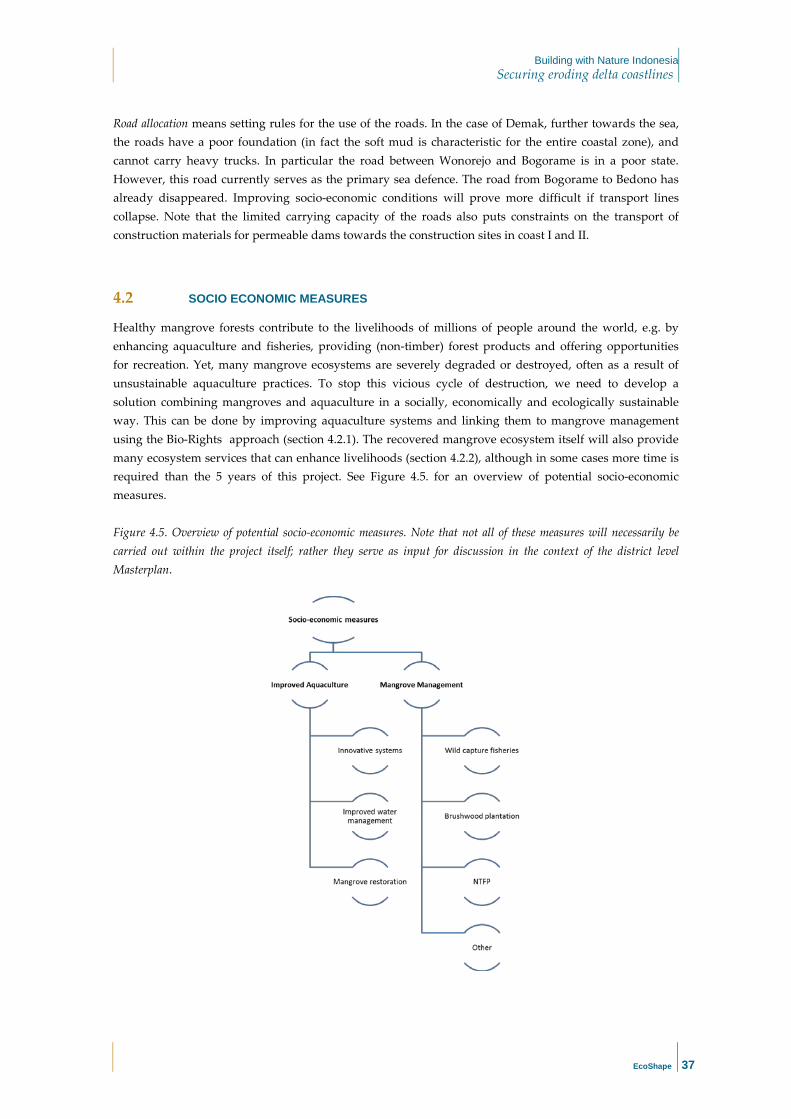
Building with Nature Indonesia Securing eroding delta coastlines
EcoShape
37
Road allocation means setting rules for the use of the roads. In the case of Demak, further towards the sea, the roads have a poor foundation (in fact the soft mud is characteristic for the entire coastal zone), and cannot carry heavy trucks. In particular the road between Wonorejo and Bogorame is in a poor state. However, this road currently serves as the primary sea defence. The road from Bogorame to Bedono has already disappeared. Improving socio-economic conditions will prove more difficult if transport lines collapse. Note that the limited carrying capacity of the roads also puts constraints on the transport of construction materials for permeable dams towards the construction sites in coast I and II.
4.2 SOCIO ECONOMIC MEASURES
Healthy mangrove forests contribute to the livelihoods of millions of people around the world, e.g. by enhancing aquaculture and fisheries, providing (non-timber) forest products and offering opportunities for recreation. Yet, many mangrove ecosystems are severely degraded or destroyed, often as a result of unsustainable aquaculture practices. To stop this vicious cycle of destruction, we need to develop a solution combining mangroves and aquaculture in a socially, economically and ecologically sustainable way. This can be done by improving aquaculture systems and linking them to mangrove management using the Bio-Rights approach (section 4.2.1). The recovered mangrove ecosystem itself will also provide many ecosystem services that can enhance livelihoods (section 4.2.2), although in some cases more time is required than the 5 years of this project. See Figure 4.5. for an overview of potential socio-economic measures. Figure 4.5. Overview of potential socio-economic measures. Note that not all of these measures will necessarily be carried out within the project itself; rather they serve as input for discussion in the context of the district level Masterplan.

Building with Nature Indonesia Securing eroding delta coastlines
EcoShape
38
4.2.1 IMPROVED AQUACULTURE
4.2.1.1 INNOVATIVE SYSTEMS
The present generation of inhabitants in the coastal communes of Demak district has specialised in aquaculture, some people still practice traditional fisheries and most lost skills in cropping rice. Therefore aquaculture offers the best option for short term improvements in livelihoods. Several species that are already cultured in Demak - tiger shrimp, white legged shrimp, milkfish and tilapia – in particular offer opportunities to enhance productivity and income. This is because their market price is high, they are not sensitive to pollution/salinity and/or they are suitable for cultivation in extensive poly-culture systems. The latter is important because this allows implementation of so-called multi-trophic aquaculture systems in which farmers stock multiple species which stimulates nutrient recycling and hence limits pollution. Careful ‘species-to-site’ matching needs to be undertaken and indicative biophysical and other requirements for cultivation of each of the specific aquaculture options are listed in Annex 1. Table 4.1: Aquatic species already cultured in Demak district. Species General conditions
Tiger shrimp; Penaeus monodon
White legged shrimp; Litopenaeus vannamei
Milkfish; Chanos chanos
Tilapia; Oreochromis mossambicus
Motivation High market price and fits in
polyculture systems.
Good price and short grow-out period.
Not very sensitive to polluted water and
pond. Tolerates wide ranges of salinity.
Indicated for green-water filter ponds;
evasive risk when not endogenous.
Production systems
Earthen ponds Lined ponds
Silvo-aquaculture
Lined ponds Earthen ponds
Earthen ponds Lined ponds
Net pens Cages
Earthen ponds Lined ponds
Net pens Cages
Some aquatic species that are new to the district may also be suitable and can be introduced, although this requires more investment, training and sometimes on-farm research. Species that merit specific attention are: (soft shell) mud crab, blue swimming crab, seaweed, Asian green mussel, blood cockle, flat head grey mullet, Catfish. In some hamlets of coast I and 0 the blue swimming crab is caught at present. The market demand and price is high and thus its aquaculture has prospects. See Annex 2 for the required biophysical conditions. We conservatively assume the same improvement of income as above: 2.5 times the present income from aquaculture. The intensity of pond management determines the shrimp yield. To decrease disease risk we propose a semi-intensive system with an ecological management regime, using a filter pond to prepare clean water for the shrimp ponds 32, see Figure 4.6. The aquatic organisms harvested from this so-called green-water pond moreover contribute to farm households’ nutritional food security 33. If the pond area owned by the farmer is too small, the tilapia can be raised in nets inside his/her pond. Productivity of the various aquaculture systems can moreover be improved by regularly cleaning the pond bottoms (curing), improving infrastructure for pond drainage (system of sluices and pumps), and applying aeration and by training the farmers in Coastal Field Schools. As mentioned in Chapter 2, shrimp yield and the annual profit per hectare can almost double when the farmers participate in a Coastal Field School. The yield of tiger shrimp can reach 400 kg/ha without using aerators, and easily become ten-fold (4000 kg/ha) when aerators are used. Though the yield of white legged shrimp can be ten-fold of the last, cost and risk increase also.

Building with Nature Indonesia Securing eroding delta coastlines
EcoShape
39
Figure 4.6: Design of an improved green-water shrimp systems 30. Black = road, brown = homestead, dark green = earthen dikes, light green = ´green water´ pond, clean water indicated in blue and waste water in green.
4.2.1.2 IMPROVED WATER MANAGEMENT
In view of land subsidence, projected sea level rise, and the degraded state of the water management system, improved water management is needed to be able to continue using the land behind the envisioned mangrove greenbelt for aquaculture. Infrastructures will need to be heightened and a drainage plan for all waste water is required to prevent the area from becoming a ´bath tub´. Also, to prevent further subsidence, fresh water extraction from groundwater wells needs to be avoided and ponds need to make optimal use of surface freshwater flows. Primary canals may be needed in some cases to provide water for the fish ponds. Linking ponds to the primary canals should be a private investment that may be supported by the bio-rights approach. Pumps may be needed to evacuate water from ponds and drainage canals in places where land subsidence limits water evacuation. Many of these issues are public works and need to be addressed at the district level, as supported by a Masterplan. Pond layout may need to be adjusted, so that dikes have separate sluice-gates for water inlet and outlet. Further, to reduce the disease impact when farmers want to intensify, the white legged shrimp and tiger shrimp are best cultured in so-called green-water shrimp systems using tilapia to filter the water (and perhaps also sea bass in another pond). The implementation of this more sustainable green-water shrimp system requires investment in separate in and outlet canals with sluice gates for all ponds. In the short term, the mixed mangrove-aquaculture system can be introduced along rivers to further reduce the spread of disease agents and purify water. In the long term this system can also be introduced behind the restored coastal greenbelt. Specific attention needs to be given towards nutrient dynamics and nutrient recycling. The lay-out of the aquaculture system will need to be optimised in order to maximise the internal productivity while minimising the environmental impact 31,32. Furthermore, the efficiency of natural feeds present in the mangrove-shrimp system in combination with purposely formulated artificial feeds will be evaluated in terms of shrimp growth, survival and other production parameters 33.

Building with Nature Indonesia Securing eroding delta coastlines
EcoShape
40
4.2.1.3 MANGROVE RESTORATION
All the above mentioned aquaculture systems can directly be combined with mangroves, in an innovative mixed mangrove-aquaculture system (Figure 4.7). This system is different from the silvofisheries system that is often applied in Indonesia, because the mangroves and aquaculture ponds are separated. Due to this separation, aquaculture productivity and management is optimal, while the surrounding mangroves reduce the spread of disease agents, purify water and moreover maintain their coastal safety and fisheries enhancement functions. Silvofishery systems in which trees are planted on the bunds hardly provide mangrove ecosystem services, apart from reducing erosion of the bunds. Mangroves that are planted inside ponds are separated from the surrounding open water and hence cannot help to filter water nor provide food and shelter for fish species. Figure 4.7: Design of a mixed mangrove-aquaculture system, maintaining mangroves ecosystem functions and allowing to optimise shrimp production 30. Black = road, brown = homestead, dark green = earthen dikes, light green = ´green water´ pond, clean water indicated in blue and waste water in green. Introduction of the mixed mangrove system requires adjustment of the pond layout, notably to free up space for a mangrove greenbelt of ideally 50 m wide along the river. Thereto a new dike needs to be built, and on the waterside the dike needs to be broken and (part of) the land brought to a level appropriate for natural mangrove recovery, while keeping/making ditches for the pond water inlets.
Through the Bio-Rights approach, aquaculture revitalisation in the ‘aquaculture zone’ in the hinterland can also be more indirectly linked to mangrove restoration in the ‘greenbelt zone’ at the seafront.

Building with Nature Indonesia Securing eroding delta coastlines
EcoShape
41
4.2.2 OTHER SOCIO-ECONOMIC MEASURES
4.2.2.1 WILD CAPTURE FISHERIES
A restored mangrove landscape may enhance the catches of marine fisheries. Therefore fishermen can be mobilised also for mangrove recovery; at least if they will be allowed to fish with gears appropriate for catching the positively affected species. Also, wild capture fisheries may complement income from aquaculture. Many of the most valuable coastal fish (snappers, sciaenids) and shellfish (shrimp and crab) resources of the Demak area display sequential life-cycle migration 34 as well as diadromous (migratory between fresh and salt water) life history habits (Fig. 4.2). Consequently, restoration of these key socio-economic resources requires the presence of not only sufficient suitable habitat for each life phase but also functioning ecological connectivity between these habitats. Fig 4.2. Snappers (Freshwater snapper, Lutjanus fuscensis and Blackspot snapper, Lutjanus ehrenbergii, barramundi, Lates calcarifer, and Philippine catfish, Clarias batrachus) caught by hook and line in a mangrove channel. All four of these species estuarine species are closely tied to mangrove systems and require land-sea aquatic ecosystem connectivity.
4.2.2.2 BRUSHWOOD, NTFP AND OTHER
In the framework of sustainable sourcing of materials for the permeable dams, we will explore the potential to source brushwood locally by stimulating the set-up of brushwood plantations in Demak. Brushwood plantations may then become an alternative livelihood or an additional source of income for the communities. This option is explored further in the hardware plan (Result 1.6).

Building with Nature Indonesia Securing eroding delta coastlines
EcoShape
42
In the short term, non-timber forest products (NTFP), like handy crafts, honey and sugar (where Nypah palm grows), can be developed in the restored mangroves to complement income. Also, fuel wood and fodder may be collected. In the longer term timber may be extracted at the landward side of the greenbelt, carefully regulated to ensure that this does not undermine coastal safety. Figure 4.3. Mangroves are among the most valuable ecosystems globally, offering a myriad of so-called ecosystem services.
In areas where land has not subsided but the reduced fresh water availability, i.e. salinity, has become a constraint for rice culture the possibility to introduce salt tolerant quinoa, potato or other dryland crops might be tested. After successful testing of quinoa and potato this requires the establishment of regulated value chains that pay their contribution to the patented seed breeders and the indigenous owners, as well as training of extension workers, producers, input providers and traders. Thus, the introduction of new dryland crops is also a long term option (outside the scope of the current project). In areas where land has subsided the options for agriculture are limited, which is not only due to salinization, but also because of the reduced possibility to drain (irrigation) water. Here the mangrove products, and in worst case fisheries, become an option.

Building with Nature Indonesia Securing eroding delta coastlines
EcoShape
43
5 Spatial Design
5.1 MISSION STATEMENT METHODOLOGY
To determine the right combination of coastal safety and socio-economic measures (described in Chapter 4) that is needed at a specific location, we translate the overall Demak vision into a more specific mission statements for each of the coastal zones identified in Chapter 2. This mission statement takes into account the specific biophysical and socio-economic opportunities and constraints present, which in turn leads to a prioritization of measures. In determining our mission statements, we followed the shoreline management terminology as defined by the UK Environmental Agency (Box 5.1).
5.2 SPATIAL DESIGNS PER COASTAL ZONE
The next sections summarise the current status, proposes a mission and selects measures to achieve that mission. Further, a spatial design of measures is presented. For detailed designs of the measures themselves, as well as a discussion of materials, maintenance and budget involved, we refer to the hardware plan (result 1.6).
5.3 COAST 0 FROM SURODADI UP TO THE WULAN DELTA
5.3.1 CURRENT STATUS
In this coastal zone, the protective greenbelt is mostly lost and aquaculture ponds extend into the intertidal zone almost up until the chenier. In the Wulan delta and around accretion is observed in the last decade.
Box 5.1. UK Environmental Agency distinguishes the following interventions • No active intervention – There is no planned investment in defending against
flooding or erosion, whether or not an artificial defence has existed previously. • Hold the line – An aspiration to build or maintain artificial defences so that the
position of the shoreline remains. Sometimes, the type or method of defence may change to achieve this result.
• Managed realignment – Allowing the shoreline to move naturally, but managing the process to direct it in certain areas. This is usually done in low-lying areas, but may occasionally apply to cliffs.
• Advance the line – New defences are built on the seaward side.

Building with Nature Indonesia Securing eroding delta coastlines
EcoShape
44
South of the Wulan delta there are some signs of erosion. A few patches of pioneer mangroves exist and mangrove recovery is probably inhibited mainly by lack of space in the intertidal and by lack of hydrological connectivity (due to presence of bunds). Subsidence is expected to be relatively low. Cheniers are still present and are relatively high and wide. Aquaculture ponds are farmed extensively. The dominant activities in most communities are related to aquaculture and fisheries.
5.3.2 PROPOSED MISSION
Given that currently there is no greenbelt and (unproductive or abandoned) aquaculture ponds are present up to the seafront, it is our proposed mission to:
Hold the line, by in the longer term converting aquaculture ponds at the seafront into a mangrove greenbelt for coastal safety as compensated for by revitalizing aquaculture in the hinterland in the short term.
This proposed mission is illustrated in Figure 5.1, representing a close up of the overall vision for Demak. Figure 5.1. Proposed mission for coast 0, as input for dialogue on a Masterplan for Demak district and as a basis for the measures proposed in this plan.
5.3.3 PROPOSED MEASURES AND SPATIAL DESIGN 2015-2019
In coast 0, building out and restoring mangrove seawards is not an option, as the mangroves and coast already lies close to the chenier. For restoration of the greenbelt people thus need to sacrifice aquaculture ponds that lie close to the sea or close to the river. The challenge in realization is not so much technically, but lies in convincing and collaboration with the local stakeholders. Hence, in the longer term, we envisage restoration of the protecting mangrove green-belt, while in the short term sustainable and more

Building with Nature Indonesia Securing eroding delta coastlines
EcoShape
45
productive aquaculture will be developed in the aquaculture zone. A successful showcase for ecological mangrove restoration in the greenbelt zone in conjunction with aquaculture revitalization in the hinterland is essential in this. Setting up mixed mangrove systems along rivers will also be valuable as a showcase. Coastal development in coast 0 will be closely monitored to assess the need for mitigation measures. If coastal erosion in this area accelerates protective permeable dams may need to be constructed. A detailed spatial design for the aquaculture measures will necessarily need to be developed in close collaboration with the community members, as part of the Coastal Field School and Bio-Rights approach. This project will contribute in the following way towards achieving the mission for coast 0: Greenbelt zone Aquaculture zone Sub-result 2.4: no coastal safety target defined in coast 0, potential to leverage mangrove rehabilitation through Bio-Rights approach will be explored. Measures: - Feasibility Assessment
Sub-result 2.5: ~150 ha revitalised aquaculture; of which ~25 ha mixed mangrove-aquaculture system Measures: - Improved water management (150 ha) - Introduction of innovative multi-trophic aquaculture systems (~150 ha) - Introduction of mixed mangrove-aquaculture system (~25 ha) - Assisted natural mangrove regeneration/ enrichment planting in mixed mangrove aquaculture system (~ 15 ha)
5.4 COAST I/II FROM BEDONO TO SURODADI
5.4.1 CURRENT STATUS
The protective greenbelt is lost and coastal erosion is proceeding rapidly. Erosion and subsidence are severe. A few patches of (eroding) young pioneer mangroves exist, and mangrove recovery is mainly limited by elevation/submergence time and wave exposure. The road functions as primary flood defence and is about to collapse or has already (partly) collapsed. In areas where the road has already disappeared erosion has protruded farther inland along the rivers. Fine sediment availability close to the coast is decreasing because it is transported offshore to deeper water, where it cannot be mobilized anymore by offshore waves (but could become available through mud nourishment). Cheniers are still present but small and low and likely declining. Some aquaculture, mostly milkfish, is still practiced, but ponds are largely unproductive due to pollution, impaired drainage and flooding caused by subsidence and erosion. Community members are starting to work in industry and construction rather than in aquaculture or fisheries sectors.

Building with Nature Indonesia Securing eroding delta coastlines
EcoShape
46
5.4.2 PROPOSED MISSION
Given that a greenbelt is lacking and that erosion has taken hundreds of meters of aquaculture ponds, our proposed mission is to:
Advance the line, by restoring the conditions for a mangrove greenbelt and then revitalizing aquaculture in the hinterland to avoid return to aquaculture in the greenbelt zone.
This proposed mission is illustrated in Figure 5.2, representing a close up of the overall vision for Demak. An important physical limitation is the amount of fine sediments available for regaining eroded land (see Chapter 2). This means that in coast I/II it is likely that part of the originally present sediment is already lost to deeper water. Therefore, restoration of the coastline to its position in 2003 is not considered feasible within the scope of this project. A coastline that is positioned in between the current and the 2003 coastline is a more realistic mission in coast I/II, see the purple line in Figure 5.2. The exact boundary between coast I/II and III is still to be determined and depends on field surveys, ongoing erosion and subsidence trends and available funding. The boundary is now marked as a ‘buffer zone’. Figure 5.2. Proposed mission for coast I/II, as input for dialogue on a Masterplan for Demak district and as a basis for the measures proposed in this plan.

Building with Nature Indonesia Securing eroding delta coastlines
EcoShape
47
5.4.3 PROPOSED MEASURES
To restore the mangrove greenbelt the coastline will need to advance through construction of permeable dams for sediment trapping and restoration of the mangrove habitat. The current coastal slope between the coastline and the chenier is around 1:600 (Figure 5.3). In muddy coastlines with mangrove systems, slopes are generally between 1:1000 and 1:1500. The far steeper slope in the Demak area shows the urgency to rapidly start restoration of the coast. The aim is to fill in the coastal profile between the coastline and the chenier as much as possible, but it is questionable whether sufficient sediment is still present in the system. An estimate of the restored profile is depicted in figure 5.3. The current profile in the figure needs to be elevated starting at the existing coastline using permeable dams to trap sediment. Mangroves have been reported to start colonizing slightly about mean sea level in this area and have shown to develop into a small forest within 3 years. Restoration of the original coastal profile in this area that likely was convex and gradually sloping is not considered realistic due to long-term changes that have been taking place in the coastal system that influence sediment availability and chenier elevation and width. In addition, the chenier will probably be mobile and disperse towards the coast during the storm season.
Figure 5.3 The current coastal profile relative to mean sea level and potentially restored profiles in 2017 and 2020. The reference profile is an idealized convex coastal profile.
The envisioned greenbelt width is between 500 and 1000 metres. However, the exact width of the zone to be restored is determined on the project by learning by doing and depends on the available space to the front from the current coastline and on the available amount of sediment. The coastline will not be advanced further than hundred meters behind the present chenier. If recovery is slow and mangroves have not established within the first year behind the permeable dams, additional measures to speed up coastal restoration will be considered. Such additional measures are for example chenier nourishment with sand, mud nourishment behind the chenier and improving drainage by creek creation. If the restoration

Building with Nature Indonesia Securing eroding delta coastlines
EcoShape
48
space between the current coastline and the chenier is smaller than 500 metres, managed realignment will be considered. However, if vital infrastructure or villages are present, smaller mangrove forests may have to be combined with hard defences, such as already present seawalls or earthen levees. The mangrove area to be developed should be protected against other activities, such as aquaculture pond construction. In addition to that, digging of deep aquaculture ponds just next to main roads will jeopardize the integrity of the road. Mangrove restoration along river land inward is considered a prerequisite for a resilient mangrove system, as the inland system will provide the source of seeds for succession of the fronting mangrove forest. Given the current land-use (aquacultures), innovative mixed mangrove aquaculture systems will be introduced and/or incentives for local communities to convert their ponds to mangrove stands will be set up. As such, mangrove restoration is integrated with aquaculture through the Bio-Rights approach. Mangrove restoration will follow the principles of ‘Ecological Mangrove Restoration’ as outlined in Chapter 4 and thus relies heavily on natural regeneration. However, we anticipate that planting of Rhizophora at strategic locations (e.g. on remaining pond bunds) in Coast I/II may stimulate generation of still water areas where sediment can settle and the pioneer species Avicennia can colonize naturally. As Indonesia has adopted a mangrove replantation program, we aim at steering these plantation activities to integrate with the construction of permeable dams. Summarising, this project will contribute in the following way towards achieving the mission for coast I/II: Greenbelt zone Aquaculture zone Sub-result 2.4: 90 ha mangrove Measures: - Permeable dams to restore sediment balance, spatial arrangement of dams stimulates creek rehabilitation - Mud nourishment to restore sediment balance - Sand nourishment to restore chenier - Assisted natural regeneration - Enrichment planting
Sub-result 2.5: ~150 ha revitalised aquaculture; of which ~25 ha mixed mangrove-aquaculture system Measures: - Improved water management (150 ha) - Introduction of innovative multi-trophic aquaculture systems (~150 ha) - Introduction of mixed mangrove-aquaculture system (~25 ha) - Assisted natural mangrove regeneration/ enrichment planting in mixed mangrove aquaculture system (~ 15 ha)
5.4.4 SPATIAL DESIGN 2015 - 2019
In Figure 5.4 we give a first impression of all permeable dams in coast I/II that are deemed necessary for restoration of the coastal greenbelt, on the basis of our current system understanding. As such, the spatial design represents measures that need to be taken up by all stakeholders, to be aligned in a Master Plan. A detailed spatial design for the aquaculture measures will necessarily need to be developed in close collaboration with the community members, as part of the Coastal Field School and Bio-Rights approach. Note that permeable dams should always be placed in the back of the area that has to be restored, advancing step by step in seaward direction instead of building several rows at once. If not, too little

Building with Nature Indonesia Securing eroding delta coastlines
EcoShape
49
sediment may be mobilized, and worse, large deposits further offshore are likely to reduce sedimentation rates in the back, yielding the risks of water logging. The exact location of the permeable dams further depends on field surveys. Dams will be constructed over different years with construction moments before the monsoon in the months September until November of the years 2015, 2016, 2017 and possibly 2018. Exact phasing and permeable dam placement may be subject to changes as each year, more information on system functioning will be gathered that requires us to optimize designs with respect to distance in between dams, length of dams, width of openings in dams, accretion levels within the dam areas and time and labour needed for construction of dams. The permeable dams need to be placed such that they enhance water management by stimulating the formation of creeks and rivers. Where possible, the dams should be placed on top or at the side of the bunds of abandoned ponds, as these are strong, hence minimizing local scour around the piles and underneath the brushwood. Hence, the proposed spatial design has taken the former position of aquaculture bunds into account. Figure 5.4. Tentative (!) spatial design of coastal safety measures in Coast I/II for 2015 – 2019, to be achieved by multiple stakeholders as aligned in a Masterplan.
Based on experiences with previous permeable dams, we anticipate about 0.5 m of siltation in the 2015/2016 monsoon period (December – February). If bed level is then sufficiently high for mangrove colonization, we will extend the building of permeable dams in 2016 outwards to the sea. The decision whether or not to build follows from our monitoring program, and is part of our adaptive approach. Similarly, erection of the other permeable dams is steered by the observations on siltation rates and mangrove rehabilitation. Likely, we build in steps, i.e. not the entire lengths at once. We will also test the efficiency of mud nourishment in 2016 or 2017 to bring more mud into the system and to accelerate siltation in strategic areas. The permeable dams need to stay in place long enough for mangroves to take over, which is a sum of the sediment accretion rate and rate of mangrove recovery (rates need to be monitored). Permeable dams at the target coastline are required to stay in place longer as they will continue to have a wave breaking function also after sediment has been trapped. Hence multi-year maintenance is needed.

Building with Nature Indonesia Securing eroding delta coastlines
EcoShape
50
5.4.5 PROPOSED MEASURES AND SPATIAL DESIGN 2015
Here we present a spatial design for all permeable dams to be constructed in 2015 in collaboration with MMAF (Figure 5.5). Figure 5.5. Spatial design of coastal safety measures in Coast I/II planned for 2015, in collaboration with MMAF.
The coastal safety measures in 2015 are aimed at:
1. Safeguarding the villages Timbul Sloko and Bedono, and the road in between, 2. Safeguarding existing mangrove patches, as these can serve as a nucleus for mangrove
reforestation. Therefore, in 2015 it is a key priority to build a permeable brushwood dam in front of the road that is connected to existing permeable dams. This dam is meant to protect the road and the villages. Alongside the construction of this permeable dam, awareness in the community will need be raised about the danger of excavating shrimp ponds next to vital infrastructure and how this will trigger the collapse of infrastructure.
The outer two permeable brushwood dams (number 3 and 4) are along the target coastline (indicated by the purple line). The purpose of these permeable dams is to protect the mangrove forests from further erosion. Locations 3 and 10 are suitable for testing of materials, as these two locations are most exposed to wind and waves and thus represent the most adverse conditions that dams need to be able to withstand (see also the hardware plan, result 1.6). The black line represents existing permeable dams that are repaired by MMAF, while the blue lines represent the new permeable dams that MMAF will construct in 2015. The blue lines have a total length of 1600 m. The Ecoshape consortium will repair two existing structures (white lines) and will further construct the permeable dams represented by the orange and white lines, which will be approximately 700 m.

Building with Nature Indonesia Securing eroding delta coastlines
EcoShape
51
5.5 COAST III FROM BEDONO TO SEMARANG
5.5.1 CURRENT STATUS
The protective greenbelt is lost. Very few patches of (eroding) young pioneer mangroves are still present. Mangrove recovery is limited by too large depths, a lack of fine sediment and wave exposure. Erosion and subsidence are very severe and kilometres of land have been lost, including many aquaculture ponds and two villages. Most farmers practice extensive aquaculture (milkfish, shrimp) in destroyed netted ponds, which are permanently flooded due to subsidence and erosion. In destroyed ponds on the sea side nets and other fishery devices are being operated. Some of these destroyed ponds are abandoned because renters/owners found another livelihood, or the available water is too dirty, and/or drainage impaired.
5.5.2 PROPOSED MISSION
In view of the severity of erosion and subsidence and the peri-urban nature of Coast III, our proposed mission is:
Managed realignment, by starting a multi-stakeholder dialogue about re-alignment of the coastline to a more landward position and about suitable Building with Nature approaches to enhance coastal safety.
This proposed mission is illustrated in Figure 5.6, representing a close up of the overall vision for Demak. The exact boundary between coast II and III is still to be determined and depends on field surveys, ongoing erosion and subsidence trends and available funding. Hence the boundary is marked as a buffer zone. Figure 5.6. Proposed mission for coast III, as input for dialogue on a Masterplan for Demak district.

Building with Nature Indonesia Securing eroding delta coastlines
EcoShape
52
5.5.3 PROPOSED MEASURES
For coast III the aim is to initiate a multi-stakeholder dialogue that will focus on possible strategies for this coastal stretch. Possibly the present road needs to be re-allocated and/or a polder needs to be established. Hard measures and seawalls in this area can be accompanied by the restoration of a mangrove forest in front of the hard measures to minimize wave impacts. Sustainability of this mangrove depends on subsidence rates and sediment availability. Within this project, facilitating the dialogue that is needed to protect this area and come up with a viable strategy is our main target for coast III. This dialogue will start during phase 2 of the study. For other types of restoration measures, such as permeable dams, subsidence and lack of sediment are considered too severe in this coastal stretch. Moreover, the coast has retreated largely, so it is not clear whether sufficient sediment will be able to reach the back. Starting permeable dams from the front is inadvisable as they will increase sediment trapping on the front, but this will create an inverse elevation gradient in this coastal area. Large-scale infilling with sediment in the back is potentially possible, provided sufficient sediment is available, but comes with enormous costs. In addition, permeable dams on large-scale need to be built to keep this sediment in place and continuous nourishment is needed to counteract facts of rapid subsidence in this area. Development of a spatial design for coast III is outside the scope of the current project.

Building with Nature Indonesia Securing eroding delta coastlines
EcoShape
53
6 Planning
6.1 PRIORITISATION AND ADAPTIVE MANAGEMENT CYCLE
Since it is the local communities that eventually need to sustain the restored mangrove greenbelt, mangrove restoration will in all cases need to go hand in hand with measures to enhance their prosperity. Enhancement of economic activities is realized through the introduction of sustainable and productive aquaculture and fisheries directly or indirectly linked to mangroves, and of other coastal livelihood activities. However, because a lack of coastal safety is currently directly undermining the local economy in many places, protecting those villages and infrastructure (roads) that are under direct threat from erosion is necessarily our first priority. If these villages and their inhabitants are gone, the socio-economic drivers for coastal restoration are lost.
Figure 5.7. represents our yearly adaptive planning cycle. The monsoon months are indicated with dark blue circles. In these months, nature will do its work. After the monsoon, monitoring data will be processed and analysed. This then, forms the basis for an updated design of coastal safety and socio-economic measures, as reflected in an updated design and engineering plan as accompanied by an updated hardware plan. To enable alignment with government, a draft design needs to be available already in April, while the final design needs to be available end of May at the latest. In June and July operational project monitoring and evaluation will take place (see result 1.7) and preparations for the next round of implementations will start so that the next round of measures can be implemented before the start of the monsoon. Note that implementation of socio-economic measures will follow the rhythm of the respective aquaculture systems, as these rhythms can vary widely they are not captured in the planning circle. Figure 5.7. Adaptive planning cycle.

Building with Nature Indonesia Securing eroding delta coastlines
EcoShape
54
6.2 ANNUAL PROJECT TARGETS
The annual project targets for implementation of the Building with Nature demonstration project (flagship) in Demak are summarised in Table 6.1. Table 6.1 Annual project targets (result 2). * target to be updated annually on the basis of real needs and alignment with stakeholders, as part of adaptive management
Sub-result Baseline Target values (cumulative)
May 2015 May 2016 May 2017 May 2018 May 2019 May 2020
2.1 Design of Building with Nature application for 20 km shoreline in Demak completed, including detailed work plan on the basis of identified bio-physical and socio-economic design requirements; shared with stakeholders
Design ready (Result 1.5)
Design updated
Design updated
Design updated
Design updated
Design updated
2.2 Agreements with community
groups 0 3 8 10 10 10
2.3 Agreements with contractors, following tender procedure
0 tbd in 2.1 tbd in 2.1 tbd in 2.1 tbd in 2.1 tbd in 2.1
2.4 Technical Building with Nature measures (mangrove rehabilitation, establishment of semi-permeable groynes, sediment nourishment works) are implemented, monitored and maintained together with Indonesian contractors, government and 10 local community groups
0 km dams 0,7 km 3 km* 9 km* 9 km* 9 km*
0 m3 mud 300000* 0 ha mangrove
40 ha 60 ha 90 ha
0 ha safe 6000 ha
safe
2.5 Socio-economic Building with Nature measures are implemented, monitored and maintained, supporting 10 community groups to revitalise 300 ha of degraded aquaculture ponds through enhanced pond operations, mangrove rehabilitation and livelihoods diversification
47 kg/ha to increase
with 50 % in 300 ha
25 ha 50 ha 100 ha 200 ha 300 ha with 70 kg/ha
19 million IPR/yr. income to increase with 25% in 300 hh
25 million IRP/yr. in 300 hh
2.6 Evaluate impact of implemented BwN solution: results monitored with local stakeholders on the basis of monitoring protocol and captured in knowledge base, documenting socio-economic, institutional, ecological and morpho-dynamic aspects
Baseline report (result 1.7) available
Technical M&E report available
Technical M&E report available
Technical M&E report available
Technical M&E report available
Technical M&E report available

Building with Nature Indonesia Securing eroding delta coastlines
EcoShape
55
References
1. Winterwerp, J., Erftemeijer, P. L. A., Suryadiputra, N., van Eijk, P. & Zhang, L. Defining eco-morphodynamic
requirements for rehabilitating eroding mangrove-mud coasts. Wetlands 33, 515–526 (2013).
2. Rahmawati, N. & Marfai, M. A. Salinity Pattern in Semarang Coastal City. Indones. J. Geol. 8, 111–120 (2013).
3. McIvor, A., Möller, I., Spencer, T. & Spalding, M. Reduction of Wind and Swell Waves by Mangroves. Natural
Coastal Protection Series (2012). at <http://www.naturalcoastalprotection.org/documents/reduction-of-wind-and-
swell-waves-by-mangroves>
4. McIvor, A., Spencer, T. & Möller, I. The response of mangrove soil surface elevation to sea level rise. Nat. Coast.
Prot. Ser. 1–59 (2013).
5. Lugo, A. & Snedaker, S. The ecology of mangroves. Annu. Rev. Ecol. Syst. 5, 39–64 (1974).
6. Tomascik, T., Mah, A. J., Nontji, A. & Moosa, M. K. The Ecology of the Indonesian Seas. (Oxford University Press,
1997). at <https://books.google.fr/books?id=0Kc80Hd2HagC>
7. MMAF. Presentation by MMAF on vulnerability of Central Java. (2013).
8. Brown, B. & Fadillah, R. Fish Farmer Field School-Towards Healthier Milkfish/Shrimp Polyculture and Fish
Farmer Empowerment in South Sulawesi. Aquac. Asia (2013). at
<https://scholar.google.fr/scholar?hl=fr&q=Ben+Brown+and+Ratna+Fadillah%2C+2013&btnG=&lr=#0>
9. Barbier, E. B. et al. The value of estuarine and coastal ecosystem services. Ecol. Monogr. 81, 169–193 (2011).
10. Robertson, A. & Alongi, D. Tropical Mangrove Ecosystems. Coastal and Estuarine Studies. 41. (1992). at
<http://epubs.aims.gov.au/handle/11068/425>
11. Rönnbäck, P. The ecological basis for economic value of seafood production supported by mangrove
ecosystems. Ecol. Econ. (1999). at <http://www.sciencedirect.com/science/article/pii/S0921800999000166>
12. Li, N. et al. Effect of NaCl on photosynthesis, salt accumulation and ion compartmentation in two mangrove
species, Kandelia candel and Bruguiera gymnorhiza. Aquat. Bot. (2008). at
<http://www.sciencedirect.com/science/article/pii/S0304377007001799>
13. Mazda, Y., Magi, M., Ikeda, Y., Kurokawa, T. & Asano, T. Wave reduction in a mangrove forest dominated by
Sonneratia sp. Wetl. Ecol. Manag. 14, 365–378 (2006).
14. Mendez, F. J. & Losada, I. J. An empirical model to estimate the propagation of random breaking and
nonbreaking waves over vegetation fields. Coast. Eng. 51, 103–118 (2004).
15. Balke, T. et al. Seedling establishment in a dynamic sedimentary environment: a conceptual framework using
mangroves. J. Appl. Ecol. 740–747 (2013). at <http://onlinelibrary.wiley.com/doi/10.1111/1365-2664.12067/full>
16. Faridah-Hanum, I., Latiff, A., Hakeem, K. & Ozturk, M. Mangrove Ecosystems of Asia. (2014). at
<http://link.springer.com/content/pdf/10.1007/978-1-4614-8582-7.pdf>
17. Van Eijk, P. & Kumar, R. Bio-rights in theory and practice. Wetlands International (2009). at
<https://scholar.google.fr/scholar?q=Eijk%2C+P.+van+%26+R.+Kumar%2C+2009&btnG=&hl=fr&as_sdt=0%2C5
#0>
18. Stanley, O. D. in Recent Advances in Biodiversity of India (eds. Raghunathan, C., Sivaperuman, C. &
Venkataraman, K.) 103–111 (Zoological Survey Of India, 2011).
19. Bradshaw, A. D. Restoration: an acid test for ecology. (1987). at
<https://scholar.google.fr/scholar?q=Bradshaw%2C+1987+&btnG=&hl=fr&as_sdt=0%2C5#0>
20. Bradshaw, A. Underlying principles of restoration. Can. J. Fish. Aquat. Sci. 53, 3–9 (1996).
21. Brown, B. & Lewis, R. R. Five Steps to Successful Ecological Restoration of Mangroves. Mangrove Action Project
(2006). at
<https://scholar.google.fr/scholar?q=Brown+and+Lewis+2006+mangrove+restoration&btnG=&hl=fr&as_sdt=0%
2C5#1>
22. Kamali, B. & Hashim, R. Mangrove restoration without planting. Ecol. Eng. 37, 387–391 (2011).

Building with Nature Indonesia Securing eroding delta coastlines
EcoShape
56
23. Lewis, R. R. Ecological engineering for successful management and restoration of mangrove forests. Ecol. Eng.
24, 403–418 (2005).
24. Lewis, R. R. & Streever, W. Restoration of Mangrove Habitat. Tech Note ERDC TN-WRP-VN-RS-3. US Army,
Corps Eng. Waterw. Exp. … (2000). at
<https://scholar.google.fr/scholar?hl=fr&q=Lewis%2C+R.+R.%2C+%26+Streever%2C+W.+%282000%29.+Restora
tion+of+Mangrove+Habitat.+&btnG=&lr=#0>
25. Valentine-Rose, L. & Layman, C. Response of fish assemblage structure and function following restoration of
two small Bahamian tidal creeks. Restor. Ecol. 19, 205–215 (2011).
26. Lee, S. Y. et al. Ecological role and services of tropical mangrove ecosystems: a reassessment. Glob. Ecol.
Biogeogr. 23, 726–743 (2014).
27. Sukardjo, S., Alongi, D. M. & Ulumuddin, Y. Mangrove community structure and regeneration potential on a
rapidly expanding, river delta in Java. Trees 28, 1105–1113 (2014).
28. Hinrichs, S., Nordhaus, I. & Geist, S. Status, diversity and distribution patterns of mangrove vegetation in the
Segara Anakan lagoon, Java, Indonesia. Reg. Environ. Chang. 9, 275–289 (2009).
29. Spalding, M., McIvor, A., Tonneijck, F. H., Tol, S. & van Eijk, P. Mangroves for Coastal Resilience. Wetlands
International and The Nature Conservancy (2014).
30. Bosma, R. H., Nguyen, T. H., Siahainenia, A. J., Tran, H. T. P. & Tran, H. N. Shrimp-based livelihoods in
mangrove silvo-aquaculture farming systems. Rev. Aquac. 6, 1–18 (2014).
31. Nhan, D. The role of a fish pond in optimizing nutrient flows in integrated agriculture-aquaculture farming
systems. (Wageningen University, 2007). at <http://edepot.wur.nl/22684>
32. Phong, L. Dynamics of sustainability in Integrated Agriculture-Aquaculture systems in the Mekong Delta.
(Wageningen University, 2010). at <http://library.wur.nl/WebQuery/clc/1937012>
33. Trong, T., Ngoc, V., Nguyen, K. & Rothuis, A. Improvement of traditional shrimp culture in the Mekong Delta.
Naga, ICLARM Q. 17, 20–22 (1994).
34. Cocheret de la Morinière, E., Pollux, B. J. A., Nagelkerken, I. & van der Velde, G. Post-settlement Life Cycle
Migration Patterns and Habitat Preference of Coral Reef Fish that use Seagrass and Mangrove Habitats as
Nurseries. Estuar. Coast. Shelf Sci. 55, 309–321 (2002).

Building with Nature Indonesia Securing eroding delta coastlines
EcoShape
57
Annex 1: Aquatic species already cultured in Demak district
Species
Tiger shrimp; Penaeus monodon
White legged shrimp; Litopenaeus vannamei
Milkfish; Chanos chanos
Tilapia; Oreochromis mossambicus
Motivation High market price and fits in polyculture systems.
Good price and short grow-out period.
Not very sensitive to polluted water and pond. Extremely euryhaline.
Indicated for green-water filter ponds; evasive risk when not endogenous.
Production systems
Earthen ponds Lined ponds Silvo-aquaculture
Lined ponds Earthen ponds
Earthen ponds Lined ponds Net pens Cages
Earthen ponds Lined ponds Net pens Cages
Sites In and behind the intertidal zone Sandy soils for broodstock
Behind intertidal zone
Feeding requirements & habits
Opportunistic generalists
Omnivorous, feeds on almost anything: e.g. algae, insects, crustaceans, fishes.
Water quality requirements pH 7.5-8.5 6.8 to 8.7 Oxygen (mg/L) 5 to 6 4 to 12 3 to 5 Temp. Range (*C) >30 22-35 16-30 Salinity (g/L) 10 to 25 0-55 18 to 32 0 - 28 Alkalinity (mg/L) 100 Further reading SeafDec, 2007.
InfoTips on mangrove-friendly shrimp farming. http://hdl.handle.net/10862/633
Cultured Aquatic Species Information Programme Penaeus vannamei (Boone, 1931) FAO
FAO factsheet: http://www.fao.org/fishery/culturedspecies/Chanos_chanos/en http://www.fao.org/fishery/affris/species-profiles/milkfish/milkfish-home/en/
FAO factsheet: www.fao.org/fishery/species/2408/en
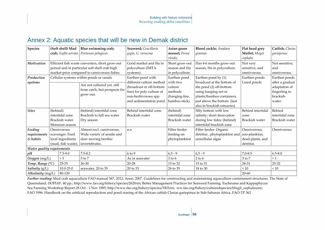
Building with Nature Indonesia Securing eroding delta coastlines
EcoShape
58
Annex 2: Aquatic species that will be new in Demak district Species (Soft shell) Mud
crab; Scylla serrata Blue swimming crab; Portunus pelagicus
Seaweed; Gracillaria gigas, G. verucosa
Asian green mussel; Perna viridis
Blood cockle; Anadara granosa
Flat head grey Mullet; Mugel cephalis
Catfish; Clarias gariepenus
Motivation Efficient fish waste converters, short grow-out period and in particular soft shell crab high market-price compared to carnivorous fishes.
Good market and fits in polyculture (IMTA systems).
Short grow-out season and fits in polyculture.
Has 4-6 months grow-out season, fits in polyculture.
Not very sensitive, and omnivorous.
Not sensitive, and omnivorous.
Production systems
Cellular systems within ponds or canals Earthen pond with different culture method (broadcast or off-bottom line) for poly-culture of non-herbivorous spp and sedimentation pond.
Earthen pond with two culture methods (hanging-line, bamboo stick).
Earthen pond by (1) broadcast at the bottom of the pond (2) off-bottom using hanging net or plastic/bamboo containers, just above the bottom (last also in brackish estuaries)
Earthen ponds Lined ponds
Earthen ponds after a gradual adaptation of fingerling to brackish water.
Are not cultured yet, still from catch, but prospects for grow-out.
Sites
(behind) intertidal zone Brackish water Monsoon season
(behind) intertidal zone Brackish to full sea water Dry season
Behind intertidal zone Brackish water
(behind) intertidal zone Brackish water
Silty bottom with low salinity; short desiccation during low tides; (behind) intertidal brackish zone
Behind intertidal zone Brackish water
Behind intertidal zone Brackish water
Feeding requirements & habits
Omnivorous scavenger. Feed local ingredients (snail, fish waste).
Almost excl. carnivorous. Wide variety of sessile and slow moving benthic invertebrates.
n.a Filter feeder feeding on phytoplankton
Filter feeder. Organic detritus , phytoplankton and unicellular algae
Omnivorous; zoo-plankton, dead plants, and detritus.
Omnivorous
Water quality requirements pH 7.5-9.0 7.5-8.2 6 to 9 6,5 - 9 6,5 - 9 7.0-8.5 6.5-8.0 Oxygen (mg/L) > 5 5 to 7 As in seawater 3 to 6 2 to 6 3 to 7 > 1 Temp. Range (*C) 25-35 26-30 20-28 15 to 32 15 to 31 28-31 25-32 Salinity (g/L) 10.0-25.0 seawater, 20 to 35 20 to 33 26 to 35 18 to 30 < 10 < 10 Alkalinity (mg/L) 80-120 20-60 Further reading: Mud crab aquaculture FAO manual 567, 2012; Anon. 2007. Guidelines for constructing and maintaining aquaculture containment structures. The State of Queensland, DOPIAF. 40 pp.; http://www.fao.org/fishery/species/2629/en; Better Management Practices for Seaweed Farming. Eucheuma and Kappaphycus Sea Farming Workshop Report 28 Oct - 1 Nov 1985; http://www.fao.org/fishery/species/3503/en; ww.fao.org/fishery/culturedspecies/Mugil_cephalus/en; FAO 1996. Handbook on the artificial reproduction and pond rearing of the African catfish Clarias gariepinus in Sub-Saharan Africa. FAO-TP 362

Building with Nature Indonesia Securing eroding delta coastlines
EcoShape
59
Annex 3 Bio-Rights Approach
INTRODUCTION
The Fishers of Timbulsloko village, Demak, Central Java, has been experienced with the lost or reducing sources of incomes from fishery sector, mainly due to the destroyed coastal zone resulted from the disappearance of natural mangrove belts. Current studies in the areas indicated that more destructions will remained to be continued further inland, and creating even more devastating loss (such as settlements and other infrastructures) unless coordinated and measured actions are rapidly taken. Other studies, however, also highlighted that large potential are still occur to ecologically restore the coastal condition through the establishment of more favourable habitat condition to bring the mangrove ecosystem back, either naturally or through human intervention. The recovered productive-mangrove ecosystem will provide the initial desired ecosystem services in about 10 – 20 years. They might re-provide both timber and non-timber forest products to contribute to the people’s livelihood. In the meantime, a shorter-term sustainable livelihood options are required for local communities, which both economically and ecologically suitable with the agreed overall longer-term restoration scenarios. In the project areas of Demak District, the revitalization of traditional aquaculture recognized as the best option for shorter-term livelihood improvement for local communities. In order to ensure that the sustainable livelihood improvement through the revitalization of aquaculture practices are having close linkage with the overall coastal restoration programme, the steps will be taken in accordance with the Bio-Rights mechanism. The Bio-Rights is referring to an innovative financial mechanism that addresses the reconciliation between poverty and environmental degradation, by providing conditional support to local communities. It serves as a payment scheme to the communities in return to their active engagement on the conservation and restoration of the natural environment. By providing direct or in-direct financial support (in this case support for the development of sustainable aquaculture), the approach will allow local communities to refrain from the currently unsustainable livelihood practices and initiated or be actively engaged on the environmental conservation and restoration initiatives (such as coastal restoration: the construction and maintenance of semi-permeable dam, and assisted mangrove regeneration). In addition, local communities will also actively engaged on the development of such (local) policies which will support the restoration works, for example the development of village level regulation on mangrove protection, DRR activities and establishment of village level disaster response team. The figure below indicates the general schematic mechanism of Bio-Rights approach which might be applied in accordance with the coastal restoration works. As a generic scheme, it may be adjusted into other schematic complexity according to the local setting condition.

Building with Nature Indonesia Securing eroding delta coastlines
EcoShape
60
As an incentive mechanism, the Bio-Rights approach can be embedded into BwN’s work of livelihood improvement on sustainable aquaculture through the following scheme/steps1. These steps will contribute to a win-win outcome of both improved community livelihood (i.e. sustainable aquaculture practices) and coastal restoration activities.
STEPS IN BIO-RIGHTS APPROACH
STEP 1.PROJECT INITIATION
In the context of Building with Nature, this step has been mainly done internally among project team, including the development of project’s logical framework and establishment of local management structure. Local community will be mainly engaged on identification of interested stakeholders, and development of network and first stakeholder consultation. This step will include:
• CONCEPT DEVELOPMENT AND ASSESSMENT OF APPROACH; • GENERATE FUNDS; • IDENTIFY INTERESTED STAKEHOLDERS; • SELECT PROJECT SITES; • NETWORK DEVELOPMENT AND STAKEHOLDER CONSULTATION; • RECRUITMENT OF BIO-RIGHTS TEAM MEMBERS; • TRAINING OF BIO-RIGHTS TEAM PERSONNEL
The idea of Bio-Rights is to introduce a new funding mechanism into local community groups. This will be done through series of meeting and interaction between Project Team members with interested stakeholders, including local government officials, village government and local communities. It is highly
1 For the full text of Bio-Rights approach please refers to Eijk, P. van & R.Kumar, 2009. Bio-Rights in theory and
practice.A financing mechanism for linking poverty alleviation and environmental conservation. Wetlands
International, Wageningen, the Netherlands.

Building with Nature Indonesia Securing eroding delta coastlines
EcoShape
61
required that all Project Team personnel has sufficient information and knowledge on i) Project background and information, ii) technical conservation and restoration techniques, iii) technical livelihood improvement – aquaculture, and iv) policy making process. Intensive training will be required prior to the implementation of the project, targeted to the Bio-Rights Team Personnel (Field Coordinator and Field Facilitator). The training programme needs to be developed as part of the training for trainers of Field School approach
STEP 2.PROJECT DEVELOPMENT.
This is the crucial part to start the implementation of Bio-Rights approach at community level. The level of Bio-Rights intervention success and sustainability will largely be determined by the level of local community’s engagement since the earlier development of the programme. This step includes:
• STAKEHOLDER CONSULTATION I: EXPLANATION OF CONCEPT, GROUP DEVELOPMENT;
• STAKEHOLDER CONSULTATION II: SET GOALS AND DEVELOP A PLAN; • FURTHER FIELD STUDIES (OPTIONAL); • FITTING BIO-RIGHTS PLAN IN GREATER CONTEXT;
Local communities are crucial determinants of success, given their direct involvement in the implementation of actual conservation and restoration measures. In most cases, the targeted local community groups are having high level of heterogeneity and social cohesion in term of wealth status, ethnic and religion background, level of education and awareness as well as complex gender structure and hierarchy. In addition, there will also different motivation of each community member to participate on

Building with Nature Indonesia Securing eroding delta coastlines
EcoShape
62
the proposed activities. These will naturally raise the level of likelihood of conflicting objectives to engage on the proposed programme. A mechanism is irreplaceably required in place to ensure that stakeholder consultation process embedded into overall planning design. Community consultation, for example, will serve as an important tool to organize community members with each other by discussing individual ideas and concerns regarding the proposed initiative’s implementation and by facilitating the development of shared vision among the group. This is also to ensure that voices within a community are represented, the equality of individual members within a group is fully taken into account, and local needs and knowledge is incorporated into project design, and to fit project with local socio-economic condition, and can be linked to other activities and policies/initiatives within the region. The consultation process should therefore be explicitly pro-poor and have a focus on gender equality. A consensus needs to be reached on the timeline of specific activities. The stakeholder consultation will also allow local government and other actors to be fully engaged since the earlier part of negotiation. The active engagement of local government in the Bio-Rights initiative can significantly help to reduce the project risks and at the same time increase the likelihood for sustainability as well as enforcement of the contractual arrangement. This can be accomplished by creating motivation and interest of local officials into the proposed initiatives. These could be beneficial from the perspectives of both local communities and the Project. The community consultation is usually be done at community group level, each group consisting of the average of 15 – 25 people based on the common geographical attributes (e.g. same sub-village or village). The formation of each community group needs to be determined by community themselves, based on the agreed criteria, and under close coordination with village government. ADDRESS POLICY HURDLES
The project importantly needs to pay specific attention to make sure that the proposed project plan and design does not conflict with local policy and social setting. Failure to consider this will resulted into the hampering of work implementation in the form of bureaucratic hurdles. The Project personnel has to be responsible for involving local government in the project development and design, informing relevant progress, and if any obstruction arisen need to be resolved in advance of contract negotiation and project implementation. The formal involvement of village government on the contract negotiation and signing might be regarded as one of the effective way to avoid the policy hurdles.
STEP 3.ADMINISTRATIVE – CONTRACT MATTERS
Bio-Rights agreement should always be conditional, where support for communities will only be provided subject to their engagement on the coastal restoration activities. At the filed level, this is usually being done through a legal contract between the Project and community group, rather than with individual, witnessed by village government. This will ensure a greater group cohesion and responsibility in implementing the agreement and also motivate each other to accomplish both restoration and livelihood activities. This will also increase the project implementation efficiency, contribute to the project sustainability and reduce the overhead costs. CONTRACT NEGOTIATION
In the Bio-Rights contracts (assuming each group will receive conditional grant of about 10K Euros for 5 years), the community groups need to actively involve in:
• Construction and maintain the permeable dams; technical guidance provided by Deltares

Building with Nature Indonesia Securing eroding delta coastlines
EcoShape
63
• Participating in Ecological Mangrove Restoration • Applying mixed mangrove aquaculture systems • Applying environmentally friendly aquaculture practices; technical guidance from WUR, UNDIP
& Blue Forest) • Participated in developing Village Regulation • Participated in the Field School (facilitated by Blue Forest) • Allowing their pond (s) to be used as field school demo site • Attending group discussions and meetings
In relation to above activities, the allocated Bio-Rights funds can only be used as working capital by the community groups to develop/improve their alternative livelihoods; but other activities’ costs should be covered by other Project budget. In the development of alternative livelihood (e.g. aquaculture in point A), a separated budget for vocational trainings prior the community spent the BR funds in (e.g. aquaculture) should be provided and training is conducted in advance (e.g. by WUR/Undip/ other relevant institutions) before the aquaculture activities implemented in the field. CONTRACT SIGNING
On practical terms, as the contract negotiation and signing will involve local village government, it should also be ensured that the contract content and process comply with local customary laws and practices. The contract will register practicalities on the agreed project intervention, including the rights and obligations of both Project and local community group, and sometimes the concern of village government. The contract should explicitly mention about the status of land which will be used for livelihood (e.g. status of fish pond for aquaculture) as well as restoration activities (e.g. status of land for coastal planting and/or construction of semi-permeable dam). Care should be taken to ensure that contract negotiations are based upon the full equality of different stakeholders groups. The following minimum information need to be included on the contract clauses:
• Services delivered by local community group, including the quantity and duration of service (e.g. participation on mangrove restoration with own-efforts on seeds collection; provision of labour on the construction of semi-permeable dam, to be initiated, designed and coordinated by the Project);
• Resources/supports provided by Project, including financial and non-financial support. Details should be made on the type and quantity of support, as well as the mode of financial support disbursement. Depend on the agreement to be made, the financial support can be disbursed one-time in accordance with the type of livelihood activities, but on other cases will be disbursed in several instalment subject to the accomplishment of the works during mentioned period (based on field assessment);
• Activities to be implemented under the restoration and livelihood activities. Detailed list and step-by-step activities undertaken under the project, which will then be used as the criteria for the assessment of works accomplishment;
• Engagement of third parties, including local village government and private sector; • Condition for financial support conversion. Details on the monitoring and evaluation of the
project interventions and on success indicators that will be used to determine whether contractual obligations have been met;
• Conditions to enable a revolving fund.

Building with Nature Indonesia Securing eroding delta coastlines
EcoShape
64
• Description of project areas. Data on the delineation and status of the area in which project interventions are to be undertaken;
• Description of participants. Details on the number and information of community members willing to participate on the agreed initiative and on how each individual member will be engaged on the group’s activities. Information should be provided as to extent to which group members are responsible for each other’s activities and at what scale the financial support to be disbursed (e.g. at individual, group or both level);
• Monitoring and reporting issues, including period and mode of monitoring event; • Liability. Description of options if one of the parties involved does not fulfil project obligations,
including details on project termination and (legal) enforcement in case of violation of the terms and conditions;
• Force Majeure clause. Details on rights and obligations in case of unexpected events, such as natural disasters or political unrest.
• Contract duration.
In order to increase the Bio-Rights visibility and momentum, a formal signing ceremony might be organized by involving wider participant. This event will also increases dedication of contract signatories into the agreed initiative and enhance trust building among the full range of stakeholders directly or indirectly involved in the project.
STEP 4. PROJECT IMPLEMENTATION
CAPACITY BUILDING AND AWARENESS RAISING.
Various training and awareness raising will be required targeted on the capacity building of community group members on relevant skills in technical aspect of both conservation and coastal restoration techniques as well as in the implementation of sustainable income generating activities. In general this can be designed as part of the Field School Programme which will be developed collaboratively by Blue Forest Team. In parallel, awareness raising activities are vital to be organized to develop insight into the importance of sustainable natural resource management for local community resilience. Capacity building and awareness raising are particularly intense during the earlier part of the programme implementation, but can also take place during the later part, along with other field implementation. In practice, community group might also develop their own capacity building programme, using the available local knowledge and resources, which in many cases are better suited into local needs. The Project might bring additional external means of support to strengthen the available resources, for example by designing a well-adapted game, on-the-ground experiential learning-by-doing training course, tailored focus group discussion and audio-visual supports. Whenever resources available, a study tour or exchange visit to other community groups might be encouraged. FINANCIAL SUPPORT DISBURSEMENT.
This is very much link to the contractual arrangement, to be disbursed either one-off payment or series of instalment subject to the work accomplishment. Payment can be in form of cash or in kind, for example by providing fish seedlings, fishing materials or other agreed materials.

Building with Nature Indonesia Securing eroding delta coastlines
EcoShape
65
IMPLEMENTATION OF RESTORATION AND INCOME GENERATING ACTIVITIES.
Depending on the local condition and agreement, the implementation schedule of restoration and income generating activities could be done in parallel or separately. This could be designed during the community planning meeting to refine the overall project implementation phase. A regular monthly meeting among community group has to be planned to facilitate the monitoring of the agreed planned as well as developed new operational mode in response to the up-dated progress and condition.
STEP 5.PROJECT MONITORING AND EVALUATION.
All parties have to come to an agreement on how both conservation and restoration initiatives and livelihood activities are to be evaluated during the course of the project. This entails reaching agreement on i) the role of participated actors in the agreed project monitoring, including the engagement of community group and village government to ensure the high level of transparency and sustainability, ii) timing and frequency of project monitoring during the implementation period, iii) indicator of success which have been agreed by all parties, which is in many cases will be very site-specific. Sub-steps are:
• MONITORING OF PROJECT OUTCOMES; • BIO-RIGHTS PERFORMANCE APPRAISAL; • EVALUATION LESSONS LEARNED
The primary objective of the monitoring activities is to assess the accomplishment of both coastal restoration and income generating activities, ensure that the conservation/restoration objectives are met and how the sustainability criteria are also fulfilled. On the other hand, it will also facilitate to align project activities into local circumstances and to respond to (un)expected problems in timely manner, so that the final objectives of the project are accomplished. On technical matters, monitoring and evaluation are required to judge whether technical modification and adjustment are required in response to the field condition (e.g. replacement of main pole of semi-permeable dam due to weather condition or human destruction). Monitoring and evaluation activities are an integral part of the Bio-Rights implementation, and might take place during the different stage of project implementation. In practice, the Monitoring and Evaluation session could be organized by internal project management team. However, if it is intended that the Project has to comply into international standard and regulation, then an external audit will be required. In order to increase the transparencies, as part of the project accountability and as a means of capacity building, local community groups are as much as possible encouraged to fully participate on the monitoring and evaluation works. This could be done through the setup of joint field session, in which local community groups and the Project staff jointly monitor project progress and outcomes using agreed criteria and indicators. Joint monitoring session will also help to measure overall project process, including cooperation, project management, and to judge whether any improvement needed that will enhance the project performance. A project evaluation is required after project is completed to see the lessons can be learned during the project implementation. Quantified information on conservation/coastal restoration and income generating outcomes are important to be collected and assessed. Such data and information are essential to inform the implementation of future Bio-Rights project, as well crucial for calculating the return of investment. Ideally, evaluation of project sites should continue in the years following project finalization, so as to assess the long-term outcome of the Bio-Rights investment.