section4.4 hydrological processes
TRANSCRIPT
SECT
ION
4.4
| HYD
ROLO
GICA
L PRO
CESS
ES
IMPACTASSESSMENT
HYDROLOGICAL PROCESSESSECTION4.4

4.4-1 Jervois Base Metal Project
Jervois Base Metal Project VOLUME 2 Impact Assessment
SECTION 4.4| HYDROLOGICAL PROCESSES
4.4 Hydrological Processes
4.4.1. Introduction
This Section provides a description of the surface water and groundwater settings of the Project, the
potential impacts and water management strategies and systems proposed to manage the potential
impacts. It also draws on the specialist studies undertaken for the Water Management Plan (WMP)
(Section 5).
Relevant legislation, policy and guidelines
• Environmental Protection and Biodiversity Conservation Act 1999 (EPBC Act)
• Environmental Assessment Act (1982) (EA Act)
• Water Act; and
• Australian and New Zealand Guidelines for Fresh and Marine Water Quality.
Hydrological and groundwater assessments have been undertaken for the Project (Appendix C5 and
C6). The studies undertaken consisted of desktop assessments, hydrological and hydrogeological
surveys and numeric modelling. This section presents findings from these studies in a structure that
responds to the Terms of Reference.
The assessments undertaken demonstrate that with appropriate water management and mitigation
measures in place, the potential impact of the Project on groundwater, surface flows and water quality
in the receiving waters downstream of the Jervois Mine will be acceptable.
4.4.2. Existing environment
4.4.2.1. Regional surface water network The Jervois Project area is in the upper catchment of the Hay River Basin, which ultimately feeds into
Lake Eyre in the north of South Australia (Figure 4.4-1). The drainage lines that intersect the Project
area feed into the Marshall River to the south and Arthur Creek to the north, which in turn converge
into the Hay River, approximately 60 kilometres south-east of the Project area. Surface water in the
Project area and surrounding region is ephemeral and the creeks hold water during and after rainfall
events. Drainage lines originating in the Jervois Range, include Unca Creek. Unca Creek and its
tributaries drain to the east through the Project area and north-east towards Arthur Creek, but flood
out through the broad drainage plain to the south-east. Other watercourses in the surrounding area
include: Daylight Creek 4 km south-west, Midnight Creek 7 km south and Bonya Creek 11 km south-
west.

Impact Assessment
SECTION 4.4| Hydrological Processes 4.4-2
Figure 4.4-1 Hay River drainage network
4.4.2.2. Local drainage network The local drainage of the Jervois Project area is incised by a number of ephemeral drainage lines that
hold water during and after rainfall events. Drainage lines in the Project area are shown in relation to
proposed infrastructure in Figure 4.4 2.

4.4-3 Jervois Base Metal Project
Unca Creek is the only watercourse of note in the vicinity of the Jervois Project. Unca Creek has a
catchment area of 21.8 km2 upstream of the Project area, with 17.1 km2 (78%) of this catchment being
captured by Jervois Dam. Downstream of the dam, Unca Creek runs in an easterly direction through
the northern portion of the Project area before turning southeast and crossing Lucy Creek Access Road.
A tributary of Unca Creek runs east through the southern portion of the Project area before joining
the main creek channel approximately 1.5 km east of Lucy Creek Access Road. The southern Unca
Creek tributary has a catchment area of 21.9 km2 upstream of the Unca Creek confluence.
The Unca Creek catchment upstream of Jervois Dam is steep and rocky, with poorly defined, sandy
drainage features located along valley floors. Downstream of Jervois Dam, the catchment becomes
flat and open, with wide expanses of sandy flats and spinifex grass, with scattered vegetation along
the creek and drainage feature channels. The Unca Creek channel downstream of Jervois Dam is
generally about 10 m wide and less than 1m deep, with a sandy bed that would become mobile during
flood events.
4.4.2.3. Jervois dam Jervois Dam is an artificial water reservoir at the north-west corner of the Project area, which holds a
substantial volume of water for several years following rainfall. It was constructed for previous mining
operations in the early 1970’s and is the largest and most permanent surface water body in the Jervois
Region. Jervois Dam currently has a storage capacity of 279 ML below the existing spillway level
(367.38 mAHD), and a catchment area of approximately 17.1 km2. The dam spillway is a narrow (less
than 3 m wide) rock chute that has been cut through the ridge at the northern end of the dam wall.
The existing spillway chute is about 4 m below the crest of the existing dam wall. Faulty construction
resulted in a pervious layer in the dam wall which allows seepage which provides long term irrigation
for the area immediately east of the dam. It is planned to repair this leak to enable a larger quantity
of water to be available for the mining process.
Analysis of dam level records (refer Appendix C5) indicates that:
• Jervois Dam generally fills up rapidly between December and February and then gradually
decreases in volume during the remainder of the year via evaporation and/or seepage, but
rarely empties completely
• During the period of record, the dam is at least 3.5% full on 90% of all days, at least 21.5% full
in 50% of all days and at least 76.4% full in 10% of all days; and
• The dam’s storage capacity to the spillway (274.8 ML) is exceeded on 3% of all days in the
period of record.
4.4.2.4. Flooding – existing conditions A Unified River Basin Simulator (URBS) hydrological model and a TUFLOW two-dimensional hydraulic
model were developed to simulate the flood behaviour of Unca Creek and its tributaries in the vicinity
of the Project (refer Appendix C-5).
The models were used to estimate peak flood levels, depths and extents in the vicinity of the Project
for the 10% and 1% AEP and the probable maximum flood (PMF) events under existing conditions
(pre-mining).

4.4-4 Jervois Base Metal Project
Figure 4.4-2 Local drainage network

4.4-5 Jervois Base Metal Project
Figure 4.4-3 Peak flood depths and extents across the entire Project area, existing conditions, 1%
AEP (100 year ARI) event.

4.4-6 Jervois Base Metal Project
Figure 4.4-4 Peak flood depths and extents near the Reward Pit and Processing Plant area, existing
conditions, 1% AEP (100 year ARI) event.

4.4-7 Jervois Base Metal Project
Figure 4.4-5 Peak flood velocities across the entire Project area, exisitng conditions, 1% AEP (100
year ARI) event.

4.4-8 Jervois Base Metal Project
Figure 4.4-6 Peak flood velocities near the Reward Pit and Processing Plant area, existing
conditions, 1% AEP (100 year ARI) event.

4.4-9 Jervois Base Metal Project
4.4.2.5. Groundwater Groundwater availability on Jervois Station has always been a problem (Low Ecological Services P/L,
1985). Water from Palaeozoic sediments is frequently salty (Black, 1984), but fault and fracture lines
in metamorphic and igneous rock may provide fresh water. Deep Quaternary beds through which
major water courses flow can yield good supplies of fresh water. Unca Bore on the Project area is high
in salt content at 3380 TDS.
The nearest community water supply bores are:
• Maperte community (abandonded) water supply 17 km to the northeast of the mine site; and
• Orrtipa-Thurra (Bonya) Community water supply 17.5 km to the southwest of the mine site.
Orrtipa-Thurra (Bonya) Community water supply and Jervois Station utilise groundwater from the
Fractured Rock aquifer and is located more than 30 km and 50 km from the planned process water
supply borefield respectively.
4.4.2.6. Historic mining activities There is existing historical mine disturbance at the Project including tailings storage dams, a waste
rock dump, processing plant equipment, an open cut mining pit, numerous prospecting trenches, a
ROM pad area and some ore stockpiles.
The historic activities are having the following impact on water systems around the mine:
• Runoff from the existing processing plant area and ROM pad (including any remaining ore
stockpiles) would drain north into Unca Creek
• Runoff from the existing tailings dams would collect in the base of the dams and evaporate or
seep from the base of the dams potentially to Unca Creek
• Runoff from the existing waste rock dump drains south into the Tributary of Unca Creek
• Runoff from the existing Green Parrot Pit would collect in the base of the pit and evaporate
or seep into the underlying rock. The existing pit is about 9m deep at its deepest point; and
• The prospecting trenches are generally located within the rocky outcrops in the southern
portion of the Project area and would collect small amounts of runoff that would evaporate
or seep into the underlying rock.
4.4.3. Relevant activities Figure 4.4-7 shows the proposed infrastructure for the Project area, which are summarised below. For details refer to Section 2 – Project Description.
• Reward infrastructure: o A main open cut pit located across the main channel and floodplain of Unca Creek
o A permanent diversion channel for Unca Creek
o Three minor satellite pits located north of the main open cut pit
o An underground mining operation with the portal located towards the base of the main open cut pit
o A waste rock dump; and o Sediment dams to capture runoff from the water rock dump.
• Bellbird infrastructure: o Two main open cut pits referred to as Bellbird North Pit and Bellbird South Pit
Impact Assessment
SECTION 4.4| Hydrological Processes 4.4-10
o Two minor satellite pits located close to the Bellbird South Pit
o An underground mining operation with the portal located towards the base of the Bellbird
South Pit
o A waste rock dump; and
o Sediment dams to capture runoff from the water rock dump.
• Rockface infrastructure:
o Underground mine and associated portal and haul roads.
• Jervois Dam repairs and increase in storage capacity.
• Processing Plant – to be constructed on site of existing plant: o Processing plant infrastructure o ROM and product stockpiles o Chemical storage o Hardstands; and o Process water dam (adjacent to Unca Creek diversion).
• Tailings storage facility; and
• Accommodation camp and administration. The surface water management design incorporates the following components to control the discharge of run-off and sediment from the Project site:
• Raising of the existing Jervois Dam by approximately 1.5 m and strengthening of the dam wall.
• Repair of the spillway to the south of the main Jervois Dam embankment
• Construction of a diversion bund to the west of the proposed Marshall / Reward waste dump.
• Construction of a diversion channel to the east of the eastern perimeter of the TSF to divert water towards the catchment to the south
• Construction of a bund between the eastern face of the Marshall / Reward waste dump and the western perimeter of the Marshall / Reward pit
• Construction of a diversion channel at the northern end of the Marshall / Reward pit; and
• Construction of two sediment control dams.

4.4-11 Jervois Base Metal Project
Figure 4.4-7 Proposed infrastructure
4.4-12 Jervois Base Metal Project
Groundwater affecting activities:
• Process water supply -The process water supply comprises four planned bores abstracting up
to 3.9 ML per day (45 L/s, 1.4 GL/year) for 10 years. Bores will be completed into the Georgina
Basin Carbonate Aquifer at a site 10km to the north of the mine site. The borefield is currently
designed as 4 bores each equipped to pump 11-12 L/s
• Mine Pit Excavation - The excavation of the Mine pits will extend below the water table. The
water table at the mine site has been measured at 320 - 330 mAHD (20 – 30m below ground
level). The maximum pit depth at Bellbird is 100 m below ground surface and Reward is 140
m below ground surface approx. 261 mAHD and 215 mAHD respectively. Bellbird will intersect
the water table at the end of year 6 and Reward will intersect the water table after the end of
year 1
The Bellbird and Reward underground mines will be constructed beneath the water table and
can expect groundwater inflows at commencement of excavations. Rockface will commence
decline construction above the water table, however, the excavation will intersect the water
table in the first half of year 1 in the mine schedule
• Tailings handling - The mine operation tailings will be stored in a tailings storage facility (TSF)
to the west of Reward pit. Some tailing liquor will seep from storage in the TSF to the
groundwater table. This may result in some increase in groundwater level and change to the
chemical composition of groundwater; and
• Spills - Spills of processing reagents and hydrocarbons (fuel, lubricants) present a risk of
groundwater contamination, though the depth to the water table of 20 – 30 m provides a
natural risk mitigation. Spills are considered a soil contamination risk rather than groundwater
contamination
4.4.4. Potential impacts and risks
4.4.4.1. Site Water Demands Water that will be used by the Project can be split into two quality types: potable water and process
/ dust suppression water.
Potable water demands
The predicted water demand rate to the Potable Water Treatment Plant is 3.8 T/h (0.1 ML/d or 36.5
ML/year). Based on a plant yield of 50%, 1.9 T/h (0.05 ML/d) of treated water from the Potable Water
Treatment Plant will be used to supply potable water uses at the mine camp and the administration
area. The remaining 1.9 T/h (0.05 ML/d) waste stream from the potable water treatment plant will be
pumped to the processing plant to supply non-potable uses.
Processing plant demands
Modelling shows the Processing Plant is Projected to require a constant water demand rate of 86.1
T/h (2.05 ML/d) over the life of the Project, which includes:
• 55 T/h (1.3 ML/d or 475 ML/year) of raw water (plant standard); and
• 31 T/h (0.75 ML/d or 274 ML/year) of process water (mine affected water or sediment laden
water).

4.4-13 Jervois Base Metal Project
The above water demand rate has accounted for all internal recycling of processed water within the
processing plant and tailing storage facility. If insufficient mine affected or sediment laden water is
available to supply the process water demand to the plant, raw water will be used to supply the plant
demand.
Dust suppression
Dust suppression demand rates were calculated based on the predicted surface area (waste rock
dump, open cut pits, haul roads and access roads) to be wetted, and the average daily evaporation
rate for during dry days (refer Appendix C5). Table 4.4-1 shows the adopted dust suppression demand
rates over the Project life. It is expected that dust suppression water can be sourced from lower
quality water (via the Process Water Tank), such as harvested surface runoff and groundwater
collected in-pit.
Table 4.4-1 Dust suppression demand
Project year
Area requiring dust suppression
(ha) Total dust
suppression
demand
(kL/d)
Estimated annual
average dust
suppression demand
(ML/yr) Mining
Pit
Waste
rock
dump
Haul roads /
access roads
EOY0 to EOY4 16.2 33.4 41.6 3,605 1,317
EOY4 to EOY5 25.3 50.8 41.6 4,324 1,566
EOY5 to EOY6 25.3 44.1 41.6 4,142 1,513
EOY6 to EOY7 25.3 37.4 41.6 3,961 1,447
EOY7 to EOY8 25.3 30.8 41.6 3,779 1,380
EOY8 to EOY10 25.3 15.4 41.6 3,361 1,228
Underground mining equipment demand
A maximum nominal underground mining demand rate of 100 kL/d has been adopted when all three
underground mines (Rockface, Bellbird and Reward) are operating ie 33.3 kL/d for each operating
underground mine.

Impact Assessment
SECTION 4.4| Hydrological Processes 4.4-14
Table 4.4-2 shows the adopted underground mine demand rates over the Project life. It is assumed
that underground mining equipment demands can be supplied from raw water (plant standard), mine
affected water and sediment laden water if necessary. If insufficient water is available from the above
sources, raw water (potable standard) will be used.

4.4-15 Jervois Base Metal Project
Table 4.4-2 Underground mining water demand
Project year
Marshall /
Reward
operations
Bellbird
operations
Rockface
operations
Underground
mine demand
(kL/d)
Underground
mine demand
(ML/yr)
EOY0 to EOY4 open cut only none underground
only 33.3 12.2
EOY4 to EOY5 open cut +
underground open cut only
underground
only 66.7 24.3
EOY5 to EOY6 underground
only open cut only
underground
only 66.7 24.3
EOY6 to EOY7 underground
only
open cut +
underground
underground
only 100.0 36.5
EOY7 to EOY8 underground
only
open cut +
underground none 66.7 24.3
EOY8 to EOY10 underground
only
underground
only none 66.7 24.3
Figure 4.4-1 shows the total (combined) annual modelled demand for raw water from Jervois Dam
and the groundwater bore fields over the Project life. The results indicate the following:
• External water supply is required in all years to satisfy demand
• The peak annual demand for external raw water occurs in year 1 of Project life
• Demand for external raw water decreases rapidly to less than 100 ML/year by year 7 of Project
life (due to increased groundwater inflows); and
• The predicted demand includes significant dust suppression demand. During the first four
years of the Project life it should be possible to rationalise dust suppression demands to
reduce the amount of external water imported to the site.

Impact Assessment
SECTION 4.4| Hydrological Processes 4.4-16
Figure 4.4-8 Annual external (make up) water requirements
4.4.4.2. Water Supply Sources There are four primary water sources for the Project:
• Rainfall runoff (excluding Jervois Dam)
• Dewatered groundwater inflows
• Jervois Dam; and
• Supply from borefield.
The Process Water Dam will be the primary water storage of mine-affected water on site. Runoff and
any groundwater seepage (mine affected water) collecting in the Reward and Bellbird open cut pits
will be collected in sumps before being pumped out the process water dam. Groundwater that seeps
into the underground mining operations will be pumped to a collection sump at the portal of each
mine before being pumped back to the underground dewatering dam. Groundwater that seeps into
the underground mining operations is expected to be of good quality i.e. suitable for use to supply
raw water demands in the processing plant.
Jervois Dam is the primary source of raw water (potable standard) and secondary source of raw water
(plant standard) for the site. The existing Jervois dam will be repaired and enlarged.
A new borefield, consisting of bores completed into the Georgina Basin Carbonate Aquifer, will be
developed at a site 10 km to the north of the mine site.
4.4.4.3. Water Balance The performance of the water management system (WMS) was assessed using the OPSIM water
balance model. OPSIM is a computer-based operational simulation model that has been developed to
4.4-17 Jervois Base Metal Project
assess the dynamics of the water balance under varying rainfall and catchment conditions throughout
the development of the Project.
The OPSIM model dynamically simulates the operation of the WMS and keeps complete account of all
site water volumes and representative water quality on a daily time step. Full details of the
configuration and calibration of the Jervois OPSIM model, including input assumptions, are provided
in Appendix C5.
The Jervois OPSIM model was used to predict the performance of the following:
• Overall water balance - the average inflows and outflows of the WMS for a number of
representative realisations
• Mine water inventory – the risk of accumulation of water in the mining pits and underground
mines and the Process Water Dam
• External water demand – the risk and associated volumes of requiring imported external
water (via the bore fields) to supplement mine site water demands; and
• Uncontrolled releases (spillway discharges) – the risk of uncontrolled releases from the
surface water storages to the receiving environment.

Impact Assessment
SECTION 4.4| Hydrological Processes 4.4-18
Table 4.4-3 provides a summary of the long-term average annual inflows and outflows based on the
model. Key outcomes from the water balance are:
• There is no accumulation of water predicted during the first six years of mining (EOY0 to EOY6)
as the total water supply is equal to or exceeded by the total site demand
• Groundwater inflows into the underground mines continuously increase until they peak
during EOY6 to EOY7 when all three underground mines are operating simultaneously. From
EOY7, groundwater inflows gradually decrease towards the end of the Project in EOY10.
• The average external water supply requirements vary over the life of the Project
• There were no modelled uncontrolled releases (spillway overflows) from the Process Water
Dam over the life of the Project; and
• There are minor uncontrolled releases (spillway overflows) from the sediment dams (about 3
ML/yr) during EOY0 to EOY4 (refer Appendix C5). The predicted uncontrolled releases are
larger from EOY4 towards the end of the concept mine plan as water stored in the sediment
dams is no longer pumped back to the mine water management system. The water balance
model does not account for the potential controlled release of water from the waste rock
sediment dams. The average annual volume of sediment dam uncontrolled releases varies
between 8.0 and 9.8 ML/yr from EOY4 to the end of the concept mine plan (EOY10).

4.4-19 Jervois Base Metal Project
Table 4.4-3 Annual site water balance (average annual volumes)
Component Process
Volume (ML/yr)
EOY0 to EOY4
EOY4 to EOY5
EOY5 to EOY6
EOY6 to EOY7
EOY7 to EOY8
EOY8 to EOY10
Inflows Rainfall runoff (excluding Jervois Dam)
46 65 66 68 65 66
Dewatered Groundwater inflows
669 1,384 2,188 2,366 1,711 1,469
Supply from Jervois Dam 169 174 41 1 143 164 Supply from bore field 1,353 908 175 20 378 681
Total 2,237 2,531 2,471 2,454 2,297 2,380
Outflows Evaporation (excluding Jervois Dam)
102 112 117 123 116 115
Processing Plant demand 761 761 761 761 761 761 Dust suppression 1,328 1,592 1,526 1,459 1,392 1,238 Underground mine demand 12 25 25 37 25 24 Potable water demand 34 34 34 34 34 34
Releases from Sediment Dams
3.0 8.0 9.4 9.8 9.6 9.6
Releases from Process Water Dam
0.0 0.0 0.0 0.0 0.0 0.0
Total 2,239 2,531 2,472 2,424 2,337 2,182
Change in Site Water Inventory -2 -1 -1 30 -40 198
4.4.4.4. Proposed changes to the movement of surface waters For surface water management purposes, the surface water that is generated and/or managed at the
Project is divided into five classes based on water quality:
• Undisturbed runoff: runoff from catchments unaffected by mining
• Raw water (potable standard): raw water suitable for use in supplying the potable water
treatment plant. Raw water (potable) standard will not have been in contact with any
areas disturbed by mining, or any ore bodies. Raw water (potable standard) is typically
sourced from Jervois Dam or the external borefield
• Raw water (plant standard): water suitable for use in the raw water streams of the
processing plant. Raw water (plant standard) will have suitably low levels of TSS to prevent
clogging of machinery nozzles but may have elevated levels of metalloids. Raw water
(plant standard) is typically sourced from groundwater dewatered from the underground
mining operations
• Sediment laden water: sediment laden runoff from waste rock dumps. Sediment laden
water is suitable for use as make-up process water in the plant, and for dust suppression.
May be suitable for release to the environment dependant on long term water quality
monitoring results; and
• Mine affected water: runoff from areas where chemicals, contaminants or oxidised ore
may be present. Includes runoff that collects from the processing plant, ROM and product
stockpiling areas, open cut mining pits and tailings storage facilities. Suitable for use as

Impact Assessment
SECTION 4.4| Hydrological Processes 4.4-20
make up process water in the plant and for dust suppression. Unlikely to be suitable for
release to the environment.
4.4.4.5. Surface Water Impacts Flooding
A Unified River Basin Simulator (URBS) hydrological model and a TUFLOW two-dimensional hydraulic
model were developed to simulate the flood behaviour of Unca Creek and its tributaries in the vicinity
of the Project (refer Appendix C5).
The models were used to estimate peak flood levels, depths and extents in the vicinity of the Project
for the 10% and 1% AEP and the probable maximum flood (PMF) events under existing conditions
(pre-mining), operational conditions (during mining) and final landform conditions (post-mining).
The model results for the 10% and 1% AEP events were used to assess the flood impacts of the Project.
The model results for the 0.1% AEP event were used to size the proposed Unca Creek diversion and
the crest heights of proposed flood protection bunds under operational mining conditions. The model
results for the PMF event were used to assess the immunity of the final void under the final landform
conditions.
4.4-21 Jervois Base Metal Project
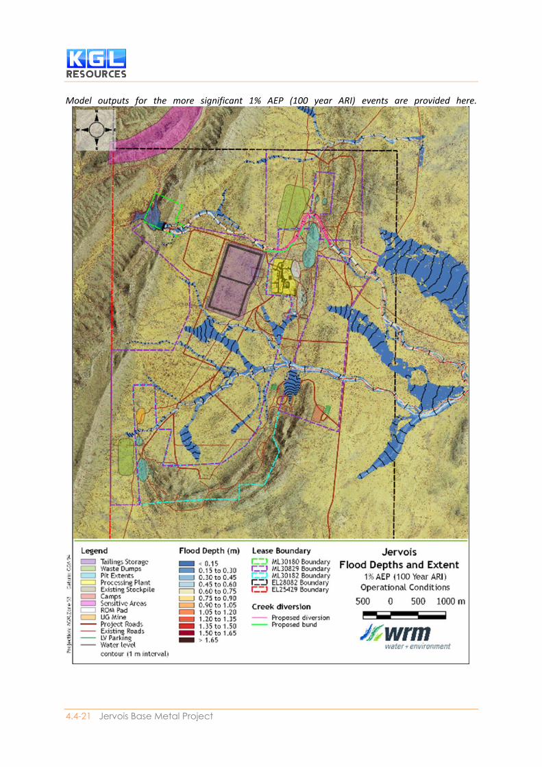
Model outputs for the more significant 1% AEP (100 year ARI) events are provided here.

Impact Assessment
SECTION 4.4| Hydrological Processes 4.4-22
Figure 4.4-3 and Figure 4.4-4 show the peak flood depths and extents in a 1% AEP event, while Figure
4.4-5 and Figure 4.4-6 show the peak velocities in 1% AEP event under existing conditions. Figures
showing 10% AEP (10 year ARI) events are contained in Appendix C5.
The model results indicate that the proposed infrastructure for the Project are generally located
outside of the 1% AEP flood extent except for the proposed Reward Pit, which traverses the Unca
Creek channel and floodplain. The proposed Reward and Bellbird waste rock dumps appear to be
located across existing overland flow paths, however the dumps will not be affected by flooding from
Unca Creek and the Unca Creek tributary. Clean and dirty water diversion drains will be used to
manage overland flows around the waste rock dumps.
The following changes are proposed between the existing conditions and the operational conditions:
• The Jervois Dam spillway will be raised and widened. This will change the behaviour of spills
from the dam and affect design discharges in Unca Creek upstream of the Reward operational
area. The URBS hydrologic model was modified to incorporate the raised dam spillway. The
updated URBS model was then used to derive updated design discharge hydrographs for the
TUFLOW model; and
• The proposed Unca Creek diversion will divert all Unca Creek flows around the proposed
Reward Pit for all evens up to and including the 0.1% AEP event. The TUFLOW hydraulic model
was modified to incorporate this diversion.
Flood impacts of operating mine
The predicted impacts of the Project are summarised below:
• There are no predicted increases in peak flood levels and velocities along the watercourses
traversing the Project area, except in Unca Creek
• The Jervois Dam spillway will be raised and widened under operational conditions, increasing
the peak outflow discharge from the spillway by about 10%, resulting in minor increases in
peak flood levels and velocities along Unca Creek downstream of Jervois Dam
• Increases in peak flood levels of up to 0.1 m are predicted in Unca Creek downstream of
Jervois Dam for the 10% AEP and 1% AEP events. The average increase in flood levels along
Unca Creek is about 0.05 m for the 10% AEP event and about 0.08 m for the 1% AEP event.
These increased flood levels are not expected to have any material impact on existing land
uses downstream of the Project area
• There are minor predicted increases in peak velocities of up to 0.2 m/s in Unca Creek
downstream of Jervois Dam for the 10% AEP and 1% AEP events. The average increase in peak
velocities along Unca Creek is about 0.07 m/s for the 10% AEP event and about 0.11 m/s for
the 1% AEP event. Given that the average peak flood velocities along Unca Creek under
existing conditions are about 0.9 m/s for the 10% AEP event and 1.3 m/s for the 1% AEP event,
the minor predicted increases in peak velocities due to the Project are not considered
significant; and
• If Jervois Dam was removed (the pre-dam case), the 1% AEP peak discharge in Unca Creek
downstream of the dam sit would be approximately 58.4 m3/s. The 1% AEP peak discharge
downstream of the existing dam is 27.6 m3/s, and this will increase to 35.1 m3/s after the dam
is upgraded. Therefore, the predicted increase in flood levels and velocities following the dam
upgrade would be closer to the pre-dam flooding conditions.

4.4-23 Jervois Base Metal Project
Impact of final voids
A water balance model was used to assess the long-term behaviour of the final voids post mine closure.
The final void water balance model (Appendix C5) indicates that:
• All voids will typically have a small volume of surface water runoff stored in the base of the
void
• The stored water depth in each void is predicted to typically vary between 10 m and 15 m
deep, however this may increase to as much as 30 m deep during extended wet periods; and
• The water surfaces in the final voids are generally between 40 m and 100 m below surrounding
ground levels.
Final landform hydraulic modelling indicated that the final voids will be protected from flooding from
Unca Creek and its tributaries for all events up to and including the PMF.
The pits will act as groundwater sinks, i.e. there will be some drawdown associated with them, this
combined with evaporation from the pit lake and pit surfaces, suggests that there will be negligible
groundwater inflows to the final voids. Therefore, the only water that collects in the final voids will
be surface water runoff from the pit catchments. This runoff will collect in the base of the pits and
evaporate over time. The final landform for the Project will ensure that the remnant surface water
catchments that drain into the final voids are limited to the voids themselves.
Therefore, the final voids will have no significant impact on surface water.
Impacts on Water Quality
The Project has the potential to impact on water quality in Unca Creek and its tributaries due to
controlled and uncontrolled releases of water.
The results of the water balance model show that no uncontrolled releases are predicted from the
process water dam in any of the water balance model simulations. Therefore, the Project will not
release any mine affected water or dewatered groundwater to the environment.
The water balance model indicates that there is approximately a 10% chance of uncontrolled releases
of water from the waste rock sediment dams in the first four years of Project life.
The water balance model predicts an increase in uncontrolled releases from the sediment dams
beyond Year 4 of Project life, as groundwater inflows increase and water captured in the sediment
dams is no longer pumped back to the WMS. The water balance model does not consider the potential
for controlled releases of water from the waste rock sediment dam from year 5 onwards (pending
suitable water quality), which would reduce the amount of uncontrolled releases.
It is considered that the predicted uncontrolled releases from the waste rock sediment dam are
unlikely to have any impact of significance on water quality in Unca Creek, as they will occur when
there is likely to be some flow in the receiving watercourses, and the uncontrolled releases are likely
to be of similar quality to background water quality.

Impact Assessment
SECTION 4.4| Hydrological Processes 4.4-24
Changes to streamflow in Unca Creek
The proposed upgrade to Jervois Dam will potentially result in changes to the existing conditions
streamflow regime in Unca Creek. It should be noted that the existing dam has already altered the
streamflow regime of Unca Creek significantly.
The upgraded dam will require a greater volume of catchment runoff to fill the dam before the spillway
is activated and flow leaves the dam. Further, the dam will be relied upon as a source of raw water,
particularly during the first four years of operations (before groundwater inflows to the underground
increase). Therefore, the volume of water stored in the dam will be drawn down after a runoff event
more rapidly than under existing conditions.
Overall, the proposed upgrade to the dam will potentially reduce the magnitude and number of
overflows from the dam, particularly in the first four years of concept mine plan.
The water balance model was used to assess the change in flows in Unca Creek immediately
downstream of the dam following the upgrade. Figure 4.4-9 shows the existing conditions and
predicted post-upgrade (for year 1 of Project life and post-mine closure) flow duration curves for Unca
Creek immediately downstream of the dam for the first four years of Project life.
Figure 4.4-9 Impact of upgraded Jervois Dam on downstream Unca Creek flows
Further, the dam is situated in an arid catchment, where it would not be unusual for the dam not to
overflow for several years. Water balance modelling indicates that the existing dam on average only
overflows in every fourth year. The upgraded dam is predicted to overflow on average every 11 years
under the year 1 scenario, and every 9 years under the post-mine closure scenario.

4.4-25 Jervois Base Metal Project
Figure 4.4-10 Impact of upgraded Jervois Dam on inundation extent at full supply level
Increase in Jervois Dam lake extent
The proposed repairs and upgrade to Jervois Dam (increased spillway level) will result in an increase
in the area inundated by the lake behind the dam wall. Figure 4.4-10 shows the extent of inundation
from the lake at full supply level under both existing conditions and post-mining conditions. The area
of inundation at full supply will increase from about 16 ha under existing conditions to about 36 ha
under the upgraded dam case. The increased inundation extent does not affect any existing structures
or sensitive environmental or cultural heritage areas.

Impact Assessment
SECTION 4.4| Hydrological Processes 4.4-26
The water balance model (Appendix C5) assessed the frequency of inundation. The proposed dam
upgrade will result in an increase to the frequency of inundation; water levels in the upgraded dam
are predicted to exceed the existing full supply level approximately 27% of the time.
Flooding
Modelling of flood events under operational conditions (mine operating) were undertaken for 10%
AEP (10 year ARI) and 1% AEP (100 year ARI) events. The results for the more extreme 1% AEP
events are shown in Figure 4.4-11 and Figure 4.4-12 (flood depths and extents), and Figure 4.4-13,
and Figure 4.4-14 (velocities).
The predicted impacts of the Project are summarised below:
• There are no predicted increases in peak flood levels and velocities along the watercourses
traversing the Project area, except in Unca Creek
• The Jervois Dam spillway will be raised and widened under operational conditions. This has
the effect of increasing the peak outflow discharge from the spillway by about 10%. In turn,
the increased discharges from the dam spillway results in minor increases in peak flood levels
and velocities along Unca Creek downstream of Jervois Dam.
• There are minor predicted increases in peak flood levels of up to 0.1 m in Unca Creek
downstream of Jervois Dam for the 10% AEP and 1% AEP events. The average increase in flood
levels along Unca Creek is about 0.05 m for the 10% AEP event and about 0.08 m for the 1%
AEP event. These minor increases in peak flood levels are not expected to have any material
impact on existing land uses downstream of the Project area
• There are minor predicted increases in peak velocities of up to 0.2 m/s in Unca Creek
downstream of Jervois Dam for the 10% AEP and 1% AEP events. The average increase in peak
velocities along Unca Creek is about 0.07 m/s for the 10% AEP event and about 0.11 m/s for
the 1% AEP event. Given that the average peak flood velocities along Unca Creek under
existing conditions are about 0.9 m/s for the 10% AEP event and 1.3 m/s for the 1% AEP event,
the minor predicted increases in peak velocities due to the Project are not considered
significant; and
• The relatively minor increases in peak flood levels and velocities in Unca Creek due to the
upgrade to Jervois Dam are not considered significant. The increased flood levels and
velocities are typically confined to the Unca Creek channel and do not affect any existing
structures or property. The peak flood levels, discharges and velocities in Unca Creek with the
upgraded dam in place will also be below the ‘pre- dam’ scenario.

4.4-27 Jervois Base Metal Project
Figure 4.4-11 Peak flood depths and extents across the entire Project area, operational conditions,
1% AEP (100 year ARI) event.

4.4-28 Jervois Base Metal Project
Figure 4.4-12 Peak flood depths and extents near the Reward pit and processing plant area,
operational conditions, 1% AEP (100 year ARI) event.

4.4-29 Jervois Base Metal Project
Figure 4.4-13 peak flood velocities across entire Project area, operational conditions, 1% AEP (100
year ARI) event.

4.4-30 Jervois Base Metal Project
Figure 4.4-14 Peak flood velocities near the Reward pit and processing plant, operational
conditions, 1% AEP (100 year ARI) event.

4.4-31 Jervois Base Metal Project
4.4.4.6. Groundwater Numerical groundwater modelling was used to investigate the likely impacts of groundwater
abstraction for the mine process water supply and dewatering of mine excavations on existing users.
Drawdown at Receptors
The closest pastoral bores (RN010717) and the bores near Lucy Creek homestead, which is about 10
km from the planned mine supply borefield. The borefield for Orrtipa-Thurra Community represented
by RN018072 is located about 18 km from the planned mine site.
The results from the drawdown analysis indicate that, for the 10 years scheduled life of mine, a
maximum drawdown of 3 m can be expected at the closest pastoral bores (RN011101, RN011102 &
RN013274), while the bores at Lucy Creek Station (RN013381 and RN018943) show a drawdown of
less than 0.5 m (Figure 4.4-15).
No drawdown is observed at the Orrtipa-Thurra community borefield represented by RN018072.
Following closure of the mine the groundwater levels at the borefield recover to 90% of their pre-
pumping levels in less than 5 years and almost completely recover after 20000d (55 years) (Appedix
C6).
Groundwater modelling (Appendix C6) forecasts that the drawdown impacts around the mine as
shown in Figure 4.4-16. The 0.5 m drawdown at the end of mining extends approximately 1 km beyond
the mining lease to the south of Rockface underground mine.
Life of mine inflows
Inflows to the pits and underground mines have been determined during the life of mine (Appendix
C6). Inflows into pits increase from commencement of mining and reach a peak during year 3 at about
0.2 ML/d (1.8 L/s). Inflows to the underground mines increase from commencement of mining and
reach a peak during year 7 at about 6.3 ML/d (74 L/s).
Contamination from TSF
The mine operation tailings will be stored in a tailings storage facility (TSF) to the west of Reward pit.
Without proper control some tailings liquor will seep from storage in the TSF to the groundwater table.
This may result in some increase in groundwater level and change to the chemical composition of
groundwater. Random walk particle tracking indicates that in the long-term the particles sourced
from the areas beneath the TSF will be captured by the formation of a pit-lake at Reward pit.
Groundwater Dependant Ecosystems
There are no identified groundwater dependant ecosystems (GDE’s) within at least 40 kilometres of
the process water supply borefield and the depth to groundwater generally precludes ecosystem use.
A single waterhole is mapped to the southeast of the mine site, although generally groundwater levels
in the mine site are generally greater than 20 metres below ground level suggesting that this feature
is likely to be disconnected from the regional groundwater system. Two sites show groundwater levels
less than 5 m below ground level and are associated with Unca Creek.

Impact Assessment
SECTION 4.4| Hydrological Processes 4.4-32
There is no evidence of stygofauna at the Project site (although there presence is possible). The impact
on potential stygofauna for this Project is dewatering of the aquifer habitat in proximity to the
borefield. Any potential impact must be assessed in the context of habitat reduction, however, as the
mine water supply will result in a water table drawdown of less than 10 m (total aquifer thickness in
basin over 100 m) over a small area relative to the total Georgina Basin extent, although possible the
impact would be minimal. Therefore, the risk of impact to stygofauna from groundwater drawdown
is low.
Figure 4.4-15 Modelled drawdown after 10 years of groundwater abstraction from the process
water supply borefield

4.4-33 Jervois Base Metal Project
Figure 4.4-16 Life of mine final drawdown contours after 10 years of mining
4.4.5. Mitigation and monitoring
4.4.5.1. Mitigation The mitigation measures put in place to safeguard surface and groundwater resources and their
environmental values, to ensure the protection and resilience of water dependent ecosystems
include:
• Water management systems to keep different types of water separate
• Controlled waste stockpiling (waste rock and tailings)
• Sediment dams to capture sediment and reduce turbidity
Impact Assessment
SECTION 4.4| Hydrological Processes 4.4-34
• Standard storage and handling protocols (bunded storage, spill kits etc) for processing
reagents and hydrocarbons will be implemented
• Construction of low bunds at the crest of each batter to assist with surface water control
on batters
• Deep ripping on the contour to assist with water management and minimisation of
erosion
• Shaping the upper surface to most appropriately mange surface water; and
• Deep ripping on the contour to assist with water adsorption and surface water control.
Water Management
The Water Management Plan (refer Section 5) provides control strategies, including a description of
the surface water drainage arrangements, water management system and water balance and a
discussion of options and alternatives for meeting the proposed water management objectives.
Based on the ANZECC & ARMCANZ (2000) guideline, the condition of the watercourses in the vicinity
of the Project is considered as Condition 2: slightly to moderately disturbed ecosystem. The ANZECC
& ARMCANZ (2000) water quality objectives (WQO) for aquatic ecosystems are considered to be the
most appropriate. Where no aquatic ecosystem WQO value is available for a certain parameter, a
WQO has been sourced from alternative EVs e.g. WQOs for pH, electrical conductivity (EC), turbidity,
dissolved oxygen (DO), sulphate and iron were sourced from ANZECC & ARMCANZ (2000) guidelines
for either livestock drinking water or recreation.
Although the water balance model suggests that managed releases will not be required from the Project, a WDL will be required to ensure flexibility for water management at the Project and to define the requirements for monitoring at the site to ensure relevant EVs are protected. A WDL will be acquired for the Project. Under a WDL, managed releases from an authorised discharge point are permitted only when the managed release will not contribute to the exceedance of water quality trigger levels specified in the WDL.
The key objectives of the Project’s water management system are:
• To protect environmental values of the receiving waters downstream of the Project during the operational period and post-closure; and
• To ensure that the Project has sufficient water available for operations during dry times.
To achieve the water management objectives and strategies, mine water is managed based on quality using the mine water quality classification system (refer section 4.4.4):
• Undisturbed Areas
• Water Storage Surfaces
• Runoff from ROM and product stockpiles (mine affected water)
• Runoff from processing plant area (mine affected water)
• Runoff from pit areas (mine affected water); and
• Waste rock dumps (sediment laden water).
The adopted principles for management of water on the site are summarised as follows:
• Existing surface water drainage patterns will be maintained where practical to do so

4.4-35 Jervois Base Metal Project
• Water from different sources will be managed separately o Undisturbed runoff will be diverted around disturbed areas where practical o Mine affected water collected in-open cut pits, and in the process water dam will be
managed using temporary in-pit sumps and re-used within the water management system o Sediment-laden runoff from the proposed waste rock dumps will be captured in dedicated
sediment dams and re-used within the water management system o Raw water (plant standard) dewatered from the open cut pits and underground mines will
be reused within the water management system
• Water will be selected for use based on water quality considerations; and
• Water collected on site as part of mining operations will be used preferentially in order to reduce demand on external water sources. Water for mine operating purposes (excluding supplying potable water) will be sourced preferentially as follows: o Mine affected water o Sediment laden water o Raw water (plant standard), dewatered from the underground mines o Raw water (potable standard), sourced from Jervois Dam; and o Raw water (potable standard) sourced from the external borefield.
The proposed water management system (WMS) schematic for the Project is shown in Figure 4.4-17.
The WMS layout for the Reward operations is shown in Figure 4.4-18 and Figure 4.4-19Error!
Reference source not found. for the Bellbird operations.

4.4-36 Jervois Base Metal Project
Figure 4.4-17 Water management system (WMS) schematic

4.4-37 Jervois Base Metal Project
Figure 4.4-18 Proposed water management system (WMS) layout for the Reward mining operations

4.4-38 Jervois Base Metal Project
Figure 4.4-19 Proposed water management system (WMS) layout for the Bellbird and Rockface mining operations

4.4-39 Jervois Base Metal Project
Changes to streamflow in Unca Creek
There are three proposed bunds along the Unca Creek Diversion are required to prevent water
overflowing from the diversion channel into the existing creek channels (and then into the Reward
pit). The most upstream bund will double as the embankment wall for the Process Water Dam.
Excessive velocities are not predicted in the Unca Creek diversion channel, and therefore excessive
erosion (beyond what naturally occurs in streams at the Project) is unlikely to occur. Nevertheless, the
diversion channel will be inspected following flow events to identify any locations where erosion is
occurring and identify remediation works.
The proposed upgrade to the dam will potentially reduce the magnitude and number of overflows
from the dam, particularly in the first four years of the concept mine plan. However, the existing dam
has already altered the streamflow regime of Unca Creek significantly and the dam is situated in an
arid catchment where it would not be unusual for the dam not to overflow for several years. While
the changed streamflow within the Project area will be significant, downstream of the Project they
will be insignificant and therefore no specific mitigation measures are proposed. Consideration will
be given to lowering the spillway at the end of the concept mine plan.
Increase in Jervois Dam Lake Extent
The spillway level will ensure that the sacred site located upstream of the dam will not be inundated
by standing water. However, the mine closure plan for Jervois Dam could include the upgraded dam
remaining in place, reduction in spillway level to the pre-mining level, or complete removal of the dam,
depending on whether maintaining the dam is beneficial to the post-mining landholder.
Waste Dumps
The material placed in the waste rock dumps and the proposed dump construction methods will
ensure that runoff from the dumps is generally of similar quality to background runoff from
undisturbed catchments within the Project site, and will not be contain acid rock drainage or
significantly elevated concentrations of metalloids (beyond background values).
Final voids
The proposed final landform ensures that the only water that collects in the final voids will be surface
water runoff from the pit catchments.
The final landform also provides the final voids with immunity from flooding for events up to and
including the Probable Maximum Flood (PMF) event.
Water Quality
Controlled releases of water will only take place from the waste rock dump sediment dams after year
4 of Project life, provided the quality of runoff from the waste rock dumps has been proven to be
equal to or better than background water quality in undisturbed drainage features within the Project
area, or agreed WQOs. No controlled releases of water to the receiving environment are proposed
from the process water dam.

Impact Assessment
SECTION 4.4| Hydrological Processes 4.4-40
Flooding
The Project will not have any significant impact on flooding downstream.
The Jervois Dam repair and Unca Creek diversion and bunds are proposed to mitigate the potential
impact of flooding on planned mine infrastructure.
Post-mining the height of the Unca Creek diversion and Process Water Dam bunds would be increased
to ensure that the Reward Pit final void is protected from floodwater for the Probable Maximum Flood
(PMF) event.
Emergency and contingency plan
Emergency responses to specific incidents will be carried out as per the Emergency Response Plan and
Crisis Management Manual for the mine. With respect to water management, the Emergency
Response Plan is implemented for a range of potential emergency scenarios:
• Exceedance of design rainfall events
• Failure of containment structures
• Loss of electrical supply; and
• Supply of critical equipment and spare parts.
Water storages at the mine will be operated in accordance with the Trigger Action Response Plan
(TARP) for each structure.
4.4.5.2. Monitoring Monitoring of surface water and groundwater quality will be ongoing as part of the Project, both for
background water quality locations (undisturbed by mining), the surface water storages proposed as
part of the Project, the bore field and onsite monitoring bores, as well as in receiving environments
downstream of the Project area.
The Water Management Plan (refer Section 5) details a description of the water management and
monitoring measures to address each of the Project impacts and maintain the effective operation of
the control strategies.
Background and receiving water monitoring will continue to take place following runoff events at the
monitoring locations shown on Figure 4.4-20. The proposed storages at the Project (process water
dam, Jervois Dam, underground dewatering dam and waste rock sediment dams) will be monitored
at least quarterly (and daily during or following significant runoff events). The proposed suite of
monitoring parameters and recommended monitoring frequency is given in Table 4.4-4 Proposed
surface water storage monitoring parameters and frequenciesTable 4.4-4.

4.4-41 Jervois Base Metal Project
Table 4.4-4 Proposed surface water storage monitoring parameters and frequencies
Parameter Frequency
Water level / storage volume Daily
Non-metallic indicators
pH Quarterly / during significant runoff events
Electrical conductivity Quarterly / during significant runoff events
Total dissolved solids Quarterly / during significant runoff events
Turbidity Quarterly / during significant runoff events
Dissolved oxygen Quarterly / during significant runoff events
Sulphate Quarterly / during significant runoff events
Nitrate Quarterly / during significant runoff events
Metals and metalloids (filtered, unless otherwise stated)
Aluminium Quarterly / during significant runoff events
Arsenic Quarterly / during significant runoff events
Cadmium Quarterly / during significant runoff events
Copper Quarterly / during significant runoff events
Iron Quarterly / during significant runoff events
Lead Quarterly / during significant runoff events
Magnesium Quarterly / during significant runoff events
Manganese Quarterly / during significant runoff events
Mercury Quarterly / during significant runoff events
Nickel Quarterly / during significant runoff events
Zinc Quarterly / during significant runoff events
4.4.6. Conclusion The assessments undertaken demonstrate that with appropriate water management and mitigation
measures in place, the potential impact of the Project on groundwater, surface flows and water quality
in the receiving waters downstream of the Jervois Mine will be acceptable.
The Project is able to meet the NT EPA’s objective related to surface water and groundwater to:
“maintain the hydrological regimes of groundwater and surface water so that environmental values
are protected both now and in the future”.

4.4-42 Jervois Base Metal Project
Figure 4.4-20 Locations for surface water monitoring program