section 7 access roads and driveway runoff - … · hill and downhill to facilitate travel and ......
TRANSCRIPT

Coeur d’Alene Lake Management Plan - Lake*A*Syst Manual: IDEQ (208) 769-1422 and the CDA Tribe (208) 667-5772
SECTION 7 ACCESS ROADS AND DRIVEWAY RUNOFF
Why are Roads an Issue? Most private roads and driveways are constructed of compacted native soils. These dirt roads, if not properly managed, can become damaged by erosion after just a single storm. If a road is designed without runoff control practices, water runs freely downhill, picking up speed, and scouring away the road. This runoff creates huge ruts, gullies, washouts, and flood-ing. As stormwater runoff speeds its way downhill, it picks up tons of soil (sediment) and other pollu-tants from the road. Eventually, this polluted water finds its way into streams, rivers, and lakes. The pol-luted water can be detrimental to water quality by covering fish spawning beds, creating muddy waters, adding excess nutrients, and causing algae blooms and aquatic plant growth. Road erosion can also be costly to landowners, both in repair and property val-ue. Quality Construction - The Bottom Line High-quality road design by engineers and heavy equipment operators is invaluable for the safety and longevity of roads and driveways, as well as the pro-tection of our natural resources. Unfortunately, many private roads are constructed by an operator who has insufficient knowledge and experience in this area. As a result, ruts, gullies, washouts, and flooding be-come expensive and dangerous problems. Water runoff can be slowed by numerous control measures and diverted into vegetated drainage areas, where the dirt it carries is captured, and the water is filtered back into the ground. These drainage control methods may include open-top box culverts, water bars, road sloping, and rolling dips. Constructing your road properly is an excellent long-term invest-ment.
Public Access Versus Private Residential Roads Many roads around the state were once used as log-ging roads. They were often constructed without much consideration to alignment or grade, due to their short-term use and controlled access. Unfortu-nately, these same roads are now used for continuous residential access without changing the grading and drainage (Figure 7-1). Today this discrepancy is the cause of increased erosion and is often a source of sedimentation into surface water. Maintenance of our public roads depends on who owns the property and the activities taking place, such as a timber sale. Maintenance may involve the U.S. Forest Service, Idaho Department of Lands (IDL), local highway district, or county or city road departments. Unfortunately, because there are so many public access roads, maintenance can be left unattended. If you observe a hazardous road, report it to one of these agencies. Homeowners, however, are responsible for private driveways and roads. Op-portunities for design improvements on existing roads often exist. Each road and site is unique and should be evaluated on the ground by a private engi-neer or other professionals from agencies like the Natural Resources Conservation Service (NRCS) or IDL. The following guidelines are designed to pro-vide property owners with a basic understanding of access road and driveway maintenance.
This fact sheet addresses the impacts improper road construction and maintenance can have on water quality and how you can make a difference with Best Management Practices (BMPs). BMPs are actions you can take to protect our natural resources. The ultimate goal of this information is to provide general guidelines on proper road construction and maintenance for private roads to avoid negative impacts to water quality.
1. Read the facts and information in the following pages. 2. Fill out the risk assessment worksheet (p. 7-13) in order to analyze your property's specific needs. 3. Fill out the action worksheet (p. 7-14), then take action!
7-1
Figure 7-1. Improper grading and drainage creates ruts and gullies in roads, increasing erosion and sedimentation.
Coeur d’Alene Lake Management Plan - Lake*A*Syst Manual: IDEQ (208) 769-1422 and the CDA Tribe (208) 667-5772
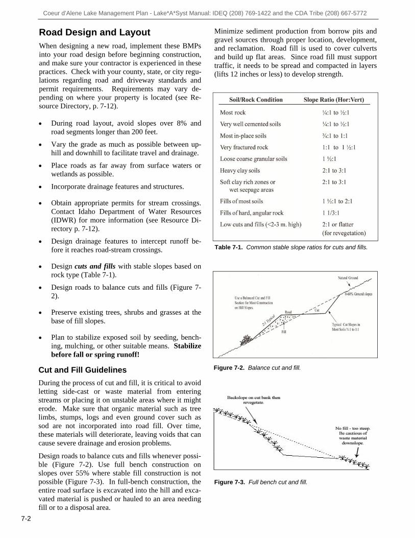
Road Design and Layout When designing a new road, implement these BMPs into your road design before beginning construction, and make sure your contractor is experienced in these practices. Check with your county, state, or city regu-lations regarding road and driveway standards and permit requirements. Requirements may vary de-pending on where your property is located (see Re-source Directory, p. 7-12). During road layout, avoid slopes over 8% and road segments longer than 200 feet. Vary the grade as much as possible between up-
hill and downhill to facilitate travel and drainage. Place roads as far away from surface waters or
wetlands as possible. Incorporate drainage features and structures. Obtain appropriate permits for stream crossings.
Contact Idaho Department of Water Resources (IDWR) for more information (see Resource Di-rectory p. 7-12).
Design drainage features to intercept runoff be-
fore it reaches road-stream crossings. Design cuts and fills with stable slopes based on
rock type (Table 7-1). Design roads to balance cuts and fills (Figure 7-
2). Preserve existing trees, shrubs and grasses at the
base of fill slopes. Plan to stabilize exposed soil by seeding, bench-
ing, mulching, or other suitable means. Stabilize before fall or spring runoff!
Cut and Fill Guidelines
During the process of cut and fill, it is critical to avoid letting side-cast or waste material from entering streams or placing it on unstable areas where it might erode. Make sure that organic material such as tree limbs, stumps, logs and even ground cover such as sod are not incorporated into road fill. Over time, these materials will deteriorate, leaving voids that can cause severe drainage and erosion problems. Design roads to balance cuts and fills whenever possi-ble (Figure 7-2). Use full bench construction on slopes over 55% where stable fill construction is not possible (Figure 7-3). In full-bench construction, the entire road surface is excavated into the hill and exca-vated material is pushed or hauled to an area needing fill or to a disposal area.
Table 7-1. Common stable slope ratios for cuts and fills.
Figure 7-2. Balance cut and fill.
Figure 7-3. Full bench cut and fill.
Minimize sediment production from borrow pits and gravel sources through proper location, development, and reclamation. Road fill is used to cover culverts and build up flat areas. Since road fill must support traffic, it needs to be spread and compacted in layers (lifts 12 inches or less) to develop strength.
7-2

Coeur d’Alene Lake Management Plan - Lake*A*Syst Manual: IDEQ (208) 769-1422 and the CDA Tribe (208) 667-5772
7-3
During Construction The following BMPs are used to control erosion dur-ing and after the construction process. Make sure your contractor and you are familiar with these prac-tices (Figure 7-4).
Construct roads in a manner that prevents sediment, debris, and excess materials from entering streams. Deposit excess materials outside of stream protection zones (see Section 8, Riparian, Forest and Pasture Management, for more information on stream protec-tion zones).
Clear drainage ways of all debris generated dur-
ing construction. Construct drainage features to intercept runoff
before it reaches road-stream crossings. Protect trees and shrubs growing at the base of
fill slopes. When constructing road fills near streams, com-
pact the material in lifts less than 1 foot high. Reduce water flowing over fill. Prevent snow, ice, frozen soil, and woody debris from being buried in the fill. Limited slash and debris may be windrowed along the toe of the fill to provide a filter near stream crossings.
Cover all bare soil with mulch, seed, or rock
(Figure 7-5). For more information on erosion control, see Section 6, New Construction.
Construct the road with shallow, outward-sloping
dips to collect surface runoff and convey it away from the road surface (Figure 7-6).
During construction and maintenance, do not cre-
ate a gravel or snow berm on the outside shoul-der. This berm will eliminate all opportunities for runoff on the road surface to escape.
Permanently mark road culverts to aid in location.
If not correctly marked, snow plows are likely to crush culverts (Figure 7-7).
Figure 7-7. Crushed culvert cross drain.
Figure 7-6. Road constructed with outward sloping rolling dips.
Figure 7-4. Poor placement of erosion control BMPs may result in sediments entering streams.
Figure 7-5. Exposed soil has been mulched.
Coeur d’Alene Lake Management Plan - Lake*A*Syst Manual: IDEQ (208) 769-1422 and the CDA Tribe (208) 667-5772
Road Grade (percent)
Spacing Between Open-Top Culverts and Rolling Dips (feet)
2 to 5 6 to 10
11 to 15 16 to 20
>20
300 to 500 200 to 300 100 to 200
<100 Consider seasonal traffic restrictions
Drainage Improvement Methods Road location, construction, and drainage can cause negative impacts to water quality, cause erosion, and increase road costs. Drainage issues include roadway surface drainage, ditch water, culvert design, and nat-ural stream crossings. The BMPs below, provided by numerous agencies and professionals, do not substi-tute for a technical guide. Contact a design profes-sional for more information (see Resource Directory, p. 7-12).
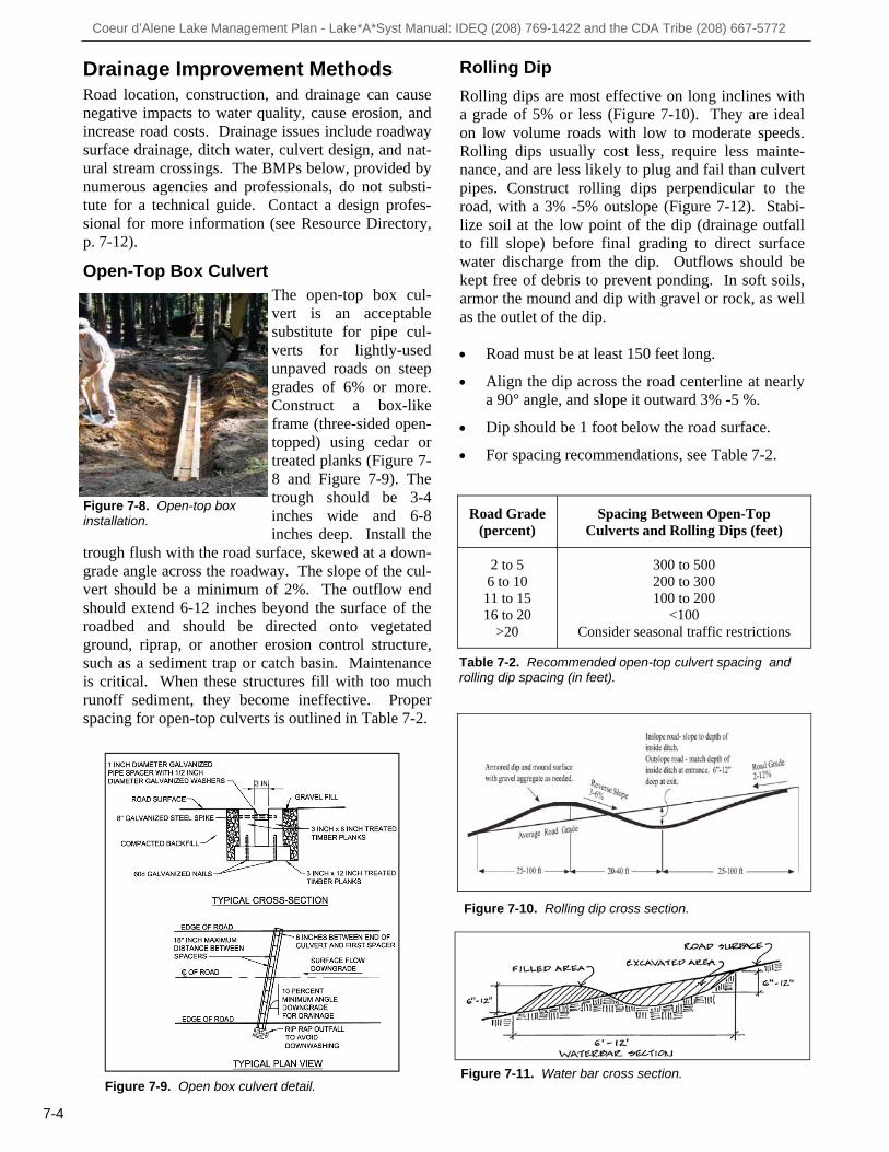
Open-Top Box Culvert The open-top box cul-vert is an acceptable substitute for pipe cul-verts for lightly-used unpaved roads on steep grades of 6% or more. Construct a box-like frame (three-sided open-topped) using cedar or treated planks (Figure 7-8 and Figure 7-9). The trough should be 3-4 inches wide and 6-8 inches deep. Install the
trough flush with the road surface, skewed at a down-grade angle across the roadway. The slope of the cul-vert should be a minimum of 2%. The outflow end should extend 6-12 inches beyond the surface of the roadbed and should be directed onto vegetated ground, riprap, or another erosion control structure, such as a sediment trap or catch basin. Maintenance is critical. When these structures fill with too much runoff sediment, they become ineffective. Proper spacing for open-top culverts is outlined in Table 7-2.
7-4
Figure 7-9. Open box culvert detail.
Table 7-2. Recommended open-top culvert spacing and rolling dip spacing (in feet).
Figure 7-8. Open-top box installation.
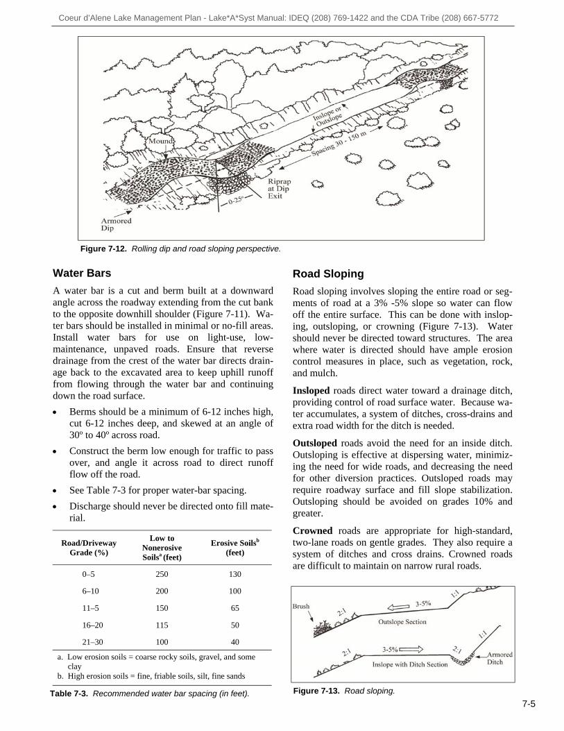
Rolling Dip Rolling dips are most effective on long inclines with a grade of 5% or less (Figure 7-10). They are ideal on low volume roads with low to moderate speeds. Rolling dips usually cost less, require less mainte-nance, and are less likely to plug and fail than culvert pipes. Construct rolling dips perpendicular to the road, with a 3% -5% outslope (Figure 7-12). Stabi-lize soil at the low point of the dip (drainage outfall to fill slope) before final grading to direct surface water discharge from the dip. Outflows should be kept free of debris to prevent ponding. In soft soils, armor the mound and dip with gravel or rock, as well as the outlet of the dip. Road must be at least 150 feet long. Align the dip across the road centerline at nearly
a 90° angle, and slope it outward 3% -5 %. Dip should be 1 foot below the road surface. For spacing recommendations, see Table 7-2.
Figure 7-10. Rolling dip cross section.
Figure 7-11. Water bar cross section.
Coeur d’Alene Lake Management Plan - Lake*A*Syst Manual: IDEQ (208) 769-1422 and the CDA Tribe (208) 667-5772
Water Bars
A water bar is a cut and berm built at a downward angle across the roadway extending from the cut bank to the opposite downhill shoulder (Figure 7-11). Wa-ter bars should be installed in minimal or no-fill areas. Install water bars for use on light-use, low-maintenance, unpaved roads. Ensure that reverse drainage from the crest of the water bar directs drain-age back to the excavated area to keep uphill runoff from flowing through the water bar and continuing down the road surface.
Berms should be a minimum of 6-12 inches high, cut 6-12 inches deep, and skewed at an angle of 30º to 40º across road.
Construct the berm low enough for traffic to pass over, and angle it across road to direct runoff flow off the road.
See Table 7-3 for proper water-bar spacing.
Discharge should never be directed onto fill mate-rial.
7-5
Road Sloping
Road sloping involves sloping the entire road or seg-ments of road at a 3% -5% slope so water can flow off the entire surface. This can be done with inslop-ing, outsloping, or crowning (Figure 7-13). Water should never be directed toward structures. The area where water is directed should have ample erosion control measures in place, such as vegetation, rock, and mulch. Insloped roads direct water toward a drainage ditch, providing control of road surface water. Because wa-ter accumulates, a system of ditches, cross-drains and extra road width for the ditch is needed. Outsloped roads avoid the need for an inside ditch. Outsloping is effective at dispersing water, minimiz-ing the need for wide roads, and decreasing the need for other diversion practices. Outsloped roads may require roadway surface and fill slope stabilization. Outsloping should be avoided on grades 10% and greater. Crowned roads are appropriate for high-standard, two-lane roads on gentle grades. They also require a system of ditches and cross drains. Crowned roads are difficult to maintain on narrow rural roads.
Figure 7-12. Rolling dip and road sloping perspective.
Table 7-3. Recommended water bar spacing (in feet). Figure 7-13. Road sloping.
Road/Driveway Grade (%)
Low to Nonerosive Soilsa (feet)
Erosive Soilsb
(feet)
0–5 250 130
6–10 200 100
11–5 150 65
16–20 115 50
21–30 100 40
a. Low erosion soils = coarse rocky soils, gravel, and some clay b. High erosion soils = fine, friable soils, silt, fine sands
Coeur d’Alene Lake Management Plan - Lake*A*Syst Manual: IDEQ (208) 769-1422 and the CDA Tribe (208) 667-5772
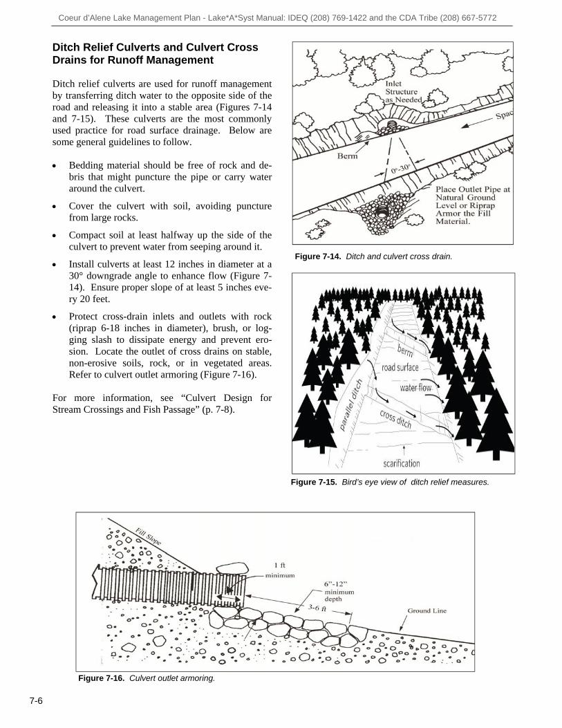
Figure 7-14. Ditch and culvert cross drain.
Ditch Relief Culverts and Culvert Cross Drains for Runoff Management Ditch relief culverts are used for runoff management by transferring ditch water to the opposite side of the road and releasing it into a stable area (Figures 7-14 and 7-15). These culverts are the most commonly used practice for road surface drainage. Below are some general guidelines to follow. Bedding material should be free of rock and de-
bris that might puncture the pipe or carry water around the culvert.
Cover the culvert with soil, avoiding puncture
from large rocks. Compact soil at least halfway up the side of the
culvert to prevent water from seeping around it. Install culverts at least 12 inches in diameter at a
30° downgrade angle to enhance flow (Figure 7-14). Ensure proper slope of at least 5 inches eve-ry 20 feet.
Protect cross-drain inlets and outlets with rock
(riprap 6-18 inches in diameter), brush, or log-ging slash to dissipate energy and prevent ero-sion. Locate the outlet of cross drains on stable, non-erosive soils, rock, or in vegetated areas. Refer to culvert outlet armoring (Figure 7-16).
For more information, see “Culvert Design for Stream Crossings and Fish Passage” (p. 7-8).
7-6
Figure 7-16. Culvert outlet armoring.
Figure 7-15. Bird’s eye view of ditch relief measures.
Coeur d’Alene Lake Management Plan - Lake*A*Syst Manual: IDEQ (208) 769-1422 and the CDA Tribe (208) 667-5772
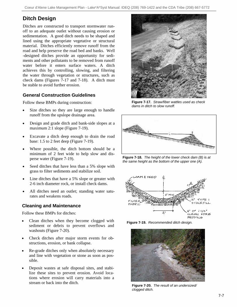
Ditch Design Ditches are constructed to transport stormwater run-off to an adequate outlet without causing erosion or sedimentation. A good ditch needs to be shaped and lined using the appropriate vegetative or structural material. Ditches efficiently remove runoff from the road and help preserve the road bed and banks. Well-designed ditches provide an opportunity for sedi-ments and other pollutants to be removed from runoff water before it enters surface waters. A ditch achieves this by controlling, slowing, and filtering the water through vegetation or structures, such as check dams (Figures 7-17 and 7-18). A ditch must be stable to avoid further erosion. General Construction Guidelines
Follow these BMPs during construction:
Size ditches so they are large enough to handle runoff from the upslope drainage area.
Design and grade ditch and bank-side slopes at a maximum 2:1 slope (Figure 7-19).
Excavate a ditch deep enough to drain the road base: 1.5 to 2 feet deep (Figure 7-19).
Where possible, the ditch bottom should be a minimum of 2 feet wide to help slow and dis-perse water (Figure 7-19).
Seed ditches that have less than a 5% slope with grass to filter sediments and stabilize soil.
Line ditches that have a 5% slope or greater with 2-6 inch diameter rock, or install check dams.
All ditches need an outlet; standing water satu-rates and weakens roads.
7-7
Figure 7-19. Recommended ditch design.
Cleaning and Maintenance
Follow these BMPs for ditches:
Clean ditches when they become clogged with sediment or debris to prevent overflows and washouts (Figure 7-20).
Check ditches after major storm events for ob-structions, erosion, or bank collapse.
Re-grade ditches only when absolutely necessary and line with vegetation or stone as soon as pos-sible.
Deposit wastes at safe disposal sites, and stabi-lize these sites to prevent erosion. Avoid loca-tions where erosion will carry materials into a stream or back into the ditch.
Figure 7-17. Straw/fiber wattles used as check dams in ditch to slow runoff.
Figure 7-18. The height of the lower check dam (B) is at the same height as the bottom of the upper one (A).
Figure 7-20. The result of an undersized/clogged ditch.
Coeur d’Alene Lake Management Plan - Lake*A*Syst Manual: IDEQ (208) 769-1422 and the CDA Tribe (208) 667-5772
7-8
General Culvert Installation Guidelines
Follow these guidelines for culvert installations: Divert all existing or potential stream flows
while the culvert is being installed. This diver-sion will reduce or avoid sedimentation below the installation site.
Minimize equipment use in the stream bed. Complete downstream work first, such as energy
-dissipating devices and large rock riprap. Place culvert inlets on the same level as the
stream bottom or slightly below. Cover the top of culverts with fill to a depth of
1/3 the pipe diameter or at least 12 inches, whichever is greater, to prevent crushing (Figure 7-22).
Compact and armor backfill material at the inlet
to prevent water from seeping around culvert. Culvert should extend at least 1 foot past fill ma-
terial and be level with the stream bottom.
Figure 7-22. General installation guidelines for culverts at stream crossings.
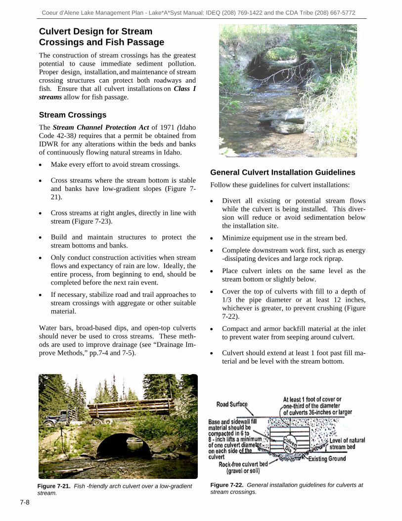
Culvert Design for Stream Crossings and Fish Passage The construction of stream crossings has the greatest potential to cause immediate sediment pollution. Proper design, installation, and maintenance of stream crossing structures can protect both roadways and fish. Ensure that all culvert installations on Class I streams allow for fish passage. Stream Crossings
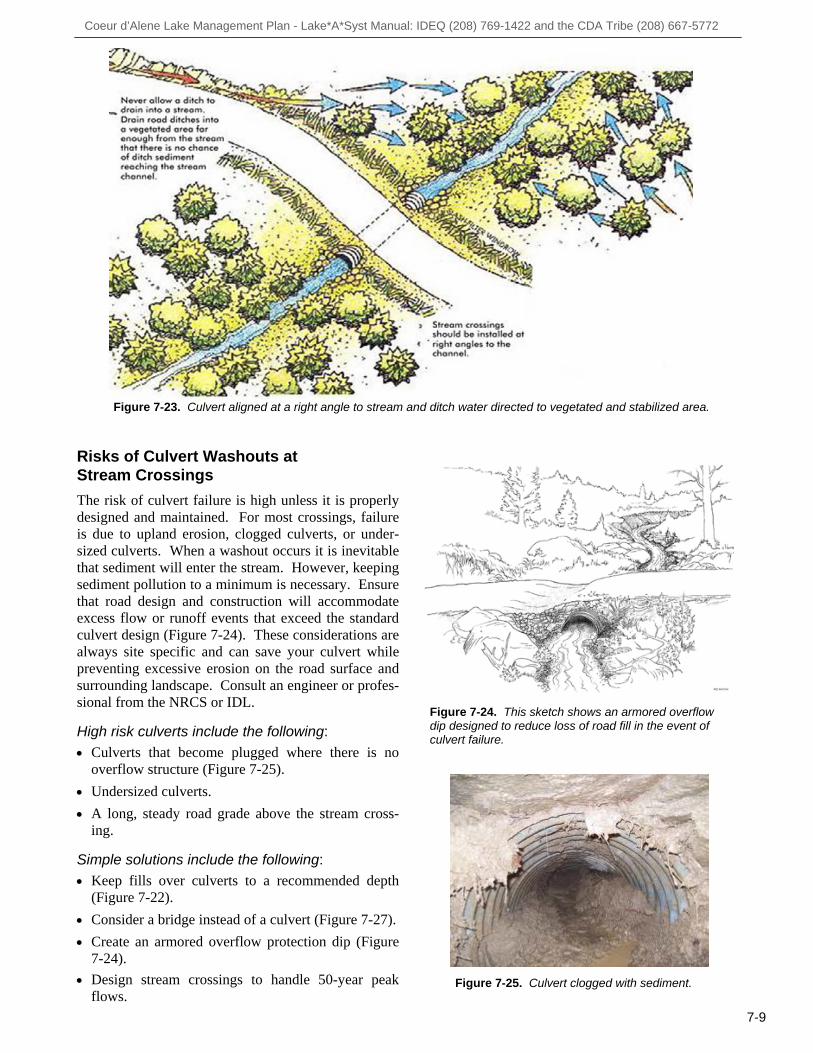
The Stream Channel Protection Act of 1971 (Idaho Code 42-38) requires that a permit be obtained from IDWR for any alterations within the beds and banks of continuously flowing natural streams in Idaho. Make every effort to avoid stream crossings. Cross streams where the stream bottom is stable
and banks have low-gradient slopes (Figure 7-21).
Cross streams at right angles, directly in line with
stream (Figure 7-23). Build and maintain structures to protect the
stream bottoms and banks. Only conduct construction activities when stream
flows and expectancy of rain are low. Ideally, the entire process, from beginning to end, should be completed before the next rain event.
If necessary, stabilize road and trail approaches to
stream crossings with aggregate or other suitable material.
Water bars, broad-based dips, and open-top culverts should never be used to cross streams. These meth-ods are used to improve drainage (see “Drainage Im-prove Methods,” pp.7-4 and 7-5).
Figure 7-21. Fish -friendly arch culvert over a low-gradient stream.
Coeur d’Alene Lake Management Plan - Lake*A*Syst Manual: IDEQ (208) 769-1422 and the CDA Tribe (208) 667-5772
Risks of Culvert Washouts at Stream Crossings
The risk of culvert failure is high unless it is properly designed and maintained. For most crossings, failure is due to upland erosion, clogged culverts, or under-sized culverts. When a washout occurs it is inevitable that sediment will enter the stream. However, keeping sediment pollution to a minimum is necessary. Ensure that road design and construction will accommodate excess flow or runoff events that exceed the standard culvert design (Figure 7-24). These considerations are always site specific and can save your culvert while preventing excessive erosion on the road surface and surrounding landscape. Consult an engineer or profes-sional from the NRCS or IDL. High risk culverts include the following: Culverts that become plugged where there is no
overflow structure (Figure 7-25). Undersized culverts. A long, steady road grade above the stream cross-
ing. Simple solutions include the following: Keep fills over culverts to a recommended depth
(Figure 7-22). Consider a bridge instead of a culvert (Figure 7-27). Create an armored overflow protection dip (Figure
7-24). Design stream crossings to handle 50-year peak
flows.
Figure 7-23. Culvert aligned at a right angle to stream and ditch water directed to vegetated and stabilized area.
7-9
Figure 7-25. Culvert clogged with sediment.
Figure 7-24. This sketch shows an armored overflow dip designed to reduce loss of road fill in the event of culvert failure.

Coeur d’Alene Lake Management Plan - Lake*A*Syst Manual: IDEQ (208) 769-1422 and the CDA Tribe (208) 667-5772
Culvert Design Recommendations
Use bridges, bottomless arches, or partially buried culverts in areas where fish passage is an im-portant consideration (Figures 7-26 and 7-27).
Make sure there is no sudden increase or decrease
in gradient (Figure 7-28). Place culverts on natu-ral stream bed grade or slightly below.
Design culverts so that water velocities passing
through the pipe are equal to water velocities in the stream.
Cross streams are right angles, directly in line
with stream (Figure 7-23). Provide resting pools at culvert inlets and outlets
on streams with high gradients. Fish need a place to rest before they make the journey through a culvert.
Place riprap securely at culvert inlet to prevent
loose material around inlet from clogging the cul-vert.
Fish-Friendly Culverts Fish-friendly culverts at stream crossings are essen-tial where trout and other species move upstream and downstream to spawn and meet habitat needs. The information provided in this section is not meant as a technical guide. See Resource Directo-ry, p. 7-12, for local natural resource and design professionals.
Culverts can impede fish passage when: Water velocities are too powerful for fish to
move through. Vertical barriers are too high for fish. Inadequate water depth prevents fish from being
adequately submerged. Ice and debris caught in culvert prevent passage
or trap fish inside. Overall culvert design does not accommodate
the size and species of fish present in stream.
Figure 7-28. This culvert is too high. It creates a vertical barrier for fish and scours the outlet.
Figure 7-27. Arch culvert as alternative to whole pipe.
7-10
Courtesy of Oregon Watershed Assessment Manual
Figure 7-26. A bridge is an alternative to a culvert.
Coeur d’Alene Lake Management Plan - Lake*A*Syst Manual: IDEQ (208) 769-1422 and the CDA Tribe (208) 667-5772
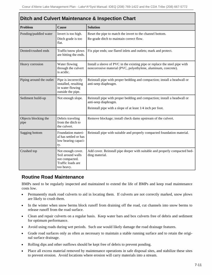
Ditch and Culvert Maintenance & Inspection Chart
Problem Cause Solution
Ponding/puddled water Invert is too high. Ditch grade is too flat.
Reset the pipe to match the invert to the channel bottom. Re-grade ditch to maintain correct flow.
Dented/crushed ends
Traffic/snow plows are hitting the ends.
Fix pipe ends; use flared inlets and outlets; mark and protect.
Heavy corrosion Water flowing through the culvert is acidic.
Install a sleeve of PVC in the existing pipe or replace the steel pipe with noncorrosive material (PVC, polyethylene, aluminum, concrete).
Piping around the outlet Pipe is incorrectly installed, resulting in water flowing outside the pipe.
Reinstall pipe with proper bedding and compaction; install a headwall or anti-seep diaphragm.
Sediment build-up Not enough slope. Reinstall pipe with proper bedding and compaction; install a headwall or anti-seep diaphragm. Reinstall pipe with a slope of at least 1/4 inch per foot.
Objects blocking the pipe
Debris traveling from the ditch to the culvert.
Remove blockage; install check dams upstream of the culvert.
Sagging bottom Foundation materi-al has settled or has low bearing capaci-ty.
Reinstall pipe with suitable and properly compacted foundation material.
Crushed top Not enough cover. Soil around walls not compacted. Traffic loads are too heavy.
Add cover. Reinstall pipe deeper with suitable and properly compacted bed-ding material.
7-11
Routine Road Maintenance BMPs need to be regularly inspected and maintained to extend the life of BMPs and keep road maintenance costs low.
Permanently mark road culverts to aid in locating them. If culverts are not correctly marked, snow plows are likely to crush them.
In the winter when snow berms block runoff from draining off the road, cut channels into snow berms to
release runoff from the road surface.
Clean and repair culverts on a regular basis. Keep water bars and box culverts free of debris and sediment for optimum performance.
Avoid using roads during wet periods. Such use would likely damage the road drainage features.
Grade road surfaces only as often as necessary to maintain a stable running surface and to retain the origi-nal surface drainage.
Rolling dips and other outflows should be kept free of debris to prevent ponding.
Place all excess material removed by maintenance operations in safe disposal sites, and stabilize these sites to prevent erosion. Avoid locations where erosion will carry materials into a stream.

Coeur d’Alene Lake Management Plan - Lake*A*Syst Manual: IDEQ (208) 769-1422 and the CDA Tribe (208) 667-5772
7-12
State
Idaho Department of Lands (IDL) 3258 W. Industrial Loop Coeur d’Alene, ID 83815 (208) 769-1577 Idaho Department of Water Resources (IDWR) 7600 N Mineral Drive, Suite 100 Coeur d’Alene, ID 83815 (208)762-2800 Idaho Department of Fish & Game (IDFG) 2750 Kathleen Avenue Coeur d’Alene, ID 83815 (208) 769-1414 Idaho Department of Environmental Quality (IDEQ) 2110 Ironwood Parkway Coeur d’Alene, ID 83814 (208) 769-1422 Federal Natural Resources Conservation Service (NRCS) 7830 Meadowlark Way, Suite C Coeur d’Alene, ID 83815 (208) 762-4939 or 900 E Street Plummer, ID 83851 (208) 686-1260 Other Resources
Stormwater Erosion Education Program (SEEP) www.panhandleseep.org Forestry for Idaho Best Management Practices - Forest Stewardship Guidelines for Water Quality. Idaho Forest Products Commission www.idahoforests.org/bmp.htm Catalog of Storm Water Best Management Prac-tices for Idaho Cities and Counties. Idaho Department of Environmental Quality. 2005. www.deq.idaho.gov/media/622263-Stormwater.pdf Low Volume Road Engineering - Best Manage-ment Practices Field Guide Keller, G. and J. Sherar. 2003. U.S. Agency for Inter-national Development. Washington, DC. http://pdf.usaid.gov/pdf_docs/PNADB595.pdf
Resource Directory Access Roads and Driveway Runoff
Kootenai County Kootenai-Shoshone Soil and Water Conservation District 7830 Meadowlark Way, Suite C-1 Coeur d’Alene, ID 83815 (208) 762-4939 ext. 101 Eastside Highway District 6095 E. Mullan Trail Road Coeur d’Alene, ID 83814 (208) 765-4714 Lakes Highway District 11341 N. Ramsey Road Hayden, ID 83835 (208) 772-7527 Worley Highway District 6887 W. Kidd Island Road Coeur d’Alene, ID 83814 (208) 664-0483 Benewah County Benewah Soil and Water Conservation District 900 E Street PO Box 408 Plummer, ID 83851 (208) 686-1699 Benewah County Public Works 701 W. College Avenue St. Maries, ID 83861 (208) 245-4122 Plummer Gateway Highway District 866 D Street Plummer, ID 83851 (208) 686-1410 Shoshone County Shoshone County Public Works 700 Bank Street, Suite 35 Wallace, ID 83873 (208) 753-5475 Tribal
Coeur d'Alene Tribe- Lake Management Department 424 Sherman Ave, Suite 306 Coeur d’Alene, ID 83814 (208) 667-5772

Coeur d’Alene Lake Management Plan - Lake*A*Syst Manual: IDEQ (208) 769-1422 and the CDA Tribe (208) 667-5772
Risk Assessment Worksheet Access Roads and Driveway Runoff
Assessment Worksheet 1 - Condition of Access Roads and Driveways The assessment worksheet below will help you identify potential environmental risks related to the management of your property’s access roads and driveways. For each question indicate your risk level in the right-hand col-umn. Some choices may not correspond exactly to your situation. Choose the response that best fits. When fin-ished, turn to the Access Roads and Driveway Runoff Action Worksheet on page 7-14 and record your medium and high-risk practices. The goal is to lower your risks. Use the BMP recommendations provided in this section to help you decide how to best reduce pollution associated with water runoff.
LOW RISK MEDIUM RISK HIGH RISK
YOUR RISK
Access road type and slope of road to home
I have a paved road; or my road has a good gravel base.
My road is compacted dirt, and its slope is 0% -15%.
My road is compacted dirt, and the slope is >15%.
Condition of un-paved road into home
Little erosion is on my road, with no obvious gullies or road wash channels.
My road has some signs of erosion with loss of soil.
Obvious erosion is evident on my road, with deep gullies and wash channels.
Condition of road cut bank (above slope) and fill bank (below slope)
The banks of my road are relatively flat and well vegetated, with no obvious signs of erosion.
My road banks are steep but well protect-ed with vegetation and only some signs of erosion.
My road banks are steep and generally bare. Erosion is evi-dent with gullies and soil slumps.
Condition or exist-ence of structures for water runoff management
My drainage ditches are deep and vegetat-ed. I maintain my culverts. I use water bars or rolling dips on steep slopes to slow runoff velocity.
My drainage ditches and culverts show evidence that they are not completely effec-tive in runoff man-agement.
My drainage ditches are shallow or flat allowing road wash; my culverts are plugged or there are no culverts. My road needs water bars or rolling dips.
Where does storm-water runoff from roads and road banks end up?
Most of my storm-water flows over for-ested land where sedi-ment can drop out before reaching any surface water.
A good deal of my stormwater flows di-rectly into surface water; the water is only slightly turbid (dirty).
Most of my storm-water runoff is chan-nelized and flows directly into streams or the lake; the water is turbid.
7-13
Low
Medium
High
Low
Medium
High
Low
Medium
High
Low
Medium
High
Low
Medium
High

Coeur d’Alene Lake Management Plan - Lake*A*Syst Manual: IDEQ (208) 769-1422 and the CDA Tribe (208) 667-5772
Action Worksheet Access Roads and Driveway Runoff
Write all high and medium risks below.
What can you do to reduce the risks? Set a target date for action.
Sample: Runoff from my drive-way runs directly into a stream or the lake.
Slow movement of water running down the driveway with culvert boxes that divert storm water into heavily vegetated areas.
One week from today.
7-14