section 4: sustainable management criteria
TRANSCRIPT

i
DRAFT
Section 4: Sustainable Management Criteria Groundwater Sustainability Plan
Petaluma Valley Groundwater Basin
Table of Contents 4 SUSTAINABLE MANAGEMENT CRITERIA ....................................................................... 4-1
4.1 Definitions................................................................................................................ 4-2
4.2 Sustainability Goal.................................................................................................... 4-3
4.3 General Process for Establishing Sustainable Management Criteria ......................... 4-5
4.4 Sustainable Management Criteria Summary ............................................................ 4-5
4.5 Chronic Lowering of Groundwater Levels SMC ....................................................... 4-10
4.5.1 Locally Defined Significant and Unreasonable Conditions............................... 4-10
4.5.2 Minimum Thresholds ..................................................................................... 4-11
4.5.3 Measurable Objectives ................................................................................... 4-20
4.5.4 Undesirable Results........................................................................................ 4-21
4.6 Reduction in Groundwater Storage Sustainable Management Criteria ................... 4-23
4.6.1 Locally Defined Significant and Unreasonable Conditions............................... 4-23
4.6.2 Minimum Thresholds ..................................................................................... 4-24
4.6.3 Measurable Objectives ................................................................................... 4-25
4.6.4 Undesirable Results........................................................................................ 4-26
4.7 Seawater Intrusion SMC ......................................................................................... 4-27
4.7.1 Locally Defined Significant and Unreasonable Conditions............................... 4-27
4.7.2 Minimum Thresholds ..................................................................................... 4-28
4.7.3 Measurable Objectives ................................................................................... 4-33
4.7.4 Undesirable Results........................................................................................ 4-33
4.8 Degraded Water Quality SMC ................................................................................ 4-35
4.8.1 Locally Defined Significant and Unreasonable Conditions............................... 4-35
4.8.2 Minimum Thresholds ..................................................................................... 4-36
4.8.3 Measurable Objectives ................................................................................... 4-45
4.8.4 Undesirable Results........................................................................................ 4-45

SECTION 4 — SUSTAINABLE MANAGEMENT CRITERIA Petaluma Valley Groundwater Basin GSP
ii
4.9 Subsidence Sustainable Management Criteria ........................................................ 4-47
4.9.1 Locally Defined Significant and Unreasonable Conditions............................... 4-48
4.9.2 Minimum Thresholds ..................................................................................... 4-48
4.9.3 Undesirable Results........................................................................................ 4-51
4.10 Depletion of Interconnected Surface Water Sustainable Management Criteria ...... 4-53
4.10.1 Locally Defined Significant and Unreasonable Conditions............................... 4-54
4.10.2 Minimum Thresholds ..................................................................................... 4-54
4.10.3 Measurable Objectives ................................................................................... 4-59
4.10.4 Undesirable Results........................................................................................ 4-60
Tables
Table 4-1: Sustainable Management Criteria Summary ........................................................... 4-6 Table 4-2. Summary of Calculations for Minimum Thresholds and Measurable Objectives.... 4-15 Table 4-3. Petaluma Valley Basin Monitoring Networks ........................................................ 4-37 Table 4-4. Future Monitoring Networks for Project-specific Monitoring ................................ 4-38 Table 4-5. Summary of Constituents Monitored at Each Well Network ................................. 4-38 Table 4-6. Groundwater Quality Minimum Thresholds Basis ................................................. 4-39 Table 4-7. Minimum Thresholds for Degradation of Groundwater Quality for the Public
Supply Wells Under the Current Monitoring Network ........................................... 4-39 Table 4-8. Minimum Thresholds and Measurable Objectives for the Depletion of ISW .......... 4-56
Figures
Figure 4-1. Representative Monitoring Points for Chronic Lowering of Groundwater Level ... 4-13 Figure 4-2. Seawater Intrusion Minimum Threshold and Measurable Objective .................... 4-29 Figure 4-3. Baseline Groundwater Quality – Arsenic 2015-2020 ............................................ 4-40 Figure 4-4. Baseline Groundwater Quality – Nitrate 2015-2020 ............................................. 4-41 Figure 4-5. Baseline Groundwater Quality – TDS 2015-2020 .................................................. 4-42

4-1
4 SUSTAINABLE MANAGEMENT CRITERIA This section identifies the sustainability goal; defines the conditions that constitute sustainable groundwater management; discusses the process by which the GSA will characterize undesirable results; and establishes minimum thresholds (MTs) and measurable objectives (MOs) for each applicable sustainability indicator.
The MOs, MTs, and undesirable results detailed in this section define the Basin’s future desired conditions and inform the selection, prioritization, and planning for projects and management actions to achieve these conditions. Defining these SMC required a significant level of technical analysis using currently available data, the best available scientific knowledge, and substantial input from stakeholders. This section includes a description of how SMC were developed and how they influence all beneficial uses and users. Uncertainty caused by data gaps in the hydrogeologic conceptual model and existing monitoring networks was considered when developing the SMC. Due to this uncertainty, these SMC are considered initial criteria and will be reevaluated and potentially modified in the future as new data become available.
SMC are provided for each of the following sustainability indicators:
• Chronic Lowering of Groundwater Levels • Reduction in Groundwater Storage • Seawater Intrusion • Degraded Water Quality • Land Subsidence • Depletion of Interconnected Surface Water (ISW)
Each sustainability indicator subsection follows a consistent format that contains the information required by Section 354.22 et. seq of the GSP Regulations and outlined in the SMC BMP (DWR 2017). The subsection for each sustainability indicator includes a description of:
• How locally defined significant and unreasonable conditions were developed • How MTs were developed, including:
o The information and methodology used to develop MTs (Section 354.28 [b][1]) o The relationship between MTs for other sustainability indicators (Section 354.28 [b][2]) o Potential effects of MTs on neighboring basins (Section 354.28 [b][3]) o Potential effects of MTs on beneficial uses and users (Section 354.28 [b][4]) o Relationship of MTs to relevant federal, state, or local standards (Section 354.28 [b][5]) o The method for quantitatively measuring MTs (Section 354.28 [b][6])
• How MOs were developed, including: o The methodology for setting MOs (Section 354.30) o Interim milestones, where applicable (Section 354.30 [a], Section 354.30 [e], Section
354.34 [g][3])
• How undesirable results were developed, including: o The criteria for defining undesirable results (Section 354.26 [b][2]) o Potential causes of undesirable results (Section 354.26 [b][1])

SECTION 4 — SUSTAINABLE MANAGEMENT CRITERIA Petaluma Valley Groundwater Basin GSP
4-2
o Potential effects of these undesirable results on the beneficial users and uses (Section 354.26 [b][3])
4.1 Definitions The SGMA legislation and GSP Regulations contain terms relevant to the SMC. These terms are defined below using the definitions included in the GSP Regulations (23 CCR Section 351) and, where appropriate, additional explanatory text. This explanatory text is not part of the official definitions of these terms but provides useful clarifications.
• Interconnected surface water refers to surface water that is hydraulically connected at any point by a continuous saturated zone to the underlying aquifer and the overlying surface water is not completely depleted. ISWs are sections of streams, lakes, or wetlands where the groundwater table is at or near the ground surface or surface water body/stream channel bottom. The interconnection between surface water and groundwater may be seasonal.
• Interim milestone refers to a target value representing measurable groundwater conditions, in increments of five years. Interim milestones are targets such as groundwater elevations that should be achieved every 5 years to demonstrate progress toward sustainability.
• Measurable objectives refer to specific, quantifiable goals for the maintenance or improvement of specified groundwater conditions that have been included in an adopted Plan to achieve the sustainability goal for the basin. MOs are goals that the GSP is designed to achieve.
• Minimum threshold refers to a numeric value for each sustainability indicator used to define undesirable results. MTs are indicators of an unreasonable condition. For example, groundwater levels that maintain operational capacity for water wells may be an MT because groundwater levels dropping below levels that significantly impact well production capacities or dewater wells would be an unreasonable condition.
• Representative monitoring refers to a monitoring site within a broader network of sites that typifies one or more conditions within the basin or an area of the basin.
• Significant and unreasonable conditions is a phrase used to identify conditions that lead to undesirable results but is not specifically defined in the Definitions section of the GSP Regulations (Section 351). This expression is often confused with, or used interchangeably with, undesirable results. This GSP defines significant and unreasonable conditions as physical conditions to be avoided; an undesirable result is a quantitative assessment based on MTs. Defining significant and unreasonable conditions early in the process of developing SMC for each sustainability indicator helps set the framework by which the quantitative SMC metrics are determined.
• Sustainability indicator refers to any of the effects caused by groundwater conditions occurring throughout the basin that, when significant and unreasonable, cause undesirable

SECTION 4 — SUSTAINABLE MANAGEMENT CRITERIA Petaluma Valley Groundwater Basin GSP
4-3
results, as described in Water Code Section 10721(x). The six sustainability indicators relevant to this Basin include chronic lowering of groundwater levels; reduction of groundwater storage; degraded water quality; land subsidence; seawater intrusion; and depletion of interconnected surface waters.
• Uncertainty refers to a lack of understanding of the basin setting that significantly affects an Agency’s ability to develop sustainable management criteria and appropriate projects and management actions in a Plan, or to evaluate the efficacy of Plan implementation, and therefore may limit the ability to assess whether a basin is being sustainably managed.
• Undesirable Result means one or more of the following effects caused by groundwater conditions occurring throughout the basin as described in Water Code Section 10721(x):
o Chronic lowering of groundwater levels indicating a significant and unreasonable depletion of supply if continued over the planning and implementation horizon. Overdraft during a period of drought is not sufficient to establish a chronic lowering of groundwater levels if extractions and groundwater recharge are managed as necessary to ensure that reductions in groundwater levels or storage during a period of drought are offset by increases in groundwater levels or storage during other periods.
o Significant and unreasonable reduction of groundwater storage.
o Significant and unreasonable seawater intrusion.
o Significant and unreasonable degraded water quality, including the migration of contaminant plumes that impair water supplies.
o Significant and unreasonable land subsidence that substantially interferes with surface land uses.
o Depletions of interconnected surface water that have significant and unreasonable adverse impacts on beneficial uses of the surface water.
Undesirable Result is not defined in the Definitions section of the GSP Regulations (Section 351). However, the Regulations’ description of undesirable result states that it should be a quantitative description of the combination of MT exceedances that cause significant and unreasonable effects in the Basin. Undesirable results should not be confused with significant and unreasonable conditions, as described previously in this section.
4.2 Sustainability Goal Per Section 354.24 of the GSP Regulations, the sustainability goal for the Basin has three parts:
• A description of the sustainability goal
• A discussion of the measures that will be implemented to ensure the Basin will be operated within sustainable yield

SECTION 4 — SUSTAINABLE MANAGEMENT CRITERIA Petaluma Valley Groundwater Basin GSP
4-4
• An explanation of how the sustainability goal is likely to be achieved
Description of sustainability goal:
The goal of this GSP is to adaptively and sustainably manage, protect, and enhance groundwater resources while allowing for reasonable and managed growth through:
• Careful monitoring of groundwater conditions
• Close coordination and collaboration with other entities and regulatory agencies that have a stake or role in groundwater management in the Basin
• A diverse portfolio of projects and management actions that ensure clean and plentiful groundwater for future uses and users in an environmentally sound and equitable manner
Measures to achieve sustainability goal. Projects and actions that the GSA has identified as potential measures to be implemented to ensure sustainability are included in Section 6 of this GSP. These measures include actions proposed to fill data gaps and reduce uncertainty to inform future refinement and possible modification of the initial SMC described herein. While all of the identified measures may not be implemented, some combination of these measures will be implemented to ensure the Basin is operated within its sustainable yield and achieves sustainability. As described in Section 3, available data and model projections indicate that current and future groundwater conditions are generally acceptable in the Basin. Therefore, initial measures to achieve sustainability are focused on:
• Implementation and assessment of voluntary conservation and groundwater-use efficiency projects
Additionally, in order to address the inherent uncertainty and further develop potential future projects that may be needed as contingencies or to improve the resiliency of the Basin to future droughts, the following studies and planning will be performed:
• Study and planning of ASR projects • Study and planning of stormwater capture and recharge projects
Additionally, the following management actions will be implemented within the first 5 years of GSP implementation to supplement the previously described projects:
• Assessment and prioritization of potential policy options, including demand management measures, for future GSA consideration
• Coordination with agricultural groundwater users within the Basin to integrate measures that support sustainable groundwater management with farm plans that are developed at individual farm sites
• Assessment of additional opportunities to expand and/or maximize efficiencies of recycled water supplies

SECTION 4 — SUSTAINABLE MANAGEMENT CRITERIA Petaluma Valley Groundwater Basin GSP
4-5
The projects and management actions will be implemented using an adaptive management strategy, which will allow the GSA to react to the progress and outcomes of projects and management actions implemented in the Basin and to make management decisions to redirect efforts in the Basin as necessary to effectively achieve the sustainability goal. Section 7 of this GSP describes the initial prioritization and sequencing of measures that are considered likely to be implemented in the early stages of GSP implementation.
4.3 General Process for Establishing Sustainable Management Criteria The SMC presented in this section were developed using a technical analysis of publicly available information; meetings with GSA and member agency staff, Advisory Committee members, the GSA Board, and practitioner work groups; discussions with regulatory agencies; and feedback gathered during public meetings. The general process included:
• Identification of technical data sources in the Basin and review of information developed for the Sonoma Valley Basin Management Plan.
• Discussions with GSA technical staff to develop initial overarching methodologies to developing SMC, and specific approaches for each sustainability indicator.
• Public meeting presentations to the Advisory Committee outlining the approach to developing SMC and discussing initial SMC ideas. The public was provided opportunity to comment during these presentations. The Advisory Committee provided feedback and suggestions for the development of initial SMC.
• Discussions and meetings with staff from other regulatory agencies and local organizations who have shared interests or responsibilities for components of some sustainability indicators, including practitioner work groups convened to inform and support the development of SMC regarding the depletion of ISW.
• Public meeting presentations to the GSA Board on the SMC requirements, a proposed methodology for establishing MTs and MOs, and options for establishing definitions of undesirable results and SMC implications.
• Modifying MTs, MOs, and undesirable results, where appropriate, based on technical analyses, input from GSA and member agency staff, Advisory Committee members, GSA Board members, and the public.
This general process resulted in the SMC presented in this section.
4.4 Sustainable Management Criteria Summary Table 4-1 provides a succinct summary of the SMC for each of the six sustainability indicators. The rationale and background for developing these criteria are described in detail in the following subsections.

SECTION 4 — SUSTAINABLE MANAGEMENT CRITERIA Petaluma Valley Groundwater Basin GSP
4-6
Table 4-1. Sustainable Management Criteria Summary Sustainability
Indicator Significant and
Unreasonable Statement Minimum Threshold Measurement Measurable Objective Undesirable Result Interim
Milestones
Chronic lowering of groundwater levels
Chronic lowering of groundwater levels that significantly exceed historical levels or cause significant and unreasonable impacts on beneficial users.
Maintain above historical low elevations while accounting for droughts/climate variability and protect at least 95% of nearby water supply wells.
Metric: Shallower (more protective) of historical low elevations minus 4-year drought OR above the 95th percentile of nearby water supply well depths.
Monthly or monthly-averaged groundwater levels measured at representative monitoring point wells.
Stable Wells: Maintain within historical observed ranges.
Metric: Historical median spring groundwater elevation.
Wells with Declining Trends: Recover groundwater levels to historical groundwater elevations prior to declining trend.
Metric: Historical (generally pre-2010) median groundwater elevation.
25% of RMPs exceed MTs for 3 consecutive years.
The MO is based on recent conditions therefore interim milestones are identical to the MO.
Reduction in groundwater storage
Reduction of groundwater storage that causes significant and unreasonable impacts to the long-term sustainable beneficial use of groundwater in the Basin, as caused by:
• Long-term reductions in groundwater storage
• Pumping exceeding the sustainable yield
Measured using groundwater elevations as a proxy. MT for groundwater storage is identical to the MT for the chronic lowering of groundwater levels.
Annual groundwater storage will be calculated and reported by comparing changes in contoured groundwater elevations. However, monitoring for the chronic lowering of groundwater levels will be used to compare with MT and MOs.
MO for groundwater storage is identical to the MO for the chronic lowering of groundwater levels.
Undesirable result for groundwater storage is identical to the undesirable result for the chronic lowering of groundwater levels.

SECTION 4 — SUSTAINABLE MANAGEMENT CRITERIA Petaluma Valley Groundwater Basin GSP
4-7
Sustainability Indicator
Significant and Unreasonable Statement Minimum Threshold Measurement Measurable Objective Undesirable Result
Interim Milestones
Seawater Intrusion
Seawater intrusion inland of areas of existing brackish groundwater that may affect beneficial uses of groundwater is a significant and unreasonable condition.
The 250 mg/L chloride isocontour located in an area that is protective of beneficial users of groundwater.
This MT isocontour is initially located between the currently inferred 250 mg/L isocontour (inferred interface of brackish groundwater) and beneficial users of groundwater (known water wells supplying beneficial users). This MT will need to be reassessed during early stages of GSP implementation once additional monitoring data and information are available, because the initial location is selected from very limited available data.
The chloride isocontour will be developed based on chloride concentrations measured in groundwater samples collected from an RMP network, which will be developed during the early stages of GSP implementation.
The 250 mg/L chloride isocontour at the currently approximate interface of brackish groundwater (i.e., current conditions).
When two conditions are met: (1) 3 consecutive years of MT exceedances and (2) the MT exceedance is caused by groundwater pumping.
The MO is set at current conditions; therefore, interim milestones are also identical to current conditions.
SECTION 4 — SUSTAINABLE MANAGEMENT CRITERIA Petaluma Valley Groundwater Basin GSP
4-8
Sustainability Indicator
Significant and Unreasonable Statement Minimum Threshold Measurement Measurable Objective Undesirable Result
Interim Milestones
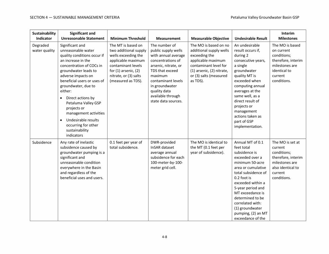
Degraded water quality
Significant and unreasonable water quality conditions occur if an increase in the concentration of COCs in groundwater leads to adverse impacts on beneficial users or uses of groundwater, due to either:
• Direct actions by Petaluma Valley GSP projects or management activities
• Undesirable results occurring for other sustainability indicators
The MT is based on two additional supply wells exceeding the applicable maximum contaminant levels for (1) arsenic, (2) nitrate, or (3) salts (measured as TDS).
The number of public supply wells with annual average concentrations of arsenic, nitrate, or TDS that exceed maximum contaminant levels in groundwater quality data available through state data sources.
The MO is based on no additional supply wells exceeding the applicable maximum contaminant level for (1) arsenic, (2) nitrate, or (3) salts (measured as TDS).
An undesirable result occurs if, during 2 consecutive years, a single groundwater quality MT is exceeded when computing annual averages at the same well, as a direct result of projects or management actions taken as part of GSP implementation.
The MO is based on current conditions; therefore, interim milestones are identical to current conditions.
Subsidence Any rate of inelastic subsidence caused by groundwater pumping is a significant and unreasonable condition everywhere in the Basin and regardless of the beneficial uses and users.
0.1 feet per year of total subsidence.
DWR-provided InSAR dataset average annual subsidence for each 100-meter-by-100-meter grid cell.
The MO is identical to the MT (0.1 feet per year of subsidence).
Annual MT of 0.1 feet total subsidence is exceeded over a minimum 50-acre area or cumulative total subsidence of 0.2 foot is exceeded within a 5-year period and MT exceedance is determined to be correlated with: (1) groundwater pumping, (2) an MT exceedance of the
The MO is set at current conditions; therefore, interim milestones are also identical to current conditions.

SECTION 4 — SUSTAINABLE MANAGEMENT CRITERIA Petaluma Valley Groundwater Basin GSP
4-9
Sustainability Indicator
Significant and Unreasonable Statement Minimum Threshold Measurement Measurable Objective Undesirable Result
Interim Milestones
chronic lowering of groundwater-level SMC (that is, groundwater levels have fallen below historical lows).
Depletion of ISW
Significant and unreasonable depletion of surface water from interconnected streams occurs when surface water depletion, caused by groundwater pumping within the Basin, exceeds historical depletion or adversely impacts the viability of GDEs or other beneficial users of surface water.
Maintain estimated streamflow depletions below historical maximum amounts.
Metric: Shallow groundwater elevations are used as a proxy for stream depletion. The MT is set at 1 foot below the 2020 dry-season average minimum groundwater levels.
Monthly-averaged groundwater levels measured in representative monitoring points (shallow monitoring wells near ISW).
The MO is to maintain groundwater levels within historical observed ranges.
Metric: The halfway point between the MT value and the average observed dry-season surface water stage from November 2019 to December 2020.
Undesirable result occurs if MT is exceeded at two wells during dry years or at one well during normal and wet years.
To be determined based on scenario modeling results.
COC = constituent of concern RMP = representative monitoring point TDS = total dissolved solids

SECTION 4 — SUSTAINABLE MANAGEMENT CRITERIA Petaluma Valley Groundwater Basin GSP
4-10
4.5 Chronic Lowering of Groundwater Levels SMC The chronic lowering of groundwater levels was the first sustainability indicator addressed in the SMC process described in Section 4.3, because it contains the most readily available and robust datasets and is directly related to most of the other indicators. Additionally, SGMA allows for the use of groundwater levels as a proxy for other sustainability indicators if a significant correlation is established between groundwater levels and the other metrics. In this GSP, groundwater levels are used as a proxy for two other sustainability indicators: reduction of groundwater storage and depletion of ISW. This is further described in Sections 4.6 and 4.10, respectively.
For the chronic lowering of groundwater-level SMC, the following SGMA definition of an undesirable result assisted in characterizing significant and unreasonable conditions for the Basin and establishing the SMC described below:
• The chronic lowering of groundwater levels indicating a significant and unreasonable depletion of supply if continued over the planning and implementation horizon.
• Overdraft during a period of drought is not sufficient to establish that there is a chronic lowering of groundwater levels if extractions and groundwater recharge are managed as necessary to ensure that reductions in groundwater levels or storage during a period of drought are offset by increases in groundwater levels or storage during other periods.
As described in Section 3.2.2, the majority of wells with available historical data exhibit generally stable groundwater-level trends with typical seasonal variations (that is, higher groundwater levels in the spring and lower groundwater levels in the fall). Observed groundwater-level elevations predominantly remain above sea level except for some wells in the southern portion of the Basin near the Baylands and the tidally influenced reach of the Petaluma River. Several wells near the upper reaches of Lynch Creek near the northeastern boundary of the Basin and along the northern boundary of the Basin exhibit decreasing groundwater-level trends over the period of record.
Taking these conditions and stakeholder input into account, the following overall approach guided development of the SMC for the chronic lowering of groundwater levels:
1. For areas with stable trends, maintain groundwater levels within or near historical conditions while accounting for future droughts and climate variability.
2. For areas with declining trends, protect beneficial users that could be impacted by the declining groundwater levels and stabilize and reverse the declining trends.
4.5.1 Locally Defined Significant and Unreasonable Conditions Locally defined significant and unreasonable conditions were determined based on public meetings and discussions with GSA staff, Advisory Committee members, and the GSA Board.

SECTION 4 — SUSTAINABLE MANAGEMENT CRITERIA Petaluma Valley Groundwater Basin GSP
4-11
Significant and unreasonable chronic lowering of groundwater levels in the Basin was defined as follows:
Chronic lowering of groundwater levels that significantly exceed historical levels or cause significant and unreasonable impacts on beneficial users, such as the following:
• Declining groundwater levels that limit the ability of domestic, municipal, or agricultural well owners to access groundwater for beneficial uses (for example, groundwater levels falling below pumping depths of water supply wells), causing significant and unreasonable economic burden on those who rely on basin groundwater
• Groundwater levels falling near basin boundaries that indicate impacts on or from neighboring basins
• Falling groundwater levels that cause impacts on groundwater-dependent vegetation
4.5.2 Minimum Thresholds Section 354.28 (c)(1) of the GSP Regulations states that “The minimum threshold for chronic lowering of groundwater levels shall be the groundwater elevation indicating a depletion of supply at a given location that may lead to undesirable results.” The GSP Regulations further specify that MTs for the chronic lowering of groundwater levels are to be supported by information on the rate of groundwater elevation decline based on historical trends, water year type, projected water use in the basin, and potential effects on other sustainability indicators.
The process for developing the MTs for the chronic lowering of groundwater levels involved the development of numerous alternatives for stakeholder consideration that took into account (1) the GSP Regulations cited in previous subsections; (2) the approach described in the first part of this subsection for considering differing patterns of historical groundwater-level trends; and (3) the significant and unreasonable statement provided in Section 4.5.1. The alternatives were developed on behalf of the GSA by Sonoma Water staff and subconsultants based on an evaluation of historical groundwater elevations over the available period of record (including consideration of average water levels over various time periods, long-term trends, response to the recent drought, and the like), well construction data, and input from stakeholders. The following subsections provide details on the development of MTs.
4.5.2.1 Information and Methodology Used to Establish Chronic Lowering of Groundwater Levels Minimum Thresholds
The information used for establishing the MTs for the chronic lowering of groundwater levels sustainability indicator included:
• Historical groundwater elevation data
• Depths and locations of existing wells

SECTION 4 — SUSTAINABLE MANAGEMENT CRITERIA Petaluma Valley Groundwater Basin GSP
4-12
• Maps of current and historical groundwater elevation data
• Input from stakeholders regarding significant and unreasonable conditions and desired current and future groundwater elevations communicated during public meetings
• Results of modeling of future groundwater-level conditions
As described in the previous subsections and in Section 3.2.2, different patterns of historical groundwater-level trends are observed within the Basin with areas exhibiting long-term stable groundwater-level trends and areas with historical declining trends that have exhibit recovered or recovering groundwater levels. To account for the distinct patterns of historical groundwater-level trends observed within the Basin, different methodologies for calculating MTs were applied to the following two categories of RMPs based on observed patterns in historical and recent groundwater-level trends:
• RMPs with relatively stable long-term groundwater levels defined as less than 0.5 foot per year of decline with evidence of recovery following wet years
• RMPs exhibiting groundwater-level declines (greater than 0.5 foot per year of decline with limited recovery in wet years)
These two different patterns were distinguished based on trend lines calculated by linear regression of observed groundwater levels at each RMP (or from a similarly constructed nearby monitoring well where historical records are limited). Figure 4-1 shows the locations of the RMPs, and which RMPs are associated with each pattern. The calculated trends are included with the hydrographs in Appendix 4-1.
The MTs were set at each RMP based on the three following primary factors:
1. Review of groundwater-level data and hydrographs to identify the lowest historical groundwater elevation at each RMP after removing any measurements flagged as “questionable measurements” or otherwise anomalous measurements from the datasets.
2. Calculation of “well impact depths” in the vicinity of each RMP to identify depths at which the lowering of groundwater levels may impact well users, including domestic, agricultural, public supply, and industrial wells.
3. Calculation of a “drought factor or buffer” to account for reasonably foreseeable future droughts at each RMP with recent groundwater levels that are not below or approaching the above calculated well impact depth.

SECTION 4 — SUSTAINABLE MANAGEMENT CRITERIA Petaluma Valley Groundwater Basin GSP
4-13
Figure 4-1. Representative Monitoring Points for Chronic Lowering of Groundwater Level

SECTION 4 — SUSTAINABLE MANAGEMENT CRITERIA Petaluma Valley Groundwater Basin GSP
4-14
Calculation of Well Impact Depths The methodology for incorporating the potential impact on existing well users involved the statistical evaluation of known completion information for water supply wells located within the vicinity of each potential RMP. These statistics were calculated by drawing polygons for each potential RMP area and querying Sonoma Water’s Water Well Database (sourced from DWR’s Online System for Well Completion Reports, Permit Sonoma, and the USGS). Generally, the Basin boundary and midpoints between potential RMPs were used to draw the vicinity areas. In some cases, physical features that appear to have a direct influence on groundwater movement were used as boundaries of the vicinity areas. For each vicinity area polygon, the total number of supply wells, the shallowest supply well total depth, the 95th percentile shallowest supply well total depth, and the average supply well depth were calculated. For each RMP, the analysis included all types of supply wells contained within the datasets (domestic wells, irrigation wells, public supply wells, and industrial wells).
Factoring for Future Drought Conditions A factor to account for reasonably foreseeable future droughts was calculated for each RMP using the following methodology:
• For wells with 10 or more years of historical data, the largest consecutive 4-year decline during historical dry periods was used
• For wells with fewer than 10 years of historical data, the future simulated largest consecutive 4-year decline was used
As the degree of groundwater-level responses to yearly climate conditions varies based on localized hydrogeologic condition, calculating a factor specific to each RMP incorporates observed groundwater-level responses specific to each RMP vicinity area into the MTs. The calculated drought factors range from 3 to 20 feet.
The historical lows minus the drought factor were applied as the MT to RMPs where this level is above the well impact depth. For RMPs where the well impact depth is shallower than the historical low minus the drought buffer, the well impact depth was applied as the MT. Table 4-2 provides a summary of these metrics and presents the final criteria used for calculating the MT at each RMP. As indicated in Table 4-2, MTs for 3 of the 12 RMPs represent the calculated well impact depths (that is, at these locations the well impact depth is shallower than the historical low with the drought factor and is considered more protective of beneficial users). At the nine remaining RMPs the MTs based on the historical lows minus the drought factor were determined to be above (that is, protective of) the calculated well impact depths.

SECTION 4 — SUSTAINABLE MANAGEMENT CRITERIA Petaluma Valley Groundwater Basin GSP
4-15
Table 4-2. Summary of Calculations for Minimum Thresholds and Measurable Objectives Stable Wells MT MO
Well ID Observed Historical
Low (ft msl)
Year of Observed Historical
Low
Calculated Drought
Factor (ft) Drought
Factor Years
Historic Low minus
Drought Factor
(ft msl)[a]
Well Impact Depths (ft
msl)[a] 95th
Shallower of Historical
Low minus 4-year Drought
or well impact depth
Historical Spring
Median (entire)
Pet0006 -27.8 2020 -19.0 Projected -47 -39 -39 -10
Pet0010 31.5 2015 -3.0 2012-2015 29 -11 29 35
Pet0012 80.5 2014 -3.5 Projected 77 3 77 84
Pet0013 24.4 2019 -3.0 Projected 21 -38 21 33
Pet0017 -58.1 1990 -20.0 2011-2014 -78 -41 -41 -1
Pet0043 82.0 2011 -8.0 1989-1993 74 51 74 115
Pet0172 13.0 2019 N/A N/A 13 -19 13 15
Pet0173 45.1 2019 N/A N/A 45 -19 45 49
Pet0174 58.6 2020 N/A N/A 59 7 59 60
Declining Wells MT MO
Well ID Observed Historical
Low
Year of Observed Historical
Low
Calculated Drought Factor
Drought Factor Years
Historic Low minus
Drought Factor
Well Impact Depths (ft
msl)[a] 95th
Shallower of Historical
Low or well impact depth
Historical Spring
Median (pre-2010)
Pet0023 139.8 2020 -20 Projected 120 7 120 200
Pet0036 111.6 2020 -15.5 1989-1993 96 52 96 132
Pet0042 52.2 2018 -14 Projected 38 52 52 121 [a] Bold values indicate criteria used for final MT value.

SECTION 4 — SUSTAINABLE MANAGEMENT CRITERIA Petaluma Valley Groundwater Basin GSP
4-16
Adaptive Management to Address Data Gaps and Improve/Refine SMC There is appreciable uncertainty regarding the SMC developed for the chronic lowering of groundwater levels sustainability indicator. Specific planned data collection activities that will inform future adjustments or refinements to the chronic lowering of groundwater-level SMC include:
• Refine information on the depths of nearby water wells from the well log database and information obtained through future well registration program implementation
• Improve mapping and correlation of well depth data with stratigraphic data
• Assess and develop plans to fill data gaps in monitoring networks through targeted additional dedicated monitoring wells and suitable volunteered private wells based on:
o hydrogeologic properties and geologic features o areas of boundary inflows and outflows o distribution of pumping o location of sensitive beneficial users (for example, shallow well owners, ecosystems)
4.5.2.2 Relationship between Individual Minimum Thresholds and Relationship to Other Sustainability Indicators
Section 354.28 of the GSP Regulations requires that the description of all MTs include a discussion of the relationship between the MTs for each sustainability indicator. In the SMC Best Management Practices document (DWR 2017), DWR clarified that the GSP must describe the relationship between each sustainability indicator’s MT by describing why or how a water level MT set at a particular RMP is similar to or different to water level thresholds in a nearby RMP. Additionally, the GSP must describe the relationship between the selected MTs and MTs for other sustainability indicators.
Groundwater elevation MTs are derived from examination of the historical record reflected in hydrographs at each individual RMP and depths of nearby water wells. Therefore, the MTs are unique at every well, but when combined represent reasonable and achievable groundwater conditions and flowpaths.
An assessment of how other sustainability indicators could be influenced by the chronic lowering of groundwater levels MT indicates the following:
• Reduction in groundwater storage. Changes in groundwater elevations are directly correlated to changes in the amount of groundwater in storage and groundwater levels are used as a proxy for the reduction in groundwater storage sustainability indicator. The groundwater elevation MTs are set to establish a minimum elevation that will not lead to undesirable conditions, and that is acceptable to the stakeholders in the area. Therefore, if the groundwater elevation MTs are met, they will not result in long-term significant or unreasonable changes in groundwater storage.

SECTION 4 — SUSTAINABLE MANAGEMENT CRITERIA Petaluma Valley Groundwater Basin GSP
4-17
• Seawater intrusion. A significant and unreasonable condition for seawater intrusion is seawater intrusion inland of areas of existing brackish groundwater that may affect beneficial uses of groundwater. While the available data do not indicate increasing trends in salinity indicators in wells located near the Baylands, lower groundwater elevations, particularly in areas near the margins of the Baylands, could cause seawater to advance inland. For areas with declining groundwater levels, MTs are set near or at recent groundwater elevations with the goal of halting chronic groundwater-level declines. Therefore, the groundwater elevation MTs are intended to not exacerbate, and may help control, the rate of seawater intrusion.
• Degraded water quality. A significant and unreasonable condition for degraded water quality would occur if an increase in the concentration of COCs in groundwater leads to adverse impacts on beneficial users or uses of groundwater, due to direct actions by Petaluma Valley GSP projects or management activities or undesirable results occurring for other sustainability indicators. The chronic lowering of groundwater levels could potentially impact water quality by inducing poor-quality water into areas not previously impacted by water quality degradation. However, because MTs are set to avoid significant declines of groundwater levels below historically observed levels, this is not expected to occur.
• Subsidence. A significant and unreasonable condition for subsidence is the occurrence of inelastic subsidence caused by groundwater pumping. While continued decline of groundwater levels due to groundwater pumping within the Basin could trigger inelastic subsidence in areas with clay-rich aquifer materials, because MTs are set to avoid significant declines of groundwater levels below historically observed levels, this is not expected to occur.
• Depletion of ISW. MTs for the chronic lowering of groundwater levels do not promote additional pumping and aim to maintain groundwater elevations near historical levels in the vicinity of ISW. Therefore, the chronic lowering of groundwater elevations MTs is not anticipated to result in a significant or unreasonable depletion of ISW.
4.5.2.3 Effect of Minimum Thresholds on Neighboring Basins and Subbasins The Petaluma Valley Basin has two neighboring subbasins that are categorized as medium priority and are also subject to SGMA: the Santa Rosa Plain Subbasin to the north and the Sonoma Valley Subbasin to the east. The Petaluma Valley Basin is also adjacent to the very low-priority Wilson Grove Formation Highlands Basin to the northwest and Novato Valley Basin to the southwest, both of which are not subject to SGMA.
The boundary between the Petaluma Valley Basin and Santa Rosa Plain Subbasin coincides with a surface watershed divide between the Petaluma River watershed and the Laguna de Santa Rosa watershed. The boundary is also the approximate location of a groundwater flow divide; however, no known structural or geologic features restrict flow between the two areas and groundwater-level changes on one side of the boundary have the potential to influence groundwater levels on the other side. During the historical groundwater-level declines that

SECTION 4 — SUSTAINABLE MANAGEMENT CRITERIA Petaluma Valley Groundwater Basin GSP
4-18
occurred in the southern portions of the Santa Rosa Plain Subbasin through the early 2000s, no impacts on wells located within the adjacent areas of the Petaluma Valley Basin are known to have occurred. Similarly, no known impacts on wells located within the Santa Rosa Plain Subbasin have occurred related to the limited groundwater-level declines occurring within wells located in the Petaluma Valley Basin near the shared boundary. Because the MTs for the chronic lowering of groundwater aim to maintain groundwater levels above historical lows within the Petaluma Valley Basin, the potential for any negative effects to occur within the Santa Rosa Plain Subbasin related to the MTs for the chronic lowering of groundwater levels is limited.
Groundwater flow between the Petaluma Valley Basin and the Sonoma Valley Subbasin occurs only in the southeastern margins of the Basin in the Baylands area where very little groundwater use occurs due to the natural presence of brackish water. The shared boundary between the Petaluma Valley Basin and the Novato Valley Basin to the southwest is also an area of limited groundwater use within the Baylands area. There are also no GSP projects or management actions planned for these areas of the Basin that might change hydraulic gradients near these shared boundaries. Therefore, the MTs for chronic lowering of groundwater, which aim to maintain groundwater levels near current levels, are unlikely to affect groundwater conditions along these two boundaries.
The boundary between the Petaluma Valley Basin and the Wilson Grove Formation Highlands Basin generally follows the contact between the Quaternary alluvial deposits and the Wilson Grove Formation, with the exception of the City of Petaluma, where the boundary follows the jurisdictional boundary of the City and extends into a portion of the Wilson Grove Formation. Available groundwater-level data along the boundary and information from the simulated water budget indicate that the basins are connected, with groundwater from the Wilson Grove Formation Highlands Basin representing an important source of inflow to the Petaluma Valley Basin. Therefore, groundwater-level changes on one side of the boundary have the potential to influence groundwater levels on the other side. Because the MTs for the chronic lowering of groundwater levels aim to maintain groundwater levels above historical lows within the Petaluma Valley Basin, the potential for any negative effects to occur within the Wilson Grove Formation Highlands Basin related to the MTs for the chronic lowering of groundwater levels is limited.
While not required to be evaluated by SGMA, the potential effect of the chronic lowering of groundwater-level MTs are also very unlikely to influence groundwater levels in other adjoining areas that are not classified as groundwater basins or subbasins by DWR. Groundwater use in these upland areas that flank the eastern and western boundaries of the Basin primarily occurs within the Sonoma Volcanics upgradient of the Basin.
The Petaluma Valley GSA coordinated closely with both the Sonoma Valley and Santa Rosa Plain GSAs; they both set MTs to ensure that they do not prevent each other from achieving sustainability. All three GSAs followed a similar approach and methodology for setting and monitoring MTs. The potential for impacts to occur along all of the above-described boundaries

SECTION 4 — SUSTAINABLE MANAGEMENT CRITERIA Petaluma Valley Groundwater Basin GSP
4-19
will be evaluated as part of the GSA’s routine monitoring and reporting program, which includes both RMP wells and other wells monitored for groundwater levels in the Basin and contributing watershed areas. Additionally, the Sonoma Valley GSA will continue to closely coordinate with neighboring GSAs and the County for areas that are not under a GSA’s jurisdiction should any future issues arise.
4.5.2.4 Effect on Beneficial Uses and Users MTs for the chronic lowering of groundwater levels are set at the more protective of historical low conditions with allowances for future droughts and the depths at which existing wells could be impacted by the lowering of groundwater levels. The MTs are generally advantageous to beneficial users and land uses in the Basin as described in the following paragraphs.
Agricultural land uses and users. The chronic lowering of groundwater-level MTs protects existing agricultural users’ ability to meet typical demands by maintaining groundwater levels near current conditions. However, the chronic lowering of groundwater-level MTs places a practical limit on the acceptable lowering of groundwater levels in the Basin, thus conceptually restricting future levels of agriculture in the Basin beyond what is projected in the 50-year baseline scenario without projects to supplement water supplies, or management actions to limit future pumping increases. Should this occur, projects and management actions discussed in Section 6 will be considered for implementation to allow for alternatives to limitations on future agricultural pumping.
Urban land uses and users. The chronic lowering of groundwater-level MTs protects existing municipal and industrial groundwater users’ ability to meet typical demands by maintaining groundwater levels near current conditions. However, the chronic lowering of groundwater-level MTs does place a practical limit on the acceptable lowering of groundwater levels in the Basin, thus conceptually restricting future levels of municipal pumping in the Basin beyond what is projected in the 50-year baseline scenario without projects to supplement water supplies, or management actions to limit future pumping increases. Should this occur, projects and management actions discussed in Section 6 will be considered for implementation to allow for alternatives to limitations on future municipal pumping.
Domestic land uses and users. The chronic lowering of groundwater-level MTs are established to protect as many rural residential domestic wells as possible. Therefore, the MTs will likely have an overall beneficial effect on existing domestic land uses by protecting the ability to pump from domestic wells within the Basin.
Ecological land uses and users. Maintaining groundwater near or above historical levels will maintain the connected nature of groundwater and surface water in the Basin. This will protect GDE habitat and generally benefit environmental land uses and users
4.5.2.5 Relation to State, Federal, or Local Standards No federal, state, or local standards exist that are specific to the chronic lowering of groundwater levels.

SECTION 4 — SUSTAINABLE MANAGEMENT CRITERIA Petaluma Valley Groundwater Basin GSP
4-20
4.5.2.6 Method for Quantitative Measurement of Minimum Thresholds Depth to groundwater will be directly measured at the RMPs identified in Section 5.3.1 for comparison to MTs. The RMP network includes 12 existing wells, plus 4 new multi-level monitoring wells, resulting in a total of 16 RMPs. The groundwater-level data will be collected in accordance with the monitoring protocols outlined in Section 5.3.1 and converted to groundwater elevation by subtracting the measured depth to water from the reference point elevation used to take the depth to water measurement.
Available groundwater-level data, including historical data used for the calculation of the MTs and MOs, contain a variety of measurement frequencies ranging from hourly to semiannually. Groundwater-level measurement frequency for the 12 existing wells in the RMP monitoring networks includes the following:
• Two measured more than once per day • Four measured monthly • Six measured semiannually
As indicated in Section 5.3.1, the goals for groundwater-level measurement frequency will be: (1) measure groundwater levels at least monthly for all RMPs during GSP implementation, and (2) use pressure transducers where feasible to provide a higher level of quality control, so that potential short-term or residual pumping influences can be identified and flagged. Consistent with the monitoring protocols, only static groundwater levels will be compared to MTs.
For reporting seasonal highs and lows for future comparison with MTs, all sub-daily measurements will be reported as monthly averages to better align with the measurement frequency within historical datasets used to calculate the MTs. During GSP implementation, individual groundwater-level measurements collected manually and by data loggers will be reviewed for quality control and analyzed for MT exceedances during compilation of GSP annual and 5-year update reports.
GSA staff has identified data gaps in some areas of the Basin in the monitoring networks discussion (Section 5). The GSP includes a plan to expand the monitoring network as described in the implementation discussion (Section 7).
4.5.3 Measurable Objectives MOs for the chronic lowering of groundwater levels represent target groundwater elevations for 2042, considering realistic project implementation and allowing for operational flexibility over a range of climate and hydrologic variability.
4.5.3.1 Method for Setting Measurable Objectives Similar to the approach and methodology used for setting MTs, MOs are reflective of the distinct patterns of historical groundwater-level trends observed within the Basin.

SECTION 4 — SUSTAINABLE MANAGEMENT CRITERIA Petaluma Valley Groundwater Basin GSP
4-21
For RMPs exhibiting relatively stable long-term groundwater-level trends, the MO is calculated as the historical median spring groundwater elevation, because the aim of the MO is to maintain groundwater levels within historical ranges for these areas.
For RMPs exhibiting historical or recent declining trends, the MO is calculated as the median of spring groundwater elevations that occurred prior to the onset of declining trends, because the aim of the MO is stabilize and reverse the declining trends in these areas.
MOs for each RMP are listed in Table 4-2.
4.5.3.2 Interim Milestones For RMPs exhibiting relatively stable long-term groundwater-level trends, the MO is essentially set at recent conditions (that is, the aim of the MO for these wells is to maintain groundwater levels within historical and recent ranges); therefore, interim milestones are essentially equivalent to the MO throughout the GSP implementation period.
Interim milestones for RMPs exhibiting historical chronic groundwater-level declines are estimated using the expected benefit (positive change in groundwater elevations) from the projects and actions simulations compared to the baseline.
Note: Interim milestones for wells exhibiting historical chronic groundwater-level declines are still being calculated from model output and will be included in next review draft of this section.
4.5.4 Undesirable Results
4.5.4.1 Criteria for Defining Undesirable Results The chronic lowering of groundwater levels undesirable result is a quantitative combination of groundwater elevation MT exceedances. For the Basin, the specific groundwater condition that constitutes an undesirable result is:
Groundwater levels in 25 percent of the RMPs exceed their minimum thresholds for three consecutive fall measurements.
Consistent with DWR guidance, if MT exceedances are caused by emergency operational issues or droughts that extend for longer than the 4-year drought factor incorporated into the MTs (as described in Section 4.5.2.1), it is not considered an undesirable result unless the groundwater levels do not rebound to above the MTs during future normal and wet years following long-term droughts. [1]
[1] The SMC BMP (DWR 2017) provides information on how droughts may affect the groundwater-level SMC: “Undesirable results are one or more of the following effects: Chronic lowering of groundwater levels indicating a significant and unreasonable depletion of supply if continued over the planning and implementation horizon. Overdraft during a period of drought is not sufficient to establish a chronic lowering of groundwater levels if

SECTION 4 — SUSTAINABLE MANAGEMENT CRITERIA Petaluma Valley Groundwater Basin GSP
4-22
Exceedances of MTs at a single well will require investigation to determine if any actions should be considered to avoid potential future onset of undesirable results, as described in Section 4.5.4.2.
The 3 consecutive years of MT exceedances was selected by the GSA Board to (1) balance protection of beneficial users with costs related to response actions, and (2) limit the potential for shorter-duration MT exceedances that may not be chronic in nature to trigger undesirable results.
4.5.4.2 Potential Causes of Undesirable Results The potential causes of undesirable results for chronic lowering of groundwater-level results include:
• increased groundwater pumping in the Basin leading to chronic groundwater-level declines
• a significant reduction in natural recharge as a result of climate change, reduced groundwater and surface water interaction, or other land surface processes
If the location and volumes of groundwater pumping change as a result of unforeseen rural residential, agricultural, and urban growth that depend on groundwater as a water supply without supplemental supplies, these increased demands might lower groundwater to undesirable levels. Reduction in recharge or changes in rainfall patterns could also lead to more prolonged periods of lowered groundwater levels than have occurred historically.
As described in Section 6, projects and actions are being considered for implementation and/or contingency plans to augment recharge and reduce groundwater pumping to mitigate the potential for these conditions to occur.
Additionally, to respond to these potential conditions prior to the onset of an undesirable result, the following actions would be implemented if an MT is exceeded at a single RMP that does not trigger an undesirable result:
• Review the available data from the full monitoring network (that is, non-RMP monitoring wells) to assess the potential scale of areas exhibiting declines
• Assess whether the exceedance is climate-related
• Review any known or potential changes in groundwater pumping patterns (for example, new wells brought online, changes in land/water use, and the like), as needed
• Consider whether additional RMPs are needed
extractions and groundwater recharge are managed as necessary to ensure that reductions in groundwater levels or storage during a period of drought are offset by increases in groundwater levels or storage during other periods.”

SECTION 4 — SUSTAINABLE MANAGEMENT CRITERIA Petaluma Valley Groundwater Basin GSP
4-23
• Share information with nearby well owners, as appropriate
• Consider planning or implementing projects/actions, as appropriate (for example, begin with lower cost and/or voluntary projects/actions)
The approach is a proactive means for avoiding the exceedance of undesirable results when warning signs are available. Not all actions would be implemented for each individual exceedance of an MT. The tasks described above would generally be performed sequentially based on the potential severity of the occurrence.
4.5.4.3 Effects on Beneficial Users and Land Use The potential effects of undesirable results of the chronic lowering of groundwater levels on beneficial users and land use could be the inability of a significant number of private, agricultural, and M&I production wells from supplying groundwater to meet their water demands. Lowered groundwater levels reduce the saturated thickness of aquifer from which wells can pump, which could lead to increased pumping costs, reduced pumping capacity, or the need to drill new deeper wells. This would effectively increase the cost of using groundwater as a water source for all users. Avoiding undesirable results for the chronic lowering of groundwater levels will limit the potential for these conditions to occur in the future.
4.6 Reduction in Groundwater Storage Sustainable Management Criteria The reduction in groundwater storage SMC will be evaluated using groundwater levels as a proxy based on well-established hydrogeologic principles that the volume of groundwater in storage is directly proportional to groundwater elevations. The groundwater elevation MTs and MOs are established to maintain adequate groundwater supplies for all beneficial uses and users. Therefore, preventing groundwater elevations from dropping below MTs, by definition, maintains an adequate amount of water in storage. Maintaining groundwater elevations within the operational range between MTs and MOs is equivalent to no long-term change in storage.
4.6.1 Locally Defined Significant and Unreasonable Conditions Locally defined significant and unreasonable conditions were determined based on public meetings and discussions with GSA staff, Advisory Committee members, and the GSA Board. A significant and unreasonable reduction in groundwater storage in the Basin is defined as:
Reduction of groundwater storage that causes significant and unreasonable impacts on the long-term sustainable beneficial use of groundwater in the basin, as caused by:
• Long-term reductions in groundwater storage • Pumping exceeding the sustainable yield

SECTION 4 — SUSTAINABLE MANAGEMENT CRITERIA Petaluma Valley Groundwater Basin GSP
4-24
4.6.2 Minimum Thresholds Section 354.28(c)(2) of the GSP Regulations states that “The minimum threshold for reduction of groundwater storage shall be a total volume of groundwater that can be withdrawn from the basin without causing conditions that may lead to undesirable results. Minimum thresholds for reduction of groundwater storage shall be supported by the sustainable yield of the basin, calculated based on historical trends, water year type, and projected water use in the basin.”
This GSP will monitor changes in the groundwater levels at the RMPs as a proxy for the change in groundwater storage metric. As allowed in Section 354.36(b)(1) of the GSP Regulations, groundwater elevation data at the RMPs will be reported annually as a proxy to track changes in the amount of groundwater in storage.
Based on well-established hydrogeologic principles, stable groundwater elevations maintained above the MTs will indicate that groundwater storage is not being depleted (Freeze and Cherry 1979). Therefore, using groundwater elevations as a proxy, the MT for groundwater storage will be met if the MTs for the chronic lowering of groundwater levels are not exceeded.
4.6.2.1 Information and Methodology Used to Establish Groundwater Storage Minimum Thresholds
Similar to the chronic lowering of groundwater levels SMC, the information used for establishing the MTs for the groundwater storage sustainability indicator included:
• Historical groundwater elevation data
• Depths and locations of existing wells
• Maps of current and historical groundwater elevation data
• Input from stakeholders regarding significant and unreasonable conditions and desired current and future groundwater elevations communicated during public meetings
• Results of modeling of future groundwater-level conditions
4.6.2.2 Relationship between Individual Minimum Thresholds and Relationship to Other Sustainability Indicators
The MTs for the reduction in groundwater storage are the same as those used for the chronic lowering of groundwater sustainability. Because groundwater elevations will be used as a proxy for estimating changes in groundwater storage, the reduction in groundwater storage sustainability indicator cannot cause undesirable results for the chronic lowering of groundwater levels sustainability indicator.
The relationship between the groundwater storage sustainability indicator and other sustainability indicators is the same as the relationship between the chronic lowering of groundwater levels and other sustainability indicators, as described in Section 4.5.2.2.

SECTION 4 — SUSTAINABLE MANAGEMENT CRITERIA Petaluma Valley Groundwater Basin GSP
4-25
4.6.2.3 Effect of Minimum Thresholds on Neighboring Basins and Subbasins The Petaluma Valley Basin has two neighboring subbasins that are categorized as medium priority and are also subject to SGMA: the Santa Rosa Plain Subbasin to the north and the Sonoma Valley Subbasin to the east. The Petaluma Valley Basin is also adjacent to the very low-priority Wilson Grove Formation Highlands Basin to the northwest and Novato Valley Basin to the southwest, both of which are not subject to SGMA.
The potential effect of the groundwater storage MT on neighboring basins, subbasins, and other adjoining areas is the same as the relationship described for the chronic lowering of groundwater levels in Section 4.5.2.3.
4.6.2.4 Effect on Beneficial Uses and Users The MT for a reduction in groundwater storage will maintain stable average groundwater elevations and encourages minimal long-term net change in groundwater elevations and storage.
The potential effects of the groundwater storage MT on beneficial uses and users are the same as the potential effects described for the chronic lowering of groundwater levels in Section 4.5.2.4.
4.6.2.5 Relation to State, Federal, or Local Standards No federal, state, or local standards exist that are specific to groundwater storage.
4.6.2.6 Method for Quantitative Measurement of Minimum Thresholds Storage MTs will be measured by collecting groundwater-level measurements at the RMP sites in the monitoring network, as described in Sections 4.5.2.6 and 5.3.1. These data will be used to monitor groundwater elevations and compare with MTs.
Annual groundwater storage will also be calculated and reported by comparing changes in contoured groundwater elevations to assess changes in groundwater storage.
4.6.3 Measurable Objectives The change in a storage sustainability indicator was defined using groundwater levels as a proxy for the direct calculation of groundwater in storage. The same MTs and MOs are used as are defined in the chronic lowering of groundwater-level indicator to protect against a significant and unreasonable reduction in groundwater storage.
Additionally, even though groundwater levels are being used as a proxy in lieu of using the total volume of groundwater pumped, the achievement of MOs for the chronic lowering of groundwater levels will require that groundwater levels either increase or are maintained at their current levels. Therefore, the MOs will necessitate pumping within the sustainable yield

SECTION 4 — SUSTAINABLE MANAGEMENT CRITERIA Petaluma Valley Groundwater Basin GSP
4-26
calculated for the Basin in order to have no long-term change in storage once sustainability is reached.
4.6.3.1 Method for Setting Measurable Objectives The methods for setting the MO for groundwater storage incorporates the same methods for setting the MO for the chronic lowering of groundwater levels described in Section 4.5.3.1.
4.6.3.2 Interim Milestones Interim milestones for groundwater storage are the same as those established for the chronic lowering of groundwater levels. Achieving the chronic lowering of groundwater levels interim milestones will prevent long-term reductions in groundwater in storage.
4.6.4 Undesirable Results
4.6.4.1 Criteria for Defining Undesirable Results Groundwater in storage will be evaluated with the same MTs and MOs as the chronic lowering of groundwater levels sustainability criteria.
For the purposes of this GSP, the definition of undesirable conditions for the reduction of groundwater storage is the same as the following definition of the chronic lowering of groundwater levels:
Groundwater levels in 25 percent of the RMPs exceed their minimum thresholds for three consecutive fall measurements.
4.6.4.2 Potential Causes of Undesirable Results The potential causes of undesirable results for the reduction of groundwater storage are the same as those identified for the chronic lowering of groundwater levels in Section 4.5.4.2:
• Increased groundwater pumping in the Basin leading to chronic groundwater-level declines • A significant reduction in natural recharge as a result of climate change or other processes
4.6.4.3 Effects on Beneficial Users and Land Use The potential effects of undesirable results of groundwater storage on beneficial users and land use are the same as those identified for the chronic lowering of groundwater levels, as described in Section 4.5.4.3, which could include the inability of a significant number of private, agricultural, industrial, and M&I production wells from supplying groundwater to meet their water demands. Lowered groundwater levels reduce the thickness of saturated aquifer from which wells can pump, which could lead to increased pumping costs or the need to drill new deeper wells. This would effectively increase the cost of using groundwater as a water source for all users. Avoiding undesirable results for the chronic lowering of groundwater levels will limit the potential for these conditions to occur in the future.

SECTION 4 — SUSTAINABLE MANAGEMENT CRITERIA Petaluma Valley Groundwater Basin GSP
4-27
4.7 Seawater Intrusion SMC There are several factors to be considered when developing SMC for seawater intrusion, including the occurrence of significant and unreasonable conditions, the GSA’s ability to determine where and when seawater intrusion is occurring, and its relationship to groundwater pumping.
As indicated in Section 3.2.4.5 of the Basin Setting section, available data, although limited, do not indicate that seawater intrusion has been occurring and impacting beneficial users of groundwater. However, seawater intrusion has the potential to occur within the Basin due to observed declining groundwater levels, which have dropped below sea level in areas of the southern part of the Basin. Significant data gaps have been identified in the southern portions of the Basin that prevent adequate mapping and characterizing the distribution of salinity in groundwater, as identified in Section 3.1.8. In particular, groundwater quality data and well construction data are limited in this area and comprehensive monitoring infrastructure is lacking. The GSA has prioritized addressing these data gaps, as further described in Section 7, Implementation Plan, of this GSP.
Because of the significant data gaps, an adaptive approach for refining the initial SMC for seawater intrusion will be completed during GSP implementation. Additional characterization described in Section 7 will provide a more robust understanding of not only current conditions, but also potential future impacts from climate change (that is, sea level rise) and land-use practices in the Baylands area of the Basin.
4.7.1 Locally Defined Significant and Unreasonable Conditions Information relevant to the identification of significant and unreasonable conditions and development of SMC is summarized in the following paragraphs.
Naturally occurring brackish groundwater currently exists in the Baylands area. Freshwater and saltwater zones within coastal aquifers are separated by a transition zone (sometimes referred to as the zone of dispersion) where there is mixing of freshwater and saltwater. The transition zone is characterized most commonly by measurements of chloride concentrations in groundwater ranging from about 250 to 19,000 mg/L. As described in Section 3.2.4.5 of the Basin Setting, it is understood that the natural brackish groundwater in the Baylands area represents this transition zone of the Basin between the saline waters of San Pablo Bay and fresh groundwater from the more inland areas of the Basin north of the Baylands area.
The limited number of existing groundwater users in the Baylands do not appear to be negatively impacted by the brackish groundwater. As indicated on Figure 2-5 of Section 2, Plan Area, the majority of agricultural crops in the Baylands area are either not irrigated or use recycled water for irrigation. Existing beneficial uses of groundwater in this area are limited to very few agricultural and residential supply wells, which have been pumping groundwater influenced by brackish water for decades, indicating that beneficial users have not been negatively impacted by the natural brackish groundwater in this area. Therefore, current conditions are not considered a significant and unreasonable condition.

SECTION 4 — SUSTAINABLE MANAGEMENT CRITERIA Petaluma Valley Groundwater Basin GSP
4-28
Sea level rise impacts may occur in the future. According to communications with DWR SGMA staff during GSP development, because the impacts from sea level rise are not a result of GSA activities or groundwater pumping, the GSA is not required to address future impacts from sea level rise. It is expected that monitoring and assessment of sea level rise impacts, including the use of numerical modeling, will be ongoing throughout the implementation of the GSP.
Land-use changes affect the Baylands area. Historical changes in land use in the Baylands area of the Basin have affected the distribution of saline and fresh surface water, which, in turn, affect the distribution and occurrence of salinity in the underlying groundwater. GSA staff have had initial discussions with Sonoma Land Trust staff who are leading ongoing planning activities associated with wetlands restoration that could affect the occurrence and distribution of saline groundwater in the future. Although the GSA has no authority over such activities, the GSA will continue to coordinate with parties involved in the restoration activities and work with those parties to assess potential impacts of these projects on seawater intrusion that may affect beneficial uses of groundwater in the Basin.
Locally defined significant and unreasonable conditions were determined based on the above information and discussions at public meetings, and discussions with GSA staff, Advisory Committee members, and the GSA Board.
Significant and unreasonable conditions are defined as:
• Seawater intrusion inland of areas of existing brackish groundwater that may affect beneficial uses of groundwater.
• Examples of potential adverse impacts related to seawater intrusion are described in Sections 4.7.2.4 and 4.7.4.3.
4.7.2 Minimum Thresholds Section 354.28(c)(3) of the GSP Regulations states that “The minimum threshold for seawater intrusion shall be defined by a chloride concentration isocontour for each principal aquifer where seawater intrusion may lead to undesirable results.” The GSP Regulations require the following information to support the descriptions of the seawater intrusion MT and MO:
• Section 354.28(c)(3)(A): Maps and cross-sections of the chloride concentration isocontour that defines the MT and MO.
• Section 354.28(c)(3)(B): A description of how the seawater intrusion MT considers the effects of current and projected sea levels.
The seawater intrusion MT is defined as follows:
The minimum threshold for seawater intrusion is the 250 mg/L chloride isocontour located in an area that is protective of beneficial users of groundwater, as shown on Figure 4-2.

SECTION 4 — SUSTAINABLE MANAGEMENT CRITERIA Petaluma Valley Groundwater Basin GSP
4-29
Figure 4-2. Seawater Intrusion Minimum Threshold and Measurable Objective

SECTION 4 — SUSTAINABLE MANAGEMENT CRITERIA Petaluma Valley Groundwater Basin GSP
4-30
4.7.2.1 Information and Methodology Used to Establish Seawater Intrusion Minimum Thresholds and Measurable Objectives
The MT was defined in the aquifers as the 250 mg/L chloride concentration isocontour in order to protect beneficial use of groundwater outside the Baylands area, because native chloride concentrations in the inland portions of the Basin are generally below 100 mg/L. This concentration is the secondary drinking water maximum contaminant level (SMCL) for chloride and is also less than the chloride concentration that can be tolerated by grapes (262 mg/L) without showing adverse effects (University of California Cooperative Extension 2006). Hay cultivars also grown in this area are known to be tolerant of much higher chloride concentrations.
The Baylands area of the Basin near San Pablo Bay has very few wells used for groundwater supply because of the naturally brackish conditions. Consequently, minimal water quality monitoring has been conducted in this area in the past. Because there are significant monitoring well data gaps, the GSA lacks the data needed at this point to adequately map the current 250 mg/L chloride concentration isocontour and to confidently establish the most appropriate location for the MT. The following adaptive methodology uses existing data and provides management flexibility while data are collected during GSP implementation. This approach is anticipated to result in future updates and refinements of the seawater intrusion SMC:
1. The current 250 mg/L chloride isocontour is interpolated from existing groundwater monitoring data, which have been collected through several groundwater monitoring programs and span multiple years. It is understood that these data are not derived from RMPs, or collected contemporaneously; however, the data represents the best available information that currently exists. The estimated baseline 250 mg/L chloride isocontour developed from these data is shown on Figure 4-2 as the yellow isocontour.
2. The MT isocontour is initially set between (inland) of the baseline 250 mg/L chloride isocontour and areas with known existing water wells serving beneficial users, as shown on Figure 4-2. It is anticipated that the MT isocontour will be updated and refined in future GSP updates once additional data are available.
4.7.2.2 Relationship between Individual Minimum Thresholds and Relationship to Other Sustainability Indicators
Assessment of how other sustainability indicators could be influenced by the seawater intrusion MT indicates the following:
• Chronic lowering of groundwater levels. Nothing in the seawater intrusion MTs would promote additional pumping that could impact groundwater elevations. Therefore, the seawater intrusion MTs will not result in an exceedance of the chronic lowering of groundwater levels MT.

SECTION 4 — SUSTAINABLE MANAGEMENT CRITERIA Petaluma Valley Groundwater Basin GSP
4-31
• Change in groundwater storage. Nothing in the seawater intrusion MTs promotes pumping in excess of the sustainable yield. Therefore, the seawater intrusion MTs will not result in an exceedance of the groundwater storage MT.
• Degraded water quality. Because chloride is considered a constituent of concern for degraded water quality and the seawater intrusion MTs are designed to protect beneficial users from seawater intrusion (using chloride as an indicator), the seawater intrusion MTs may have a beneficial impact on groundwater quality by preventing increases in chloride concentrations in supply wells.
• Subsidence. Nothing in the seawater intrusion MTs promotes additional pumping that could cause subsidence. Therefore, the seawater intrusion MTs will not result in an exceedance of the subsidence MT.
• Depletion of ISW. Nothing in the seawater intrusion MTs promotes additional pumping or lower groundwater elevations adjacent to ISW. Therefore, the groundwater quality MTs will not result in a significant or unreasonable depletion of ISW.
4.7.2.3 Effect of Minimum Thresholds on Neighboring Basins and Subbasins The Petaluma Valley Basin has two neighboring subbasins that are categorized as medium priority and are also subject to SGMA: the Santa Rosa Plain Subbasin to the north and the Sonoma Valley Subbasin to the east. The Petaluma Valley Basin is also adjacent to the very low-priority Wilson Grove Formation Highlands Basin to the northwest and Novato Valley Basin to the southwest, both of which are not subject to SGMA. Because the Santa Rosa Plain Subbasin and Wilson Grove Formation Highlands Basin are not located near the coast, it is not anticipated that they would be affected by the seawater intrusion MTs in the Petaluma Basin.
Because the seawater intrusion MT is designed to prevent additional seawater intrusion related to groundwater pumping, it is unlikely that the MT for the Petaluma Valley Basin will prevent the neighboring Sonoma Valley GSA from achieving and maintaining sustainability. Similarly, it is unlikely that the MT for seawater intrusion will negatively impact the Novato Valley Basin for the same reasons. The Petaluma Valley GSA coordinated closely with the Sonoma Valley GSA to set MTs to ensure that they do not prevent each other from achieving sustainability. Both the Petaluma Valley and Sonoma Valley GSAs followed a similar approach and methodology for setting and monitoring MTs.
4.7.2.4 Effect on Beneficial Uses and Users The MT is the secondary drinking water standard, which is inherently protective of drinking water as a beneficial use. The MT is also less than the concentration of chloride thought to impact grapes and hay crops, which are the primary crops currently grown in this area. It is recognized that there are groundwater users within the brackish groundwater areas of the Basin with wells that exhibit elevated chloride concentrations (Figure 4-2). There are several vineyards in this area that use recycled water for irrigation purposes for that reason.

SECTION 4 — SUSTAINABLE MANAGEMENT CRITERIA Petaluma Valley Groundwater Basin GSP
4-32
The potential effects of the seawater intrusion MT on other beneficial uses and users in the Basin are as follows:
• Agricultural land uses and users. The seawater intrusion MTs generally provide positive benefits to the Basin’s agricultural water users. Preventing seawater intrusion ensures that a supply of usable groundwater will exist for beneficial agricultural use.
• Urban land uses and users. The seawater intrusion MTs generally provide positive benefits to the Basin’s urban water users. Preventing additional seawater intrusion will help ensure an adequate supply of groundwater for urban supplies.
• Domestic land uses and users. The seawater intrusion MTs generally provide positive benefits to the Basin’s domestic water users. Preventing additional seawater intrusion will help ensure an adequate supply of groundwater for domestic supplies.
• Ecological land uses and users. Although the seawater intrusion MTs do not directly benefit ecological uses, it can be inferred that the seawater intrusion MTs provide generally positive benefits to the Basin’s ecological water uses. Preventing additional seawater intrusion will help prevent unwanted high salinity levels from the coast from impacting ecological groundwater uses. Additionally, coordination between the GSA and entities involved in restoration activities within the Baylands area will help better identify and avoid potential effects on ecological water uses in this area.
4.7.2.5 Relation to State, Federal, or Local Standards While no federal, state, or local standards exist that are specific to seawater intrusion, the MT is set at the recommended SMCL for chloride established by the SWRCB DDW and is therefore consistent with existing available standards for drinking water.
4.7.2.6 Method for Quantitative Measurement of Minimum Thresholds As previously noted, and further described in Section 5, Proposed Monitoring Plan, the monitoring network for seawater intrusion represents a significant data gap that will need to be developed during the early stages of GSP implementation. Monitoring for seawater intrusion just north and along the perimeter of the San Pablo Baylands area will be conducted using a combination of existing water supply wells and additional proposed new dedicated monitoring wells constructed during implementation of the GSP, depending upon well access, construction, and funding availability. Until an adequate monitoring network is developed for seawater intrusion, chloride concentrations measured in groundwater samples from public supply wells within or near the margins of the Baylands area will be used to provide an indication of potential inland incursion of the chloride isocontour. The future monitoring network will be designed to more accurately map the location of the 250 mg/L chloride isocontour.
Future refinement of the SMC will be considered, as additional information is developed to better characterize and monitor the distribution of chloride in the aquifer.

SECTION 4 — SUSTAINABLE MANAGEMENT CRITERIA Petaluma Valley Groundwater Basin GSP
4-33
4.7.3 Measurable Objectives The MO for seawater intrusion is shown as being coincident with the baseline 250 mg/L chloride isocontour as shown on Figure 4-2 and is defined as follows:
The MO for seawater intrusion is the 250 mg/L chloride isocontour at the currently inferred interface of brackish groundwater.
The currently inferred interface of brackish groundwater is defined as the same location as the currently inferred 250 mg/L chloride isocontour. In other words, the goal of the MO is to protect beneficial users by maintaining this interface at its current location and avoiding any future inland incursion of seawater.
4.7.3.1 Method for Setting Measurable Objectives The MO isocontour was set at the best estimate of current conditions and will be refined with future monitoring data. The goal is to not move the brackish groundwater interface further inland, because it might then start to impact beneficial users of groundwater.
4.7.3.2 Interim Milestones The MOs for seawater intrusion are set at current conditions; therefore, the expected interim milestones are identical to current conditions.
4.7.4 Undesirable Results
4.7.4.1 Criteria for Defining Undesirable Results The seawater intrusion undesirable result is a quantitative combination of chloride concentrations MT exceedances.
Undesirable results for seawater intrusion occur in the Basin when two conditions are met:
1. Three consecutive years of MT exceedances (the MT exceedances occur when the monitoring data indicate that the current extent of groundwater with 250 mg/L of chloride is inland relative to the MT isocontour)
2. The MT exceedance is determined to be caused by groundwater pumping
The 3 consecutive years of MT exceedances was selected by the GSA Board to account for the (1) significant uncertainty associated with the mapping of the chloride isocontour due to current data limitations; and (2) potential future short-term (for example, drought-related or seasonal) incursions of the chloride isocontour that have historically occurred along the margins of the Baylands (Kunkel and Upson 1960).
To ensure that undesirable results are tied to conditions that the GSA can feasibly manage (that is, groundwater levels and groundwater pumping), a correlation methodology will be used to determine if seawater intrusion-related undesirable results have occurred as a result of

SECTION 4 — SUSTAINABLE MANAGEMENT CRITERIA Petaluma Valley Groundwater Basin GSP
4-34
groundwater-level declines due to groundwater pumping. This methodology will be implemented in conjunction with the GSP monitoring plan approach that includes regular evaluation of ongoing groundwater quality, including chloride monitoring, and groundwater elevation measurements and trend analysis.
Exceedance of a seawater intrusion MT will trigger implementation of the following methodology to determine if the seawater intrusion is related to groundwater pumping and, therefore, an undesirable result may be occurring that requires action:
• Review of related chloride and TDS groundwater quality data, including water year average and standard deviations, and multi-year averages and standard deviations
• Review of groundwater elevation measurements and trends in RMP and other nearby wells being monitored, including an assessment as to whether groundwater levels have declined below historical lows or sea level
• Evaluation of time series plots of groundwater levels relative to sea level, chloride, and TDS data from nearby monitoring wells
• Evaluation of known or estimated groundwater pumping patterns near potential seawater intrusion
• Numerical modeling to evaluate these reviews and evaluations, as necessary
• Compilation of pertinent data and assessment of any data gaps
These data will be evaluated to determine whether the cause of seawater intrusion is declining groundwater levels due to groundwater pumping, if this constitutes an undesirable result, and proposed actions needed to halt additional seawater intrusion in the future. Other methods may also be considered based on the specific occurrence and available data and technical tools at the time. Should future MT exceedances occur, the results of the correlation methodology review and evaluation of data and monitoring will be provided with annual reports submitted to DWR. Additionally, any seawater intrusion is of great concern to the GSA and would likely trigger additional studies and potential monitoring efforts to better assess and understand the hydrogeologic framework and causes to prevent further movement inland of chloride in groundwater.
4.7.4.2 Potential Causes of Undesirable Results Conditions that may lead to an undesirable result include groundwater-level declines along the northern margins of the tidal marshlands and the tidal reaches of the Petaluma River. Groundwater-level declines in these areas could trigger the inducement of brackish water into fresher groundwater aquifers and may impact water quality for beneficial use. Such groundwater-level declines could be caused by ongoing or additional future pumping from supply wells near the margins of the Baylands area.

SECTION 4 — SUSTAINABLE MANAGEMENT CRITERIA Petaluma Valley Groundwater Basin GSP
4-35
Other conditions, such as sea level rise or land-use changes (including planned restoration activities), could cause future MT exceedances; however, these are not conditions that the GSA has the ability or authority to control and would not be considered an undesirable result. The methodology described above will help determine whether the causes of potential future MT exceedances constitute an undesirable result. The GSA has initiated discussions and is committed to future close coordination with organizations leading the planned restoration activities to limit the potential for future undesirable results and to appropriately monitor effects of future restoration activities.
4.7.4.3 Effects on Beneficial Users and Land Use The primary detrimental effect on beneficial users and land uses from seawater intrusion is that the groundwater supply will become saltier and thus impact the use of groundwater for domestic/public supply and agricultural purposes. Seawater intrusion renders non-brackish groundwater essentially unusable for many beneficial users and land uses without expensive mitigation or treatment. Once seawater intrudes into aquifers, reversing and mitigating seawater intrusion can require significant resources and time to address and would significantly increase the cost of water for all users.
4.8 Degraded Water Quality SMC Unlike most other sustainability indicators, degraded water quality is the subject of robust federal, state, and local regulatory regimes carried out by a number of different entities and is not regulated by SGMA. The GSA is not responsible for enforcing existing water quality standards or collecting data to support existing water quality programs, nor is the GSA responsible for natural changes in groundwater quality or groundwater degradation caused by others. However, potential groundwater quality degradation needs to be considered during GSP development to ensure that activities associated with implementing the GSP, such as GSP projects and actions, do not degrade current water quality conditions.
One of the primary challenges in implementing the degraded water quality SMC will be to assess in the future whether any degradation to groundwater quality is due to SGMA activities, and specific projects and management actions may include focused groundwater quality monitoring as appropriate.
4.8.1 Locally Defined Significant and Unreasonable Conditions Locally defined significant and unreasonable conditions were determined based on public meetings and discussions with GSA staff, Advisory Committee members, and the GSA Board.
Significant and unreasonable water quality conditions occur if an increase in the concentration of constituents of concern in groundwater leads to adverse impacts on beneficial users or uses of groundwater, due to either:
1. Direct actions by Petaluma Valley GSP projects or management activities 2. Undesirable results occurring for other sustainability indicators

SECTION 4 — SUSTAINABLE MANAGEMENT CRITERIA Petaluma Valley Groundwater Basin GSP
4-36
Examples of potential adverse impacts are described in Sections 4.8.2.7 and 4.8.4.3.
As noted in Section 354.28 (c)(4) of the GSP Regulations, MTs are based on a degradation of water quality, not an improvement of water quality (CCR, 2016). Therefore, this GSP is designed to avoid taking any action that may inadvertently move groundwater constituents that have already been identified in the Basin in such a way that the constituents have a significant and unreasonable impact that would not otherwise occur. COCs were identified based on three criteria:
1. They have an established level of concern such as an MCL or SMCL, or a level that reduces crop production
2. They have been found in the Basin at levels above the level of concern and are routinely analyzed and reported through existing regulatory monitoring programs
3. The occurrence of the COC is extensive throughout the Basin
Based on the review of groundwater quality in Section 3.2.5, three COCs were identified that may affect groundwater supply in the Basin. The COCs include:
• Arsenic • Nitrate • Salinity (measured as TDS)
There are other point source contaminants found sporadically in the Basin, but these are not regional in extent, are monitored through various other regulatory programs, and consequently SMC are not established in the GSP. New or additional water quality constituents may be identified as potential COCs applicable to the GSP implementation activities through routine consultation and information sharing with other regulatory agencies. The GSA would then consider adding potential COCs and assigning SMC during the 5-year GSP updates.
Future GSP implementation projects or actions that require their own site-specific monitoring network would take into consideration any localized COCs and regulatory requirements.
4.8.2 Minimum Thresholds The GSP Regulations allow three options for setting degraded water quality MTs. Section 354.28(c)(2) of the GSP Regulations states that “The minimum threshold shall be based on the number of supply wells, a volume of water, or a location of an isocontour that exceeds concentrations of constituents determined by the Agency to be of concern for the basin.” In this Basin, MTs are based on a number of supply wells that exceed concentrations of constituents determined to be of concern for the Basin.
The currently available supply wells for monitoring COCs that have an MCL or SMCL are public supply wells. Should domestic wells or agricultural irrigation wells be incorporated into future

SECTION 4 — SUSTAINABLE MANAGEMENT CRITERIA Petaluma Valley Groundwater Basin GSP
4-37
monitoring programs established by the GSA or other entities, they could also be included in COC monitoring during future GSP updates.
4.8.2.1 Existing Water Quality Monitoring Programs and Networks The SMC is based on a number of supply wells, and the GSA identified sets of supply wells that are currently monitored (or are proposed to be monitored in the future) for various groundwater constituents and supply uses such as drinking water and irrigation water. Because these supply wells are monitored under different programs and may have different required sampling schedules (even under the same program), no one set of constituents will be sampled in all wells.
The goal is to use existing monitoring programs for supply well water quality assessment and not create new water quality monitoring networks that the GSA would be responsible for sampling. Initially, it is anticipated that RMPs will come from public supply wells that are already monitored. The only additional sampling the GSA would perform is on a project as-needed basis to specifically identify potential impacts on supply wells due to the development of a project related to GSP implementation (such as recharge ponds, aquifer storage and recovery, and similar facilities and activities.).
The only existing regional monitoring program identified in this Basin is public drinking water supply wells, regulated by the SWRCB DDW. Public drinking water supply wells are included in the water quality monitoring network because they are routinely sampled to meet CCR Title 22 water quality reporting requirements as regulated by the SWRCB DDW. Title 22 analyses include arsenic, nitrate, and TDS, which are the Basin COCs. This dataset can be obtained from the SWRCB through the GAMA online portal.
Existing and future water quality monitoring programs may be used to help collect data during GSP implementation and establish consistency with other programs. Additional information on each of the existing monitoring programs is provided in Table 4-3. Table 4-4 provides information on future monitoring networks to be used specifically for monitoring projects and management actions for GSP implementation.
Table 4-3. Petaluma Valley Basin Monitoring Networks Monitoring
Network Responsible
Party Type of Wells Constituents
Sampled Sampling
Frequency Purpose of Network
DDW Public Supply Wells
Cities and small water systems
Public supply Subset of Title 22 constituents
Varies Protect drinking water beneficials users

SECTION 4 — SUSTAINABLE MANAGEMENT CRITERIA Petaluma Valley Groundwater Basin GSP
4-38
Table 4-4. Future Monitoring Networks for Project-specific Monitoring Future As-needed
Monitoring Network
Responsible Party Type of Wells
Constituents Sampled
Sampling Frequency
Purpose of Network
Future Project Implementation Monitoring Network
GSA To be determined (public and private wells)
COCs identified as part of the GSP and constituents as required by the project permitting
To be determined
Identify water quality impacts related to site-specific project and action implementation
Each of these well networks are monitored for different purposes and overseen by different entities; therefore, sampling frequency and analytical suites vary. Water quality MTs for each well are selected based on which constituents are analyzed in water samples per existing programs, summarized in Table 4-5.
Table 4-5. Summary of Constituents Monitored at Each Well Network Constituent Public Supply SNMP
Arsenic
Nitrate
TDS
4.8.2.2 Level of Concern for each Constituent of Concern Each COC has an associated level of concern for each category of beneficial user. For the drinking water supply well category, the level of concern is represented by the MCL or SMCL, as applicable.
The San Francisco Bay Regional Water Quality Control Board (RWQCB) Basin Plan (Basin Plan) designates municipal and agricultural water quality management objectives for the Petaluma Valley. The municipal designation aims to maintain water quality for public supplies below the California MCL and SMCL drinking water standards (RWQCB 2019). The agricultural designation aims to maintain water quality for irrigation below specific thresholds that may be harmful to certain crops (RWQCB 2019).
The bases for establishing MTs for each COC in the Basin are summarized in Table 4-6. This table does not identify the total number of supply wells that may exceed the level of concern, but rather identifies how many additional wells will be allowed to exceed the level of concern. Wells that already exceed this level are not counted against the MTs.

SECTION 4 — SUSTAINABLE MANAGEMENT CRITERIA Petaluma Valley Groundwater Basin GSP
4-39
Table 4-6. Groundwater Quality Minimum Thresholds Basis Constituent of
Concern Minimum Threshold Based on Number of Wells
Arsenic Two additional supply wells exceed the arsenic MCL of 0.010 mg/L.
Nitrate Two additional supply wells exceed the nitrate measured as nitrogen MCL of 10 mg/L.
TDS Two additional supply wells exceed the TDS recommended SMCL of 500 mg/L.
4.8.2.3 Development of Minimum Thresholds at Supply Wells The MTs for degraded water quality for the supply wells are based on the number of additional exceedances of any MCL or SMCL in existing supply wells shown in Table 4-6. Establishing the MT as the number of additional exceedances accounts for wells with previous exceedances, assuming these exceedances will likely continue into the future. The GSA Board selected two as the number of additional supply wells with exceedances to represent the MT. The MT for the number of allowed exceedances is therefore equal to the baseline number of exceedances (calculated as the number of public supply wells with any MCL or SMCL exceedance between 2015 and 2020) plus two additional supply wells with an exceedance. Based on the number of supply wells in the existing water quality monitoring network, the number of existing exceedances since 2015 for each constituent is tabulated in Table 4-7 and the distribution of exceedances are shown on Figures 4-3 through 4-5, along with all of the other supply wells included in the initial RMP network.
MT exceedances are based on existing wells only. According to the GSP Regulations, the MTs are based on the same number of supply wells to have exceedances, not necessarily the same wells. The well networks will be reassessed every 5 years to identify any new supply wells that could be added to the monitoring networks. The MT will be increased by one for each new supply well added to the monitoring network with an initial measured concentration exceeding the MCL or SMCL. Additionally, if the MCL or SMCL changes for a GSP-identified COC, the MT should be examined and updated as appropriate.
If new exceedances of MTs are observed that are not due to GSP implementation, those new levels may be used to modify the MT accordingly to better reflect Basin conditions regardless of the GSP implementation actions.
Table 4-7. Minimum Thresholds for Degradation of Groundwater Quality for the Public Supply Wells Under the Current Monitoring Network
Constituent of Concern
Regulatory Exceedance
Standard Standard
Units
Number of Sampled Wells in Monitoring
Network (2015-2020)
Total Number of
Exceedances (2015-2020)
Number of Wells Exceeding
Regulatory Standard (2015-2020)
Minimum Threshold
Arsenic 10 µg/L 18 0 0 2
Nitrate 10 mg/L 30 0 0 2
Total Dissolved Solids
500 mg/L 13 1 1 3

SECTION 4 — SUSTAINABLE MANAGEMENT CRITERIA Petaluma Valley Groundwater Basin GSP
4-40
Figure 4-3. Baseline Groundwater Quality – Arsenic 2015-2020

SECTION 4 — SUSTAINABLE MANAGEMENT CRITERIA Petaluma Valley Groundwater Basin GSP
4-41
Figure 4-4. Baseline Groundwater Quality – Nitrate 2015-2020

SECTION 4 — SUSTAINABLE MANAGEMENT CRITERIA Petaluma Valley Groundwater Basin GSP
4-42
Figure 4-5. Baseline Groundwater Quality – TDS 2015-2020

SECTION 4 — SUSTAINABLE MANAGEMENT CRITERIA Petaluma Valley Groundwater Basin GSP
4-43
4.8.2.4 Information and Methodology Used to Establish Water Quality Minimum Thresholds and Measurable Objectives
The exceedances shown in Table 4-7 were based on a review of recent datasets. The information used for establishing the degradation of groundwater quality MTs includes:
• Historical groundwater quality data from public supply wells in the Basin • Federal and state drinking water quality standards • Feedback from GSA staff members and Advisory Committee members.
The historical groundwater quality data used to establish groundwater quality MTs are presented in Section 3.2.5. Based on the reviews of historical and current groundwater quality data and federal and state drinking water standards, these standards are appropriate for defining groundwater quality MTs.
4.8.2.5 Relationship between Individual Minimum Thresholds and Relationship to Other Sustainability Indicators
Because SGMA does not require projects or actions to improve groundwater quality, there will be no direct actions under the GSP associated with the groundwater quality MTs. Therefore, there are no actions that directly influence other sustainability indicators. However, preventing the migration of poor groundwater quality may limit activities needed to achieve the MTs for other sustainability indicators.
• Chronic lowering of groundwater levels. Groundwater quality MTs could influence groundwater elevation MTs by limiting the source of water that can be used for recharge to raise groundwater elevations. Water used for recharge cannot result in exceedances of any of the groundwater quality MTs. In addition, a change in groundwater elevations may cause a change in groundwater flow direction, which in turn could cause poor water quality to migrate into areas of good water quality.
• Change in groundwater storage. Nothing in the groundwater quality MTs promotes pumping in excess of the sustainable yield. Therefore, the groundwater quality MTs will not result in an exceedance of the groundwater storage MT.
• Seawater intrusion. Nothing in the groundwater quality MTs promotes additional pumping that could cause seawater intrusion. Therefore, the groundwater quality MTs will not result in an exceedance of the seawater intrusion MT. Avoiding the water quality MTs for TDS, which is a measure of salinity, would also benefit the seawater intrusion MT.
• Subsidence. Nothing in the groundwater quality MTs promotes additional pumping that could cause subsidence. Therefore, the groundwater quality MTs will not result in an exceedance of the subsidence MT.

SECTION 4 — SUSTAINABLE MANAGEMENT CRITERIA Petaluma Valley Groundwater Basin GSP
4-44
• Depletion of ISW. Nothing in the groundwater quality MTs promotes additional pumping or lower groundwater elevations adjacent to ISW. Therefore, the groundwater quality MTs will not result in a significant or unreasonable depletion of ISW.
4.8.2.6 Effect of Minimum Thresholds on Neighboring Basins and Subbasins The anticipated effect of the degraded water quality MTs on each of the neighboring subbasins is addressed below.
The Petaluma Valley Basin has two neighboring subbasins that are categorized as medium priority and are also subject to SGMA: the Santa Rosa Plain Subbasin to the north and the Sonoma Valley Subbasin to the east. The Petaluma Valley Basin is also adjacent to the very low-priority Wilson Grove Formation Highlands Basin to the northwest and Novato Valley Basin to the southwest, both of which are not subject to SGMA.
Because the MTs in the Petaluma Valley Basin are to prevent the migration of poor-quality water, it is likely that the MTs will not prevent the Sonoma Valley and Santa Rosa Plain GSAs from achieving and maintaining sustainability. The MTs are also not likely to negatively impact the Wilson Grove Formation Highlands Basin or the Novato Valley Basin. The Sonoma Valley GSA coordinated closely with the neighboring Sonoma Valley and Santa Rosa Plain GSAs to set MTs to ensure that the subbasins do not prevent each other from achieving sustainability.
4.8.2.7 Effect on Beneficial Uses and Users Agricultural land uses and users. The degradation of groundwater quality MTs is designed to avoid negative effects to groundwater quality associated with implementation of the GSP. Avoiding the degradation of groundwater quality for the identified COCs, including salts that can impact agricultural irrigation, helps maintain groundwater quality, providing positive benefits to the Basin’s agricultural water users.
Urban land uses and users. The degradation of groundwater quality MTs is designed to avoid negative effects on groundwater quality associated with implementation of the GSP. Avoiding the degradation of groundwater quality from the identified COCs helps maintain municipal drinking water quality, providing positive benefits to the Basin’s urban water users.
Domestic land uses and users. The degradation of groundwater quality MTs is designed to avoid negative effects on groundwater quality associated with implementation of the GSP. Avoiding degradation of groundwater quality from the identified COCs helps maintain drinking water quality providing benefits for domestic well users.
Ecological land uses and users. Although the groundwater quality MTs are not designed to directly benefit ecological uses, it can be inferred that the degradation of groundwater quality MTs provide generally positive benefits to the Basin’s ecological water uses by helping maintain groundwater quality.

SECTION 4 — SUSTAINABLE MANAGEMENT CRITERIA Petaluma Valley Groundwater Basin GSP
4-45
4.8.2.8 Relation to State, Federal, or Local Standards The degradation of groundwater quality MTs specifically incorporate state and federal standards for drinking water.
4.8.2.9 Method for Quantitative Measurement of Minimum Thresholds Degradation of groundwater quality MTs will be measured directly using an analysis of samples collected from public drinking water supply wells reported through SWRCB DDW. An average concentration of water quality samples will be used for wells that are sampled more than once a year. If any other routine monitoring of supply wells is initiated in the Basin at a later date, these wells will be considered for inclusion in the water quality monitoring network. The data review will focus on exceedances of MTs, or MCLs and SMCLs for the COCs identified for this GSP. However, if during review of the water quality data, additional constituents appear to frequently exceed MCLs and SMCLs, MTs and MOs will be considered for these additional constituents during GSP 5-year updates.
4.8.3 Measurable Objectives The MOs for the degradation of groundwater quality represent target groundwater quality distributions in the Basin. SGMA does not mandate the improvement of groundwater quality. Therefore, the GSA has set the MO for each COC to the number of existing supply wells that exceeded the MCL or SMCL from 2015 to 2020 as shown in Table 4-7. In other words, the MO is to have no additional supply wells exceeding the applicable MCL or SMCL for any of the COCs.
4.8.3.1 Method for Setting Measurable Objectives As described above, MOs are established using a similar method to the MTs detailed in Section 4.8.2, except the target number of additional MCL or SMCL exceedances is zero.
4.8.3.2 Interim Milestones The MOs for the degradation of groundwater quality are set at current conditions; there is no anticipated degradation of groundwater quality during GSP implementation that results from the implementation of projects and actions as described in Section 6, Projects and Management Actions. Therefore, the expected interim milestones are identical to current conditions.
4.8.4 Undesirable Results
4.8.4.1 Criteria for Defining Undesirable Results By regulation, the degradation of groundwater quality undesirable result is a quantitative combination of groundwater quality MT exceedances. Some groundwater quality changes are expected to occur independent of SGMA activities; because these changes are not related to SGMA activities they do not constitute an undesirable result. Therefore, the degradation of groundwater quality undesirable result is:

SECTION 4 — SUSTAINABLE MANAGEMENT CRITERIA Petaluma Valley Groundwater Basin GSP
4-46
An undesirable result occurs if, during 2 consecutive years, a single groundwater quality MT is exceeded when computing annual averages at the same well, as a direct result of projects or management actions taken as part of GSP implementation.
4.8.4.2 Potential Causes of Undesirable Results Conditions that may lead to an undesirable result include the following:
• If the location and rates of groundwater pumping change as a result of projects implemented under the GSP, these changes could alter hydraulic gradients and associated flow directions, and cause movement of one of the COCs toward a supply well at concentrations that exceed relevant standards.
• The active recharge of imported water or captured runoff could modify groundwater gradients or alter local geochemical conditions and move one of the COCs toward a supply well in concentrations that exceed relevant limits.
• Recharging the Basin with water that exceeds an MCL, SMCL, or level that reduces crop production may lead to an undesirable result.
• The exceedance of an undesirable results for another sustainability indicator may lead to an undesirable result for degraded water quality.
Prior to determining whether an undesirable result has occurred based on MT exceedances, an investigation of the cause for the exceedance(s) will be conducted by the GSA. Such investigation would likely include the following steps, as needed:
1. Is a project or action by the GSA located in the vicinity and can be reasonably linked to the exceedance?
2. Are undesirable results occurring for any other sustainability indicators that could impact water quality?
If the answer to either 1) or 2), above is yes, then the following additional steps would be taken:
• Evaluate monitoring data from any projects and actions in the vicinity of the exceedance and correlate with the data from the well that had an exceedance
• Review any other available groundwater quality data in the vicinity of the exceedance
• Review, in detail, available laboratory analytical data and laboratory quality assurance/quality control measures
• Resample wells with the exceedances if it is established that the GSA projects or actions may be the cause of the exceedance

SECTION 4 — SUSTAINABLE MANAGEMENT CRITERIA Petaluma Valley Groundwater Basin GSP
4-47
For any projects and actions implemented under the GSP, additional groundwater quality monitoring in the vicinity of the project or actions sites may be implemented to determine the possibility of causing undesirable results. Any needed mitigation measures to avoid the negative conditions will be included.
4.8.4.3 Effects on Beneficial Users and Land Use The undesirable result for the degradation of groundwater quality is adverse impacts on beneficial uses and users in the Basin from groundwater degradation due to actions directly resulting from GSP implementation. Adverse impacts include diminished supply due to water quality impacts that cause non-compliance with drinking water standards or undue costs for mitigating impacts through wellhead treatment or well replacement. If water quality degradation due to GSP implementation activities is avoided, there will be no impact on the use of groundwater and there will be no negative effect on the beneficial users and uses of groundwater. If projects and actions are shown to cause the degradation of localized groundwater quality, however, the GSA will develop mitigation actions.
This undesirable result applies only to groundwater quality changes directly caused by projects or management actions implemented as part of this GSP. This undesirable result does not apply to groundwater quality changes that occur due to other causes.
4.9 Subsidence Sustainable Management Criteria Land surface subsidence is the change in land surface elevation caused by an increase in effective stress due to groundwater overdraft, tectonics, or other natural processes such as hydrologic isostatic loading. Land surface subsidence may be elastic or inelastic. Elastic subsidence is recoverable as groundwater conditions change. Inelastic subsidence is unrecoverable and is primarily due to the irreversible compaction of clay-rich sediments. Per the GSP Regulations, the GSAs are responsible only for managing inelastic land subsidence caused by lowered groundwater elevations. They are not responsible for managing elastic subsidence or subsidence conditions caused by something other than groundwater pumping, such as tectonic activity.
Available land surface subsidence datasets for the Basin do not indicate the occurrence of inelastic subsidence due to groundwater pumping. Subsidence measurements have been collected in the Basin at one discrete location since 2004 and by satellite in most of the Basin since 2015. The available datasets are summarized in the Basin Setting section of this GSP (Section 3.2.4). Total subsidence measured by GPS survey at the discrete location was 0.5 inch (or 0.042 foot) since 2004. Total land subsidence measured by satellite InSAR was less than 0.25 inch (or 0.021 foot) since 2015. Together, the subsidence datasets indicated that there is a very slight downward land subsidence trend throughout the Basin and wider region. This trend was apparent in areas of the Basin and beyond, both with and without groundwater pumping. It is not known if the noted subsidence was elastic or inelastic; however, since the subsidence was found to be regionally consistent, it is not likely attributed to groundwater pumping and more likely due to natural causes such as tectonics or hydrostatic loading. Consequently, it appears

SECTION 4 — SUSTAINABLE MANAGEMENT CRITERIA Petaluma Valley Groundwater Basin GSP
4-48
that no significant inelastic subsidence has occurred within the Basin due to groundwater pumping.
4.9.1 Locally Defined Significant and Unreasonable Conditions As described earlier in this section and in Section 3.2.3, available Basin-wide datasets (while limited to recent time periods) do not indicate the occurrence of inelastic land surface subsidence due to groundwater pumping. There have been no problems reported by Basin stakeholders related to historical inelastic subsidence (for example, damage to infrastructure or modified drainage patterns). However, the risk of future inelastic land surface subsidence and consolidation of the clay-rich portions of the Basin’s aquifer system exists if there are chronic declines of groundwater levels.
Locally defined significant and unreasonable conditions were determined based on public meetings and discussions with GSA staff, Advisory Committee members, and the GSA Board. Significant and unreasonable land subsidence in the Basin was defined as follows:
Any rate of future inelastic subsidence caused by groundwater pumping is a significant and unreasonable condition, everywhere in the Basin and regardless of the beneficial uses and users.
4.9.2 Minimum Thresholds Section 354.28(c)(5) of the GSP Regulations states that “The minimum threshold for land subsidence shall be the rate and extent of subsidence that substantially interferes with surface land uses and may lead to undesirable results.” As such, the defined metric from the GSP Regulations for measuring total subsidence includes the rate of change in land surface elevation. This can be measured with extensometers, continuous GPS stations, leveling surveys, or by satellite with InSAR. It is difficult to assess a priori whether subsidence interferes with surface land uses to address the second portion of the GSP regulation; therefore, the GSA has selected a single protective MT for subsidence for the entire Basin. While zero inelastic subsidence due to pumping is the desire to avoid significant and unreasonable conditions, there is an inherent 0.1-foot potential error in the InSAR technology. The following MT was developed for the Basin to account for this potential measurement error of the data collection method:
The MT for subsidence in the Basin is 0.1 foot per year of total subsidence (elastic and inelastic) measured by InSAR for each of the 100 square meter, or approximately 2.5 acre, grids or pixels in the Basin.
4.9.2.1 Information and Methodology Used to Establish Subsidence Minimum Thresholds and Measurable Objectives
The subsidence MT and MO allow for no measurable additional inelastic subsidence in the Basin due to groundwater pumping. The MT allowance of 0.1 foot per year of subsidence was developed based on the inherent measurement error of InSAR technology described in the previous paragraph.

SECTION 4 — SUSTAINABLE MANAGEMENT CRITERIA Petaluma Valley Groundwater Basin GSP
4-49
The InSAR pixels serve as the RMPs. The reported total subsidence value is an average of many individual measurements within each InSAR pixel. InSAR is the method used for establishing MTs and MOs given the spatial coverage, accuracy, and availability at no cost to the GSA (state-funded program for SGMA). Disadvantages of InSAR are that it measures total subsidence rather than inelastic subsidence and the available data record extends only to 2015.
4.9.2.2 Relationship between Individual Minimum Thresholds and Relationship to Other Sustainability Indicators
Subsidence MTs have little or no impact on other MTs, as described below.
• Chronic lowering of groundwater levels. Nothing in the subsidence MT promotes additional pumping that could cause chronic lowering of groundwater levels. Therefore, the subsidence MT will not result in an exceedance of the groundwater storage MT.
• Change in groundwater storage. Nothing in the subsidence MT promotes pumping in excess of the sustainable yield. Therefore, the subsidence MT will not result in an exceedance of the groundwater storage MT.
• Degraded water quality. Nothing in the subsidence MT promotes additional pumping that could cause degradation of groundwater quality. Therefore, the subsidence MT will not result in an exceedance of the groundwater quality MT.
• Depletion of ISW. Nothing in the subsidence MT promotes additional pumping or lower groundwater elevations adjacent to ISW. Therefore, the subsidence MT will not result in a significant or unreasonable depletion of ISW.
4.9.2.3 Effect of Minimum Thresholds on Neighboring Basins and Subbasins The anticipated effect of the subsidence MT on each of the neighboring subbasins is addressed below.
The Petaluma Valley Basin has two neighboring subbasins that are categorized as medium priority and are also subject to SGMA: the Santa Rosa Plain Subbasin to the north and the Sonoma Valley Subbasin to the east. The Petaluma Valley Basin is also adjacent to the very low-priority Wilson Grove Formation Highlands Basin to the northwest and Novato Valley Basin to the southwest, both of which are not subject to SGMA.
Because the subsidence MT in the Petaluma Valley Basin is intended to prevent any measurable inelastic subsidence due to groundwater pumping, it is likely that the MTs will not prevent the Sonoma Valley and Santa Rosa Plain GSAs from achieving and maintaining sustainability. The MTs are also not likely to negatively impact the Wilson Grove Formation Highlands Basin or the Novato Valley Basin. The Petaluma Valley GSA coordinated closely with the neighboring GSAs to set MTs to ensure that they do not prevent each other from achieving sustainability.

SECTION 4 — SUSTAINABLE MANAGEMENT CRITERIA Petaluma Valley Groundwater Basin GSP
4-50
4.9.2.4 Effect on Beneficial Uses and Users Agricultural land uses and users. The subsidence MT is designed to avoid negative effects on infrastructure associated with implementation of the GSP. Avoiding land subsidence helps protect wells and water conveyance infrastructure that are critical to the Basin’s agricultural water users.
Urban land uses and users. The subsidence MT is designed to avoid negative effects on infrastructure associated with implementation of the GSP. Avoiding land subsidence helps protect buildings, roads, utilities, wells, and other infrastructure. This provides positive benefits to the Basin’s urban water users.
Domestic land uses and users. The subsidence MT is designed to avoid negative effects on infrastructure associated with implementation of the GSP. Avoiding land subsidence helps protect buildings, roads, utilities, wells, and other infrastructure. This provides positive benefits to the Basin’s domestic water users.
Ecological land uses and users. The subsidence MT is not designed to directly benefit ecological uses. Preventing future subsidence in the Basin will not harm or benefit ecological water users.
4.9.2.5 Relation to State, Federal, or Local Standards There are no federal, state, or local regulations related to land subsidence.
4.9.2.6 Method for Quantitative Measurement of Minimum Thresholds There are two existing subsidence monitoring networks in the Basin, InSAR and one continuous GPS monitoring location. The continuous GPS data are temporally extensive, but spatially limited. Therefore, the GSA intends to utilize the InSAR method for assessment of subsidence SMC. Statewide subsidence data are currently estimated every month by satellite using InSAR methodology. DWR maintains a database of InSAR data and makes it publicly available for use in GSPs.
Quantitative measurements for InSAR data are provided on a monthly timestep by DWR. The DWR database and online map provide an average total subsidence value of many individual measurements within a single 100 square meter, or approximately 2.5 acres pixel. The average for each pixel will be used for the subsidence MT. DWR has stated that, on a statewide level, for the total vertical displacement measurements between June 2015 and June 2019, the errors are as follows:
1. The error between InSAR data and continuous GPS data is 16 millimeters (0.052 foot) with a 95 percent confidence level (DWR 2021b).
2. The measurement accuracy when converting from the raw InSAR data to the maps provided by DWR is 0.048 foot with a 95 percent confidence level.

SECTION 4 — SUSTAINABLE MANAGEMENT CRITERIA Petaluma Valley Groundwater Basin GSP
4-51
For the purposes of this GSP, the cumulative error for InSAR data is considered the sum of errors 1 and 2, for a combined total error of 0.1 foot.
The InSAR data provided by DWR reflect both elastic and inelastic subsidence. While it is difficult to compensate for elastic subsidence, a visual inspection of monthly changes in ground elevations suggests that elastic subsidence is largely seasonal. Due to the seasonal elastic fluctuations, annual subsidence will be calculated by comparing InSAR datasets at the same time each year to reduce the effect of any seasonal elastic fluctuations of elevation on observed data.
4.9.2.7 Measurable Objectives The MO is the aspirational goal to achieve optimal protection of groundwater conditions. The recommended MO is the same as the MT given that no subsidence related to groundwater pumping is the significant and unreasonable condition. In other words, there is not a more stringent condition for land subsidence than the MT. Similar to the MT, the subsidence MO allows for 0.1 foot of measurement error per year.
4.9.2.8 Method for Setting Measurable Objectives As described above, MOs are set to be identical to the MTs and therefore follow the same method as detailed in Section 4.9.2.
4.9.2.9 Interim Milestones The MOs for subsidence are set at current conditions and there is no anticipated additional subsidence during GSP implementation that results from groundwater pumping; therefore, the expected interim milestones are identical to current conditions, MTs, and MOs.
4.9.3 Undesirable Results By regulation, the subsidence undesirable result is a quantitative combination of subsidence MT exceedances. For the Basin, any inelastic subsidence as a direct result of groundwater pumping is considered unacceptable. Because the GSP Regulations allow for elastic and inelastic subsidence due to natural conditions such as plate tectonics and hydrostatic loading, any subsidence resulting from these phenomena are not included in the definition of undesirable results.
A land subsidence undesirable result will occur in the Basin if:
1. The land subsidence MT of 0.1 foot of total subsidence is exceeded over a geographic area of 50 acres in a single year, or
2. Cumulative total subsidence of 0.2 foot is exceeded over a geographic area of 50 acres within a five-year period, and

SECTION 4 — SUSTAINABLE MANAGEMENT CRITERIA Petaluma Valley Groundwater Basin GSP
4-52
3. The MT exceedance is determined to be correlated with (1) groundwater pumping, and (2) a MT exceedance of the chronic lowering of groundwater-level SMC.
The geographic area of 50 acres was selected to reduce the likelihood that a very small area or a single data point anomaly within a single 2.5-acre grid could result in Basin-wide undesirable results. The cumulative cap of 0.2 foot within a 5-year period was selected to account for the risk of cumulative small amounts of annual total subsidence less than 0.1 foot adding up to a more significant level of subsidence. The 0.2 foot cumulative total represents an estimated minimum limit for elastic subsidence due to groundwater pumping from the Santa Rosa Plain (an area with similar clay-rich geologic materials and a historical pattern of groundwater-level decline and subsequent recovery), while maintaining protections to avoid the potential for future inelastic subsidence. The undesirable result is tied to groundwater pumping and an exceedance of the chronic lowering of groundwater-level SMC to isolate subsidence caused by groundwater pumping from other causes such as plate tectonics and hydrostatic loading.
4.9.3.1 Criteria for Defining Undesirable Results An important aspect of the recommended SMC is the determination of whether total subsidence measured by InSAR is correlated to groundwater-level declines caused by pumping.
In general, some of the activities that the GSAs will conduct in order to evaluate if inelastic land subsidence occurred due to groundwater pumping include:
• Review of land surface elevation data from InSAR, continuous GPS stations, or other measurement devices in the Basin
• Review of groundwater elevation measurements and trends in RMPs (established as part of the declining groundwater-level SMC) and other nearby wells being monitored, including an assessment as to whether groundwater levels are below historical lows or exceeding MTs
• Evaluation of time series plots of groundwater levels from nearby monitoring wells
• Review of seismic related data and records that might explain land subsidence observations
• Evaluation of known or estimated groundwater pumping patterns within the vicinity of any observed potential land subsidence
A compilation of pertinent data, including from continuous global positioning stations and an assessment of any data gaps, will also be conducted.
4.9.3.2 Potential Causes of Undesirable Results Conditions that may lead to an undesirable result for land subsidence include the following:
• Decline of groundwater levels below historical lows due to groundwater pumping within the Basin could trigger inelastic subsidence in areas with clay-rich sediments.

SECTION 4 — SUSTAINABLE MANAGEMENT CRITERIA Petaluma Valley Groundwater Basin GSP
4-53
• If the location and rates of groundwater pumping change as a result of projects implemented under the GSP, subsidence may occur.
• Shifting a significant amount of pumping to an area that is susceptible to subsidence could trigger subsidence that has not been observed before.
• The exceedance of an undesirable result for another sustainability indicator may lead to an undesirable result for subsidence.
4.9.3.3 Effects on Beneficial Users and Land Use The undesirable result for subsidence does not allow any subsidence to occur in the Basin. Therefore, there is no negative effect on any beneficial uses and users.
4.10 Depletion of Interconnected Surface Water Sustainable Management Criteria The SMC for the depletion of ISW is one of the more technically complex to develop and requires robust modeling tools, historical records of stream flow and groundwater levels near streams, and identification of potential impacts from streamflow depletion. In order to develop this SMC, GSA staff convened two practitioner work groups to provide expert input on (1) mapping GDEs, and (2) development of the SMC for the depletion of ISW. Collectively, these work groups met seven times between July 2020 and March 2021. The work group focused on the development of the SMC for the depletion of ISW and included the following participants:
• Rick Rogers, National Marine Fisheries Service • Jessie Maxfield, California Department of Fish and Wildlife • Natalie Stork, State Water Resources Control Board • Val Zimmer, State Water Resources Control Board • Sam Boland-Brien, State Water Resources Control Board • Maurice Hall, Environmental Defense Fund • Melissa Rohde, The Nature Conservancy • Andrew Renshaw, California Department of Water Resources
Key themes and outcomes from work group members that assisted in developing the SMC for ISW are documented in Appendix 4-2. As described in Appendix 4-2, the SMC for depletion of ISW is unique in that information in the historical record linking surface water depletion directly to groundwater usage under the jurisdiction of the GSAs is very limited. Variable levels of correlation between simulated streamflow depletion and groundwater levels, a lack of existing in-stream flow targets, and limited data for assessing the presence of any historically significant and unreasonable conditions complicate the development of this SMC. [2] An additional complication is that depletions of surface water can be caused by diversions under surface
[2] While it is recognized that low summer baseflows in certain years can impact aquatic species, until we know how much water they need to survive and thrive (for example, via in-stream flow targets), an MT is difficult to determine. The current approach requires using historical data and avoiding conditions lower than historical surface water depletion amounts.

SECTION 4 — SUSTAINABLE MANAGEMENT CRITERIA Petaluma Valley Groundwater Basin GSP
4-54
water rights (for example, direct surface water diversions or wells pumping under appropriative or riparian rights) that are outside the jurisdiction of SGMA and the GSAs. Therefore, the cause of the depletion must be evaluated to assess if such depletions are caused by pumping under the jurisdiction of the GSA.
Empirical data are not currently available on potential causes and effects of surface water depletion due to groundwater pumping to adequately determine when and how it adversely impacts GDEs or other beneficial surface water users. For this reason, this GSP includes:
• A detailed adaptive management plan for developing new information and data to refine the SMC during initial years of GSP implementation
• Initial SMC focused on not exceeding historical levels of depletion based on available data and modeling tools
4.10.1 Locally Defined Significant and Unreasonable Conditions Locally defined significant and unreasonable conditions were determined based on public meetings and discussions with GSA staff, Work Group members, Advisory Committee members, and the GSA Board. Significant and unreasonable depletion of ISW in the Basin was defined as follows:
Significant and unreasonable depletion of surface water from interconnected streams occurs when surface water depletion, caused by groundwater pumping within the Basin, exceeds historical depletion or adversely impacts the viability of GDEs or other beneficial users of surface water. [3]
4.10.2 Minimum Thresholds Section 354.28(c)(6) of the GSP Regulations states that “The minimum threshold for depletions of interconnected surface water shall be the rate or volume of surface water depletions caused by groundwater use that has adverse impacts on beneficial uses of the surface water and may lead to undesirable results.”
Available data are currently insufficient to directly calculate the rate or volume of surface water depletions from streamflow measurements or reliably estimate depletions from a surface water budget. Quantifying surface water depletion due to pumping is a challenge because (1) it cannot be measured directly; and (2) the influence of surface water depletion by pumping is
[3] Important definitions related to the significant and unreasonable statement include: • “groundwater pumping” excludes any diversions by surface water rights holders • “historical depletion” is estimated as simulated surface water depletion caused by groundwater pumping
as informed by available historical measured data (2004-2018) • “groundwater dependent ecosystems” includes aquatic species and vegetation, as defined in Section 3, Basin
Setting • “other beneficial users of surface water” include surface water rights holders and recreational uses (where
applicable)

SECTION 4 — SUSTAINABLE MANAGEMENT CRITERIA Petaluma Valley Groundwater Basin GSP
4-55
often obscured by other factors, such as precipitation and runoff, surface water diversions, evapotranspiration, and natural groundwater/surface water interactions. Therefore, groundwater levels are used as a proxy for the rate or volume of surface water depletion for this initial SMC. The use of groundwater levels as a proxy metric for the depletion of ISW sustainability indicator is considered the best available criteria because:
• The depletion of ISW is driven by the gradient between the water surface elevation in the surface water body and groundwater elevations in the connected, shallow aquifer system
• Groundwater levels are also one of the controlling factors in supporting rooting depths for vegetation-based GDEs
• Groundwater levels represent criteria that the GSA has the direct authority to manage within the Basin (for example, compared with stream flows that can be strongly influenced by the factors described in the preceding paragraph, as well as inflows from upland areas outside of the Basin)
4.10.2.1 Information and Methodology Used to Establish Surface Water Depletion Minimum Thresholds
The information used for establishing the MTs and MOs for the depletion of ISW sustainability indicator included:
• Frequency of observed or measured streamflow
• Comparison of interpolated groundwater levels within the shallow aquifer system and streambed elevations
• High frequency groundwater-level observations from shallow monitoring wells located near streams
• Map of ISW reaches within the Basin
• Map of the distribution of GDEs within the Basin
• Input from the practitioner work group for ISW
Appendix 4-2 provides a description of the specific methodology used for developing the SMC for the depletion of ISW sustainability indicator, including (1) the selection of initial RMPs for the depletion of ISW; (2) the current methodology for determining initial MTs and MOs for the depletion of ISW at the RMPs; and (3) the framework for the planned future methodology for refining the MTs and MOs as additional information and data are collected through the adaptive management plan described in the following paragraphs.
The existing RMPs are located near the Petaluma River, Capri Creek, and Washington Creek and have fewer than 2 years of data for analysis. The monitoring network will be supplemented by

SECTION 4 — SUSTAINABLE MANAGEMENT CRITERIA Petaluma Valley Groundwater Basin GSP
4-56
three additional planned monitoring wells (constructed through the Proposition 68 grant) near the Petaluma River, Lichau Creek, and Adobe Creek. However, for the purposes of establishing the preliminary MTs and MOs for the 2022 GSP, a basic approach is proposed with the understanding that the SMC will be revised as more data and information are gathered through the adaptive management program described in the following paragraphs.
As detailed in Appendix 4-2, the general approach outlined here sets initial SMCs at RMP locations (Figure 4-1) to maintain the observed gaining/losing conditions during the 2019-2020 period in which data have been collected. Gaining/losing conditions are approximated by evaluating the position of shallow groundwater levels at RMP locations relative to the streambed and stream stage elevations. The approach will be modified to incorporate (1) modeling results to demonstrate the correlation between shallow groundwater levels and the depletion of ISW using future model results at RMP locations, and (2) and additional shallow groundwater-level monitoring data collected at each RMP.
These MT values were chosen to be 1 foot below the observed 2020 dry-season minimum groundwater levels. The goal of the MTs is to maintain the estimated rates and volume of streamflow depletion below historical levels, using groundwater-level measurements as a proxy. Lacking additional historical measurements at these RMPs, these MT choices were informed by observations from adjacent basins (Santa Rosa Plain and Sonoma Valley), which show that the years in the recent historical period with the greatest depletion (2014-2016) had shallow dry-season low groundwater levels typically slightly lower than 2019 and 2020 values. The MTs developed using this methodology are provided in Table 4-8.
Table 4-8. Minimum Thresholds and Measurable Objectives for the Depletion of ISW
RMP Well Proposed MT
(feet amsl) Proposed MO
(feet amsl)
PET0172 13.2 15.4
PET0173 43.3 48.5
PET0174 57.2 59.1
amsl = above mean sea level
Adaptive Management to Address Data Gaps and Improve/Refine SMC In recognition of the significant information and data limitations and the importance of ISW to beneficial users within the Basin, potential future studies and activities have been identified and prioritized in coordination with the work group according to relative importance and potential costs. These studies and activities listed below in two groups are described more thoroughly in Section 7, Implementation Plan, of this GSP for implementation in the early implementation phase of the GSP. Additionally, at this time, none of the streams in the Basin have in-stream flow criteria established by the state. If and when the state agencies conduct habitat and other studies to establish in-stream flow criteria, the GSA will use this information to evaluate surface water depletions to ensure compliance with SGMA.

SECTION 4 — SUSTAINABLE MANAGEMENT CRITERIA Petaluma Valley Groundwater Basin GSP
4-57
Group 1 (Improves characterization of causes and effects of depletion, lower cost studies, outside funding or leveraged funding opportunities with partners): • Improve data/information on existing water wells and stream diversions
• Model improvements – focused calibration of surface water and groundwater interaction
• Improve GDE mapping/remote sensing for vegetation health (for example, use of the Normalized Difference Vegetation Index, The Nature Conservancy’s GDE Pulse application, and other similar resources)
• Compile and evaluate existing and relevant habitat field surveys
• Evaluate future airborne geophysical data
Group 2 (Monitoring network improvements, higher cost studies, and the like): • Additional shallow monitoring wells and stream gauges • Focused geophysical studies • Geomorphic and streambed conductivity assessments • Additional focused habitat field mapping in partnership with other agencies, as needed
4.10.2.2 Relationship between Individual Minimum Thresholds and Relationship to Other Sustainability Indicators
An assessment of how other sustainability indicators could be influenced by the depletion of ISW MT indicates the following:
• Chronic lowering of groundwater levels. Groundwater levels are used as a proxy for monitoring the depletion of ISW MTs. Because the MTs for the depletion of ISW are generally set within close proximity to streambed elevations within the Basin, they are shallower (more protective) than MTs set for nearby RMPs for the chronic lowering of groundwater levels. Maintaining shallow groundwater elevations above the depletion of ISW MTs will similarly maintain groundwater levels above the chronic lowering of groundwater MTs. Therefore, the depletion of ISW MTs do not cause exceedances for the chronic lowering of groundwater-level MTs.
• Reduction in groundwater storage. The chronic lowering of groundwater levels MTs is used as a proxy for the change in groundwater storage MTs. Therefore, maintaining groundwater elevations above the depletion of ISW MTs will not result in an exceedance of the groundwater storage MTs, for the same reasons described for the chronic lowering of groundwater levels sustainability indicator.
• Seawater Intrusion. MTs for the depletion of ISW are intended to maintain groundwater levels near streams above historical levels, which is not anticipated to lead to seawater intrusion.

SECTION 4 — SUSTAINABLE MANAGEMENT CRITERIA Petaluma Valley Groundwater Basin GSP
4-58
• Degraded water quality. MTs for the depletion of ISW are intended to maintain groundwater levels near streams above historical levels, which is not anticipated to lead to a degradation of water quality.
• Subsidence. MTs for the depletion of ISW are intended to maintain groundwater levels near streams above historical levels, which is not anticipated to lead to subsidence.
4.10.2.3 Effect of Minimum Thresholds on Neighboring Basins and Subbasins The Petaluma Valley Basin has two neighboring subbasins that are categorized as medium priority and are also subject to SGMA: the Santa Rosa Plain Subbasin to the north and the Sonoma Valley Subbasin to the east. The Petaluma Valley Basin is also adjacent to the very low-priority Wilson Grove Formation Highlands Basin to the northwest and Novato Valley Basin to the southwest, both of which are not subject to SGMA.
The reaches of interconnected streams within the Basin that are subject to the MTs for depletion of ISW do not flow into any of the neighboring basins or subbasins. Therefore, the MTs for the depletion of ISW will not have an effect on these neighboring basins and subbasins.
4.10.2.4 Effect on Beneficial Uses and Users The MTs for the depletion of ISW measured using groundwater levels as a proxy assumes that maintaining groundwater levels at or above historical low levels in the Basin will avoid surface water depletion that exceeds historical levels. Avoiding surface water depletion at levels greater than historical conditions will provide a benefit to beneficial users and land uses that rely on ISW. The following specifically describes how MTs will benefit land and beneficial water use in the Basin:
• Agricultural land uses and users. Maintaining historical levels of surface water depletion should not impact agricultural land uses or irrigation water supplies.
• Urban land uses and users. Municipal groundwater pumpers are not anticipated to be affected if surface water depletion from groundwater pumping remains similar to historical levels.
• Domestic land uses and users. Maintaining rates of surface water depletion from groundwater pumping at or above historical levels will protect residential beneficial users of groundwater by keeping groundwater levels at or above historical low levels.
• Ecological land uses and users. The main benefit of the surface water depletion MTs is to GDEs (primarily aquatic species and riparian vegetation). Maintaining groundwater levels near streams at or above historical low levels helps maintain interconnected conditions and historical levels of baseflow. Better understanding the causal effects of ISW depletion due to groundwater pumping on GDEs and habitat is a primary focus of the early stages of GSP implementation and will be used to refine the MTs in future GSP updates, as appropriate.

SECTION 4 — SUSTAINABLE MANAGEMENT CRITERIA Petaluma Valley Groundwater Basin GSP
4-59
4.10.2.5 Relation to State, Federal, or Local Standards No federal, state, or local standards exist that specifically address depletion of ISW, however state and federal endangered species provisions call for the protection and restoration of conditions necessary for steelhead and coho salmon. These provisions were considered in the development of the surface water depletion MTs.
As new standards, such as in-stream flow targets, are developed by other agencies they will be evaluated and incorporated into any potential future refinements to the MTs for the depletion of ISW.
4.10.2.6 Method for Quantitative Measurement of Minimum Thresholds Groundwater elevations will be measured in three RMPs used to initially monitor surface water depletion as a proxy. As described in Section 7, Implementation Plan, additional RMPs will be developed and incorporated into the monitoring network during the early stages of GSP implementation. Groundwater-level monitoring will be conducted in accordance with the monitoring protocol outlined in Section 5.3.3. For reporting seasonal highs and lows for future comparison with MTs, all sub-daily measurements will be reported as monthly averages in order to better align with the measurement frequency within historical datasets used to calculate the MTs. During GSP implementation, individual groundwater-level measurements collected manually and by data loggers will be reviewed for quality control and analyzed for MT exceedances during compilation of GSP annual and 5-year update reports.
4.10.3 Measurable Objectives MOs for the depletion of ISW represent achievable target groundwater elevations near streams that allow for operational flexibility above MTs over a range of climate and hydrologic variability. In the absence of sufficient observed historical data at the three RMPs to evaluate hydrologic variability over a range of climate conditions, the initial MOs are set at the halfway point between the MT value and the average observed dry-season surface water stage for the available period of record (November 2019 through December 2020). Table 4-8 lists the MOs for each RMP.
4.10.3.1 Method for Setting Measurable Objectives A description of the specific methodology used for developing the MOs for the depletion of ISW sustainability indicator is provided in Appendix 4-2.
4.10.3.2 Interim Milestones Interim milestones are intended to show how MOs will be achieved during the initial 20-year implementation period of the GSP. As the MOs are set at the near observed groundwater elevations during recent years, interim milestones are identical to the groundwater levels associated with the MOs.

SECTION 4 — SUSTAINABLE MANAGEMENT CRITERIA Petaluma Valley Groundwater Basin GSP
4-60
4.10.4 Undesirable Results
4.10.4.1 Criteria for Defining Undesirable Results The depletion of ISW undesirable result is defined using groundwater levels as a proxy. Per the GSP Regulations, the description of undesirable results is based on a quantitative description of the combination of MT exceedances that cause significant and unreasonable effects in the Basin. For the Basin:
An undesirable result occurs if the MT is exceeded at two wells during dry years or at one well during normal and wet years.
The different percentages associated with drought years versus non-drought years were selected to help address the concerns expressed by some work group and Advisory Committee members that setting MTs at levels experienced during significant droughts could be detrimental to aquatic species and associated habitat if allowed during future normal and wet years. Placing the different weights on drought and non-drought years helps address the expressed concern by ensuring that during normal/wet years the higher levels of estimated streamflow depletion from drought years are avoided.
Exceedances of MTs at a single RMP will require investigation to determine if any actions should be considered to avoid the potential future onset of undesirable results, as described in Section 4.10.4.2.
4.10.4.2 Potential Causes of Undesirable Results As described in the previous section, many factors influence surface water flows and ISW depletion that are outside the control of the GSA. For undesirable results to occur, the cause of surface water depletion must be related to the extraction of groundwater or other project and management actions implemented for groundwater sustainability, and not due to a lack of precipitation during periods of prolonged drought or surface water diversions under the jurisdiction of the SWRCB.
Undesirable results may occur in the future to GDEs if groundwater-level declines near creeks are caused by groundwater pumping or if there is reduced recharge in the shallow aquifer system.
Prior to determining if undesirable results are occurring based on MT exceedances, the GSA would need to assess whether potential causes of exceedances are related to depletions associated with groundwater pumping or other activities not under the jurisdiction of the GSA. GSA staff is currently working with staff of the SWRCB to develop a description of a coordination process with SWRCB to address this. The goal of the coordination process is to assess whether potential causes of exceedances are related to depletions (entirely or in part) associated with groundwater conditions under the jurisdiction of the GSA or other activities not under the jurisdiction of the GSA and will include (1) information and data sharing, (2)

SECTION 4 — SUSTAINABLE MANAGEMENT CRITERIA Petaluma Valley Groundwater Basin GSP
4-61
conferring on potential causes of exceedances, and (3) improving the SMC as needed based on outcomes and new information.
Additionally, to respond prior to the onset of undesirable results, the following actions would be implemented if a MT is exceeded at a single RMP that does not trigger an undesirable result:
• Review available data from full monitoring network (that is, non-RMP monitoring wells) to assess the potential scale of areas exhibiting declines
• Assess whether the exceedance is climate-related
• Review any known or potential changes in groundwater pumping patterns (for example, new wells brought online, changes in land/water use, and the like)
• Consider whether additional RMPs are needed
• Information sharing with other stakeholders, as appropriate
4.10.4.3 Effects on Beneficial Users and Land Use If depletions of ISW were to reach undesirable results, adverse effects could include the reduced ability of the stream flows to meet in-stream flow requirements for local fisheries and critical habitat in the Basin. Reduced surface flows can also negatively affect permitted surface water diversions. Consideration of these factors was included as part of SMC development.