(section 261 quarry ref. qy2) section 3.9 – cultural ... · there are also two inscribed ogham...
TRANSCRIPT
Roadstone Provinces Ltd. Environmental Impact Statement – Extension to Existing Quarry (OpenCast Mine)
Dunbell Big Td., Maddockstown, Bennettsbridge, Co. Kilkenny (Section 261 Quarry Ref. QY2)
3588/EIS/cm November 2008 Section 3.9 – Page 1
SECTION 3.9 – Cultural Heritage
CONTENTS
3.9.1. INTRODUCTION
i. Outline of scope of works
General
The Development
ii. Project team
iii. Consultations
3.9.2. BASELINE ENVIRONMENTAL STUDY
i. Outline of the baseline study
ii. Baseline study methodology
iii. Field Inspection
3.9.3. RECEIVING ENVIRONMENT, HISTORICAL & ARCHAEOL OGICAL LANDSCAPE
i. The Landscape
ii. Historical Background
3.9.4. BUILDINGS
3.9.5. ARCHAEOLOGY
i. Archaeological Assessment
ii. Field Inspection
3.9.6. ASSESSMENT OF POTENTIAL IMPACTS
i. Direct Impacts
ii. Indirect Impacts
iii. Interaction with Other Impacts
iv. ‘Do Nothing Scenario’
v. ‘Worst Case Impact’
3.9.7. RECOMMENDATIONS
i. Direct Impacts
ii. Indirect Impacts
3.9.8. BIBLIOGRAPHY
APPENDICES
Appendix 3.9.1 SITES ENTERED IN THE RECORD OF MONUM ENTS AND PLACES
For
insp
ectio
n pur
pose
s only
.
Conse
nt of
copy
right
owne
r req
uired
for a
ny ot
her u
se.
EPA Export 20-10-2017:03:35:38
Roadstone Provinces Ltd. Environmental Impact Statement – Extension to Existing Quarry (OpenCast Mine)
Dunbell Big Td., Maddockstown, Bennettsbridge, Co. Kilkenny (Section 261 Quarry Ref. QY2)
3588/EIS/cm November 2008 Section 3.9 – Page 2
3.9.1. INTRODUCTION
i Outline of Scope of Works
General
This report, prepared on behalf of Roadstone Provinces, has been undertaken to assess the impacts on the cultural heritage of the development of quarrying on c15.3 hectares of land in the townland of Dunbell Big, Co. Kilkenny (see Fig. 3.9.1). A wide variety of paper, cartographic, photographic and archival sources was consulted. All the lands of the proposed development were visually inspected. This report is prepared under the terms of the Archaeological Code of Practice agreed between the Minister for Arts, Heritage, Gaeltacht and the Islands (now the Minster for the Environment, Heritage and Local Government) and the Irish Concrete Federation (DAHGI 2002).
For
insp
ectio
n pur
pose
s only
.
Conse
nt of
copy
right
owne
r req
uired
for a
ny ot
her u
se.
EPA Export 20-10-2017:03:35:38

Roadstone Provinces Ltd. Environmental Impact Statement – Extension to Existing Quarry (OpenCast Mine)
Dunbell Big Td., Maddockstown, Bennettsbridge, Co. Kilkenny (Section 261 Quarry Ref. QY2)
3588/EIS/cm November 2008 Section 3.9 – Page 3
Fig. 3.9.1. The proposed extension area, in red, superimposed on the Record of Monument and Places maps for Co Kilkenny. The existing working area is indicated in blue.
For
insp
ectio
n pur
pose
s only
.
Conse
nt of
copy
right
owne
r req
uired
for a
ny ot
her u
se.
EPA Export 20-10-2017:03:35:38

Roadstone Provinces Ltd. Environmental Impact Statement – Extension to Existing Quarry (OpenCast Mine)
Dunbell Big Td., Maddockstown, Bennettsbridge, Co. Kilkenny (Section 261 Quarry Ref. QY2)
3588/EIS/cm November 2008 Section 3.9 – Page 4
This study is an assessment of the known or potential archaeological resource within a specified area consisting of a collation of existing written and graphic information in order to identify the likely context, character, significance and sensitivity of the known or potential archaeological resource using an appropriate methodology (EPA 2002 and 2003)
The study involved detailed investigation of the archaeological and historical background of the development site, the landholding and the surrounding area extending 1km from the development boundary (Fig. 3.9.1). The overall study area measures 2.46km by 2.60km, an area of 6.4 square Km. This area was examined using information from the Record of Monuments and Places of County Kilkenny, the Kilkenny County Development Plan, the Topographical files and finds list of the National Museum of Ireland, aerial photographs, lists of previous excavations and cartographic and documentary sources. A field assessment was carried out on the 23 November 2007 to identify and assess any known archaeological sites and previously unrecorded features and portable finds within the proposed development area.
An impact assessment and mitigation strategy have been prepared. An impact assessment is undertaken to outline potential adverse impacts that the proposed development may have on the cultural resource, while a mitigation strategy is designed to avoid, reduce or offset such adverse impacts.
The Development
The site is located in the Townland of Dunbell Big, Co. Kilkenny, on OS Six Inch sheet No. 24, just to the east of the Kilkenny to Bennettsbridge road (Fig. 3.9.1). The proposed development would involve the extraction of an area of 13.4 hectares within an overall application area of 15.3 hectares.
ii Project Team
Dr. Charles Mount, the Project Archaeologist with the Irish Concrete Federation, carried out the research and was the primary author.
iii Consultations
In the course of producing this document consultation was carried out with the National Monuments Section of the Department of the Environment, Heritage and Local Government.
3.9.2. BASELINE ENVIRONMENTAL STUDY
i Outline of the Baseline Study
All recorded monuments within the development area were identified during the paper survey, and are noted in Appendix 3.9.1.
For
insp
ectio
n pur
pose
s only
.
Conse
nt of
copy
right
owne
r req
uired
for a
ny ot
her u
se.
EPA Export 20-10-2017:03:35:38
Roadstone Provinces Ltd. Environmental Impact Statement – Extension to Existing Quarry (OpenCast Mine)
Dunbell Big Td., Maddockstown, Bennettsbridge, Co. Kilkenny (Section 261 Quarry Ref. QY2)
3588/EIS/cm November 2008 Section 3.9 – Page 5
Research has been undertaken in two phases. The first phase comprised a paper survey of all available archaeological, historical and cartographic sources. The second phase involved a field inspection and archaeological assessment of the proposed development area.
ii Baseline Study Methodology
(a) Paper Study
This is a document search. The following sources were examined and a list of sites and areas of archaeological potential compiled:
• Record of Monuments and Places County Kilkenny
• The topographical files of the National Museum of Ireland
• Available aerial photography
• Cartographic and written sources relating to the study area
• Kilkenny Development Plan 2002-8
(b) The Record of Monuments and Places was established under section 12 (1) of the 1994 National Monuments (Amendment) Act and provides that the Minister shall establish and maintain a record of monuments and places where the Minister believes there are monuments, such record to be comprised of a list of monuments and relevant places and a map or maps showing each monument and relevant place in respect of each county in the State. The associated files contain information of documentary sources and field inspections where these have taken place. All available information on these sites is provided in Appendix 3.9.1.
(c) The topographical files of the National Museum of Irela nd contain information on finds and sites that have been notified to the Museum. They are arranged by county and by townland.
(d) Cartographic Sources included seventeenth century Down Survey mapping as well the 1st and 2nd editions of the Ordnance Survey six inch maps and Documentary sources provide more general historical and archaeological background.
(e) The County Development Plan notes structures listed for preservation.
iii Field Inspection
Field inspection was carried out on 23 November 2007 to determine the location, extent and ascertain the significance of any archaeological sites and to identify
For
insp
ectio
n pur
pose
s only
.
Conse
nt of
copy
right
owne
r req
uired
for a
ny ot
her u
se.
EPA Export 20-10-2017:03:35:38

Roadstone Provinces Ltd. Environmental Impact Statement – Extension to Existing Quarry (OpenCast Mine)
Dunbell Big Td., Maddockstown, Bennettsbridge, Co. Kilkenny (Section 261 Quarry Ref. QY2)
3588/EIS/cm November 2008 Section 3.9 – Page 6
any previously unrecorded or suspected sites and portable finds in the proposed development area.
3.9.3. RECEIVING ENVIRONMENT, HISTORICAL & ARCHAEOL OGICAL LANDSCAPE
i The Landscape
The site is situated in the central part of county Kilkenny 4km south of Kilkenny city and directly east of the Kilkenny to Bennettsbridge road. It is in undulating arable lowland, between 60-70m OD and overlooking the River Nore. The soil is generally a minimal grey brown podzolic derived from limestone glacial till and overlying Limestone (Gardiner and Radford 1980, General Soil map of Ireland; McConnell and Gatley 2006).
ii Cultural and historical development of the study area
The following is a survey of the cultural and historical development of the study area intended to place the sites and monuments that are known from the surrounding landscape in context. The development is situated in the parish of Dunbell and the barony of Gowran.
Prehistoric Period
There are no Neolithic sites or monuments known from the study area or the surrounding landscape.
Excavations in 1972 lead to the discovery of a Bronze Age Barbed and Tanged arrowhead at site KK024-014-. Quarry extension in the early 1990s lead to the excavation of Ringfort site KK024-010- in 1991, in the northern part of the study area, and the discovery two Bronze Age burials associated with Food Vessel pottery. Bronze Age activity may also indicated in the eastern part of the study area by a pair of possible Fulachta Fiadh (KK024-037— KK024-037—) in Bishopslough West townland.
During excavations carried out in the 1850s on site KK024-010- an iron Swan’s neck pin possibly of Early Iron Age date was recovered, but the context of the find is not clearly recorded (Raftery 1984, 13, Fig. 5:1). However, the discovery of a second Iron Age ring-headed pin also from Dunbell indicates some Iron Age activity at the site (ibid, 164, Fig. 87:3).
This evidence indicates Bronze Age and Iron Age ritual and settlement activity in the study area.
Early Medieval Period
In the Early Medieval period (500 AD-1170 AD) the study area was part of the Kingdom of Osraige (Ossory) which in the twelfth century included most of modern Kilkenny and part of western Laois. Osraige was a buffer Kingdom
For
insp
ectio
n pur
pose
s only
.
Conse
nt of
copy
right
owne
r req
uired
for a
ny ot
her u
se.
EPA Export 20-10-2017:03:35:38

Roadstone Provinces Ltd. Environmental Impact Statement – Extension to Existing Quarry (OpenCast Mine)
Dunbell Big Td., Maddockstown, Bennettsbridge, Co. Kilkenny (Section 261 Quarry Ref. QY2)
3588/EIS/cm November 2008 Section 3.9 – Page 7
between Munster and Leinster. At the time of the Anglo-Norman invasion of Ireland Osraige was ruled by the MacGiollapadraigs.
Settlement
Settlement in the Early Medieval period is indicated by the presence of enclosed farmsteads known as ringforts. There are fourteen sites described as Ringforts or enclosures, all of which appear to have been ringforts. A number of these sites have been excavated and have produced circular and rectangular post-built houses as well as large numbers of finds and settlement material (see Previous excavations section below).
There are also two inscribed Ogham stones from the study area which date to the period 500-700AD (see Previous excavations section below).
Taken together this indicates substantial Early Medieval settlement in the study area.
Medieval period
In the Medieval period Dunbell was an outlying rectory of the Cistercian Monastery of Jerpoint. Jerpoint Abbey was founded between 1151 and 1165 by Donal MacGillapatrick I, King of Ossory, but it was not officially recognised as part of the Cistercian Order until 1180, when it was made a daughter house of Baltinglass. At some point in the Medieval period, probably in the twelfth century, Dunbell became part of the lands of Jerpoint Abbey (Leask 1939). In 1178 Bishop Felix of Ossory granted Kell Rudi (Kilree), the townland just across the River Nore from Dunbell to Jerpoint Abbey (Flanagan 2005, 57).
During this period Theobald Walter, the Baron of Gowran and the ancestor of the Earls of Ormond, attempted to acquire the southern part of the study area but in c.1178-1202 he was forced to return the lands to the Bishop of Ossory which included Tulach (Tullaherin), Bolyflandrensis (Ballynaboly, parish Tullaherin), Kilphan (Kilfane), and Maymuch (Mayne), Stahamchiver (Probably Stone Carthy) for which he was sentenced (excommunication). (Curtis 1932-43, I 10-11).
The process of sub-infeudation is normally associated with the construction of earth and timber castles, known as Motte and Baileys. These earthwork fortifications were used to house and defend the Norman lords and their retinues while they set about the process of pacifying and organizing their new fiefs. There are no Mottes in the study area or surrounding landscape. The closest example is to the south-east at Dungarvan (KK024-06801).
Manorialism describes the organisation of the feudal rural economy and society characterised by the vesting of legal and economic power in a Lord supported economically from his own direct landholding and from the obligatory contributions of a legally subject part of the peasant population under his jurisdiction. In Ireland the Lord’s Manor House was also sometimes enclosed by a rectangular moat and these sites are referred to as moated sites. They are a useful indicator of Anglo-Norman settlement. There are no Moated sites in the study area. The closest example is at Carran (KK024-022---) to the east of the study area.
For
insp
ectio
n pur
pose
s only
.
Conse
nt of
copy
right
owne
r req
uired
for a
ny ot
her u
se.
EPA Export 20-10-2017:03:35:38

Roadstone Provinces Ltd. Environmental Impact Statement – Extension to Existing Quarry (OpenCast Mine)
Dunbell Big Td., Maddockstown, Bennettsbridge, Co. Kilkenny (Section 261 Quarry Ref. QY2)
3588/EIS/cm November 2008 Section 3.9 – Page 8
The lack of Anglo-Norman settlement types in the study area combined with the apparent long-use of the ringforts, indicated by the finds of medieval artefacts and seventeenth century coins and glazed pottery, suggests that there may have been no Anglo-Norman settlement in the study area. This may be a result of the lands being under ecclesiastical jurisdiction.
The Later Medieval period
The fifteenth century was characterised by the decline of Anglo-Norman power in Ireland which had been ebbing since the early fourteenth century. Part of the response to this was the construction of masonry tower houses which were constructed from the early fifteenth century. There are no Tower Houses in the study area, as one would expect from the fact that Dunbell was under the ecclesiastical jurisdiction of Jerpoint Abbey.
The Post-Medieval period
In the sixteenth century the Tudors adopted a much more interventionist policy in Ireland and sought to impose the protestant reformation on the one hand and new legislation and institutions on the other. Royal ecclesiastical supremacy was enacted by the Dublin Parliament of 1536-37, leading to the dissolution of the monasteries throughout Leinster by 1541 and the recognition of Henry VIII as king of Ireland the same year.
At the dissolution of Jerpoint Abbey in 1540 it was found to hold the rectory of Downehyll (Dunbell) with 6 houses, 160 acres arable, 30 acres pasture and moor and a watermill and customs valued at 17 li. 13 s. and 4d (White 1943, 183). Jerpoint also controlled the fishery of Donbill (Dunbell) which was leased to Robert Roth in 1519 (NLI D 2056). These lands were then leased to the Earl of Ormond for 21 years. In 1558 Queen Mary regranted Dunbell to the Earl. In his will of 1576 Thomas, Earl of Ormond, noted that his cousin, Mary FitzGerald, held the farms of Bennettsbridge and Donbill (Dunbell) from the Earl (Curtis 1932-43, V, 280).
In 1589 Queen Elizabeth I established a commission to examine the extents of the Lands of the Earl of Ormond. In regard to Donbyll (Dunbell) Thomas Mac Shane O’Ryan of Donbill (Dunbell) swore that the meares (boundaries) of Donbill were as they had always been except for a meare by the east moor called Monken moor taken by Gerald Blanchvilde. He stated that he had been in the company of the monks of Jerpoint when they permabulated the meare of Donbill, before the suppression of the Abbeys, and since then with the Earl’s stewards. This account was agreed by Gilpatrick Mac Doneghe O’Hartley, John Mac Philip O’Lonergan, Dermot O’Byrne and Morishe Mac Thomas O’Ryan, all of Donbill (Curtis 1932-43, VI,126). In 1598 the Earl of Ormond surrendered the rectory of Downebil to Queen Elizabeth I and she regranted it to the Earl (Morrin 1862, II, 359). In 1598 Queen Elizabeth I granted the Earl of Ormond the tithes of the rectory of the town of Downbill (Dunbell)(Curtis Vol. VI, 95).
For
insp
ectio
n pur
pose
s only
.
Conse
nt of
copy
right
owne
r req
uired
for a
ny ot
her u
se.
EPA Export 20-10-2017:03:35:38

Roadstone Provinces Ltd. Environmental Impact Statement – Extension to Existing Quarry (OpenCast Mine)
Dunbell Big Td., Maddockstown, Bennettsbridge, Co. Kilkenny (Section 261 Quarry Ref. QY2)
3588/EIS/cm November 2008 Section 3.9 – Page 9
It is clear from the Down Survey mapping of 1656 that Dunbell comprised most of the study area to the east of the river Nore, its current area as well as additional lands to the south, including Dunbell Little, Part of Bennettsbridge, the western part of Bishopslough West and the northern part, including the church of Bennettsbridge. To the east Holdenstown was known as Wollingstowne.
There is evidence from the nineteenth century excavations of the military occupation of the sites KK024-010- at the end of the seventeenth century. Prim noted that the inner bank of the site had an embrasure constructed for cannon. Fins from the site also include glazed pottery, a half-penny of William and Mary dated 1692 and a soldier’s button. This site would have been well placed to protect the approaches to Kilkenny from any force approaching from the Thomastown Road. Site KK024-011- was also said to have produced a coin of Charles II dated 1683 when it was excavated in 1842.
3.9.4. BUILDINGS
Section 261 of the Planning Act 2000: Guidelines fo r Planning Authorities
The Guidelines for Planning Authorities: Quarries and Ancillary Activities published by the DoEHLG in April 2004 to implement Section 261 of the Planning Act 2000 state in section 3.8 Cultural Heritage:
If the development plan indicates the presence of any protected structures on or near the site (such as might be affected by blast vibrations, for instance), the planning officer or conservation officer of the relevant local authority, and the Department, should be consulted at the pre-application stage.
This guidance has been followed in the preparation of this report.
Heritage Policy and Architecture Protection section of DoEHLG
At a meeting between the Irish Concrete Federation and the Heritage Policy and Architecture Protection section of DoEHLG on 15 March 2007 it was agreed that there was no impact from quarries at a distance greater than 300m and more than 10m along roads and that only structures within these areas need be assessed.
Detail
Designated Sites
There are no structures within the study area listed as protected structures in the Kilkenny County Development Plan 2002-8.
For
insp
ectio
n pur
pose
s only
.
Conse
nt of
copy
right
owne
r req
uired
for a
ny ot
her u
se.
EPA Export 20-10-2017:03:35:38

Roadstone Provinces Ltd. Environmental Impact Statement – Extension to Existing Quarry (OpenCast Mine)
Dunbell Big Td., Maddockstown, Bennettsbridge, Co. Kilkenny (Section 261 Quarry Ref. QY2)
3588/EIS/cm November 2008 Section 3.9 – Page 10
There are no structures in the study area listed in the National Inventory of Architectural Heritage for Co. Kilkenny.
Field Survey
A field survey was carried out on the 23 November 2007. This involved visiting and all structures within 300m of the proposed quarry. No additional structures of heritage merit were identified.
Impacts
The development will comply with the EPA Guidelines on Environmental Management in the Extractive Industry (EPA 2006) and Quarries and Ancillary Activities, Guidelines for Planning Authorities (DoEHLG 2004) and will therefore have no impact on Protected Structures at a distance from the development or any structures of heritage interest.
3.9.5. ARCHAEOLOGY
i Archaeological Assessment
Cartographic Sources
As noted above seventeenth Down Survey mapping century mapping as well as the Ordnance Survey 1st and 2nd edition maps of the area were examined. The Down Survey mapping indicates no structures within Dunbell townland and no additional sites were noted on the later mapping.
Place Name Evidence
Ballyredding North Town of the Treading family
Bennettsbridge Bridge of St. Bennett
Bishopslough West Lake of the Bishop
Carran A rocky place
Dunbell Dun Bile Fort of the old tree
Holdenstown Town of the Holden family, Wollingstowne in 1656
Kilree Church of the King
Sheastown Town of the Shea family
The English translations of the townland names of the study presented above are based on Joyce 1979 and the Kilkenny Placenames Order 2003.
For
insp
ectio
n pur
pose
s only
.
Conse
nt of
copy
right
owne
r req
uired
for a
ny ot
her u
se.
EPA Export 20-10-2017:03:35:38
Roadstone Provinces Ltd. Environmental Impact Statement – Extension to Existing Quarry (OpenCast Mine)
Dunbell Big Td., Maddockstown, Bennettsbridge, Co. Kilkenny (Section 261 Quarry Ref. QY2)
3588/EIS/cm November 2008 Section 3.9 – Page 11
The placenames refer mainly to families who occupied places and some topographical features. The Dun of Dun Bile is one of the ringforts in Dunbell townland, possibly the site investigated by Prim in 1852.
Previous investigations
There have been five previous archaeological investigations carried out in the study area, these are summarised below.
Investigation 1
RMP KK024-010-
In 1852 John Prim published an account of the excavation of a ringfort at Dunbell (Prim 1852-3, 119-27). The site was being levelled on the lands of Mr. Michael White. Prim noted an enormous amount of animal bone at the site consisting of deer, cattle, horse, pig, fowl. The quantity of bone allowed two labourers to earn two to three shillings per day by selling the bones at eight pence per stone. The largest quantity of bones was found in the inner fosse and to the depth of a couple of feet in the interior of the site. Eight to ten small circular pits were uncovered which contained charcoal, burnt stone and charred animal bone and furnace clinker. Prim also noted that the inner ramparts of the fort had been embrasured for the use of cannon.
Finds from the site included:
Stone
1. Portions of nine querns.
2. A large quantity of hones and sharpening stones.
3. Some piles of round pebbles.
4. Several small, flat, rounded stones, pierced in the centre.
5. A quantity of small, flat stones, varying from four inches to two and a-half inches in diameter, and less than half an inch thick; some left in their natural state, others having a small hole drilled through the centre.
6. An oblong stone, about five inches in length, and two inches in width, narrowing to an inch at the upper and thinner end, and rounded at bottom ; the shape partly artificial and partly natural. On one side an indented elliptical ornament. A hole drilled through the upper end.
7. Some fragments of circlets of black slate and jet.
8. A stone button, round, and in the shape of a flatted cone, measuring an inch and a-half in diameter, ornamented with concentric circles of incised chevrons and wavy lines. There is evidence of a shank having been inserted, but it was broken away.
For
insp
ectio
n pur
pose
s only
.
Conse
nt of
copy
right
owne
r req
uired
for a
ny ot
her u
se.
EPA Export 20-10-2017:03:35:38

Roadstone Provinces Ltd. Environmental Impact Statement – Extension to Existing Quarry (OpenCast Mine)
Dunbell Big Td., Maddockstown, Bennettsbridge, Co. Kilkenny (Section 261 Quarry Ref. QY2)
3588/EIS/cm November 2008 Section 3.9 – Page 12
Bone
1. A very large number of bone pins. All have flat heads, some of which are pierced through some have remained unfinished.
2. Three or four flatted beads of bone respectively measuring an inch, and an inch and a-half, in diameter, showing concentric ornaments, and evidently turned in a lathe.
3. An instrument of bone, polished and brought to a sharp point at one end, at the other shaped so as to be received into a handle of wood. It is five inches long, and may have been used as a kind of awl to make holes for stitching hides together.
4. A comb, formed of several pieces of bone, each about an inch and a-half long, fastened together by being riveted between two half rounded strips of the same material, ornamented with cross and transverse incised lines. The whole had been riveted together, and were about the eighth of an inch asunder. The rivets were of iron.
5. A number of knife-handles, formed from the tines of deer’s" horns. There were also several fragments of anders cut up, apparently with the object of being manufactured into such handles.
Bronze
1. A bronze pin, described to have been about three inches and a-half long, with a solid knob as a head, ornamented with a zig-zag pattern. This pin was given, before our arrival, to a member of Mr. White's family, and unfortunately lost.
2. Two bronze fibulae, with moveable rings inserted in the heads. The pin of one of them is six inches and a quarter long, and very slender; the ring, one inch four-tenths in diameter, inserted in a square head ornamented. The pin of the other is three inches long, and also very slender, but having a much smaller and more massive ring, nine-tenths of an inch in diameter, fastened by the head of the pin being beaten out thin, and looped round an indentation made in the ring for the purpose.
3. A piece of bronze, which has partially undergone the process of being shaped into a pin.
4. A fragment of a bronze pin, one and three-fourth inches long, the head shaped into a rude dodecahedron, and pierced
Iron
1. A small square bell
2. An iron fibula. There were also several other iron pins, or fibula:, all imperfect and much corroded.
3. A massive axe-head, measuring six inches from the edge to the back, and three and a-half inches broad in the blade. The haft- hole is two and a-half inches long, by one and a-half inches wide.
For
insp
ectio
n pur
pose
s only
.
Conse
nt of
copy
right
owne
r req
uired
for a
ny ot
her u
se.
EPA Export 20-10-2017:03:35:38

Roadstone Provinces Ltd. Environmental Impact Statement – Extension to Existing Quarry (OpenCast Mine)
Dunbell Big Td., Maddockstown, Bennettsbridge, Co. Kilkenny (Section 261 Quarry Ref. QY2)
3588/EIS/cm November 2008 Section 3.9 – Page 13
4. An iron javelin-head, well formed, measuring four inches in the length of the blade, by one and a quarter inches at the widest part.
5 An iron goad, apparently intended to be fastened on the end of a staff.
6. A number of knife-blades, measuring from three and a-half to two and a-half inches in length, irrespective of the spike which ran into the haft.
7. A fragment of a small iron reaping-hook.
8. A chisel, six inches long, rounded, but brought to a square edge.
9. A light horse-shoe.
10. Some nondescript pieces of wrought iron, of various shapes and sizes,
Pottery
Baked and glazed pottery ware found, which had evidently formed portions of the household utensils of the ancient inhabitants.
Later material
A copper half-penny of William and Mary, with the date 1692;
A soldier's button, of brass, apparently of the same period;
A Kilkenny tradesman's token, struck by John Beavor in the latter end of the seventeenth century,
An ear-ring of brass, which had been gilded, of a pattern which does not seem to have been more ancient than about a century.
In the neighbouring Rath (KK024-011-), when it was being trenched in 1842, a half-penny of the reign of Charles II., dated 1683, was found.
Investigation 2
RMP KK024-010-
In 1854 more excavations took place at the site (Prim 1854-5). This time in the fosse and banks. In June 1854 the workmen reported the discovery of a small stone chamber 13.6 feet long, 20 inches wide and 28 inches high built of two side stones and a top stone in the inner fosse of the fort. Close by was a dry stone wall built across the middle of the fosse and between this and the chamber entrance were two upright Ogham stones of red sandstone 3-4 feet apart, which had been broken up by the workmen.
The other finds included:
Stone
1. Four additional querns or hand-mills.
For
insp
ectio
n pur
pose
s only
.
Conse
nt of
copy
right
owne
r req
uired
for a
ny ot
her u
se.
EPA Export 20-10-2017:03:35:38

Roadstone Provinces Ltd. Environmental Impact Statement – Extension to Existing Quarry (OpenCast Mine)
Dunbell Big Td., Maddockstown, Bennettsbridge, Co. Kilkenny (Section 261 Quarry Ref. QY2)
3588/EIS/cm November 2008 Section 3.9 – Page 14
2. Hones and sharpening stones continue to be found in great numbers, all showing evidence of having been used for whetting the knives.
3. Several small rounded stones.
4. A small stone, carved in the form of a mini rifle ball, and the exact shape and size of such a missile.
5. A flatted pebble, smoothed and polished, with a cross, enclosed in a parallelogram, incised on one side, the ornament being dotted in with a sharp-pointed instrument.
6. Six more fragments of jet bracelets.
Bone
1. A large quantity of bone pins have been turned up by the workmen. They seem to have been almost all formed from the leg-bones of fowl, sharpened at one end, and having a hole drilled at the broad part, in which probably a ring of bronze or iron wire was originally inserted.
2. A gouge, in the form of a scoop. It is pierced at the handle end, as if to be suspended on a string. It is 3 inches long.
3. A bone harp-pin (?), 3 inches long, skilfully turned in a lathe, with a handsomely ornamented head.
4. Some additional bone beads, previously described as buttons, although all having but a single hole pierced in the centre. There are four specimens exhibiting the peculiarity of being flat on one side and convex on the other, the flat side of three of them being unornamented; but one of them, which measures 1 inch in diameter, bears incised circles both on the flat and convex sides, and all were evidently turned in a lathe. One of those with the flat side plain, has an iron rivet through the hole in its centre, by which it appears to have been originally attached as an ornament to something.
5. A piercer, it has no spike for going into a handle.
6. A bone ring, 1 inch in diameter.
7. Fragments of three additional combs.
8. A great number of additional knife-handles, all formed of the tines of deer' horns. 9. A boar's tusk, pierced in the centre, apparently intended to be suspended round the neck as a child's ornament.
Bronze
1. Several bronze pins, perfect and imperfect. One of the former has a coil of wire inserted in the head as a ring; and the head is ornamented. Another is a pin with a nail-head and incised ornaments, but without a ring. There are also four detached bronze rings which had belonged to pins.
For
insp
ectio
n pur
pose
s only
.
Conse
nt of
copy
right
owne
r req
uired
for a
ny ot
her u
se.
EPA Export 20-10-2017:03:35:38

Roadstone Provinces Ltd. Environmental Impact Statement – Extension to Existing Quarry (OpenCast Mine)
Dunbell Big Td., Maddockstown, Bennettsbridge, Co. Kilkenny (Section 261 Quarry Ref. QY2)
3588/EIS/cm November 2008 Section 3.9 – Page 15
2. A small, flat, round box, about the substance of a half-crown, consisting of two parts, hinged together, and showing the remains of eyes for fastenings.
3. A bronze finger-ring, of small size, with a disk on one side, unengraved.
4. A long, narrow strip of bronze, showing some trace of an illegible medieval inscription, the letters being apparently in the Roman character.
5. A bronze corner of a book-cover, of very small size.
Iron
1. A great number of iron fibulae, perfect and imperfect, but all very much eaten by rust. The pin of one is nearly six inches long. The rings are all very small.
2. A small coil of bronze or copper wire, silvered over. There were also several nondescript pieces of bronze, of various shapes and sizes, and two rather modern-looking buttons.
3. A small and extremely curious key, of considerable antiquity.
4. An iron shears, six inches long.
5. A goad for driving cattle.
6. An ancient horseshoe.
7. Two more narrow iron chisels, both square.
8. A small spur-shaped ornament, intended to be pendent from the bridle.
9. A small cutting implement, similar to that placed by smiths in the hole of an anvil, on which to cut iron bars when heated.
10. A large increase in the number of small iron knife-blades previously discovered. Amongst them is a skean 7 inches in length, irrespective of the spike intended to run into the handle, and 1 inch wide near the haft.
Other items
1. The soles of a pair of peaked shoes, of well tanned leather, 10 inches long, and of very peculiar shape and construction. The heels are very small; from these the sole runs in a long narrow neck, and suddenly swells out at the broad part of the foot to a considerable width, when it again suddenly tapers to a point. The peak was added by a separate piece of leather, sewed to the toe. The sewing throughout is effected by means of a long thong of leather, after the fashion of the modern Irish brogue, but executed with a degree of neatness and regularity which cannot fail of exciting the attention of the observer. There can be no doubt that these shoe-soles are medieval remains. They were turned up in the nearly obliterated earthwork near the great Rath.
2. A few pieces of thick greenish glass, much decomposed.
3. A flint, obviously used by the inhabitants for striking a light.
4. A small clay tobacco pipe.
5. Some small pieces of coal, or culm, the anthracite of the county of Kilkenny.
For
insp
ectio
n pur
pose
s only
.
Conse
nt of
copy
right
owne
r req
uired
for a
ny ot
her u
se.
EPA Export 20-10-2017:03:35:38
Roadstone Provinces Ltd. Environmental Impact Statement – Extension to Existing Quarry (OpenCast Mine)
Dunbell Big Td., Maddockstown, Bennettsbridge, Co. Kilkenny (Section 261 Quarry Ref. QY2)
3588/EIS/cm November 2008 Section 3.9 – Page 16
6. A piece of crystallized quartz.
7. A large barnacle shell, very much disintegrated, and thus showing that it is of considerable age.
Later Finds
In 1861 John Prim (1860-61) noted additional finds from Dunbell described as coming from the small rath lying south of the great rath of Dunbell. These finds included 3 iron knife blades, 4 iron pins, iron shuttle-end, 3 bone pins, a fragment of a jet bracelet, 3 bronze pins. James Graves (1860-61) also noted the finding of a decorated Medieval bronze tag of a book-strap with came from one of the raths. Later in the same year Michael White (1860-61) noted the discovery of a Coin of King Edward I (1272-1307), minted in Dublin, which he said came from one of the raths.
Investigation 3
1972:0020 DUNBELL Ringfort RMP KK024-014-
S561528
Excavation was undertaken for three weeks in July 1972 to investigate Dunbell 6, a destroyed ringfort, prior to its obliteration in the course of mining. Dunbell 6 is one of a group of nine ringforts, only four of which remain undestroyed. The others were dug at different times in the last century; the finds from these sporadic diggings are now in the National Museum of Ireland and range in date from the Iron Age through to Medieval times.
One trench 4m wide was cut through the site. The ringfort was found to be 56m in diameter, and surrounded by a v—shaped ditch 2m deep. A bank was not traceable either on the ground or in any of the sections opened. The remains of at least one circular house was evidenced by the presence of 5 post— holes. This may have superimposed an earlier structure represented by 4 possibly destroyed post-holes also forming an arc. These were shallow and had a soft sterile fill, and could just as well be natural hollows in the boulder clay were it not for the neat arc which they formed. One pit enclosed in the first series of post—holes may have been a cooking pit. Associated with it was a great deal of charcoal and burnt bone. There were scanty remains of habitation debris in almost every area and some pits contained charcoal, bone and burnt stone. The ditch portions which were excavated were filled with loose stones, probably in the 19th century after the silt had been dug out in search of finds.
Finds include fragments of lignite bracelets, 2 amber beads -one a circular perforated example and one a dumbbell—shaped toggle bead - a crescentic object of tusk with tooth-like incisions on the convex edge, and 5 sherds of green—glazed grey, gritty ware. A very fine barbed and tanged limestone arrowhead was found in the topsoil. It is hoped to record other portions of the ditch while mining operations are taking place, at some time in the near future.
For
insp
ectio
n pur
pose
s only
.
Conse
nt of
copy
right
owne
r req
uired
for a
ny ot
her u
se.
EPA Export 20-10-2017:03:35:38

Roadstone Provinces Ltd. Environmental Impact Statement – Extension to Existing Quarry (OpenCast Mine)
Dunbell Big Td., Maddockstown, Bennettsbridge, Co. Kilkenny (Section 261 Quarry Ref. QY2)
3588/EIS/cm November 2008 Section 3.9 – Page 17
Investigation 4
1990:072 Dunbell Ringfort No 5, Dunbell Big Ringfort S557521 RMP 24:10
In September 1990 Roadstone Ltd approached Archaeological Development Services Ltd to investigate a ringfort site in an area of their quarry at Dunbell, Co. Kilkenny, where they sought planning permission to extend quarrying activities. The site was ploughed out in the last century but its location was noted on early editions of OS. maps and in a record of ringfort destructions in the Dunbell area, as compiled by G.A. Prim for the County Kilkenny Archaeological Journal in the years 1850-1870 (now known as the Journal of the Royal Society of Antiquaries of Ireland).
A programme of remote sensing and trial trenching was instigated and by the end of September the site was known to be oval with the longer axis being east-west and measuring 50m from outer edge to outer edge of a single ditch. The ditch surrounding the site was rock cut, being 4m wide and c. 2m deep. It is V-shaped in section and contained lm+ of rubble fill possibly the remnants of an original stone bank) and the rest of the fill containing some rubble, redeposited soil and animal bone. The find of an iron object which seems to be a barrel-lock key, in the lower fill of the ditch, gives a probable 8th-l0th-century date for the lower ditch fill and therefore a possible Early Christian date for the ringfort settlement itself.
Internally five 3m squares were opened revealing a hearth fill in the south-west area and some other post-hole features in the north and north-west. The stratigraphy is almost non-existent, with plough soil surviving to a depth of 0.2m-0.4m lying on bedrock over most of the site and on boulder clay in the north-west area of the site. The absence of any depth of stratigraphy (with the exception of the ditch) has left the archaeological record as that of truncated features cutting bedrock and boulder clay. Work resumed in Nov/Dec. 1990 and exposed the foundation trench of a 6m square structure and a 6.5m circular structure gully both of which respect one another but their dates will have to be determined by C 14 dating. Some slag has turned up in both the square and round houses but other finds such as worked flint and chert and a small bronze ring, have all come from plough soil. In the last few days of January '9l two prehistoric burials were uncovered. One contained a badly deteriorated vessel the other was excavated intact and seems to be a Bronze Age food vessel.
The entrance causeway lay at south. Internally there was a square house (6m x 6m) a round house (diam. 6m|) and a horse-shoe shaped structure (diam. 2.5m) and a furnace and various pits. A pit burial lay under the south wall of the square house, it contained a Food vessel and a cremation. 40cm south of this a second cist with 2 capstones containing a bowl food vessel was found
For
insp
ectio
n pur
pose
s only
.
Conse
nt of
copy
right
owne
r req
uired
for a
ny ot
her u
se.
EPA Export 20-10-2017:03:35:38

Roadstone Provinces Ltd. Environmental Impact Statement – Extension to Existing Quarry (OpenCast Mine)
Dunbell Big Td., Maddockstown, Bennettsbridge, Co. Kilkenny (Section 261 Quarry Ref. QY2)
3588/EIS/cm November 2008 Section 3.9 – Page 18
Investigation 5
In 2007 topsoil stripping in the area north of the current proposal area was archaeologically monitored by Mary Henry Archaeological Services Ltd. (Planning ref. 1-1-1234). Two stone-filled field drains were identified in the course of the monitoring but no archaeological features.
County Development Plan
The following National Monuments in the study area are listed in the Kilkenny Co. Development Plan 2002-8.
Protected by preservation order
Dunbell big Ring fort
Protected by listing order/registration
Dunbell Ringforts Dunbell (2)
Correspondence with the National Monuments Service indicated that these designations refer to sites KK024-010--- and KK024-011---. Site KK024-010--- has already been preserved by record (see Previous investigations: investigation 4 above) and site KK024-011--- is situated over 900m north of the proposed development area and will not be impacted.
Aerial Photographs
Examination of air photos of the site available from Google Earth and new photography commissioned by Roadstone Provinces and flown in August 2007 by European Air Surveys did not indicate any additional sites. A series of flights by Cambridge University in 1967, 1969 and 1971 identified sites elsewhere in the townland of Dunbell as well as Sheastown and Bennettsbridge but none in the area of the proposed development.
For
insp
ectio
n pur
pose
s only
.
Conse
nt of
copy
right
owne
r req
uired
for a
ny ot
her u
se.
EPA Export 20-10-2017:03:35:38
Roadstone Provinces Ltd. Environmental Impact Statement – Extension to Existing Quarry (OpenCast Mine)
Dunbell Big Td., Maddockstown, Bennettsbridge, Co. Kilkenny (Section 261 Quarry Ref. QY2)
3588/EIS/cm November 2008 Section 3.9 – Page 19
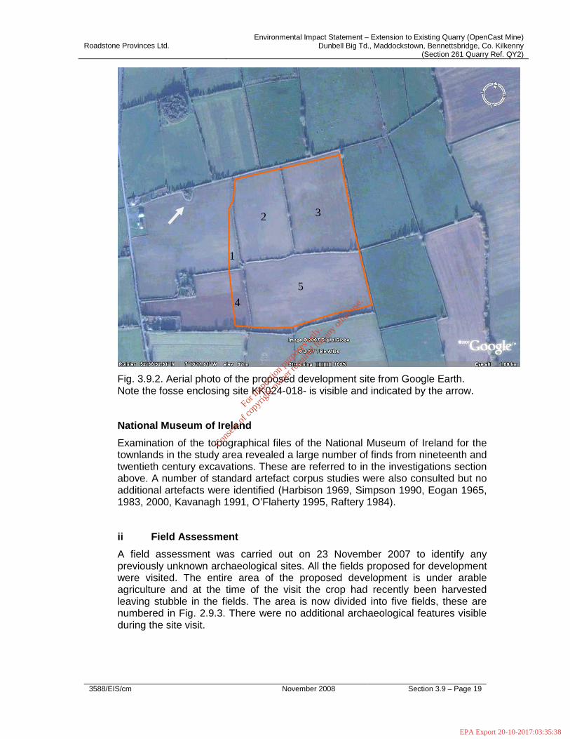
Fig. 3.9.2. Aerial photo of the proposed development site from Google Earth. Note the fosse enclosing site KK024-018- is visible and indicated by the arrow.
National Museum of Ireland
Examination of the topographical files of the National Museum of Ireland for the townlands in the study area revealed a large number of finds from nineteenth and twentieth century excavations. These are referred to in the investigations section above. A number of standard artefact corpus studies were also consulted but no additional artefacts were identified (Harbison 1969, Simpson 1990, Eogan 1965, 1983, 2000, Kavanagh 1991, O’Flaherty 1995, Raftery 1984).
ii Field Assessment
A field assessment was carried out on 23 November 2007 to identify any previously unknown archaeological sites. All the fields proposed for development were visited. The entire area of the proposed development is under arable agriculture and at the time of the visit the crop had recently been harvested leaving stubble in the fields. The area is now divided into five fields, these are numbered in Fig. 2.9.3. There were no additional archaeological features visible during the site visit.
1
2 3
4
5
For
insp
ectio
n pur
pose
s only
.
Conse
nt of
copy
right
owne
r req
uired
for a
ny ot
her u
se.
EPA Export 20-10-2017:03:35:38

Roadstone Provinces Ltd. Environmental Impact Statement – Extension to Existing Quarry (OpenCast Mine)
Dunbell Big Td., Maddockstown, Bennettsbridge, Co. Kilkenny (Section 261 Quarry Ref. QY2)
3588/EIS/cm November 2008 Section 3.9 – Page 20
Fig. 3.9.3. General view of the proposed development area looking north-west.
Fig. 3.9.4. View of site KK024-018- looking north.
For
insp
ectio
n pur
pose
s only
.
Conse
nt of
copy
right
owne
r req
uired
for a
ny ot
her u
se.
EPA Export 20-10-2017:03:35:38

Roadstone Provinces Ltd. Environmental Impact Statement – Extension to Existing Quarry (OpenCast Mine)
Dunbell Big Td., Maddockstown, Bennettsbridge, Co. Kilkenny (Section 261 Quarry Ref. QY2)
3588/EIS/cm November 2008 Section 3.9 – Page 21
Conclusion
There is evidence of prehistoric ritual and settlement activity in the study area. Early Medieval settlement is indicated by the presence of enclosures and ringforts. A number of these have been excavated and large numbers of artefacts and settlement material recovered. By the twelfth century the development area had become part of the lands belonging to Jerpoint Abbey and remained part of the Abbey until its dissolution in 1540 when they were granted to the Earl of Ormond.
3.9.6. ASSESSMENT OF POTENTIAL IMPACTS
i Direct Impacts
There will be no direct impacts on any known archaeological sites or features or items of heritage interest.
ii Indirect Impacts
The closest known monument to the proposed development a ringfort, KK024-018-; see Fig. 3.9.4) has been mostly levelled by agricultural activity and will not be adversely impacted by the proposed development. Note that out of 10 sites noted in Dunbell Big townland in the Record Of Monuments and Places only two (KK024-011- and KK024-016-) remain upstanding and one (KK024-016-) is partly upstanding.
Therefore, there will be no direct impacts on any known archaeological sites or features or items of heritage interest outside the development area.
iii Interaction with Other Impacts
None were identified during the assessment.
iv ‘Do Nothing Scenario’
If the proposed development were not to proceed there would be no negative impact on the cultural heritage.
v ‘Worst Case’ Impact
In the worst case scenario, the development might disturb previously unknown deposits or artefacts without preservation by record taking place.
For
insp
ectio
n pur
pose
s only
.
Conse
nt of
copy
right
owne
r req
uired
for a
ny ot
her u
se.
EPA Export 20-10-2017:03:35:38
Roadstone Provinces Ltd. Environmental Impact Statement – Extension to Existing Quarry (OpenCast Mine)
Dunbell Big Td., Maddockstown, Bennettsbridge, Co. Kilkenny (Section 261 Quarry Ref. QY2)
3588/EIS/cm November 2008 Section 3.9 – Page 22
3.9.7. RECOMMENDATIONS
i Direct Impacts
Due to the possibility of the survival of sub-surface archaeological deposits or finds within the development area, it is recommended that topsoil stripping within the development area be archaeologically monitored.
ii Indirect Impacts
No indirect impacts warranting specific mitigation were identified during the course of the cultural heritage assessment.
For
insp
ectio
n pur
pose
s only
.
Conse
nt of
copy
right
owne
r req
uired
for a
ny ot
her u
se.
EPA Export 20-10-2017:03:35:38

Roadstone Provinces Ltd. Environmental Impact Statement – Extension to Existing Quarry (OpenCast Mine)
Dunbell Big Td., Maddockstown, Bennettsbridge, Co. Kilkenny (Section 261 Quarry Ref. QY2)
3588/EIS/cm November 2008 Section 3.9 – Page 23
3.9.8. Bibliography
Barry, E. 1895. On Ogham-stones seen in Kilkenny County, JRSAI 25, 348-68.
Barry, T. 1987. The Archaeology of Medieval Ireland. London.
Brash, R.R. 1872-3. The Dunbell Ogham inscriptions. JRSAI 12, 238-46.
Cassidy, B. 1991. Digging at Dunbell. Archaeology Ireland 5, 2, 18-20.
Corrigan, W.1905. The History and Antiquities of the Diocese of Ossory. Kilkenny.
Curtis, E. 1932-43. Calendar of Ormond Deeds 1172-1603. Dublin. VI Volumes.
DAHGI 1996. Recorded Monuments Protected under Section 12 of the National Monuments (Amendment) Act, 1994. County Kilkenny
DAHGI 2002. Code of Practice between the Irish Concrete Federation & the Minister for Arts, Heritage, Gaeltacht and the Islands.
Duffy S. et al. 1997. Atlas of Irish History. Dublin.
Ellis, S. G. 1988. Ireland in the Age of the Tudors 1447-1603. London.
Eogan, G. 1965. Catalogue of Irish Bronze Swords. Dublin.
Eogan, G. 1983. Hoards of the Irish Later Bronze Age. Dublin.
Eogan, G. 2000. The Socketed Bronze Axes in Ireland. Prähistorische Bronzefunde, abteilung IX, band 22.
EPA 2002. Guidelines on the information to be contained in Environmental Impact Statements.
For
insp
ectio
n pur
pose
s only
.
Conse
nt of
copy
right
owne
r req
uired
for a
ny ot
her u
se.
EPA Export 20-10-2017:03:35:38
Roadstone Provinces Ltd. Environmental Impact Statement – Extension to Existing Quarry (OpenCast Mine)
Dunbell Big Td., Maddockstown, Bennettsbridge, Co. Kilkenny (Section 261 Quarry Ref. QY2)
3588/EIS/cm November 2008 Section 3.9 – Page 24
EPA 2003. Advice Notes on Current Practice (in the preparation of Environmental Impact Statements)
Ferguson, Samuel 1872-3. (with some introductory observations by John G.A. Prim): The Ogham monuments of Kilkenny (letter), 222-238. JRSAI 12
Flanagan, M.T. 2005. Irish Royal Charters: Texts and Contexts. Oxford.
Gardiner, M.J. and Radford, T. 1980. Soil Associations of Ireland and Their Land Use Potential .Soil Survey Bulletin No. 36. Dublin. An Foras Taluntais.
Heritage Council 1999. The role of the Heritage Council in the Planning Process. Kilkenny.
Joyce, P.W. Irish Local Names Explained. Dublin.
Kavanagh, R.M. 1991. “A reconsideration of razors in the Irish earlier Bronze Age”. Journal of the Royal Society of Antiquaries 121, 77-104.
Kilkenny County Council 2002. County Development Plan 2002-8
Leask, H. 1939.
MacNiocaill, G. 1980 Crown Surveys 1540-41. Dublin. Irish manuscripts Commission.
McConnell, B. and Gatley, S. 2006. Bedrock Geological map of Ireland. Dublin.
Morrin 1862 Patent rolls.
O’Donovan, J. Letters Containing information relative to the Antiquities of the County of Kilkenny Collected during the progress of the Ordnance Survey in 1838
O’Flaherty, R. 1995. “An analysis of Irish Early Bronze Hoards containing copper or bronze objects.” Journal of the Royal Society of Antiquaries 125, 10-45.
O’Riordain, B and Waddell J. 1993. The Funerary Bowls and vases of the Irish Bronze Age. Galway.
For
insp
ectio
n pur
pose
s only
.
Conse
nt of
copy
right
owne
r req
uired
for a
ny ot
her u
se.
EPA Export 20-10-2017:03:35:38
Roadstone Provinces Ltd. Environmental Impact Statement – Extension to Existing Quarry (OpenCast Mine)
Dunbell Big Td., Maddockstown, Bennettsbridge, Co. Kilkenny (Section 261 Quarry Ref. QY2)
3588/EIS/cm November 2008 Section 3.9 – Page 25
Orpen, G.H. 1911-20. Ireland under the Normans. 4 Vols. Oxford.
Otway-Ruthven, A.J. 1980. A History of Medieval Ireland. London.
Prim, John G.A. 1852-1853. Notes on the excavation of a Rath at Dunbel, County of Kilkenny, JRSAI II, 119-127.
Prim, John G.A. 1854-1855. On the discovery of Ogham Monuments and other antiquities in the Raths of Dunbel, County of Kilkenny, JRSAI III ,397-408.
Prim, J.G.A. 1860-61. Donated several antiquities, excavated at Dunbel Rath, discovered in trenching the small Rath lying south of the great Rath of Dunbel (note), JRSAI VI , 307-308.
Prim, J.G.A. 1872-3. The Ogham monuments of Kilkenny being a letter from Samuel Ferguson. JRSAI 12, 222-238.
Graves, J. 1860-61.: A bronze tag of a book-strap, from Dunbel, JRSAI VI, 308.
White, M. 1860-61. Donation of silver penny of Edward I, Dunbel, JRSAI VI, 347.
Raftery, B. 1984. La Tene in Ireland. Marburg.
Simpson, D.D.A. 1990. “The Stone Battle Axes of Ireland.” Journal of the Royal Society of Antiquaries 120, 5-40.
Sweetman, H.S. 1875. Calendar of Documents Relating to Ireland Present in her majesty’s Public Record Office, London, 1171-1251. London
Sweetman, H.S. 1877. Calendar of Documents Relating to Ireland Present in her majesty’s Public Record Office, London, 1252-1284. London
Sweetman, H.S. 1879. Calendar of Documents Relating to Ireland Present in her majesty’s Public Record Office, London, 1285-1292. London.
Sweetman, H.S. 1886. Calendar of Documents Relating to Ireland Present in her majesty’s Public Record Office, London, 1293-1305. London.
For
insp
ectio
n pur
pose
s only
.
Conse
nt of
copy
right
owne
r req
uired
for a
ny ot
her u
se.
EPA Export 20-10-2017:03:35:38
Roadstone Provinces Ltd. Environmental Impact Statement – Extension to Existing Quarry (OpenCast Mine)
Dunbell Big Td., Maddockstown, Bennettsbridge, Co. Kilkenny (Section 261 Quarry Ref. QY2)
3588/EIS/cm November 2008 Section 3.9 – Page 26
Topographical Files, Co. Kilkenny. National Museum of Ireland.
Sweetman, D. 1999. The Medieval Castles of Ireland. Dublin.
Waddell, J. 1990. The Bronze Age burials of Ireland. Galway
Waddell, J. 1998. The Prehistoric Archaeology of Ireland. Galway.
Williams, W. 1857. Ogham readings-with the account of an Ogham monument recently discovered in the ruins of the church of Kilrush near Dungarvan in the Co. of Waterford. JRSAI 4, 334-5.
White, N.B. 1943. Extents of the Irish Monastic Possessions. Dublin.
For
insp
ectio
n pur
pose
s only
.
Conse
nt of
copy
right
owne
r req
uired
for a
ny ot
her u
se.
EPA Export 20-10-2017:03:35:38

Roadstone Provinces Ltd. Environmental Impact Statement – Extension to Existing Quarry (OpenCast Mine)
Dunbell Big Td., Maddockstown, Bennettsbridge, Co. Kilkenny (Section 261 Quarry Ref. QY2)
3588/EIS/cm November 2008 Section 3.9 – Page 27
APPENDIX 3.9.1
SITES ENTERED IN THE RECORD OF MONUMENTS AND PLACES
For
insp
ectio
n pur
pose
s only
.
Conse
nt of
copy
right
owne
r req
uired
for a
ny ot
her u
se.
EPA Export 20-10-2017:03:35:38
Roadstone Provinces Ltd. Environmental Impact Statement – Extension to Existing Quarry (OpenCast Mine)
Dunbell Big Td., Maddockstown, Bennettsbridge, Co. Kilkenny (Section 261 Quarry Ref. QY2)
3588/EIS/cm November 2008 Section 3.9 – Page 28
Appendix 3.9.1
Sites entered in the Record of Monuments and Places
KK024-003--- Dunbell Big Enclosure Site
Indicated on Os 1st ed. Map. Site not visible at ground level.
KK024-01001- Dunbell Big Enclosure Site
Indicated on Os 1st ed. Map. This ringfort was investigated by Prim in 1852 and 1854 and produced large numbers of finds as well as a possible souterrain and two Ogham stones. The site was later investigated by Cassidy in 199-91. The site no longer exists.
KK024-01003- Dunbell Big Ogham Stone
Ogham stone found in a ringfort. The inscription reads:
BRAN(I)TTOS MAQI DECAR(I) DD(ALOS)
KK024-01004- Dunbell Big Ogham Stone
Ogham stone found in a ringfort. The inscription reads:
NAFFALLO AFFI GENITTAC(CI)
KK024-011--- Dunbell Big Ringfort
Indicated on Os 1st ed. Map. Prim (1852-3, 120) noted that this site was trenched in May of 1842. The site is upstanding.
KK024-012--- Dunbell Big Enclosure Site
Not Indicated on Os 1st ed. Map Prim (1852-3, 120) noted that a ringfort in this location was leveled in the early nineteenth century. The site no longer exists.
KK024-01301- Dunbell Big Enclosure Site
Not Indicated on Os 1st ed. Map One of two conjoined rectangular cropmarks visible on air photo CUCAP 1971 BGG 93. Not visible at ground level.
KK024-01302- Dunbell Big Enclosure Site
For
insp
ectio
n pur
pose
s only
.
Conse
nt of
copy
right
owne
r req
uired
for a
ny ot
her u
se.
EPA Export 20-10-2017:03:35:38
Roadstone Provinces Ltd. Environmental Impact Statement – Extension to Existing Quarry (OpenCast Mine)
Dunbell Big Td., Maddockstown, Bennettsbridge, Co. Kilkenny (Section 261 Quarry Ref. QY2)
3588/EIS/cm November 2008 Section 3.9 – Page 29
Not Indicated on Os 1st ed. Map One of two conjoined rectangular cropmarks visible on air photo CUCAP 1971 BGG 93. Not visible at ground level.
KK024-014--- Dunbell Big Ringfort
Indicated on Os 1st ed. Map Leveled Ringfort excavated by C. Foley in 1972. The site no longer exists.
KK024-015--- Dunbell Big Enclosure Site
Not Indicated on Os 1st ed. Map Prim (1872-3, 224) noted a ringfort in this location in 1872 stating that it was nearly obliterated. Not visible at ground level.
KK024-016--- Dunbell Big Ringfort
Indicated on Os 1st ed. Map. Large ringfort. The site is upstanding.
KK024-017--- Dunbell Big Enclosure Site
Not Indicated on Os 1st ed. Map Enclosure site noted as a cropmark on air photos (CUCAP 1971 BGG 94). A sub-circular area with a circular annex at east. Not visible at ground level.
KK024-018--- Dunbell Big Enclosure Site
Site noted on OS 1st ed. Map. Now survives as an oval raised area close to a field boundary.
KK024-019--- Dunbell Big Enclosure Site
Site noted on OS 1st ed. Map. Not visible at ground level.
KK024-02001- Holdenstown Church Site
There is a local tradition of a church and graveyard in this location. The site is not indicated on any edition of the OS maps. Any remains of the site were removed during land reclamation in 1959. Not visible at ground level.
KK024-02002- Holdenstown Graveyard
There is a local tradition of a church and graveyard in this location. The site is not indicated on any edition of the OS maps. Any remains of the site were removed during land reclamation in 1959. Not visible at ground level.
KK024-029--- Sheastown Enclosure Site
For
insp
ectio
n pur
pose
s only
.
Conse
nt of
copy
right
owne
r req
uired
for a
ny ot
her u
se.
EPA Export 20-10-2017:03:35:38

Roadstone Provinces Ltd. Environmental Impact Statement – Extension to Existing Quarry (OpenCast Mine)
Dunbell Big Td., Maddockstown, Bennettsbridge, Co. Kilkenny (Section 261 Quarry Ref. QY2)
3588/EIS/cm November 2008 Section 3.9 – Page 30
Not Indicated on Os 1st ed. Map Small circular cropmark visible on air photo CUCAP 1969 AYK66.
KK024-030--- Sheastown Burial (s)
Not Indicated on Os 1st ed. Map 10 adult burials associated with an iron knife were found at this location in 1974.
KK024-03101- Bennettsbridge Church
Indicated on Os 1st ed. Map This was the site of the parish church which was demolished in 1795 by Colonel John Shee who built a C of I church which was in turn demolished in 1960. The site has a graveyard.
KK024-03102- Bennettsbridge Graveyard
KK024-035--- Ballyredding North Enclosure Site
Not Indicated on Os 1st ed. Map Circular cropmark visible on CUCAP 1967 ATA 13.
KK024-037--- Bishopslough West Fulacht Fiadh Site
Not Indicated on Os 1st ed. Map. Possible ploughed over fulacht fiadh reported by C. Manning of OPW.
KK024-038--- Bishopslough West Fulacht Fiadh Site
Not Indicated on Os 1st ed. Map. Possible ploughed over fulacht fiadh reported by C. Manning of OPW.
For in
spec
tion p
urpo
ses o
nly.
Conse
nt of
copy
right
owne
r req
uired
for a
ny ot
her u
se.
EPA Export 20-10-2017:03:35:39