section 2: salt marshes - university of miami · pdf filesalt marshes are coastal wetlands...
TRANSCRIPT

1
Marine Conservation Science and Policy Service learning Program
Salt marshes are coastal wetlands rich in marine life. They are sometimes called tidal
marshes, because they occur in the zone between low and high tides. Salt marsh plants cannot grow where waves are strong, but they thrive along low-energy coasts. They also occur in areas called estuaries, where freshwater from the land mixes with sea water. A distinctive feature of salt marshes is the color - the plants are various shades of gray, brown, and green.
Module 1: Ocean and Coastal Habitats
Sunshine State Standards SC.912.N.1.1, SC.912.N.1.4, SC.912.E.7.4, SC.912.L.14.3, SC.912.L.14.7, SC.912.L.14.8, SC.912.L.14.10, SC.912.L.15.2, SC.912.L.15.13
Objectives
Learn and understand the importance of salt marshes
Name several salt marsh functions
Recognize the relationship between natural and developed areas and the impact human activities have on those areas;
Understand watershed concepts by observing what happens to an aquatic area during a rain event;
Draw conclusions about what they can do to help reduce, reuse and recycle products in every day use
Section 2: Salt Marshes
2
Vocabulary Brackish water- is water that has more salinity than fresh water, but not as much as seawater. It may result from mixing of seawater with fresh water, as in estuaries, or it may occur in brackish fossil aquifers.
Coast- is defined as where the land meets the sea. A precise line that can be called a coastline cannot be determined due to the dynamic nature of tides. The term "coastal zone" can be used instead, which is a spatial zone where interaction of the sea and land processes occurs Halophyte- is a plant that naturally grows where it is affected by salinity in the root area or by salt spray, such as in saline semi-deserts, mangrove swamps, marshes and sloughs, and seashores.
Intertidal zone- (also known as the foreshore and seashore and sometimes referred to as the littoral zone) is the area that is exposed to the air at low tide and underwater at high tide (for example, the area between tide marks).
Marsh - is a type of wetland that is subject to frequent or continuous flood. Typically the water is shallow and features grasses, rushes, reeds, typhas, sedges, and other herbaceous plants. Woody plants will be low-growing shrubs. A marsh is different from a swamp, which has a greater proportion of open water surface and may be deeper than a marsh. In North America, the term "swamp" is used for wetland dominated by trees rather than grasses and low herbs.
Background
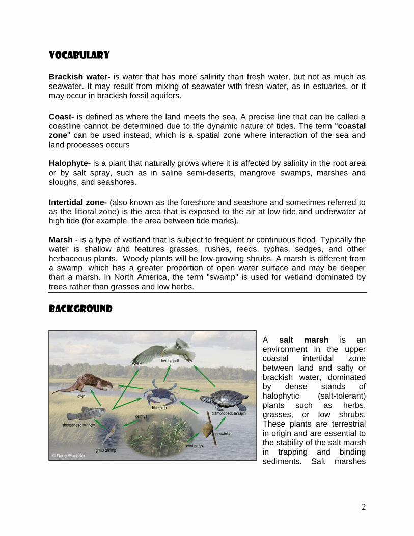
A salt marsh is an environment in the upper coastal intertidal zone between land and salty or brackish water, dominated by dense stands of halophytic (salt-tolerant) plants such as herbs, grasses, or low shrubs. These plants are terrestrial in origin and are essential to the stability of the salt marsh in trapping and binding sediments. Salt marshes

3
play a large role in the aquatic food web and the exporting of nutrients to coastal waters. They also provide support to terrestrial animals such as migrating birds as well as providing coastal protection.
Location
Salt marshes occur on low-energy coasts in temperate and high-latitudes. These typically include sheltered environments such as embankments, estuaries and the leeward side of barrier islands and spits. In the tropics and sub-tropics they are replaced by mangroves; an area that differs to a salt marsh in that instead of herbaceous plants, they are dominated by salt-tolerant trees. Most salt marshes have a low topography with low elevations but a vast wide area, making them hugely popular for human populations.
4
Salt marshes are located among different landforms based on their physical and geomorphological settings. Such marsh landforms include deltaic marshes, estuarine, back-barrier, open coast, embayments and drowned-valley marshes. Deltaic marshes are associated with large rivers where many occur in Southern Europe such as the Camargue in the Rhone delta or the Ebro delta. They are also highly extensive within the rivers of the Mississippi Delta. In New Zealand, most salt marshes occur at the head of estuariesin areas where there is little wave action and high sedimentation. Such marshes are located in Awhitu Regional Park in Auckland, the Manawatu Estuary and the Avon-Heathcote Estuary in Christchurch. Back-barrier marshes are sensitive to the reshaping of barriers in the landward side of which they have been formed. They are common along much of the eastern coast of the United States and the Frisian Islands. Large, shallow coastal embayments can hold salt marshes with examples including Morecambe Bay and Portsmouth in Britain and the Bay of Fundy in North America.
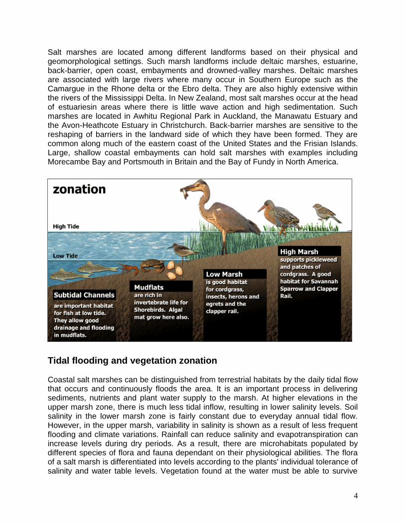
Tidal flooding and vegetation zonation
Coastal salt marshes can be distinguished from terrestrial habitats by the daily tidal flow that occurs and continuously floods the area. It is an important process in delivering sediments, nutrients and plant water supply to the marsh. At higher elevations in the upper marsh zone, there is much less tidal inflow, resulting in lower salinity levels. Soil salinity in the lower marsh zone is fairly constant due to everyday annual tidal flow. However, in the upper marsh, variability in salinity is shown as a result of less frequent flooding and climate variations. Rainfall can reduce salinity and evapotranspiration can increase levels during dry periods. As a result, there are microhabitats populated by different species of flora and fauna dependant on their physiological abilities. The flora of a salt marsh is differentiated into levels according to the plants' individual tolerance of salinity and water table levels. Vegetation found at the water must be able to survive
5
high salt concentrations, periodical submersion, and a certain amount of water movement, while plants further inland in the marsh can sometimes experience dry, low-nutrient conditions. It has been found that the upper marsh zones limit species through competition and the lack of habitat protection, while lower marsh zones are determined through the ability of plants to tolerate physiological stresses such as salinity, water submergence and low oxygen levels.
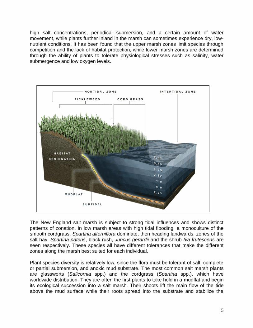
The New England salt marsh is subject to strong tidal influences and shows distinct patterns of zonation. In low marsh areas with high tidal flooding, a monoculture of the smooth cordgrass, Spartina alterniflora dominate, then heading landwards, zones of the salt hay, Spartina patens, black rush, Juncus gerardii and the shrub Iva frutescens are seen respectively. These species all have different tolerances that make the different zones along the marsh best suited for each individual.
Plant species diversity is relatively low, since the flora must be tolerant of salt, complete or partial submersion, and anoxic mud substrate. The most common salt marsh plants are glassworts (Salicornia spp.) and the cordgrass (Spartina spp.), which have worldwide distribution. They are often the first plants to take hold in a mudflat and begin its ecological succession into a salt marsh. Their shoots lift the main flow of the tide above the mud surface while their roots spread into the substrate and stabilize the

6
sticky mud and carry oxygen into it so that other plants can establish themselves as well. Plants such as sea lavenders (Limonium spp.), plantains (Plantago spp.), and varied sedges and rushes grow once the mud has been vegetated by the pioneer species.
Salt marshes are quite photosynthetically active and are extremely productive habitats. They serve as depositories for a large amount of organic matter and are full of decomposition, which feeds a broad food chain of organisms from bacteria to mammals. Many of the halophytic plants such as cordgrass are not grazed at all by higher animals but die off and decompose to become food for micro-organisms, which in turn become food for fish and birds.
Human impacts
The coast is a highly attractive natural feature to humans through its beauty, resources, and accessibility. As of 2002, over half of the world‟s population was estimated to being living within 60km of the coastal shoreline, making our coastlines highly vulnerable to human impacts from daily activities that put pressure on these surrounding natural environments. In the past, salt marshes were perceived as coastal „wastelands,‟ causing
considerable loss and change of these ecosystems through land reclamation for agriculture, urban development, salt production and recreation. The indirect effects of human activities such as nitrogen loading also play a major role in the salt marsh area.
7
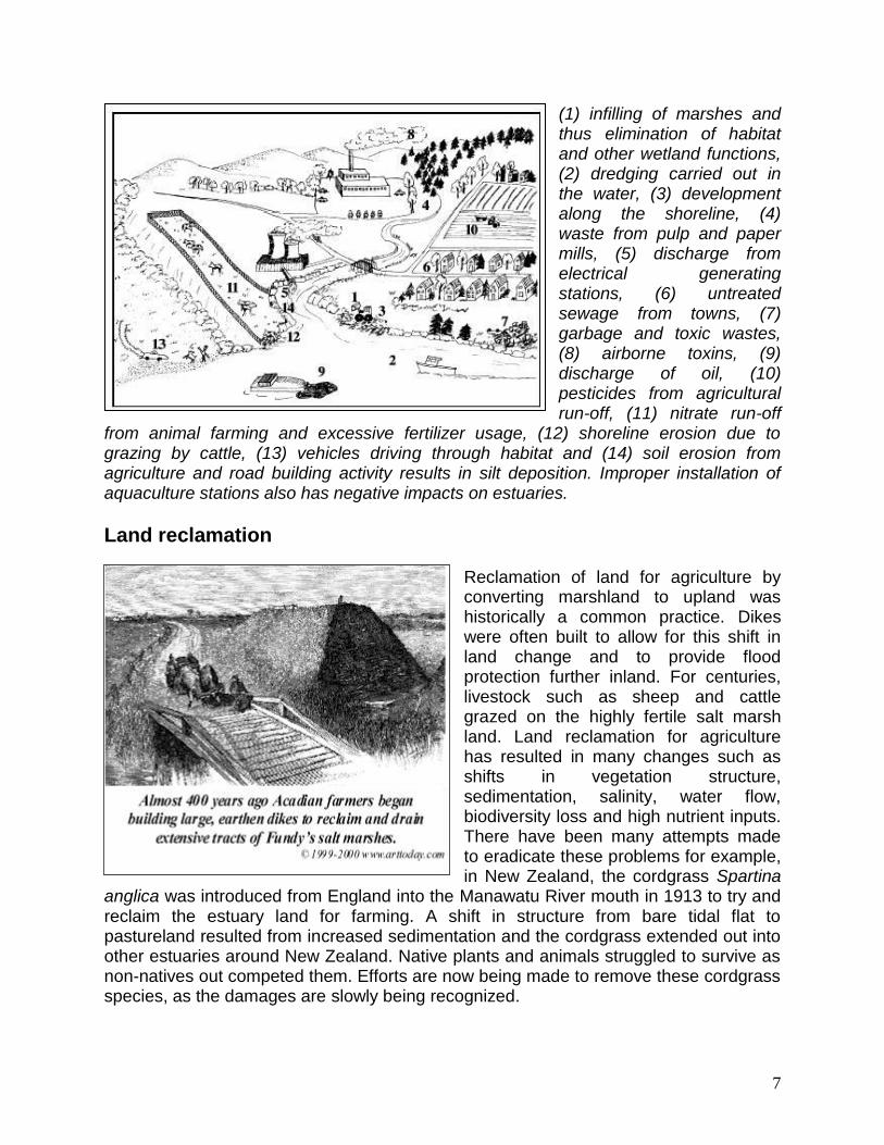
(1) infilling of marshes and thus elimination of habitat and other wetland functions, (2) dredging carried out in the water, (3) development along the shoreline, (4) waste from pulp and paper mills, (5) discharge from electrical generating stations, (6) untreated sewage from towns, (7) garbage and toxic wastes, (8) airborne toxins, (9) discharge of oil, (10) pesticides from agricultural run-off, (11) nitrate run-off
from animal farming and excessive fertilizer usage, (12) shoreline erosion due to grazing by cattle, (13) vehicles driving through habitat and (14) soil erosion from agriculture and road building activity results in silt deposition. Improper installation of aquaculture stations also has negative impacts on estuaries.
Land reclamation
Reclamation of land for agriculture by converting marshland to upland was historically a common practice. Dikes were often built to allow for this shift in land change and to provide flood protection further inland. For centuries, livestock such as sheep and cattle grazed on the highly fertile salt marsh land. Land reclamation for agriculture has resulted in many changes such as shifts in vegetation structure, sedimentation, salinity, water flow, biodiversity loss and high nutrient inputs. There have been many attempts made to eradicate these problems for example, in New Zealand, the cordgrass Spartina
anglica was introduced from England into the Manawatu River mouth in 1913 to try and reclaim the estuary land for farming. A shift in structure from bare tidal flat to pastureland resulted from increased sedimentation and the cordgrass extended out into other estuaries around New Zealand. Native plants and animals struggled to survive as non-natives out competed them. Efforts are now being made to remove these cordgrass species, as the damages are slowly being recognized.

8
Nitrogen loading
Following the period of marshland conversion for agriculture, these areas were later transformed into urban, residential and industrial land. Major cities such as Boston, San Francisco, Amsterdam, Rotterdam, Venice and Tokyo have all expanded out into areas of salt marsh. The remaining marshes surrounding these urban areas are under immense pressure from the human population as human-induced nitrogen enrichment enters these habitats.
Nitrogen loading through human-use indirectly affects salt marshes causing
shifts in vegetation structure and the invasion of non-native species. Human impacts such as sewage, urban run-off, agricultural and industrial wastes are running into the marshes from nearby sources. Salt marshes are nitrogen limited and with an increasing level of nutrients entering the system from anthropogenic effects, the plant species

9
associated with salt marshes are being restructured through change in competition. For example, the New England salt marsh is experiencing a shift in vegetation structure where S. alterniflora is spreading from the lower marsh where it predominately resides up into the upper marsh zone. Additionally, in the same marshes, the reed Phragmites australis has been invading the area expanding to lower marshes and becoming a dominant species. P. australis is an aggressive halophyte that can invade disturbed areas in large numbers outcompeting native plants. This loss in biodiversity is not only seen in flora assemblages but also in many animals such as insects and birds as their habitat and food resources are altered.
Restoration and management
The perception of bay salt marshes as a coastal „wasteland‟ has since changed, acknowledging that they are one of the most biologically productive habitats on earth, rivalling tropical rainforests. Salt marshes are ecologically important providing habitats for native migratory fish and acting as sheltered feeding and nursery grounds. They are now protected by legislation in many countries to look after these ecologically important habitats. In the United States and Europe, they are now accorded to a high level of protection by the Clean Water Act and the Habitats Directive respectively. With the impacts of this habitat and its importance now realized, a growing interest in restoring salt marshes, through managed retreat or the reclamation of land has been established. However, many

10
Asian countries such as China are still to recognize the value of marshlands. With their ever-growing populations and intense development along the coast, the value of salt marshes tends to be ignored and the land continues to be reclaimed.
Bakker et al. (1997) suggests two options available for restoring salt marshes. The first is to abandon all human interference and leave the salt marsh to complete its natural development. These types of restoration projects are often unsuccessful as vegetation tends to struggle to revert back to its original structure and the natural tidal cycles are shifted due to land changes. The second option suggested by Bakker et al. (1997) is to restore the destroyed habitat into its natural state either at the original site or as a replacement at a different site. Under natural conditions, recovery can take 2-10 years or even longer depending on the nature and degree of the disturbance and the relative maturity of the marsh involved. Marshes in their pioneer stages of development will recover more rapidly than mature marshes as they are often first to colonize the land. It is important to note, that restoration can often be sped up through the replanting of native vegetation.

11
While humans are situated along coastlines, there will always be the possibility of human-induced disturbances despite the number of restoration efforts we plan to implement. Dredging, pipelines for offshore petroleum resources, highway construction, accidental toxic spills or just plain carelessness are examples that will for some time now and into the future be the major influences of salt marsh degradation.
In addition to restoring and managing salt marsh systems based on scientific principles, the opportunity should be taken to educate public audiences of their importance biologically and their purpose as serving as a natural buffer for flood protection. Because salt marshes are often located next to urban areas, they are likely to receive more visitors than remote wetlands. By physically seeing the marsh, people are more likely to
take notice and be more aware of the environment around them. An example of public involvement occurred at the Famosa Slough wetland in San Diego, where a “friends” group worked for over a decade in trying to prevent the area from being developed. Eventually after much convincing, the 5 hectare site was bought by the City and the group worked together to restore the area. The project involved removing invasive species and replanting with natives, along with public talks to other locals, frequent bird walks and clean-up events. This example shows that restoration projects do not always need to come from governments, scientists or those higher up, but with the initiative of a few, we can start to restore and claim back our valuable and productive salt marshes.
Florida Salt Marshes
Salt marshes are composed of a variety of plants: rushes, sedges, and grasses. Florida's dominant salt marsh species include: black needle rush (Juncus roemerianus), the grayish rush occurring along higher marsh areas; saltmeadow cord grass (Spartina patens), growing in areas that are periodically inundated; smooth cord grass (Spartina alterniflora), found in the lowest areas that are most frequently inundated; and sawgrass (Cladium jamaicense), which is actually a freshwater plant

12
that sometimes grows along the upper edges of salt marshes. All are tolerant of the salt in sea spray.
Salt marshes are important for many reasons. Hidden within the tangle of salt marsh plants are animals in various stages of life. Animals can hide from predators in marsh vegetation, because the shallow brackish area physically excludes larger fish. Many of Florida's popular marine fisheries species spend the early part of their lives protected in salt marshes.
Young fish often have a varied diet, foraging for food in the muds of the marsh bottom, on the plants themselves, and on smaller organisms that also dwell in the marsh system. As salt marsh plants die and decompose, they create organic detritus, another food source for many marsh dwellers. Tidal waters move up into the marsh and then retreat, distributing detritus throughout the estuary. Algae are also an important food source in salt marshes.
Salt marshes form along the margins of many north Florida estuaries. Gulf coast salt marshes occur along low energy shorelines, at the mouth of rivers, and in bays, bayous, and sounds. The Panhandle region west of Apalachicola Bay consists mainly of estuaries with few salt marshes. However, from Apalachicola Bay south to Tampa Bay, salt marshes are the main forms of coastal vegetation. The coastal area known as "Big Bend" has the greatest salt marsh acreage in Florida, extending from Apalachicola Bay to Cedar Key. South of Cedar Key salt marshes begin to be replaced by mangroves as the predominant intertidal plants. On the Atlantic coast, salt marshes occur from Daytona Beach northward.
Despite their value, salt marshes are too often considered to be worthless. Salt marshes provide nursery areas for fishes, shellfish, and crustaceans. These plants have extensive root systems which enable them to withstand brief storm surges, buffering the impact on upland areas. Salt marshes also act as filters. Tidal creeks

13
meander through the marshes transporting valuable nutrients as well as pollutants from upland development. Salt marshes can absorb, or trap, some of these pollutants, reducing the pollutant load entering estuaries. Salt marshes also prevent sediments from washing offshore, often creating more land on which salt marshes can grow.
Salt Marsh Losses in Florida
Salt marsh systems are dynamic, constantly changing. Society, however, emphasizes stability and permanence. As a result, salt marshes have been drained or filled with silt, sand, or refuse to an elevation at which they can no longer survive. It is estimated that in Florida at least 60,000 acres, or 8 percent, of estuarine habitat has been lost to permitted dredge and fill activities.
The Florida Marine Research Institute is studying changes in Florida's coastal habitats. Scientists can evaluate changes by comparing aerial photographs of the coast in the 1940's, 1950's, and 1980's. Too frequently, the changes observed show loss of fisheries habitats.
Salt marsh loss has occurred in Florida's five northeast counties, which contain 11 percent of the State's total salt marsh acreage. The primary loss in Nassau County occurred because of dredging for the Intracoastal Waterway. Duval County has been impacted even more severely by human activity. Extending 3.5 miles on either side of St. John's Inlet and 10 miles up the St. John's River, analysis indicated a 36 percent loss of marsh habitat. The loss is primarily due to dredge and fill of marsh habitat since 1943.
In Palm Beach County, a 51 percent decrease in salt marsh acreage occurred in Lake Worth between 1944 and 1982 due to major land developments. A network of canals draining low lying uplands diverted the natural flow of freshwater away from salt marsh areas.
In southwest Florida, both salt marshes and mangroves occur along the Tampa Bay shore. Since 1940, Tampa Bay has been one of the fastest growing metropolitan areas in Florida. Considerable environmental damage has occurred in Tampa Bay along with this growth. Four major types of dredging have impacted Tampa Bay during the last 100 years: channel deepening, maintenance dredging, shell dredging, and dredging for land fill construction. Ship channel dredging and port construction have brought Tampa Bay the economic benefits of being one of the largest ports in the nation. Tampa Bay has lost more than 40 percent of its original mangrove and salt marsh acreage over this time.
The elimination and alteration of Florida salt marshes have a negative effect on fishery resources. Estuaries provide nursery areas for at least 70 percent of Florida's important recreational and commercial fishes, shellfish, and crustaceans. Many of Florida's marine fisheries will decline and may disappear without coastal wetlands.

14
State regulations have been enacted to protect Florida's salt marsh systems. Specifically, the Warren B. Henderson Wetlands Act of 1984 established clear guidelines for defining wetland areas that come under state jurisdiction. All dredging and filling activities in state waters require permits unless specifically exempted. Local laws vary, so be sure to check with officials in your area before taking any action.
15
Salt Marshes Dominant Plants
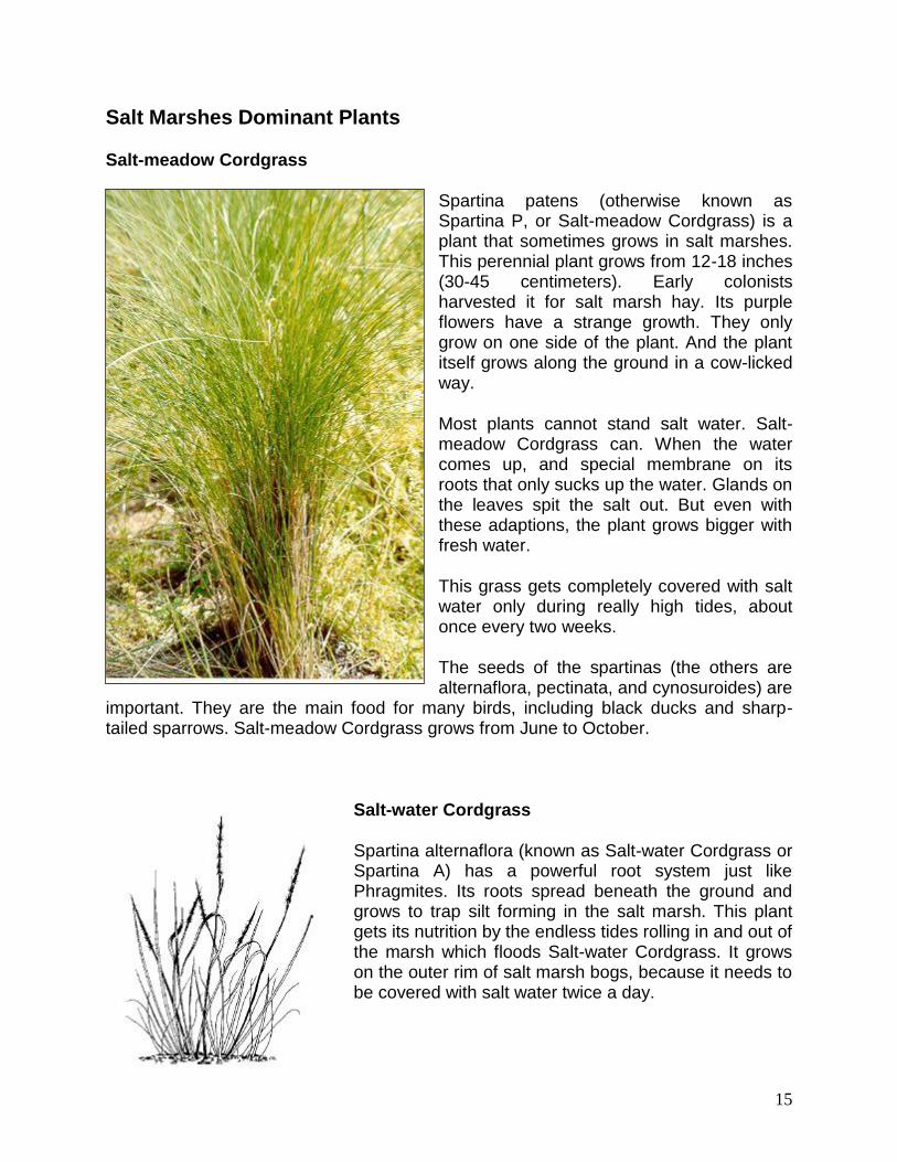
Salt-meadow Cordgrass
Spartina patens (otherwise known as Spartina P, or Salt-meadow Cordgrass) is a plant that sometimes grows in salt marshes. This perennial plant grows from 12-18 inches (30-45 centimeters). Early colonists harvested it for salt marsh hay. Its purple flowers have a strange growth. They only grow on one side of the plant. And the plant itself grows along the ground in a cow-licked way.
Most plants cannot stand salt water. Salt-meadow Cordgrass can. When the water comes up, and special membrane on its roots that only sucks up the water. Glands on the leaves spit the salt out. But even with these adaptions, the plant grows bigger with fresh water.
This grass gets completely covered with salt water only during really high tides, about once every two weeks.
The seeds of the spartinas (the others are alternaflora, pectinata, and cynosuroides) are
important. They are the main food for many birds, including black ducks and sharp-tailed sparrows. Salt-meadow Cordgrass grows from June to October.
Salt-water Cordgrass
Spartina alternaflora (known as Salt-water Cordgrass or Spartina A) has a powerful root system just like Phragmites. Its roots spread beneath the ground and grows to trap silt forming in the salt marsh. This plant gets its nutrition by the endless tides rolling in and out of the marsh which floods Salt-water Cordgrass. It grows on the outer rim of salt marsh bogs, because it needs to be covered with salt water twice a day.
16
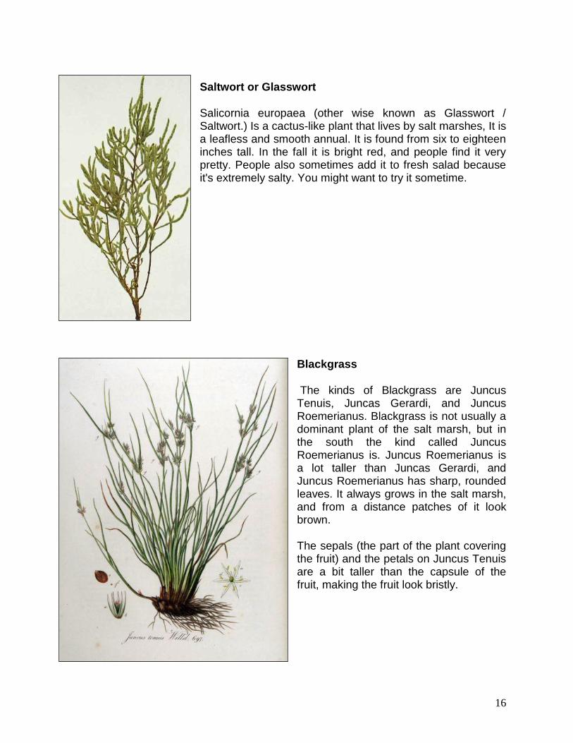
Saltwort or Glasswort
Salicornia europaea (other wise known as Glasswort / Saltwort.) Is a cactus-like plant that lives by salt marshes, It is a leafless and smooth annual. It is found from six to eighteen inches tall. In the fall it is bright red, and people find it very pretty. People also sometimes add it to fresh salad because it's extremely salty. You might want to try it sometime.
Blackgrass
The kinds of Blackgrass are Juncus Tenuis, Juncas Gerardi, and Juncus Roemerianus. Blackgrass is not usually a dominant plant of the salt marsh, but in the south the kind called Juncus Roemerianus is. Juncus Roemerianus is a lot taller than Juncas Gerardi, and Juncus Roemerianus has sharp, rounded leaves. It always grows in the salt marsh, and from a distance patches of it look brown.
The sepals (the part of the plant covering the fruit) and the petals on Juncus Tenuis are a bit taller than the capsule of the fruit, making the fruit look bristly.

17
Goldenrod
Solidago Sempervirens (known as Seaside Goldenrod) is a common salt marsh species often found on the border of salt marshes. This smooth-stemmed planted is in the sunflower family and is 1-3 feet tall. It has yellow flowers, and a tint of purple-red, because of it's purplish pigment. The leaves, not jagged. The flowers grow on its branch-like stems.
Gerardia
The lovely pink blossoms of a Gerardia can be found from mid-July to September amongst such plants as the sea lavender, the arrow grass and the seaside plantain. The fruit found among this plant's narrow leaves look almost like a miniature acorn. Gerardia is related to the golden snap dragon and grows to be no larger than 8 in. tall.
Spikegrass
Spikegrass is a common enough plant to be found, sprinkled in various areas of salt marsh. Spikegrass may also be found in a sturdy line by the water. It has long pale green stems which are how Spikegrass got it's name. Spikegrass, unlike a lot of other salt marsh plants, can with-stand the salt which comes in through

18
the tides. This plant is eaten by the geese living in the midst of the marsh.
Groundsel Tree
Groundsel Tree is a shrub living in the outskirts of the salt marsh. A Groundsel Tree is related to the sunflower and grows to be 3 to 6 f.t. tall. The leaves of a Groundsel Tree are in assortment clustered on the stem and look somewhat like tiny spades. The edges of these leaves are slightly jagged.
Bayberry
I n the summer, Bayberry up until then was green and bare. But, as the seasons change, in the summer, at the tips of the stems where two stems separate, the green berries begin tot take form. By late summer, they have turns a rich blue and has a very fragrant smell. Bayberry is quite often used for candles because of the wonderful scent it gives off and sometimes, insects like the praying mantis nest in its leaves.

19
Phragmites
Phragmites is a fern-like plant living at the outskirts of salt marshes and other moist areas. This rapidly spreading vegetation, with its powerful roots, chokes out all the other plants and takes over. So this plant, with its bright violet flowers and gray fruits, is very common. This plant also had and still has many uses, for instance, phragmites was once used as a pen, as was a feather at the time.
Marsh Elder
Marsh Elder is a bush that grows on the border of high water in the salt marsh. It can be as short as three feet, or as tall as five feet, or, of course, in between. The leaves on the plant grow opposite to each other, and their texture is fleshy and sharp-toothed. Its flowers, which grow in the summer, and greenish-white.

20
Sea Lavender
Sea Lavender blooms in August with a beautiful purple blossom. They're on the endangered species list. They live in the mud, and when people try to pick it the roots come out. It is one of the nicest plants that live on marshlands. It has small cone-shaped flowers, and it is pale purple. They can grow up to one foot or more.
Orach
This vine-like plant with wedge-shaped leaves can be found in the less saline marshes or scattered about saltmeadow cordgrass on the high marsh. We found it right on the border between saltmarsh grasses and phragmites.
21
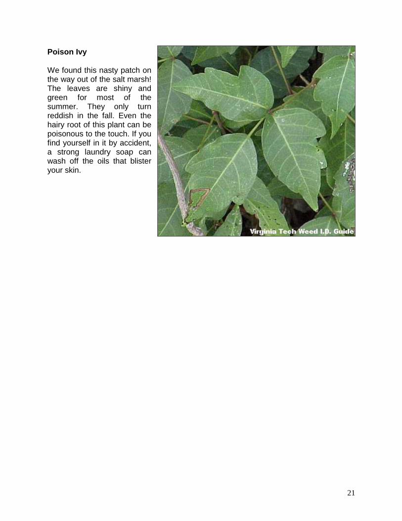
Poison Ivy
We found this nasty patch on the way out of the salt marsh! The leaves are shiny and green for most of the summer. They only turn reddish in the fall. Even the hairy root of this plant can be poisonous to the touch. If you find yourself in it by accident, a strong laundry soap can wash off the oils that blister your skin.

22
Activity: SALT MARSH IN A PAN Duration: 2 hours OVERVIEW
Students create a model of a salt marsh to discover the impact of pollution and human activities on water-based habitats including bays and the ocean. Model may also be used to demonstrate salt marsh functions, non-point source pollution and watershed concepts.
Materials
One paint roller pan, non-hardening modeling clay to fill 1/3 the roller pan,
sponges to fit across the width of the tray (optional),
supplies to make a road, houses, birds
And anything else found in a neighborhood including trees and grasses. To complete demonstration you will need:
Watering can, Green food coloring,
Soy sauce or oil, Bits of paper
Ground coffee, chocolate sprinkles.
Background
Salt marshes help protect our estuaries from the impacts of nature and humans. The special grasses that grow in the marsh can tolerate flooding from salt water. These plants are effective storm buffers because they dissipate wave energy and soak up tidal surges. Salt marsh plants are also a defensive against the erosive power of tides because they have deep roots that hold soil in place. Salt marshes plants and mud also hold and trap pollutants and excess sediment, which helps to improve water quality. When we develop an area along a waterway, effluents such as fertilizers, sewage, and storm drain runoff all enter the water. Left untreated or free-floating in the water, high levels of these nutrients cause eutrophication which causes an initial explosion of algal growth followed by decline in plant life and dissolved oxygen. Plants from the salt marsh help to handle pollutants in several ways. Marshes can take up and filter the pollutants while others settle into the soil strata and are chemically reduced over time. More are processed by bacterial action. When salt marshes are filled or lost, pollutants they could have rendered harmless remain in the water, free to move all over the water system and into the ocean. In addition to the great buffer zone and filtering capacity, the salt marsh is capable of absorbing and holding large quantities of water for use by wildlife in times of drought.

23
PROCEDURE
1. Spend about 5 minutes discussing the causes of water pollution and the possible origins of litter found on the beach, riverbank or salt marsh.
2. Divide students into three groups; Developers, Residents and Rainmakers. 3. The Developers build the model in the roller pan by adding a 1/2” thick layer of
clay to the shallow top third of the pan. 4. This group should build creeks, a river, a storm drain, a road, houses, trees and
plants into their clay terrain. 5. The low end of the tray represents a large body of water, such as the bay or the
ocean. 6. The Residents add pollutants to the landmass built by the Developers by adding
a few drops of food coloring to symbolize fertilizer, bits of paper to symbolize litter, chocolate sprinkles to symbolize pet waste, oil or soy sauce to symbolize motor oil dumped or leaked from automobiles and coffee grounds to represent loose sediment and topsoil which contribute to turbidity.
7. All students then make predictions about what will happen when the model terrain is rained upon.

24
8. After predictions are recorded, the Rainmaker group uses the watering can to make it rain.
9. Students observe where their pollutants went and compare what happened to the model when it rained to their predictions.
10. Pour dirty water into a clear container so students can see just how polluted the rainwater became.
EXTENSIONS Add a salt marsh to the pan by putting damp sponges across the open edge of the clay terrain. Repeat the demonstration. Before rain event, record student predictions about how this demonstration will be different than the first round without the sponges (salt marsh). To demonstrate the ability of a salt marsh to absorb excess water and prevent flooding, use the same, pre-measured amount of water for your “rainstorm” each time (with and without sponges in place). Record predictions and re-measure “polluted” water after each round. Observe changes (less water, less pollution with salt marsh in place).

25

26

27
Activity: Salt Marsh Lesson Plan
Duration: 1 or several class periods
Objectives
Physical parameters of salinity and elevation/depth in a salt marsh will be investigated. These data will be collected along several transects. They will then be graphed, and collated with concurrent studies of dominant plant and animal species, allowing for the identification of biological zones and some physical factors influencing them.
Objectives
Upon completion of these activities, students should be able to:
establish transects in the field use a salinity meter measure elevation above an established point along a transect measure water depth below an established point along a transect plot raw data onto a graph representing a profile identify zonations based on dominant species and physical conditions establish a 5 meter squared grid and map the location of dominant plant species
to identify from season to season
Materials needed
meter sticks metric measuring tapes metal stakes carpenter's level string salinity meter graph paper field guides and taxonomic keys hand lenses dissecting microscopes collecting buckets collecting bags field notebooks
Major concepts
A salt marsh is an area of sediment accumulation and the most productive of all ecosystems in terms of biomass

28
The most important nutrients in a salt marsh come from detritus, the previous year's plant growth
A salt marsh can be understood best when the approach is multidisciplinary Salt marshes are extremely important as they offer breeding grounds and
protected areas for fish and other organisms to develop
Background information
A salt marsh is an area fringing a shoreline that is protected from waves, strong coastal currents and storms sufficiently that sediment can accumulate and support a dense stand of grasses, sedges and other herbaceous plants, as well as the organisms associated with them. The type of plants and other native organisms depends in large part on the latitude, and therefore, the climate, but it
each case conditions must allow for sediment accretion.
A salt marsh offers a unique opportunity for field studies, as it is relatively small, assessible, shallow, and densely populated with organisms. For schools fortunate enough to have a salt marsh nearby, one-day field trips to long-term field studies allow students to improve many skills, including observation, field identification, use of scientific instruments, collection and analysis of data. A salt marsh is an interface not only of land, sea and the atmosphere, but also a site where elements of biology, chemistry, geology, physics, meteorology, and ecology can all be explored.
The salt marsh type in our region is dominated by species of the genus Spartina, also known as saltmarsh cordgrass (S. alterniflora) and saltmeadow cordgrass (S. patens). Two excellent examples are Flax Pond in Old Field, and Caumsett Park on Lloyd Neck.
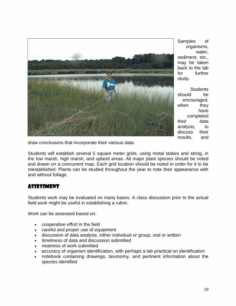
Procedure
Establish 1 or more transects using metal stakes and the metric tape measure. Instruct students to take samples, depth or elevation readings, or whatever variable they are studying at regular intervals, perhaps every 3 meters, and record their data.
29
Samples of organisms,
water, sediment, etc., may be taken back to the lab for further study.
Students should be
encouraged, when they
have completed
their data analysis, to discuss their results, and
draw conclusions that incorporate their various data.
Students will establish several 5 square meter grids, using metal stakes and string, in the low marsh, high marsh, and upland areas. All major plant species should be noted and drawn on a concurrent map. Each grid location should be noted in order for it to be reestablished. Plants can be studied throughout the year to note their appearance with and without foliage.
Assessment
Students work may be evaluated on many bases. A class discussion prior to the actual field work might be useful in establishing a rubric.
Work can be assessed based on:
cooperative effort in the field careful and proper use of equipment discussion of data analysis, either individual or group, oral or written timeliness of data and discussion submitted neatness of work submitted accuracy of organism identification, with perhaps a lab practical on identification notebook containing drawings, taxonomy, and pertinent information about the
species identified

30
For Further Study
The preceding is merely a way of introducing students to the kinds of scientific investigations that a salt marsh affords. An enormous advantage to any field work in Flax Pond is that it has been the site of many studies, from high school to the post-doctoral level. Almost any data collected can therefore be compared with information in the literature. There are many possibilities for long-term work in Flax Pond or some other salt marsh. A partial list is offered below.
1. Select a species, especially a dominant species, of the salt marsh, investigate its life habits in the literature, and study it in the field in order to answer the following questions
What is its role in this ecosystem? producer, consumer, decomposer, predator, prey, etc.?
In what symbiotic relationships is it involved?
What effects on the physical environment does this species have?
How is this species distributed in the marsh?
Does its distribution influence variation in size, form, gender ratios, etc.?
Are there seasonal variations in distribution?
What special adaptations does this species have for its role in the marsh?
2. Take core samples of the marsh using an auger. Is the underlying peat uniform with depth? How thick is it? If there are historical data, how do sedimentation rates differ for different sites? Compare students' results with those in the literature.
3. Make a cross-section of the marsh channel, calculate the cross-sectional area, measure the flow and determine the channel discharge rate.
How does this vary with other cross-sections along the channel?
What happens to flow when the channel widens? Narrows?
How does the flow vary through ebb and flood tides? Lunar phases? Seasons?

31
4. Conduct a study of water chemistry throughout the marsh. Are salinity, dissolved oxygen, and other readings the same everywhere? If not, why not? If not, how do these variations effect the distribution of organisms?
5. Conduct a survey of the plankton micro- and macroorganisms that come into the marsh. Use plankton net for collection. Identify and diagram food webs that involve them. Do these populations vary seasonally? From year to year?
6. Does the marsh support amphibian, reptile and mammal populations? Learn to identify these organisms on sight but also by tracks and scat. Make a notebook with photos and/or drawings.
7. Make regular observations of birds associated with the marsh, that either live there for extended time, or use the marsh as a stopover on their migration flyways. What draws them to this site? Make a notebook with photos and/or drawings.
8. What happens at the marsh boundaries, chemically, biologically, in terms of the substrate?
9. Using historical records, how has the marsh changed through time? How have humans impacted this marsh?
10. Did Native Americans utilize the resources of this marsh? Are there artifacts and/or documentation that support this? Make a mural, diorama or some other representation of the site as it might have appeared in pre-colonial times.
32
Resources
http://en.wikipedia.org/wiki/Salt_marsh http://www.dep.state.fl.us/coastal/habitats/saltmarshes.htm http://www.conservancy.co.uk/learn/wildlife/saltmarsh.htm http://www.botgard.ucla.edu/html/botanytextbooks/worldvegetation/marinewetlands/saltmarsh/fulltextonly.html http://www.oceaninn.com/the-nature-preserve/248/ http://www.nps.gov/caco/naturescience/upload/saltmarshguide.pdf http://www.edc.uri.edu/restoration/html/gallery/saltmarsh.htm
www.floridacoastaladventures.com/salt.htm