section 12.4 pedestrian and bicycle transportation system
TRANSCRIPT

City of Umatilla, Oregon Title 9 – Comprehensive Land Use Plan Page 314
SECTION 12.4 PEDESTRIAN AND BICYCLE TRANSPORTATION SYSTEM PLAN ELEMENTS 12.4.010 Existing Pedestrian and Bicycle Transportation Systems The City of Umatilla’s existing pedestrian network system includes shared roadways along minor local streets and sidewalks along many of the arterial streets. A map of the existing pedestrian facilities is shown in Figure 12.4-1 that illustrates the roadways within the City of Umatilla UGB that currently have sidewalks on one or both sides of the street. The condition of these pedestrian facilities vary from poor to good, with facilities in poor condition generally being located in the downtown and McNary residential areas of the community. As is typical with many cities, the existing sidewalk system in Umatilla is relatively complete along the core city area, in this case Highway 730. Outside of the core city area however, most of the sidewalk system is incomplete and tends to appear in areas of recent development. In general, there are a lack of sidewalks and pedestrian crossings along several key roadway facilities in the study area. Local roads tend to exhibit disjointed sidewalks in the city, especially in areas where lots or subdivisions are not fully developed. No sidewalk facilities currently connect the east and west sides of the City. Further, many arterial and collector level roadways such as Powerline Road, Willamette Avenue, Columbia Street, and 3rd Street have limited or no sidewalk facilities. The City of Umatilla has a pedestrian foot bridge crossing the Umatilla River that was constructed to provide a connection between the residential area south of the Umatilla River and the school facilities located along 7th Street on the north side of the river. The bridge was originally installed after school bus service was terminated for portions of the residential areas on the south side of the river. The bridge was constructed to provide students with a convenient walking path that also effectively prohibits the use of bicycles and other motorized vehicles on the bridge. Pedestrian connections to this bridge are provided by gravel-based pathways that are poorly maintained and partially overgrown with brush. Figure 12.4-1 also illustrates the existing bicycle network within the study area. As shown in Figure 12.4-1, the network is limited to two basic facilities and there is a lack of connectivity throughout the city with respect to the bicycle network. There is only one roadway with striped, on-street bike lanes, Columbia Street. An additional multi-use path is provided for bicycle traffic to cross the Columbia River via the northbound Interstate 82 bridge; however, no striped on-street bike lanes connect to this facility on either side of the Columbia River. With the exception of a short bikeway paralleling the Columbia River, the City of Umatilla does not have a designated bicycle trail system. The City and County of Umatilla have discussed the possibility of a future bikeway, but there are no plans under formal consideration. The City of Umatilla is located along the south shore of the Columbia River. Marina facilities and a beachfront park located along the shore offer scenic views of the area and serve as generators of recreational traffic. The only pedestrian facilities located along the waterfront are provided adjacent to the McNary Dam on property owned by the Army Corps of Engineers.

City of Umatilla, Oregon Title 9 – Comprehensive Land Use Plan Page 315
12.4.020 1999 TSP Pedestrian and Bicycle System Plans The pedestrian system plan includes both sidewalk facilities and multi-use paths as shown in Figure 12.4-2. The key objective in the development of the pedestrian plan element is to provide connectivity between major activity centers, such as housing, schools, post office, government buildings, and recreation areas. As shown in Figure 12.4-2, sidewalks need to be provided throughout the City to develop and maintain a comprehensive sidewalk system. Under the pedestrian plan, sidewalks are planned along all major roadways, and on both sides of a given roadway. In order to evaluate the adequacy of the sidewalk system and bicycle network, a survey of existing connections between pedestrian and bicycle “generators” and the arterial- and collector-level roadways was conducted in the field. Pedestrian and bicycle generators were defined to be facilities that typically attract high levels of pedestrian or bicycle activity on a regular basis. A listing of typical generators is provided below: • Schools and colleges
• Churches
• Parks
• Open spaces
• Shopping centers
• Cemeteries
• Libraries
• Municipal swimming pools
• Community centers
• Government offices
• Museums
• Historical landmarks
• Urban downtown core districts Figure 12.4-1 illustrates the locations of existing pedestrian and bicycle generators. Ideally, at least one sidewalk connection and one reasonably direct bike facility should be provided between each of these generators and the existing arterial- and collector-level roadways in order to enhance the safety and attractiveness of pedestrian and bicycle travel throughout the city. The roadway design standards (refer to Figure 12.2-10) ensure that pedestrian facilities are provided in conjunction with all new or substantially reconstructed neighborhood collectors and local streets. It is essential that existing sidewalks are connected to new sidewalks as new developments are constructed or as road improvements are made. Sidewalks should be included in any full reconstruction of arterials or collectors. The implementation plan in Section 12.11.300 identifies specific pedestrian projects as well as associated cost and scheduling.

City of Umatilla, Oregon Title 9 – Comprehensive Land Use Plan Page 316
The public input process during the development of the TSP identified community concerns involving pedestrian crossings along Highway 730 between the western city limits and the Interstate 82 interchange. These concerns predominantly reflect increasing traffic volumes on Highway 730 and the effect those traffic volumes have on pedestrians’ ability to safely cross the highway.


City of Umatilla, Oregon Title 9 – Comprehensive Land Use Plan Page 319
The combination of traffic volumes and the commercial orientation of Highway 730 in this area confirm the need for additional pedestrian amenities. In addition to providing a continuous sidewalk system, there are several other potential enhancements that should be considered along Highway 730 including:
• provision of additional street lighting to provide clear visibility of pedestrians at night;
• provision of curb extensions that provide for the existing on-street parallel parking while reducing the exposed crossing distance pedestrians must walk; and
• use of median treatments that provide pedestrians with a “safe-haven” at a mid-crossing. It should be noted that pedestrian crosswalks and signals will be provided in conjunction with potential future intersection signalization projects along Highway 730. The new traffic signals will create an opportunity for pedestrians to safely cross Highway 730 at the signalized intersections and will also create gaps in the traffic stream that should enhance the ability of pedestrians to safely cross Highway 730 at unsignalized intersections. (NOTE: The addition or modification of a traffic signal on any ODOT facility requires the approval of the State Traffic Engineer. Identification and documentation of the need in this TSP does not guarantee the provision or modification will occur). Figure 12.4-3 illustrates the bikeway plan. As with the pedestrian plan, the key objective in the development of the bikeway plan element is to provide connectivity between major activity centers, such as housing, schools, post office, government buildings, and recreation areas. Because of the varying roadway design standards, the bikeway plan incorporates exclusive bike lanes on major roadways (e.g. arterials), whereas minor roadways (e.g., collectors and local streets) allow for shared use of roadway facilities. For some bike routes, additional facilities are planned to enhance the safety of bicyclists. In addition to sidewalks and bike lanes, the TSP seeks to make use of shared pedestrian/bicycle facilities in key locations where it is desirable to provide connections in an environment free of vehicular traffic. The cross sections of these multi-use pathways would consist of 10-foot wide paved paths. One of the multi-use pathways is located to make use of the existing pedestrian foot bridge crossing the Umatilla River, near the community’s school facilities located along 7th Street, on the north side of the river. The bikeway plan incorporates an existing dirt path traversing down the east side of the “South Hill” residential area and across the Umatilla River as a multi-use path. It should be recognized that the elevation difference along the trail may be too great to meet current American’s with Disability Act (ADA) design requirements. Consequently, a “switch back” route may need to be designed, if this requirement is applicable. Another multi-use pathway is designated along the Columbia River between the McNary Beach Recreation Area and McNary Dam. This facility is intended to provide convenient access to recreational areas while ensuring the separation of bike/pedestrian traffic from industrial truck traffic traveling to the port area. Final alignment of this facility will require cooperation with the Port of Umatilla to ensure that a safe travel environment is provided.


City of Umatilla, Oregon Title 9 – Comprehensive Land Use Plan Page 321
Portions of the Highway 395 corridor (primarily south of Hermiston) have a multi-use path that is potentially available for further extension. The provision of multi-use paths and/or bicycle facilities along Highway 395 will be addressed through the ongoing Highway 395 corridor study. Findings and recommendations from the Highway 395 corridor study should be incorporated into the City of Umatilla Comprehensive Plan upon completion and adoption of the corridor study. Finally, an opportunity exists to create a multi-use pathway along an existing trail that follows the Columbia River shore from the McNary Beach Recreational Area east for approximately six miles. Although this trail is not paved and is not entirely within the City of Umatilla urban growth boundary, it should be considered for future use as a recreational bicycle and pedestrian facility. The implementation plan in Section 12.11.300 further identifies specific multi-use path projects as well as associated cost and scheduling. 12.4.100 2003 PEDESTRIAN AND BICYCLE MASTER PLAN In 2003, the City adopted the Umatilla Pedestrian & Bicycle Master Plan, included in the following sections, which refines the pedestrian and bicycle elements of the City’s adopted 1999 Transportation System Plan and furthers the work of the completed Downtown Revitalization and Circulation Study adopted in 2002. It combines on-street bikeways and sidewalks with off-street paths to:
♦ Connect the community. ♦ Improve access to local destinations. ♦ Provide opportunities for healthy exercise. ♦ Reduce dependence on cars for short trips. ♦ Reduce conflicts between travel modes. ♦ Meet the needs of the those not using a car. ♦ Support local land uses. ♦ Help implement the Lewis & Clark Commemorative Trail.
The process included:
♦ Scoping tour with the technical advisory committee. ♦ Periodic meetings with the advisory committee. ♦ Review of existing plans and materials. ♦ Stakeholder interviews. ♦ Children’s workshop. ♦ Two community workshops. ♦ Task-oriented draft documents:
• Base map and inventory. • Opportunities and constraints. • Project feasibility analysis. • Code revisions. • System development charge example.

City of Umatilla, Oregon Title 9 – Comprehensive Land Use Plan Page 322
• Updated highway traffic counts. • Preliminary engineering design standards. • Capital improvement program.
Seven appendices, 12.4A-12.4G, provide supporting material including a glossary of terms and system maps. 12.4.200 BACKGROUND RESEARCH 12.4.210 Sources The inventory consisted of identifying, researching, field-checking, and analyzing opportunities and constraints within the Umatilla Urban Growth Boundary. Initial sources used included:
• 1999 City of Umatilla Transportation System Plan (TSP) • 2001 City of Umatilla Downtown Revitalization and Circulation Study (Downtown Study) • 2002 Lewis and Clark Pathway Land Memorandum of Understanding (MOU) • 1999 City of Umatilla Comprehensive Plan and Zoning Map • 2000 U.S. Census data • 1991 USGS topographical map • 1996 USGS satellite photos Using a base map provided by ODOT, the identified opportunities and constraints were mapped in layers to reveal the location of possible bikeway and walkway alignments. 12.4.220 Area Description
From the 2002 Census update, Umatilla had a population of 5990, similar to other cities such as Eagle Point, Scappose, Madras and Sandy, but with less density within its 3.72 square miles. The elevation is about 300 feet and is relatively flat with a few short hills. The region gets only 9 inches of rain per year. Average temperatures range from 26 in January to 88 in July. Overall, the area has an excellent environment for walking and bicycling. According to the 2000 Census, the population includes 1830 workers over age 15 (37% of population) and 1325 students (27%). Among the workers, 93% reported that their usual mode of transportation was a car. About 2.3% usually commuted by walking or bicycling, and 2.5% worked at home, both about half the state average. There is no public transit available. The average travel time to work for those who did not work at home was 19 minutes, below the state average of 21 minutes. (Note that work trips comprise only one in five trips nationally, and do not include trips to school, shopping or recreation). 12.4.230 Jurisdictions Land and transportation facilities in or adjacent to the City are under full or partial control of many agencies:
• City of Umatilla (local streets) 5th Street

City of Umatilla, Oregon Title 9 – Comprehensive Land Use Plan Page 323
7th Street Switzler Avenue (shown as a County road on Figure 12.2-1 Willamette Avenue Columbia Street
Note: There are no sidewalks or bicycle facilities on County roads except for a section of sidewalk on the west side of Powerline Road at the south end.
• Umatilla County (regional roads within the City)
Powerline Road Umatilla River Road Brownell Boulevard 3rd Street (east of I-82) Bud Draper Drive McNary Beach Access Road Power City Road Roxbury Road (shown on TSP Figure 2)
Note: There are no sidewalks or bicycle facilities on Highway 395. Interstate 82 has an unmarked access path from 3rd Street to a multi-use path on the Columbia River Bridge. Highway 730 has some sidewalks west of I-82, primarily in the downtown area, and paved shoulders elsewhere.
• Oregon Department of Transportation, District 12 (highways)
Interstate 82 Highway 730 Highway 395
• Umatilla School District (3 schools) • Port of Umatilla • Union Pacific Railroad • U.S. Army Corps of Engineers, Portland and Walla Walla Districts
Devore Road Riverside Avenue (not mentioned in TSP but important street)
• Bonneville Power Administration (power line corridor) • West Extension Irrigation District, Irrigon, OR (irrigation canal) 12.4.240 Non-motorized Traffic Generators The following important non-motorized traffic generators and trip destinations exist in Umatilla.
Schools • McNary Heights Elementary School • Clara Brownell Middle School • Umatilla High School • Elementary school on Powerline Road (planned)

City of Umatilla, Oregon Title 9 – Comprehensive Land Use Plan Page 324
Parks/Sport Fields/Recreation
• Lewis & Clark Commemorative Trail • High School-Middle School track and ball fields • Umatilla River • McNary Wildlife Nature Area • West Park • Port of Umatilla Marina and RV Park • McNary Golf Course • Recreational routes (see list at right) • Future ballfield on Bud Draper Road • Old Umatilla townsite (potential) Commercial/Work Destinations
• Downtown core (Highway 730 west of “J” Street) • Highway 730 at I-82 • Columbia Red Apple Market (Highway 730 near Yerxa Avenue) • McNary Market (Highway 730 at Willamette Avenue) • Highway 730 & 395 (potential) • South Powerline Road (potential) Industrial/Work Destinations
• Port of Umatilla • McNary Dam and Locks • Two Rivers Correctional Institution Other Traffic Generators
• Post Office (1900 6th Street) • Public Library (911 7th Street) • Welcome Center (100 Cline Avenue) • Umatilla Museum & Historical Foundation (911 6th Street) • Senior Center (7th & “B” Street) • “I” Street (future pedestrian-oriented street per Downtown Study) In addition to identifying major traffic generators and trip destinations, the areas of higher residential densities are considered to have higher potential to generate trips; namely, South Hill, McNary and Downtown. Trip generators are important because every trip, even those counted as an automobile trip, involves a walking component. Furthermore, efficient walkway and bikeway systems can substitute pedestrian or bicycle trips for auto trips, especially for shorter distances (one-half to five miles). In addition to reducing auto trips, non-motorized trips have other benefits: • They provide healthy exercise. • They tie the community together in ways that motorized travel cannot.

City of Umatilla, Oregon Title 9 – Comprehensive Land Use Plan Page 325
• They reduce the amount of hydrocarbons released into the atmosphere by motor vehicle
emissions. About 60% of hydrocarbon emissions occur within a mile of the motor vehicle trip origin, nearly 85% of the emissions occur within the first five miles after starting an automobile.
Because many trips are of short distance, a system for non-motorized transportation could have a significant impact on the air quality of the community. According to the 1990 Nationwide Personal Transportation Survey (NPTS), 27% of travel trips are one mile or less, 40% are two miles or less, and 63% are five miles or less. While the NPTS data cover all trips in the nation, the 2000 Census data provide a look at how Umatilla residents commute (the survey was taken in March 2000). Travel time to work was less than 5 minutes for 4% of workers, less than 10 minutes for 14%, and less than 15 minutes for 30%. Many of these trips would be suitable for walking or bicycling if a comprehensive network of pathways, sidewalks, and bicycle facilities existed. 12.4.250 Implementation Plan The 20-year Transportation Improvement Program outlined in Section 12.11.300 lists 54 projects estimated to cost nearly $15 million as shown in Table 12.4-1. By far the greatest need identified was sidewalks with 37 projects totaling $9.35 million. There are another 8 multi-use path projects totaling $1.33 million. Over half of the roadway project cost is for replacing the Umatilla River bridge. The remainder of the roadway system needs relatively minor improvements. However, many county roads were not included, most of which have less than 24 feet of pavement width -- far below the standard for arterial and collector streets. The additional width is particularly important to bicyclists and pedestrians. Section 12.11.110 notes that the City’s annual Street Fund of $250,000 is dedicated entirely to the operation and maintenance of the existing facilities. The few capital improvement projects realized were funded primarily by the developer or by a Local Improvement District. Section 12.11.110 recommends the City study the possibility of adopting a transportation system development charge.

City of Umatilla, Oregon Title 9 – Comprehensive Land Use Plan Page 326
Table 12.4-1 - TSP Implementation Plan
12.4.300 INVENTORY 12.4.310 Street System A priority of the Pedestrian & Bicycle Master Plan elements is to extend the off-street pathways and connect them to on-street bicycle and pedestrian facilities. Successful pathway networks connect with good on-street facilities; this connectivity provides the kind of access and mobility needed to make non-motorized modes attractive. The existing city street system, excluding I-82, is summarized in Table 12.4-2. There are roughly 7.7 miles of arterial streets and 12.7 miles of collector streets. There are about 5.1 miles of sidewalks on the 20.4 miles of arterial and collector streets, so 12% have sidewalks (counting both sides of the street). • There are approximately 1.0 miles of bike lanes, or about 3% of the arterial and collector
streets that have bike lanes (counting both sides of the street). • There are at least 25 intersections with crosswalks, most of these downtown. Looked at from
one perspective, there are over 20 feet of major roadway from 2 to 5 lanes for every resident, but there are only 5 feet of sidewalk.

City of Umatilla, Oregon Title 9 – Comprehensive Land Use Plan Page 327
Table 12.4-2 – EXISTING STREET SYSTEM
12.4.320 Pedestrian Facilities 12.4.320(1) Existing Walkways Existing pedestrian facilities consist primarily of sidewalks, crosswalks, multi-use paths, trails, and bridges. The walkways are described under Section 12.4.010. Some facilities have been constructed since the 1999 TSP was adopted. Existing sidewalks and crosswalks are summarized in Section 12.4.310, and shown on the maps in Appendix 12.4B.

City of Umatilla, Oregon Title 9 – Comprehensive Land Use Plan Page 328
In addition, there are three multi-use paths:
1) A path on the east side of the I-82 bridge over the Columbia River; accessed at 3rd Street.
2) A 10-ft wide asphalt path along the north side of the Umatilla River for roughly 2100 feet; accessed from the park parking lot at the south end of “B” Street and from the high school track.
3) A 10-ft wide asphalt path along the south side of 3rd Street between Switzler Avenue and Brownell Boulevard; roughly 3200 feet long; accessed from end points and from several points along 3rd Street.
A pedestrian bridge across the Umatilla River connects the multi-use path on the north side to Stephens Avenue on the south side (south approach unpaved). Numerous user trails (beaten paths created by people walking) exist. A prominent user trail connects the pedestrian bridge to Power-line Road. Another connects the north end of Willamette Avenue to the base of the hill on Riverside Avenue. An extensive developed and maintained trail system exists at the McNary Wildlife Nature Area.
The system has trailheads on Brownell Boulevard, Scapelhorn Road and Devore Road. 12.4.320(2) Planned Walkways As noted in Section 12.4.250, there are 37 sidewalk and 8 multi-use path projects. Also, the Lewis & Clark Commemorative Trail is being planned to connect new and existing walkways in a signed trail that spans the entire City.
12.4.321 Pedestrian Access Routes
The Americans with Disabilities Act (ADA) requires that access for persons with disabilities is provided wherever a pedestrian way is newly built or altered, and that the same degree of convenience, connection, and safety afforded the public generally is available to pedestrians with disabilities. The basic requirement is for a continuous, unobstructed route. Guidelines cover pedestrian access to sidewalks and streets, including crosswalks, curb ramps, street furnishings, parking, and other components of public rights-of-way. The guidelines can be found at the U.S. Access Board website <www.access-board.gov>.
Downtown core sidewalks should be 10 to 12 feet wide

City of Umatilla, Oregon Title 9 – Comprehensive Land Use Plan Page 329
Within the City, very few public walkways are accessible for more than a few feet. 12.4.330 Bicycle Facilities 12.4.330(1) Existing Bikeways 1. Existing bicycle facilities consist of striped lanes, shoulder bikeways and multi-use paths. Most bicycle travel within the city occurs on the roadways as built with no special provisions for bicyclists. The bikeways are described under Section 12.4.010 (see Figure 12.4-1). The 3rd Street path was constructed since the 1999 TSP was adopted. Existing bicycle facilities are shown on the maps in Appendix 12.4B. The vast majority of streets in the City are ridden as built with no special bicycle accommodation. 12.4.330(2) Planned Bikeways Figure 12.4-3 shows a recommended bikeway system that includes bike lanes on:
• Columbia Street -- existing • 3rd Street • Highway 730 (6th Street) • 7th Street • “A” Street (south of Highway 730) • “F” Street • “L” Street (south of 7th Street) • Sections of Devore Road and Riverside Avenue near 3rd Street • Beach Access Road • Powerline Road • Lind Road (Power City Road to Union Street) • Bonney Lane • 2 future streets in South Hill Eight planned multi-use paths could also be used by cyclists. This leaves several major streets without appropriate bikeways as required by the TPR:
Umatilla River path; park on left, encroaching vegetation on right

City of Umatilla, Oregon Title 9 – Comprehensive Land Use Plan Page 330
• Roxbury Road (major arterial) • Umatilla River Road (minor arterial) • Brownell Boulevard (minor arterial) • “I” Street (collector) • Switzler Avenue (collector) • Quincy Avenue (collector) • Scapelhorn Road (collector) • Power City Road (collector) • Devore Road (collector) • Rio Senda Drive (collector) • Willamette Avenue (collector) • Riverside Avenue (collector) • Margaret Avenue (collector)
Some of the collectors may have traffic volumes below 2000 ADT at the end of the 20-year planning period at the end of 2017, so that it could be argued that a shared roadway is sufficient. However, volumes on these streets were not provided. 12.4.331 Regional Connections
While the focus of the Pedestrian and Bicycle Plan elements is to identify and rank walkways and bikeways within the UGB, the importance of regional bikeway connections should not be overlooked. Many Umatilla residents travel to work, shopping or other purposes in the nearby cities of Irrigon, Hermiston and the Tri-Cities in Washington. Facility segments which provide an opportunity for the community to access areas outside of the UGB should be preserved and improved. The major regional links for bicyclists include I-82, Highway 395, Highway 730, and
Umatilla River Road. Only Umatilla River Road lacks adequate shoulders.
Bike lane on Columbia Street is dropped a block before the school

City of Umatilla, Oregon Title 9 – Comprehensive Land Use Plan Page 331
12.4.400 SYSTEMWIDE FACTORS Many community characteristics and policies affect the ability of people to walk and bicycle. Some are physical barriers, whereas others are political or institutional. These factors affect all projects to some degree and are influenced by local policies and priorities. 12.4.410 Natural and Manmade Barriers Physical barriers to bicycling and walking can force people to make longer trips or to resort to taking a car. People without access to a car may have to forgo the trip entirely. Some barriers, such as waterways, require bridges for convenient travel. The pedestrian bridge over the Umatilla River is a good example. The bridge on Washington Street over an irrigation canal is another important connection for pedestrians and bicyclists. Highways including I-82, 395 and 730 are usually thought of as connecting areas but they can be a significant barrier to non-motorized traffic. Where there are no sidewalks, as on Highway 395
and the east half of Highway 730, pedestrians lack mobility. Where safe crossings are few or poorly designed, such as on these same highways, pedestrians and bicyclists lose access. Railroad tracks, whether active or inactive, are further barriers. There are several at-grade rail crossings in the City that have angled tracks, damaged pavement and no sidewalks. Both irrigation canals and rail corridors can potentially provide excellent trail facilities. Each has its own challenges in terms of convincing property owners and agencies that risks can be managed.
12.4.420 Development Pattern The City of Umatilla has a unique development pattern, consisting of three somewhat separated nodes: McNary, Downtown, and South Hill. Each of these areas forms a distinct neighborhood. The most significant constraints to walking and bicycling created by this land use pattern are not within each of these three distinct areas, but between them. Most new residential development is occurring in South Hill which has no commercial services or employers and limited access via a single major road. The City has recognized that the current land use pattern in South Hill has drawbacks to pedestrian and bicycle traffic, among other things. Long-term, some of the problems in South Hill will be solved by the inclusion of small commercial areas and a school, reducing the need for trips into the Downtown area.
Angled tracks with a rough irregular flange opening can easily cause a cyclist to fall

City of Umatilla, Oregon Title 9 – Comprehensive Land Use Plan Page 332
However, it appears that housing is being created at a faster rate than other types of development. The City may wish to consider incentives for developing the neighborhood commercial area. The City is also supporting mixed use zoning in the Downtown, which should eventually lead to more people living and shopping in the downtown core. 12.4.430 Street Standards and Development Codes 12.4.431 Transportation System Plan The City of Umatilla adopted its Transportation System Plan (TSP) in 1999. The 1999 TSP includes street functional classifications and cross-sections, which are addressed here. There are several opportunities for revision to these classifications as discussed below. 12.4.431(1) Major Arterials This roadway cross-section (see Figure 12.2-10) shows a five-lane arterial with an 86-foot wide optional continuous center turn lane and optional outer lanes. Five-lane arterials are the most hazardous street configuration for pedestrians because of the distance and the complex intersections required. In addition, this lane configuration tends to result in a greater number of vehicle crashes, mainly due to the continuous center turn lane. Based on the 20-year capacity analysis, concerns center around the Highway 730/I-82 interchange and truck weigh station. Therefore, it is unlikely that a five-lane configuration would actually be needed within the Umatilla urban boundaries within the 20-year planning period. It is recommended that the City reconsider the likelihood and desirability of a five-lane major arterial within the urban boundaries. Some modifications to the adopted cross-section might include the optional or required provision of a center median to restrict turns and provide a pedestrian crossing refuge, or limiting the lane configuration to three lanes. The Major Arterial cross-section also makes the planting strip an optional component, with a six-foot sidewalk required. Given the volumes and speeds of traffic on a typical major arterial and the safety and comfort impacts of that traffic on pedestrians, it is recommended that either the planting strip be made a required component, or the minimum sidewalk width increased to at least 10 feet. 12.4.431(2) Minor Arterials There appear to be two major differences between the Major and Minor Arterial: the required right-of-way is 12 feet lesser, and bike lanes are optional. In the 1999 TSP, planned minor arterials along with collectors provide the most connectivity within the urban area. The Transportation Planning Rule requires bikeways along all arterials and major collectors (OAR 660-0120945(b)(B)). It is not evident that planned separated pathways can provide the same level of connectivity (although pathways are also important). It is recommended that the Minor Arterial cross-section be revised to require bike lanes.
A dense grid of streets maximizes access and routh choices, both critical to walking

City of Umatilla, Oregon Title 9 – Comprehensive Land Use Plan Page 333
In addition, the comments on five-lane sections and planter strips for Major Arterials also apply to Minor Arterials. 12.4.431(3) Collectors Comments on bike lanes for Minor Arterials also apply to Collectors. The City’s Collector and Neighborhood Collector classifications are equivalent to Major Collector and Minor Collector. 12.4.432 Land Division Code (Title 11) Umatilla’s Land Division Code (Title 11) includes minimum street standards for new streets. These standards largely reflect the City’s adopted 1999 Transportation System Plan. Major arterials and some minor arterials and collectors must include six-foot bike lanes. As discussed above, it is recommended that bike lanes be required on all arterials (major and minor) and collectors, in order to provide connectivity. Title 11, as recommended in the 1999 TSP, also states that, “Bikeways shall be designed and constructed consistent with the design standards in the Oregon Bicycle Plan, 1992, and AASHTO’s “Guide for the Development of Bicycle Facilities, 1991.” The correct reference is the current edition of the Oregon Bicycle and Pedestrian Plan; the most recent edition was published in 1995 and a revision is due out next year. It is not necessary to reference AASHTO because the Oregon Plan incorporates relevant parts of it and supersedes the rest. All street types identify sidewalks as a required element. Sidewalk width ranges from six feet on major arterials to five feet on other public streets. However, although the TSP allows the option of a “planting strip” on arterials and collectors, the code specifies that sidewalks should be curb-tight rather than setback at the property line. For pedestrian safety and comfort, it is optimal to place sidewalks further back from the road edge on streets. This is particularly true where vehicle speeds exceed 25 mph, where there are no parked cars or bicycle lanes to buffer pedestrians from the noise and proximity of vehicles, and where sidewalk widths are narrower than 10 feet. Some jurisdictions have been concerned that the setback area or “landscape strip” will not be maintained and may become an eyesore. The benefits to pedestrians largely outweigh these concerns, even where the buffer strip is not maintained. Outside of the downtown area, where landscaping is more desirable and likely to be maintained, many eastern Oregon cities have found that gravel base and a regular weed maintenance program is sufficient. 12.4.433 Downtown Study A Downtown Revitalization and Circulation Plan was completed in 2001, which modified the street standards for the area between “A” Street and Umatilla River Road. This Plan is incorporated under Section 9.2. In this area, sidewalks are recommended to be from eight to ten feet wide, on-street parking is required, traffic lane width is limited to 11 feet, crosswalks are high-visibility ladder stripes, bike lanes are added, and a center median is included on some blocks. These features will improve walking and bicycling conditions.

City of Umatilla, Oregon Title 9 – Comprehensive Land Use Plan Page 334
12.4.434 Zoning Code (Title 10) The City of Umatilla’s Zoning Code (Title 10) was revised in 1999 and 2002 to update aspects of the code that relate to the Transportation Planning Rule and the TSP. Many of these changes support the City’s desire to promote a more attractive pedestrian and bicycling environment. For example, the Code allows mixed uses in the downtown, requires that primary entrances be street-oriented, limits drive-through uses, and provides the Planning Commission with the option to exact pedestrian accessways or easements. The parking section of the Code includes standards for bicycle parking as well as such often-overlooked details as requiring bumper-rails in parking lots that abut walkways to prevent vehicle overhang from obstructing pedestrians. Site Plan Review is thorough, addressing pedestrian enhancing design issues such as building orientation and setbacks, location of off-street parking, orientation of drive-through windows, and internal circulation. Several minor changes could be made to clarify or strengthen the Zoning Code:
• Add definitions for bicycle, bicycle facilities (i.e., lane, path, shared, etc.), pedestrian, pedestrian facilities (i.e., walkway, sidewalk, path, accessway, easement). Note: Most of these are defined in Title 11.
• Prohibit drive-through windows in the downtown core entirely (rather than making them conditionally allowed uses).
• Set a maximum percentage of allowed parking spaces (i.e., 150% of the minimum).
• Clarify the conditions under which a pedestrian easement or accessway might be required. 12.4.440 Funding This section discusses a number of funding sources potentially available to Umatilla to fund portions of the Bicycle & Pedestrian Plan elements. These funding sources most likely will need to be combined over a length of time to fully implement the Plan. Projects occurring on the highway may be financed by ODOT, the City, or a combination of the two. Any project funded by ODOT must be included on the State Transportation Improvement Program (STIP), which is updated biannually, unless other, short-term or one-time funds are available through ODOT, such as the one-time pedestrian safety improvement fund. 12.4.441 Local Revenue Sources 12.4.441(1) Capital Improvement Program Many jurisdictions use some form of Capital Improvement Program (CIP) to schedule and budget resources for improvement projects, such as road, sewer, or waterline construction. A CIP usually extends out at least five years, although only one year’s worth of projects may be actually funded. CIPs are typically updated on an annual or biannual basis. The City of Umatilla does not have a written Capital Improvement Program. Implementing a CIP would allow Umatilla to identify and prioritize projects over the long term.

City of Umatilla, Oregon Title 9 – Comprehensive Land Use Plan Page 335
12.4.441(2) Gas Tax Revenues The state collects gas taxes, vehicle registration fees, and overweight and overheight taxes, and returns a portion of the revenues to cities and counties. This funding is typically used for roadway construction and maintenance, but it can be used to make other transportation-related improvements as long as they are located within the public right of way. This may include sidewalks, intersection enhancement for pedestrians, and bike lanes. 12.4.441(3) System Development Charges
System development charges (SDCs) are used by some communities to fund public works infrastructure needed for new developments. SDCs allocate portions of the costs associated with capital improvements to the development that increases demand on transportation, sewer, water, and parks. Sidewalks and trails can be considered as reimbursable expenses under a transportation SDC. (Reimbursable means that the new user has to pay a proportionate share of what existing users already have for infrastructure already in place). SDCs can only be applied to new development based on the increase in traffic that they will create, and cannot include addressing existing deficiencies. Umatilla’s current SDC ordinance applies to sewer and water only. The City may consider adopting a new ordinance for a transportation SDC or a parks SDC (potentially used for paths), which would apply to new development just as the current sewer and water SDCs do. 12.4.441(4) Local Improvement Districts Typically, the type of public realm projects identified in this plan are funded by one of several different types of local funding districts: Local Improvement Districts (LID), Economic Improvement Districts (EID), Business Improvement Districts (BID), or an Urban Renewal District (URD), which provides tax increment financing and tax exempt bonding. LIDs provide funds for local types of capital improvements, such as sidewalks or other street improvements. Individual property owners usually have the option of paying the LID assessment in cash or applying for financing through the city. The assessment formula is typically based on criteria such as property frontage or trip generation. EIDs typically base assessments on property values. EIDs cannot be used to fund capital improvements, but can be used to fund smaller project that complement or support larger downtown improvements. EIDs are often managed by a downtown development board or group, and are limited to a five-year duration. BIDs are similar to EIDs; however, assessments are paid by business owners rather than property owners. BIDs cannot be used to pay for capital improvements, but can fund smaller projects. BIDs can be time limited or perpetual. 12.4.441(5) Bonds Bonds provide a means for obtaining immediate capital financing of infrastructure project. A

City of Umatilla, Oregon Title 9 – Comprehensive Land Use Plan Page 336
bond is a formalized agreement by which the bond issuer promises to repay the bond issuers a certain amount of money at a stated interest rate on a certain date. Government debt can be incurred at lower interest rates than commercial, because the interest is generally exempt from state and federal income taxes. Measure 50 placed additional limits on bonded debt over those that were established by Measure 5. For debt that had been exempt under Measure 5, capital construction now excludes reasonably anticipated maintenance and repairs, supplies and equipment not intrinsic to the structure, and furnishings. The bond levy may be imposed for no more than the expected useful life of the project. Several different bond types are available to municipalities and special districts: general obligation, revenue, assessment, refunding, and certificates of participation. General obligation bonds are typically secured by the issuer’s promise to levy a property tax to pay the bonded debt principal and interest. They can typically be sold at a lower rate of interest than other bonds. General obligation bonds require voter approval, and proceeds may be only used for capital construction and improvements. Revenue bonds generally secure a higher interest rate than general obligation bonds. Revenue bonds are secured by a commitment of system user fees for facility revenues, and fees can be increased if needed to pay debt. With assessment bonds, also known as Bancroft bonds, benefited properties are assessed to pay for a portion of the cost of local improvements. Once the assessment procedure has been completed, owners of assessed properties have the right to apply to pay their assessment over a period as determined by the municipality (with a minimum of 10 years). Refunding bonds may be sold at a lower interest rate than the bonds outstanding, and the proceeds may be used to redeem the outstanding bonds. This allows the issuer to continue to pay the original debt at a lower interest rate. Alternatively, it may allow the debt service on the original bonds to be spread out over a longer period of time. Advance refunding bonds may be issued in advance of maturity or date of redemption. Proceeds from the sale of the advance refunding bonds are placed in an escrow account and invested so there is sufficient money to pay bondholders at the earliest possible redemption date. Certificates of participation, also called lease purchase revenue bonds, are a financing technique for facilities, property, or equipment that uses the leasing power of local governments. Unlike general obligation bonds, no new tax levy is authorized. Therefore, no voter approval is necessary. Generally, certificates of participation represent participation in a tax-exempt lease, which is an agreement between a municipal government and a bank trust department or governmental agencies. Revenues to pay the certificate of participation can come from a number of sources, depending on the type of project financed. For example, a certificate of participation issued to finance a community facility may be paid back from special taxes such as room taxes or business license fees. When the certificate is retired, the local government owns the project. 12.4.441(6) Short-Term Debt There are three types of short-term debt: tax and revenue anticipation notes, bond anticipation

City of Umatilla, Oregon Title 9 – Comprehensive Land Use Plan Page 337
notes and warrants (Bancroft), and public improvement notes. In all cases, short-term debt is incurred upon and secured by anticipated future revenues and a line of credit. Issuing short-term notes allows the issuer to delay long-term financing until the market is more stable. 12.4.442 State and Federal Sources There are a number of state and federal grant and loan programs available for economic development or specific transportation projects. Most programs require a match from the local jurisdiction. Most of the programs available for transportation projects are administered through Oregon Department of Transportation (ODOT) or the Oregon Economic and Community Development Department (OECDD). Several of these are described below. It should be noted that funding sources are continuously changing and this list will need to be updated every several years to remain relevant. 12.4.442(1) ODOT-Administered Programs State Pedestrian and Bicycle Grants, administered by ODOT, are grants for pedestrian or bicycle improvements on state highways or local streets. Grant amounts are up to $200,000, with a local match encouraged. The grants require the applicant to administer the project, and projects must be situated in road or highway rights-of-way. Projects include sidewalk infill, handicap access, street crossings, intersection improvements, and minor widening for bike lanes. The grant cycle is every two years, coinciding with State Transportation Improvement Program (STIP) update cycle. Cities and counties may apply. The Special Small City Allotment Program is restricted to cities with populations under 5,000. No locally funded match is required for participation. Grant amounts are limited to $25,000 and must be earmarked for surface projects such as drainage, curbs, and sidewalks. The program allows cities to leverage local funds on non-surface projects if the grant is used specifically to repair the affected area. The Federal Surface Transportation Program is used to construct, re-construct, and restore roads and complete operational improvements on federal aid highways. In particular, Transportation Enhancement activities consist of projects that improve the cultural, aesthetic and environmental value of the state’s transportation system. Twelve eligible activities, including bicycle and pedestrian projects, historic preservation, landscaping and scenic beautification, mitigation of pollution due to highway runoff, and preservation of abandoned railway corridors. A 10.27% minimum match is required. The funding cycle is every two years in conjunction with the STIP update process. Local governments, other public agencies (state, federal, tribal) and the five ODOT regions can apply. The Oregon Transportation Infrastructure Bank provides loans and other financial assistance to local jurisdictions for federal-aid eligible highway and transit capital projects. Loans can cover all or a portion of an eligible project. Cities, counties, special districts, transit districts, tribal governments, ports, state agencies, and private for-profit and non-profit organizations can apply. The Highway Bridge Rehabilitation or Replacement provides funding for local bridge rehabilitation or replacement, administered by ODOT, with a two-year funding cycle coinciding with the STIP update cycle. Any city or county with a structurally deficient or functionally

City of Umatilla, Oregon Title 9 – Comprehensive Land Use Plan Page 338
obsolete bridge meeting criteria established by federal regulations or Federal Highway Administration policies may apply. The Hazard Elimination Program carries out safety improvement projects to reduce the risk, number, or severity of accidents at highway locations, sections, and elements on any public road or public transportation facility. Applications are accepted at any time. Once the agency identifies a safety problem they should contact the appropriate Region staff and forward accident records, justification documents, and other pertinent project information. Region staff will then prepare a draft prospectus and send it to the Traffic Management Section to determine program eligibility. State and local agencies may apply. The mission of the Transportation and Growth Management Program is to enhance Oregon’s livability, foster integrated transportation and land use planning and development that result in compact, pedestrian, bicycle, and transit friendly communities. The program offers grants to local governments for transportation system planning and development assistance through the Quick Response and Community Outreach programs. The funding cycle is every two years. The Public Lands Highways Discretionary Program is for projects that improve access to or within federal lands of the nation. The program can fund engineering or construction of highways and roads, transportation planning and research, and other facilities related to public travel on roads to or through federal lands. This program provides reimbursement rather than grants. This is a nationwide program with no guaranteed minimum for Oregon. The funding cycle is annual, with applications due in May. Selections in the following December are candidate projects to enter in the nationwide competition for funds. Any public agency may apply. 12.4.442(2) OECDD-Administered Programs
The Immediate Opportunity Fund provides street and road improvements to influence location or retention of firms providing primary employment or revitalize business or industrial centers where the investment is not speculative. The Special Public Works Fund has money targeted from lottery bond proceeds for loan and grant assistance to eligible public entities for the construction of infrastructure that leads to business location or expansion and the creation or retention of jobs. These are defined as providing “educational, commercial, recreational, cultural, social, or similar services to the public. This is a program for which cities and counties may apply. The infrastructure must be needed primarily to support economic development, and 30% of jobs created or retained must be family wage jobs. The Oregon Bond Bank pools municipal loans made under the Special Public Works Fund and Water/Wastewater Financing programs into state revenue bonds. The purpose of the bond bank is to provide small communities access to financial markets to finance infrastructure projects at lower rates. Oregon Tourism Commission provides matching grants up to $100,000, coordinated with OECDD’s Needs and Issues process in order to give applicants more exposure to a greater

City of Umatilla, Oregon Title 9 – Comprehensive Land Use Plan Page 339
number of potential funders. The focus is on tourism-related projects within a larger economic development strategy, with funds are for tourism projects such as marketing materials, market analyses, signage, visitor center development planning, etc., but not for construction of infrastructure. Nonprofit agencies, municipalities, tribes, and ports may apply. OECDD administers the state’s annual federal allocation of Community Development Block Grants (CDBG) for non-metropolitan cities. The notational objective of the program is “the development of viable urban communities, by providing decent housing and a suitable living environment and expanding the economic opportunities, principally for persons of low and moderate income.” Eligible projects include downtown revitalization projects such as clearance of abandoned buildings or improvement to publicly owned facilities or infrastructure such as curbs, gutters, storm drainage, sidewalks, streetlights, landscaping, water and sewer, and permanent benches. Matching funds are required. 12.4.500 NEIGHBORHOOD ANALYSIS Potential projects in the three distinct neighborhoods — South Hill, Downtown and McNary — as well as the central area between Downtown and McNary are discussed in this section. For each project, the opportunities and constraints are examined, and the major objectives are listed. 12.4.510 Project Evaluation Criteria The projects from the Opportunities & Constraints report were looked at in terms of 7 criteria: 1. Relevance to plan goals — High is best
Projects that strongly support multiple transportation and community goals are preferable. • Is the project part of the city’s transportation plan? • Is there a bicycle or pedestrian transportation problem that the project will solve or
alleviate? • Will the project support business, health or other community goals?
2. Level of service (LOS) need — Low is best
Areas or corridors that serve pedestrians and bicyclists poorly are better candidates for projects than those that already have facilities. • Is the existing road a deterrent to bicycling or walking? Roads with narrow lanes and
heavy traffic, or that are difficult to cross, receive priority treatment. Other factors include high truck volumes, poor sight distance, dangerous intersections or other obstacles to direct travel by bicyclists and walkers.
• Does the project upgrade a major roadway (arterial or major collector street), bridge an obstacle, provide a more direct route (reducing significant out-of-direction travel), or provide access to important destinations such as schools?
• Will the facility link, complete or extend the system? Are there clear origin and destination points along the corridor served?
3. Realistic cost — Low is best
Projects that provide a good return on investment are preferable.

City of Umatilla, Oregon Title 9 – Comprehensive Land Use Plan Page 340
• Are the estimated engineering and construction costs typical for this type of project? • Are expected maintenance costs reasonable? • Are there secondary benefits that help mitigate the cost such as economic vitality, lower
crime or improved safety? 4. Available funding — All is best
Projects that have identified funding sources are preferable. • Can the project be funded from existing transportation sources? • Are special grants or loans available? • Are private or community interests willing to invest in the project? • Can the project be timed to take advantage of other road work being performed?
5. Technical implementation — Simple is best
Straightforward projects with standard designs are preferable. • Is the project the appropriate treatment for the problem? • Does the project meet current design standards? • Are highway design exceptions needed? • Are there any unusual engineering problems such as a steep slope, poor drainage, or
constrained right-of-way? • Does the project involve many elements or complex phasing?
6. Political implementation — Easy is best
Non-controversial projects with strong support are preferable. • Is a substantial amount of public involvement necessary? • Does the project require additional right-of-way? • Is removal of on-street parking necessary? • Has the public shown support for the project? • Do affected or adjacent property owners agree to the project? • Does the business community support the project? • Do government officials support the project? • Does the responsible agency agree to maintain the facility? • Is there a willing party to see the project through to completion?
7. Potential use — High is best
Projects that attract large numbers of pedestrians and bicyclists are preferable. • Is the potential use high compared to similar facilities? Factors to consider include
proximity to residential areas, schools, parks, shopping centers, business, and industrial districts.
• Does the project consider the needs of both bicyclists and pedestrians? In most cases, bicyclists and pedestrians require separate facilities. If the project provides for only one mode, the design should not preclude use by the other mode, where appropriate.
• Does the project help meet the needs of the young, the elderly, the low-income, and the disabled?
• Does the project provide connectivity to other modes? Facilities that provide bicycle and pedestrian access to existing or future bus stops and park-and-ride sites enhance intermodal transportation.

City of Umatilla, Oregon Title 9 – Comprehensive Land Use Plan Page 341
There is no particular weighting to these criteria. In general, if the majority of criteria rate well above average, then the project is a good candidate. However, one extremely negative criterion tends to offset several positive ones. A given project may have alternative designs with different trade-offs. In particular, it may be tempting to accept a design with low standards to avoid confrontation with affected property owners, to avert perceived inconvenience to motorists, or to simply keep construction costs down. Except in special circumstances, minimum standards in the Oregon Bicycle and Pedestrian Plan should be used, and attention should always be paid to long-term goals. The liability and waste of investment in inadequate facilities outweigh any temporary gains. Table 12.4-3 shows a qualitative rating of these criteria. The last column shows the overall feasibility of the project. The following text examines each project in more detail and establishes the period of completion (near-term, long-term), the cost, the funding authority, and potential funding. Complicated projects such as the Powerline Road Improvements are broken down into elements. Because these projects span a wide range of needs and level of development, it is difficult to compare them directly. Some are specific facility projects (such as the various path segments), others cover an area or corridor (such as downtown walkway infill or 3rd Street corridor), while yet others are planning initiatives (such as the Umatilla River Bridge). Together, they represent system needs over the next 20 years.
Table 12.4-3 Project Rating Mix

City of Umatilla, Oregon Title 9 – Comprehensive Land Use Plan Page 342
12.4.520 South Hill Projects The South Hill area is the newest residential area of Umatilla. Located roughly along the top of the plateau above Umatilla, its development pattern is typical of more recent subdivisions, with large lots and long blocks that feed onto one major street, Powerline Road. Newer streets have sidewalks. There are no commercial services or schools currently available within the South Hill area, although an elementary school and park are planned for the near future and some areas are zoned for neighborhood commercial. Downtown and South Hill are separated by the Umatilla River. Two bridges connect the neighborhoods, an aging structure to the north on Highway 730 and a conveniently located pedestrian bridge. Neither bridge is well connected by sidewalks, although the
pedestrian bridge has a multi-use path on the Downtown (north) side. Major opportunities in South Hill include improving access to the pedestrian bridge, constructing sidewalks and bike lanes on Powerline Road, developing a bicycle-friendly and walkable school/park site, and eventually acquiring the historic highway bridge for pedestrian and bicycle use. The four primary projects described below are related but can be pursued independently. These four projects received the highest interest of any projects at the public workshop. 12.4.521 Lower South Hill Paths The pedestrian bridge over the Umatilla River below “F” Street provides a key shortcut between South Hill and the downtown and schools. Its utility has been limited by a poor connection to Powerline Road. Three path segments provide an opportunity to greatly improve access to the bridge. 12.4.521(1) Connector Path from Pedestrian Bridge to Powerline Road
♦ Description: construct a paved path between the existing pedestrian bridge over the Umatilla River and Powerline Road at Hamilton Street.
♦ Period of completion: near-term. ♦ Cost: 1560 ft 10-ft wide path, $105k including excavation. ♦ Ownership: City. ♦ Funding authority: City. ♦ Funding sources: general funds, grants, school transportation fund. ♦ Feasibility: high.

City of Umatilla, Oregon Title 9 – Comprehensive Land Use Plan Page 343
Many users reach the bridge from Powerline Road via a steep, unimproved trail which trespasses over a corner of private property. The remainder of the trail is on City property and crosses two paved easements used by residents of a small development. A paved path connecting to a marked crosswalk on Powerline would greatly improve access and steer users away from private property. The technical challenge is to find a suitable route that maintains a moderate slope. Such a path would probably not meet ADA maximum slope nor AASHTO bike path recommendations; however, there is alternate paved access via Stephens Avenue to the west that is less steep although not as direct, and the Lower South Hill Extension Trail (see following text) will provide another access. A possible path design is shown in Figure 12.4-5. It switchbacks down the hill at less than 8% slope and is entirely on City property.
Trail from Powerline Road down to pedestrian bridge, looking northwest

City of Umatilla, Oregon Title 9 – Comprehensive Land Use Plan Page 344
12.4.521(2) Lower South Hill Extension Path
♦ Description: construct a path (unpaved initially but paving planned) between the existing pedestrian bridge over the Umatilla River and Powerline Road at Martin Drive.
♦ Period of completion: near-term. ♦ Cost: paved path, 1200 ft at $22/ft,$26k. ♦ Ownership: City,Army Corps of Engineers/Bureau of Land Management. ♦ Funding authority: City. ♦ Funding sources: general funds, grants. ♦ Feasibility: high. This short path segment would follow a sewer easement. The western end of the path would connect to the north side of Powerline Road at Martin Drive. The eastern end would join the connector path described above and would serve residents at the north end of South Hill. The Lewis and Clark Trail would be routed along this path. 12.4.521(3) Umatilla Bridge Undercrossing Path
♦ Description: construct an unpaved path north from the Lower South Hill Extension Trail under the Umatilla River Bridge.
♦ Period of completion: long-term. ♦ Cost: unpaved path, 1500 ft at $12/ft, $18k. ♦ Ownership: Army Corps of Engineers/Bureau of Land Management, ODOT. ♦ Funding authority: City. ♦ Funding sources: general funds, grants. ♦ Feasibility: high.
Figure 12.4-5 Proposed Connector (solid) & Extension (dashed) Paths - Aerial Photo

City of Umatilla, Oregon Title 9 – Comprehensive Land Use Plan Page 345
A path under the Umatilla River Bridge would allow the Lewis and Clark Trail to avoid the intersection of Highway 730 and Powerline Road. Figure 12.4-6 shows a preliminary engineering design and typical section.
Figure 12.4-6 Proposed Path & Design Details

City of Umatilla, Oregon Title 9 – Comprehensive Land Use Plan Page 346
12.4.522 Powerline Road Improvements This minor arterial received the highest interest at the public workshop with concerns about safety, comfort, speeding, crossing, and the lack of alternate routes. The road covers about 1.7 miles within the City and provides the only motorized vehicle access to South Hill. (A secondary access to Highway 730 may be developed in the future but will not change the corridor needs.) The existing pavement is 20 to 22 feet wide without curbs and sidewalks, except for the south end which has a curb-tight sidewalk adjacent to new development. The posted speed is 35 mph. Traffic volume was estimated to be 1,950 vehicles/day in 1997 (see Figure 12.2-4), increasing to 4,650 vehicles/day in 2017. Improving this single street will have a large influence on travel choices and safety. The overall objective is to develop a bicycle-friendly and walkable design consistent with the residential neighborhood. Potential improvements include:
• Redesign of the intersection with Highway 730. • Adding sidewalks and bike lanes throughout. • Calming the traffic to reduce speeds. • Providing comfortable crossings at key intersections and where the path from the river joins
Powerline. Overall, the feasibility of improving this corridor is medium as discussed for each of the individual elements below. 12.4.522(1) Intersection of Powerline Road and Highway 730
♦ Description: improve intersection for pedestrians and bicyclists. ♦ Period of completion: phased over near- and long-term. ♦ Cost: small part of intersection improvement for motor vehicles — signal, $150k (TSP);
bridge and intersection, $2M (TSP). ♦ Ownership: ODOT, City. ♦ Funding authority: ODOT. ♦ Funding sources: ODOT. ♦ Feasibility: medium. Five options for this intersection were analyzed under Section 12.2.410(C) to mitigate motor vehicle delay. Because of the proximity of the Umatilla River Bridge there is insufficient room for adding turn lanes. The preferred approach is a series of staged improvements starting with an interim signal; the signal is listed in Section 12.11.310(A) as one of only two roadway projects during the near-term (first 10-year period, 1999-2008). The intersection’s motor vehicle capacity was re-assessed based on traffic counts taken by ODOT in January 2003. The capacity has diminished considerably since the 1997 counts, but remains acceptable for the time being.

City of Umatilla, Oregon Title 9 – Comprehensive Land Use Plan Page 347
An interim signal might be followed by an at-grade jughandle (a type of intersection that redirects left turns) and eventually by a grade-separated crossing in conjunction with a new bridge; the bridge replacement is a focus of the long-term projects (second 10-year period, 2009-2018) listed in Section 12.11.320(A). The major concern for pedestrians and bicyclists is ensuring that any intersection improvements include standard sidewalks, marked crosswalks and integration with bike lanes.
12.4.522(2) Powerline Road Sidewalks and Bike Lanes
♦ Description: construct sidewalks and bike lanes from Highway 730 to Eagle Avenue. ♦ Period of completion: phased over near- and long-term. ♦ Cost: sidewalk and curbs on 4400 ft of roadway, $310k; widening 4400 ft of roadway from
20 to 36 ft at $48/ft, $215k plus $200k contingency; total $725k+. Note that the northern 2500 feet of road could make do with a sidewalk on one side because of the one-sided development, reducing total cost by about $90k.
♦ Funding authority: County. ♦ Funding sources: City, County, developers. ♦ Feasibility: medium. Section 12.11.320(B) lists installing a sidewalk on Powerline Road during the long-term at a cost of $823k to the southern UGB, about 2.2 miles; there is no mention of bike lanes. The majority of the road is substandard at 20 to 22 feet wide without curbs, sidewalks or paved shoulders. A segment of the road in the south has been widened with curbs and sidewalks where there is new development, and future development may eventually result in most of the southern half of the road being improved. However, the northern 0.6 mile is largely built up so that new development cannot be depended on for improvements.
Powerline Road intersection with Highway 730 functions poorly for pedestrians and other users

City of Umatilla, Oregon Title 9 – Comprehensive Land Use Plan Page 348
Powerline Road (north section) - primary access to South Hill has narrow, unpaved shoulders
Other considerations in the north end that will complicate the engineering are the cross-slope, road alignment to the side of the right-of-way, a narrow bridge over a culvert, and the fact that there are no alternate routes during construction. The road is under County jurisdiction (Road 1225) although it functions primarily as a City street. The City evidently has an agreement with developers to fund some local projects. 12.4.522(3) Traffic Calming and Crossings
♦ Description: manage traffic speed and driver attention on Powerline Road.
♦ Period of completion: phased over near- and long-term.
♦ Cost: 6 crosswalks, $1800; 6 refuge islands, $12k; roundabout, $150K; about $165k total. ♦ Funding authority: County. ♦ Funding sources: City, County, developers, safety or bike-ped grants. ♦ Feasibility: medium. There is an existing crosswalk on the north leg of Powerline Road at Carolina Road and at Monroe Street. Other potential locations are:
• Umatilla River Path connection near Washington Street and Hamilton Street. • Pine Tree Avenue. • Sparrow Avenue. • Eagle Avenue. Traffic calming can be incorporated into arterial street design to reduce speed, increase safety, eliminate barriers that impede walking and bicycling, and improve the roadway environment. Some typical measures suitable for Powerline Road are shown in Figure 12.4-7. For example, one approach is a combination of measures including narrowing travel lanes from 12 feet to 10 feet (this would also reduce project cost), striping high-visibility crosswalks with lighting for night, installing refuge islands at crosswalks (perhaps two of them near the Umatilla River Path connection), and converting the future school intersection (probably Eagle Avenue) to a modern roundabout. If these measures prove insufficient, more aggressive traffic calming such as neckdowns, speed tables and mini-roundabouts at other intersections could be considered.

City of Umatilla, Oregon Title 9 – Comprehensive Land Use Plan Page 349
Figure 12.4-7 Typical Traffic Calming Measures
Horizontal alignment: • Raised median • Roundabout
Vertical alignment: • Raised intersection or crosswalk • Speed hump • Speed table
Narrow (real or perceived): • Neck down • Curb extension (if on-street parking) • Curb radius reduction • Gateway • Landscaping • Lane width reduction • Raised median • On-street parking • Pavement texture • Roadway striping and • Delineation
Regulate and enforce: • 4-way stop (if warrants met) • High-visibility crosswalk • Pedestrian signal • Truck restriction
• Speed reader
Refuge island with speed table and high-visibility crosswalk.
Modern roundabout is superior to a signal or stop signs for many intersections.
Refuge island with speed hump.

City of Umatilla, Oregon Title 9 – Comprehensive Land Use Plan Page 350
12.4.523 Future Elementary School and Park Planning
♦ Description: design an accessible neighborhood school and park that are integrated into future development.
♦ Period of completion: near-term. ♦ Cost: design team, $50k. ♦ Ownership: City. ♦ Funding authority: City. ♦ Funding sources: City, School District, developers, grants. ♦ Feasibility: low. This is a planning initiative rather than a specific project. For example, a design team involving
city representatives, school officials, developers, urban planners, and the interested public could develop a specific neighborhood design that would be more walkable than what would occur otherwise. Figure 12.4-8 shows a result of two such initiatives. Appendix Figures 12.4B-1 and B-2 show an elementary school and park are planned for South Hill, east of Powerline Road about a mile south of Downtown — within walking distance of most students. The site design is not determined, but Figures 12.2-11 and 12.4-2 show several new streets and a short connector path in the area.
If the school is designed as an integral part of the neighborhood with a local street grid including well-connected walkways and bikeways, it has the potential for greatly enhancing access for children from South Hill and Downtown. If coordinated with shared park facilities, the school could be a neighborhood center, accessible to South Hill residents by walking or biking. Many other communities have allowed “big box” schools on large, fenced grounds with buildings set well back from the street and accessible primarily by car and bus. The schools may even be located purposely on arterial streets to aid access by car, even though these streets are difficult for children to cross. Because a lack of planning in these communities has often resulted in inadequate pedestrian and bicycle facilities, some school districts discourage walking and bicycling for safety reasons. In addition, they may close the grounds to the public at all times. These policies result in public facilities that are not integrated into neighborhoods and create a significant barrier to walking and bicycling. This has proven to have negative consequences, especially for children who tend
Powerline Road (south section) — new residential development with curb-tight sidewalks; planned elementary school and park will be to the right (east).

City of Umatilla, Oregon Title 9 – Comprehensive Land Use Plan Page 351
to develop a lifetime habit of inadequate physical activity.
12.4.524 Convert Historic Umatilla River Bridge
♦ Description: convert bridge to nonmotorized use when new bridge is constructed. ♦ Period of completion: long-term. ♦ Cost: depends on future connections but negligible. ♦ Ownership: City. ♦ Funding authority: ODOT. ♦ Funding sources: State and Federal. ♦ Feasibility: unknown, depends on new bridge construction. The Umatilla River Bridge on Highway 730 was analyzed in Section 12.2.410(C)(1)(b) with several options ranging from reconstruction to building a new bridge to the north where a railroad bridge used to be. The existing structure is not adequate to support a wider deck, so a new bridge is the most promising alternative. If a new bridge is built, the existing bridge could
be converted to non-motorized
use and easily tied into the sidewalk and trail system. This would provide a scenic amenity and preserve an historic structure. The need for a new bridge is well established, but Highway 730

City of Umatilla, Oregon Title 9 – Comprehensive Land Use Plan Page 352
is a secondary route with less priority than many others. Limited state funding for bridge work means that this project may not occur for many years. Nevertheless, the potential for re-use of the existing bridge should be kept in mind. 12.4.530 Downtown Projects
The downtown consists of the older part of Umatilla along Highway 730 from the Umatilla River Bridge to Umatilla River Road. The core reflects the traditional grid of blocks typical of older downtowns, with some residential development and a more highway-oriented pattern at the edges. The downtown area also includes Old Umatilla to the north, an abandoned town section owned by the Army Corps of Engineers and inaccessible due to fencing.
Figure 12.4-9 – Downtown
Many downtown enhancements are covered in the Downtown Revitalization and Circulation Plan in Section 9.2. The Plan designated the intersection of 7th and “I” Streets for a future civic center with “I” Street receiving special pedestrian-oriented features. This fundamental change in the development pattern will take many years to develop but should be supported by other opportunities such as completing missing links in the Downtown pathway network, improving walkways and bikeways, and potential development of Old Umatilla into a park. Section 12.11.310(B) lists $422,000 in near-term sidewalk projects in the downtown on Highway 730 (Switzler to Brownell) and on “D,” “F,” “I,” “L” and 7th Streets. 12.4.531 Link the 3rd Street and Umatilla River Paths
♦ Description: develop route between existing paths. ♦ Period of completion: near-term.

City of Umatilla, Oregon Title 9 – Comprehensive Land Use Plan Page 353
♦ Cost: 400 ft of 6-ft wide sidewalks (both sides) and bike lanes (one side) on Switzler Avenue, $37k; 5000 ft bike lanes on Highway 730 in downtown at $0.80/ft, $10k; 500 ft of 5-ft sidewalks on “F” Street, $25k; zebra crosswalks with median islands at Switzler, $6k; signage, $1k; $79k total.
♦ Ownership: City. ♦ Funding authority: City, ODOT. ♦ Funding sources: City, grants, ODOT, developers. ♦ Feasibility: high. Two existing paths, the 3rd Street Path and the Umatilla River Path, are separated by a 0.5-mile gap in the downtown. (Note that this is also the route of the Lewis and Clark Trail). Although creating a separated path is not feasible in the downtown core, several things can be done to make it easier for people to continue from one path to the other: • Construct sidewalks and bike lanes on Switzler Avenue to connect the 3rd Street Path to
6th Street (Highway 730). At present there is a bike lane on only the east side of Switzler and the sidewalks extend only a short distance north of 6th Street.
• Develop a connection of the Umatilla River Path to the intersection of Switzler Avenue with
6th Street, such as on “F” Street to 6th Street and then on 6th Street to Switzler. There would be sidewalks and a signed, on-street, shared bikeway on “F” Street, and sidewalks and bike lanes on 6th Street.
• Improve the crossing of 6th Street at Switzler in a similar manner as to what is planned for
the east end of downtown: curb extensions, a median refuge, high-visibility zebra crosswalk, and pedestrian-oriented lighting. The intersection is two-way stop controlled with a 60-ft crossing distance. If enough pedestrian and bicycle traffic can be generated, the intersection

City of Umatilla, Oregon Title 9 – Comprehensive Land Use Plan Page 354
might eventually meet signal warrants. Although the Lewis & Clark Trail would be on 6th Street where the facilities and services are located, users could choose to use any of several other parallel routes in the downtown street grid. Another potential connection of the Umatilla River Path with downtown is “L” Street up from the high school track where the path currently ends. However, this option was dropped at the school’s request because they have other plans for the area. Also, “F” Street could be a way to connect downtown and the Umatilla River Trail to Old Umatilla if that area were developed. 12.4.532 Walkway Infill
♦ Description: upgrade existing sidewalks and fill in gaps within the downtown core. ♦ Period of completion: phased near- and long-term. ♦ Cost: TSP lists about $400k of sidewalks in the downtown area (not including the walkways
and bikeways in 3.3.1 above); 700 ft of path at $22/ft, $15k; $415k total. ♦ Ownership: City, ODOT. ♦ Funding authority: City, ODOT. ♦ Funding sources: City, ODOT, grants, developers. ♦ Feasibility: medium.
The Downtown Revitalization and Circulation Plan, Section 9.2, discusses the core area in detail, while Sections 12.11.310 and 320 list many sidewalk projects, including all major streets downtown as well as many minor streets. Other potential improvements on Highway 730
Downtown walkways have many obstacles, few curb ramps, and long crossings. Curb extensions would address all these problems.

City of Umatilla, Oregon Title 9 – Comprehensive Land Use Plan Page 355
(6th Street) downtown include:
• The City is planning a median on Highway 730 at east end of downtown. • The City plans to install curb ramps at 36 corners from a grant plus City contribution. • Stripe bike lanes when the street is re-surfaced or re-striped (included as part of path
connection project described in Section 12.5.531). • Install curb extensions when the street is re-paved (no re-pave scheduled as the surface is
relatively new). Most streets in the downtown area have sidewalks, but they are inconsistent and handicapped accessibility is low. There are few bicycle racks and Highway 730 lacks bike lanes although there is ample width. Many potential improvements to the downtown for bicyclists and pedestrians are described in Section 9.2 and should be pursued as opportunities present themselves. In particular, missing sidewalk segments should be constructed and unused driveways consolidated during building construction or refurbishment. Installation of curb extensions, curb ramps, parking bays, and medians should be coordinated with ODOT in
conjunction with highway resurfacing or reconstruction. There is much to do and it may be difficult to focus on where to start. The many underdeveloped lots do not support an active pedestrian environment. Promoting changes on the highway will require a long-term commitment to get the project on the State Transportation Improvement Program (STIP) and to coordinate with new development.
Missing or inadequate sidewalk segments, such as this at-grade corner behind an extruded curb, should be fixed.

City of Umatilla, Oregon Title 9 – Comprehensive Land Use Plan Page 356
Off the highway, many other needs have been identified to support the downtown. Besides sidewalks, two multi-use paths are shown on the map:
• Extend the Umatilla River Path 700 ft to the northwest under the Umatilla River Bridge and to a small park north of the bridge.
• Construct a multi-use path along the old railroad grade west of Umatilla River Road to south end of “L” Street. This would be roughly 2400 ft long with the eastern 500 ft through private land.
12.4.533 Old Umatilla Townsite and Connectors
♦ Description: develop site as park with trails, paths and interpretive center. ♦ Period of completion: long-term. ♦ Cost: initial planning, $25k. ♦ Ownership: City, Army Corps of Engineers (Portland)/Bureau of Land Management. ♦ Funding authority: Corps of Engineers. ♦ Funding sources: Federal, City. ♦ Feasibility: low. The original Umatilla townsite is next to the Columbia River (what is now called Lake Umatilla) just north of the present downtown. There are roughly 16 square blocks of streets and vacant, overgrown land -- the buildings were removed when the downstream dam was built -- under control of the U.S. Army Corps of Engineers, Portland District. The Old Umatilla townsite is closed to public access by the Army Corps of Engineers. The area would make an excellent park and would reconnect the downtown with the Columbia River. Both “F” and “I” Streets are logical corridors, and there is also the potential for a trail along the Umatilla River. The area is fenced off to protect a Umatilla Indian burial site. It was listed on the National
Register of Historic Places in 1981, one of only 22 such listings in Umatilla County and the only one in the City of Umatilla. This puts significant restrictions on how the land can be developed. Any proposals would have to consider the important archaeological features of the site and coordinate with the Corps’ Real Estate Branch and the Confederated Tribes of the Umatilla Indian Reservation (CTUIR). Funding development would be a major undertaking.

City of Umatilla, Oregon Title 9 – Comprehensive Land Use Plan Page 357
The original listing notes the functions of the site as landscape, recreation, culture, and park, so a return to this status would seem reasonable. The potential of developing this area is recognized but there have been limited discussions with the Army Corps of Engineers. The Umatilla Tribes are concerned about protection of cultural resources on this site. A full master plan of the area, including details on the protection of these resources, would be necessary before the Tribes would be willing to provide public access. The controlling land owner, the Army Corps of Engineers, would seek concurrence from the Tribes. It is recommended that a steering committee including representatives of the Tribes and Corps be formed to move forward with planning for the Old Umatilla area. This plan includes some general suggestions for plausible trail connections.
12.4.540 Central Area Projects (Between Downtown and McNary) McNary and Downtown are separated by approximately two miles. A portion of this area is zoned Public Facilities and is associated with the dam and Army Corps of Engineers land, including a large wetland reserve. It is unlikely that this area will see significant infill development over the next 20 years to expand the urban area. Therefore, connection between McNary and Downtown will remain an important transportation consideration. The area is bisected by I-82 which can be crossed in only two places: the 3rd Street underpass and the Highway 730 interchange. Although most of Highway 730 includes shoulders, there is little lighting, especially for nonmotorists, and intersections are all difficult to traverse. Opportunities for improvements to Highway 730 and its intersections are described in Section 9.2 and elsewhere in the TSP.

City of Umatilla, Oregon Title 9 – Comprehensive Land Use Plan Page 358
Figure 12.4-10 – Central Area
Parallel to Highway 730 runs 3rd Street which is a 2-lane County road without paved shoulders. It is part of the future Lewis & Clark Trail and connects to numerous destinations. There are three north-south connectors between 3rd Street and Highway 730: Brownell Boulevard, Scapelhorn Road and Devore Road. A near-term sidewalk project is identified for Brownell Boulevard. Devore Road could provide another connection to the McNary neighborhood (refer to Section 12.5.551). 12.4.541 3rd Street Corridor
♦ Description: provide walkway along 3rd Street and path through McNary Wildlife Nature Area.
♦ Period of completion: long-term. ♦ Cost: 7000 ft of hard-pack, unpaved
surface one side of 3rd Street at $10/ft, $70k; 6000 ft through Nature Area, $60k; $130k total.
♦ Ownership: Corps of Engineers (Walla Walla)/Bureau of Land Management, Bonneville Power Admin.
♦ Funding authority: Corps of Engineers.

City of Umatilla, Oregon Title 9 – Comprehensive Land Use Plan Page 359
♦ Funding sources: Corps of Engineers, City, grants. ♦ Feasibility: medium. As part of the Lewis & Clark Trail, some type of improvements are desired on 3rd Street. Objectives include:
• Establish safe connections to multi-use paths.
• Provide a walkway along 3rd Street east of the multi-use path.
• Develop signing and pavement markings for Lewis & Clark Trail. This is a key street for bicycling and walking because it accesses many destinations and provides an alternative to Highway 730. East of Switzler Avenue, 3rd Street is part of the future Lewis & Clark Trail. Destinations on or near 3rd Street include: residences, the McNary Wildlife Nature Area and its trails, the dam’s fish viewing station, two parks, the Visitor Center, the Marina, and
potentially Old Umatilla if that area is opened up. The pavement is about 20 feet wide without curbs and sidewalks and is in fair condition; traffic appears to be light (no volume data available). A multi-use path was recently constructed parallel to the south side of 3rd Street between Switzler Avenue and Brownell Boulevard, about 3200 feet long. On the east side of the underpass of I-82, an unmarked path leads to a multi-use path on the I-82 bridge across the Columbia River. The adjacent 3rd Street path west of Brownell provides an alternate to the street for walkers but has little advantage for cyclists, especially considering that the entry and exit points are at conflict points near intersections. The marina and RV campground generate large-vehicle traffic which can make the narrow road unpleasant. Since most RV traffic probably uses the street segment between Quincy Avenue and Brownell Boulevard, this should be widened first.
The remainder of the street will probably have to wait some time to be improved as there are many other priorities on more heavily traveled streets. It may be possible to create a hard surface side path parallel to the street for pedestrians. The Army Corps of Engineers has shown support; the Bonneville Power Administration (BPA) which has facilities along 3rd Street and influences
Path access on Switzler Avenue
Path access on Brownell Blvd
3rd Street east of I-82

City of Umatilla, Oregon Title 9 – Comprehensive Land Use Plan Page 360
road access, has not. However, if the BPA chose to close the road to public motorized traffic, that would make pedestrian and bicycle use easier to accommodate. An improved trail through the Nature Area that connects to the northern segment of Brownell Blvd. is a likely improvement although this is not a substitute for a facility on 3rd Street. Feasibility rates medium because potential use is relatively low for the size of the project. 12.4.542 Crossroads Intersection (Highway 730 at I-82)
♦ Description: improve intersection for pedestrians and bicyclists. ♦ Period of completion: near-term. ♦ Cost: 400 ft curb & 6-ft wide sidewalk south side at $40/ft, $16k; 2 driveways at $2k,/ each,
$4k; 1800 ft of 5-ft wide sidewalk on west side of Brownell Blvd., $54k; $74k total. ♦ Ownership: ODOT, County (Brownell Blvd.). ♦ Funding authority: ODOT. ♦ Funding sources: ODOT, adjacent landowners. ♦ Feasibility: medium. This major intersection is the most direct east-west route between the downtown and McNary, and is close to the Post Office and a popular restaurant. There are signalized crosswalks on the west and south legs of the Brownell-Highway 730 intersection although they are not easily reached. Sidewalks are missing or intermittent and lighting east of the interchange is poor. There is much that can be done to improve the area. The interchange has a high number of vehicle turning movements and trucks because of the ODOT truck weigh station on the northwest corner. Section 12.2.410(D) discusses some improvements that could be made to expedite truck movements. The nearby restaurant, gas station and post office have wide driveways with many conflict points that add to the gauntlet a pedestrian or bicyclist must negotiate. Concrete barriers have been installed at some driveways to control vehicle movement but create an extremely unpleasant pedestrian environment. This intersection is below basic standards for pedestrian accessibility. It should be improved to at least ODOT’s basic pedestrian standards (curbs, sidewalks, accessible crosswalks) at the first available opportunity such as during repaving or a change in adjacent land
Inaccessible crosswalk on Highway 730 west of I-82

City of Umatilla, Oregon Title 9 – Comprehensive Land Use Plan Page 361
use. Other desirable improvements include:
• Install bike lanes. • Add pedestrian lighting. • Clean up and consolidate property access points. • Provide connecting sidewalks on Brownell Blvd. • Move Post Office downtown.

City of Umatilla, Oregon Title 9 – Comprehensive Land Use Plan Page 362
12.4.550 McNary “We must plan towns in the name of our great nation, for the United States of America, and we must do the very best that we can within the limitations imposed by the yard-sticks of economics and human values — placing all possible emphasis upon the latter. Anyway, if we can afford it, if we can come reasonably near to monitoring its cost, what is wrong with Utopia?” – John M. Allison, McNary Town Manager, 1946
The McNary Townsite was area platted and developed by the Army Corps of Engineers in conjunction with the dam construction from 1947-53. Streets were named for tributaries of the Columbia River. McNary constitutes a somewhat self-sufficient neighborhood with a school, golf course and small commercial area including a market. There are two broad “boulevards” and a grid of local streets characteristic of traditional towns. Although there are few sidewalks or bicycle lanes, residents of McNary are reportedly comfortable walking and bicycling on the local streets. The difficulty comes in traveling outside the town. Section 12.11.310(B) lists $600,000 in near-term sidewalk projects in McNary for Willamette Avenue, Columbia Street, John Day Street, Chinook Avenue, Lake Gordon Avenue, and Chenoweth Avenue. These are mostly around the elementary school.
Figure 12.4-11 McNary

City of Umatilla, Oregon Title 9 – Comprehensive Land Use Plan Page 363
12.4.551 Devore Road Connector
♦ Description: develop short link (hard-surface path) from McNary to Devore Road. ♦ Period of completion: long-term. ♦ Cost: trail, 400 ft at $15/ft, $6k; plus 150 ft right-of-way, unknown cost. ♦ Ownership: private,Army Corps of Engineers (Walla Walla)/Bureau of Land Management,
City. ♦ Funding authority: Army Corps of Engineers, City. ♦ Funding sources: Army Corps of Engineers, City. ♦ Feasibility: low. This project is listed as a street connection to help divert traffic from the Highway 730 intersections (Willamette and Columbia Avenues). It could benefit bicyclists and pedestrians, too, although there was no support for it from either the technical advisory committee nor the
public workshop. Instead, a trail is suggested as a way to benefit pedestrians and bicyclists
Rio Senda means river footpath

City of Umatilla, Oregon Title 9 – Comprehensive Land Use Plan Page 364
without causing additional motorized traffic in the neighborhood. A lot at the west end of Rio Senda Drive is undeveloped. It may be possible to obtain a narrow strip (at least 14 ft wide) of land for 150 ft between two existing subdivision lots for the trail, either through purchase or negotiation. 12.4.552 Dam Overlook Improvements
♦ Description: improve overlook at north end of Willamette Avenue and access to the dam area below.
♦ Period of completion: long-term. ♦ Cost: trail, 600 ft at $15/ft, $9k; overlook, unknown but small improvements (picnic table,
shelter, interpretive sign, outhouse, etc.) could be made incrementally as interest is developed; railroad crossings repair, $100k; $114k total.
♦ Ownership: City, Army Corps of Engineers (Walla Walla)/Bureau of Land Management. ♦ Funding authority: City, Army Corps of Engineers, Port of Umatilla (rail crossing). ♦ Funding sources: City, Army Corps of Engineers, grants. ♦ Feasibility: medium. The City controls part of the overlook while the Corps controls the slope and Devore Road to the north. The location has potential as an excellent waypoint on the Lewis & Clark Trail. It would also serve local residents. Objectives are to:
• Improve trail down slope for pedestrians. • Route Lewis & Clark Trail on Riverside Avenue
and Devore Road. • Improve railroad crossings on Devore Road. • Improve overlook for users. Northern access to the McNary neighborhood is via Willamette Avenue above the McNary Dam. From a paved overlook at the north end of Willamette Avenue, the dam is reached by traveling east on Riverside Avenue and then turning left (north) down the hill at an intersection where the Lewis & Clark Trail will join from the east. The hill section is moderately steep with a 140-foot elevation change, is narrow (22 feet pavement width) without curbs and sidewalks; and the posted speed is 25 mph. At the base of the hill, two angled railroad tracks with pavement heaving present an additional obstacle to bicyclists. The crossing should be made smooth, the flange openings minimized, and signs and pavement markings installed to warn cyclists.
User trail down from overlook

City of Umatilla, Oregon Title 9 – Comprehensive Land Use Plan Page 365
Pedestrians have created a user trail straight up the hill to the overlook which not only avoids the narrow road but saves nearly a half-mile in distance. This trail could be improved to primitive
standards for low cost. An opening in the guard rail at the top should be provided. Better still, the large expanse of pavement at the viewpoint could be converted into a picnic and interpretive area. The road near the dam eventually intersects the east end of 3rd Street where the Lewis & Clark Trail continues west. Traffic throughout appears to be light (there is no traffic volume data for these roads). Any road widening would be expensive because of the slope. There do not appear to be any other logical alignments for a path except for the railroad right-of-way which would be unacceptable to the Port.
Large paved overlook could be made into an attractive stop near the Lewis & Clark Trail

City of Umatilla, Oregon Title 9 – Comprehensive Land Use Plan Page 366
12.4.553 Future Park Connectors
♦ Description: develop paths to future park. ♦ Period of completion: long-term. ♦ Cost: path, 5300 ft at $22/ft, $117k. ♦ Ownership: City, private, Port of Umatilla. ♦ Funding authority: City. ♦ Funding sources: City, grants. ♦ Feasibility: medium. A park with ballfields is planned for the intersection of Highway 730 and Bud Draper Drive in the southeast corner of the McNary neighborhood. It would presumably be reached by short paths from Walla Walla Street and Lewis Street, and by a multi-use path parallel to Bud Draper Drive as shown on the map. The park design has not been determined. The TSP lists a street connection from Walla Walla Street to Bud Draper Drive, although the City indicated that this is no longer viable.
Site of future park and paths at corner of Highway 730 and Bud Draper Drive

City of Umatilla, Oregon Title 9 – Comprehensive Land Use Plan Page 367
12.4.600 CAPITAL IMPROVEMENT PROGRAM The TSP implementation plan, summarized in Table 12.4-4 (repeat of Table 12.4-1 for convenience), is a starting point for a specific pedestrian and bicycle Capital Improvement Plan (CIP). The 20-year plan outlined under Section 12.11.300 lists 54 projects estimated to cost nearly $15 million. By far the greatest need identified was sidewalks with 37 projects totaling $9.35 million. There are another 8 multi-use path projects totaling $1.33 million.
Table 12.4-4 – TSP Implementation Plan
Over half of the roadway project cost is for replacing the Umatilla River bridge. The remainder of the roadway system needs relatively minor improvements. However, many county roads, such as Powerline Road, are not included, and most have less than 24 ft of pavement width — far below the standard for arterial and collector streets. The additional width is particularly important to bicyclists and pedestrians. The City’s annual Street Fund of $250,000 is dedicated entirely to the operation and maintenance of existing facilities. The few capital improvement projects realized in the past were funded primarily by the developer or by a Local Improvement District. Funding responsibilities of roughly $5.3M for ODOT (including most roadway projects), $5.6M for the County, $3.0M for the City, and $0.5M for the Army Corps of Engineers are identified under Sections 12.11.310 and 320. This demonstrates a large number of roads in the urban area that are under County jurisdiction. The County has no plans and very limited funding to improve these facilities, so any projects must be undertaken by the City. Because the City has no Capital Improvement Program, the list of projects in Table 12.4-5 is derived from the discussion in Section 12.4.500. These are considered the most promising pedestrian and bicycle projects for the City to undertake. Although the projects focus on specific facilities such as sidewalks and multi-use paths, they also include the key Powerline Road and 3rd Street corridors. Many of the projects support the Lewis & Clark Trail. The estimated cost of these capital improvement projects is $2140k, assuming a signal installation at the Powerline Road-Highway 730 intersection. The cost is evenly split between near- and long-term projects. About $1600k would be City funded or about $80k per year over 20 years. Left out of the list are potential projects that did not make the cut but were included on the system map for planning purposes and future consideration. Some of these may become practical sooner than anticipated if unexpected development occurs or a project advocate
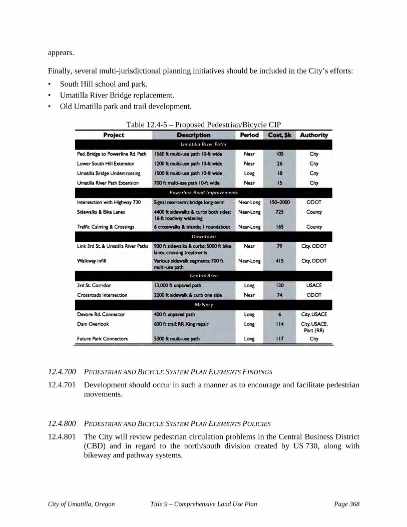
City of Umatilla, Oregon Title 9 – Comprehensive Land Use Plan Page 368
appears. Finally, several multi-jurisdictional planning initiatives should be included in the City’s efforts:
• South Hill school and park. • Umatilla River Bridge replacement. • Old Umatilla park and trail development.
Table 12.4-5 – Proposed Pedestrian/Bicycle CIP
12.4.700 PEDESTRIAN AND BICYCLE SYSTEM PLAN ELEMENTS FINDINGS 12.4.701 Development should occur in such a manner as to encourage and facilitate pedestrian
movements. 12.4.800 PEDESTRIAN AND BICYCLE SYSTEM PLAN ELEMENTS POLICIES 12.4.801 The City will review pedestrian circulation problems in the Central Business District
(CBD) and in regard to the north/south division created by US 730, along with bikeway and pathway systems.

City of Umatilla, Oregon Title 9 – Comprehensive Land Use Plan Page 369
12.4.802 The City will use that portion (at least 1%) of its State of Oregon Gas and Tax Revenue for bicycle and footpath development as required by ORS 366.514. Such monies will be placed in a fund to be used as stated, within a ten-year period.
12.4.803 It is the City’s intention to promote safe, convenient, and direct bicycle and
pedestrian circulation within the community consistent with the pedestrian and bicycle circulation plans.
12.4.804 The City will promote safe, direct and convenient pedestrian circulation by including
sidewalks on all new streets within the Urban Growth Boundary, except on limited access freeways. Retrofitting existing streets with sidewalks shall proceed on a prioritized schedule. Priority shall be given to developing sidewalks and access ways to major activity centers within the Urban Growth Boundary such as the downtown commercial center, schools, neighborhood commercial centers, and community centers.
12.4.805 Bikeways shall be included on all new arterials and collectors within the Urban
Growth Boundary, except on limited access freeways. Retrofitting of existing arterials and collectors with bike lanes shall proceed on a prioritized schedule as practical and appropriate.
12.4.806 Bicycle parking facilities shall be provided for all new multi-family developments of
four or more dwelling units, commercial, industrial, recreational, and institutional facilities.