sea-level rise implications for the coast of guyanamaria/laccei/papers/haz219_dalrymple.pdf ·...
TRANSCRIPT

Fourth LACCEI International Latin American and Caribbean Conference for Engineering and Technology (LACCEI’2006) “Breaking Frontiers and Barriers in Engineering: Education, Research and Practice”, 21-23 June 2006, Mayagüez, Puerto.
Sea-level Rise Implications for the Coast of Guyana
Omatoyo Kofi Dalrymple, MSc Graduate Assistant, Department of Civil & Environmental Engineering, University of South Florida,
Tampa, Fl 33647, USA. [email protected]
Abstract The Guyana coast has long been highly vulnerability to changes in the adjacent Atlantic Ocean on daily, seasonal, perennial, and decadal time scales. Admist these challenges, the coast, which is low-lying and supports 90% of the country’s population, also experiences high intensity seasonal rainfall often associated with extreme flooding. Particularly at risk are coastal ecosystems, coastal infrastructure, and human settlement. This current vulnerability may futher be worsen in light of the global projections on increasing sea level. The current assessment highlights the implications of sea-level changes and the exacerbation of existing coastal vulnerability based on climate change. No specific study has investigated Holocene sea-level changes along the Guyana coast, but geologic records of regional territories such as Brazil, Venezuela, and the Caribbean help to provide insight into sea-level changes in the region. Using the sea-level rise projections of the Intergovernmental Panel on Climate Change (IPCC) over the next century (2 mm/yr, 5 mm/yr and 9 mm/yr), qualitative and quantitative assessments of the impacts and changing vulnerability of the coast were made.
The assessment indicates significant increases in overtopping discharges for sea defenses; increased flood volumes and frequency; and enhanced coastal erosion. The rate of shoreline recession may increase in areas not protected by seawalls. Mangrove forests are particularly vulnerability due to coastal squeeze and human impacts. The research highlights the need for a comprehensive coastal zone management strategy; the incorporation of sea-level changes in sea defense design; strict enforcement of building codes; strengthening of disaster management institutions; and focused research on the dynamics of muddy coasts for accurate assessment of sea-level rise impacts in future studies. Keywords Climate change, coastal ecosystems, flooding, shoreline recession, vulnerability Introduction The Guyana coast is a trailing-edge coast influenced by the northwest migration of mud shoals sourced from the Amazon River (Healy et al., 2000). It is characterised by a complex system of sea defences, sections of mangrove fringes, numerous drainage canals and a low-lying coastal plain with a relatively flat foreshore. The shoreline is approximately 425 km and stretches between the borders of Venezuela and Suriname (Figure 1). The coastal area lies below the mean high tide level and floods seasonally each year, largely due to extreme intense rainfall and frequent isolated sea defense failure in many areas.
The landward limit of the coastal plain is defined by the White Sand Hills – a terrace with average elevation 60 m above mean sea level, underlain by Tertiary and Pleistocene sands 5 km to 40 km from the present shoreline (Abernathy, 1980). The coastal plain, although occupying less than 7% of Guyana’s total area, i.e., approximately 15,000 square kilometres, is of vital importance for the country because it concentrates all major administrative and economic activities. Cultivation takes place almost entirely along the narrow coastal strip that has rich alluvial soil. The main crops are sugar, rice and coconut.

Figure 1: Location map and coast of Guyana
The coast is very vulnerable to flooding in particular because of its low-lying and flat nature. For this reason, the need for an elaborate system of sea defense has been necessary to protect human settlement and economic activity. However, in recent decades, the lack of adequate maintenance of existing sea defenses, and the gradual destruction of mangrove forests have drastically reduced coastal protection. Moreover, continued groundwater extraction, soil compaction, impediments to groundwater recharge, and drainage of wetlands have resulted in coastal subsidence in some areas to the magnitude of 10 mm/yr (Khan and Sturm, 1995).
The existing vulnerability of the coast may futher be exacerbated given the projections of future sea-level rise (Warrick et al., 1996). This is attributed primarily to the anthroprogenic increase in certain greenhouse gases in the atmosphere which effect a significant increase in temeperature on the surface of the planet. This temperature increase in turn has the potential to raise sea level through thermal expansion and the melting of ice caps in polar regions (Morner, 1996; Warrick et al., 1996). The projections of the Intergovernmental Panel on Climate Change (IPCC) indicate a range of 9-88 cm increase in the mean global sea level (Church et al., 2001). However, even though there is global scientific concensus on anthroprogenic climate change, the predictions of the magnitude of future sea-level rise differ with various authors reflecting considerable uncertainty (Hendry, 1993; Church et al., 2001; Parizek and Alley, 2004; Raper and Braithwaite, 2006). Further, relative sea level varies among shorelines and is not expected to be of the same extent in all regions. This is particularly supported by analysis of detailed post-glacial and Holocene sea-level curves (Hendry, 1993; Rull et al., 1999; Martin et al., 2003), clearly showing that relative sea level varies greatly from place to place. Therefore, generalizations based on scattered data along broad regions can be misleading. This is due to the vertical displacement of continental crust by differences in the geoid, local tectonics and subsidence, and isostatic responses to melting ice caps (Rull et al., 1999).
For these reasons, site-specific investigation of coastal vulnerability is necessary and generalizations should be avoided. Kasperson et al. (2001) define coastal vulnerability as the degree to which coastal systems (both natural and man-made) are susceptible to damage from changes in the coastal regime, resulting from exposure to a perturbation or stress, and the ability or capacity of the system to cope, recover or fundamentally adapt - i.e., become a new system. This research is an assessment of the physical aspect of vulnerability of the Guyana coast to accelerated relative sea-level rise. The potential climate-induced sea-level rise scenarios of the IPCC (Church et al., 2001) were applied to assess the associated impacts. Drawing from previous studies and careful investigation of the characteristics of two study areas, the goal was to understand the construct of physical vulnerability through the assessment and identify specific areas requiring further scientific investigation for reliable future sea-level rise assessments.

Objectives The objectives of the assessment were as follows: (i) provide a conceptual model for the analysis of vulnerability of the areas (ii) define the most important physical impacts of sea-level rise (iii) recommend suitable adaptation strategies to reduce the impact of sea-level rise (iv) identify areas requiring further scientific investigation for reliable future sea-level rise assessment
Scope of Work Sea-level rise poses a series of potential impacts on the coast. These include both physical and socio-economic impacts (Douglas, 2001; Nicholls, 2002). While the impacts of sea-level rise are extensive, only first order geophysical impacts (erosion/accretion, inundation and flooding) were considered in this assessment. The assessment included the impacts on buildings, sea defenses, infrastructure, human settlement and coastal ecosystems. Two areas along the coast were selected for the study; Vreed-en-hoop, located on the western bank of the estuary of the Demerara River, and Good Hope, located on the east coast of Demerara.
Methodology A range of variables can be used to adequately describe the geophysical impacts of sea-level rise in coastal areas. These include all of the following (Sterr et al., 2003);
• increased flood frequency probabilities • erosion • inundation • rising water tables • saltwater intrusion
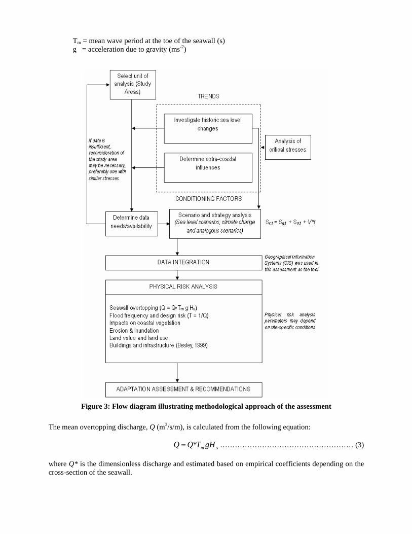
In this research, only the first three (3) variables are used. The approach taken was to combine relevant sections of various existing methodologies available for coastal vulnerability assessment and develop a site-specific procedure for the investigation. Nicholls (1998) provides a comprehensive review of vulnerability methodologies used for climate change and sea-level rise assessments. The conceptual framework (Figure 2) presented by Klein and Nicholls (1999) has been utilized to establish the basis for understanding coastal vulnerability.
A distinction can be made between natural-system vulnerability and socio-economic vulnerability to sea-level rise. However, the two concepts are clearly related and interdependent. This distinction is made explicit in the conceptual framework for coastal vulnerability illustrated in Figure 2. Klein and Nicholls (1999) showed that the natural system vulnerability is linked to the system’s susceptibility, resilience and resistance. They define susceptibility as a “measure of the natural systems sensitivity to the biogeophysical effects and it reflects its potential to be affected by sea-level rise”. Figure 2 also gives an indication of the general construct of vulnerability and shows how the physical aspect relates to the other relevant phases.
In order to estimate the physical impacts of sea level, the research deviates from previous work by establishing an appropriate approach suited for the areas of study. Further, many past studies have utilized the Bruun rule for estimation of shoreline retreat even in cases where the coast was dominated by “muddy” characteristics and processes (EPA, 2002). Based on the approach of sediment balance, the Bruun rule is deemed appropriate to sandy coastlines where the concept of sediment budget is eminently applicable (Bruun, 1962). The rule is only concerned with impacts of sea-level rise, all other factors considered stable.
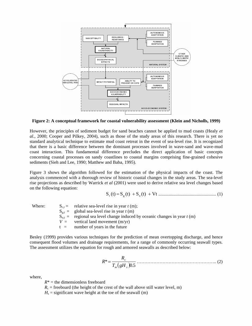
Figure 2: A conceptual framework for coastal vulnerability assessment (Klein and Nicholls, 1999)
However, the principles of sediment budget for sand beaches cannot be applied to mud coasts (Healy et al., 2000; Cooper and Pilkey, 2004), such as those of the study areas of this research. There is yet no standard analytical technique to estimate mud coast retreat in the event of sea-level rise. It is recognized that there is a basic difference between the dominant processes involved in wave-sand and wave-mud coast interaction. This fundamental difference precludes the direct application of basic concepts concerning coastal processes on sandy coastlines to coastal margins comprising fine-grained cohesive sediments (Sieh and Lee, 1990; Matthew and Baba, 1995).
Figure 3 shows the algorithm followed for the estimation of the physical impacts of the coast. The analysis commenced with a thorough review of historic coastal changes in the study areas. The sea-level rise projections as described by Warrick et al (2001) were used to derive relative sea level changes based on the following equation:
Vt (t)S (t)S (t)S ogr ++= ................................................... (1)
Where: Sr,t = relative sea-level rise in year t (m); Sg,t = global sea-level rise in year t (m) So,t = regional sea level change induced by oceanic changes in year t (m) V = vertical land movement (m/yr) t = number of years in the future
Besley (1999) provides various techniques for the prediction of mean overtopping discharge, and hence consequent flood volumes and drainage requirements, for a range of commonly occurring seawall types. The assessment utilizes the equation for rough and armored seawalls as described below:
( ) 50*
.gHTR
Rsm
c= …………………………………………….. (2)
where, R* = the dimensionless freeboard Rc = freeboard (the height of the crest of the wall above still water level, m) Hs = significant wave height at the toe of the seawall (m)
Tm = mean wave period at the toe of the seawall (s) g = acceleration due to gravity (ms-2)
Figure 3: Flow diagram illustrating methodological approach of the assessment
The mean overtopping discharge, Q (m3/s/m), is calculated from the following equation:
sm gHTQQ *= ……………………………………………… (3)
where Q* is the dimensionless discharge and estimated based on empirical coefficients depending on the cross-section of the seawall.

)/*exp(* rBRAQ −= ………………………………………….. (4)
where, r is a roughness coefficient and A & B are the empirical coefficients (Besley, 1999).
Besley (1999) provides a range of mean discharge values, which can be used to assess the impact of seawall overtopping on sea defenses and adjacent buildings. The following criteria have been used to evaluate the impact of sea-level rise on buildings and infrastructure using the calculated values for projected mean discharge.
Buildings: Q < 1x10⁻⁶ No damage
1x10⁻⁶ < Q < 3x10⁻⁵ Minor damage to fittings, etc Q > 3x10⁻⁵ Structural damage
Embankment Seawalls: Q < 0.002 No damage
0.002 < Q < 0.02 Damage if crest not protected 0.02 < Q < 0.05 Damage if back slope not protected
Q > 0.05 Damage even if fully protected
Flood frequency and probability were estimated based on annual tide records. The frequency of extreme events was determined using the method defined by (Gumbel, 1958). Return period has been defined as the reciprocal of probability of exceedance, i.e. (T = 1/P). Erosion and inundation have been assessed based on non-mathematical methods because of the lack of understanding regarding the response of muddy coast to sea-level changes. However, many previous studies have provided extensive discussion on the erosion and accretion processes of the Guyana coast (Naraine, 1968; NEDECO, 1972; Abernathy, 1980; Khan and Sturm, 1995; Prevedel, 1997; Healy et al., 2000). Qualitative description is provided for the possible impacts of increased sea level on the erosion and accretion patterns of the coast. Results and Discussion Sea-level Projections
A series of calculations were made using basic coastal engineering design data. Firstly, a design still water level (SWL) of 17.20m+GD (Georgetown datum) was established and corresponds to a 1-in-10 year return period based on previously analyzed data for the period 1970-1980. Mean sea level at the Guyana coast corresponds to approximately 15.56m+GD. A wave period of 8 seconds was used based on recommendations from NEDECO (1972). Further, a significant wave height of 0.4 times the depth of water at the coast is also established.
Historic sea-level rise at the coastline was determined as 5.1 mm/yr based on linear extrapolation of sea-level data available from 1960-1981. This value is comparable with those determined from previous studies (Daniel and Devine, 1992; Khan and Sturm, 1995; MottMacDonald, 2004) and corresponds to a regional sea-level rise of approximately 3 mm/yr (Hendry, 1993; Rull et al., 1999; Martin et al., 2003). Using 1990 as a baseline, Table 1 shows the projected increase in sea level for the three scenarios.
Table 1: Projections of sea-level rise for study areas (1990-2020)
Global Sea Level Projection (mm/yr)
Relative Sea Level Projected at Study Areas (mm)
2 213 5 303 9 423

Seawall Overtopping
The calculations for seawall overtopping are based on rock armored sea defenses that form a large section of the coastal protection regime. The increases in overtopping discharge are presented in Table 2. The values indicate that small changes in the still water level result in significant increases in mean overtopping discharges.
The projected values of Table 2 suggest that the lowest projections of sea-level rise will result in overtopping discharges that exceed the critical design criterion (0.02 m3/s/m).
Table 2: Projected mean overtopping
Relative Sea Level Scenarios Mean Overtopping by 2020 ASLR1: 213 mm 0.027 m3/s/m ASLR2: 303 mm 0.058 m3/s/m ASLR3: 423 mm 0.156 m3/s/m
Flood Frequency and Design Risk
Figure 4 presents the frequency distribution of monthly high water levels at Georgetown for the period 1963-1979. The effects of the three sea-level rise scenarios are included. It shows the flatness of the curve and subsequently the great increase in the frequency and probability of a particular water level being exceeded in any given year. The chart indicates that the probability of the current design water level (17.20m+GD) being exceeded in any year increases from approximately 6.8% to 76.7% under the first sea-level rise scenario.
Based on the analysis, the current design risk of sea defenses and other coastal structures, inclusive of power plants and buildings, which have a typical design life of 30 years, is 87.9%. This value is relatively high for sea defenses, but compensation is made by the provision of a maintenance plan, which makes allowances for the settling of the underlying soil and economy of the structure and gradually increases the crest level. It is also indicates that the frequency of maintenance will increase. The mean elevation of coastal land extending to the south of the sea defense is approximately 16.7m+GD. The study areas experience flooding from the high tides with every breach of the sea defense. However, the analysis shows that areas are likely to be experience exacerbated flooding in the event of sea defense failure over time.
Impacts on Coastal Vegetation
The existing mangrove fringes along the coast are particularly at risk from sea-level rise. In their natural state, most halophytic (salt-tolerant) coastal vegetation such as mangroves would gradually move landward following a zonation pattern based on the salinity gradient in response to a sea-level rise(Sieh and Lee, 1990). Unfortunately, the presence of coastal development, which more or less anchors the landward edge of the mangroves in the study areas, has deprived the mangroves of this latitude in migration. Moreover, the presence of human settlement within swamps serves only to exacerbate the problem as the areas are cleared for development. In the event of a rising sea level, it is highly probable that the mangrove buffer may vanish altogether; this would then expose the hitherto protected coastal development to sea attack.
Erosion and Inundation
Since coastal erosion is governed largely by episodic events, the occurrence of extreme events becomes an important parameter in the overall assessment. Increased frequency of extreme sea levels as indicated in Figure 4 may disrupt the gradual post-flooding recovery. Therefore, it follows that the 30-year natural cycle in erosion and accretion patterns postulated by NEDECO (1972) will be affected such that shoreline recession may become the dominant factor occurring at the coast. Additionally, the erosive ability of the

sea is expected to increase given the greater capacity to carry both fine materials in suspension and larger sediment fractions that lead to erosion. This will have serious consequences for coastal structures; especially seawalls that will experience increased scouring at the toe.
Figure 4: Monthly high water level readings at Port Georgetown between 1963-1979
Additionally, the increase in mean overtopping discharge will induce severe erosion of the clay embankment directly behind sea defences. The predicted values for mean overtopping discharge are sufficiently high to cause; damage if the crest is not protected (ASLR1); erosion if the back slope is not protected (ASLR2); and damage to the embankment even if it is fully protected by vegetation (ASLR3). This will in turn compromise the geotechnical and structural integrity of sea defence structures and result in breaches and consequently flooding.
Conclusion and Recommendations It has been demonstrated that climate change induced sea-level rise presents a formidable challenge for countries such as Guyana with low-lying coastal plains. Ignoring these possible changes may prove to be detrimental in the future. However, more accurate assessments of sea-level rise are required to determine site-specific impacts. There is a general need for a comprehensive coastal zone management plan that will mainstream the numerous coastal issues currently facing the country. However, more immediate measures should include the incorporation of sea-level changes in sea defense design; It is also strongly recommended that the performance of designs for sea defense be assessed at the upper rate of sea-level rise of 9 mm/year. It is clearly desirable to adopt coastal protection that can be adapted to changing sea level conditions. Also required are strict enforcement of building codes; strengthening of disaster management institutions and focused research regarding the dynamics of muddy coasts for accurate assessment of sea-level rise impacts. Lack of understanding of the dynamics of muddy coasts has prevented modeling of phenomena such as sling mud and macro-ripples, and flooding assessments have been based on a simple 1 m arithmetic rise in sea level or static qualitative risk projections. The latter ignores coastal system dynamics, human alteration of coastal processes and ecosystems, and local meteorological, ecological and geomorphological factors. We have therefore been unable to predict
accurately the time- and space-evolving characteristics of flooding, and the need for a more integrated model with dynamical inundation capabilities is advocated.
References Abernathy, C. L. (1980). "Guyana Coast: Recommendations for a Future Sea Defence Strategy."
Hydrological Research 30: 26.
Besley, P. (1999). Overtopping of seawalls - design and assessment manual. R&D Technical Report. Bristol, UK, Environment Agency.
Bruun, P. (1962). "Sea-level rise as a cause of shore erosion." Journal of the Waterways and Harbours Division, Proceedings of the American Society of Civil Engineering 7: 77-89.
Church, J. A., Gregory, J. M., Huybrechts, P., Kuhn, M., Lambeck, K., Nhuan, M. T., Qin, D. and Woodworth, P. L. (2001). Changes in sea level. Third assessment report: climate change 2001, the scientific basis. J. T. Houghton, Y. Ding, D. J. Griggset al. Cambridge University Press, UK, Intergovernmental Panel on Climate Change: 639-693.
Cooper, J. A. G. and Pilkey, O. H. (2004). "Sea-level rise and shoreline retreat: time to abandon the Bruun Rule." Global and Planetary Change 43(3-4): 157.
Daniel, R. K. and Devine, N. (1992). Quantification of risk to Guyana from an accelerated sea-level rise. International Sea-level rise Project. New Jersey.
Douglas, B. (2001). Sea-level rise: history and consequences. London, UK, Academic Press.
EPA (2002). Guyana's national vulnerability assessment to sea-level rise. Georgetown, Guyana, Guyana Environmental Protection Agency.
Gumbel, E. J. (1958). Statistics of extremes. New York, Columbia University Press.
Healy, T., Wang, Y. and Healy, J.-A. (2000). Muddy coasts of the world: processes, deposits and function. New York, Elsevier.
Hendry, M. (1993). Sea-level movements and shoreline changes. Climate Change in the Intra-Americas Sea. G. A. Maul. Arnold, London.: 115-161.
Kasperson, R., Kasperson, J. and Dow, K. (2001). Global environmental risk and society. Global Environmental Risk. R. Kasperson and J. Kasperson. Tokyo, Japan, United Nations University Press: 1-48.
Khan, M. and Sturm, M. (1995). Assessment of the vulnerability of coastal areas to sea-level rise: case study Guyana. The Hague, the Netherlands, Ministry of Transport, Public Works and Water Management.
Klein, R. J. T. and Nicholls, R. J. (1999). "Assessment of coastal vulnerability to climate change." Ambio 28(2): 182-187.
Martin, L., Dominguez, J. and Bittencourt, A. (2003). "Fluctuating Holocene sea levels in eastern and southern Brazil: evidence from multiple fossil and geometric indicators." Journal of Coastal Research 9(1): 101-124.

Matthew, J. and Baba, M. (1995). "Mudbanks of the southwest coast of India. II: Wave-mud
Interactions." Journal of Coastal Research 11(1): 179-187.
Morner, N. A. (1996). "Rapid changes in coastal sea level." Journal of Coastal Research 12(4): 797-800.
MottMacDonald (2004). Sea level rise. Guyana Drainage and Irrigation Systems Rehabilitation Project: Hydrology and Water Resources. Georgetown, Guyana, Ministry of Agriculture: 45-46.
Naraine, S. (1968). A proposed programme of sea defence works in Guyana. Georgetown, Engineering Hydraulics Division, Ministry of Works and Hydraulics.
NEDECO (1972). Report on sea defence studies. The Hague, Netherlands, Government of Guyana, Ministry of Works, Hydraulics and Supply.
Nicholls, R. (1998). Coastal vulnerability assessment for sea-level rise: evaluation and selection of methodologies for implementation. CPACC Component 6: Coastal Vulnerability and Risk Assessment., Caribbean Planning for Adaptation to Climate Change.
Nicholls, R. J. (2002). "Analysis of global impacts of sea-level rise: a case study of flooding." Physics and Chemistry of the Earth, Parts A/B/C 27(32-34): 1455-1466.
Parizek, B. R. and Alley, R. B. R. B. (2004). "Implications of increased Greenland surface melt under global-warming scenarios: ice-sheet simulations." Quaternary Science Reviews 23(9-10): 1013-1027.
Prevedel, L. M. (1997). Longshore current variations, Guyana, South America. Department of Geography. Ontario, University of Windsor. MSc: 115.
Raper, S. C. B. and Braithwaite, R. J. (2006). "Low sea level rise projections from mountain glaciers and icecaps under global warming." Nature 439(7074): 311.
Rull, V., Vegad-Vilarrubia, T. and De Pernia, N. E. (1999). "Palynological Record of an Early-Mid Holocene Mangrove in Eastern Venezuela. Implications for Sea-Level Rise and Disturbance History." Journal of Coastal Research 15(2): 496-504.
Sieh, K. C. and Lee, S. C. (1990). Implications of a global sea-level rise on coastal erosion and saltwater intrusion. Malaysia, Coastal Engineering Technical Centre.
Sterr, H., Klein, R. and Reese, S. (2003). Climate change and coastal zones: an overview of the state-of-the-art of regional and local vulnerability assessment. Climate Change in the Mediterranean: Socio-Economic Perspectives of Impacts, Vulnerability and Adaptation. C. Giupponi and M. Shechter. Cheltenham, UK, Edward Elgar Publishing: 245-278.
Warrick, R. A., Oerlemans, J., Woodworth, P. L., Meier, M. F. and le Provost, C. (1996). Changes in sea level. Climate change 1995: the science of climate change. J. T. Houghton, L. G. Meira Filho and B. A. Callander, Cambridge University Press, Cambridge: 359-405.
Authorization and Disclaimer The author authorizes LACCEI to publish the paper in the conference proceedings. Neither LACCEI nor the editors are responsible either for the content or for the implications of what is expressed in the paper.