scoutpak gps system performance at georgia … system performance at georgia whitehall forest test...
TRANSCRIPT

Product Technical Notes // december 2007
ScoutPakTM GPS SystemPerformance at Georgia Whitehall Forest Test Site
OnPO
Z Pre
cisio
n Po
sitio
ning
is a
divis
ion
of V
GI So
lutio
ns. A
rche
r Fie
ld PC
TM is
a re
cogn
ized
trade
mar
k of J
unip
er Sy
stem
s, In
c. EZ
Tag
CETM a
nd Su
bXTM ar
e rec
ogni
zed
trade
mar
ks o
f VGI
Solu
tions
. EZ
Surv
TM is
a re
gist
ered
trad
emar
k of V
GI So
lutio
ns. S
cout
Pack
TM is
a re
cogn
ized
trade
mar
k of V
GI So
lutio
ns a
nd Ju
nipe
r Sys
tem
s, In
c. Al
l oth
er tr
adem
arks
are
regi
ster
ed o
r rec
ogni
zed
by
thei
r res
pect
ive
owne
rs. W
indo
ws a
nd th
e Win
dow
s log
o ar
e tra
dem
arks
or r
egist
ered
trad
emar
ks o
f Micr
osof
t Cor
pora
tion
in th
e Un
ited
Stat
es a
nd/o
r oth
er co
untr
ies.
©
2007
VGI
Solu
tions
and
Juni
per S
yste
ms,
Inc.
All r
ight
s res
erve
d.

GPS SystemPerformance at Georgia Whitehall Forest Test Site
ScoutPakTM is powered by OnPOZ Precision Positioning and Juniper Systems //© 2007 VGI Solutions and Juniper Systems inc. All rights reserved. OnPOZ.com >> December 200702
Performance at Georgia Whitehall Forest Test Site
IntroductionJuniper Systems Inc. and OnPOZ Precision Positioning have combined efforts to offer a GPS system especially designed for foresters working in difficult environments. The ScoutPakTM GPS System uses the ultra-rugged Archer Field PCTM from Juniper Systems, Inc. and the extreme tracking capability of the SubX L1-GPS/SBAS receiver from OnPOZ to deliver unmatched performance under dense canopy.
This paper summarizes the tests performed at the Whitehall Forest test site located in Athens, Georgia. Three specific metrics are analyzed: • static accuracy using a single position and a 120-second
average point;• accuracy of dynamic positioning;• the productivity of the system; its ability to deliver
continuous positioning in dynamic mode;
The important benefit of high productivity along with reliable positioning is demonstrated.
All data collected in these tests were recorded using EZTagCETM GPS/GIS software, which is included in the ScoutPakTM GPS System. Post-processed data were generated using EZSurvTM software, which is offered as an option with the system. Both software programs are owned by ONPOZ Precision Positioning.
BackgroundSevere environments like those demonstrated under dense forest canopy degrade GPS receiver performance due to multipath effects and signal strength degradation.
The tracking capability of GPS equipment is badly affected by severe environments. GPS tracking capability is defined as the ability to maintain a GPS position while moving. Most GPS equipment currently on the market demonstrates poor tracking when used under dense canopy. This typical performance means foresters waste time in signal reacquisition while GPS mapping.
Moreover, when operating in obstructed environments, it is well known that multipath occurs more frequently when the user stops moving or slows down to receive a GPS position. To obtain good GPS positions in these severe conditions, users typically try to improve their accuracy by averaging positions. This technique might provide some good results in open sky; but, in severe environments averaging positions over short period of time does not improve accuracy significantly.
This paper focuses on the performance of the ScoutPakTM GPS System as it relates to these issues.

GPS SystemPerformance at Georgia Whitehall Forest Test Site
ScoutPakTM is powered by OnPOZ Precision Positioning and Juniper Systems //© 2007 VGI Solutions and Juniper Systems inc. All rights reserved. OnPOZ.com >> December 200703
ScoutPakTM GPS SystemThe ScoutPakTM GPS includes three components:• An Ultra-rugged Archer Field PCTM from Juniper Systems, Inc.;• The OnPOZ Precision Positioning SubXTM GPS-L1 receiver;• EZTag CETM GIS/GPS data acquisition software.
The Archer runs MS Windows Mobile Version 5.0. It is powered by the Intel XScale 520 MHz processor. The Archer meets IP67 and Mil-Std-810F standards for drop, vibration, immersion, humidity and operating temperatures. Its case is made of sturdy, lightweight magnesium and features an easy-to-grip over-molding. Its color display offers superior visibility even in bright lighting and mottled light conditions typically encountered while using it in the forest; the large, tough, backlit keys are optimized for outdoor use. The rechargeable Li-ion battery operates for more than 20 hours on one charge and recharges in 4 hours or less; intelligence within the battery provides accurate charge status to the user at all times.
The SubXTM is a multi-port (USB, RS2-232, Bluetooth) L1-GPS/SBAS GPS Receiver designed for sub-meter data acquisition (post-processed). Its extreme tracking capability for non-stop data recording in severe environments makes it the perfect choice for foresters. A 16-channel L1 SBAS receiver outputs code pseudorange, Doppler and carrier phase data. The receiver uses a rechargeable Li-ion battery that operates for
more than 17 hours on one charge. It can be used to obtain accurate real-time positions (SBAS corrected) and can enable post-processing of GPS data using the optional EZSurvTM GPS post-processing software.
attributes as you want. A rotating PlanView allows you to display vector as well as raster map data. The software also provides all functions required to monitor the incoming GPS signal.
The optional EZSurvTM GPS post-processing software is a complete solution designed to easily process raw GPS data. It provides all the flexibility you need with its fully graphical (PlanView) and Windows Explorer (ProjectManager) user interfaces. These features accommo-date different ways of working on your data. EZSurvTM is especially adapted to get the best out the ScoutPakTM GPS System. It uses a proprietary rigorous NRS (Noise Reduction System) algorithm to discriminate noise from good observations to deliver reliable positioning data in static as well as dynamic mode.
The system uses an external GPS active patch antenna. The ScoutPakTM GPS System does not need an expensive geodetic antenna while collecting data under severe conditions. The small patch antenna simply mounts on a backpack or safety helmet. All results published in this paper were collected using a simple patch antenna.
EZTag CETM GIS/GPS data acquisition software is designed to record GIS feature data along with GPS data. You can record point, line and polygon features using as many

GPS SystemPerformance at Georgia Whitehall Forest Test Site
ScoutPakTM is powered by OnPOZ Precision Positioning and Juniper Systems //© 2007 VGI Solutions and Juniper Systems inc. All rights reserved. OnPOZ.com >> December 200704
Test MethodologyThis paper focuses on three metrics: the accuracy of a static point, the dynamic accuracy (while the antenna is moving) of the system and, finally, the productivity. All these metrics were measured at the Whitehall Forest test site. On all test runs, we used a PDOP mask of 8; 15-degree mask angles. Raw GPS data were recorded at 1Hz for post-processing.
STATIc AccurAcyOur analysis shows post-processed (differentially corrected) horizontal accuracy. We used the widely known “Circular Probable Error” (CEP). The CEP represents the radius of the circle containing the best 50% of the sample (the circle being centered on the true position).
To test static accuracy, we compared recorded positions with known coordinates. During data collection, the antenna was placed (+/- 50 cm) directly over the checkpoints. We used a simple patch antenna mounted on a hat. We recorded in the field 4 test runs with static sites of 1-second (one epoch) and two runs with static sites at 120-second average.
DynAmIc AccurAcyDynamic accuracy is measured with respect to a known geometry (polygon). Dynamic accuracy is defined as the number of positions that fall within a specific region built around the polygon outline. As a measure of accuracy, we produce percentages of positions that fall within a buffer of 1.5, 3 and 5 meters.
Obviously, the operator’s ability to walk along a straight path may affect the accuracy assessment. During our test, we took as much care as possible to maintain a straight path. We used the runs at 1Hz to characterize the dynamic accuracy.
Dynamic Accuracy – Buffer Analysis
Polygon buffer
Polygon outline (trail)
Recorded GPS positions
It is important to understand that the 1-second static accuracy cannot be used to evaluate the dynamic accuracy of a GPS system since a receiver in static mode may behave differently in dynamic mode. Some receivers simply do not track while moving, so even if these receivers generate good 1-second static results, it does not tell us a lot about their dynamic capabilities. Tracking reliable satellite signals in dynamic mode is one of the most important features of a GPS receiver when used under dense canopy, so an appropriate procedure to evaluate dynamic accuracy is required.
DynAmIc PrODucTIvITyProductivity is the capability of a GPS system to track satellite signals in a steady state without frequent downtime. In this report, we measured the productivity of the dynamic mode of operation (while the antenna is moving). In static mode, productivity is usually less of an issue.
We expressed productivity as a percentage. For example, if the data files were recorded over a period of 1 hour 30 minutes at 1Hz, we would expect 5,400 positions. If at the end of the recording period we only have 3,000 positions, the productivity would be 55.5% (3000/5400).
Dynamic productivity is an important metric in forestry; low productivity introduces downtimes in field production (which is usually translated into lost benefits). Typically, in severe conditions, as most foresters have noticed, high productivity is usually associated with low accuracy. However, as the next sections will show, ScoutPakTM used along with EZSurvTM post-processing software brings new possibilities to the forest industry. Now high productivity can also guarantee reliable positioning.

GPS SystemPerformance at Georgia Whitehall Forest Test Site
ScoutPakTM is powered by OnPOZ Precision Positioning and Juniper Systems //© 2007 VGI Solutions and Juniper Systems inc. All rights reserved. OnPOZ.com >> December 200705
The GPS test site is located on the university of Georgia Whitehall Forest, approximately 4 miles from the main campus in Athens, GA. Twenty-seven points, referenced by brass survey caps mounted on rebar and surrounded by approximately 6 inches of cement, were placed in the ground. Twenty-three of these points are in a predominately hardwood forest on north and east slopes. Three other points (for a total of 30 points) are located in open fields and were the subject of four hours of data collection with survey-grade GPS receivers. These three points were used to tie the twenty-seven forested points to a control network. The final coordinates of the points have a horizontal positional precision of approximately 2 cm.
During our field test, we used eleven points (1, 4, 5, 9, 13, 15, 16, 17, 18, 19, 21) as suggested by Pete Bettinger, Associate Professor at the Warnell School of Forest Resources, University of Georgia. These eleven points have been selected as a sub-set representing the various difficulties of the test site.
TesT siTes
Post-processed Static Accuracy (m) Site CeP (50%) CeP (68%) RMS (68%)Run1/ 1-second 1,3 m 1,4 m 1,6 m
Run2/ 1-second 1,2 m 1,6 m 1,5 m
Run3/ 1-second 1,7 m 1,9 m 2,0 m
Run4/ 1-second 1,1 m 1,6 m 1,6 m
Run5/ 120-second 1,3 m 1,9 m 2,0m
Run6/ 120-second 1,7 m 2,0 m 1,9 m
Performance ResultsSTATIc AccurAcyWe used the cOrS station GAAT (located at 8km of the test site) to post-process our dataset. All processing was done using EZSurv™ Post Processor software.
ScoutPakTM standard CEP statistic at 50% as well as 68% statistic listed in the following table. We also list the well known RMS (68%) All numbers are expressed in meters as a unit of measure. Statistics are presented for each specific test run.
These results demonstrate that averaging under severe conditions does not significantly improve accuracy. This is caused by two problems: the highly correlated properties of GPS observations and multipath effects that increase in static positions under severe conditions.
In post-process mode, accuracy is usually more homogeneous than real times positions. Since the NRS algorithm used in EZSurvTM discriminates noise from good observations, we could say that averaging in post-process is useful for removing the extra multipath effects coming from the static mode. Obviously, for a longer period of static data (over 2-5 minutes), results will improve over time.
This analysis demonstrates the performance of ScoutPakTM GPS system along with EZSurvTM post-processing software under canopy. To better appreciate these results, appendix 1 describes the distribution of horizontal errors. This graphic shows the normal distribution around the truth (center of graph) that results in no systematic error in the post-processed positions.
GPS SystemPerformance at Georgia Whitehall Forest Test Site
ScoutPakTM is powered by OnPOZ Precision Positioning and Juniper Systems //© 2007 VGI Solutions and Juniper Systems inc. All rights reserved. OnPOZ.com >> December 200706
ConClusionThese test results are fully coherent with our test results on the USDA Forest Service test sites (Powell, Lubretch and Clakamas). Like our previous results, these ones from the Georgia Whitehall Forest test site establish a new standard in GPS data acquisition under canopy. For foresters, this may translate into real benefits in their field operations. Some important conclusions can be drawn regarding the ScoutPakTM GPS system.
All of our test results demonstrate that:1. High productivity can be achieved without compromising accuracy. This feature represents real dollars for field operators. 2. Dynamic GPS mapping (mapping as you walk) under dense canopy can now be used with reliable accuracy. This translates
into real dollars for field operators. 3. High accuracy is achievable under heavy canopy. These results demonstrate without a doubt that ScoutPakTM GPS system along with the EZSurvTM post-processing software can be used as a reliable and productive tool by the forest community.
Post-Process Dynamic Accuracy tRiAL +/- 1.5 M +/- 3 M +/- 5 MRun1/ 1-second 84% 100% 100%
Run2/ 1-second 79% 100% 100%
Run3/ 1-second 68% 95% 100%
Run4/ 1-second n/A n/A n/A
ScoutPakTm GPS System Post-Process ProductivitytRiAL PRoduCtivityRun1/ 1-second 100.0 %
Run2/ 1-second 100.0 %
Run3/ 1-second 100.0 %
Run4/ 1-second 100.0 %
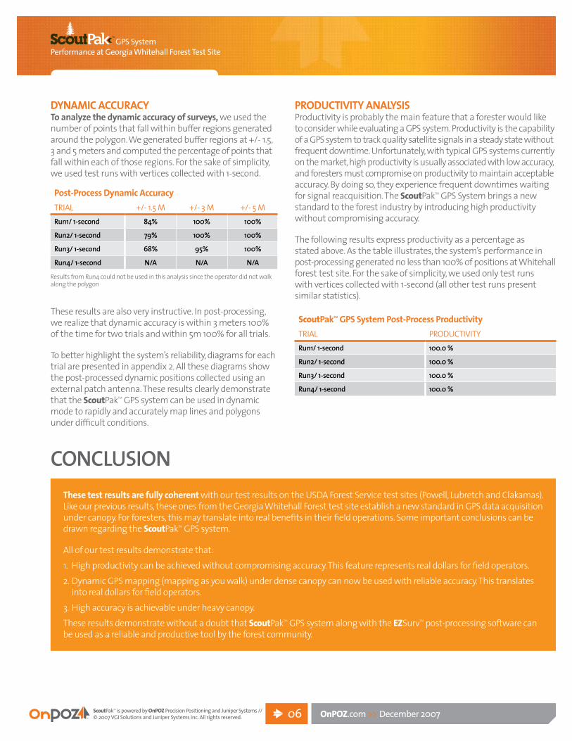
DynAmIc AccurAcyTo analyze the dynamic accuracy of surveys, we used the number of points that fall within buffer regions generated around the polygon. We generated buffer regions at +/- 1.5, 3 and 5 meters and computed the percentage of points that fall within each of those regions. For the sake of simplicity, we used test runs with vertices collected with 1-second.
Results from Run4 could not be used in this analysis since the operator did not walk along the polygon
These results are also very instructive. In post-processing, we realize that dynamic accuracy is within 3 meters 100% of the time for two trials and within 5m 100% for all trials.
To better highlight the system’s reliability, diagrams for each trial are presented in appendix 2. All these diagrams show the post-processed dynamic positions collected using an external patch antenna. These results clearly demonstrate that the ScoutPakTM GPS system can be used in dynamic mode to rapidly and accurately map lines and polygons under difficult conditions.
PrODucTIvITy AnAlySISProductivity is probably the main feature that a forester would like to consider while evaluating a GPS system. Productivity is the capability of a GPS system to track quality satellite signals in a steady state without frequent downtime. Unfortunately, with typical GPS systems currently on the market, high productivity is usually associated with low accuracy, and foresters must compromise on productivity to maintain acceptable accuracy. By doing so, they experience frequent downtimes waiting for signal reacquisition. The ScoutPakTM GPS System brings a new standard to the forest industry by introducing high productivity without compromising accuracy.
The following results express productivity as a percentage as stated above. As the table illustrates, the system’s performance in post-processing generated no less than 100% of positions at Whitehall forest test site. For the sake of simplicity, we used only test runs with vertices collected with 1-second (all other test runs present similar statistics).

GPS SystemPerformance at Georgia Whitehall Forest Test Site
ScoutPakTM is powered by OnPOZ Precision Positioning and Juniper Systems //© 2007 VGI Solutions and Juniper Systems inc. All rights reserved. OnPOZ.com >> December 200707
Appendix 1 WhITehAll FOreST TeST SITe – POST-PrOceSS hOrIZOnTAl AccurAcy
Post-processed horizontal error Distribution
Nor
th E
rror (
met
ers)
East Error (meters)
LEGEND
1 second
120 second

GPS SystemPerformance at Georgia Whitehall Forest Test Site
ScoutPakTM is powered by OnPOZ Precision Positioning and Juniper Systems //© 2007 VGI Solutions and Juniper Systems inc. All rights reserved. OnPOZ.com >> December 200708
Appendix 2run 1 / 1-second run 2 / 1-second
run 3 / 1-secondLEGEND
Data points within 1.5 m
Data points within 1.5 -3.0 m
Data points within 3.0 - 5.0 m

Prin
ted
in C
anad
a
Division of vGI Solutions1 888 495-6577OnPOZ.com
Juniper Systems435-753-1881 junipersys.com