scope of work basic contract - codot
TRANSCRIPT
i
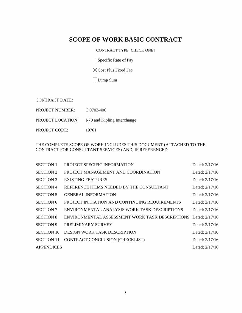
SCOPE OF WORK BASIC CONTRACT
CONTRACT TYPE [CHECK ONE]
Specific Rate of Pay
Cost Plus Fixed Fee
Lump Sum
CONTRACT DATE: PROJECT NUMBER: C 0703-406 PROJECT LOCATION: I-70 and Kipling Interchange PROJECT CODE: 19761
THE COMPLETE SCOPE OF WORK INCLUDES THIS DOCUMENT (ATTACHED TO THE CONTRACT FOR CONSULTANT SERVICES) AND, IF REFERENCED, SECTION 1 PROJECT SPECIFIC INFORMATION Dated: 2/17/16
SECTION 2 PROJECT MANAGEMENT AND COORDINATION Dated: 2/17/16
SECTION 3 EXISTING FEATURES Dated: 2/17/16
SECTION 4 REFERENCE ITEMS NEEDED BY THE CONSULTANT Dated: 2/17/16
SECTION 5 GENERAL INFORMATION Dated: 2/17/16
SECTION 6 PROJECT INITIATION AND CONTINUING REQUIREMENTS Dated: 2/17/16
SECTION 7 ENVIRONMENTAL ANALYSIS WORK TASK DESCRIPTIONS Dated: 2/17/16
SECTION 8 ENVIRONMENTAL ASSESSMENT WORK TASK DESCRIPTIONS Dated: 2/17/16
SECTION 9 PRELIMINARY SURVEY Dated: 2/17/16
SECTION 10 DESIGN WORK TASK DESCRIPTION Dated: 2/17/16
SECTION 11 CONTRACT CONCLUSION (CHECKLIST) Dated: 2/17/16
APPENDICES Dated: 2/17/16

ii
TABLE OF CONTENTS
SECTION1.................................................................................................................................................................4
1 PROJECT GOALS ............................................................................................................................... 4
2 PLANNED IMPROVEMENTS .............................................................................................................. 4
3 PROJECT COSTS ................................................................................................................................ 4
4 WORK DURATION ............................................................................................................................ 4
5 CONSULTANT RESPONSIBILITY AND DUTIES .................................................................................... 4
6 WORK PRODUCT .............................................................................................................................. 4
7 WORK PRODUCT COMPLETION ....................................................................................................... 5
8 ADDITIONAL PROJECT INFORMATION ............................................................................................. 5
9 SCOPE OF WORK ORGANIZATION .................................................................................................... 5
SECTION2.................................................................................................................................................................6
1 CDOT CONTACT ................................................................................................................................ 6
2 PROJECT COORDINATION ................................................................................................................ 6
SECTION3.................................................................................................................................................................7
1 STRUCTURES .................................................................................................................................... 7
2 UTILITIES .......................................................................................................................................... 7
3 IRRIGATION DITCHES ....................................................................................................................... 7
4 RAILROADS ....................................................................................................................................... 7
SECTION4.................................................................................................................................................................8
1 CURRENT CDOT MANUALS, SPECIFICATIONS, STANDARDS, ETC..................................................... 8
SECTION5.................................................................................................................................................................9
1 NOTICE TO PROCEED ....................................................................................................................... 9
2 PROJECT COORDINATION ................................................................................................................ 9
iii
3 ROUTINE REPORTING AND BILLING ................................................................................................. 9
4 PERSONNEL QUALIFICATIONS ........................................................................................................ 10
5 CDOT COMPUTER/SOFTWARE INFORMATION .............................................................................. 10
6 COMPUTER DATA COMPATIBILITY................................................................................................. 10
7 PROJECT DESIGN DATA AND STANDARDS ..................................................................................... 10
SECTION6...............................................................................................................................................................11
1 PROJECT INITIATION AND CONTINUING REQUIREMENTS ............................................................. 11
SECTION7...............................................................................................................................................................20
1 ENVIRONMENTAL ANALYSIS .......................................................................................................... 21
SECTION8...............................................................................................................................................................35
1 ENVIRONMENTAL DOCUMENTATION ........................................................................................... 35
SECTION9...............................................................................................................................................................39
1 PRELIMINARY SURVEY .................................................................................................................... 39
SECTION10............................................................................................................................................................42
1 PRELIMINARY ENGINEERING ......................................................................................................... 42
SECTION11............................................................................................................................................................52
1 SUPPLEMENTAL WORK .................................................................................................................. 52
2 CONTRACT COMPLETION ............................................................................................................... 52
APPENDICES..........................................................................................................................................................55
APPENDIXAREFERENCES.............................................................................................................................56
APPENDIXBSPECIFIC DESIGN CRITERIA.............................................................................................58
APPENDIXCDEFINITIONS..............................................................................................................................61
4
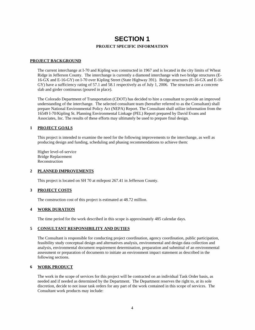
SECTION 1 PROJECT SPECIFIC INFORMATION
PROJECT BACKGROUND
The current interchange at I-70 and Kipling was constructed in 1967 and is located in the city limits of Wheat Ridge in Jefferson County. The interchange is currently a diamond interchange with two bridge structures (E-16-GX and E-16-GY) on I-70 over Kipling Street (State Highway 391). Bridge structures (E-16-GX and E-16-GY) have a sufficiency rating of 57.1 and 58.1 respectively as of July 1, 2006. The structures are a concrete slab and girder continuous (poured in place). The Colorado Department of Transportation (CDOT) has decided to hire a consultant to provide an improved understanding of the interchange. The selected consultant team (hereafter referred to as the Consultant) shall prepare National Environmental Policy Act (NEPA) Report. The Consultant shall utilize information from the 16549 I-70/Kipling St. Planning Environmental Linkage (PEL) Report prepared by David Evans and Associates, Inc. The results of these efforts may ultimately be used to prepare final design.
1 PROJECT GOALS
This project is intended to examine the need for the following improvements to the interchange, as well as producing design and funding, scheduling and phasing recommendations to achieve them: Higher level-of-service Bridge Replacement Reconstruction
2 PLANNED IMPROVEMENTS
This project is located on SH 70 at milepost 267.41 in Jefferson County.
3 PROJECT COSTS
The construction cost of this project is estimated at 48.72 million.
4 WORK DURATION
The time period for the work described in this scope is approximately 485 calendar days.
5 CONSULTANT RESPONSIBILITY AND DUTIES
The Consultant is responsible for conducting project coordination, agency coordination, public participation, feasibility study conceptual design and alternatives analysis, environmental and design data collection and analysis, environmental document requirement determination, preparation and submittal of an environmental assessment or preparation of documents to initiate an environment impact statement as described in the following sections.
6 WORK PRODUCT
The work in the scope of services for this project will be contracted on an individual Task Order basis, as needed and if needed as determined by the Department. The Department reserves the right to, at its sole discretion, decide to not issue task orders for any part of the work contained in this scope of services. The Consultant work products may include:

5
A. National Environmental Policy Act (NEPA) Report(s) - Technical summary(ies) of the engineering and
environmental considerations, assumptions, analysis methodologies, and graphic displays of the
recommended alternative(s).
B. Project Coordination
C. Schedules
D. Meeting Minutes
Detailed work product requirements are described in the following sections. All work required to complete this Scope of Work requires the use of English Units.
7 WORK PRODUCT COMPLETION All submittals must be accepted by the CDOT Contract Administrator or designee.
8 ADDITIONAL PROJECT INFORMATION
Additional information regarding this project is included in the following documents: [List available pertinent documents]
A. CDOT accident history data
B. Traffic Data
C. Geotechnical Drilling Information
D. As-constructed roadway, structure, and existing ROW plans of
E. Pavement Design Records
F. Structural Inspection Records
Copies of these documents may be obtained from CDOT Printing and Visual communications Center, Phone no. 303-757-9214, Room 117, 4201 East Arkansas Avenue, Denver, Colorado 80222. A moderate fee, determined by document size, will be charged. An additional charge will be added for requests by mail or for billing. Please provide a notice of two working days prior to obtaining the document(s) in person.
9 SCOPE OF WORK ORGANIZATION This draft scope of work has been reviewed by the Department and reflects a plan of approach based on the known goals. One factor determining the selection of a consultant is the ability of that consultant to analyze the project goals, evaluate the work elements, and formulate a work plan. This process may produce new approaches or modification to the project work elements. Because of that, all consultants should be aware that the Final Scope of Work for a project will be produced with input from the selected Consultant.
6
SECTION 2 PROJECT MANAGEMENT AND COORDINATION
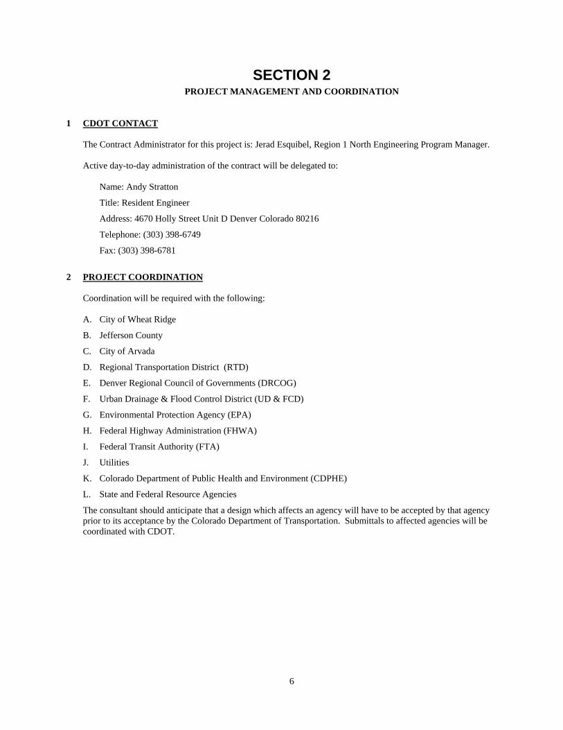
1 CDOT CONTACT The Contract Administrator for this project is: Jerad Esquibel, Region 1 North Engineering Program Manager. Active day-to-day administration of the contract will be delegated to:
Name: Andy Stratton
Title: Resident Engineer
Address: 4670 Holly Street Unit D Denver Colorado 80216
Telephone: (303) 398-6749
Fax: (303) 398-6781
2 PROJECT COORDINATION
Coordination will be required with the following: A. City of Wheat Ridge
B. Jefferson County
C. City of Arvada
D. Regional Transportation District (RTD)
E. Denver Regional Council of Governments (DRCOG)
F. Urban Drainage & Flood Control District (UD & FCD)
G. Environmental Protection Agency (EPA)
H. Federal Highway Administration (FHWA)
I. Federal Transit Authority (FTA)
J. Utilities
K. Colorado Department of Public Health and Environment (CDPHE)
L. State and Federal Resource Agencies
The consultant should anticipate that a design which affects an agency will have to be accepted by that agency prior to its acceptance by the Colorado Department of Transportation. Submittals to affected agencies will be coordinated with CDOT.
7
SECTION 3 EXISTING FEATURES
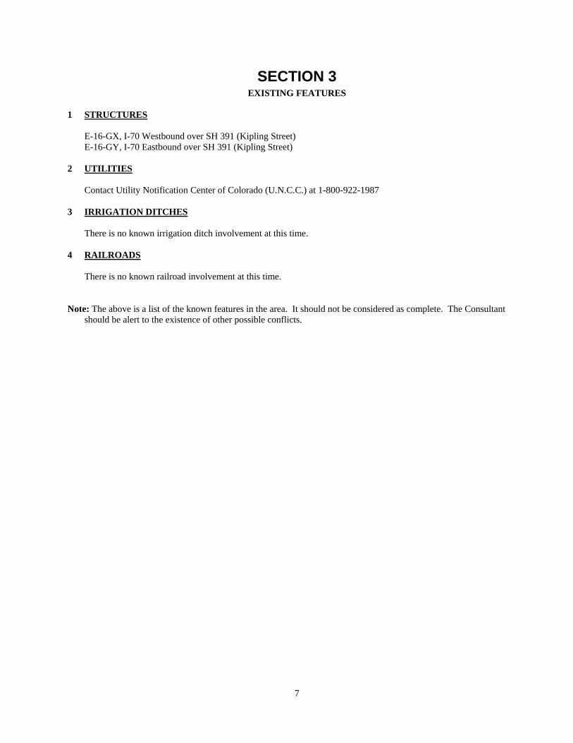
1 STRUCTURES
E-16-GX, I-70 Westbound over SH 391 (Kipling Street) E-16-GY, I-70 Eastbound over SH 391 (Kipling Street)
2 UTILITIES
Contact Utility Notification Center of Colorado (U.N.C.C.) at 1-800-922-1987
3 IRRIGATION DITCHES
There is no known irrigation ditch involvement at this time.
4 RAILROADS
There is no known railroad involvement at this time.
Note: The above is a list of the known features in the area. It should not be considered as complete. The Consultant should be alert to the existence of other possible conflicts.
8
SECTION 4 REFERENCE ITEMS NEEDED BY THE CONSULTANT
1 CURRENT CDOT MANUALS, SPECIFICATIONS, STANDARDS, ETC.
The consultant shall obtain and utilize the most recent CDOT adopted references including standards and specifications, manuals and software, electronic files of applicable standards, and all CDOT forms specified in this document or as directed by the CDOT/PM. A list of general reference material is provided in Appendix A.

9
SECTION 5 GENERAL INFORMATION
1 NOTICE TO PROCEED Work will not commence until the written Notice-to-Proceed is issued by the State with certification from the Consultant that the work will be completed within the allotted time. Work may be required, night or day, on weekends, on holidays, or on split shifts. CDOT must concur in time lost reports prior to the time lost delays being subtracted from time charges. Subject to CDOT prior approval the time charged may exclude the time lost for: A. Reviews and Approvals.
B. Response and Direction
2 PROJECT COORDINATION
A. Routine Working Contact The routine working contact will be between the CDOT Project Manager (CDOT/PM) and the Consultant Project Manager (C/PM) as defined in Appendix C. B. Project Manager Requirements Each Project Manager will provide the others with the following:
a. A written synopsis or copy of their respective contacts (both by telephone and in person) with others. b. Copies of pertinent written communications.
3 ROUTINE REPORTING AND BILLING
The Consultant will provide the following on a routine basis: A. Coordination
Coordination of all contract activities by the C/PM
B. Periodic Reports and Billings The periodic reports and billings required by CDOT Procedural Directive 400.2 (Monitoring Consultant Contracts).
C. Minutes of all Meetings: The minutes will be completed and provided to the CDOT/PM within five (5) working days after the meeting. When a definable task is discussed during a meeting, the minutes will identify the “Action Item”, the party responsible for accomplishing it, and the proposed completion date.
D. General Reports and Submittals In general, all reports and submittals must be approved by CDOT prior to their content being utilized in follow-up work effort.

10
4 PERSONNEL QUALIFICATIONS The Consultant Project Manager (C/PM) must be approved by the CDOT Contract Administrator. Certain tasks are required to be done by a Licensed Professional Engineer (PE) or a Professional Land Surveyor (PLS) who is registered with the Colorado State Board of Registration for Professional Engineers and Land Surveyors, National Institute for Certification in Engineering Technology (NICET). Other certifications may be required for project inspectors and testers.
5 CDOT COMPUTER/SOFTWARE INFORMATION The consultant shall utilize the most recent CDOT adopted software. The primary software used by CDOT is as follows: A. Earthwork InRoads
B. Drafting/CADD InRoads and Microstation with CDOT’s formatting configurations and standards
C. Survey CDOT Inroads TMOSS
D. Geometry CDOT COGO (Coordinate Geometry)
E. Bridge CDOT Staff Bridge software shall be used in either design or design check
F. Estimating Transport (an AASHTO sponsored software)
G. Specifications Microsoft Word
H. Traffic Highway Capacity Software (HCS)
I. Traffic Operations VISSIM and DYNASMART
J. Travel Demand Model TransCAD
K. Traffic Signals Synchro/Sim Traffic
L. Hydraulics Hydrologic Engineering Center's River Analysis System (HEC-RAS)
M. Pavement Design DARWin (AASHTO)
N. Scheduling Microsoft Project
O. GIS ESRI, ArcMap geodatabases (Projection: UTM NAD 83, Zone 13)
P. Noise Modeling TNM v2.5
Q. Misc Microsoft Word, Excel, Power Point
R. Reports Adobe Acrobat 7.0 Professional, Microsoft Word
S. Air Quality CAL3QHCR Hot Spot Model
6 COMPUTER DATA COMPATIBILITY
The data format CDOT presently utilizes which Consultants shall be required to use for submitting roadway design data is: Inroads. The data format used by the Consultant to submit surveying and photogrammetric data shall be as determined by the CDOT/PM in coordination with the respective Region PLS. The data format for submitting design computer files shall be compatible with the latest version of the adopted CDOT program. The Consultant shall immediately notify the CDOT/PM if the firm is unable to produce the desired format for any reason and cease work until the problem is resolved. Refer to Table 1, Submittals, for additional information regarding the InRoads and TMOSS formats and the acceptable transmittal media.
7 PROJECT DESIGN DATA AND STANDARDS A. General:
Appendix A is a list of technical references applicable to CDOT work. The consultant is responsible for ensuring compliance with the latest CDOT adopted version of the listed references. Conflicts in criteria shall be resolved by the CDOT/PM.

11
SECTION 6 PROJECT INITIATION AND CONTINUING REQUIREMENTS
This list establishes the consultant’s individual task responsibility. The consultant shall maintain the ability to perform all work tasks which are indicated below by an ‘X’ in the consultant column, in accordance with the forms and conditions contained herein, and the applicable CDOT standards. Selected work tasks shall be assigned only after coordination and consultation with CDOT. The Consultant is also responsible for coordinating the required work schedule for those tasks accomplished by CDOT and other agencies. The Consultant should review this entire section to identify applicable material. Contact the Colorado Department of Transportation/Project Manager (CDOT/PM) if clarification is required (see Section 2.1, CDOT Contact). The following activities of communication, consensus building, project team reviews, conceptual design, data gathering, documentation, and formal public notice should be planned by the Consultant and coordinated with the CDOT/PM. The time of their accomplishment will overlap and parallel paths of activity should be planned to finish the development phase in accordance with the shortest possible schedule. The type and number of meetings, documents, etc., will depend on the category and characteristics of the project work. A project plan shall be developed by the Consultant which satisfies the requirements of the project development. This plan must be approved by the Contract Administrator (see Section 2.1, CDOT Contact) before starting the work.
CD
OT
(C
)/
Oth
er*
Con
sult
ant
Not
A
pp
lica
ble
1 PROJECT INITIATION AND CONTINUING REQUIREMENTS
A. Initial Project Meeting An initial project kick-off meeting will be held, coordinated by the Consultant, and conducted by CDOT. The meeting will review the Project Management Plan, project scope, schedule, key milestones, and project study area boundary. The meeting may include an on-site inspection to familiarize the entire project team with the character and conditions of the area. The Consultant shall develop an invitation list in coordination with CDOT, send notices with a draft agenda, and provide meeting minutes to all those invited. The Consultant will facilitate a chartering session among CDOT, City of Wheat Ridge, and Consultant team members to establish the project charter, including defining the team's purpose and establish critical success factors, goals, roles and responsibilities, operating guidelines, interpersonal behaviors, and other elements. The charter will be a written document that is signed by all participants.
X X
B. Project Management Plan The Consultant shall submit a plan for managing the project, including work assignments, project schedule, document quality assurance program, administrative record, document and agency reviews, and other project needs.
X X
C. Resource Review Consultant shall review relevant standards and specifications and document environmental requirements applicable to the project. This task shall include two meetings, one with CDOT and one with City of Wheat Ridge representatives to discuss the initial work efforts of the project.
X X

12
CD
OT
(C
)/
Oth
er*
Con
sult
ant
Not
A
pp
lica
ble
D. Project Schedule The initial project schedule, to be prepared by the Consultant, will be reviewed with the CDOT Project Manager and project team, and refined to provide detail as requested. Modifications shall be made for acceptance by CDOT. The schedule will be reviewed and discussed at regular intervals and updated as necessary. The work in this scope is expected to take approximately 18 to 24 months to complete.
X
E. Obtain Necessary Trespass Rights and Permits Some activities may require work on land not controlled by CDOT. In such cases CDOT shall obtain the necessary written permission to enter the premises. CDOT Form 730 may be used for this purpose. The Consultant will assist CDOT with work efforts consisting of the following activities:
X X
a Consultant shall develop ownership lists with names and telephone numbers of persons to contact for Right-of-Entry (ROE). Prepare initial mailing list from this effort.
b CDOT shall prepare ROEs for 1st tier properties for field work and other activities as they arise.
c CDOT shall track status of ROEs, when sent, when returned, approved or rejected, conditions, other interested parties and tenants, etc. The ROEs shall apply to CDOT and Consultant personnel.
d Consultant shall obtain permits, as required, for fieldwork activities.
F. Plan and arrange Required Traffic Control Consultant field activities that interfere with traffic operations within existing roadways will require control of traffic. The Consultant will plan and provide any required traffic control for the survey, testing, or the design process. Traffic control operations will be in accordance with the MUTCD. The proposed Method for Handling Traffic (MHT) must be submitted to the CDOT/PM. Also, certification of the Traffic Control Supervisor as a Worksite Traffic Supervisor by the American Traffic Safety Services Association (ATSSA) or as a TCS (Traffic Control Supervisor) by the Colorado Contractors Association (CCA) shall be required. The Consultant will work directly with CDOT personnel to prepare and submit appropriate basic traffic control plans for work tasks which may be required and are within traveled roadway to CDOT for approval. Any work within the City of Wheat Ridge's right of way will require a permit and traffic control plan approved in advance by the City of Wheat Ridge
X
G. Progress Meetings CDOT and the Consultant will meet at regular intervals, to coordinate and track work efforts, progress and issues, and to work towards resolution of potential problems. The Consultant Project Manager shall provide a status report of the project schedule and budget at regular intervals. The Consultant Project Manager shall conduct the meetings, send meeting notices, agendas and handout materials, and prepare and distribute meeting minutes. The minutes of each meeting shall track and report progress on action items identified during previous meetings. Team meetings will be organized as follows:
X X

13
CD
OT
(C
)/
Oth
er*
Con
sult
ant
Not
A
pp
lica
ble
a Project Team Meetings: Project Team consists of CDOT and Consultant Project Managers. Team will meet on a bi-weekly basis to review status of and manage the overall project progress, schedule, and work plan. Team meetings will be used to conduct primary evaluations and decisions required during the EA process.
b Technical Team Meetings: Technical Team consists of CDOT, City of Wheat Ridge, and Consultant technical task leaders responsible for coordination of technical information as needed Team will meet on a 6-week basis to review status and progress of project technical materials and conceptual designs.
H. Scoping, Public Meetings, Agency and Public Involvement This section identifies Agency and Public Involvement tasks anticipated for this project. The tasks support the Agency and Public Involvement strategies put forth in the Public Involvement Plan (PIP).
a Public Involvement Plan (PIP): The Consultant shall prepare a Public Involvement Plan setting out goals and methods for contacting and engaging members of the public and other interested parties during the NEPA process. The plan will include strategies to integrate Environmental Justice principles into the project. This plan shall include development of materials for distribution, schedules that will guide the project team through the Environmental Assessment process, including scoping meetings, public meetings, community outreach, website development and small group meetings. The PIP will include a chapter on agency coordination to establish clear expectations for the role of local governments and agency in the decision making process. This chapter will identify the responsibilities of the cooperating and participating agencies, as well as define procedures and schedule for coordination. The procedures will support timely input at decision milestones and collaborative problem solving, where appropriate. The PIP shall be submitted to the CDOT project manager for review and approval prior to agency public scoping meetings.
X X
b Stakeholder Contact Database and Postage: The Consultant shall develop and maintain a computerized listing of all project contacts, including committee members, technical staff, interested officials, and all citizens who come to meetings, provide written comments concerning the project, or express interest in being added to the list. The computerized listing will be used to send notice of meetings, mail newsletters, and other necessary communications. The first newsletter will be used to update the stakeholder database. Postage for newsletters is assumed to be first class for the first newsletter, and bulk mail for subsequent mailings. First class postage will provide returned newsletters for invalid addresses. With this information, the stakeholder database will be updated.
X
14
CD
OT
(C
)/
Oth
er*
Con
sult
ant
Not
A
pp
lica
ble
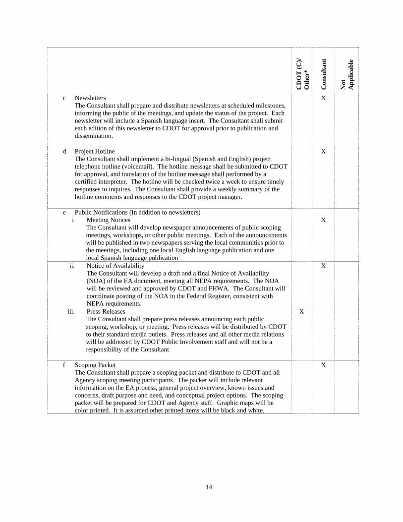
c Newsletters The Consultant shall prepare and distribute newsletters at scheduled milestones, informing the public of the meetings, and update the status of the project. Each newsletter will include a Spanish language insert. The Consultant shall submit each edition of this newsletter to CDOT for approval prior to publication and dissemination.
X
d Project Hotline The Consultant shall implement a bi-lingual (Spanish and English) project telephone hotline (voicemail). The hotline message shall be submitted to CDOT for approval, and translation of the hotline message shall performed by a certified interpreter. The hotline will be checked twice a week to ensure timely responses to inquires. The Consultant shall provide a weekly summary of the hotline comments and responses to the CDOT project manager.
X
e Public Notifications (In addition to newsletters) i. Meeting Notices
The Consultant will develop newspaper announcements of public scoping meetings, workshops, or other public meetings. Each of the announcements will be published in two newspapers serving the local communities prior to the meetings, including one local English language publication and one local Spanish language publication
X
ii. Notice of Availability The Consultant will develop a draft and a final Notice of Availability (NOA) of the EA document, meeting all NEPA requirements. The NOA will be reviewed and approved by CDOT and FHWA. The Consultant will coordinate posting of the NOA in the Federal Register, consistent with NEPA requirements.
X
iii. Press Releases The Consultant shall prepare press releases announcing each public scoping, workshop, or meeting. Press releases will be distributed by CDOT to their standard media outlets. Press releases and all other media relations will be addressed by CDOT Public Involvement staff and will not be a responsibility of the Consultant
X
f Scoping Packet The Consultant shall prepare a scoping packet and distribute to CDOT and all Agency scoping meeting participants. The packet will include relevant information on the EA process, general project overview, known issues and concerns, draft purpose and need, and conceptual project options. The scoping packet will be prepared for CDOT and Agency staff. Graphic maps will be color printed. It is assumed other printed items will be black and white.
X
15
CD
OT
(C
)/
Oth
er*
Con
sult
ant
Not
A
pp
lica
ble
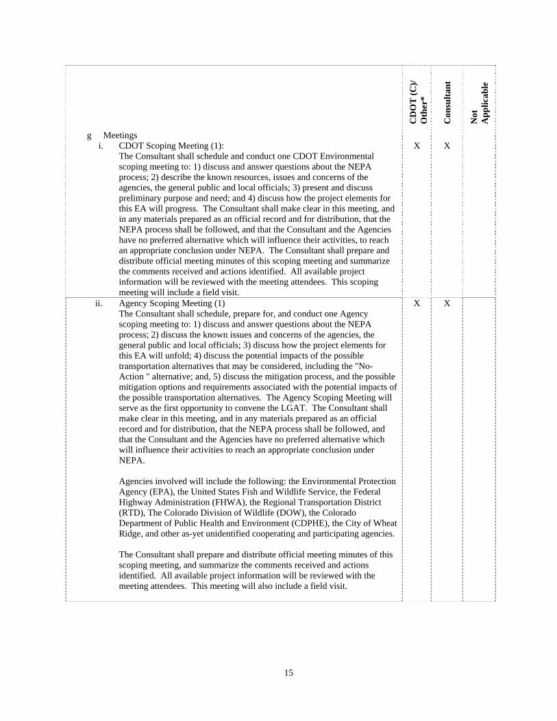
g Meetings i. CDOT Scoping Meeting (1):
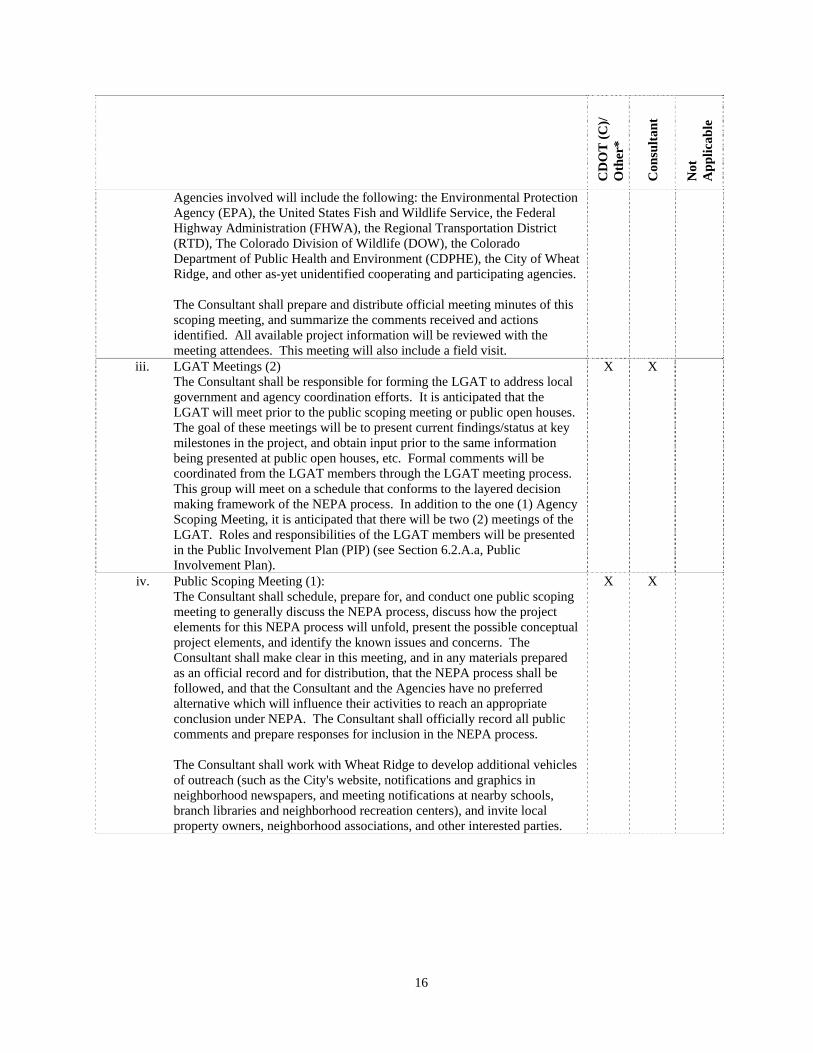
The Consultant shall schedule and conduct one CDOT Environmental scoping meeting to: 1) discuss and answer questions about the NEPA process; 2) describe the known resources, issues and concerns of the agencies, the general public and local officials; 3) present and discuss preliminary purpose and need; and 4) discuss how the project elements for this EA will progress. The Consultant shall make clear in this meeting, and in any materials prepared as an official record and for distribution, that the NEPA process shall be followed, and that the Consultant and the Agencies have no preferred alternative which will influence their activities, to reach an appropriate conclusion under NEPA. The Consultant shall prepare and distribute official meeting minutes of this scoping meeting and summarize the comments received and actions identified. All available project information will be reviewed with the meeting attendees. This scoping meeting will include a field visit.
X
X
ii. Agency Scoping Meeting (1) The Consultant shall schedule, prepare for, and conduct one Agency scoping meeting to: 1) discuss and answer questions about the NEPA process; 2) discuss the known issues and concerns of the agencies, the general public and local officials; 3) discuss how the project elements for this EA will unfold; 4) discuss the potential impacts of the possible transportation alternatives that may be considered, including the "No-Action " alternative; and, 5) discuss the mitigation process, and the possible mitigation options and requirements associated with the potential impacts of the possible transportation alternatives. The Agency Scoping Meeting will serve as the first opportunity to convene the LGAT. The Consultant shall make clear in this meeting, and in any materials prepared as an official record and for distribution, that the NEPA process shall be followed, and that the Consultant and the Agencies have no preferred alternative which will influence their activities to reach an appropriate conclusion under NEPA.
Agencies involved will include the following: the Environmental Protection Agency (EPA), the United States Fish and Wildlife Service, the Federal Highway Administration (FHWA), the Regional Transportation District (RTD), The Colorado Division of Wildlife (DOW), the Colorado Department of Public Health and Environment (CDPHE), the City of Wheat Ridge, and other as-yet unidentified cooperating and participating agencies. The Consultant shall prepare and distribute official meeting minutes of this scoping meeting, and summarize the comments received and actions identified. All available project information will be reviewed with the meeting attendees. This meeting will also include a field visit.
X X
16
CD
OT
(C
)/
Oth
er*
Con
sult
ant
Not
A
pp
lica
ble
Agencies involved will include the following: the Environmental Protection Agency (EPA), the United States Fish and Wildlife Service, the Federal Highway Administration (FHWA), the Regional Transportation District (RTD), The Colorado Division of Wildlife (DOW), the Colorado Department of Public Health and Environment (CDPHE), the City of Wheat Ridge, and other as-yet unidentified cooperating and participating agencies.
The Consultant shall prepare and distribute official meeting minutes of this scoping meeting, and summarize the comments received and actions identified. All available project information will be reviewed with the meeting attendees. This meeting will also include a field visit.
iii. LGAT Meetings (2) The Consultant shall be responsible for forming the LGAT to address local government and agency coordination efforts. It is anticipated that the LGAT will meet prior to the public scoping meeting or public open houses. The goal of these meetings will be to present current findings/status at key milestones in the project, and obtain input prior to the same information being presented at public open houses, etc. Formal comments will be coordinated from the LGAT members through the LGAT meeting process. This group will meet on a schedule that conforms to the layered decision making framework of the NEPA process. In addition to the one (1) Agency Scoping Meeting, it is anticipated that there will be two (2) meetings of the LGAT. Roles and responsibilities of the LGAT members will be presented in the Public Involvement Plan (PIP) (see Section 6.2.A.a, Public Involvement Plan).
X X
iv. Public Scoping Meeting (1): The Consultant shall schedule, prepare for, and conduct one public scoping meeting to generally discuss the NEPA process, discuss how the project elements for this NEPA process will unfold, present the possible conceptual project elements, and identify the known issues and concerns. The Consultant shall make clear in this meeting, and in any materials prepared as an official record and for distribution, that the NEPA process shall be followed, and that the Consultant and the Agencies have no preferred alternative which will influence their activities to reach an appropriate conclusion under NEPA. The Consultant shall officially record all public comments and prepare responses for inclusion in the NEPA process.
The Consultant shall work with Wheat Ridge to develop additional vehicles of outreach (such as the City's website, notifications and graphics in neighborhood newspapers, and meeting notifications at nearby schools, branch libraries and neighborhood recreation centers), and invite local property owners, neighborhood associations, and other interested parties.
X X
17
CD
OT
(C
)/
Oth
er*
Con
sult
ant
Not
A
pp
lica
ble
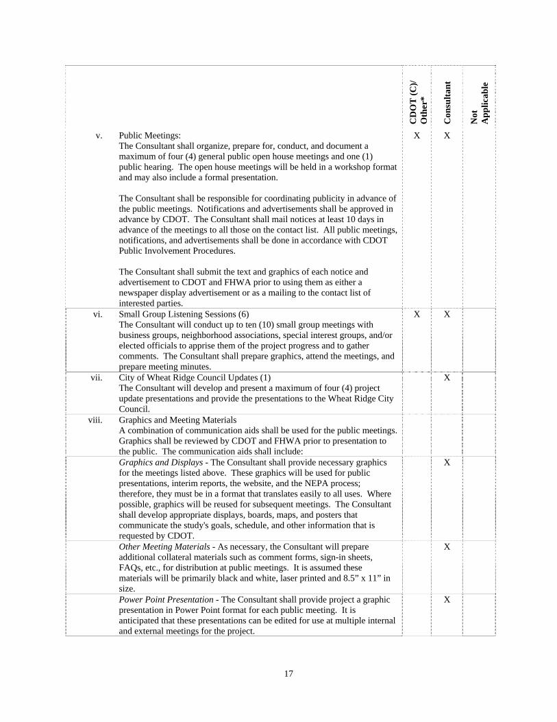
v. Public Meetings: The Consultant shall organize, prepare for, conduct, and document a maximum of four (4) general public open house meetings and one (1) public hearing. The open house meetings will be held in a workshop format and may also include a formal presentation.
The Consultant shall be responsible for coordinating publicity in advance of the public meetings. Notifications and advertisements shall be approved in advance by CDOT. The Consultant shall mail notices at least 10 days in advance of the meetings to all those on the contact list. All public meetings, notifications, and advertisements shall be done in accordance with CDOT Public Involvement Procedures.
The Consultant shall submit the text and graphics of each notice and advertisement to CDOT and FHWA prior to using them as either a newspaper display advertisement or as a mailing to the contact list of interested parties.
X X
vi. Small Group Listening Sessions (6) The Consultant will conduct up to ten (10) small group meetings with business groups, neighborhood associations, special interest groups, and/or elected officials to apprise them of the project progress and to gather comments. The Consultant shall prepare graphics, attend the meetings, and prepare meeting minutes.
X X
vii. City of Wheat Ridge Council Updates (1) The Consultant will develop and present a maximum of four (4) project update presentations and provide the presentations to the Wheat Ridge City Council.
X
viii. Graphics and Meeting Materials A combination of communication aids shall be used for the public meetings. Graphics shall be reviewed by CDOT and FHWA prior to presentation to the public. The communication aids shall include:
Graphics and Displays - The Consultant shall provide necessary graphics for the meetings listed above. These graphics will be used for public presentations, interim reports, the website, and the NEPA process; therefore, they must be in a format that translates easily to all uses. Where possible, graphics will be reused for subsequent meetings. The Consultant shall develop appropriate displays, boards, maps, and posters that communicate the study's goals, schedule, and other information that is requested by CDOT.
X
Other Meeting Materials - As necessary, the Consultant will prepare additional collateral materials such as comment forms, sign-in sheets, FAQs, etc., for distribution at public meetings. It is assumed these materials will be primarily black and white, laser printed and 8.5” x 11” in size.
X
Power Point Presentation - The Consultant shall provide project a graphic presentation in Power Point format for each public meeting. It is anticipated that these presentations can be edited for use at multiple internal and external meetings for the project.
X
18
CD
OT
(C
)/
Oth
er*
Con
sult
ant
Not
A
pp
lica
ble
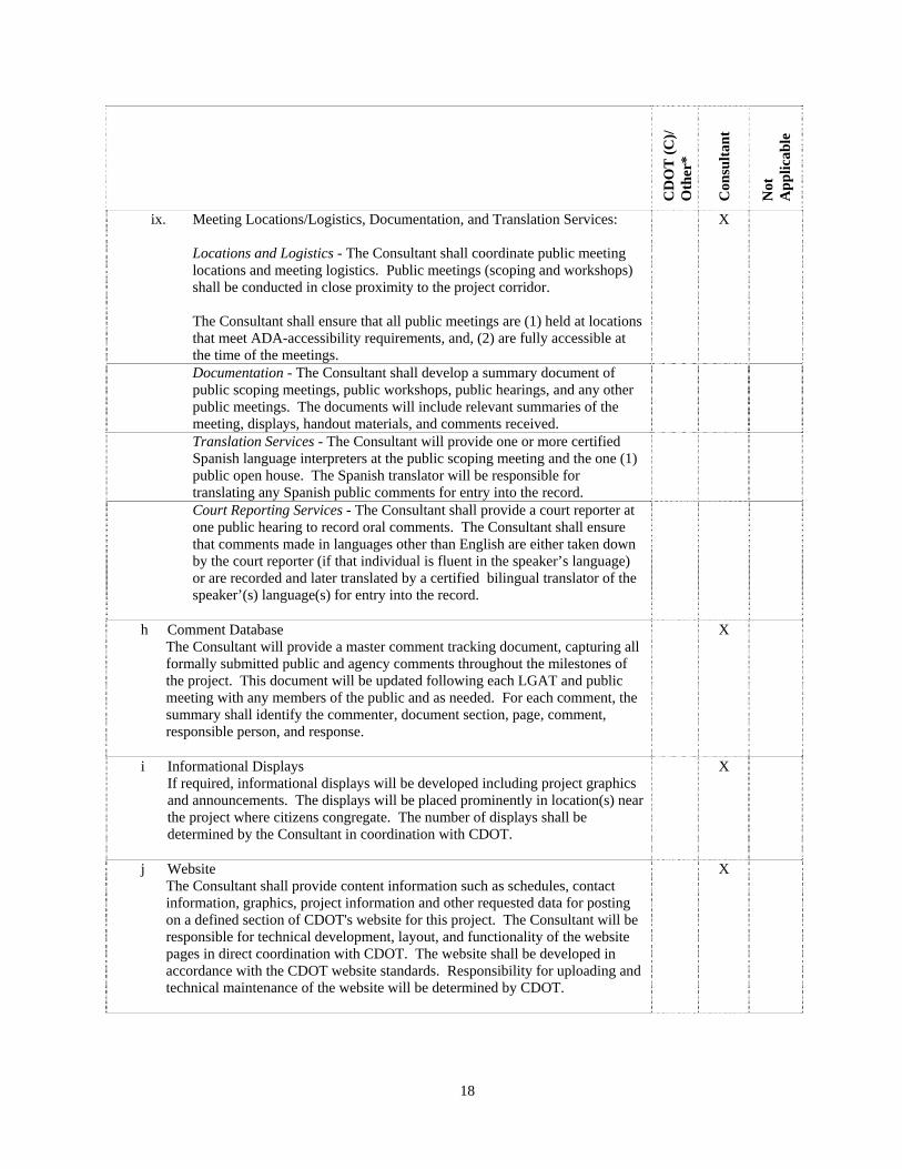
ix. Meeting Locations/Logistics, Documentation, and Translation Services: Locations and Logistics - The Consultant shall coordinate public meeting locations and meeting logistics. Public meetings (scoping and workshops) shall be conducted in close proximity to the project corridor.
The Consultant shall ensure that all public meetings are (1) held at locations that meet ADA-accessibility requirements, and, (2) are fully accessible at the time of the meetings.
X
Documentation - The Consultant shall develop a summary document of public scoping meetings, public workshops, public hearings, and any other public meetings. The documents will include relevant summaries of the meeting, displays, handout materials, and comments received.
Translation Services - The Consultant will provide one or more certified Spanish language interpreters at the public scoping meeting and the one (1) public open house. The Spanish translator will be responsible for translating any Spanish public comments for entry into the record.
Court Reporting Services - The Consultant shall provide a court reporter at one public hearing to record oral comments. The Consultant shall ensure that comments made in languages other than English are either taken down by the court reporter (if that individual is fluent in the speaker’s language) or are recorded and later translated by a certified bilingual translator of the speaker’(s) language(s) for entry into the record.
h Comment Database The Consultant will provide a master comment tracking document, capturing all formally submitted public and agency comments throughout the milestones of the project. This document will be updated following each LGAT and public meeting with any members of the public and as needed. For each comment, the summary shall identify the commenter, document section, page, comment, responsible person, and response.
X
i Informational Displays If required, informational displays will be developed including project graphics and announcements. The displays will be placed prominently in location(s) near the project where citizens congregate. The number of displays shall be determined by the Consultant in coordination with CDOT.
X
j Website The Consultant shall provide content information such as schedules, contact information, graphics, project information and other requested data for posting on a defined section of CDOT's website for this project. The Consultant will be responsible for technical development, layout, and functionality of the website pages in direct coordination with CDOT. The website shall be developed in accordance with the CDOT website standards. Responsibility for uploading and technical maintenance of the website will be determined by CDOT.
X
19
CD
OT
(C
)/
Oth
er*
Con
sult
ant
Not
A
pp
lica
ble
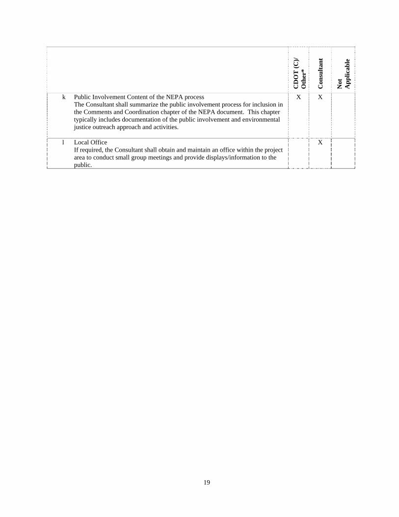
k Public Involvement Content of the NEPA process The Consultant shall summarize the public involvement process for inclusion in the Comments and Coordination chapter of the NEPA document. This chapter typically includes documentation of the public involvement and environmental justice outreach approach and activities.
X X
l Local Office If required, the Consultant shall obtain and maintain an office within the project area to conduct small group meetings and provide displays/information to the public.
X

20
SECTION 7 ENVIRONMENTAL ANALYSIS WORK TASK DESCRIPTIONS
This list establishes the consultant’s individual task responsibility. The consultant shall maintain the ability to perform all work tasks which are indicated below by an ‘X’ in the consultant column, in accordance with the forms and conditions contained herein, and the applicable CDOT standards. Selected work tasks shall be assigned only after coordination and consultation with CDOT. The Consultant is also responsible for coordinating the required work schedule for those tasks accomplished by CDOT and other agencies. The Consultant should review this entire section to identify applicable material. Contact the Colorado Department of Transportation/Project Manager (CDOT/PM) if clarification is required (see Section 2.1, CDOT Contact). The following activities of communication, consensus building, project team reviews, conceptual design, data gathering, documentation, and formal public notice should be planned by the Consultant and coordinated with the CDOT/PM. The time of their accomplishment will overlap and parallel paths of activity should be planned to finish the development phase in accordance with the shortest possible schedule. The type and number of meetings, documents, etc., will depend on the category and characteristics of the project work. A project plan shall be developed by the Consultant which satisfies the requirements of the project development. This plan must be approved by the Contract Administrator (see Section 2.1, CDOT Contact) before starting the work. The goal of the environmental analysis of this project is to definitively and comprehensively examine the transportation needs of the project area, to subject the transportation alternatives to a NEPA analysis, and to generate the appropriate NEPA documents following the requirements of CFR 23 Part 771 and the FHWA Technical Advisory T6640.8A. All environmental documentation, reports and technical memos shall be submitted to CDOT Region 1, and may be supplied to FHWA, RTD, CDOT Environmental Programs Branch (EPB) and the City of Wheat Ridge for early review as appropriate and necessary. The Consultant shall develop a range of reasonable alternatives that will satisfy the Purpose and Need requirements of the project, including, but not limited to, those identified in earlier and ongoing studies of the area. Whenever required and appropriate, CDOT will assist the Consultant in the development of conceptual layouts and preliminary design, which will satisfy the requirements for each alternative. In the process of developing alternatives, the Consultant should consider, among other factors, alternative routes, alternatives that avoid or minimize environmental impacts, accident history, congestion effects of the proposed improvements on the existing roadway system, and right-of-way impacts. The alternatives must take into account the projected opening day and design year traffic volumes as developed for this Scope, or as modified through later studies and calculations by CDOT. The Consultant shall evaluate the impacts of these alternatives according to NEPA guidelines and shall examine the degree to which these alternatives satisfy the Purpose and Need requirements of the project. The Consultant shall set out these evaluations both schematically and in narrative form for review. The process of developing alternatives could potentially be streamlined if analysis shows that an alternative from the Planning and Environmental Linkages (PEL) study that was conducted for this interchange can be carried forward into NEPA as the Preferred Alternative. In the Alternatives Chapter of the EA, the Consultant shall include a full definition of the preferred alternative for the projected opening day and 20 years into the future from the projected opening day. In addition, each of the analyzed alternatives shall be fully defined and described.
21
CD
OT
(C
)/
Oth
er*
Con
sult
ant
Not
A
pp
lica
ble
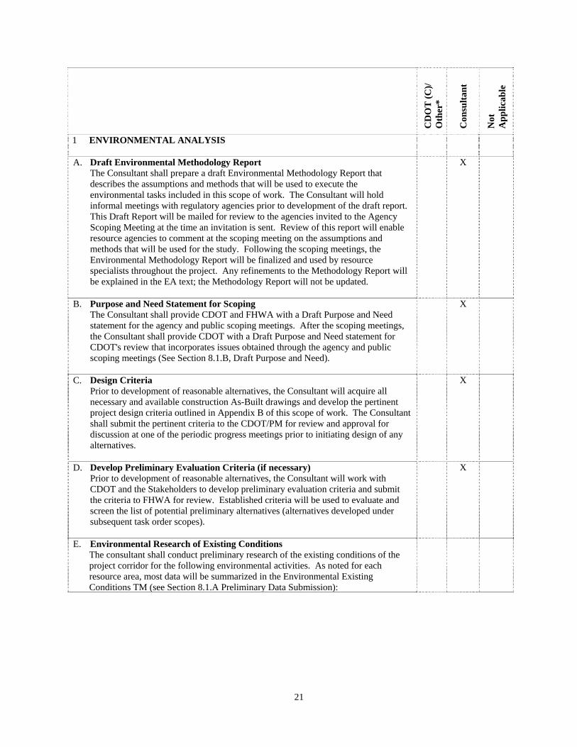
1 ENVIRONMENTAL ANALYSIS A. Draft Environmental Methodology Report
The Consultant shall prepare a draft Environmental Methodology Report that describes the assumptions and methods that will be used to execute the environmental tasks included in this scope of work. The Consultant will hold informal meetings with regulatory agencies prior to development of the draft report. This Draft Report will be mailed for review to the agencies invited to the Agency Scoping Meeting at the time an invitation is sent. Review of this report will enable resource agencies to comment at the scoping meeting on the assumptions and methods that will be used for the study. Following the scoping meetings, the Environmental Methodology Report will be finalized and used by resource specialists throughout the project. Any refinements to the Methodology Report will be explained in the EA text; the Methodology Report will not be updated.
X
B. Purpose and Need Statement for Scoping The Consultant shall provide CDOT and FHWA with a Draft Purpose and Need statement for the agency and public scoping meetings. After the scoping meetings, the Consultant shall provide CDOT with a Draft Purpose and Need statement for CDOT's review that incorporates issues obtained through the agency and public scoping meetings (See Section 8.1.B, Draft Purpose and Need).
X
C. Design Criteria Prior to development of reasonable alternatives, the Consultant will acquire all necessary and available construction As-Built drawings and develop the pertinent project design criteria outlined in Appendix B of this scope of work. The Consultant shall submit the pertinent criteria to the CDOT/PM for review and approval for discussion at one of the periodic progress meetings prior to initiating design of any alternatives.
X
D. Develop Preliminary Evaluation Criteria (if necessary) Prior to development of reasonable alternatives, the Consultant will work with CDOT and the Stakeholders to develop preliminary evaluation criteria and submit the criteria to FHWA for review. Established criteria will be used to evaluate and screen the list of potential preliminary alternatives (alternatives developed under subsequent task order scopes).
X
E. Environmental Research of Existing Conditions The consultant shall conduct preliminary research of the existing conditions of the project corridor for the following environmental activities. As noted for each resource area, most data will be summarized in the Environmental Existing Conditions TM (see Section 8.1.A Preliminary Data Submission):
22
CD
OT
(C
)/
Oth
er*
Con
sult
ant
Not
A
pp
lica
ble
a Noise Study The Consultant shall prepare a technical noise assessment analysis in accordance with CDOT Noise Analysis and Abatement Guidelines (revised 12/1/02) and submit a comprehensive noise assessment document to CDOT for review and acceptance. The analysis shall consist of the following, each of which must be covered in the noise assessment document: Definition of relevant noise abatement criteria and identification of noise
sensitive land uses. Determination of existing noise levels (by measurement and/or modeling). Prediction of future traffic noise levels for all alternatives, including the no-
action alternative, using FHWA’s Traffic Noise Model (TNM v2.5) as required by EPB.
Determination of traffic noise impacts. Identification and evaluation of feasibility and reasonableness of noise
abatement measures. Development of recommendations regarding noise abatement measures. Assessment of construction related noise issues. Prepare technical memorandum documenting all of the above.
Prior to the public scoping meeting the consultant shall prepare a preliminary noise monitoring and analysis to determine the extent of the existing 66 dBA noise level contour. The consultant shall document these preliminary findings in a TM.
b Air Quality (Project Specific) The Consultant shall perform the necessary carbon monoxide, PM-10, ozone and mobile source air toxics analysis, and provide the results for integration into the NEPA document. Site-specific air quality monitoring is not required.
The Consultant shall coordinate with the Region 1 specialist and CDOT EPB specialist and attend coordination meetings with the Colorado Air Pollution Control Division and the Environmental Protection Agency.
The Consultant shall submit to the Region 1 specialist and EPB for approval a technical memorandum that includes methodology, direct and cumulative impact analysis and mitigation commitments, as necessary.
Existing data measured at nearby sites, however, will be summarized if available. This information, if available, will be summarized in the environmental existing conditions TM. The Consultant shall determine if air quality modeling will be conducted in coordination with CDOT.
X
23
CD
OT
(C
)/
Oth
er*
Con
sult
ant
Not
A
pp
lica
ble
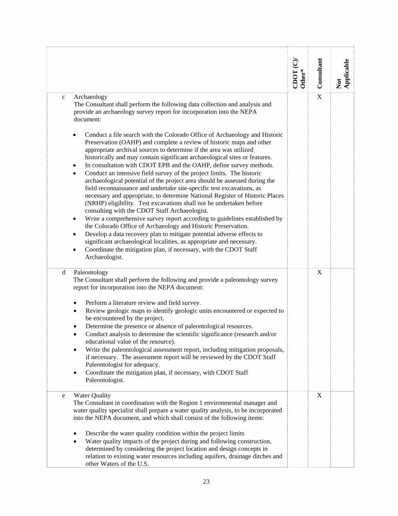
c Archaeology The Consultant shall perform the following data collection and analysis and provide an archaeology survey report for incorporation into the NEPA document: Conduct a file search with the Colorado Office of Archaeology and Historic
Preservation (OAHP) and complete a review of historic maps and other appropriate archival sources to determine if the area was utilized historically and may contain significant archaeological sites or features.
In consultation with CDOT EPB and the OAHP, define survey methods. Conduct an intensive field survey of the project limits. The historic
archaeological potential of the project area should be assessed during the field reconnaissance and undertake site-specific test excavations, as necessary and appropriate, to determine National Register of Historic Places (NRHP) eligibility. Test excavations shall not be undertaken before consulting with the CDOT Staff Archaeologist.
Write a comprehensive survey report according to guidelines established by the Colorado Office of Archaeology and Historic Preservation.
Develop a data recovery plan to mitigate potential adverse effects to significant archaeological localities, as appropriate and necessary.
Coordinate the mitigation plan, if necessary, with the CDOT Staff Archaeologist.
X
d Paleontology The Consultant shall perform the following and provide a paleontology survey report for incorporation into the NEPA document:
Perform a literature review and field survey. Review geologic maps to identify geologic units encountered or expected to
be encountered by the project. Determine the presence or absence of paleontological resources. Conduct analysis to determine the scientific significance (research and/or
educational value of the resource). Write the paleontological assessment report, including mitigation proposals,
if necessary. The assessment report will be reviewed by the CDOT Staff Paleontologist for adequacy.
Coordinate the mitigation plan, if necessary, with CDOT Staff Paleontologist.
X
e Water Quality The Consultant in coordination with the Region 1 environmental manager and water quality specialist shall prepare a water quality analysis, to be incorporated into the NEPA document, and which shall consist of the following items:
Describe the water quality condition within the project limits Water quality impacts of the project during and following construction,
determined by considering the project location and design concepts in relation to existing water resources including aquifers, drainage ditches and other Waters of the U.S.
X

24
CD
OT
(C
)/
Oth
er*
Con
sult
ant
Not
A
pp
lica
ble
Municipally Separate Storm Sewer System (MS4) design and permitting issues.
Identify requirements (e.g. MS4) that may influence alternatives criteria A mitigation plan that includes erosion control measures. A determination of water quality monitoring requirements. A technical memorandum describing methodology, direct and cumulative
analysis and mitigation measures, as necessary. f Ecological Assessment (including wildlife and vegetation)
The following activities shall be performed and documented by the Consultant for incorporation into the NEPA document as necessary: Conduct necessary field surveys and identify species present in accordance
with FHWA TA 6640-8a. Identify impacts to non-threatened and non-endangered wildlife and
vegetation, and recommend mitigation. Identify noxious weeds and plot occurrences on a map. Prepare a noxious weed management plan as appropriate and necessary.
X
g Threatened and/or Endangered (T/E) Species The Consultant in coordination with the Region 1 environmental manager and T/E specialist will write letters for CDOT Staff Biologist’s signature to the Division of Wildlife, US Fish and Wildlife Service, and Colorado Natural Heritage Program requesting Threatened and/or Endangered Species list. The following activities shall be performed and documented by the Consultant in coordination with the Region 1 specialist as necessary: Conduct a literature review to identify the potential for existing T/E species
and habitat Coordinate with Region 1 environmental manager and T/E specialist, and
USFWS and CDOW to determine if surveys for T/E species will be required for this project.
Identify existing conditions and habitat Prepare the threatened and/or endangered species impact assessment per
requirements of Section 7 of the Endangered Species Act. Develop a T/E Mitigation Plan. Identify any impacts and develop a mitigation plan to conform to
requirements of the Migratory Bird Treaty Act.
X
25
CD
OT
(C
)/
Oth
er*
Con
sult
ant
Not
A
pp
lica
ble
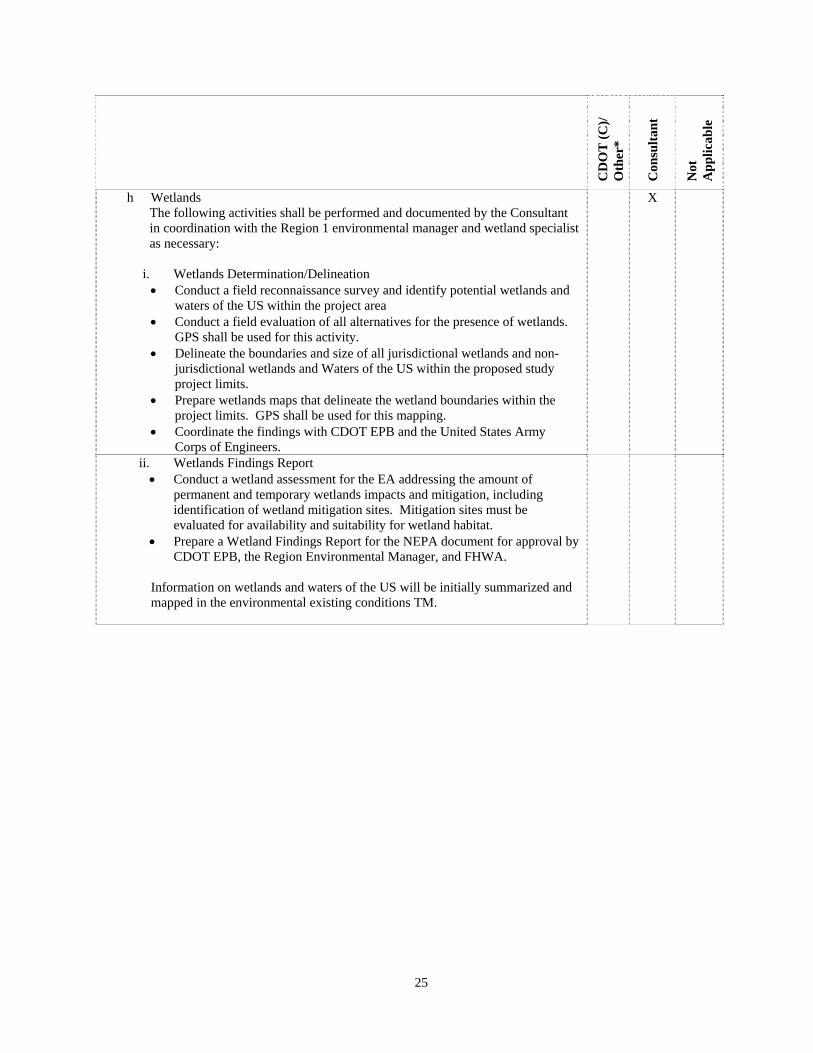
h Wetlands The following activities shall be performed and documented by the Consultant in coordination with the Region 1 environmental manager and wetland specialist as necessary:
i. Wetlands Determination/Delineation Conduct a field reconnaissance survey and identify potential wetlands and
waters of the US within the project area Conduct a field evaluation of all alternatives for the presence of wetlands.
GPS shall be used for this activity. Delineate the boundaries and size of all jurisdictional wetlands and non-
jurisdictional wetlands and Waters of the US within the proposed study project limits.
Prepare wetlands maps that delineate the wetland boundaries within the project limits. GPS shall be used for this mapping.
Coordinate the findings with CDOT EPB and the United States Army Corps of Engineers.
X
ii. Wetlands Findings Report Conduct a wetland assessment for the EA addressing the amount of
permanent and temporary wetlands impacts and mitigation, including identification of wetland mitigation sites. Mitigation sites must be evaluated for availability and suitability for wetland habitat.
Prepare a Wetland Findings Report for the NEPA document for approval by CDOT EPB, the Region Environmental Manager, and FHWA.
Information on wetlands and waters of the US will be initially summarized and mapped in the environmental existing conditions TM.
26
CD
OT
(C
)/
Oth
er*
Con
sult
ant
Not
A
pp
lica
ble
i Historic Resources (including Historic Bridges) The Consultant shall perform the following historic resources tasks and provide the survey report for incorporation into the NEPA document:
i. Historical Clearance Perform early and regular Section 106 consultation with CDOT staff
historian and State Historic Preservation Office (SHPO) to determine and refine and map the Area of Potential Effect (APE) as needed.
Perform an early reconnaissance survey of the study area for likely historic resources, and provide results to CDOT environmental manager, CDOT staff historian and SHPO. Potential resources include man-made structures, ditches, railroads, etc.
Conduct a literature and records search for previously recorded historic resources in the project corridor at the Office of Archaeology and Historic Preservation (OAHP).
Conduct an intensive architectural field survey of the project corridor and determine National Register of Historic Places (NRHP) eligibility for each resource 45 years or older.
Coordinate with the public and historic preservation groups in the project area (local historical societies or museums) concerning historic resources.
Write a comprehensive Historic Resources Survey Report (HRSR) according to guidelines established by the OAHP to submit for review by the CDOT staff historian.
Provide detailed survey forms with determination of eligibility and effects determination for submittal to the CDOT staff historian and the SHPO as soon as possible as design is fixed.
Prepare correspondence as necessary for CDOT staff historian to submit to the SHPO.
Develop a Memorandum of Agreement, if necessary, with recommended mitigation strategies for adverse effects for agency review and execution.
X
ii. Historical Bridge Clearance Assist CDOT to research the Colorado Bridge Survey to determine the
eligible or non-eligible status of bridges built before 1959 in the project area.
Prepare correspondence as necessary for the CDOT staff historian to submit to the State Historic Preservation Office (SHPO).
If bridges that have been determined to be eligible or listed on the National Register are present, develop alternatives to bridge replacement, including: No-Action, Rehabilitation, Build a Companion Structure, Build a New Bridge in a Different Location, and others dictated by the project circumstances.
Develop a Memorandum of Agreement, if necessary, to mitigate adverse impacts to historic bridges for agency review and execution.
Prepare historic recordation of the bridge to mitigate adverse effects according to standards established by OAHP if necessary.
27
CD
OT
(C
)/
Oth
er*
Con
sult
ant
Not
A
pp
lica
ble
j Floodplain and Drainage Assessment The following activities shall be performed by the Consultant in accordance with 23 CFR 650, Subpart A, Executive Order 11988, Floodplain Management, and DOT Order 5650.2 and documented in conjunction with any previously completed Urban Drainage and Flood Control District (UDFCD) studies: Coordinate with FEMA and Local Floodplain Administrator regarding
methodology for floodplain modeling. Determine the probable impacts of each alternative with respect to
floodplains and drainage. Identify adverse effects on the project area with respect to floodplains and
drainage for each alternative (including during construction and relative to actual operating conditions).
Develop possible mitigating actions for the adverse impacts and coordinate with roadway designers.
Analyze the impacts and mitigations. Included in the analysis shall be a determination of significant impacts due to:
Single community access routes. Significant risk for social or economic losses due to flooding. Alteration of beneficial floodplain values. The Consultant shall prepare a Floodplain and Drainage Assessment Report
which shall incorporate appropriate water quality control measures as per CDOT MS4 permit, New Highway Development program. The report will be reviewed by CDOT, and then finalized.
Prepare mapping of regulated (i.e. 100 year) floodplains.
X
k Right-of-way (ROW) The following activities shall be performed in accordance with the Uniform Relocation Assistance and Real Property Acquisition Policies Act of 1970 (P.L. 100- 17) and documented by the Consultant in accordance with Title 23, CFR 710:
i. Gather Data Perform a field inspection of each short-listed alternative. Ascertain
number of parcels, types of improvements, and possible problem areas (i.e., mobile homes, historical sites, etc.). Estimate family sizes for residential relocations.
Using local entity surveys, courthouse records, railroad right-of-way maps, real estate listings and other available sources, compile information on neighborhood characteristics, price ranges for land and improvements, housing availability, minority percentages, utility easement usage agreements, etc.
Compile a ROW acquisition and relocation cost estimate for each alternative.
Prepare a conceptual relocation plan. Identify potential problem areas. Prepare a property ownership map based on tax records, which identifies
ownerships for each alternative.
X
28
CD
OT
(C
)/
Oth
er*
Con
sult
ant
Not
A
pp
lica
ble
ii. Parcel Mapping Prepare land ownership mapping for parcels located one block off of the first row of properties along the project study area. Parcel information will include:
Type (residential, commercial, public, etc). Size and boundaries. Improvement (structures, etc.).
iii. ROW Review Review impacts on existing and known future land use. Prepare a ROW report, which summarizes the findings and includes:
o An acquisition cost estimate for each alternative. o A relocation evaluation and cost for each alternative. o Identified problem areas. o Ownership maps. o An estimate of the number of partial and total acquisitions required
for each alternative. o Easements for Utility relocations
The Consultant shall prepare a table identifying and listing all potentially affected properties including, at a minimum, ownership names, property and mailing addresses, estimated areas of impacts, and indicating which alternatives impact each property. This table shall be submitted to Region 1 Right of Way and may be included in the NEPA document. ROW information produced for the project’s engineering studies will require additional details that may also be used to supplement the early ROW information generated in support of the EA.
l Land Use
The Consultant shall prepare information on land use, including maps of existing and future land uses in order to:
i. Describe existing conditions in the project area.
ii. Describe land use impacts iii. Address potential cumulative effects iv. Prepare land use mapping, which identifies jurisdictional boundaries and
land uses in the project area including: Land in public ownership: specific use and responsible agency /
jurisdiction. Commercial: retail, wholesale, industrial, other commercial. Residential: single or multi family Vacant Mixed Use Other (specify)
X
29
CD
OT
(C
)/
Oth
er*
Con
sult
ant
Not
A
pp
lica
ble
m 4(f)/6(f) Activity
The following activities shall be performed and documented by the Consultant in accordance with the Land and Water Conservation Fund Act (Section 6(f)) 16. U.S.C. 460 - 4 to 460-1 1 (P.L. 88-578):
Determine if any Section 4(f) properties (e.g., publicly owned parks,
recreation, nationally significant historic sites, wildlife refuges) or Section 6(f) properties (e.g., have received Land and Water Conservation Funds) resources are likely to be present
Determine if any potential impacts or ROW acquisitions include Section 4(f) properties (e.g., publicly owned parks, recreation, nationally significant historic sites, wildlife refuges) or Section 6(f) properties (received Land and Water Conservation Funds).
Determine and evaluate project impacts on 4(f)/6(f) properties using preliminary design information, and the necessary commitments for mitigation measures. Prepare an analysis of avoidance, minimization, or mitigation alternatives considered for indirect or direct impacts to 4(f)/6(f) properties.
Prepare the documentation for 4(f)/6(f) clearance. This will go through the Region Environmental Manager to the EPB for review.
Prepare and coordinate determination with FHWA, State Parks and National Parks via the Region Environmental Manager and EPB.
X
n Hazardous Materials The following Initial Site Assessment (ISA) activities shall be performed and documented by the Consultant:
i. Gather Data.
Conduct a records review (through EDR database) of recorded environmental concerns or potential environmental concerns in the project area.
The EDR Report will be summarized and sites of known concern will be mapped to determine if hazardous sites will influence evaluation criteria for alternatives.
Conduct a field search of the proposed project area, after regulatory research is done.
The regulatory research should include researching the following sources: Lists compiled by EPA or Colorado Department of Public Health and Environment which identify: o Solid waste landfills. o Hazardous waste generators. o Hazardous waste treatment/storage/disposal facilities (current and
closed). o NPL sites. o Hazardous waste transporters. o CERCLIS sites.
X

30
CD
OT
(C
)/
Oth
er*
Con
sult
ant
Not
A
pp
lica
ble
o Locations of underground storage tanks. o Mining sites/oil wells. o Known, suspected, or abandoned hazardous waste sites.
Records kept by EPA or Colorado Department of Public Health and Environment on hazardous waste regulation violations or citations.
Lists kept by the appropriate fire department on: o Locations of “active” leaking underground storage tanks, and
closed leaking underground storage tanks. o Location of wells from the State Engineer’s office. o Underground storage tank locations. o HAZMAT incidents/accidents. o Local emergency planning/hazard materials use reporting.
Available historic tax records which indicate past land use (coordinate with property ownership and land use data research).
Available historic aerial photos of the corridor (e.g., USGS, ASCS, Public Library, etc.). Historic topographic maps.
Any pertinent records maintained by CDOT. Personal interviews. Agency file reviews.
ii. Conduct In-Situ Tests.
If necessary, the consultant shall select locations for soil boring or monitoring wells based on information obtained in ISA, geologic review, alignment considerations and consultation with Region 1 and EPB staff. Install monitoring wells and obtain soil and water samples for chemical analysis as well as geotechnical and geologic data, as directed by CDOT.
X
iii. Analyze and Assess Impacts.
Analyze results of chemical analyses and records review and identify potential impacts to the construction from hazardous waste. Assess potential hazards to the public and construction workers and develop potential mitigation options.
Prepare ISA Document: o Prepare the Draft and subsequent Final Initial Site Assessments
(ISAs). The draft document shall be reviewed by CDOT Region 1 and EPB.
o ISA’s shall conform to ASTM standards for Phase I reports, and make a determination of necessity of Phase II report.
o Search radii shall conform to CDOT requirements for the various databases researched.
X
31
CD
OT
(C
)/
Oth
er*
Con
sult
ant
Not
A
pp
lica
ble
o Existing Roadway Structures The Consultant shall analyze/investigate the following: Evaluate the existing conditions and assess the merits relative to the
following: Accident History Roadway and Structure Condition Lighting Roadway Traffic Signal Devices Geometry
X
p Construction Requirements The Consultant shall analyze/investigate the following: General construction impact (of temporary nature including detours and
maintaining access) Material Pits Haul Roads
X
q Visual/Aesthetic Considerations The Consultant shall prepare a Corridor Vision TM that details the visual context of the I-70 and Kipling St. interchange within the broader scope of I-70 and Kipling St. as regional highways within the City of Wheat Ridge. This brief TM (no more than 10 pages) will outline the aesthetic influences and provide the visual context and view sheds for the project area. The TM will discuss the existing visual environment and other projects that are influencing or have the potential to change the visual character of the corridor. When specified, the following shall be investigated:
i. Overall visual qualities of this project area.
ii. Photographs of key viewpoints. iii. Natural areas and trails. iv. Assess impacts and identify mitigation for construction and long-term
impacts.
X
r Utilities and Energy The effect of utilities energy shall be investigated for each alternative. The Consultant shall collect utility location key maps for all utilities in the area in coordination with CDOT Region 1 utilities specialist.
X
s Economics The Consultant shall investigate the existing conditions of commercial and industrial enterprises, employment, local tax base, regional earnings, etc. The Consultant shall investigate the direct and indirect effects of the project alternatives on commercial and industrial enterprises, employment, local tax base, regional earnings, etc. This shall be done at the regional and project level.
X
32
CD
OT
(C
)/
Oth
er*
Con
sult
ant
Not
A
pp
lica
ble
t Prime & Unique Farmlands In cooperation with the NRCS, the Consultant shall investigate and quantify as necessary the effect of the project alternatives on farmlands, particularly farmlands classified as “prime” or “unique.” US Department of Agriculture Form No. 1006 shall be completed as necessary.
X
u Social Considerations Working with the City of Wheat Ridge and the Stakeholders, the Consultant shall investigate and document the effects of the final alternatives on community cohesion, safety and security, neighborhood impacts, and accessibility of facilities and services.
X
v Environmental Justice The Consultant shall identify and address disproportionately high and adverse human health, social, and environmental effects on minority and low-income populations consistent with Executive Order 12898, and FHWA and EPA guidance. The Consultant shall collect the necessary data to identify existing low income and minority populations that could be affected by the proposed project, adverse effects, disproportionately high and adverse effects, and mitigation measures or alternatives that would avoid or reduce the impacts according CDOT Title VI and Environmental Justice Guidelines. Positive effects, if any, will also be identified. The analysis will reference other resources as appropriate (e.g. – noise, air and water pollution, aesthetics, community cohesion, relocation impacts, etc.). Data will be collected from US Census track and block group data in accordance with FHWA guidance The Consultant shall make efforts to reach out to local communities to ensure meaningful opportunities for public participation as defined in the Public Involvement Plan. The Consultant shall document the degree to which affected low income or minority populations have been involved in the decision-making process related to the alternatives’ selection, impact analysis, and mitigation development. The Consultant shall document the efforts which have been made to involve low-income or minority populations in the decision-making process related to the alternatives' selection, impact analysis, and mitigation development. The Consultant must be mindful that the necessary Environmental Justice evaluation may require more labor-intensive activities to obtain sufficient input from low-income and/or minority populations. The Consultant shall document all outreach efforts for low income and minority communities.
X
33
CD
OT
(C
)/
Oth
er*
Con
sult
ant
Not
A
pp
lica
ble
w Cumulative Impacts
Consistent with Council on Environmental Quality (CEQ) regulations, the cumulative effects of each proposed action on a resource, ecosystem or human community will be evaluated for each alternative. The analysis shall consider incremental impacts of each alternative in conjunction with all past, present, and reasonably foreseeable actions, no matter what entity (federal, non-federal, or private) is taking or has taken the action; but the analysis should only focus on meaningful effects. The scope of the analysis will be developed in consultation with FHWA and CDOT but, in general, temporal and spatial boundaries shall be based on the natural boundaries of resources of concern and the period of time that the proposed action’s impacts will persist. Additional guidance related to cumulative impacts is contained in a January 31, 2003 memorandum from FHWA entitled “Information: Interim Guidance: Questions and Answers Regarding Indirect and Cumulative Impact Considerations in the NEPA Process.” The Consultant shall define the geographic scope of cumulative impact analysis and identify a list of past, present, and reasonably foreseeable future projects that will be considered as part of the cumulative impact analysis for this project. The geographic scope of analysis for each resource area will be identified in coordination with agencies during scoping and preparation of the Environmental Methodology Report. The project list will be developed as part of agency and public scoping.
X
x Construction Estimates The Consultant shall prepare preliminary construction cost estimates of each reasonable alternative identified during the EA process. Enough detail shall be included to ensure a reasonable degree of accuracy for the level of design performed. The format of estimates shall be submitted to CDOT for review and approval.
X
F. Traffic Related a Travel Demand Forecasting
Develop traffic volumes using available traffic demand models; determine the design year during the scoping process for the project. The model expected to be used for this project is the 2035 model. Forecasts should be based on existing roadways and roadways that are committed to be constructed. Future traffic forecasts must be developed for the No-Action Alternative and any build alternatives. The results of the travel demand forecast process will be developed into a technical report.
X

34
CD
OT
(C
)/
Oth
er*
Con
sult
ant
Not
A
pp
lica
ble
b Traffic Operations
Analyze existing and future traffic operations analysis will be conducted for the No-Action Alternative and build alternatives. Analysis will be completed in accordance with the latest edition of the Highway Capacity Manual or similar methodology. In addition, the Consultant shall use a micro simulation software package (i.e. CORSIM, VISSIM, Dynasmart-P, or others as approved by CDOT) to evaluate the operations of the entire roadway network and report the appropriate measures of effectiveness for the alternatives. The selection of the software package for the required analyses will be depend on the size and other characteristics of the network, the alternatives to be analyzed, and the measures of interest. At a minimum, analysis will consider existing traffic volumes, accident history, percent of truck traffic, directional splits on all arterials, turning movements at intersections, interchange and ramp characteristics, travel/access patterns, level of service, delays, travel times and speeds, and areas of congestion. During the alternatives development and evaluation process, the appropriate level of operations analysis will also be conducted on the alternatives being considered. The results of the operations analysis are documented into a Transportation Technical Report.
X
c Safety Assessment Conduct safety analysis and document accident rates based on data collected from local emergency services, Colorado State Patrol, and CDOT Traffic Analysis Unit; obtain weighted hazard index from CDOT/PM; evaluate trends; document safety issues and how they can be addressed.
X
G. Visualization/3-D Modeling
As necessary, the Consultant shall develop rendered 3-D visualization models of the build alternatives for print and for presentation at agency and public meetings. Presentation models shall include fly-through and/or drive-through capability. Necessity for and extent of modeling shall be determined by the Consultant in coordination with CDOT.
X
35
SECTION 8 ENVIRONMENTAL ASSESSMENT WORK TASK DESCRIPTIONS
This list establishes the consultant’s individual task responsibility. The consultant shall maintain the ability to perform all work tasks which are indicated below by an ‘X’ in the consultant column, in accordance with the forms and conditions contained herein, and the applicable CDOT standards. Selected work tasks shall be assigned only after coordination and consultation with CDOT. The Consultant is also responsible for coordinating the required work schedule for those tasks accomplished by CDOT and other agencies. The Consultant should review this entire section to identify applicable material. Contact the Colorado Department of Transportation/Project Manager (CDOT/PM) if clarification is required (see Section 2.1, CDOT Contact). The following activities of communication, consensus building, project team reviews, conceptual design, data gathering, documentation, and formal public notice should be planned by the Consultant and coordinated with the CDOT/PM. The time of their accomplishment will overlap and parallel paths of activity should be planned to finish the development phase in accordance with the shortest possible schedule. The type and number of meetings, documents, etc., will depend on the category and characteristics of the project work. A project plan shall be developed by the Consultant which satisfies the requirements of the project development. This plan must be approved by the Contract Administrator (see Section 2.1, CDOT Contact) before starting the work.
CD
OT
(C
)/
Oth
er*
Con
sult
ant
Not
A
pp
lica
ble
1 ENVIRONMENTAL DOCUMENTATION The Consultant shall accomplish the following activities in accordance with the appropriate FHWA and CDOT procedures, subject to review by involved parties, and at the direction of CDOT Region 1.
A. Preliminary Data Submission
The Consultant shall provide CDOT with a summary environmental existing conditions TM report describing all the data collected for the resources listed above and detailing the preliminary data collected for the environmental resources to be analyzed in the EA.
X
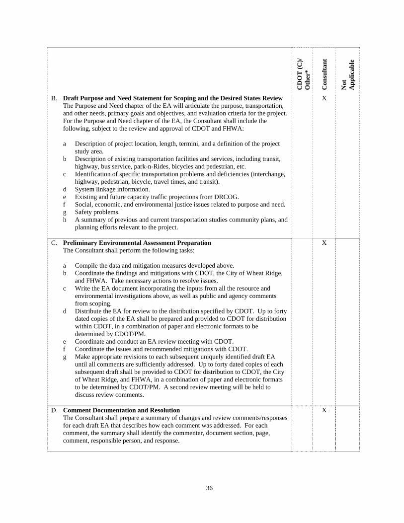
36
CD
OT
(C
)/
Oth
er*
Con
sult
ant
Not
A
pp
lica
ble
B. Draft Purpose and Need Statement for Scoping and the Desired States Review The Purpose and Need chapter of the EA will articulate the purpose, transportation, and other needs, primary goals and objectives, and evaluation criteria for the project. For the Purpose and Need chapter of the EA, the Consultant shall include the following, subject to the review and approval of CDOT and FHWA: a Description of project location, length, termini, and a definition of the project
study area. b Description of existing transportation facilities and services, including transit,
highway, bus service, park-n-Rides, bicycles and pedestrian, etc. c Identification of specific transportation problems and deficiencies (interchange,
highway, pedestrian, bicycle, travel times, and transit). d System linkage information. e Existing and future capacity traffic projections from DRCOG. f Social, economic, and environmental justice issues related to purpose and need. g Safety problems. h A summary of previous and current transportation studies community plans, and
planning efforts relevant to the project.
X
C. Preliminary Environmental Assessment Preparation The Consultant shall perform the following tasks: a Compile the data and mitigation measures developed above. b Coordinate the findings and mitigations with CDOT, the City of Wheat Ridge,
and FHWA. Take necessary actions to resolve issues. c Write the EA document incorporating the inputs from all the resource and
environmental investigations above, as well as public and agency comments from scoping.
d Distribute the EA for review to the distribution specified by CDOT. Up to forty dated copies of the EA shall be prepared and provided to CDOT for distribution within CDOT, in a combination of paper and electronic formats to be determined by CDOT/PM.
e Coordinate and conduct an EA review meeting with CDOT. f Coordinate the issues and recommended mitigations with CDOT. g Make appropriate revisions to each subsequent uniquely identified draft EA
until all comments are sufficiently addressed. Up to forty dated copies of each subsequent draft shall be provided to CDOT for distribution to CDOT, the City of Wheat Ridge, and FHWA, in a combination of paper and electronic formats to be determined by CDOT/PM. A second review meeting will be held to discuss review comments.
X
D. Comment Documentation and Resolution The Consultant shall prepare a summary of changes and review comments/responses for each draft EA that describes how each comment was addressed. For each comment, the summary shall identify the commenter, document section, page, comment, responsible person, and response.
X

37
CD
OT
(C
)/
Oth
er*
Con
sult
ant
Not
A
pp
lica
ble
E. Review and Concurrence The Consultant shall make revisions to the final EA. The resulting EA shall be provided to CDOT for distribution and final review, prior to preparing the signature copy. The Consultant shall submit the signature copy of the EA to CDOT for signatures and routing to FHWA for approval, and then shall provide copies of the signed Final Draft EA to CDOT (up to 40 copies are assumed).The Consultant shall also provide an electronic version of the Final Draft EA on compact disk(s).
X
F. Public Document Availability and Advertisement The Consultant shall provide the following services:
a Arrange for the public notice of availability. b Provide the opportunity for public review of the Final Draft EA. c Compile public comments. d Provide an electronic version of the EA on the CDOT website in read only
format.
X
G. Public Hearing The Consultant shall provide the following services
a Advertise the public hearing date and location. b Prepare the graphic presentation to include, at a minimum, the following
features: o Need for project o Maps showing alternative alignments o Description of significant social, environmental and economic impacts o Design features o Consistency with federal and local plans o Timetable for right-of-way acquisition and construction o Source and amount of funding
c Present mitigating measures d ROW information e Prepare a certified transcript of the public hearing.
X

38
CD
OT
(C
)/
Oth
er*
Con
sult
ant
Not
A
pp
lica
ble
H. Finding of No Significant Impact (FONSI) Preparation
[NOTE: If significant impacts are identified in the EA, the process will continue to the preparation of an Environmental Impact Statement (EIS) rather than to a FONSI. Preparation of an EIS is not part of this Scope of Work, although, at CDOT’s sole discretion this Scope of Work can be amended to include the features of an EIS, in the event that an EIS becomes necessary.]
The Consultant shall provide the following services:
a Prepare draft FONSI. The scope assumes that minimal comments are received
at the public hearing or after the EA is out for public review. b Submit draft FONSI for review. c Coordinate and conduct a draft FONSI review meeting and modify the draft
FONSI to respond to comments received. d Submit final FONSI for signature. Make 40 copies of final FONSI. e Submit the FONSI to CDOT for signature and routing to FHWA for approval. f Provide an electronic version of the FONSI on compact disk(s).
X
I. Identify Permits The Consultant shall identify the need for permits and the information necessary to obtain the required permits, and shall also establish a schedule to obtain permits based on construction phasing and timing. The following is a non-exclusive list of such possible permits and permit processes:
a 401 Permit Process - Submit design information, including Best Management
Practices (BMPs), to the Colorado Department of Public Health and Environment (CDPHE) and determine need for 401 permit application submittal.
b 402 Permit Process - Submit design information to the CDPHE and determine need for 402 permit application submittal.
c 404 Permit Process - Submit design information to the United States Army Corps of Engineers and determine need for 404 permit application submittal.
d National Pollutant Discharge Elimination System (NPDES) Stormwater Permit for Construction Activities - Submit design information, including erosion control plans to the CDPHE and determine need for NPDES permit application submittal.
e CDOT Access Permit - Submit design information to CDOT and determine need for CDOT access permit application submittal.
f Railroad permits – Identify need for any required permits and submit necessary information to appropriate railroad(s).
g SB40 Permit h Others, as necessary.
X

39
SECTION 9 PRELIMINARY SURVEY
This list establishes the consultant’s individual task responsibility. The consultant shall maintain the ability to perform all work tasks which are indicated below by an ‘X’ in the consultant column, in accordance with the forms and conditions contained herein, and the applicable CDOT standards. Selected work tasks shall be assigned only after coordination and consultation with CDOT. The Consultant is also responsible for coordinating the required work schedule for those tasks accomplished by CDOT and other agencies. The Consultant should review this entire section to identify applicable material. Contact the Colorado Department of Transportation/Project Manager (CDOT/PM) if clarification is required (see Section 2.1, CDOT Contact). The following activities of communication, consensus building, project team reviews, conceptual design, data gathering, documentation, and formal public notice should be planned by the Consultant and coordinated with the CDOT/PM. The time of their accomplishment will overlap and parallel paths of activity should be planned to finish the development phase in accordance with the shortest possible schedule. The type and number of meetings, documents, etc., will depend on the category and characteristics of the project work. A project plan shall be developed by the Consultant which satisfies the requirements of the project development. This plan must be approved by the Contract Administrator (see Section 2.1, CDOT Contact) before starting the work.
CD
OT
(C
)/
Oth
er*
Con
sult
ant
Not
A
pp
lica
ble
1 PRELIMINARY SURVEY It is anticipated that survey for this project will be conducted by Consultant. The Consultant may be utilized for survey work on an on-call basis as needed. Surveys will be conducted in accordance with the CDOT Survey Manual, the latest addendum thereof, and applicable state statutes. The completed survey shall be reviewed by the Region survey unit. Two weeks should be provided in the schedule to complete the review and sufficient time should be provided to address all comments provided by this review. Design shall not proceed until all comments resulting from this review have been satisfactorily addressed.
A. Presurvey Conference A presurvey conference shall be held as per CDOT Survey Manual. The consultant shall attend the Presurvey conference prior to any right of way or survey work
X
B. Survey Data Research Research shall be done as per CDOT Survey Manual and the CDOT Right-of-Way Manual.
X
C. Secure Rights of Entry Follow procedures in the CDOT Survey Manual.
X

40
CD
OT
(C
)/
Oth
er*
Con
sult
ant
Not
A
pp
lica
ble
D. Project Control Survey a Locate or Establish HARN Stations
Project control shall be tied to the nearest Colorado High Accuracy Reference Network Station (HARN). In the event there are no HARN stations within 3 miles of the project (Order B, 1:1,000,000 accuracy), or HARN Densification (Order B-2, 1:500,000 accuracy), additional HARN Densification stations shall be set. NGS Blue Book procedures shall be followed for all HARN Densification stations. This will include proper spacing using proper monumentation, equipment, observation procedures, coordination through the Colorado State Geodetic Advisor and submission to NGS for inclusion in the National Database.
X
b Monumentation Materials will be supplied by CDOT care is to be taken to install said monumentation in locations that are readily usable for the project and in a safe location so that they can be utilized throughout construction (no monumentation shall be set on or near the centerline of the proposed roadway).
X
c Local Project Control Survey the required project control (centerline/baselines and elevation reference) as required. Prepare a control survey diagram showing graphical representation of all monuments used for control. Tabulate coordinates and physical descriptions of all found monuments and other physical evidence.
X
E. Land Survey/Boundary Survey Tie aliquot, property and other land monuments to the control survey. Prepare a Land Survey Control Diagram showing graphical representation of all found aliquot, property and land monuments and their relationship to the project control. Tabulate the coordinates and physical description of all found monuments and other physical evidence.
X
F. TMOSS (Topographic) Survey Collect the data required to produce a planimetric map and submit in TMOSS format. Features located will include, but not be limited to signs, mailboxes, fences, driveways, curb cuts, curbs, sidewalks, and edges of pavements. Horizontal accuracy shall be as specified in the CDOT Survey Manual for a CDOT class C or D TMOSS survey.
X
G. Terrain (Relief or Elevation) Survey Collect elevation data and submit in TMOSS format. Natural ground elevations shall be as specified in the CDOT Survey Manual.
X
H. Utility Survey Locate utility poles, manholes, valves, pedestals, guy wires, and other visible utility features. Survey underground utilities as marked by the utility companies. Determine invert elevations of manholes and vaults and survey the locations of utilities exposed by “potholing”.
X

41
CD
OT
(C
)/
Oth
er*
Con
sult
ant
Not
A
pp
lica
ble
I. Hydraulic Survey Locate culverts, storm sewer pipes, inlets, vaults, manholes and determine invert elevations. Locate inlets and determine invert elevation of pipes. Accomplish drainage situation surveys for designated culverts and bridges.
X
J. Material Sources Survey designated material sources as specified.
X
K. Supplemental Surveying: As required and specifically requested.
X
L. Survey Report Prepare a Survey Report as required in the Survey Manual.
X
M. Photogrammetry a Camera Calibration Report b Flight Plan c Flight d Contact Prints e Negatives f Enlargements g Photo Index h Supplemental Survey (wing points) i Data Reduction
Topographic Contours Planimetric (Topography)
j Map Compilation Index Maps Finished Maps
X
N. Accuracy Tests Tests are to be performed on a regular basis throughout the project by the consultant.
X
O. Review by Professional Land Surveyor The accuracy tests are to be reviewed by the PLS in responsible charge for the project, and submitted to the project engineer and made part of the project records. Further review of all aspects of the field and office work shall also be the responsibility of the PLS in responsible charge.
X
Note: The completed survey shall be reviewed by the Region survey unit. Two weeks should be provided in the schedule
to complete the review and sufficient time should be provided to address all comments provided by this review. Design shall not proceed until all comments resulting from this review have been satisfactorily addressed.
42
SECTION 10 DESIGN WORK TASK DESCRIPTION
Once the Environmental Phase is completed the Consultant will develop an advertisement set of plans and specifications for the alternative selected by the NEPA process by performing the following tasks. This list establishes the consultant’s individual task responsibility. The consultant shall maintain the ability to perform all work tasks which are indicated below by an ‘X’ in the consultant column, in accordance with the forms and conditions contained herein, and the applicable CDOT standards. Selected work tasks shall be assigned only after coordination and consultation with CDOT. The Consultant is also responsible for coordinating the required work schedule for those tasks accomplished by CDOT and other agencies. The Consultant should review this entire section to identify applicable material. Contact the Colorado Department of Transportation/Project Manager (CDOT/PM) if clarification is required (see Section 2.1, CDOT Contact). The following activities of communication, consensus building, project team reviews, conceptual design, data gathering, documentation, and formal public notice should be planned by the Consultant and coordinated with the CDOT/PM. The time of their accomplishment will overlap and parallel paths of activity should be planned to finish the development phase in accordance with the shortest possible schedule. The type and number of meetings, documents, etc., will depend on the category and characteristics of the project work. A project plan shall be developed by the Consultant which satisfies the requirements of the project development. This plan must be approved by the Contract Administrator (see Section 2.1, CDOT Contact) before starting the work.
Note: This section of the scope of work applies after the environmental clearance document and clearances have
been completed. The consultant will obtain and review the applicable environmental clearance documentation (Cat. Ex., EA, EIS) and ensure that all of the commitments within the document are implemented in the design package. This includes but is not limited to the following:
Noise, Air Quality, Alternate Modes, Archaeology, Paleontology, Hydraulics, Hydrology, Water Quality, Ecological Assessment, Historical, Floodplains, Wetlands, ROW, 4f/6f, As well as the following: Threatened and Endangered Species, Hazardous Materials, Traffic and Safety, Environmental Justice and cumulative and indirect impacts.
CD
OT
(C
)/
Oth
er*
Con
sult
ant
Not
A
pp
lica
ble
1 PRELIMINARY ENGINEERING
A. Traffic Engineering
a Review locations with “potential for accident reduction map” and or traffic operations analysis and or the safety assessment report as provided by CDOT to determine which safety improvements will be incorporated into the project.
X
b Analyze the proposed project design with the traffic projection data X c Recommend the appropriate geometry (i.e., number of lanes, auxiliary lanes,
storage lengths, weaving distances, etc.) in accordance with the current version of Highway Capacity Manual.
X
d The proposed design shall be reviewed to ensure compatibility with existing signing procedures throughout the preliminary roadway design process
X
e Use traffic data appropriate to the anticipated construction timing in developing detour alternatives.
X
f Develop the total ESAL for the design life and submit to the CDOT/PM for the pavement design.
X
g Submit the traffic data and recommendations to the CDOT/PM for review. X
43
CD
OT
(C
)/
Oth
er*
Con
sult
ant
Not
A
pp
lica
ble
B. Materials Engineering a Preliminary Soil Investigation
i Determine test hole locations (horizontal and vertical) and coordinate with the
CDOT/PM. ii Collect soil samples and test for:
A Classification B Moisture – Density Relationship C Resistance Value D Corrosiveness Note locations of high corrosiveness with recommendations E Bearing Capacity
iii Prepare and submit a soils investigation report.
X
C. Pavement a Pavement Rehabilitation
This section applies if the project includes existing pavement that is incorporated in the design for continued utilization.
X
i Determine the equivalent Design Traffic (18k ESAL) that the existing pavement can carry
ii Estimate the 18k ESAL’s experienced by the existing pavement. iii Obtain the projected 18k ESAL for rehabilitated pavement design period. iv Perform a distress survey
A Determine the types of distress present in the pavement B Determine the extent of each distress type C Develop a distress map for the existing pavement D Determine the causes of the existing distress utilizing tests and required
and analyses. E Determine the drainage conditions of the existing surface and subsurface
v Investigate the existing pavement structure A Subgrade: soil classifications, moisture/density relationship, resistance
value and corrosiveness B Base: thickness, gradation, plasticity index, liquid limit, resistance value,
strength coefficient C Pavement: thickness, strength coefficient
vi Perform deflection testing to obtain the following: A Deflection profile B Maximum deflection C Deflection basin D Differential deflections at transverse joints for portland cement concrete
pavement (pccp) E In place determination of the appropriate modulus for each layer and
subgrade
vii Determine the remaining load carrying capacity from the above data.
44
CD
OT
(C
)/
Oth
er*
Con
sult
ant
Not
A
pp
lica
ble
viii Design the feasible alternatives for the required rehabilitation (and widening if appropriate) utilizing the above investigations and test results. The design of the feasible alternatives shall be checked against the following: A The basic cause of distress which shall be corrected B Effect on the rate of future deterioration C Effect on surface characteristics Where appropriate, any new pavement widening shall be included in the analysis.
b New Pavement Structure The feasible alternatives of new pavement structure shall be designed utilizing procedures accepted by the CDOT/PM. New pavement designs for widening shall be compatible with adjacent rehabilitated existing pavement.
X
c Pavement Justification X i Basic factors:
A Desired life expectancy (obtain design life from CDOT). B Required maintenance activities intervals. C Basis for performance life.
ii Analyze life cycle cost of the selected alternatives A Perform analysis with unit and maintenance costs from CDOT. Determine
present worth and annual costs in accordance with the procedures in the CDOT Pavement Design Guide.
B Compare alternatives over the same life span. C Recommend the pavement structure and provide the basis for the
recommendations.
d Pavement Design Report Include all the above tests, investigations, analyses, and calculations performed as a result of this section. Submit to the CDOT/PM for acceptance.
X
D. Structures a Existing bridge condition investigation
Determine condition of existing bridge deck, superstructure and substructure material as required.
X
b Foundation Investigation Report X i Prepare a Foundation Investigation Request showing requested test hole
locations.
ii Formulate drilling pattern, perform the necessary subsurface investigation and collect samples as required.
iii Perform the appropriate laboratory tests and analyze the data. Determine strength, allowable bearing capacity and corrosiveness of foundation material.
iv Perform lateral analyses (deformation, moment, and shear) for the caissons and/or piles which are subjected to lateral loadings. This may be a computer analysis which will consider the group effect and selection of the soil parameters.
v If appropriate, a pile driving analysis using a wave equation will be accomplished.
vi Submit the Foundation Investigation Report to the CDOT/PM for approval. vii Prepare engineering geology plan sheet and copies of the Foundation
Investigation Report foundation report with recommendations for type, size, and tip (bottom) elevation of the required foundation. Specify if pre-drilling, pile tip, casing, dewatering, etc., are needed for foundation construction.
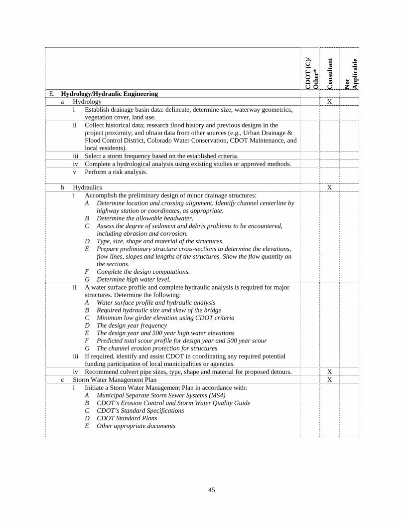
45
CD
OT
(C
)/
Oth
er*
Con
sult
ant
Not
A
pp
lica
ble
E. Hydrology/Hydraulic Engineering a Hydrology X
i Establish drainage basin data: delineate, determine size, waterway geometrics, vegetation cover, land use.
ii Collect historical data; research flood history and previous designs in the project proximity; and obtain data from other sources (e.g., Urban Drainage & Flood Control District, Colorado Water Conservation, CDOT Maintenance, and local residents).
iii Select a storm frequency based on the established criteria. iv Complete a hydrological analysis using existing studies or approved methods. v Perform a risk analysis.
b Hydraulics X i Accomplish the preliminary design of minor drainage structures:
A Determine location and crossing alignment. Identify channel centerline by highway station or coordinates, as appropriate.
B Determine the allowable headwater. C Assess the degree of sediment and debris problems to be encountered,
including abrasion and corrosion. D Type, size, shape and material of the structures. E Prepare preliminary structure cross-sections to determine the elevations,
flow lines, slopes and lengths of the structures. Show the flow quantity on the sections.
F Complete the design computations. G Determine high water level.
ii A water surface profile and complete hydraulic analysis is required for major structures. Determine the following: A Water surface profile and hydraulic analysis B Required hydraulic size and skew of the bridge C Minimum low girder elevation using CDOT criteria D The design year frequency E The design year and 500 year high water elevations F Predicted total scour profile for design year and 500 year scour G The channel erosion protection for structures
iii If required, identify and assist CDOT in coordinating any required potential funding participation of local municipalities or agencies.
iv Recommend culvert pipe sizes, type, shape and material for proposed detours. X c Storm Water Management Plan X
i Initiate a Storm Water Management Plan in accordance with: A Municipal Separate Storm Sewer Systems (MS4) B CDOT’s Erosion Control and Storm Water Quality Guide C CDOT’s Standard Specifications D CDOT Standard Plans E Other appropriate documents
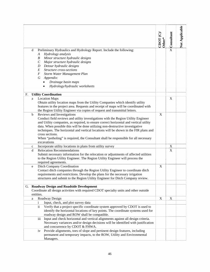
46
CD
OT
(C
)/
Oth
er*
Con
sult
ant
Not
Ap
pli
cab
le
d Preliminary Hydraulics and Hydrology Report. Include the following: A Hydrology analysis B Minor structure hydraulic designs C Major structure hydraulic designs D Detour hydraulic designs E Structure cross-sections F Storm Water Management Plan G Appendix:
Drainage basin maps Hydrology/hydraulic worksheets
X
F. Utility Coordination
a Location Maps Obtain utility location maps from the Utility Companies which identify utility features in the project area. Requests and receipt of maps will be coordinated with the Region Utility Engineer via copies of request and transmittal letters.
X
b Reviews and Investigations Conduct field reviews and utility investigations with the Region Utility Engineer and Utility companies, as required, to ensure correct horizontal and vertical utility data. When possible this will be done utilizing non-destructive investigative techniques. The horizontal and vertical locations will be shown in the FIR plans and cross sections. When “potholing” is required, the Consultant shall be responsible for all necessary excavations
X
c Incorporate utility locations in plans from utility survey X d Relocation Recommendations
Submit necessary information for the relocation or adjustments of affected utilities to the Region Utility Engineer. The Region Utility Engineer will process the required agreements.
X
e Ditch Company Coordination Contact ditch companies through the Region Utility Engineer to coordinate ditch requirements and restrictions. Develop the plans for the necessary irrigation structures and submit to the Region Utility Engineer for Ditch Company review.
X
G. Roadway Design and Roadside Development
Coordinate all design activities with required CDOT specialty units and other outside entities.
a Roadway Design X X i Input, check, and plot survey data ii Verify that a project specific coordinate system approved by CDOT is used to
identify the horizontal locations of key points. The coordinate systems used for roadway design and ROW shall be compatible.
iii Input and check horizontal and vertical alignments against all design criteria. Necessary variances and/or design decisions will be identified with justification and concurrence by CDOT & FHWA.
iv Provide alignments, toes of slope and pertinent design features, including permanent and temporary impacts, to the ROW, Utility and Environmental Managers.
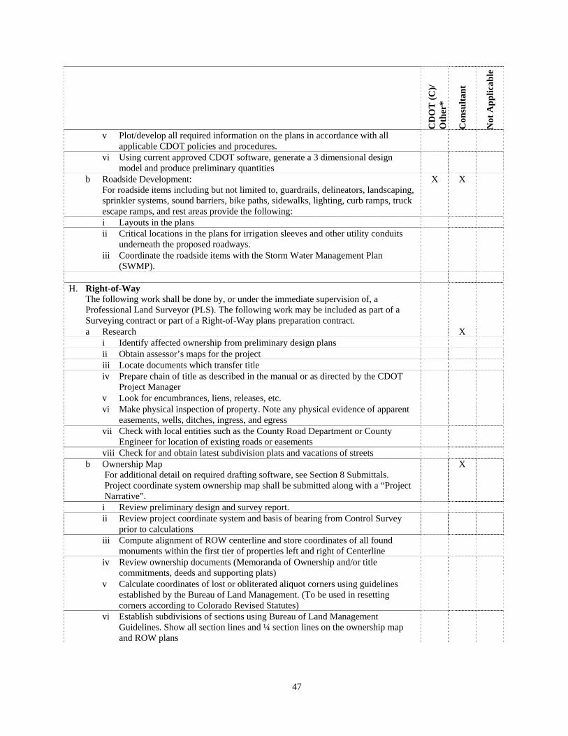
47
CD
OT
(C
)/
Oth
er*
Con
sult
ant
Not
Ap
pli
cab
le
v Plot/develop all required information on the plans in accordance with all applicable CDOT policies and procedures.
vi Using current approved CDOT software, generate a 3 dimensional design model and produce preliminary quantities
b Roadside Development: For roadside items including but not limited to, guardrails, delineators, landscaping, sprinkler systems, sound barriers, bike paths, sidewalks, lighting, curb ramps, truck escape ramps, and rest areas provide the following:
X X
i Layouts in the plans ii Critical locations in the plans for irrigation sleeves and other utility conduits
underneath the proposed roadways.
iii Coordinate the roadside items with the Storm Water Management Plan (SWMP).
H. Right-of-Way
The following work shall be done by, or under the immediate supervision of, a Professional Land Surveyor (PLS). The following work may be included as part of a Surveying contract or part of a Right-of-Way plans preparation contract.
a Research X i Identify affected ownership from preliminary design plans ii Obtain assessor’s maps for the project iii Locate documents which transfer title iv Prepare chain of title as described in the manual or as directed by the CDOT
Project Manager
v Look for encumbrances, liens, releases, etc. vi Make physical inspection of property. Note any physical evidence of apparent
easements, wells, ditches, ingress, and egress
vii Check with local entities such as the County Road Department or County Engineer for location of existing roads or easements
viii Check for and obtain latest subdivision plats and vacations of streets b Ownership Map
For additional detail on required drafting software, see Section 8 Submittals. Project coordinate system ownership map shall be submitted along with a “Project Narrative”.
X
i Review preliminary design and survey report. ii Review project coordinate system and basis of bearing from Control Survey
prior to calculations
iii Compute alignment of ROW centerline and store coordinates of all found monuments within the first tier of properties left and right of Centerline
iv Review ownership documents (Memoranda of Ownership and/or title commitments, deeds and supporting plats)
v Calculate coordinates of lost or obliterated aliquot corners using guidelines established by the Bureau of Land Management. (To be used in resetting corners according to Colorado Revised Statutes)
vi Establish subdivisions of sections using Bureau of Land Management Guidelines. Show all section lines and ¼ section lines on the ownership map and ROW plans

48
CD
OT
(C
)/
Oth
er*
Con
sult
ant
Not
Ap
pli
cab
le
vii Determine existing Right-of-Way limits from deeds of record, CDOT plans and found ROW markers. Previous Right-of-Way plans, if available, will be provided by CDOT as an aid
viii Determine ownerships and their property boundary locations. Locate the intersection of these property boundary lines with the existing CDOT Right-of-Way. Determine location and ownership of existing easements of record.
ix Secure additional property ties and additional topography where the highway improvement may affect improvements adjacent to the Right-of-Way. This additional topography should include: A Proximate buildings, sheds, etc. B Underground cables and conduits C Wells D Irrigation ditches and systems E Septic tanks, cesspools, and leaching fields F Landscaping G Other
x Reconcile overlaps and gaps in ownerships as required by CDOT, documenting method used (may require additional field work). Include reasons for decisions in the “Project Narrative”.
xi Plot OWNERSHIP MAP. If entire ownership will not fit on the sheet at this scale, an additional abbreviated OWNERSHIP MAP may be used at a scale of 1”=1 mile, or other suitable scale, to show the configuration of large ownerships. Metric equivalents may be required.
xii Label all monuments found with description of monument and project coordinates (from Control Survey Diagram)
xiii Show improvements and topography within the ownerships and existing access to the street/county road system.
xiv Number ownerships alternately as they occur along the centerline from south to north or west to east in the same direction as the stationing. Show current names of owners and lessees
xv Calculate the total area of all ownerships affected, including coordinates of all property corners. Deduct areas for existing road Rights-of-Way. Bearings and distances do not need to be shown on 1” = 1 mile abbreviated OWNERSHIP MAPS
xvi Different land uses within a property should be cross-hatched or shaded. xvii In the lower right corner of the OWNERSHIP MAP, show seal, number and
name of Professional Land Surveyor supervising the work
xviii Transmit finished reproducible OWNERSHIP MAP, electronic drawing files, and Memoranda of Ownership to CDOT along with all calculations, field notes, and supporting data. The OWNERSHIP MAP will include a copy of the control and monumentation sheet

49
CD
OT
(C
)/
Oth
er*
Con
sult
ant
Not
Ap
pli
cab
le
I. Major Structural Design Major structures are bridges and culverts with a total length greater than twenty feet or retaining walls with a total length greater than one hundred feet and a maximum exposed height at any section of over five feet. This length is measured along centerline of roadway for bridges and culverts, and along the top of wall for retaining walls. Overhead sign structures (sign bridges, cantilevers, and butterflies extending over traffic) are also major structures, but are exempt from the structure preliminary design activity defined here. The CDOT Structure Reviewer will participate in coordinating this activity.
a Structural Data Collection X i Obtain the structure site data. The following data, as applicable, shall be
collected: (Typical roadway section, roadway plan and profile sheets showing all alignment data, topography, utilities, preliminary design plan) Right-of-Way restrictions, preliminary hydraulics and geology information, environmental constraints, lighting requirements, guardrail types, recommendations for structure type, and architectural recommendations.
ii Obtain data on existing structures. When applicable, collect items such as existing plans, inspection reports, structure ratings, foundation information, and shop drawings. A field investigation of existing structures will be made with notification to the Resident Engineer.
b Structure Selection and Layout X i Review the structure site data to determine the requirements that will control
the structure size, layout, type, and rehabilitation alternatives. On a continuing basis, provide support data and recommendations as necessary to finalize the structure site data.
ii Determine the structure layout alternatives. For bridges, determine the structure length, width, and span configurations that satisfy all horizontal and vertical clearance criteria. For walls, determine the necessary top and bottom of wall profiles.
iii Determine the structure type alternatives. For bridges, consider precast and cast-in-place concrete and steel superstructures and determine the spans and depths for each. For walls, determine the feasible wall types.
iv Determine the foundation alternatives. Consider piles, drilled caissons, spread footings, and mechanically stabilized earth foundations based on geology information from existing structures and early estimates from the project geologist. To obtain supporting information, initiate the foundation investigation as early as possible during the preliminary design phase.
v Determine the rehabilitation alternatives. Continued use of all or parts of existing structures shall be considered as applicable. The condition of existing structures shall be investigated and reported. Determine the modifications and rehabilitation necessary to use all or parts of existing structures and the associated costs.
vi Develop the staged construction phasing plan, as necessary for traffic control and detours, in conjunction with the parties performing the roadway design and traffic control plan. The impact of staged construction on the structure alternatives shall be considered and reported on.
vii Compute preliminary quantities and preliminary cost estimates as necessary to evaluate and compare the structure layout, type, and rehabilitation alternatives.

50
CD
OT
(C
)/
Oth
er*
Con
sult
ant
Not
Ap
pli
cab
le
viii Evaluate the structure alternatives. Establish the criteria for evaluating and comparing the structure alternatives that, in addition to cost, encompass all aspects of the project’s objectives. Based on these criteria, select the optimum structure layout, type, and rehabilitation alternative, as applicable, for recommendation to CDOT.
ix Prepare preliminary general layout for the recommended structure. Prepare structure layouts in accordance with current standards. Special detail drawings and a detailed preliminary cost estimate shall accompany the general layout. The special detail drawings shall include the architectural treatment. Perform an independent design and detail check of the general layout.
c Structure Selection Report Prepare a structure selection report to document, and obtain approval for, the structure preliminary design. By means of the structure general layout, with supporting drawings, tables, and discussion, provide for the following:
X
i Summarize the structure site data used to select and layout the structures. Include the following: A Existing structure data, including sufficiency rating and whether or not the
structure is on the “select list”. B Project site plan C Roadway vertical and horizontal alignments and cross sections at the
structure D Construction phasing E Utilities on, below, and adjacent to the structure F Hydraulics: Channel size and skew, design year frequency, minimum low girder
elevation, design year and 500 year high water elevations, estimated design year and 500 year scour profiles, and channel erosion protection
G Preliminary geology information for structure foundation H Architectural requirements
ii Report on the structure selection and layout process. Include the following: A Discuss the structure layout, type, and rehabilitation alternatives
considered B Define the criteria used to evaluate the structure alternatives and how the
recommended structure was selected C Provide a detailed preliminary cost estimate and general layout of the
recommended structure
iii Obtain acceptance by CDOT on the recommended structure and its layout. Allow approximately two weeks for review of the structure selection report. The associated general layout, with the revisions required by the CDOT review, will be included in the FIR plans. The structure selection report, with the associated general layout, must be accepted in writing by CDOT prior to the commencement of further design activities.
d Foundation Investigation Request Initiate the foundation investigation as early in the preliminary design phase as is practical. On plan sheets showing the project control line, its stations and coordinates, utilities, identify the test holes needed and submit them to the project geologist. The available general layout information for the new structure shall be included in the investigation request.
X
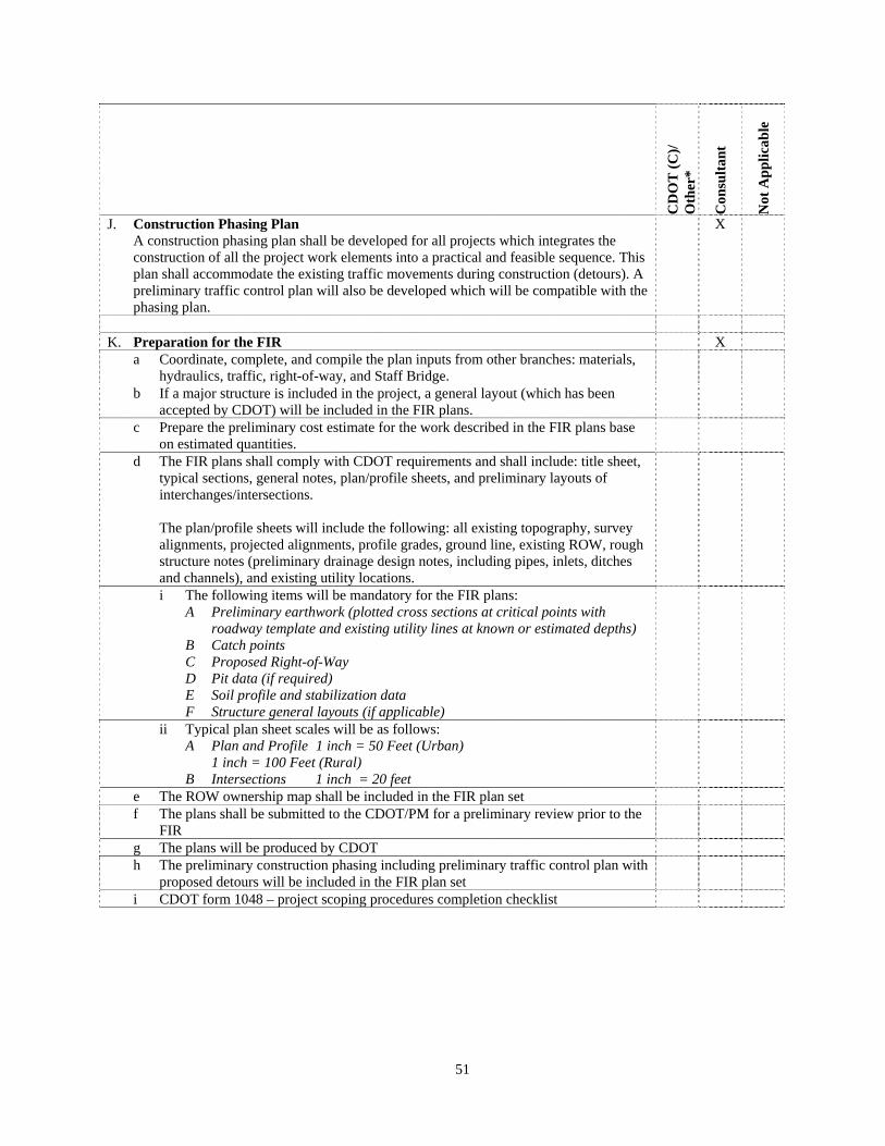
51
CD
OT
(C
)/
Oth
er*
Con
sult
ant
Not
Ap
pli
cab
le
J. Construction Phasing Plan A construction phasing plan shall be developed for all projects which integrates the construction of all the project work elements into a practical and feasible sequence. This plan shall accommodate the existing traffic movements during construction (detours). A preliminary traffic control plan will also be developed which will be compatible with the phasing plan.
X
K. Preparation for the FIR X
a Coordinate, complete, and compile the plan inputs from other branches: materials, hydraulics, traffic, right-of-way, and Staff Bridge.
b If a major structure is included in the project, a general layout (which has been accepted by CDOT) will be included in the FIR plans.
c Prepare the preliminary cost estimate for the work described in the FIR plans base on estimated quantities.
d The FIR plans shall comply with CDOT requirements and shall include: title sheet, typical sections, general notes, plan/profile sheets, and preliminary layouts of interchanges/intersections.
The plan/profile sheets will include the following: all existing topography, survey alignments, projected alignments, profile grades, ground line, existing ROW, rough structure notes (preliminary drainage design notes, including pipes, inlets, ditches and channels), and existing utility locations.
i The following items will be mandatory for the FIR plans: A Preliminary earthwork (plotted cross sections at critical points with
roadway template and existing utility lines at known or estimated depths) B Catch points C Proposed Right-of-Way D Pit data (if required) E Soil profile and stabilization data F Structure general layouts (if applicable)
ii Typical plan sheet scales will be as follows: A Plan and Profile 1 inch = 50 Feet (Urban) 1 inch = 100 Feet (Rural) B Intersections 1 inch = 20 feet
e The ROW ownership map shall be included in the FIR plan set f The plans shall be submitted to the CDOT/PM for a preliminary review prior to the
FIR
g The plans will be produced by CDOT h The preliminary construction phasing including preliminary traffic control plan with
proposed detours will be included in the FIR plan set
i CDOT form 1048 – project scoping procedures completion checklist

52
SECTION 11 CONTRACT CONCLUSION (CHECKLIST)
1 SUPPLEMENTAL WORK
It is anticipated that this contract may be supplemented for additional study and/or design efforts above any assumed quantities noted in the current contract scope. Additional efforts will require CDOT approval prior to beginning any work efforts.
2 CONTRACT COMPLETION This Contract will be satisfied upon acceptance of the following items if applicable: 1. Periodic Reports
2. Billings
3. Meeting Minutes
4. Project Management Plan
5. Project Schedule
6. Completed Specific Design Criteria
7. Survey Plan
8. Approved MHT’s
9. Permissions to Enter
10. Initial Submittal of TMOSS and/or MOSS Compatible Data
11. Initial Submittal of an Original Plan Sheet
12. Route Location Survey
13. Survey data in raw, unedited formats
14. Access report
15. Electronic Survey Files
16. Aerial Photography Index Map Sheets
17. Aerial Photography Contact Sheets
18. Public Involvement Plan
19. Public Communication Contact List Database
20. Newsletters
21. Project Hotline
22. Meeting Notices
23. Notice of Availability
24. Press Releases
25. Scoping Packet
26. Meeting Graphics and Displays
27. Meeting Materials
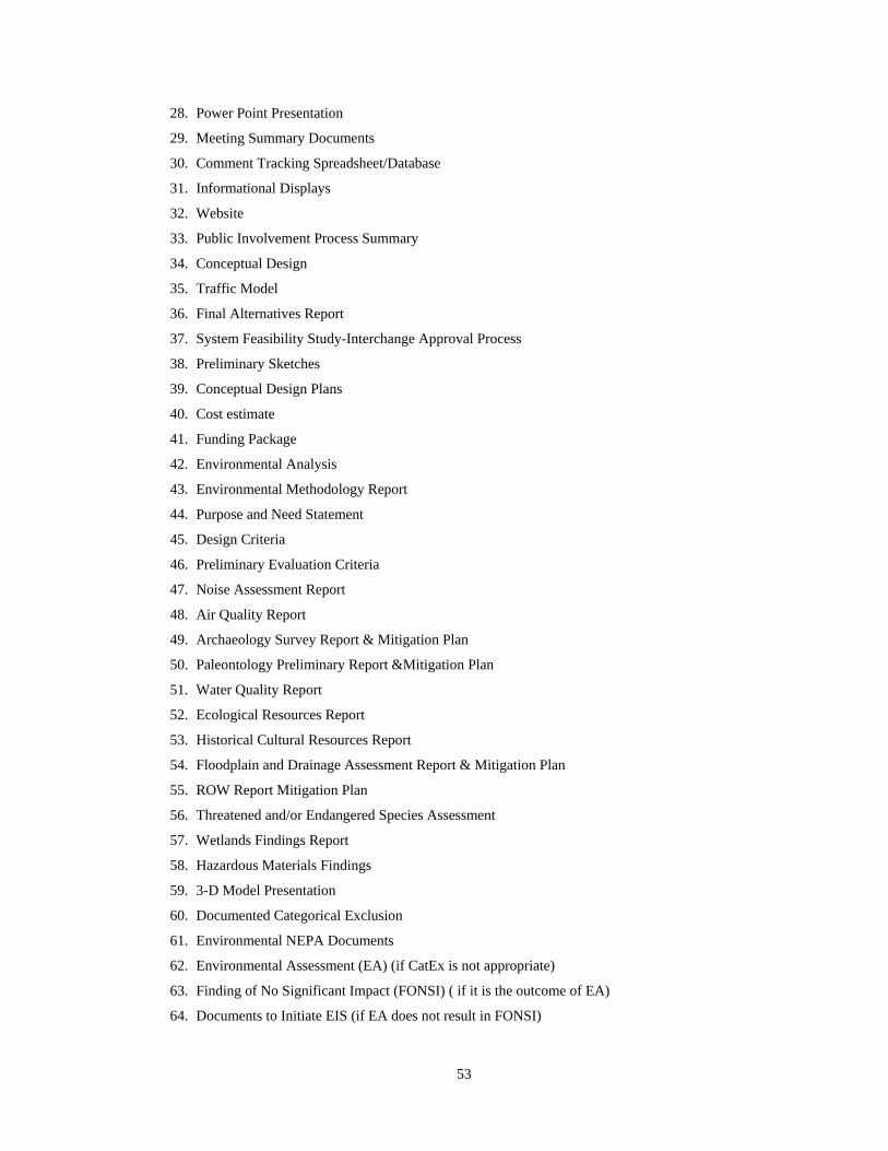
53
28. Power Point Presentation
29. Meeting Summary Documents
30. Comment Tracking Spreadsheet/Database
31. Informational Displays
32. Website
33. Public Involvement Process Summary
34. Conceptual Design
35. Traffic Model
36. Final Alternatives Report
37. System Feasibility Study-Interchange Approval Process
38. Preliminary Sketches
39. Conceptual Design Plans
40. Cost estimate
41. Funding Package
42. Environmental Analysis
43. Environmental Methodology Report
44. Purpose and Need Statement
45. Design Criteria
46. Preliminary Evaluation Criteria
47. Noise Assessment Report
48. Air Quality Report
49. Archaeology Survey Report & Mitigation Plan
50. Paleontology Preliminary Report &Mitigation Plan
51. Water Quality Report
52. Ecological Resources Report
53. Historical Cultural Resources Report
54. Floodplain and Drainage Assessment Report & Mitigation Plan
55. ROW Report Mitigation Plan
56. Threatened and/or Endangered Species Assessment
57. Wetlands Findings Report
58. Hazardous Materials Findings
59. 3-D Model Presentation
60. Documented Categorical Exclusion
61. Environmental NEPA Documents
62. Environmental Assessment (EA) (if CatEx is not appropriate)
63. Finding of No Significant Impact (FONSI) ( if it is the outcome of EA)
64. Documents to Initiate EIS (if EA does not result in FONSI)
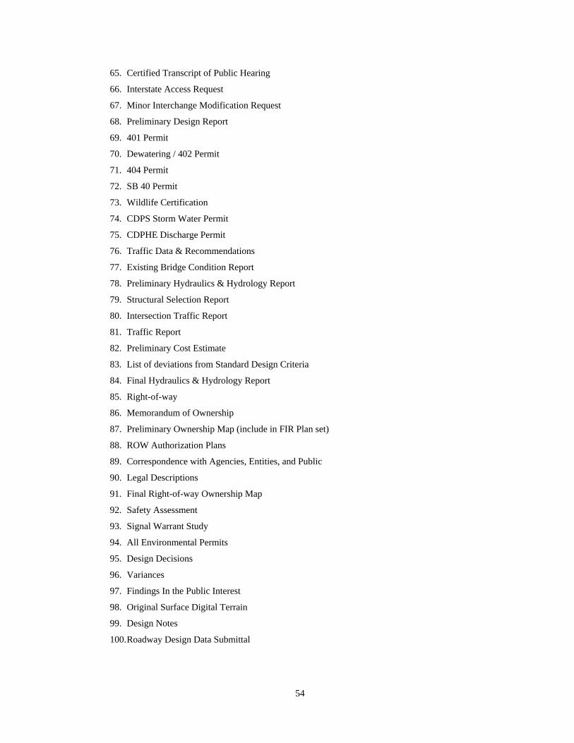
54
65. Certified Transcript of Public Hearing
66. Interstate Access Request
67. Minor Interchange Modification Request
68. Preliminary Design Report
69. 401 Permit
70. Dewatering / 402 Permit
71. 404 Permit
72. SB 40 Permit
73. Wildlife Certification
74. CDPS Storm Water Permit
75. CDPHE Discharge Permit
76. Traffic Data & Recommendations
77. Existing Bridge Condition Report
78. Preliminary Hydraulics & Hydrology Report
79. Structural Selection Report
80. Intersection Traffic Report
81. Traffic Report
82. Preliminary Cost Estimate
83. List of deviations from Standard Design Criteria
84. Final Hydraulics & Hydrology Report
85. Right-of-way
86. Memorandum of Ownership
87. Preliminary Ownership Map (include in FIR Plan set)
88. ROW Authorization Plans
89. Correspondence with Agencies, Entities, and Public
90. Legal Descriptions
91. Final Right-of-way Ownership Map
92. Safety Assessment
93. Signal Warrant Study
94. All Environmental Permits
95. Design Decisions
96. Variances
97. Findings In the Public Interest
98. Original Surface Digital Terrain
99. Design Notes
100. Roadway Design Data Submittal

February 19, 2016
55
APPENDICES
A. REFERENCES
B. SPECIFIC DESIGN CRITERIA
C. DEFINITIONS
Comments regarding this scope may be directed to:
Maggie Molinas
CDOT Agreements Office,
(303) 757-9398
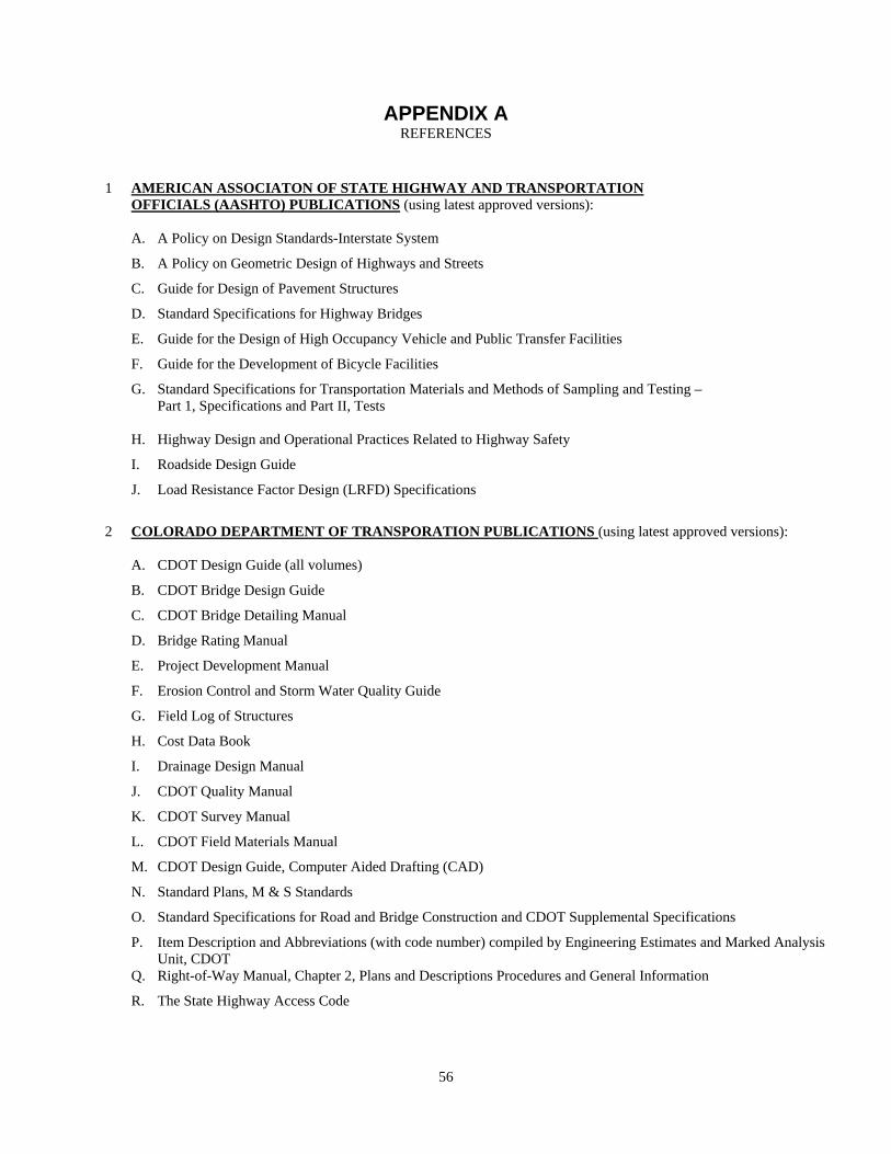
56
APPENDIX A REFERENCES
1 AMERICAN ASSOCIATON OF STATE HIGHWAY AND TRANSPORTATION OFFICIALS (AASHTO) PUBLICATIONS (using latest approved versions): A. A Policy on Design Standards-Interstate System
B. A Policy on Geometric Design of Highways and Streets
C. Guide for Design of Pavement Structures
D. Standard Specifications for Highway Bridges
E. Guide for the Design of High Occupancy Vehicle and Public Transfer Facilities
F. Guide for the Development of Bicycle Facilities
G. Standard Specifications for Transportation Materials and Methods of Sampling and Testing – Part 1, Specifications and Part II, Tests
H. Highway Design and Operational Practices Related to Highway Safety
I. Roadside Design Guide
J. Load Resistance Factor Design (LRFD) Specifications
2 COLORADO DEPARTMENT OF TRANSPORATION PUBLICATIONS (using latest approved versions):
A. CDOT Design Guide (all volumes)
B. CDOT Bridge Design Guide
C. CDOT Bridge Detailing Manual
D. Bridge Rating Manual
E. Project Development Manual
F. Erosion Control and Storm Water Quality Guide
G. Field Log of Structures
H. Cost Data Book
I. Drainage Design Manual
J. CDOT Quality Manual
K. CDOT Survey Manual
L. CDOT Field Materials Manual
M. CDOT Design Guide, Computer Aided Drafting (CAD)
N. Standard Plans, M & S Standards
O. Standard Specifications for Road and Bridge Construction and CDOT Supplemental Specifications
P. Item Description and Abbreviations (with code number) compiled by Engineering Estimates and Marked Analysis Unit, CDOT
Q. Right-of-Way Manual, Chapter 2, Plans and Descriptions Procedures and General Information
R. The State Highway Access Code
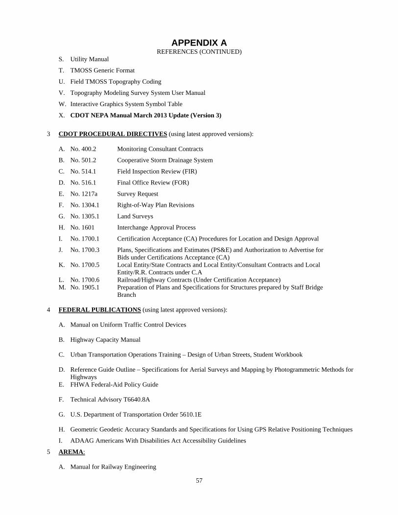
57
APPENDIX A REFERENCES (CONTINUED)
S. Utility Manual
T. TMOSS Generic Format
U. Field TMOSS Topography Coding
V. Topography Modeling Survey System User Manual
W. Interactive Graphics System Symbol Table
X. CDOT NEPA Manual March 2013 Update (Version 3)
3 CDOT PROCEDURAL DIRECTIVES (using latest approved versions):
A. No. 400.2 Monitoring Consultant Contracts
B. No. 501.2 Cooperative Storm Drainage System
C. No. 514.1 Field Inspection Review (FIR)
D. No. 516.1 Final Office Review (FOR)
E. No. 1217a Survey Request
F. No. 1304.1 Right-of-Way Plan Revisions
G. No. 1305.1 Land Surveys
H. No. 1601 Interchange Approval Process
I. No. 1700.1 Certification Acceptance (CA) Procedures for Location and Design Approval
J. No. 1700.3 Plans, Specifications and Estimates (PS&E) and Authorization to Advertise for Bids under Certifications Acceptance (CA)
K. No. 1700.5 Local Entity/State Contracts and Local Entity/Consultant Contracts and Local Entity/R.R. Contracts under C.A
L. No. 1700.6 Railroad/Highway Contracts (Under Certification Acceptance) M. No. 1905.1 Preparation of Plans and Specifications for Structures prepared by Staff Bridge
Branch
4 FEDERAL PUBLICATIONS (using latest approved versions): A. Manual on Uniform Traffic Control Devices
B. Highway Capacity Manual C. Urban Transportation Operations Training – Design of Urban Streets, Student Workbook D. Reference Guide Outline – Specifications for Aerial Surveys and Mapping by Photogrammetric Methods for
Highways E. FHWA Federal-Aid Policy Guide F. Technical Advisory T6640.8A G. U.S. Department of Transportation Order 5610.1E H. Geometric Geodetic Accuracy Standards and Specifications for Using GPS Relative Positioning Techniques
I. ADAAG Americans With Disabilities Act Accessibility Guidelines
5 AREMA: A. Manual for Railway Engineering

58
APPENDIX B SPECIFIC DESIGN CRITERIA
Note: The following criteria will be developed by the consultant and coordinated with the CDOT/PM prior to
starting the design. 1. ROADWAY
A. BASIC DESIGN
The basis for design will be the data in CDOT Form 463, Design Data. A copy of the latest applicable design Data form will be furnished to the consultant
B. GEOMETRIC AND STRUCTURE STANDARDS
a Design Speed
b Horizontal Alignment and Curvature
i Applicable Superelevation Standards
ii Minimum radius of Curvature
iii Use of Spirals
c Vertical Alignment:
i Maximum gradient – CDOT Design Guide
ii Length – CDOT Design Guide
d Sight Distance:
i Stopping -
ii Passing -
iii Decision -
e Superelevation, Applicable Standard
f Frontage Roads, Separation Width
g CDOT Access Code
h Airway – Highway Clearances Design Guide
i Bridges and Grade Separation Structures, Clearances to Structures and Obstructions, CDOT
Design Guide
j Curb and Gutters, Type
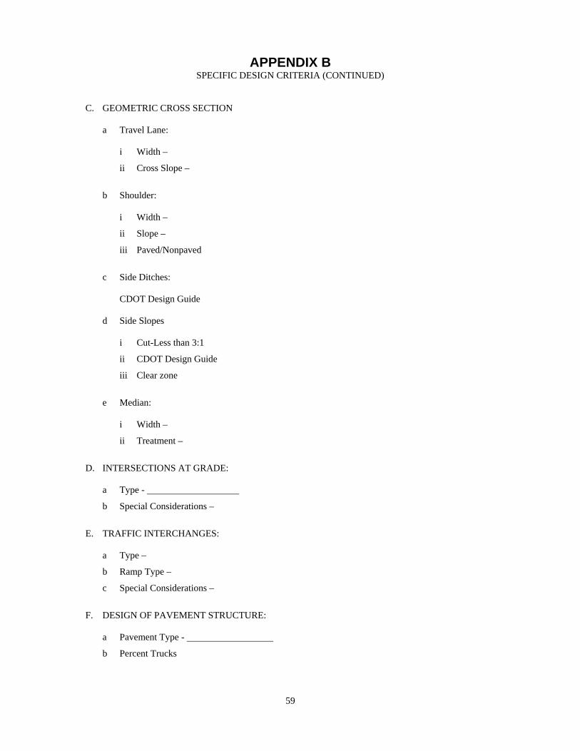
59
APPENDIX B SPECIFIC DESIGN CRITERIA (CONTINUED)
C. GEOMETRIC CROSS SECTION
a Travel Lane:
i Width –
ii Cross Slope –
b Shoulder:
i Width –
ii Slope –
iii Paved/Nonpaved
c Side Ditches:
CDOT Design Guide
d Side Slopes
i Cut-Less than 3:1
ii CDOT Design Guide
iii Clear zone
e Median:
i Width –
ii Treatment –
D. INTERSECTIONS AT GRADE:
a Type -
b Special Considerations –
E. TRAFFIC INTERCHANGES:
a Type –
b Ramp Type –
c Special Considerations –
F. DESIGN OF PAVEMENT STRUCTURE:
a Pavement Type -
b Percent Trucks

60
APPENDIX B SPECIFIC DESIGN CRITERIA (CONTINUED)
c Economic Analysis Period –
d Design Life –
G. MISCELLANEOUS DESIGN CONSIDERATIONS
a Fence Type -
b FEMA Category –
c Design Flood Frequency
H. ROADSIDE DEVELOPMENT
a Landscaping
b Specifications for Revegetating Disturbed Areas to be provided by CDOT.
c Noise Control
d Type
e Guardrail and End Treatments
I. LIGHTING
a Type

61
APPENDIX C DEFINITIONS
1 AASHTO- American Association of State Highway & Transportation Officials
2 ADT- Average two-way 24-hour Traffic in Number of Vehicles
3 AREA- American Railway Engineering Association
4 ATSSA- American Traffic Safety Services Association
5 AT&SF- Atchison, Topeka & Santa Fe Railway Company
6 ADAAG- Americans with Disabilities Accessibility Act Guidelines
7 BAMS- Bid Analysis and Management Systems
8 BLM- Bureau of Land Management
9 BNRR- Burlington Northern Railroad
10 CA- Contract Administrator. The CDOT Manager responsible for
the satisfactory completion of the contract by the consultant.
11 CAP- CDOT’s Action Plan
12 CBC- Concrete Box Culvert
13 CDOT- Colorado Department of Transportation
14 CDOT/PM- Colorado Department of Transportation Project Manager – The CDOT Engineer responsible for the day to day direction and CDOT Consultant coordination of the design effort.
15 CDOT/STR- Colorado Department of Transportation Structure Reviewer –
The CDOT Engineer responsible for reviewing and coordinating major structural design
16 CDPHE- Colorado Department of Public Health and Environment 17 CE Categorical Exclusion
18 CEQ- Council on Environmental Quality
19 COG- Council of Governments
20 COGO- Coordinate Geometry Output
21 CONSULTANT- Consultant for this project
22 CONTRACT ADMINISTRATOR- Typically a Region Engineer or Branch Head. The CDOT
employee directly responsible for the satisfactory completion of the contract by the Consultant. The contract administration is usually delegated to a CDOT Project Manager.

62
APPENDIX C DEFINITIONS (CONTINUED)
23 C/PM- Consultant Project Manager – The Consultant Engineer responsible for combining the various inputs in the process of completing the project plans and managing the Consultant design effort.
24 DEIS- Draft Environmental Impact Statement 25 DHV- Future Design Hourly Volume (two-way unless specified
otherwise) 26 DRCOG- Denver Regional Council of Governments 27 D&RGW- Denver & Rio Grande Western Railroad 28 EA- Environmental Assessment 29 EIS- Environmental Impact Statement 30 ESAL- Equivalent Single Axle Load 31 ESE- Economic, Social and Environmental 32 FEIS- Final Environmental Impact Statement 33 FEMA- Federal Emergency Management Agency 34 FHPG- Federal Aid Highway Policy Guide 35 FHWA- Federal Highway Administration 36 FIPI- Finding In Public Interest 37 FIR- Field Inspection Review 38 FONSI- Finding of No Significant Impact 39 FOR- Final Office Review 40 GPS- Global Positioning System
41 MAJOR STRUCTURES- Bridges and culverts with a total clear span length greater than
twenty feet. This length is measured along the centerline of roadway for bridges and culverts, from abutment face to abutment face, Retaining structures are measured along the horizontal distance along the top of the wall. Structures with exposed heights at any section over five feet and total lengths greater than a hundred feet as well as overhead structures including (bridge signs, cantilevers and butterflies extending over traffic) are also considered major structures.

63
APPENDIX C DEFINITIONS (CONTINUED)
42 MPO- Metropolitan Planning Organization (i.e. Denver Regional
Council of Governments, Pikes Peak Area Council of Governments, Grand Junction MPO, Pueblo MPO, and North Front Range Council of Governments).
43 MS4- Municipal Separate Storm Sewer System
44 NEPA- National Environment Policy Act
45 NGS- National Geodetic Survey
46 NICET- National Institute for Certification in Technology
47 NOAA- National Oceanic and Atmospheric Administration
48 PAPER SIZES- See Computer-Aided Drafting Manual (CDOT);
Table 6-13 and Table 8-1
49 PE- Professional Engineer registered in Colorado
50 PM- Program Manager
51 PLS- Professional Land Surveyor registered in Colorado
52 PRT- Project Review Team
53 PS&E- Plans, Specifications and Estimate
54 PROJECT- The work defined by this scope
55 ROR- Region Office Review
56 ROW- Right-of-Way: A general term denoting land, property, or interest therein, usually in a strip acquired for or devoted to a highway
57 ROWPR- Right-of-Way Plan Review
58 RTD- Regional Transportation Director
59 T/E- Threatened and/or Endangered Species
60 SH- State Highway Numbers 61 TMOSS- Terrain Modeling Survey System 62 TOPOGRAPHY- In the context of CDOT plans, topography normally refers to
existing cultural or man-made details. 63 UD & FCD- Urban Drainage and Flood Control District 64 USCOE- United States Army Corp of Engineers
Note: For other definitions and terms, refer to Section 101 of the CDOT Division of Highways Standard
Specifications for Road and Bridge Construction and the CDOT Design Guide.