science questions, measurement requirements, and
TRANSCRIPT

Science Questions, Measurement Requirements, and Implementation:
Overview from the PACE Science Definition Team Report
Pre-Aerosol, Cloud, ocean Ecosystem mission

Science Questions, Measurement Requirements, and Implementation:
Overview from the PACE Science Definition Team Report
Pelagic and Coastal Ecosystems mission

Pelagic and Coastal Ecosystems mission
Disclaimer: The material presented here does not represent any official view of NASA or PACE mission management regarding the goals or approaches of
the PACE mission. This material summarizes recommendations from the PACE Science Definition Team (SDT). Some, all, or none of these
recommendations may be adopted by NASA for developing the official scope and objectives of the PACE mission and for preparing an Announcement of Opportunity (AO). All of the material presented here is described in detail
(~250 pages) in the publically-available SDT report, which is open for comment during the month of August.

Pelagic and Coastal Ecosystems mission
NASA Ocean Biology & Biogeochemistry
Advanced Plan ACE Ocean Science Team
Lots of ‘lessons learned’ from
heritage sensors/missions

Overarching Science Questions
● How and why are ocean biogeochemical cycles changing? How do they influence the Earth system?
● What are the material exchanges between land and ocean? How do they influence coastal ecosystems and biogeochemistry? How are they changing?
● What are the standing stocks, compositions, and productivity of ocean ecosystems? How and why are they changing?
● How do aerosols influence ocean ecosystems and biogeochemical cycles? How do ocean biological and photochemical processes affect the atmosphere?
● How do physical ocean processes affect ocean ecosystems andbiogeochemistry? How do ocean biological processes influence ocean physics?
● What is the distribution of both harmful and beneficial algal blooms and how is their appearance and demise related to environmental forcings? How are these events changing?
● How do changes in critical ocean ecosystem services affect human health and welfare? How do human activities affect ocean ecosystems and the services they provide? What science-based management strategies need to be implemented to sustain our health and well-being?

SQ-1 Ocean Ecosystems: - Quantify phytoplankton biomass, pigments, and optical properties- Assess key phytoplankton groups (e.g., calcifiers, nitrogen fixers, carbon export)- Estimate particle size distribution and productivity using bio-optical modeling, chlorophyll fluorescence, and ancillary data on ocean physical properties (e.g., SST, MLD, etc.)
- Validate retrievals from pelagic to near-shore environments
SQ-2 Ocean Biogeochemical Cycles: - Quantify phytoplankton biomass, functional groups, POC, PIC, DOC, PSD and productivity- Validate retrievals from pelagic to near-shore environments. - Assimilate observations in biogeochemical models to assess key properties (e.g., air-sea CO2 flux, export)
SQ-3 Land-Ocean Interactions: - Quantify concentrations and physical/optical properties of particles & dissolved material- Validate retrievals from coastal to estuarine environments. - Compare observables with ground-based and model-based land-ocean exchange in the coastal zone,
physical properties (e.g., winds, SST, SSH, etc), and circulation.
Approach
SQ-4 Atmosphere-Ocean Interactions: - Quantify ocean photobiochemical and photobiological processes and atmospheric aerosols - Combine ocean and atmosphere observables with models and other remotely retrieved fields (e.g.
temperature and wind speed) to evaluate (1) air-sea exchange of particulates, dissolved materials, and gasesand (2) impacts on aerosol , cloud, and biological properties
- Validate retrievals from pelagic to near-shore environments

SQ-5 Bio-physical Interactions: - Compare observed ecosystem properties with measured physical ocean properties (e.g., winds, SST, SSH,
OOI assets) and model-derived physical fields (e.g., ML dynamics, horizontal divergence)- Estimate ocean radiant heating and assess feedbacks- Validate from pelagic to near-shore environments
SQ-6 Algal Blooms and Consequences: - Measure biomass, pigments, and abundance of key phytoplankton groups, including harmful algae- Quantify bloom magnitudes, durations, and distributions- Assess inter-seasonal and inter-annual variations- Compare variability to changing environmental/physical properties - Validate retrievals from pelagic to near-shore environments
SQ-7: Human Dimensions:- Establish close linkages between science, operational, and resource management communities early
in the planning phases of PACE and maintain feedbacks throughout mission life. - Engage management and operational communities fully in science planning efforts - Estimate the social and economic impacts of ocean ecology, including biodiversity, biogeochemical
processes, and biological and chemical stocks and fluxes- Understand the applications of PACE products for water quality assessments and pollution
identification. - Implement strong education and capacity building programs addressing national & international needs.
Approach (cont.)

• Normalized water-leaving radiances • Chlorophyll-a • Diffuse attenuation coefficient (490 nm)
• Inherent optical properties • Spectral Kd• Euphotic depth• Spectral remote sensing reflectance • Particulate organic carbon concentration • Primary production • Calcite concentration • Colored dissolved organic matter • Photosynthetically available radiation • Fluorescence line height • Total suspended matter • Trichodesmium concentration • Particle size distributions & composition • Phytoplankton carbon • Dissolved organic matter/carbon • Physiological properties • Phytoplankton pigment absorption spectra • Export production• Functional/Taxonomic groups
PRODUCT ASSESSMENTS• Parameter Description• Measurement Methodology• Error analysis• Accuracy Assessment
GEOPHYSICAL PARAMETERS• Parameter description & units• Baseline & Threshold Ranges• Evaluation details
Targeted Ocean Retrievals
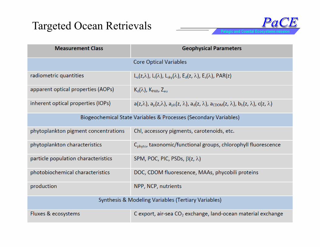
Targeted Ocean Retrievals
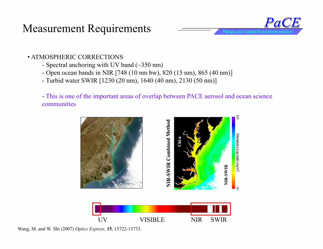
• ATMOSPHERIC CORRECTIONS- Spectral anchoring with UV band (~350 nm)- Open ocean bands in NIR [748 (10 nm bw), 820 (15 nm), 865 (40 nm)]- Turbid water SWIR [1230 (20 nm), 1640 (40 nm), 2130 (50 nm)]
- This is one of the important areas of overlap between PACE aerosol and ocean science communities
Measurement Requirements
UV VISIBLE NIR SWIRWang, M. and W. Shi (2007) Optics Express, 15, 15722-15733.

• ATMOSPHERIC CORRECTIONS• CDOM / SEPARATION FROM PIGMENT ABSORPTION
- Current uncertainty impacts NPP assessment by 16 Gt y-1 (total ~50 Gt y-1)- Near UV bands [360 (15 nm),380 (15 nm)]
UV VISIBLE NIR SWIR
Measurement Requirements
cDO
M absorption (relative)
9060300
-30-60
Norm
alized percentage O
C4-G
SM difference
Colored dissolved m
aterial (m-1)
0.1
0.01
0.001
Siegel et al.,

• ATMOSPHERIC CORRECTIONS• CDOM / SEPARATION FROM PIGMENT ABSORPTION
- Current uncertainty impacts NPP assessment by 16 Gt y-1 (total ~50 Gt y-1)- Near UV bands [360 (15 nm),380 (15 nm)]
UV VISIBLE NIR SWIR
Measurement Requirements
Siegel et al.,
Mon
thly
Ano
moa
ylo
g(pr
oper
ty)

• ATMOSPHERIC CORRECTIONS• CDOM-PIGMENT SEPARATION• PHYTOPLANKTON ABSORPTION SPECTRA
- Productivity keyed to total pigment absorption, not simply chlorophyll concentration- Assess both the amplitude and breadth of absorption spectra- 15 nm resolution in blue-green region
UV VISIBLE NIR SWIR
Measurement Requirements

• ATMOSPHERIC CORRECTIONS• CDOM-PIGMENT SEPARATION• PHYTOPLANKTON ABSORPTION SPECTRA• PHYTOPLANKTON CARBON; TOTAL PARTICULATE CARBON
- Chlorophyll is not biomass- Carbon stocks related to particulate scattering coefficients and spectral slope- 15 nm bands in the region of minimum pigment absorption
UV VISIBLE NIR SWIR
Measurement Requirements
SeaWiFS chlorophyll variability due to biomass SeaWiFS chlorophyll variability due to physiology
Siegel et al., in review

• ATMOSPHERIC CORRECTIONS• CDOM-PIGMENT SEPARATION• PHYTOPLANKTON ABSORPTION SPECTRA• PHYTOPLANKTON CARBON; TOTAL PARTICULATE CARBON
- Chlorophyll is not biomass- Carbon stocks related to particulate scattering coefficients and spectral slope- 15 nm bands in the region of minimum pigment absorption
UV VISIBLE NIR SWIR
Measurement Requirements
Slope of the Particle Size Distribution
Kostadinov et al., 2009

• ATMOSPHERIC CORRECTIONS• CDOM-PIGMENT SEPARATION• PHYTOPLANKTON ABSORPTION SPECTRA• PHYTOPLANKTON CARBON; TOTAL PARTICULATE CARBON
- Chlorophyll is not biomass- Carbon stocks related to particulate scattering coefficients and spectral slope- 15 nm bands in the region of minimum pigment absorption
Measurement Requirements
Picoparticles %
(0.5 mm
to 2 mm
)
Microparticles %
(20 mm
to 30 mm
)
Nanoparticles %
(2 m
m to 20 m
m)
Tihomir Kostadinov et al

• ATMOSPHERIC CORRECTIONS• CDOM-PIGMENT SEPARATION• PHYTOPLANKTON ABSORPTION SPECTRA• PHYTOPLANKTON/TOTAL PARTICULATE CARBON• PHYTOPLANKTON PHYSIOLOGY
- How do we interpret observed chlorophyll trends? - How do we account for unique nutrient effects? - What are the ecological responses to atmospheric nutrient deposition?- Ratio of pigment absorption to phytoplankton carbon - general light and nutrient effects- Chlorophyll fluorescence quantum yield [665 (10 nm), 678 (10 nm), 710 (15 nm)] –detection of iron-stressed populations
UV VISIBLE NIR SWIR
Measurement Requirements
1
0.1
0.01
0.001
Fe d
epos
ition
( ng
m-2
s-1 )
φ sat
(%)
0.7%
1.4%
2.1%
2.8%
0%
Behrenfeld et al. Biogeosciences 6, 779-794, 2009.

• ATMOSPHERIC CORRECTIONS• CDOM-PIGMENT SEPARATION• PHYTOPLANKTON ABSORPTION SPECTRA• PHYTOPLANKTON/TOTAL PARTICULATE CARBON• PHYTOPLANKTON PHYSIOLOGY
- How do we interpret observed chlorophyll trends? - How do we account for unique nutrient effects? - What are the ecological responses to atmospheric nutrient deposition?- Ratio of pigment absorption to phytoplankton carbon - general light and nutrient effects- Chlorophyll fluorescence quantum yield [665 (10 nm), 678 (10 nm), 710 (15 nm)] –detection of iron-stressed populations
UV VISIBLE NIR SWIR
Measurement Requirements
Westberry et al. 2012
Chl:CKerguelen
Chl:CSOIREE
Chl:CSERIES
Fluor YieldSERIES

• ATMOSPHERIC CORRECTIONS• CDOM-PIGMENT SEPARATION• PHYTOPLANKTON ABSORPTION SPECTRA• PHYTOPLANKTON/TOTAL PARTICULATE CARBON• PHYTOPLANKTON PHYSIOLOGY• EUTROPHIC WATERS / HARMFUL ALGAL SPECIES
- How are bloom events changing? Duration, extent, timing, composition?-‘Red-edge’ algorithms for pigment stocks (red-NIR band differences)- Near-UV and/or 710 nm band for HABs
UV VISIBLE NIR SWIR
Measurement Requirements
Image & data from Chuanmin Hu, Univ. South Florida

• ATMOSPHERIC CORRECTIONS• CDOM-PIGMENT SEPARATION• PHYTOPLANKTON ABSORPTION SPECTRA• PHYTOPLANKTON/TOTAL PARTICULATE CARBON• PHYTOPLANKTON PHYSIOLOGY• EUTROPHIC WATERS / HARMFUL ALGAL SPECIES• PHYTOPLANKTON FUNCTIONAL GROUPS
- Phytoplankton community composition is ecologically and biogeochemically important- How is it changing? What detail can we derive from space?- ‘Multi-band’ approaches for targeted organism- ‘Hyperspectral’ (5 nm) derivative analysis for multiple broad groups
UV VISIBLE NIR SWIR
Measurement Requirements
cyan
obac
teri
a
diat
oms

Calcification (mg C m-3 d-1)0 2 4 6 8 10 12 14 16
SST ChlPIC
• ATMOSPHERIC CORRECTIONS• CDOM-PIGMENT SEPARATION• PHYTOPLANKTON ABSORPTION SPECTRA• PHYTOPLANKTON/TOTAL PARTICULATE CARBON• PHYTOPLANKTON PHYSIOLOGY• EUTROPHIC WATERS / HARMFUL ALGAL SPECIES• PHYTOPLANKTON FUNCTIONAL GROUPS• PARTICULATE INORGANIC CARBON
- Calcifying organisms play a key role in carbon export and surface carbon chemistry- Complication of POC from backscattering coefficients- Green, Red, NIR bands for open ocean and coastal waters
UV VISIBLE NIR SWIR
Measurement Requirements

Polarization
Mineraldominated
Phytoplanktondominated
• ATMOSPHERIC CORRECTIONS• CDOM-PIGMENT SEPARATION• PHYTOPLANKTON ABSORPTION SPECTRA• PHYTOPLANKTON/TOTAL PARTICULATE CARBON• PHYTOPLANKTON PHYSIOLOGY• EUTROPHIC WATERS / HARMFUL ALGAL SPECIES• PHYTOPLANKTON FUNCTIONAL GROUPS• PARTICULATE INORGANIC CARBON• LAND-OCEAN MATERIAL EXCHANGE
- Distinguishing mineral and biotic particles through polarization properties
Rio de la Plata
Measurement Requirements

• ATMOSPHERIC CORRECTIONS• CDOM-PIGMENT SEPARATION• PHYTOPLANKTON ABSORPTION SPECTRA• PHYTOPLANKTON/TOTAL PARTICULATE CARBON• PHYTOPLANKTON PHYSIOLOGY• EUTROPHIC WATERS / HARMFUL ALGAL SPECIES• PHYTOPLANKTON FUNCTIONAL GROUPS• PARTICULATE INORGANIC CARBON• LAND-OCEAN MATERIAL EXCHANGE• HERITAGE OCEAN COLOR BANDS
- Flexible reconstruction: 412, 443, 490, 510, 532, 555, 665, 678, 710, 765, 865 nm
Measurement Requirements

‘agg
rega
te b
and’
list
Hig
h sp
ectra
l res
olut
ion
rang
e (5
nm
)
Threshold RequirementsPACE multispectral band specifications.SNR-spec is the minimum value at Ltyp.
Radiances are in mW/cm2 str.
Ltyp = typical top-of-atmosphere clear sky ocean radiances

Orbit
Global Coverage
Navigation and Registration
Instrument Performance Tracking
Instrument Artifacts
• sun-synchronous polar orbit• equatorial crossing time between 11:00 and 1:00• orbit maintenance to ±10 minutes over mission lifetime• 2-day global coverage to solar zenith angle of 75o
• mitigation of sun glint• multiple daily observations at high latitudes• view zenith angles not exceeding ±60o
• mission lifetime of 5 years•pointing accuracy of 2 IFOV and knowledge equivalent to 0.1 IFOV over the full range of viewing geometries (e.g., scan and tilt angles)• pointing jitter of 0.01 IFOV between adjacent scans or image rows• spatial band-to-band registration of 80% of one IFOV between any two bands, without resampling• simultaneity of 0.02 second• characterization of all detectors and optical components through monthly lunar observations through Earth-viewing port• characterization of instrument performance changes to ±0.2% within the first 3 years and maintenance of this accuracy thereafter for the duration of the mission• monthly characterization of instrument spectral drift to an accuracy of 0.3 nm• daily measurement of dark current and observations of a calibration target/source, with knowledge of daily calibration source degradation to ~0.2%• Prelaunch characterization of linearity, RVVA, polarization sensitivity, radiometric and spectral temperature sensitivity, high contrast resolution, saturation, saturation recovery, crosstalk, radiometric and band-to-band stability, bidirectional reflectance distribution, and relative spectral response • overall instrument artifact contribution to TOA radiance of <0.5%• characterization & correction for image striping to noise levels or below• crosstalk contribution to radiance uncertainties 0.1% at Ltyp• polarization sensitivity of ≤1% and knowledge of polarization sensitivity to ≤ 0.2%• no detector saturation for any science measurement bands at Lmax• RVVA of <5% for the entire view angle range and by <0.5% for view angles that differ by less than 1o
• Stray light contamination < 0.2% of Ltyp 3 pixels away from a cloud• out-of-band contamination of <0.01 for all multispectral channels• radiance-to-counts relationship characterized to 0.1% over full dynamic range (Ltyp to Lmax)
Threshold Requirements

Spatial ResolutionAtmospheric Corrections
Science Spectral Bands
Signal-to-noise
Data Reprocessing
• Global spatial coverage of 1 km x 1 km (±0.1 km) along-track• retrieval of [rw(l)]N for open-ocean, clear-water conditions and standard marine atmospheres with an accuracy of the maximum of either 5% or 0.001 over the wavelength range 400 – 710 nm• two NIR atmospheric correction bands comparable to heritage, one of which is centered at 865 nm• NUV band centered near 350• SWIR bands centered at 1240, 1640, and 2130 nm• 5 nm spectral resolution from 355 to 800 nm• complete ground station downlink and archival of 5 nm data. • SNR at Ltyp of 1000 from 360 to 710 nm; 300 @ 350 nm; 600 @ NIR bands; 250, 180, and 15 @ 1240, 1640, & 2130 nm• full reprocessing capability of all PACE data at a minimum frequency of 1 – 2 times annually.
Threshold Requirements
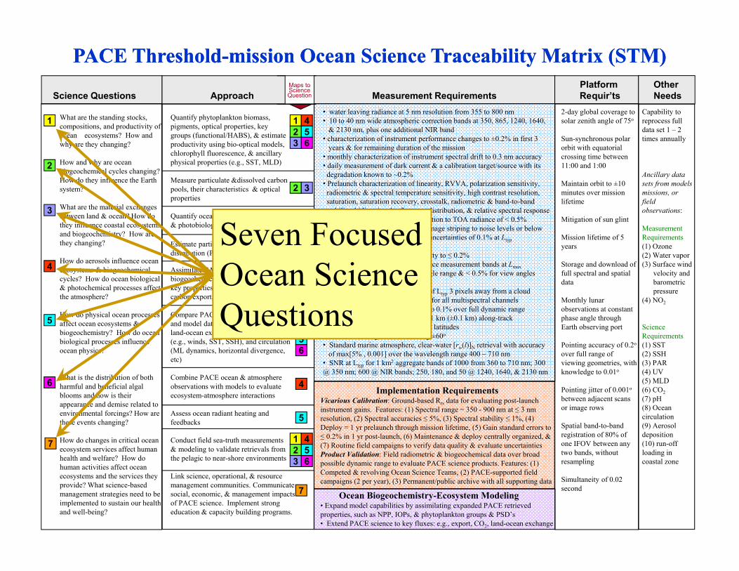
PACE Threshold-mission Ocean Science Traceability Matrix (STM)PACE Threshold-mission Ocean Science Traceability Matrix (STM)
Implementation RequirementsVicarious Calibration: Ground-based Rrs data for evaluating post-launch instrument gains. Features: (1) Spectral range = 350 - 900 nm at ≤ 3 nm resolution, (2) Spectral accuracies ≤ 5%, (3) Spectral stability ≤ 1%, (4) Deploy = 1 yr prelaunch through mission lifetime, (5) Gain standard errors to ≤ 0.2% in 1 yr post-launch, (6) Maintenance & deploy centrally organized, & (7) Routine field campaigns to verify data quality & evaluate uncertaintiesProduct Validation: Field radiometric & biogeochemical data over broad possible dynamic range to evaluate PACE science products. Features: (1) Competed & revolving Ocean Science Teams, (2) PACE-supported field campaigns (2 per year), (3) Permanent/public archive with all supporting data
Ocean Biogeochemistry-Ecosystem Modeling• Expand model capabilities by assimilating expanded PACE retrieved properties, such as NPP, IOPs, & phytoplankton groups & PSD’s• Extend PACE science to key fluxes: e.g., export, CO2, land-ocean exchange
1
2
3
4
5
6
What are the standing stocks, compositions, and productivity of ocean ecosystems? How and why are they changing?
How and why are ocean biogeochemical cycles changing? How do they influence the Earth system?
What are the material exchanges between land & ocean? How do they influence coastal ecosystems and biogeochemistry? How are they changing?
How do aerosols influence ocean ecosystems & biogeochemical cycles? How do ocean biological & photochemical processes affect the atmosphere?
How do physical ocean processes affect ocean ecosystems & biogeochemistry? How do ocean biological processes influence ocean physics?
What is the distribution of both harmful and beneficial algal blooms and how is their appearance and demise related to environmental forcings? How are these events changing?
How do changes in critical ocean ecosystem services affect human health and welfare? How do human activities affect ocean ecosystems and the services they provide? What science-based management strategies need to be implemented to sustain our health and well-being?
7
Quantify phytoplankton biomass, pigments, optical properties, key groups (functional/HABS), & estimate productivity using bio-optical models, chlorophyll fluorescence, & ancillary physical properties (e.g., SST, MLD)
Measure particulate &dissolved carbon pools, their characteristics & optical properties
Quantify ocean photobiochemical & photobiological processes
Estimate particle abundance, size distribution (PSD), & characteristics
Assimilate PACE observations in ocean biogeochemical model fields to evaluate key properties (e.g., air-sea CO2 flux, carbon export, pH, etc.)
Compare PACE observations with field-and model data of biological properties, land-ocean exchange, physical properties (e.g., winds, SST, SSH), and circulation (ML dynamics, horizontal divergence, etc)
Combine PACE ocean & atmosphere observations with models to evaluate ecosystem-atmosphere interactions
Assess ocean radiant heating and feedbacks
Conduct field sea-truth measurements & modeling to validate retrievals from the pelagic to near-shore environments
Link science, operational, & resource management communities. Communicate social, economic, & management impacts of PACE science. Implement strong education & capacity building programs.
12
2
2
2
3
3
3
4
4
4
4
5
5
53
4
6
123
456
6
7
1
2-day global coverage to solar zenith angle of 75o
Sun-synchronous polar orbit with equatorial crossing time between 11:00 and 1:00
Maintain orbit to ±10 minutes over mission lifetime
Mitigation of sun glint
Mission lifetime of 5 years
Storage and download of full spectral and spatial data
Monthly lunar observations at constant phase angle through Earth observing port
Pointing accuracy of 0.2o
over full range of viewing geometries, with knowledge to 0.01o
Pointing jitter of 0.001o
between adjacent scans or image rows
Spatial band-to-band registration of 80% of one IFOV between any two bands, without resampling
Simultaneity of 0.02 second
Capability to reprocess full data set 1 – 2 times annually
Ancillary data sets from models missions, or field observations:
MeasurementRequirements(1) Ozone(2) Water vapor(3) Surface wind
velocity andbarometricpressure
(4) NO2
ScienceRequirements(1) SST(2) SSH(3) PAR(4) UV(5) MLD(6) CO2(7) pH(8) Ocean circulation(9) Aerosol deposition(10) run-off loading in coastal zone
• water leaving radiance at 5 nm resolution from 355 to 800 nm• 10 to 40 nm wide atmospheric correction bands at 350, 865, 1240, 1640,
& 2130 nm, plus one additional NIR band• characterization of instrument performance changes to ±0.2% in first 3
years & for remaining duration of the mission• monthly characterization of instrument spectral drift to 0.3 nm accuracy • daily measurement of dark current & a calibration target/source with its
degradation known to ~0.2%• Prelaunch characterization of linearity, RVVA, polarization sensitivity,
radiometric & spectral temperature sensitivity, high contrast resolution,saturation, saturation recovery, crosstalk, radiometric & band-to-bandstability, bidirectional reflectance distribution, & relative spectral response
• overall instrument artifact contribution to TOA radiance of < 0.5%• characterization & correction for image striping to noise levels or below• crosstalk contribution to radiance uncertainties of 0.1% at Ltyp• polarization sensitivity ≤ 1%• knowledge of polarization sensitivity to ≤ 0.2%• no detector saturation for any science measurement bands at Lmax• RVVA of < 5% for entire view angle range & < 0.5% for view angles
differing by less than 1o
• Stray light contamination < 0.2% of Ltyp 3 pixels away from a cloud• Out-of-band contamination < 0.01 for all multispectral channels• Radiance-to-counts characterized to 0.1% over full dynamic range • Global spatial coverage of 1 km x 1 km (±0.1 km) along-track• Multiple daily observations at high latitudes• View zenith angles not exceeding ±60o
• Standard marine atmosphere, clear-water [rw(l)]N retrieval with accuracyof max[5% , 0.001] over the wavelength range 400 – 710 nm
• SNR at Ltyp for 1 km2 aggregate bands of 1000 from 360 to 710 nm; 300 @ 350 nm; 600 @ NIR bands; 250, 180, and 50 @ 1240, 1640, & 2130 nm
Maps toScienceQuestion
Platform OtherScience Questions Approach Measurement Requirements Requir’ts Needs
Seven Focused Ocean Science Questions

PACE Threshold-mission Ocean Science Traceability Matrix (STM)PACE Threshold-mission Ocean Science Traceability Matrix (STM)
Implementation RequirementsVicarious Calibration: Ground-based Rrs data for evaluating post-launch instrument gains. Features: (1) Spectral range = 350 - 900 nm at ≤ 3 nm resolution, (2) Spectral accuracies ≤ 5%, (3) Spectral stability ≤ 1%, (4) Deploy = 1 yr prelaunch through mission lifetime, (5) Gain standard errors to ≤ 0.2% in 1 yr post-launch, (6) Maintenance & deploy centrally organized, & (7) Routine field campaigns to verify data quality & evaluate uncertaintiesProduct Validation: Field radiometric & biogeochemical data over broad possible dynamic range to evaluate PACE science products. Features: (1) Competed & revolving Ocean Science Teams, (2) PACE-supported field campaigns (2 per year), (3) Permanent/public archive with all supporting data
Ocean Biogeochemistry-Ecosystem Modeling• Expand model capabilities by assimilating expanded PACE retrieved properties, such as NPP, IOPs, & phytoplankton groups & PSD’s• Extend PACE science to key fluxes: e.g., export, CO2, land-ocean exchange
1
2
3
4
5
6
What are the standing stocks, compositions, and productivity of ocean ecosystems? How and why are they changing?
How and why are ocean biogeochemical cycles changing? How do they influence the Earth system?
What are the material exchanges between land & ocean? How do they influence coastal ecosystems and biogeochemistry? How are they changing?
How do aerosols influence ocean ecosystems & biogeochemical cycles? How do ocean biological & photochemical processes affect the atmosphere?
How do physical ocean processes affect ocean ecosystems & biogeochemistry? How do ocean biological processes influence ocean physics?
What is the distribution of both harmful and beneficial algal blooms and how is their appearance and demise related to environmental forcings? How are these events changing?
How do changes in critical ocean ecosystem services affect human health and welfare? How do human activities affect ocean ecosystems and the services they provide? What science-based management strategies need to be implemented to sustain our health and well-being?
7
Quantify phytoplankton biomass, pigments, optical properties, key groups (functional/HABS), & estimate productivity using bio-optical models, chlorophyll fluorescence, & ancillary physical properties (e.g., SST, MLD)
Measure particulate &dissolved carbon pools, their characteristics & optical properties
Quantify ocean photobiochemical & photobiological processes
Estimate particle abundance, size distribution (PSD), & characteristics
Assimilate PACE observations in ocean biogeochemical model fields to evaluate key properties (e.g., air-sea CO2 flux, carbon export, pH, etc.)
Compare PACE observations with field-and model data of biological properties, land-ocean exchange, physical properties (e.g., winds, SST, SSH), and circulation (ML dynamics, horizontal divergence, etc)
Combine PACE ocean & atmosphere observations with models to evaluate ecosystem-atmosphere interactions
Assess ocean radiant heating and feedbacks
Conduct field sea-truth measurements & modeling to validate retrievals from the pelagic to near-shore environments
Link science, operational, & resource management communities. Communicate social, economic, & management impacts of PACE science. Implement strong education & capacity building programs.
12
2
2
2
3
3
3
4
4
4
4
5
5
53
4
6
123
456
6
7
1
2-day global coverage to solar zenith angle of 75o
Sun-synchronous polar orbit with equatorial crossing time between 11:00 and 1:00
Maintain orbit to ±10 minutes over mission lifetime
Mitigation of sun glint
Mission lifetime of 5 years
Storage and download of full spectral and spatial data
Monthly lunar observations at constant phase angle through Earth observing port
Pointing accuracy of 0.2o
over full range of viewing geometries, with knowledge to 0.01o
Pointing jitter of 0.001o
between adjacent scans or image rows
Spatial band-to-band registration of 80% of one IFOV between any two bands, without resampling
Simultaneity of 0.02 second
Capability to reprocess full data set 1 – 2 times annually
Ancillary data sets from models missions, or field observations:
MeasurementRequirements(1) Ozone(2) Water vapor(3) Surface wind
velocity andbarometricpressure
(4) NO2
ScienceRequirements(1) SST(2) SSH(3) PAR(4) UV(5) MLD(6) CO2(7) pH(8) Ocean circulation(9) Aerosol deposition(10) run-off loading in coastal zone
• water leaving radiance at 5 nm resolution from 355 to 800 nm• 10 to 40 nm wide atmospheric correction bands at 350, 865, 1240, 1640,
& 2130 nm, plus one additional NIR band• characterization of instrument performance changes to ±0.2% in first 3
years & for remaining duration of the mission• monthly characterization of instrument spectral drift to 0.3 nm accuracy • daily measurement of dark current & a calibration target/source with its
degradation known to ~0.2%• Prelaunch characterization of linearity, RVVA, polarization sensitivity,
radiometric & spectral temperature sensitivity, high contrast resolution,saturation, saturation recovery, crosstalk, radiometric & band-to-bandstability, bidirectional reflectance distribution, & relative spectral response
• overall instrument artifact contribution to TOA radiance of < 0.5%• characterization & correction for image striping to noise levels or below• crosstalk contribution to radiance uncertainties of 0.1% at Ltyp• polarization sensitivity ≤ 1%• knowledge of polarization sensitivity to ≤ 0.2%• no detector saturation for any science measurement bands at Lmax• RVVA of < 5% for entire view angle range & < 0.5% for view angles
differing by less than 1o
• Stray light contamination < 0.2% of Ltyp 3 pixels away from a cloud• Out-of-band contamination < 0.01 for all multispectral channels• Radiance-to-counts characterized to 0.1% over full dynamic range • Global spatial coverage of 1 km x 1 km (±0.1 km) along-track• Multiple daily observations at high latitudes• View zenith angles not exceeding ±60o
• Standard marine atmosphere, clear-water [rw(l)]N retrieval with accuracyof max[5% , 0.001] over the wavelength range 400 – 710 nm
• SNR at Ltyp for 1 km2 aggregate bands of 1000 from 360 to 710 nm; 300 @ 350 nm; 600 @ NIR bands; 250, 180, and 50 @ 1240, 1640, & 2130 nm
Maps toScienceQuestion
Platform OtherScience Questions Approach Measurement Requirements Requir’ts Needs
Ocean Spectrometer• UV/Vis high spectral resolution• Fluorescence capability• NIR & SWIR bands• Sensor tilt• Climate quality data focus
Supporting Datasets for Science
Additional requirements beyond the sensor itself …

PACE Threshold-mission Ocean Science Traceability Matrix (STM)PACE Threshold-mission Ocean Science Traceability Matrix (STM)
Implementation RequirementsVicarious Calibration: Ground-based Rrs data for evaluating post-launch instrument gains. Features: (1) Spectral range = 350 - 900 nm at ≤ 3 nm resolution, (2) Spectral accuracies ≤ 5%, (3) Spectral stability ≤ 1%, (4) Deploy = 1 yr prelaunch through mission lifetime, (5) Gain standard errors to ≤ 0.2% in 1 yr post-launch, (6) Maintenance & deploy centrally organized, & (7) Routine field campaigns to verify data quality & evaluate uncertaintiesProduct Validation: Field radiometric & biogeochemical data over broad possible dynamic range to evaluate PACE science products. Features: (1) Competed & revolving Ocean Science Teams, (2) PACE-supported field campaigns (2 per year), (3) Permanent/public archive with all supporting data
Ocean Biogeochemistry-Ecosystem Modeling• Expand model capabilities by assimilating expanded PACE retrieved properties, such as NPP, IOPs, & phytoplankton groups & PSD’s• Extend PACE science to key fluxes: e.g., export, CO2, land-ocean exchange
1
2
3
4
5
6
What are the standing stocks, compositions, and productivity of ocean ecosystems? How and why are they changing?
How and why are ocean biogeochemical cycles changing? How do they influence the Earth system?
What are the material exchanges between land & ocean? How do they influence coastal ecosystems and biogeochemistry? How are they changing?
How do aerosols influence ocean ecosystems & biogeochemical cycles? How do ocean biological & photochemical processes affect the atmosphere?
How do physical ocean processes affect ocean ecosystems & biogeochemistry? How do ocean biological processes influence ocean physics?
What is the distribution of both harmful and beneficial algal blooms and how is their appearance and demise related to environmental forcings? How are these events changing?
How do changes in critical ocean ecosystem services affect human health and welfare? How do human activities affect ocean ecosystems and the services they provide? What science-based management strategies need to be implemented to sustain our health and well-being?
7
Quantify phytoplankton biomass, pigments, optical properties, key groups (functional/HABS), & estimate productivity using bio-optical models, chlorophyll fluorescence, & ancillary physical properties (e.g., SST, MLD)
Measure particulate &dissolved carbon pools, their characteristics & optical properties
Quantify ocean photobiochemical & photobiological processes
Estimate particle abundance, size distribution (PSD), & characteristics
Assimilate PACE observations in ocean biogeochemical model fields to evaluate key properties (e.g., air-sea CO2 flux, carbon export, pH, etc.)
Compare PACE observations with field-and model data of biological properties, land-ocean exchange, physical properties (e.g., winds, SST, SSH), and circulation (ML dynamics, horizontal divergence, etc)
Combine PACE ocean & atmosphere observations with models to evaluate ecosystem-atmosphere interactions
Assess ocean radiant heating and feedbacks
Conduct field sea-truth measurements & modeling to validate retrievals from the pelagic to near-shore environments
Link science, operational, & resource management communities. Communicate social, economic, & management impacts of PACE science. Implement strong education & capacity building programs.
12
2
2
2
3
3
3
4
4
4
4
5
5
53
4
6
123
456
6
7
1
2-day global coverage to solar zenith angle of 75o
Sun-synchronous polar orbit with equatorial crossing time between 11:00 and 1:00
Maintain orbit to ±10 minutes over mission lifetime
Mitigation of sun glint
Mission lifetime of 5 years
Storage and download of full spectral and spatial data
Monthly lunar observations at constant phase angle through Earth observing port
Pointing accuracy of 0.2o
over full range of viewing geometries, with knowledge to 0.01o
Pointing jitter of 0.001o
between adjacent scans or image rows
Spatial band-to-band registration of 80% of one IFOV between any two bands, without resampling
Simultaneity of 0.02 second
Capability to reprocess full data set 1 – 2 times annually
Ancillary data sets from models missions, or field observations:
MeasurementRequirements(1) Ozone(2) Water vapor(3) Surface wind
velocity andbarometricpressure
(4) NO2
ScienceRequirements(1) SST(2) SSH(3) PAR(4) UV(5) MLD(6) CO2(7) pH(8) Ocean circulation(9) Aerosol deposition(10) run-off loading in coastal zone
• water leaving radiance at 5 nm resolution from 355 to 800 nm• 10 to 40 nm wide atmospheric correction bands at 350, 865, 1240, 1640,
& 2130 nm, plus one additional NIR band• characterization of instrument performance changes to ±0.2% in first 3
years & for remaining duration of the mission• monthly characterization of instrument spectral drift to 0.3 nm accuracy • daily measurement of dark current & a calibration target/source with its
degradation known to ~0.2%• Prelaunch characterization of linearity, RVVA, polarization sensitivity,
radiometric & spectral temperature sensitivity, high contrast resolution,saturation, saturation recovery, crosstalk, radiometric & band-to-bandstability, bidirectional reflectance distribution, & relative spectral response
• overall instrument artifact contribution to TOA radiance of < 0.5%• characterization & correction for image striping to noise levels or below• crosstalk contribution to radiance uncertainties of 0.1% at Ltyp• polarization sensitivity ≤ 1%• knowledge of polarization sensitivity to ≤ 0.2%• no detector saturation for any science measurement bands at Lmax• RVVA of < 5% for entire view angle range & < 0.5% for view angles
differing by less than 1o
• Stray light contamination < 0.2% of Ltyp 3 pixels away from a cloud• Out-of-band contamination < 0.01 for all multispectral channels• Radiance-to-counts characterized to 0.1% over full dynamic range • Global spatial coverage of 1 km x 1 km (±0.1 km) along-track• Multiple daily observations at high latitudes• View zenith angles not exceeding ±60o
• Standard marine atmosphere, clear-water [rw(l)]N retrieval with accuracyof max[5% , 0.001] over the wavelength range 400 – 710 nm
• SNR at Ltyp for 1 km2 aggregate bands of 1000 from 360 to 710 nm; 300 @ 350 nm; 600 @ NIR bands; 250, 180, and 50 @ 1240, 1640, & 2130 nm
Maps toScienceQuestion
Platform OtherScience Questions Approach Measurement Requirements Requir’ts Needs
Models are essential for achieving PACE science objectives
Field validation and calibration, new measurements, process studies, and algorithm development are central to mission and thus required in flight project budget

Measurement Goals
Accuracy: Retrieval of normalized [rw(l)]N for open-ocean, clear-water conditions and standard marine atmospheres with an accuracy of the maximum of either 10% or 0.002 over the wavelength range of 350 – 395 nmAerosol heights: Identified approach or measurement capacity for evaluating/measuring aerosol vertical distributions and type for improved atmospheric corrections. Atmospheric correction: SWIR atmospheric correction band at 2130 nm with a SNR of 100. Coverage: 1-day global coverage; Coverage to a solar zenith angle >75o
Crossing time: Noon equatorial crossing time (±10 min)Instrument artifact: Overall instrument artifact contribution to TOA radiance retrievals of <0.2%.Navigation and Registration: pointing knowledge of 0.05 IFOV; band-to-band registration of 90% of one IFOV; simultaneity of 0.01 secondNitrogen dioxide: Identified approach for characterizing NO2 and ozone concentrations at sufficient accuracy for improving atmospheric correctionsMission lifetime: 10 yearsPerformance changes: Characterization of instrument performance changes to ±0.1% within 3 years and maintenance of this accuracy thereafterSaturation: No detector saturation for any science measurement bands up to 1.2 × LmaxSignal-to-noise: SNR for bio-optical science bands and/or atmospheric correction bands greater than those specified for mission threshold requirementsSpatial resolution: Spatial resolution of 1 km2 (±10%) at all scan angles; Along-track spatial resolution of 250 m x 250 m to 500 m x 500 m for inland, estuarine, coastal, and shelf area retrievals for all bands or a subset of bands.Spectral coverage: 5 nm spectral coverage from 800 to 900 nmSpectral subsampling: ~1-2 nm resolution from 655 to 710 nm for refined characterization of the chlorophyll fluorescence spectrumWater vapor: Spectral measurement band centered at 820 nm or 940 nm to determine water vapor content

…Final Comments…
Pre-Aerosol, Cloud, ocean Ecosystem mission