saudi sandstone correlations - schlumberger/media/files/resources/mearr/wer16/... · saudi...
TRANSCRIPT


Saudi Sandstone Correlations
Large volumes of oil have recently beendiscovered in the Palaeozoic Unayzah
sandstones of central Saudi Arabia. While themain reservoirs in the Permian Unayzah arewell-understood by Saudi Aramco, the pre-
Silurian section has proved to be morecomplex. However, detailed geological studiesand thorough integration of all data, includingwireline logs, electrical borehole imagery and
core led geologists to some startlingconclusions and significant discoveries about
the nature of the sedimentary sequence incentral Saudi Arabia. These new correlations
will have a major influence on future oil and gasexploration in the region.
Tom Connally, of Saudi Aramco, and ElliottWiltse outline the efforts which were required to
decipher the depositional history of the oil-bearing sandstones and discuss the wider
implications of this discovery.

Abu Jifan
Dilam
Raghib
Hilwah
Ulayyah
Nuayyim
Ghinah
HazmiyahHawtah
Riyadh
Ghawar
Qirdi
Qatar
Khurais
Bahrain
HRDH
ST
Ain Dar
0 50 100
Km
Seismic line
28 Middle East Well Evaluation Review
The recent discovery of large vol-
umes of super light oil in the
Unayzah sandstones in central
Saudi Arabia (figure 2.1) has pleased
explorationists from the Saudi Arabian
Oil Company (see Middle East Well
Evaluation Review, Number 11, 1991).
Since these discoveries were made,
Saudi Aramco's geologists and engineers
have been trying to decipher the deposi-
tional history of the deeper pre-Silurian
sandstones. Initially, they were thought
to be equivalent to the Saq Formation
and the Hanadir member of the Qasim
Group (figure 2.2), which lies beneath
the major oil-bearing zones to the east.
There were good reasons to assume this.
The new sandstone units were remark-
ably similar to the more familiar rocks
found in the east, they occurred at simi-
lar depths, had approximately the same
thickness (about 3000 ft) and lay below a
major Silurian shale source rock.
By the late 1980s, wireline logs
recorded in the new fields of Dilam,
Hawtah, Hilwah, Nuayyim and Raghib
were being compared with logs in the
more easterly Ghawar Field. The logs
were significantly different in the deeper
part of the wells, below the main oil-bear-
ing intervals. Characteristic marker
shales from the deep Saq and Qasim for-
mations, which were obvious in the
Ghawar logs, could not be found in logs
from the new wells. The absence of dis-
tinctive ‘marker beds’ made it difficult to
divide the new sandstone sequence into
separate stratigraphic units. Lacking
clear lithostratigraphic information, and
without fossil evidence to help identify
and date the rock layers, geologists faced
a tricky correlation.
Surface seismic surveys taken across
the central region did not make the pic-
ture any clearer. The resolution of the
deep seismic data was poor in the
deeper parts of the basin, partly due to
the overlying Khuff carbonate layer
which absorbed much of the seismic
energy. A conventional wireline log cor-
relation between wells was attempted
but this did not help to identify the units.
Though the wells had been extensively
cored it was impossible to produce a reli-
able correlation of the sandstones
between wells. Age dating of fossils
which were found in minor shales within
the sandstones indicated that the
sequence may have been younger than
the familiar Saq Formation with which a
correlation was being sought, but in the
light of the overwhelming lithostrati-
graphic similarity of the units, this sce-
nario was considered very unlikely.
Fig. 2.1: Location map
of the area of interest in
central Saudi Arabia.
29Number 16, 1996.
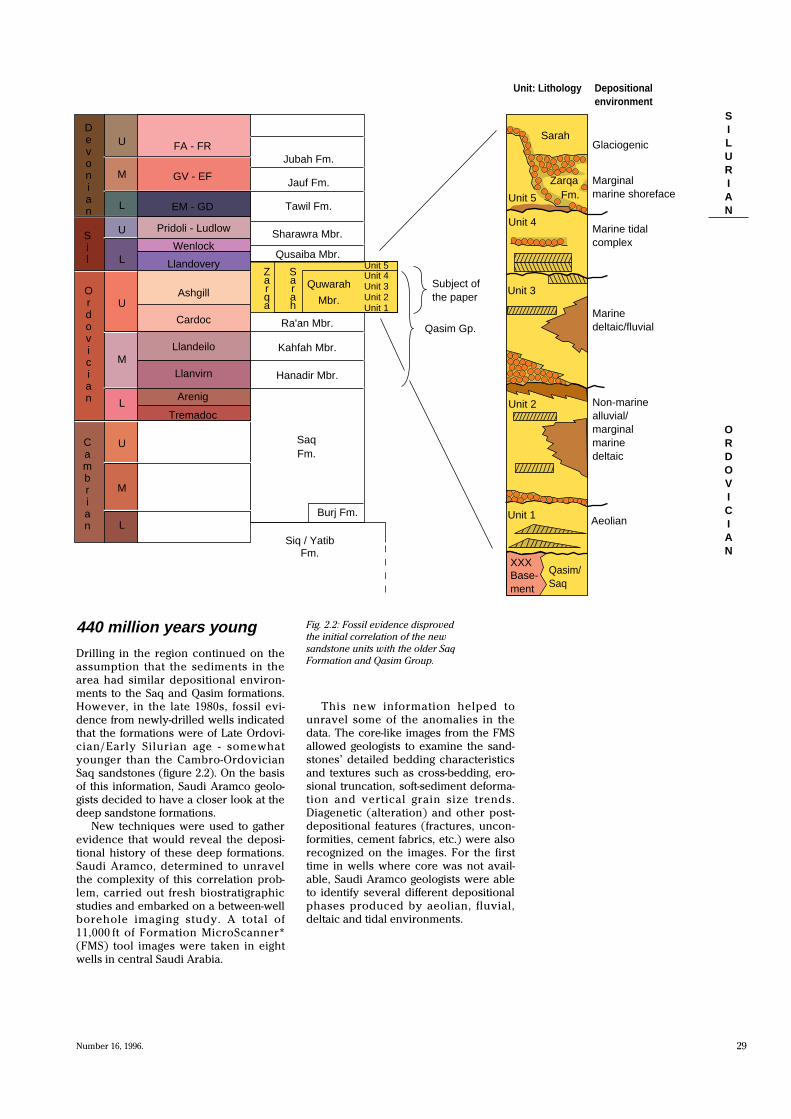
440 million years young
Drilling in the region continued on the
assumption that the sediments in the
area had similar depositional environ-
ments to the Saq and Qasim formations.
However, in the late 1980s, fossil evi-
dence from newly-drilled wells indicated
that the formations were of Late Ordovi-
cian/Early Silurian age - somewhat
younger than the Cambro-Ordovician
Saq sandstones (figure 2.2). On the basis
of this information, Saudi Aramco geolo-
gists decided to have a closer look at the
deep sandstone formations.
New techniques were used to gather
evidence that would reveal the deposi-
tional history of these deep formations.
Saudi Aramco, determined to unravel
the complexity of this correlation prob-
lem, carried out fresh biostratigraphic
studies and embarked on a between-well
borehole imaging study. A total of
11,000 ft of Formation MicroScanner*
(FMS) tool images were taken in eight
wells in central Saudi Arabia.
This new information helped to
unravel some of the anomalies in the
data. The core-like images from the FMS
allowed geologists to examine the sand-
stones’ detailed bedding characteristics
and textures such as cross-bedding, ero-
sional truncation, soft-sediment deforma-
tion and vertical grain size trends.
Diagenetic (alteration) and other post-
depositional features (fractures, uncon-
formities, cement fabrics, etc.) were also
recognized on the images. For the first
time in wells where core was not avail-
able, Saudi Aramco geologists were able
to identify several different depositional
phases produced by aeolian, fluvial,
deltaic and tidal environments.
Fig. 2.2: Fossil evidence disproved
the initial correlation of the new
sandstone units with the older Saq
Formation and Qasim Group.
D e v o n i a n
S i l
O r d o v i c i a n
C a m b r i a n
Jubah Fm.
Jauf Fm.
Tawil Fm.
Subject of the paper
Qasim Gp.
U
M
L
U
M
L
U
U
M
L
L
Sharawra Mbr.
Qusaiba Mbr.
Ra'an Mbr.
Kahfah Mbr.
Hanadir Mbr.
Burj Fm.
Siq / Yatib Fm.
Z a r q a
S a r a h
Quwarah
Mbr.
Unit 4 Unit 3 Unit 2 Unit 1
Unit: Lithology
Sarah
Marginal marine shoreface
Marine tidal complex
Marine deltaic/fluvial
Non-marine alluvial/ marginal marine deltaic
Depositional environment
Zarqa
Aeolian
Base- ment
Qasim/ Saq
XXX
Unit 1
Unit 2
Unit 3
Unit 4
Unit 5 Fm.
S I L U R I A N
O R D O V I C I A N
GlaciogenicFA - FR
GV - EF
EM - GD
Ashgill
Cardoc
Llandeilo
Llanvirn
Arenig
Tremadoc
Pridoli - Ludlow
Wenlock
Llandovery
Saq Fm.
Unit 5

30 Middle East Well Evaluation Review
Fig. 2.3a: A continental
alluvial fan - the probable
depositional environment for
the sediments which comprise
Unit 2.
Basin basics
Detailed analysis of sedimentology and
palaeocurrent directions in the five
Upper Ordovician formations (Units 1 to
5) has helped in the understanding of
basin development during the Middle
and Upper Ordovician. It has also
explained a great deal about the difficul-
ties geologists have experienced in the
past.
Unit 1 is a well-sorted fine-grained
quartzarenite which reaches thicknesses
of 400 ft (122 m) and has a conglomerate
layer at its base. On logs, the formation
appears as a ‘clean’ blocky low gamma-
ray interval with high porosities. The
sandstone contains steeply dipping
cross-beds with a consistent trend. It is
not bioturbated and there is no evidence
of marine influence. Unit 1 was deposited
on land and is the result of wind action in
a semi-desert or desert environment.
Unit 2 was deposited in an alluvial fan
environment (figure 2.3a) with sediments
sourced from the west and north. The
unit, which can be up to 600 ft (183 m)
thick, is composed of various sediments
ranging from siltstone to coarse conglom-
erates and pebbly sandstones (figure
2.3b).
Several features identify this unit.
• There are low-angle tabular and trough
cross-beds.
• The unit displays a moderately high
gamma-ray response with a serrated
appearance.
• There are variable dips which trend
east to south.
• Bioturbation (sediment disturbance
caused by burrowing organisms) is rare.
• There is moderate diagenetic alter-
ation with patchy cementation.
• Average grain size increases toward
the western margin of the depositional
basin. In general, grain size increases as
we approach the sediment source.
1ft
Fanhead trenches
Proximal fan
Mid-fan
Distal fan
Streamflow
Fault line
Mountains
Fig. 2.3b: Excellent
pebble conglomerate in
Ordovician Unit 2. This
example is taken from
a typical Ulayyah well.

31Number 16, 1996.
Fig. 2.4a: Tidal bundles from a typical Hawtah
well showing the increasing marine influence
through Unit 3.
Fig. 2.5b: The low-
angle cross-beds in this
FMS image from a
typical Hawtah well
are characteristic of the
fluvial-deltaic facies.
Fig. 2.4b: Alluvial fan
and fan delta, depositional
environments - lower part of Unit 3.
Fig. 2.5a: Fluvial-deltaic
depositional environment
- upper part of Unit 3.
The Unit 3 sandstone contains a mix-
ture of quartz and lithic fragments. The
average grain size of this interval
increases from the base to the top. In
one section, the unit is more than 1300 ft
(397 m) thick. Cores and FMS imagery
indicate that both the upper and lower
Unit 3 contacts are erosional unconformi-
ties. Identifying and understanding the
nature of gaps within and between each
unit is essential for accurate correlation
across the region.
The main distinguishing characteris-
tics of Unit 3 are as follows.
• There are low-angle tabular and trough
cross-beds (less than 10°).
• A moderately high gamma ray
response with a serrated appearance.
• Dips trend east to south.
• Bioturbation, mostly vertical Skolithostype trace fossils, is common.
• Diagenetic alteration is moderate with
patchy and vein-fill cementation preva-
lent especially in the coarse-grained sec-
tions in the western wells.
• The average grain size trend becomes
coarser toward the western margin of the
depositional basin.
The lower part of Unit 3 is an alluvial
fan and fan delta (figure 2.4a and b), but
the upper part shows a greater marine
influence, with low-angle cross-beds
characteristic of fluvial-deltaic environ-
ments (figure 2.5a and b).
1ft
1ft
Sea
N
High-angle fault
Debris flow fansConglomeratic alluvium Proximal
alluviumDistal
alluvium
Flood plain Sea
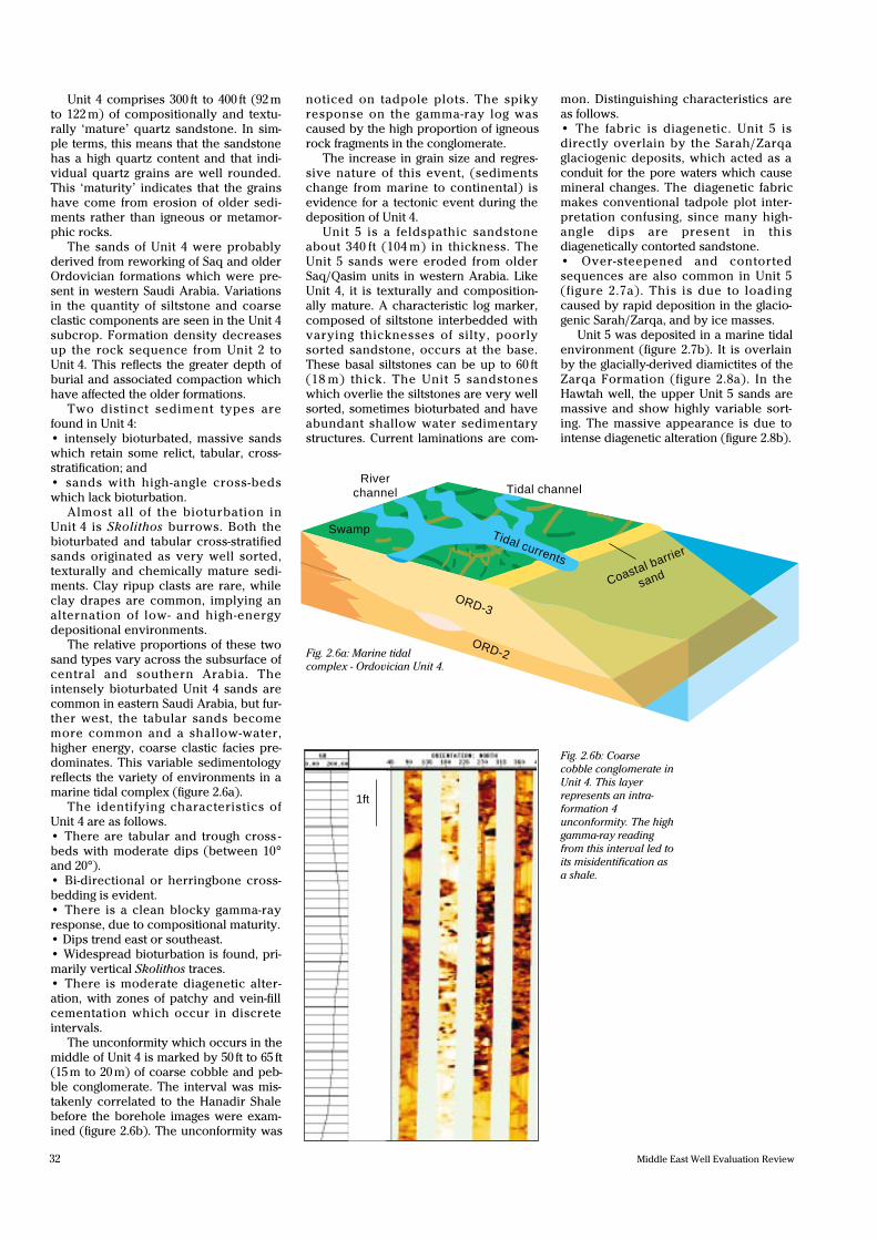
Fig. 2.6a: Marine tidal
complex - Ordovician Unit 4.
�� �RR T££ ¥Tidal channel
River channel
Tidal currents
ORD-3
ORD-2
Coastal barrier
sand
Swamp
32 Middle East Well Evaluation Review
Fig. 2.6b: Coarse
cobble conglomerate in
Unit 4. This layer
represents an intra-
formation 4
unconformity. The high
gamma-ray reading
from this interval led to
its misidentification as
a shale.
Unit 4 comprises 300 ft to 400 ft (92 m
to 122 m) of compositionally and textu-
rally ‘mature’ quartz sandstone. In sim-
ple terms, this means that the sandstone
has a high quartz content and that indi-
vidual quartz grains are well rounded.
This ‘maturity’ indicates that the grains
have come from erosion of older sedi-
ments rather than igneous or metamor-
phic rocks.
The sands of Unit 4 were probably
derived from reworking of Saq and older
Ordovician formations which were pre-
sent in western Saudi Arabia. Variations
in the quantity of siltstone and coarse
clastic components are seen in the Unit 4
subcrop. Formation density decreases
up the rock sequence from Unit 2 to
Unit 4. This reflects the greater depth of
burial and associated compaction which
have affected the older formations.
Two distinct sediment types are
found in Unit 4:
• intensely bioturbated, massive sands
which retain some relict, tabular, cross-
stratification; and
• sands with high-angle cross-beds
which lack bioturbation.
Almost all of the bioturbation in
Unit 4 is Skolithos burrows. Both the
bioturbated and tabular cross-stratified
sands originated as very well sorted,
texturally and chemically mature sedi-
ments. Clay ripup clasts are rare, while
clay drapes are common, implying an
alternation of low- and high-energy
depositional environments.
The relative proportions of these two
sand types vary across the subsurface of
central and southern Arabia. The
intensely bioturbated Unit 4 sands are
common in eastern Saudi Arabia, but fur-
ther west, the tabular sands become
more common and a shallow-water,
higher energy, coarse clastic facies pre-
dominates. This variable sedimentology
reflects the variety of environments in a
marine tidal complex (figure 2.6a).
The identifying characteristics of
Unit 4 are as follows.
• There are tabular and trough cross -
beds with moderate dips (between 10°
and 20°).
• Bi-directional or herringbone cross-
bedding is evident.
• There is a clean blocky gamma-ray
response, due to compositional maturity.
• Dips trend east or southeast.
• Widespread bioturbation is found, pri-
marily vertical Skolithos traces.
• There is moderate diagenetic alter-
ation, with zones of patchy and vein-fill
cementation which occur in discrete
intervals.
The unconformity which occurs in the
middle of Unit 4 is marked by 50 ft to 65 ft
(15 m to 20 m) of coarse cobble and peb-
ble conglomerate. The interval was mis-
takenly correlated to the Hanadir Shale
before the borehole images were exam-
ined (figure 2.6b). The unconformity was
noticed on tadpole plots. The spiky
response on the gamma-ray log was
caused by the high proportion of igneous
rock fragments in the conglomerate.
The increase in grain size and regres-
sive nature of this event, (sediments
change from marine to continental) is
evidence for a tectonic event during the
deposition of Unit 4.
Unit 5 is a feldspathic sandstone
about 340 ft (104 m) in thickness. The
Unit 5 sands were eroded from older
Saq/Qasim units in western Arabia. Like
Unit 4, it is texturally and composition-
ally mature. A characteristic log marker,
composed of siltstone interbedded with
varying thicknesses of silty, poorly
sorted sandstone, occurs at the base.
These basal siltstones can be up to 60 ft
(18 m) thick. The Unit 5 sandstones
which overlie the siltstones are very well
sorted, sometimes bioturbated and have
abundant shallow water sedimentary
structures. Current laminations are com-
mon. Distinguishing characteristics are
as follows.
• The fabric is diagenetic. Unit 5 is
directly overlain by the Sarah/Zarqa
glaciogenic deposits, which acted as a
conduit for the pore waters which cause
mineral changes. The diagenetic fabric
makes conventional tadpole plot inter-
pretation confusing, since many high-
angle dips are present in this
diagenetically contorted sandstone.
• Over-steepened and contorted
sequences are also common in Unit 5
(figure 2.7a). This is due to loading
caused by rapid deposition in the glacio-
genic Sarah/Zarqa, and by ice masses.
Unit 5 was deposited in a marine tidal
environment (figure 2.7b). It is overlain
by the glacially-derived diamictites of the
Zarqa Formation (figure 2.8a). In the
Hawtah well, the upper Unit 5 sands are
massive and show highly variable sort-
ing. The massive appearance is due to
intense diagenetic alteration (figure 2.8b).
1ft
Fig. 2.8a: Facies tract
across Unit 5 shelf, with Zarqa
proglacial streams advancing from the
southwest.
Fig. 2.7b:
A marine tidal
depositional
environment - Unit 5.
���������������
��������������������
��������
Precambrian
Precambrian
N
O R D - 4
HRDH
ABJF
DILM
ORD-2
ORD-1
ORD-3
Saq
Qasim
HRDH PROJ
RGHB
ABJF PROJ
NYYM PROJ
HWTHHLWH
ULYH
V-well
Intertidal
Tidal channels
Subtidal upper shelf
Zarqa braided plain
33Number 16, 1996.
Fig. 2.7a: This FMS image from a typical Hawtah well shows soft sediment
deformation in Unit 5. This type of deformation is common in Unit 5 and
may be the result of ice loading during the end-Ordovician glaciation.
Fig. 2.8b: This FMS image from a Hawtah well
shows the base of the Zarqa diamictites lying
unconformably on diagenetically altered Unit 5
sediments.
Coastal p
lain
Bay Ebbtidal Delta
Waves
Barrier
Unit 5
������������������������������������������������������������������������������������������������������������������������������������������������������������������������������������������������������������������������������������������������������������
yyyyyyyyyyyyyyyyyyyyyyyyyyyyyyyyyyyyyyyyyyyyyyyyyyyyyyyyyyyyyyyyyyyyyyyyyyyyyyyyyyyyyyyyyyyyyyyyyyyyyyyyyyyyyyyyyyyyyyyyyyyyyyyyyyyyyyyyyyyyyyyyyyyyyyyyyyyyyyyyyyyyyyyyyyyyyyyyyyyyyyyyyyyyyyyyyyyyyyyyyyyyyyyyyyyyyyyyyyyyyyyyyyyyyyyyyyyyyyyyyyyyyyyyyyyy
1ft
1ft

34 Middle East Well Evaluation Review
Sarah/Zarqa formations
At the end of the Ordovician, most of the
continents were located in the southern
hemisphere, in or around the landmass
which geologists refer to as Gondwana.
The African landmass occupied the
South Polar position and was affected by
direct glacial processes. The effects of
glaciation - ice sheets, glacial till deposits
and intense glacial erosion - are
recorded in Africa, South America and
the Middle East (figures 2.9 and 2.10).
In central Arabia the Zarqa Formation
provides clear evidence of glaciation.
The Zarqa is a heterolithic unit which
infilled glacial palaeovalleys. Around
Hawtah and Nuayyim, it is composed of
interbedded diamictites, trough to tabu-
lar cross-bedded sandstones and rare
siltstones. The diamictites, which lie
unconformably above Unit 5 (figure
2.11), consist mainly of quartzite with
lesser amounts of chert. Granite,
metavolcanic, metasedimentary and sed-
imentary rock fragments are also present
in significant amounts.
South Pole
Ice flow directions
Glacial deposits
Fig. 2.10: At the end of the Ordovician, most of the continents were clustered around the South Pole
and experiencing the effects of a short-lived but intense glaciation. Ice sheets covered much of Africa
and reached South America and the Middle East. The diamictites of the Zarqa Formation are typical
of the glacial sediments deposited at this time.
Fig. 2.9: Various
sedimentary mechanisms
associated with the end-
Ordovician glaciation.
Glacier snout
Englacial debris
Basal debris
Lodgement tillMarine sediment
Subaquatic flow till

35Number 16, 1996.
The supporting matrix is poorly
sorted, fine-grained siltstone and sand-
stone. Using borehole imagery, we can
identify several distinguishing character-
istics for the Zarqa Formation.
• There are random, high-angle dips in
the glaciogenic sediments (the scatter of
values on a dip plot is often referred to
as a ‘bag of nails’).
• Rounded to elongated clasts are pre-
sent, which range in size from granules
to cobbles.
• The bedding seen in cores and FMS
images of the diamictites has often been
over-steepened by ice loading and rapid
sedimentation (figure 2.12).
• Massive bedding, cut-and-fill scour fea-
tures, micro-faulting and soft sediment
slumping are also common.
• Sandstone bedforms range from paral-
lel to tabular cross-bedded.
The Sarah Formation is known, from
subsurface records, to extend from
southeastern Saudi Arabia to southern
Jordan. Despite this large geographical
extent, the unit is usually less than 300 ft
(92 m) thick.
In west-central Arabia, the Sarah
Formation consists of pebbly, poorly
sorted, parallel to tabular cross-bedded
sandstones (figure 2.13). The pebbles in
these sandstones are composed primar-
ily of quartzite and chert. Metavolcanic
and igneous clasts are present, but rare.
Rare marine microfossils and bioturba-
tion structures have been recorded. On
borehole images and on logs, the distin-
guishing characteristics for the Sarah
Formation are as follows.
• There is a blocky, moderately high
gamma-ray response. The Sarah Forma-
tion is invariably cleaner than the Zarqa
Formation.
• Log porosity is higher than in the
Zarqa Formation.
• A finer average grain size, more sand-
stone and more uni-directional lower
angle bedforms are found in the Sarah
Formation than in the Zarqa Formation.
Fig. 2.11: FMS from a Raghib well, showing the
unconformable base of the Zarqa.Fig. 2.12: FMS from a Hawtah well
showing Zarqa Formation diamictites
with steeply dipping cross-beds.
Fig. 2.13: FMS from
a typical Nuayyim
well showing the
base of Sarah
Formation sands
above the
unconformity, and
diamictites below it.
1ft 1ft
1ft

36 Middle East Well Evaluation Review
Marking boundaries
Having gathered and examined a wealth
of sedimentological data, Saudi Aramco’s
geoscientists turned their attention to the
cross-well correlation which had previ-
ously eluded them. Sequence bound-
aries at each formation contact were
identified by examining:
• distinct changes in induration (identi-
fied as colour changes on the FMS);
• intra-formational conglomerates;
• ‘hardground’ fabrics at the sequence
boundary indicating periods of non-
deposition and cementation;
• bedding thickness changes; and
• changing dip azimuth and magnitude in
cross-bedded sandstones at boundaries.
Mineral analysis of data gathered by
the GLT* (Geochemical Logging Tool)
indicated that the composition of the
sandstones in the central region was sig-
nificantly different from those in the Saq
Formation (figure 2.14).
Examination of dip and bedding data
showed that the dominant palaeocurrent
direction for the Upper Ordovician sand-
stones was towards the southeast -
almost opposite to that in outcrops of the
Saq Formation where palaeocurrents
trend north or northeast (figures 2.15 and
2.16).
This conclusive evidence prompted
Saudi Aramco to re-examine the correla-
tions between sand sequences found in
well intervals below the giant Ghawar
Field. Many of the sequences which had
previously been diagnosed as Cambro-
Ordovician proved to be younger
Middle to Late Ordovician in age.
Armed with clear proof that the sand-
stones were younger than the neigh-
bouring Saq Formation, Saudi Aramco
explorationists embarked on a more
detailed study of the images. An exami-
nation of the FMS data using the Image
Examiner Workstation immediately
proved that the same vertical sequence
occurred within each of the eight wells.
The re-interpreted conglomerate layer
proved an excellent marker, particularly
in the Raghib Field.
One of the study’s most startling reve-
lations was that the Saq and overlying
Qasim formations had been eroded in
the central region and replaced by
younger rocks.
Fig. 2.14: Comparison of the ‘older’ section in
the Ain Dar well and the ‘younger’ Ordovician
section in the Hawtah well. Mineralogical data
from the GLT* tool in the Hawtah well is
compared with X-Ray diffraction (XRD)
analysis of cuttings from the Ain Dar well.
X5000
X5200
Mid
dle
Shale
Arkose
Sub-arkose/arkose
Quartzarenite
Quartzarenite/sublithic arenite
Arkose/sub-arkose
Quartzarenite
Qusaiba
Sarah/Zarqa
Unit 5
Unit 4
Unit 3
Unit 2
Unit 1
X4200
X4400
X4600
X4800
X5400
X5600
X5800
X6000
Quwarah
Ra’an
Kahfah
Handir
A
B
C
Lower
Mid
dle
Upp
erLo
wer
Upp
er
LowerSarah
QASIM
SAQ
Cam
bria
nO
rdov
icia
n
Silurian
Shaly sand/sub-graywacke
Shale
Siltstone/graywacke
Shale
Graywacke
Quartzarenite
Arkose
ANDRHAWTAH
Igneous
Low
erU
pper
Mid
dle
Precambrian
Ord
ovic
ian
Silu
rian
X3600
X3800
X4000
X6200
X6400

37Number 16, 1996.
Fig. 2.15: Stratigraphic cross-section using Unit 4
as the datum, based on raw data. Transport
directions are predominantly to the southeast
and east. This is clearly different to the transport
directions recorded in the Saq Formation which
are to the north and northeast, in the area north
of Riyadh.
Fig. 2.16: Bedding and cross-
bedding picked in the Saq section
from a well in the far north,
showing transport directions to
the north and northeast.
X550
T/03
Sarah/Zarqa glacial valley
Base pebbly lower Zurqa
T/04T/04T/04 Datum: T/04
Intra-04 unconformity
Basal 04 unconformityT/03
Intra-04 conglomerate
X650
X750
X850
X950
X750
X850
X950
X050
X150
X550
X650
X750
X850
X950
X050
X350
X450
X550
X650
X750
X550
X650
X750
X850
X950
HAWTAH HILWAH RAGHIB DILAM ABJFNS
N
W E
S1 ft
38 Middle East Well Evaluation Review
KRSN
ABJF
DILMULYH
V
VNYMHWTH
HLWH RGHB
HRDH
ANDRSDGM
UTMN UTMNUTMNUTMN
MKSR
200
0
0
400
600
800 10
00
1000
800200
Upper Ordovician thickness
Basement0 50 100
km
Isopach contoursin feet
300 200
0
600800
200
400
600
800
0
0 50 100
km
Upper Ordovician thickness
Isopach contours in feet
KRSN
DILMULYH
V
V
NYMHWTH
HLWHRGHB
HRDH
ANDR
SDGMUTMN UTMN
UTMNUTMN
MKSR
ABJF
Basement
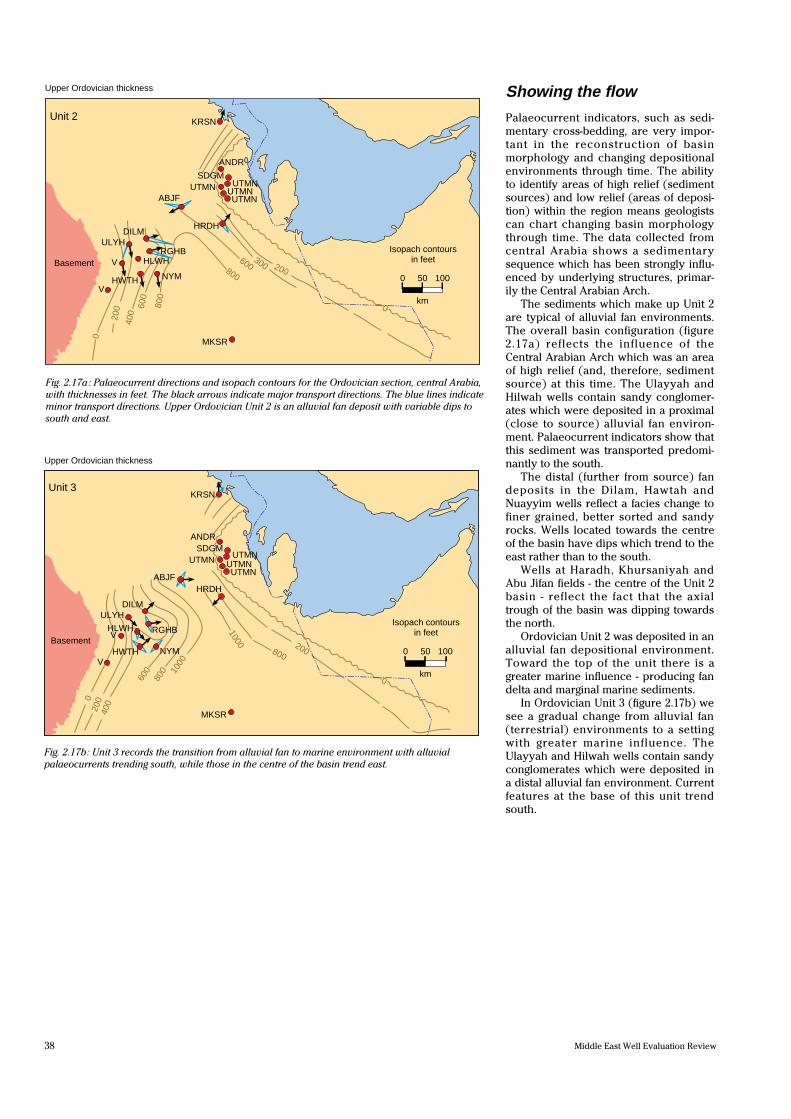
Fig. 2.17a: Palaeocurrent directions and isopach contours for the Ordovician section, central Arabia,
with thicknesses in feet. The black arrows indicate major transport directions. The blue lines indicate
minor transport directions. Upper Ordovician Unit 2 is an alluvial fan deposit with variable dips to
south and east.
Fig. 2.17b: Unit 3 records the transition from alluvial fan to marine environment with alluvial
palaeocurrents trending south, while those in the centre of the basin trend east.
Unit 2
Unit 3
Showing the flow
Palaeocurrent indicators, such as sedi-
mentary cross-bedding, are very impor-
tant in the reconstruction of basin
morphology and changing depositional
environments through time. The ability
to identify areas of high relief (sediment
sources) and low relief (areas of deposi-
tion) within the region means geologists
can chart changing basin morphology
through time. The data collected from
central Arabia shows a sedimentary
sequence which has been strongly influ-
enced by underlying structures, primar-
ily the Central Arabian Arch.
The sediments which make up Unit 2
are typical of alluvial fan environments.
The overall basin configuration (figure
2.17a) reflects the influence of the
Central Arabian Arch which was an area
of high relief (and, therefore, sediment
source) at this time. The Ulayyah and
Hilwah wells contain sandy conglomer-
ates which were deposited in a proximal
(close to source) alluvial fan environ-
ment. Palaeocurrent indicators show that
this sediment was transported predomi-
nantly to the south.
The distal (further from source) fan
deposits in the Dilam, Hawtah and
Nuayyim wells reflect a facies change to
finer grained, better sorted and sandy
rocks. Wells located towards the centre
of the basin have dips which trend to the
east rather than to the south.
Wells at Haradh, Khursaniyah and
Abu Jifan fields - the centre of the Unit 2
basin - reflect the fact that the axial
trough of the basin was dipping towards
the north.
Ordovician Unit 2 was deposited in an
alluvial fan depositional environment.
Toward the top of the unit there is a
greater marine influence - producing fan
delta and marginal marine sediments.
In Ordovician Unit 3 (figure 2.17b) we
see a gradual change from alluvial fan
(terrestrial) environments to a setting
with greater marine influence. The
Ulayyah and Hilwah wells contain sandy
conglomerates which were deposited in
a distal alluvial fan environment. Current
features at the base of this unit trend
south.

39Number 16, 1996.
Fig. 2.17c : The abundance of long shore drift sedimentary dips in Unit 4 (c) indicates a marine
environment.
The appearance of deltaic/shoreface
sediments reflects a change to finer
grained, better sorted, more sandy facies
in wells at Dilam, Hawtah, Nuayyim and
Abu Jifan. Overall, the direction of trans-
port in the basin is towards the east.
Marine environment tidal and wave-
generated currents dominate the upper
part of this unit. Tidal bundles and bi-
directional dips (which indicate wave
motion) become more abundant. Dip
magnitude and dip azimuth variation are
common in the fully marine Upper
Ordovician Unit 3. Sediment samples
from Haradh mark a shallow eastern
shelf of the basin.
The basin morphology for Unit 4 (fig-
ure 2.17c) also reflects the influence of
the Central Arabian Arch. The directional
features in the northwest wells - at Dilam
and Raghib - trend more to the south
than in the basinward wells of Hawtah,
Nuayyim, and Hilwah. Wells located in
the centre of the Unit 4 basin, at Abu
Jifan, Haradh and Khursaniyah, reflect
the fact that the axial trough of the basin
was dipping to the north. Eastern wells of
the Unit 4 basin do not indicate the pres-
ence of an eastern shelf. Long shore drift
sedimentary dips are more common (in
wells at Dilam and Raghib) underlining
the marine nature of this tidal deposit.
The Central Arabian Arch also played
a significant role in the regional basin
configuration during the deposition of
Unit 5 (figure 2.17d). Palaeocurrent fea-
tures in the northwestern wells (at Dilam
and Raghib) are directed predominantly
to the south, in contrast to the more bas-
inward wells located at Hawtah,
Nuayyim and Hilwah.
The end of the Ordovician was
marked by a global glaciation, centred
on North Africa. We might expect that
the facies and basin configuration
encountered in the Upper Ordovician
would be very different from those in the
Cambrian or Lower Ordovician. In the
absence of high-quality deep seismic
data, (quality being limited by the thick
Khuff Formation) we must understand
basin morphology and facies distribution
in order to predict the geographical and
stratigraphic position of reservoirs.
KRSN
ABJF
DILMULYH
V
VNYMHWTH
HLWH RGHB
HRDH
ANDRSDGM
UTMN UTMNUTMNUTMN
MKSR20
030
040
0
400
300
200
0
Upper Ordovician thickness
Basement0 50 100
km
Isopach contoursin feet
KRSN
ABJF
DILMULYH
V
VNYMHWTH
HLWH RGHB
HRDH
ANDRSDGM
UTMN UTMNUTMNUTMN
MKSR
300
200
HRDHHRDH
200
0
300
0
Upper Ordovician thickness
Basement0 50 100
km
Isopach contoursin feet
Fig. 2.17d: Unit 5 is marked by the influence of the Central Arabian Arch, dividing the shallow
marine environment into two distinct sub-basins.
Unit 4
Unit 5
40 Middle East Well Evaluation Review
Tectonic ups and downs
During the Early Ordovician, compres-
sional forces caused a period of uplift in
central Arabia. The Central Arabian
bulge formed a topographic high which
was probably subjected to faulting dur-
ing the Middle Ordovician.
The valleys filled with Middle and
Upper Ordovician sediments - including
Units 1 to 5 which, although younger
than the rocks in the horsts, occur at
similar depths. This process, coupled
with the lithostratigraphic similarity of
the older and younger units and a lack of
fossil material for age identification,
made the initial interpretation difficult.
At present, Saudi Aramco explo-
rationists are investigating the tectonic
movements which led to the initial uplift,
associated erosion and subsequent
down-faulting of these central sand-
stones. These movements were followed
by a major depositional period lasting
approximately 30 M years which led to
the creation of the Upper Ordovician
Units 1 to 5 and Sarah/Zarqa sandstone
units.
removed Unit 5 by erosion. The diamic-
tites are poorly-sorted, clastic rocks
which contain a wide range of particle
sizes.
This new understanding of basin
development has improved the interpre-
tation of other formations in Arabia. In
addition, the re-processing of seismic
data, guided by FMS images, is helping
explorationists to find tectonic deforma-
tions in southern and central Arabia.
Saudi Aramco geologists are currently
reinterpreting old data to help redefine
the seismic sequence boundaries and
determine unconformities.
Each sandstone was deposited in a
different environment. The oldest unit
is an (as yet undated) aeolian sand-
stone, produced in a desert-like envi-
ronment. This is a clean and well sorted
sand with well rounded grains and a
consistent cross-bedding direction - all
characteristic features of aeolian
deposits. Above this are the thicker
sediments which make up Unit 2 and
Unit 3. These were deposited in deltaic
or distal alluvial environments which
produced fine-grained rocks with low -
angle cross-bedded sands and conglom-
erates.
Unit 4, which overlies Unit 3, com-
prises a tidal/marginal marine sandstone.
Unit 4 also contains the distinctive con-
glomerate layer which was used as a
marker in all of the wells. Above the con-
glomerate horizon, Unit 4 has the texture
of a bioturbated marine sand.
Unit 4 is overlain by Unit 5. The
Sarah/Zarqa Formation, composed of
glacially-derived diamictites has locally
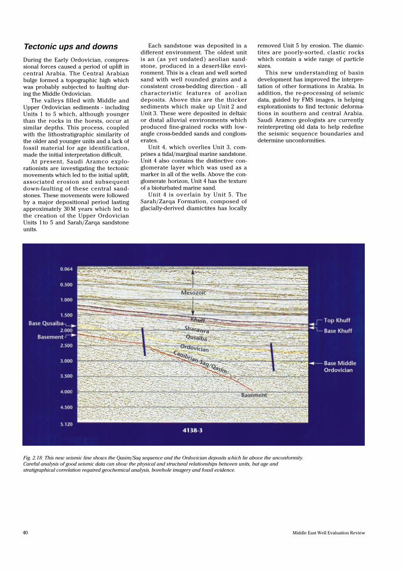
Fig. 2.18: This new seismic line shows the Qasim/Saq sequence and the Ordovician deposits which lie above the unconformity.
Careful analysis of good seismic data can show the physical and structural relationships between units, but age and
stratigraphical correlation required geochemical analysis, borehole imagery and fossil evidence.
41Number 16, 1996.
More than core
The combination of core analysis and
FMS borehole imagery helped to solve
the correlation problems which Saudi
Aramco faced in central Arabia.
Having established that Units 1 to 5
were of Upper Ordovician age, geolo-
gists had to deduce the depositional his-
tory of these previously unknown
formations. The transition from aeolian
sandstones in Unit 1, through deltaic and
marine sediments to the glacially-
derived rocks of the Zarqa and Sarah
formations, is recorded with great detail
in the FMS borehole images.
In addition, the images have allowed
geologists to separate diagenetic effects
from syndepositional features.
New efforts are being made to define
seismic sequence boundaries (figure
2.18). Re-interpretation of older seismic
data and new acquisition have been
stimulated and guided by the identifica-
tion of unconformities which were
recorded using cores (figure 2.19) and
borehole imagery.
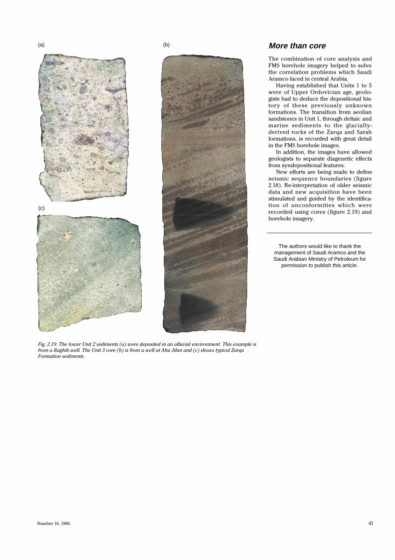
Fig. 2.19: The lower Unit 2 sediments (a) were deposited in an alluvial environment. This example is
from a Raghib well. The Unit 3 core (b) is from a well at Abu Jifan and (c) shows typical Zarqa
Formation sediments.
(a)
(c)
(b)
The authors would like to thank themanagement of Saudi Aramco and theSaudi Arabian Ministry of Petroleum for
permission to publish this article.