sargeant bay park master plan - british columbia · anchorage for mariners travelling the strait of...
TRANSCRIPT

SARGEANT BAY PROVINCIAL PARK
MASTER PLAN
South Coast Region February, 1991


TABLE OF CONTENTS 1.0 PLAN HIGHLIGHTS ...................................................................................................... 1 2.0 INTRODUCTION ............................................................................................................. 3
2.1 PLAN PURPOSE ................................................................................................ 5 2.2 BACKGROUND REPORT SUMMARY............................................................. 5
3.0 THE ROLE OF SARGEANT BAY PARK ................................................................... 6
3.1 REGIONAL AND PROVINCIAL CONTEXT..................................................... 6 3.2 CONSERVATION ROLE ................................................................................... 6 3.3 RECREATION ROLE .......................................................................................... 6
4.0 PARK ZONING ............................................................................................................... 8 5.0 NATURAL AND CULTURAL RESOURCE MANAGEMENT.................................10
5.1 INTRODUCTION................................................................................................10 5.2 NATURAL RESOURCE MANAGEMENT POLICIES...................................10
6.0 VISITOR SERVICES MANAGEMENT ......................................................................13
6.1 INTRODUCTION ...............................................................................................13 6.2 VISITOR OPPORTUNITIES.............................................................................13 6.3 MANAGEMENT SERVICES.............................................................................15 6.4 PROMOTIONS AND INFORMATION PROGRAM.......................................15
7.0 PLAN 1MPLEMENTATION ........................................................................................16 APPENDIX 1 - BACKGROUND DOCUMENT.......................................................................17 APPENDIX 2 - WETLAND REHABILITATION PROPOSAL ..............................................18 APPENDIX 3 - PUBLIC INVOLVEMENT PROCESS SUMMARY ....................................19 APPENDIX 4 - PHOTOGRAPHS ...........................................................................................20

1
2
1.0 PLAN HIGHLIGHTS • The Master Plan stresses the importance of Sergeant Bay Provincial Park to residents and
tourists of the Sunshine Coast. Resource Management initiatives include: • protecting the park land base by acquiring foreshore and peripheral property • enhancing the park's wetland environment for vegetation and wildlife habitat by initiating
marshland rehabilitation proposals Visitor Services Management initiatives include: • providing safe vehicular and pedestrian access from Redrooffs Road • developing picnic sites along the beachfront • providing nature trails and wildlife viewing opportunities • providing overnight camping opportunities
Sargeant Bay will be promoted as a natural park area; all development will take advantage of the site's special features and their importance for public use and appreciation.

3

4
2.0 INTRODUCTION
Sargeant Bay Provincial Park, 8 km west of Sechelt, is located central to most of the population on the Sunshine Coast. The park attracts day-use from throughout the region, and is fast becoming a popular beachfront stop for tourists travelling on Highway 101.
First proposed in 1975, Sargeant Bay Park has long been of interest to BC Parks and the local community. The Sargeant Bay Society, formed from local residents who wished to see the private property acquired by the Government, was instrumental in raising the profile and awareness of the site's important recreation and conservati on value. Since park establishment in 1990, the Society has retained significant interest in Sargeant Bay Park planning and development; the Background Document for the Master Plan was produced by the group.
Long-time residents of the Sunshine Coast have witnessed tremendous pressure on their recreation resources. The Sunshine Coast has rapidly become a get -away and easy commute for the growing Vancouver population; it’s inherent attractiveness is enhanced by a peaceful, oceanfront atmosphere. The establishment of Sargeant Bay Park, like other parks of the Sunshine Coast, has created an instant demand for park facilities. However, the natural resources of Sargeant Bay Park attract a special range of visitor and must be protected. Conserving these resources, while providing facilities to meet the demands for recreation on the Sunshine Coast, presents a management challenge.

5

6
2.1 PLAN PURPOSE
This Master Plan provides the 5-year Management Strategy for Sargeant Bay Provincial Park. It presents park-spec ific policies for resource conservation and visitor facility development - the guideline from which BC Parks formulates its planning, conservation and visitor services program initiatives. 2.2 BACKGROUND REPORT SUMMARY • climate of the park is generally dry, sunny, moderately warm • situated at the head of Sargeant Bay with a southeastern aspect, not particularly sheltered from
winds off Georgia Strait • a 40m wide barrier berm separates the 400m gravel sand and gravel beach from the 9 ha marsh • Redrooffs road bisects the park; the oceanside 1/3 of the park includes the marsh; the upland 2/3
is forested • two creeks enter the park, intersect, then drain through the marsh and berm to Sargeant Bay • most of the park is second growth fir, cedar, hemlock and pine mixed with maple and alder • bear, deer, raccoons, skunk, squirrel, mink, bats, beavers, loons, ducks, herons, rails, blackbirds,
garter snakes • beach is the focus for recreational use, upland areas are used for hiking and birdwatching • the park protects the natural feature of the barrier beach and associated freshwater marsh • the beach is a key recreational asset to the Sunshine Coast • recreation opportunities are Resource Appreciation, Beach/Waterplay/Picnic, Boating and
Camping • use of the property has increased since becoming Provincial Park; fishing and beach activity • potential to draw visitors from Vancouver is obvious • significant park issues: marsh enhancement, Redrooffs Road alignment and park access,
provision of camping
7
3.0 THE ROLE OF SARGEANT BAY PARK 3.1 REGIONAL AND PROVINCIAL CONTEXT
For the expanding residential population of the Sunshine Coast, Sargeant Bay Park provides beachfront access and water recreation opportunities. The park is centrally located on the Sechelt Peninsula, thus making it accessible on a day basis for most residents and their guests.
The Sunshine Coast traditionally attracts Lower Mainlanders for summer sunshine destination holidays. Dependent on ferry connections to both the Mainland and Vancouver Island, the Sunshine Coast/Sechelt Peninsula represents an easy "get away" from B.C.'s most urbanized area.
As a Travel Corridor, Highway 101 serves the resident and tourist population travelling by automobile between Gibsons and Powell River. Increasing bicycle touring on the Sunshine Coast has prompted more use to the quiet, off highway road system. Recreational mariners travelling up and down the coast have long recognized the attractiveness of Sargeant Bay for day visits. 3.2 CONSERVATION ROLE
Sargeant Bay Provincial Park is located within the Gulf Islands unit of BC Parks’ Regional
Landscapes system. Owing to the relatively small size of the park however, no significant contribution is made to the Landscape Representation goal of BC Parks.
The park certainly contains natural and cultural features that are of local/regional importance, although no significant contribution is made to the provincial Outstanding Features goal of BC Parks. The conservation of recreation opportunities, particularly waterfront recreation and marsh wildlife viewing, is an important role of Sargeant Bay Park.
Sargeant Bay Provincial Park conserves features appropriate for outdoor recreation as well as wildlife habitat associated with Georgia Strait and the Sunshine Coast.
3.3 RECREATION ROLE
Sargeant Bay Park has been an important BC Parks interest area for many years. The 1975 System plan for the Sunshine Coast planning unit identified Sargeant Bay as "the last remaining beach lot on Georgia Strait with sufficient length of beach and adjacent upland for development of a seaside campground".
Residents of Sechelt recognize the immense value of Sargeant Bay Park and utilize the property on a day basis. In addition, tourists travelling the Coast Highway use the park for picnics and rest stops. Vancouverites, used to very few beach access points along the Sunshine Coast, welcome the opportunity to enjoy the beach and foreshore area presented at Sargeant Bay. Sargeant Bay provides a day-use anchorage for mariners travelling the Strait of Georgia. Camping facilities will enhance its destination attributes and augment the few overnight camping opportunities available on the Sunshine Coast.
Sargeant Bay Provincial Park provides important day-use and overnight outdoor recreation opportunities to ser ve both residents and tourists on the Sunshine Coast.

8
4.0 PARK ZONING
Figure 4 illustrates the zoning plan for Sargeant Bay Park. Zone designations define appropriate uses and levels of development for all areas of a park. For Sargeant Bay:
Intensive Recreation: A majority of the park is zoned to provide for the development and promotion of outdoor recreation opportunities, including the day-use area and future campground.
Special Feature: The marsh is an important natural feature of the park with capability for wildlife habitat enhancement and outdoor education.

10

11
5.0 NATURAL AND CULTURAL RESOURCE MANAGEMENT 5.1 INTRODUCTION
The natural and cultural resources of Sargeant Bay Park contribute to its recreational importance to both residents and tourists on the Sunshine Coast. Effective park management will ensure that these resources remain for continued public benefit. 5.2 NATURAL RESOURCE MANAGEMENT POLICIES
(Figure 5) Land Management Objective:
To ensure that the designated park area continues to protect the site's important recreational and natural values.
Actions:
• Acquire the Sargeant Bay foreshore to a point suitable for protecting offshore moorage and swimming areas.
• Initiate negotiations to acquire the "big rock" portion of Lot A, Plan 15810 (see Appendix 1 -
Background Document).
• Encourage and support Regional District network road plans that would bypass the Park. Water Management Objective:
To ensure that the quantity and high quality of water flowing through Sargeant Bay Park is retained.
Actions:
• Rehabilitate the beach barrier berm thereby re-establishing the pre-1977 water flow pattern through Sargeant Bay Park.
• Formulate a spillway op erations plan to control the (proposed) pond level.
• Prior to campground development, complete an assessment of the hydrological impact of
campground construction and operation on Colvin Creek, Unnamed Creek and the marsh.
• Request assurance from the Regional District that impacts to park hydrology be thoroughly assessed prior to issuing development permits adjacent to Sargeant Bay Park.
• Ensure that park developments do not impair water resources.
• Enforce BC Parks regulations regarding discharge of marine holding tanks within park
boundaries.

12

13
Wildlife Management Objective: To encourage fish and wildlife to use Sargeant Bay Park by protecting and enhancing natural terrestrial and marine habitats.
Actions:
• Permit the Sargeant Bay Society to undertake a marsh rehabilitation and enhancement project for purposes of encouraging wetland species to reside and nest within the park; the development plan is presented as Appendix 2 of the Master Plan.
• Retain a hunting and shooting closure over the park.
• Conserve raptor perching trees within the park.
• Protect the current level of beaver population within the park.
• Ensure Colvin and Unnamed Creeks remain unblocked, thereby protecting cutthroat trout
spawning activity.
• Retain a commercial shellfish harvesting closure over the beach and foreshore of the park; continue to permit recreational harvesting as per Federal regulation.
Vegetation Management Objective:
To retain the natural vegetation of Sargeant Bay Park. Actions:
• Encourage the rehabilitation of marshland vegetation species (see Wildlife Management and Appendix 2)
• Remove excess fill from the beach barrier berm to allow natural species to revegetate.
• Design and construct park trails, picnic areas and other facilities with due sensitivity to the
natural vegetation cover.
• Manage hazard trees per BC Parks policy. Cultural Resource Management Objective:
To identify and protect important cultural or heritage resources in the park. Actions:
• Provide archaeological analysis of the breached beach berm, and fill material, prior to its reconstruction.
• Contact and encourage individuals or groups interested in Sargeant Bay to research
interpretive material relative to its cultural history.

13

14
6.0 V1SITOR SERVICES MANAGEMENT 6.1 INTRODUCTION
Natural and cultural features of Sargeant Bay Park maintain significant recreation value. The park is attractive to a wide range of visitors: sunbathers, picnickers, boaters, walkers, bird watchers, nature buffs - as family groups, senior citizen clubs, naturalist organizations, school classes and individuals - from Sechelt Peninsula, the Sunshine Coast, Vancouver Island and the Lower Mainland. It is incumbent on BC Parks to provide facilities and opportunities that will optimize the visitor's experience while maintaining the natural beauty of Sargeant Bay Park and the local area. 6.2 VISITOR OPPORTUNITIES
(Figure 6) a) Park Access Objective:
To facilitate safe and convenient access within the park, including provision for the disabled. Actions:
• Relocate the beach road entranceway to a point 100m eastward on Redrooffs Road, thus providing a safe intersection and pedestrian crossing point.
• Reconstruct and widen the beach road.
• Provide perpendicular day-use parking for approximately 50 vehicles along the access road.
• Provide adequate drop-off facilities for car-top boats, groups and the disabled.
• Improve the trail between Redrooffs and Northwood Road to facilitate pedestrian and bicycle
access from Welcome Woods.
• Encourage, over the long term, adjacent property owners who utilize the park road to construct alternate property access.
b) Beach/Waterplay/Picnic Objectives:
To provide for beachfront, day-use recreation for residents and tourists on the Sunshine Coast. Actions:
• Install pit toilets at each end of the beach.
• Provide water from Municipal supplies.
• Provide for picnicking along the beach barrier, complete with tables, some of which will accommodate wheelchairs.
15
• Construct a day-use shelter.
• Provide for small (car-top) boat unloading. c) Resource Appreciation Objective:
To facilitate and promote the use of Sargeant Bay Park for nature study , outdoor education and resource appreciation.
Actions:
• Support the Wetland Rehabilitation initiative of the Sargeant Bay Society, including proposals for trails and wildlife viewing areas.
• Construct a trail which links the marsh area to the Redrooffs Road pedestrian crossing. (see
Access)
• Provide seasonal Nature Interpretation/Education services (eg. volunteer visitor programs, self-guided trails) upon completion of the wetland rehabilitation project.
d) Camping
Development of a campground at Sargeant Bay will augment the number of camping sites on the Sunshine Coast and increase opportunities for families from the Sechelt area to participate in this activity.
Objective:
To provide overnight camping opportunities for residents and tourists on the Sunshine Coast. Actions:
• Complete a campground design within the Intensive Recreation zone. Determine capacity and scale of development based on site assessment, in particular:
- hydrological impacts on the marsh - surface water runoff pattern - ground water levels - suitability for septic tank systems
• Develop campground facilities to accommodate:
- bicycle tent camping - hike in tent camping - auto camping

16
6.3 MANAGEMENT SERVICES
Sergeant Bay Park is managed as part of the Sunshine Zone of the Garibaldi/Sunshine Coast District. 6.4 PROMOTIONS AND INFORMATlON PROGRAM Objective:
To promote Sargeant Bay Park as a "natural recreation area" where elements of the wildlife, marine and vegetation resources are presented for public appreciation.
Actions:
• Include Sargeant Bay Park in marketing initiatives for Sunshine Coast Provincial Parks.
• Provide standard highway signing to direct visitors to the park.
• Prepare an Information Package for Sargeant Bay Park that includes: - in-park regulatory signs - an information shelter - Interpretive signing
• Encourage continued cooperation with the Sargeant Bay Society and other interest groups,
particularly when formulating Interpretation plans and programs related to the park's natural and cultural resources.
• Integrate Sargeant Bay Park into Interpretation programming at other parks on the Sunshine
Coast.
• Within the Annual Park Management Plan: - devise methods to encourage local media and civic organizations to promote public
appreciation for the natural qualities of Sargeant Bay Park. - identify programs to promote use of the park by groups, particularly school classes,
seniors and nature clubs. - conceive special community events based on the park's natural resources.

17
7.0 PLAN IMPLEMENTATION
The following schedule is intended to facilitate implementation of the Master Plan. Priority 1:
Planning
• acquire foreshore • monitor Redrooffs road realignment plans
Resource Conservation
• rehabilitate barrier berm • facilitate wetland rehabilitation project • prepare a spillway operations plan
Visitor Services
• relocate park entrance • construct parking and turnaround area • install sanitary facilities • provide potable drinking water to day -use area • install picnic tables along beach berm • complete campground design assessments
Priority 2:
Planning
• monitor land use adjacent to the park
Resource Conservation
• assemble cultural history of the park
Visitor Services
• improve trail through to Northwood Road • construct a day -use shelter • complete trails and Interpretive facilities • construct campground

i
Contents Introduction v 1 Natural and Cultural Resources 1
1.1 Natural Resources .............................................................................................................1 1.1.1 Climate ..................................................................................................................1 1.1.2 Physiography.........................................................................................................1 1.1.3 Geology.................................................................................................................3 1.1.4 Soils.......................................................................................................................3 1.1.5 Vegetation .............................................................................................................4 1.1.6 Wildlife .................................................................................................................4 1.1.7 Outdoor Recreation Features ................................................................................8 1.1.8 Visual Qualities.....................................................................................................9
1.2 Cultural Resources ............................................................................................................9 1.3 Resource Analysis ...........................................................................................................11
2 Tenures, Occupancy Rights and Jurisdictions 12
2.1 Leases and Use Permits ...................................................................................................12 2.2 Rights-of-way..................................................................................................................12 2.3 Mineral Tenures ..............................................................................................................12 2.4 Fee simple land holdings ................................................................................................14 2.5 Forest Tenures ................................................................................................................14 2.6 Trespasses .......................................................................................................................14 2.7 Water Rights ...................................................................................................................16 2.8 Foreshore Rights .............................................................................................................16 2.9 Special Regulations.........................................................................................................16 2.10 Statutory Jurisdictions.....................................................................................................16
3 Recreation Opportunities 18
3.1 Resource Appreciation....................................................................................................18 3.1.1 Birds....................................................................................................................18 3.1.2 Marine Life .........................................................................................................18 3.1.3 Plants ...................................................................................................................18
3.2 Beach/Waterplay/Hiking.................................................................................................19 3.2.1 Fishing.................................................................................................................19 3.2.2 Swimming ...........................................................................................................19

ii
3.2.3 Sailboarding ........................................................................................................19 3.2.4 Picnicking............................................................................................................19 3.2.5 Hiking..................................................................................................................19
3.3 Boating............................................................................................................................19 3.4 Camping ..........................................................................................................................20
4. Market Analyses 21
4.1 Existing Use ....................................................................................................................21 4.2 Promotion and Informa tion.............................................................................................21 4.3 Future Use .......................................................................................................................21
5 Master Plan Issues 22
5.1 Park Role.........................................................................................................................22 5.2 Resource Protection and Enhancement...........................................................................22 5.3 Roads and Access............................................................................................................23
5.3.1 Redrooffs Road ...................................................................................................23 5.3.2 Beach Access ......................................................................................................23
5.4 Park Facility Development..............................................................................................23 5.4.1 Parking ................................................................................................................23 5.4.2 Camping ..............................................................................................................24
5.5 Park Boundary.................................................................................................................24 5.5.1 The Foreshore .....................................................................................................24 5.5.2 The Big Rock ......................................................................................................24
5.6 Boat Launch....................................................................................................................24
iii
List of Figures 1 Sargeant Bay Provincial Park – Location..............................................................................vi 2 Sargeant Bay Provincial Park - Regional Setting .................................................................vii 1.1 Topographical Plan of Sargeant Bay Park ..............................................................................2 1.2 Approximate Soils Distribution..............................................................................................3 1.3 Types of Vegetation................................................................................................................6 1.4 Outdoor Recreation Features ................................................................................................10 2.1 Sargeant Bay Park - Cadastral Plan - Scale: 1:6000 .............................................................13 2.2 Sargeant Bay Provincial Park - Local Setting.......................................................................15

iv
Acknowledgements The author acknowledges Tony Greenfield for contributing the section on birds, Eric Hoare for his useful comments and suggestions and Kory Conwright and Bryan Carson for proofreading the manuscript.
Thanks are due also to Judy Skogstad and Bob Patrick of the Sunshine Coast Regional District's Planning Group, for providing some of the source material and, in particular, for checking the sections on geology and occupancy rights.
Drew Carmichael, Doug Leavers and Rik Simmons have been most helpful in providing the necessary guidance to make the report conform to B.C. Parks' standard format and for discussing it in detail. Al Jenkins’ help in providing the archaeological information is also much appreciated.
Finally, the author wishes to thank Mel Turner, B.C. Parks’ Manager of Planning and Conservation, and Peggy Conner, SCRD Chairman, for their continued interest in this subject.

v
Introduction Sargeant Bay Provincial Park is situated on the Sunshine Coast, 8 km west of Sechelt, (see Figures 1 and 2) and comprises a diverse foreshore and forest area at the head of Sargeant Bay. The park area includes a 400 m long sand and gravel beach, a wetland, a salmon bearing creek, forest and an impressive view of the Trail Islands across Sargeant Bay, one of the better fishing spots on the Coast.
Because of its varied topography, the park has the potential to support a wide variety of outdoor activities, ranging from beach-combing, marine life observation, birdwatching and hiking, to fishing, scuba-diving, windsurfing canoeing, swimming, picnicking and camping.
The first negotiations between the owner and B.C. Parks about acquisition of the beach area
took place in 1965. B.C. Parks listed the area in a survey of the Sunshine Coast for potential park sites in 1975. [1]. In subsequent years there have been several rounds of negotiations with the developers, who owned the land. The area was finally purchased by the Ministry of Crown Lands in October 1989 and dedicated as a Class “A” Provincial Park in 1990.
This report describes the area in some detail, in order to provide the necessary background
information for the development of a masterplan. It follows closely the format used by B.C. Parks for background reports on other provincial parks.

vi

vii

1
Chapter 1
Natural and Cultural Resources 1.1 Natural Resources 1.1.1 Climate The climate in the park is typical for the immediate coastal regions of the Strait of Georgia, that is, moderate with respect to both temperature and rainfall. Snow is rare but ground frost is not unusual in the early mornings in winter. Even though the maximum elevation in the park is only 80 m, there are noticeable temperature differences between the beach and the higher elevations. The statistics for this region are as follows[2]:
Mean Annual Precipitation: 75-100 cm Number of days with measurable precipitation in January: 14-17 Number of days with measurable precipitation in July: 6-9 Mean Daily Temperature in January: >50C Mean Daily Temperature in July: 16-180C Average frost-free period: >220 days Average hours of sunshine: 1600-1800 [3]
In summary, the climate is characterized by dry, sunny, moderately warm summers and
almost snow-free winters. These climatic conditions make the Sunshine Coast an attractive area for year-round recreational activities. 1.1.2 Physiography The Sargeant Bay Park is situated at the head of Sargeant bay, which faces south-east towards the Trail Islands in the Strait of Georgia. A topographical plan of the park is shown in Figure 1.1. The north-eastern shore of the bay is rock, the south-western shore is sand and gravel. The head of the bay consists of a 400 m long sand-and-gravel beach. Where the beach and the rocky shore meet, just outside the site boundary, is a 30 m high rock, which dominates the scenery. Parallel to the beach is a 40 m wide barrier berm, that separates the beach from a 9 ha marsh. Approximately two-thirds of the marsh is fresh, one-third is tidal.

2

3
A public road, Redrooffs Road, divides the park into a foreshore and an upland area. The
foreshore area is approximately 13 ha, which includes the marsh. The upland area of approximately 44 ha is covered with forest and is mostly rocky. There are several old logging roads in that area, as well as an abandoned road between Redrooffs Road and Northwood Road and an abandoned road for a once-planned residential sub-division.
Two creeks enter the park through the north boundary, run through culverts under Redrooffs Road and feed the marsh. The larger creek is named Colvin Creek, the smaller one is unnamed. Both join downstream of the marsh and discharge into Sargeant Bay through a man-made channel. There is a waterfall in Colvin Creek, just upstream from Redrooffs Road. 1.1.3 Geology Geological processes that began 600 million years ago, have shaped the Sunshine Coast into a coastal mountain landscape with rugged scenic appeal. Former sea beds of the Palaeozoic era (600-230 million years ago) were uplifted by volcanic intrusions of the Mesozoic era (230-63 million years ago). This time of mountain building involved massive uplifting that created the granite batholiths which form the Coast Ranges. The rocks within the park are part of this system [4].
The immediate foreshore, the beach and marsh area, have a much more recent history. The bluff shoreline between Reception Point and Sargeant Bay represents an erosion shore, oriented obliquely into a predominant south-west wave energy zone. The drift-sector of that shoreline extends from the west entrance headland of Sargeant Bay to Reception Point with a net westerly drift. At the same time, the west shore of Sargeant Bay experiences considerable wave penetration and shore erosion due to its orientation and narrow near-shore shelf. The result is an active one-way drift-sector where material moves rapidly into the head of the bay, where it created an accretion rollback barrier berm and tidal lagoon. The lagoon eventually silted up and became an almost entirely freshwater marsh. The marsh and barrier-beach shorescape form a unique system that represents an outstanding example of bio-physical integration [5]. 1.1.4 Soils While a detailed soils study has not been made, some general information is available from the Halfmoon Bay Community Plan Technical Background Report [4]. Some more information is available on the foreshore area between Redrooffs Road and Sargeant Bay from a preliminary study by SCS Engineering Ltd.[6] in support of a sub-division proposal by the previous owner.
The upland area north-east of Colvin Creek consists primarily of Bedrock outcrops, mostly bare rock with thin patches of overburden, usually till or marine veneer. The area south-west of Colvin Creek consists primarily of Pre-Vashon sediments, gravel, sand and silt. These two surficial systems, roughly separated by the Colvin Creek valley, are characterized by the shape of the contour lines on Figure 1.1: The contour lines in the north-eastern area are curvaceous, indicating rocks, while those on the south-western boundary are almost straight and clearly a continuation of the nearby shore slope.
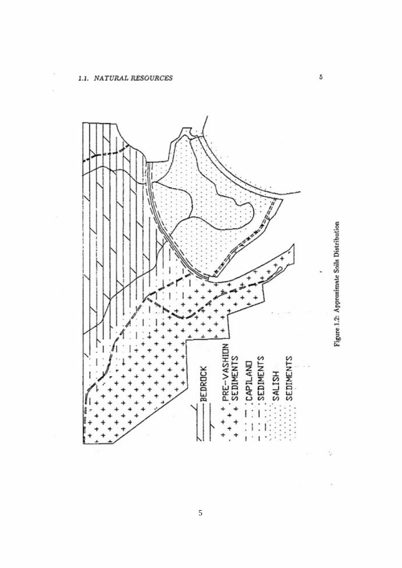
4
The Colvin Creek valley consists of Capilano sediments, fluvial sediments, consisting of cobbles, gravel, sand and silt. The marsh and the berm along the beach consist of Salish sediments, loam, sand and gravel, deposited recently by fluvial action. The approximate soils distribution is shown in Figure 1.2. 1.1.5 Vegetation Forest Most of the park is covered with second growth forest consisting of Douglas Fir, Western Red Cedar, Western Hemlock, Lodgepole Pine and a few Sitka Spruce, mixed with Broadleaf Maple, Red Alder and Bitter Cherry. The area was logged in 1910 and the average age of trees is 80 years. Some trees in the area just north of the park, which was selectively logged in 1986, showed an age of 100 years, when cut. Dominant undergrowth species are Salal, Salmonberry and Thimbleberry. This vegetatio n covers all of the park, except the marsh, and strips along the abandoned roads from Redroofs Road to Northwood Road and in the once-planned subdivision in the south.
The strip along the abandoned road between Redrooffs and Northwood, which must have been built in the early sixties, is covered with Red Alder, as is the strip along the road in the area that was cleared for a subdivision in 1980. Wetland The predominant vegetation in the wetland consists of Hardhack, Twin Berry various kinds of Willow, Cattails, Sedges and Bulrushes. Part of the wetland was dredged in 1977, and is now subject to flooding at high tide. There, the vegetation does not include Cattails. The bay There are eelgrass beds just below the tidal zone and various kinds of brown seaweeds on the rocks. Farther out in the bay one can find Bladder Kelp. The big rock The big rock at the end of the beach, just outside the park boundary, features a typical coastal rock vegetation, which includes the Chocolate Lily. The distribution of types of vegetation is shown in Figure 1.3. 1.1.6 Wildlife Mammals Land mammals Black Bear and Black-tailed Deer are seen regularly. Raccoons, Spotted Skunk , Douglas Squirrel, Bushy Tail Rats and White Footed Mice are common. River Otters are seen regularly in the bay and have also been seen in Colvin Creek near Redrooffs Road. Mink can be seen on the beach. Flying Squirrels are not often seen, but do occur, as do various species of bats.
5

6
7
Beavers settled in Colvin Creek in 1988 and in the unnamed creek in 1989. The dams they built are quite long because the terrain is essentially flat. The streams are not dammed completely. Only enough water is diverted to feed the ponds. Both ponds are just upstream of the marsh and each includes a small lodge. So far, the beavers have not done much damage to the trees and seem to subsist mostly on willows. The dam in the unnamed creek will probably kill some large coniferous trees that are flooded. Marine mammals Sargeant Bay provides opportunity for viewing marine mammals: Killer Whales pass by in the Strait of Georgia and a White-sided Dolphin was observed in the bay in 1987. Northern Sea Lions have been observed occasionally and one was found dead on the beach. Harbour Seals are common in the bay and have a colony on a rock near the Trail Islands. Birds Water birds Many of the marine birds of the Strait of Georgia can be closely viewed within the confines of Sargeant Bay, such as several species of Loons, Grebes, Cormorants, Ducks, Mergansers, Gulls, Terns and Alcids. Great Blue Herons can usually be seen on the beach. Ospreys are summer visitors and a pair of Bald Eagles nest every year on the east side of the bay, outside the park. Marsh birds The present marsh habitat is home to three characteristic species - resident Virginia Rails and summer visitors Red-winged Blackbirds and Common Yellowthroats. Dippers can be seen in the creek. Forest birds The mixed deciduous/coniferous forest of the uplands attracts all the characteristic species of the Coast Forest, including raptors, Blue and Ruffed Grouse, 5 species of woodpeckers, 4 of owls, 5 of flycatchers, 4 of vireos and 8 of warblers. Other notable species are Western Tanager and Black-headed Grosbeak. Reptiles The three species of garter snakes that are common on this coast, also occur in the park. They are: the Puget Garter Snake, the North-western Striped Garter Snake and the Coast Garter Snake. The latter can often be seen on the beach, basking in the sun or catching small crabs. Amphibians Tree Frogs and Red-legged Frogs have been found in the park. Frogs and Rough-skinned Salamanders are reported to have lived in the freshwater pond behind the berm, before the channel was dredged out. Around the mid-seventies a chorus of frogs could be heard across the bay, coming from the marsh. The disappearance of the frogs in the marsh is a mystery.

8
Fish There are some small Cutthroat Trout in the upland section of Colvin Creek, somewhat surprising, as this is upstream of the waterfall. Chum Salmon spawn in the dredged, tidal section of the creek and Coho fry has been observed there.
Sport fishing has always been popular in Sargeant bay. Some of the species commonly caught are Dogfish, Lingcod, Copper Rockfish, Kelp Greenling, Coho, Chum, Chinook and Spring Salmon.
Small fish in the tidal zone include Shiner Perch, Kelp Perch, Stickle Back, Pipe Fish, Blackeye Goby, Cockscomb Prickleback, Penpoint Gunnel, Rockweed Gunnel, Copper Rockfish, Herring, Salmon Fry, Kelp Greenling, White-spotted Greenling, Tidepool Sculpin, Fluffy Sculpin, Sailfin Sculpin, Sand Lance, Pacific Sanddab, Starry Flounder, C-O Sole and Spiny Lumpsuckers. Invertebrates Barnacles, Edible Mussels and Pacific Oysters grow on the intertidal rocks. The oysters are usually collected before they reach full size . Myriads of tiny Checkered Periwinkles can often be found grazing on these rocks. The cobbles near the low-tide mark are also covered with colourful Calcareous Tubeworms.
The sandy beach hides thousands of Heart Cockles and Butter Clams, and near the low-tide mark, the Moon Snails that prey on them. Also burrowing in the sand are numerous Ghost Shrimps and Lugworms. The Buried Green Anemone also lives in the sand but is always attached to a cobble under the sand.
The bay is also the home of a several sea star species. The Purple Star is the most abundant, and the Leather Star and Sunflower Star are common.
The Shore Crab is abundant under the cobbles, even when the tide is out. The edible Dungeness Crab lives in the eelgrass beds. The colourful Paguras Crab, a hermit crab that prefers to use empty moon shells, normally stays below the low tide line.
Of the Nudibranchs the Hooded Nudibranch is common in the eelgrass beds and the Sea Lemon can be found on the rocks.
To see some of the marine life below the tidal zone, scuba gear is necessary. There are California Sea Cucumbers on the sandy bottom and Geoducks buried in the sand. The latter have been harvested commercially in 1988 at the deeper end of the bay. 1.1.7 Outdoor Recreation Features Sargeant Bay Provincial Park contains a variety of outdoor recreation features of local and province-wide significance[7]. At present the main focus of the area is the beach, which has been used for swimming and picnicking for many years, particularly by families with children. Now the area has become a park, the natural barrier berm has become available as an additional picnic site and for viewing the wildlife in the bay and in the marsh.

9
The beach has also been used, probab ly even longer, by sport fishermen to launch small boats, many of them rowboats. More recently, these have been joined by canoeers, kayakers, windsurfers and scuba-divers. Occasionally, waterskiers come into the bay from off-shore. The bay also provides a good opportunity for the study of inter-tidal marine life.
The marsh behind the berm is the major feature of the park, with a characteristic wetland vegetation that supports a variety of small birds. However, the nature of the wetland makes access very difficult and it is only enjoyed by a few hardy birdwatchers.
The creek that runs through the marsh provides an opportunity for watching salmon spawn in the fall.
The south-western half of the forested upland area includes the abandoned road to Welcome Woods and the aborted subdivision road. The alder transition forest that has sprung up on both sides of these roads hides the fairly old second growth further back. The north-eastern half of the forest is suitable for hiking and nature study. It includes Colvin Creek, most of which, including the waterfall, is relatively undisturbed. The north-eastern half of the forest is very rocky and because it is second growth, the undergrowth is very dense. Access is difficult in the absence of hiking trails, altho ugh some old logging roads can be used to good advantage.
The park's main outdoor recreation features are indicated in Figure 1.4. The significance rating is considered in isolation and compared to the best on a province-wide scale. Therefore, few features are rated very high. However, on a local scale they are significant and, considering the variety of features combined in a relatively small area, the park's recreation features are highly significant. 1.1.8 Visual Qualities Sargeant Bay Beach provides impressive scenery. Looking out to the Trail Islands on a clear day, Mount Baker can be seen on the horizon. Many visitors to the beach climb the rock at the end of the beach, which provides an even better view of the north-east shore of the bay and across the Strait of Georgia with Forbidden Plateau on Vancouver Island in the background.
1.2 Cultural Resources Little is known about the early human history of the park area. During the dredging in 1977 some Indian artifacts were discovered. The immediate area of the channel dredged through the berm has since been registered as an archaeological site[8].
In 1889 Districts Lot 1324 was sold to a Frederick Sargeant for $1324. At the time the area was logged, in the early part of the century, a sawmill was located at the
mouth of Colvin Creek. Part of an old steam engine boiler is still exposed at low tide above the mud in the little lagoon.
For many years Mr. and Mrs. Ford ran a resort at Sargeant Bay, a remnant of which still exists and was, until recently, still occupied. The earliest aerial photographs are from 1932

10

11
and show some cabins on the beach berm. Those photographs show a pond inside the berm opposite the lagoon into which the creek discharged. The photographs were taken at low tide, so there must already have been a dam at that time, probably man-made.
In 1937 there was a boathouse on the beach, built against the big rock, which was then owned by Mr. and Mrs. Clegg. The boathouse still shows up on 1958 aerial photographs.
Redrooffs Road was probably built in 1956, as it shows up on 1957 aerial photographs, but void of any signs of development. They also show the pond inside the berm. Art Angell bought the property around 1962. He dredged the channel through the berm in 1977 in an attempt to dredge an in-shore marina[11] and demolished some of the old resort cabins around 1983. 1.3 Resource Analysis The park protects an outstanding natural feature - a distinct barrier beach and associated freshwater marsh - on the Sunshine Coast and provides outdoor recreation opportunities for both tourists and residents. The area has been strongly affected by man, which can be compensated for by proper management and cautious rehabilitation and enhancement.
Sargeant Bay beach is a key recreational asset to the Sunshine Coast, where public beach access has become severely restricted due to residential ribbon development along the shore. The area's scenic beauty is beyond question.
Local interest to acquire the area as a regional park has always been high. For years, a local group (the Sargeant Bay Society) has tried to secure local government or private funding from every conceivable source - with much sympathy and moral support, but without success until the Ministry of Crownland bought the area for a Provincial Park.

12
Chapter 2
Tenures, Occupancy Rights and Jurisdictions
2.1. Leases and Use Permits There are no leases or land use permits issued in Sargeant Bay Park.
2.2 Rights-of-way The Ministry of Transportation and Highways has a right-of-way for Redrooffs Road, a major collector road, which is registered but has not been surveyed[9].
There is a 20 m wide right-of-way for public beach access from Redrooffs Road and Kenyon Road due south to the big rock. This right-of-way allows public access to the park and the lagoon behind the rock.
There is a 1.5 m wide right-of-way between Lot 11, Plan 16088, and the beach. This right-of-way has been intersected by the channel, dredged in 1977.
The SCRD watermain for Welcome Woods runs along the abandoned road between Redrooffs Road and Northwood Road. This right-of-way has been surveyed but is not registered.
These right-or-way corridors are shown in Figure 2.1. The road from Redroofs Road to the beach in the south of the park is not a right-of-way but is entirely within the park boundaries. Eastwood Road in Welcome Woods is just outside the west park boundary. 2.3 Mineral Tenures There are no mineral tenures within the park boundaries.

13

14
2.4 Fee simple land holdings At the south-west park boundary are 16 residential lots in Welcome Woods that have a common boundary with the park.
Wedged between Redrooffs Road and the road to the beach are 9 residential lots with a boundary in common with the park. These lots have direct road access to Redrooffs Road. Lot 10 and one other lot in that series, however, have driveways that access onto the beach road, which may constitute a property line infringement.
There are also five residential lots which have a common boundary at the east of the park. Lot A, plan 15810 includes the big rock.
DL 1624, on the north park boundary, is owned by a company for which Mr. John Hammond is the spokesman. He has indicated that he wants to apply for sub-division into residential lots and is presently logging on that property.
The location of these lots is shown in Figure 2.1
2.5 Forest Tenures There are no forest tenures within the park boundaries. DL 1623 is crownland under the jurisdiction of the B.C. Forest Service. This lot has a common boundary with part of the park's north boundary as shown in Figure 2.1. Most of the lot has been clear-cut in 1985 and replanted in 1987. The eastern section, at the park boundary, however, has not been logged.
North of DL1623 is the Sechelt Forest, which is also under the jurisdiction of the B.C. Forest Service. The Sechelt Forest is important for the park as it has potential for an interesting hiking trail to a pristine little lake, about 1.5 km north of the park. The lake is the source of the unnamed creek that runs through the park. It is surrounded by a sphagnum bog and is an untouched, ecologically pure plant community that is rare this close to civilization. The lake was re-discovered by members of the Sargeant Bay Society in 1989, at the request of the SCRD Community Planner. The lake, its watershed and a forested corridor for an access trail starting at the Sargeant Bay Park have been identified in the Halfmoon Bay Community Plan as a future public recreation area[l0].
The Sechelt Forest is shown in Figure 2.2. 2.6 Trespasses For many years local residents have been storing small fishing boats on the beach berm near the beach road. This has been allowed by the previous owner along with the use of the beach road as favour to those who purchased residential properties from him. Without such permission, such use could be considered a trespass.

16
2.7 Water Rights There are no water licences or rights issued within the park,
2.8 Foreshore Rights There are no foreshore leases issued within the park. 2.9 Special Regulations A shellfish closure is in force in Sargeant Bay over a 300 m radius from the mouth of Colvin Creek[l2].
2.10 Statutory Jurisdictions Local Government: Sunshine Coast Regional District
P.O. Box 800 Sechelt B.C. V0N 3A0
Roads: Ministry of Transportation and Highways 1790 Main Street North Vancouver, B.C. V7J 1E3
Sewage: Coast Garibaldi Health Unit
5571 Inlet Street Sechelt, B.C. V0N 3A0
DL 1623 Ministry of Forests Sechelt Forest: Powell River District
7077 Duncan St. Powell River, B.C. V8A 1W1
Archaeology: Ministry of Municipal Affairs
Recreation and Culture Heritage Conservation Branch 333 Quebec Street Victoria, B.C. V8V 1X4

17

18
Fish & Wildlife: Ministry of the Environment 10334-152A Street Surrey, B.C. V3R 7P8
Salmonid Enhancement: Fisheries & Oceans
P.O. Box 10 Madeira Park, B.C. V0N 2H0
Streams: Ministry of Environment
Regional Water Manager 10334-152A Street Surrey, B.C. 43R 7P8
Foreshore: Ministry of Environment Regional Land Manager 10334-152A Street Surrey, B.C. V3R 7P8

19
Chapter 3
Recreation Opportunities 3.1 Resource Appreciation As Sections 1.1.5 and 1.1.6 may suggest, there is ample opportunity for the study of nature in the park. In the following paragraphs this outdoor activity will be discussed in some detail[7]. 3.1.1 Birds Opportunities for birdwatching exist throughout the park and during all seasons. Bay and shore birds can best be viewed from the beach berm, during fall, winter and spring. In spring one can usually watch newly hatched Common Mergansers and Canada Geese. The marsh birds can also best be watched from the beach berm. One can usually hear, and if one is lucky, or armed with a tape-recorder, one may even see the Virginia Rails.
Raptors and passerine birds can be watched from Redrooffs Road and from the old logging roads in the upland area. In the longer term, bird-watching opportunities can be enhanced by building more trails and a board-walk through the marsh. 3.1.2 Marine Life For those who engage in scuba-diving, the study of marine life is a year-round activity. Others have to make use of the low tides. Very low tides occur year-round, but only during the summer they happen during the day, which makes the summer the better season for this activity. 3.1.3 Plants Those interested in plants will find a wide variety of habitats that can be enjoyed: from the seaweeds in the tidal zone to the salt- loving flora on the berm, the fresh water marsh vegetation and forest vegetation during summer and mushrooms in fall.

20
3.2 Beach/Waterplay/Hiking 3.2.1 Fishing Sportfishing has, of course, been the earliest recreational activity in this area. As many as 40 small boats have been counted in the bay in some good winters. The logs that float onto the beach at about every high tide don't seem to deter the average sport fisherman. 3.2.2 Swimming The beach is one of the few on the Sunshine Coast that is good for swimming. During the lower tides the gently sloping sandy beach is exposed, which makes it quite safe for children. At high tide the much steeper coble beach is under water, which makes it possible to actually swim close to the beach. 3.2.3 Sailboarding During calm weather Sargeant Bay is a good bay for learning this relatively new sport. Those with enough experience may prefer to wait for a south-eastern breeze, or go out into Georgia Strait, where there is always enough wind and the waves provide more challenge. 3.2.4 Picnicking The beach berm is an excellent site for beach tables, which are expected to make the park very popular for family picnics. 3.2.3 Hiking The upland area and beyond is the better area for hiking. The wildlife and vegetation in the area will turn a hike into more than just a walk in the forest. Once a proper trail system has been implemented, none of the hikes will be particularly difficult or long. 3.3 Boating Here, as discussed under Fishing, the boats one sees most in the bay are small enough to be carried: row-boats, canoes, kayaks, and small sailboats. The Trail Islands are just about the limit of where they can go, although most stay in the bay. The relative absence of bigger powerboats seems to be attractive to the owners of these man- and wind-powered craft.
Cabin cruisers and sail yachts often drop anchor in the bay for the night. However, Sargeant Bay is only recommended for anchorage in calm weather because of its exposure to south-east storms[l3].

21
During very calm weather the bay is suitable for water-skiing, but this is done only
occasionally, behind boats that come in from off-shore.
3.4 Camping Opportunity for camping in Sargeant Bay Park is limited. The most suitable area would seem to be in the upland area south-west of Colvin Creek.
22
Chapter 4
Market Analyses 4.1 Existing Use Until recently, use of the park area was severely limited because it was privately owned. Therefore, past use is not a valid quantity from which to extrapolate future use. The road to the beach was entirely on private property, but local residents have used it, with permission from the one-time owner.
On warm summer days 10-20 cars could be seen parked at the beach, mostly from families spending a few hours on the beach. During the rest of the year 2-5 cars from fishermen was about the norm, although, at times when the fishing was good, up to 40 boats could be counted on the bay. The rate of usage always peaked on weekends.
During the last few years the Sargeant Bay Society organized marine life interpretation fieldtrips. These were advertised in a newsletter to members, in the local papers and on cable TV, and were attended by about 100 people.
4.2 Promotion and Information From experience with the advertised marine life fieldtrips one may expect that promotion and information will have a dramatic effect on park attendance.
On the Sunshine Coast it is now generally known that the area has become a provincial park and during the winter months the number of people seen walking on the beach has been increasing steadily. Once the site has been restored to its natural state, use of the beach area will increase substantially.
Until such time any promotional effort would be premature. 4.3 Future Use With the variety of features the park has to offer, one may expect that the park will attract many visitors from the immediate area, the rest of the Sunshine Coast and the Lower Mainland. It is expected that the park will attract a fair number of tourists, who stay at other campgrounds or in hotels on the Sunshine Coast.

23
Chapter 5
Master Plan Issues The preceding chapters have shown that Sa rgeant Bay Provincial Park includes an area with very diverse and attractive features. However, because of encroaching residential sub -divisions and the area's history at the hands of a developer, a number of issues need to be addressed in the Master Plan. These are identified in the following sections: 5.l Park Role The role of the park needs to be assessed relative to the park's sensitive natural features and the demand for outdoor recreation facilities on the Sunshine Coast.
5.2 Resource Protection and Enhancement Preservation of the natural environment and protection of wildlife are “very important” to over 90% of park users and 85% of the public at large, according to the public perception survey of 1989[14]. Therefore, preservation of the upland forest and the marsh behind the beach should have high prio rity.
The Sargeant Bay Society has offered to play a leading role in the preservation, enhancement, management and interpretation of the natural resources in the park. The Society’s first priority is the implementation of a Wetland Rehabilitation and Enhancement Project for the marsh. They have secured funding from the Habitat Conservation Fund for the planning of the project and have been advised that they are also eligible for a grant from the Environmental Partners Fund once the implementation phase is reached.
The Society may also undertake the development of trails in the upland fores t with help of the Environment Youth Corps. They are also promoting the case for a trail to the small lake 1.5 km north of the park and on to Trout Lake as discussed in section 2.5. Such a trail would be located in the only area adjacent to the park that is not already residential or threatened to become so. The Society intends to approach the B.C. Forest Service for permission to develop the trail and to obtain a commitment that the surrounding forest will not be logged.

24
5.3 Roads and Access 5.3.1 Redrooffs Road Redrooffs Road is an undesirable but unavoidable right-of-way. The owner of DL 1624 has indicated that be intends to apply for a sub-division on that lot with access through the park from Redrooffs Road. That would only aggravate this situation and sacrifice a substantial amount of park property. DL 1624 does have direct access to Highway 101.
It is likely that, sooner or later, the Ministry of Transportation and Highways will want to straighten Redrooffs Road in the east corner of the park, where the road bends around a rock outcropping, creating a traffic hazard. Such a move will have to be accepted and sacrifices only a small amount of park property.
The intersection of the beach road with Redrooffs Road is hazardous. One solution would be to move the intersection further east, so the beach road intersects Redrooffs Road at a right angle. The other solution would be to purchase Lot 10, Plan 12224 and bend the beach road westward, which would have the same effect. 5.3.2 Beach Access As identified in Section 2.4, Lots 2-10, Plan 12224 in Figure 2.1 have a common boundary with the beach road park boundary. Lot 3 has a permanent residence and Lot 2 has a summer cottage. Both lots have driveways on Redrooffs Road. For Lots 4-10, which are unimproved, access to Redrooffs Road is steep and difficult. Two of these lots already have driveways from the beach road.
The beach access road is presently used by the owners of lots 1, 2 and 4, Blk. 1, DL 1325 to reach their cottages via the beach. They may consider any access or parking restrictions on this road an inconvenience. The lots do have direct legal access to Redrooffs Road, but lots 2 and 4 are too steep to construct a driveway.
The barrier berm is firm and in perfect condition for vehicle access. However, traffic on the berm would have a negative impact on the marsh as a wild life sanctuary, spoil the quiet atmosphere at the bay and degrade the berm as a picnic area. Therefore, traffic on the berm should be restricted to Official Park U se Only.
5.4 Park Facility Development 3.4.1 Parking Presently, visitors to the beach park their cars at the end of the beach access road. There is an obvious need for car access at that point, so park visitors can drop off their picnic gear or launch their boats. However, the establishment of an official parking lot would have a negative impact on the aesthetic quality of the area. The construction of parking space along the beach road, but out of sight from the beach should receive serious consideration.
25
5.4.2 Camping A campground would be possible in the flatter area south-west of Colvin Creek. There are large rock outcroppings on other side of the creek, which do not show on the topographic plan, Figure 1.1, and may make that area less suitable.
Sewage disposal for a campground would have to be looked into carefully, as drainage in the area is poor. This was one of the reasons why an application for rezoning to allow a residential sub-division in that area, was rejected.
Public acceptance by residents of the surrounding neighbourhoods may also need to be considered. Some concerns were expressed at the recent Sargeant Bay Society's Annual Meeting and in a letter-to-the-editor in one of the local papers.
5.5 Park Boundary 5.5.l The Foreshore To obtain control over the foreshore and to prevent others from gaining such control, applying for a Foreshore Lease should be considered. 5.5.2 The Big Rock The big rock in the north corner of the bay, as described in Sections 1.1.2 and 1.1.7 is a popular feature of the beach. Many people climb it to enjoy the scenery and vegetation. As identified in Section 2 it is part of Lot A, Plan 15810. The rock would be a valuable addition to the park. For the owner, keeping park visitors off the rock is an impossible task. There is also the burden of liability, as the north-east side of the rock is a cliff with a 30 m vertical drop. The owner may consider selling the rock, or perhaps, exchanging it for the north half of the 20 m road allowance from Redrooffs Road, which has become redundant since Kenyon Road was built. 5.6 Boat Launch Many years ago the Sechelt Rod and Gun Club installed a boat ramp consisting of concrete slabs. By 1973 the ramp had totally disintegrated. Since then public boat ramps have been installed at Selma Park, 10 km to the east, and at Coopers Green, 5 km to the west.
At present, boats on trailers can be launched with 4-wheel drives, except at low tide. A concrete boat ramp would make this possible for all cars with boats on trailers. Such a ramp would also make the bay accessible to bigger boats. The problem of logs floating onto the ramp at every high tide would still remain.
Questions that need to be addressed are: Should the bay be made more accessible for bigger boats which may cause more pollution? and: Should the Park Administration undertake to keep such a ramp clear of logs?

26
Bibliography [1] Sunshine Unit Plan,
Ministry of Lands, Parks and Housing, 1975. [2] Atlas of British Columbia, People, environment and resource use,
A.L. Farley, 1979. [3] An Economic Base Study of the Sunshine Coast Peninsula Region,
Environment Canada and Strong, Hall and Assoc., 1980. [4] Halfmoon Bay Plan Area Technical Background Report,
Judy Skogstad, Sunshine Coast Regional District, March 1990. [5] Report on Sunshine Coast Shore Erosion,
Wolf Bauer P.E., March 1977. [6] Preliminary Report on Geotechnical Aspects,
SCS Engineering Ltd. for Sargeant Bay Marina Corp., March 1986. [7] The natural heritage of Sargeant Bay,
Jessie Lafeber, Peninsula Times, July 1979. [8] British Columbia Archaeological Site Inventory Form: Site No. DiRx4,
Mapsheet 92 G/5 West Half. [9] Cadastral Plan SCRD-807 92G.041.4.3 [10] Halfmoon Bay Official Community Plan,
Judy Skogstad, Sunshine Coast Regional District, Second Reading, December 1989. [11] Present Status and Recommended Action,
Donald R. Guthrie, Report to the Regional Land Manager, October 1978. [12] Shellfish Growing Water Sanitory Survey,
Report EPS 5-PR-74-12, November, 1974 [13] Pacific Yachting's Cruising Guide to B.C., Vol. III, Sunshine Coast ,
Bill Wolferstan, 1982. [14] B.C.Parks Public Perception Survey
BC Parks Newsletter, Vol. 1, No. 1, March, 1990.
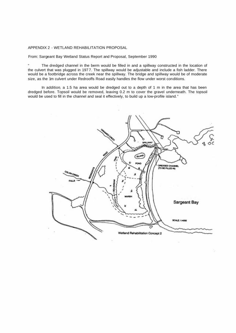
APPENDIX 2 - WETLAND REHABILITATION PROPOSAL From: Sargeant Bay Wetland Status Report and Proposal, September 1990
“ The dredged channel in the berm would be filled in and a spillway constructed in the location of the culvert that was plugged in 197 7. The spillway would be adjustable and include a fish ladder. There would be a footbridge across the creek near the spillway. The bridge and spillway would be of moderate size, as the 1m culvert under Redrooffs Road easily handles the flow under worst conditions.
In addition, a 1.5 ha area would be dredged out to a depth of 1 m in the area that has been
dredged before. Topsoil would be removed, leaving 0.2 m to cover the gravel underneath. The topsoil would be used to fill in the channel and seal it effectively, to build up a low-profile island.”

APPENDIX 3 - PUBLIC INVOLVEMENT PROCESS SUMMARY
The Planning Project Terms of Reference (approved May,1990) outlined a process for public involvement in the Sargeant Bay Provincial Park Master Plan.
The Sargeant Bay Society prepared the Master Plan Background Document, which was approved by BC Parks. The Draft Master Plan was then prepared and: - released to interest groups within Sunshine Coast communities.
- copies distributed to community libraries and the Government Agent's office. - summarized and released to community newspapers and media. - released to Regional District and District Municipal officials. - presented at an Open House held in Sechelt. - displayed at a Sec helt shopping mall.
Approximately 160 persons attended the 1-day Open House presentation at Rockwood Lodge in
Sechelt. Over 30 comment forms were returned to BC Parks.
Summary of Public Comments: - re-evaluate policies relative to access (to adjacent private property). - consider boat launching facilities for trailers. - review proposals for trails encircling the wetland project. - consider hike-in/bike-in camping only.
In general the plan was extremely well received and endorsed by the ge neral public, by the
organized interest groups, and by the local government agencies and municipalities.

APPENDIX 4 - PHOTOGRAPHS
PHOTOGRAPHS NOT AVAILABLE