sap 4 habitats regulations assessments appendices · in-vessel composting . this composts garden...
TRANSCRIPT

APPENDIX 1
TYPES OF WASTE MANAGEMENT FACILITIES
Household Waste Recycling Centres
These are provided by the County Council in its role as the waste disposal authority. Modern ones comprise a number of covered bays where people can take bulky household items and recyclable and non-recyclable materials that are not collected by the bin lorries or kerbside collections. Sites of approximately one hectare are usually needed.
Types of waste treatment facilities
These are usually within buildings and would be likely to require sites between 2 and 3 hectares.
Waste Transfer and Bulking Stations
These are where waste is delivered for bulking up before being sent to a larger facility or where it is sorted prior to being transferred somewhere else for recycling, treatment or disposal.
Materials Recovery Facility (MRF)
This is a dedicated facility for the sorting and separation of recyclable materials. It can be expected to handle around 50,000 tonnes/year. At present these are primarily for municipal waste. However, they are likely to be needed for the much larger commercial and industrial waste streams.
Mechanical and Biological Treatment (MBT)
This is a generic term for mechanical sorting and separation used in conjunction with biological treatment processes such as composting. They dry out and reduce the bulk of the waste and separate it into recyclables such as metals and glass, an organic fraction, and sometimes biogas or a refuse derived fuel or a soil conditioner. There is also usually a reject fraction which will require landfill disposal. The refuse derived fuel can be used in an Energy from Waste Plant or may be able to be used in an existing industrial process such as a cement kiln but not in power stations.
MBT plants would probably have modules of around 50.000 tonnes/year. Their buildings could be 140 metres long and 30 metres wide.
Anaerobic digestion
Biodegradable waste is placed in an enclosed vessel and encouraged to break down in the absence of oxygen. The end products are a solid or liquid digestate which may be able to be used as a soil conditioner or a bio-fertiliser, a concentrated liquor which can be re-circulated, or may be able to be used as a fertiliser or disposed through sewage treatment works, and a methane rich biogas. This gas can be burnt to generate electricity and counts as a renewable fuel.
HRA of Site Allocation Policies and Proposals Map Regulation March 2010 41

Energy from waste plants (EfW)
These are usually within buildings on sites of between 2 and 4.5 hectares
There are several different technologies for these. They burn residual waste in controlled conditions to generate heat and/or electricity, after targeted levels of recyclables and biodegradable wastes have been removed. Ideally these plants should be combined heat and power plants and be located near a development that would use the waste heat (normally steam), and where the electricity generated can be fed into the National Grid. They could have capacities ranging from 20,000 to 200,000 tonnes/year. Anaerobic digestion, described above, can also involve energy generation.
Advanced thermal treatment plants
These incorporate advanced or emerging technologies. They include pyrolysis where organic materials are broken down by heat in the absence of oxygen. The process produces a synthetic gas or pyrolysis oil which can be used to generate electricity. A solid char is also produced which may need specialist disposal or additional processing.
An alternative is gasification which operates at a higher temperature than pyrolysis and with oxygen or air and added water. It produces a synthetic gas with a higher hydrogen content than pyrolysis. A solid residue is produced which usually requires landfill disposal.
Mechanical Heat Treatment is another generic option. It can involve pre-treating waste prior to separation by heat or steam, for example in an autoclave. It can be part of the MBT process. It can produce a refuse derived fuel as well as the recyclables. There will be a residue that requires landfill disposal.
There are also other advanced thermal treatment technologies.
Landfill
After the removal of recyclables and compostable materials there is still usually a residual fraction of waste that has to be landfilled.
Aerobic digestion
This is a biological process in which biodegradable wastes are decomposed by micro-organisms in the presence of air. It is usually described as composting which can be either in open windrows or within an enclosed vessel (see below). The residue may be used as a soil conditioner or mulch or sold as a compost.
Open windrow composting
This is a process in which garden wastes are piled in rows usually in the open air but sometimes inside a building. It produces a stabilised compost, water and carbon dioxide. It cannot be used for food wastes. Sites should not be located close to sensitive properties because of odour problems.
HRA of Site Allocation Policies and Proposals Map Regulation March 2010 42
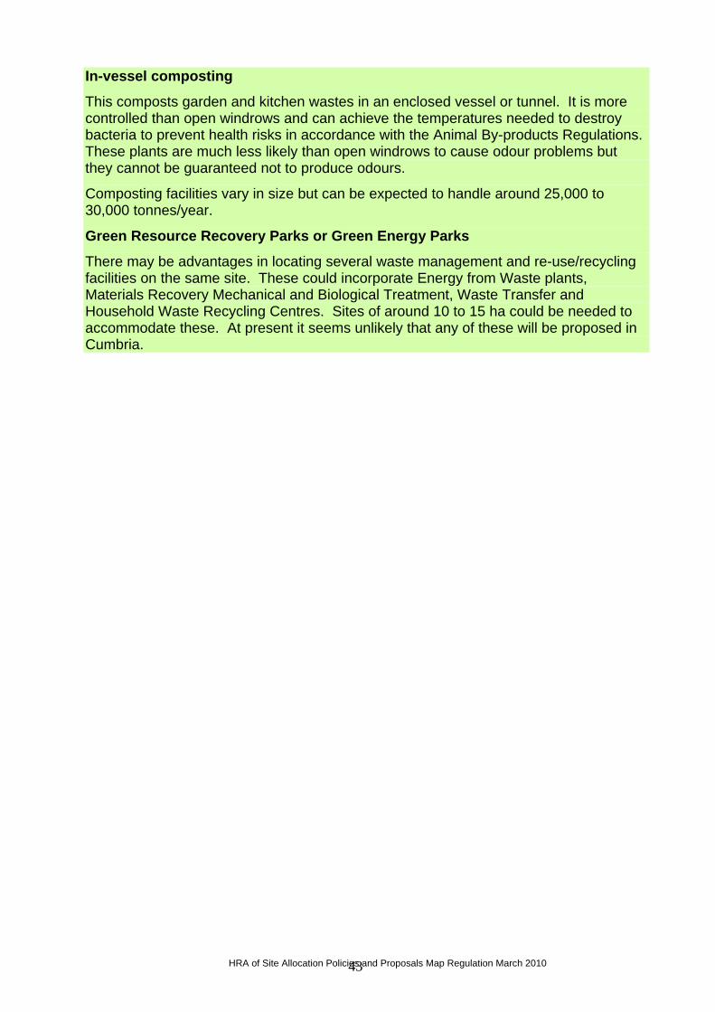
In-vessel composting
This composts garden and kitchen wastes in an enclosed vessel or tunnel. It is more controlled than open windrows and can achieve the temperatures needed to destroy bacteria to prevent health risks in accordance with the Animal By-products Regulations. These plants are much less likely than open windrows to cause odour problems but they cannot be guaranteed not to produce odours.
Composting facilities vary in size but can be expected to handle around 25,000 to 30,000 tonnes/year.
Green Resource Recovery Parks or Green Energy Parks
There may be advantages in locating several waste management and re-use/recycling facilities on the same site. These could incorporate Energy from Waste plants, Materials Recovery Mechanical and Biological Treatment, Waste Transfer and Household Waste Recycling Centres. Sites of around 10 to 15 ha could be needed to accommodate these. At present it seems unlikely that any of these will be proposed in Cumbria.
HRA of Site Allocation Policies and Proposals Map Regulation March 2010 43
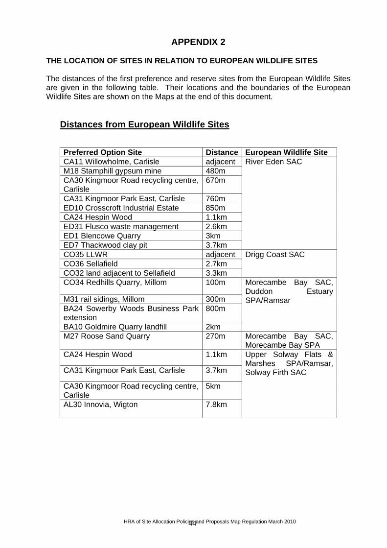
APPENDIX 2 THE LOCATION OF SITES IN RELATION TO EUROPEAN WILDLIFE SITES The distances of the first preference and reserve sites from the European Wildlife Sites are given in the following table. Their locations and the boundaries of the European Wildlife Sites are shown on the Maps at the end of this document.
Distances from European Wildlife Sites
Preferred Option Site Distance European Wildlife Site CA11 Willowholme, Carlisle adjacent M18 Stamphill gypsum mine 480m CA30 Kingmoor Road recycling centre, Carlisle
670m
CA31 Kingmoor Park East, Carlisle 760m ED10 Crosscroft Industrial Estate 850m CA24 Hespin Wood 1.1km ED31 Flusco waste management 2.6km ED1 Blencowe Quarry 3km ED7 Thackwood clay pit 3.7km
River Eden SAC
CO35 LLWR adjacent CO36 Sellafield 2.7km CO32 land adjacent to Sellafield 3.3km
Drigg Coast SAC
CO34 Redhills Quarry, Millom 100m
M31 rail sidings, Millom 300m BA24 Sowerby Woods Business Park extension
800m
BA10 Goldmire Quarry landfill 2km
Morecambe Bay SAC, Duddon Estuary SPA/Ramsar
M27 Roose Sand Quarry 270m Morecambe Bay SAC, Morecambe Bay SPA
CA24 Hespin Wood 1.1km
CA31 Kingmoor Park East, Carlisle 3.7km
CA30 Kingmoor Road recycling centre, Carlisle
5km
AL30 Innovia, Wigton
7.8km
Upper Solway Flats & Marshes SPA/Ramsar, Solway Firth SAC
HRA of Site Allocation Policies and Proposals Map Regulation March 2010 44

HRA of Site Allocation Policies and Proposals Map Regulation March 2010 45
AL29 Auction Mart, Cockermouth 420m AL18 Port of Workington 1.2km AL3 Oldside, Workington 1.3km M24 Derwent Howe slag bank 2km AL17 Solway Road, Workington 2.2km AL32 Siddick rail sidings 2.4km AL31 Lillyhall landfill site 2.8km AL8 Lillyhall waste management centre
3.4km
AL35 Risehow Industrial Estate 3.4km AL34 Alcan complex 4km CO1 Whitehaven Commercial Park 6.8km
River Derwent and Bassenthwaite Lake SAC
M18 Stamphill gypsum mine 3.3km
ED10 Crosscroft Industrial Estate 3.8km
North Pennine Moors SPA, Moor House – Upper Teesdale SAC
SL1 Kendal Fell Quarry 530m Morecambe Bay Pavements SAC
CO11 Bridge End Industrial Estate 2.8km CO1 Whitehaven Commercial Park 4.8km CO36 Sellafield 8.4km CO32 land adjacent to Sellafield 8.5km
River Ehen SAC
SL1 Kendal Fell Quarry 1km River Kent SAC AL30 Innovia, Wigton 3.5km South Solway Mosses
SAC

HRA of Site Allocation Policies and Proposals Map Regulation March 2010

APPENDIX 3
CUMBRIA MINERALS AND WASTE DEVELOPMENT FRAMEWORK
HABITATS REGULATIONS ASSESSMENT
REGULATION 30 SITE ALLOCATIONS POLICIES AND PROPOSALS MAP
THE CONSERVATION OBJECTIVES OF THE EUROPEAN WILDLIFE SITES
HRA of Site Allocation Policies and Proposals Map Regulation March 2010 46

HRA of Site Allocation Policies and Proposals Map Regulation March 2010 47

THE CONSERVATION OBJECTIVES OF THE EUROPEAN WILDLIFE SITES Part 1 European Sites and Features – SACs
1 This is the approximate central point of the SAC - in the case of large, linear or composite sites, this may not represent the location where a feature occurs within the SAC * Priority feature
EUROPEAN SITE
GRID REF1/ AREA
REASON(S) FOR DESIGNATION CONSERVATION OBJECTIVES SITE ALLOCATIONS
Asby Complex SAC
NY598112 3122.23 ha
Annex I Habitats – primary reasons • Semi-natural dry grasslands and scrubland
facies: on calcareous substrates (Festuco-Brometalia)
• Molinia meadows on calcareous, peaty or clayey silt-laden soils (Molinion caeruleae)
• Petrifying springs with tufa formation (Cratoneurion) *
• Alkaline fens • Limestone pavements * Annex I Habitats – qualifying reasons • Hard oligo-mesotrophic waters with benthic
vegetation of Chara spp. • European dry heaths • Calcareous fens with Cladium mariscus and
species of the Caricion davallianae * Annex II Species – primary reasons • Geyer’s whorl snail Vertigo geyeri • Slender green feather-moss Drepanocladus
(Hamatocaulis) vernicosus
In relation to Crosby Ravensworth Fell SSSI - subject to natural change, to maintain the following habitats and geological features in favourable condition, with particular reference to any dependent component special interest features (habitats, vegetation types, species, species assemblages, etc.) for which the land is designated. Habitat Types represented (Biodiversity Action Plan categories) o Upland heath o Upland (limestone) grassland o Calcareous flushes Species represented o Vascular plant assemblage Geological features (Geological SiteTypes) o Surface Karst (IC) SAC habitats represented o Hard water springs depositing lime o Calcium-rich spring water fed fens o Calcium-rich fens dominated by great fen sedge o Limestone grassland o Dry heath
None.
Bolton Fell Moss SAC
NY490688 374.74 (ha)
Annex I Habitats – primary reasons • Active raised bogs * • Degraded raised bogs still capable of natural
regeneration
N/A – nearest site is CA24 Hespin Wood, near Carlisle, which lies 12km away.
Border Mires, Kielder – Butterburn SAC
NT684013 11851.77 ha cross border with
Annex I Habitats – primary reasons • Blanket bogs * • Transition mires and quaking bogs Annex I Habitats – qualifying reasons
None
HRA of Site Allocation Policies and Proposals Map Regulation March 2010 48

Northumbria • Northern Atlantic wet heaths with Erica tetralix • European dry heaths • Petrifying springs with tufa formation
(Cratoneurion) * Borrowdale Woodland Complex SAC
NY235129 667.83 (ha)
Annex I Habitats – primary reasons • Old sessile oak woods with Ilex and Blechnum
in the British Isles Annex I Habitats – qualifying reasons • Siliceous rocky slopes with chasmophytic
vegetation • Bog woodland *
N/A – nearest site is AL29 Auction Mart, Cockermouth, which lies 13.5km away.
Clints Quarry SAC
NY161357 12.03 (ha)
Annex II Species – primary reasons • Great crested newt Triturus cristatus
N/A – nearest site is AL29 Auction Mart, Cockermouth, which lies 7.6km away.
Cumbrian Marsh Fritillary Site SAC
NY400409 22.96 (ha)
Annex II Species – primary reasons • Marsh fritillary butterfly Euphydryas (Eurodryas,
Hypodryas) aurinia
N/A – nearest site is ED7 Thackwood proposed Clay Pit, which lies 6km away.
Drigg Coast SAC
SD071960 1397.44 (ha)
Annex I Habitats – primary reasons • Estuaries • Atlantic decalcified fixed dunes (Calluno-
Ulicetea) • Dunes with Salix repens ssp. argentea (Salicion
arenariae) Annex I Habitats – qualifying reasons • Mudflats and sandflats not covered by seawater
at low tide • Salicornia and other annuals colonising mud
and sand • Atlantic salt meadows (Glauco-Puccinellietalia
maritimae) • Embryonic shifting dunes • Shifting dunes along the shoreline with
Ammophila arenaria (`white dunes`) • Fixed dunes with herbaceous vegetation (`grey
dunes`) * • Humid dune slacks
In relation to Drigg Coast SSSI – subject to natural change, to maintain the following habitats and geological features in favourable condition, with particular reference to any dependent component special interest features (habitats, vegetation types, species, species assemblages, etc.) for which the land is designated. Habitat Types represented (Biodiversity Action Plan categories) o Saltmarsh o Sand dune (vegetated shingle, fixed dune grassland,
humid dune slacks, strandline, embryo and mobile dunes, dune heathland)
Species represented o Amphibian Assemblage o Natterjack Toad o Wintering ringed plover o Vascular plant assemblage o Odonata Assemblage SAC habitats represented o Atlantic decalcified fixed dunes o Atlantic salt meadows o Dunes with creeping willow o Embryonic shifting dunes
Site CO35 Low Level Waste Repository near Drigg is a first preference for the management of low level and very low level radioactive waste, and lies adjacent to the SAC. Site CO36 land within Sellafield is a first preference for the management of low level and very low level radioactive waste, and lies 2.7km from the SAC. Site CO32 land adjacent to Sellafield is a reserve for the management of low
HRA of Site Allocation Policies and Proposals Map Regulation March 2010 49

o Estuaries o Fixed dunes with herbaceous vegetation o Humid dune slacks o Mudflats and sandflats not covered by seawater at low
tide o Salicornia and other annuals colonising mud and sand o Shifting dunes along the shoreline with Ammophilia
arenaria
level and very low level radioactive waste, and lies 3.3km from the SAC.
Duddon Mosses SAC
SD223853 313.07 (ha)
Annex I Habitats – primary reasons • Active raised bogs * • Degraded raised bogs still capable of natural
regeneration
In relation to Duddon Mosses SSSI - subject to natural change, to maintain the following habitats and geological features in favourable condition, with particular reference to any dependent component special interest features (habitats, vegetation types, species, species assemblages, etc.) for which the land is designated. Habitat Types represented (Biodiversity Action Plan categories) o Fen, Marsh and Swamp: Lowland raised bog o Fen, Marsh and Swamp: Lowland soligenous fen Species represented o Invertebrate assemblage
Site CO34 Redhills Quarry, Millom, is a first preference for a Household Waste Recycling Centre and lies 100m from the SAC. Site M31 Salthouse, near Millom, is identified as a potential railhead to be safeguarded for Ghyll Scaur Quarry, and lies 300m from the SAC.
Helbeck and Swindale Woods SAC
NY784164 136.38 (ha)
Annex I Habitats – primary reasons • Tilio-Acerion forests of slopes, screes and
ravines*
N/A – nearest site is ED10 Crosscroft Industrial Estate, Appleby, which lies 8.5km away.
Lake District High Fells SAC
NY303318 26999.36 (ha)
Annex I Habitats – primary reasons • Oligotrophic to mesotrophic standing waters
with vegetation of the Littorelietea uniflorae and/or of the Isoëto-Nanojuncetea
• Northern Atlantic wet heaths with Erica tetralix • European dry heaths • Alpine and Boreal heaths • Juniperus communis formations on heaths or
calcareous grasslands • Siliceous alpine and boreal grasslands • Hydrophilous tall herb fringe communities of
plains and of the montane to alpine levels • Blanket bogs * • Siliceous scree of the montane to snow levels
(Androsaoetalia alpinae and Galeopsietalia ladani)
• Siliceous rocky slopes with chasmophytic
In relation to Shap Fells SSSI – subject to natural change, to maintain the following habitats and geological features in favourable condition, with particular reference to any dependent component special interest features (habitats, vegetation types, species, species assemblages, etc.) for which the land is designated. Habitat Types represented (Biodiversity Action Plan categories) o Dwarf shrub heath (upland heathland) o Bogs (Blanket bog) o Fen, marsh and swamp (upland flushes, fens and
swamps) o Broadleaved mixed and yew woodland – upland (upland
oakwood) SSSI Species Types represented o Breeding bird assemblage
None
HRA of Site Allocation Policies and Proposals Map Regulation March 2010 50

vegetation • Old sessile oak woods with Ilex and Blechnum
in the British Isles Annex I Habitats – qualifying reasons • Species-rich Nardus grassland, on siliceous
substrates in mountain areas (and submountain areas in continental Europe) *
• Alkaline fens • Calcareous rocky slopes with chasmophytic
vegetation Annex II Species – qualifying reasons • Slender green feather-moss Drepanocladus
(Hamatocaulis) vernicosus
SAC Habitat Types represented o European dry heath o Northern Atlantic wet heaths with Erica tetralix o Blanket bogs o Alkaline fens o Old sessile oak woods with Ilex and Blechnum in the
British Isles Geological features (Geological Site Types) o Active quarries and pits (EA) o River and stream sections (EW)
Moor House – Upper Teesdale SAC
NY799358 38795.99 (ha) cross border with Durham
Annex I Habitats – primary reasons • Hard oligo-mesotrophic waters with benthic
vegetation of Chara spp. • Alpine and Boreal heaths • Juniperus communis formations on heaths or
calcareous grasslands • Calaminarian grasslands of the Violetalia
calaminariae • Siliceous alpine and boreal grasslands • Semi-natural dry grasslands and scrubland
facies: on calcareous substrates (Festuco-Brometalia)
• Molinia meadows on calcareous, peaty or clayey silt-laden soils (Molinion caeruleae)
• Hydrophilous tall herb fringe communities of plains and of the montane to alpine levels
• Mountain hay meadows • Blanket bogs * • Petrifying springs with tufa formation
(Cratoneurion) * • Alkaline fens • Alpine pioneer formations of the Caricion
bicoloris-atrofuscae * • Siliceous scree of the montane to snow levels
(Androsacetalia alpinae and Galeopsietalia ladani)
• Calcareous and calcshist screes of the montane to alpine levels (Thlaspietea rotundifolii)
• Calcareous rocky slopes with chasmophytic vegetation
In relation to Appleby Fells SSSI – subject to natural change, to maintain the following habitats and geological features in favourable condition, with particular reference to any dependent component special interest features (habitats, vegetation types, species, species assemblages, etc.) for which the land is designated. Habitat Types represented (Biodiversity Action Plan categories) o Bogs o Calcareous grassland o Dwarf shrub heath – upland o Montane habitats (montane and boreal heaths) o Fen, Marsh & Swamp o Upland mosaic o Inland Rock (Ledge communities) Species represented o Breeding bird assemblage o Vascular plant assemblage o Gentiana verna o Saxifraga hirculus Geological features (Geological Site Types) o Mines and mine dumps o Inland exposures o Caves and Karst
Site M18 Stamphill gypsum mine is a first preference for gypsum extraction and lies 3.3km from the SAC. Site ED10 Crosscroft Industrial Estate, Appleby, is a first preference for a Household Waste Recycling Centre and lies 3.8km from the SAC.
HRA of Site Allocation Policies and Proposals Map Regulation March 2010 51

• Siliceous rocky slopes with chasmophytic vegation
Annex I Habitats – qualifying reasons • European dry heaths • Limestone pavements * Annex II Species – primary reasons • Round mouthed whorl snail Vertigo genesii • Marsh saxifrage Saxifraga hirculus
Morecambe Bay SAC
SD371697 61506.22 (ha) cross border with Lancashire
Annex I Habitats – primary reasons • Estuaries • Mudflats and sandflats not covered by seawater
at low tide • Large shallow inlets and bays • Perennial vegetation of stony banks • Salicornia and other annuals colonising mud
and sand • Atlantic salt meadows (Glauco-Puccinellietalia
maritimae) • Shifting dunes along the shoreline with
Ammophila arenaria (‘white dunes’) • Fixed dunes with herbaceous vegetation (‘grey
dunes’} * • Humid dune slacks Annex I Habitats – qualifying reasons • Sandbanks which are slightly covered by sea
water all the time • Coastal lagoons * • Reefs • Embryonic shifting dunes • Atlantic decalcified fixed dunes (Calluno-
Ulicetea) * • Dunes with Salix repens ssp. argentea (Salicion
arenariae) Annex II Species – primary reasons
In relation to Duddon Estuary SSSI - subject to natural change, to maintain the following habitats and geological features in favourable condition, with particular reference to any dependent component special interest features (habitats, vegetation types, species, species assemblages, etc.) for which the land is designated. Habitat Types represented (Biodiversity Action Plan categories) o Estuary o Saltmarsh o Littoral sediment o Inshore sublittoral sediment o Littoral rock o Inshore sublittoral rock o Coastal vegetated shingle o Sand dune (Strandline, embryo and mobile dunes,
Fixed dune grassland, Humid dune slacks, Dune heath) o Coastal lagoon Species represented o Aggregation of breeding sandwich tern (Annex 1
species) o Breeding bird assemblage o Aggregations of non-breeding birds o Natterjack toad o Invertebrate assemblage o Vascular plant assemblage Geological features (Geological Site Types) o Active process geomorphological (IA)
Site BA24 Sowerby Woods Business Park, Barrow, is a first preference for a waste treatment facility and lies 800m from the SAC. Site BA10 Goldmire Quarry, Barrow, is a reserve for non-inert landfill and lies 2km from the SAC.
HRA of Site Allocation Policies and Proposals Map Regulation March 2010 52
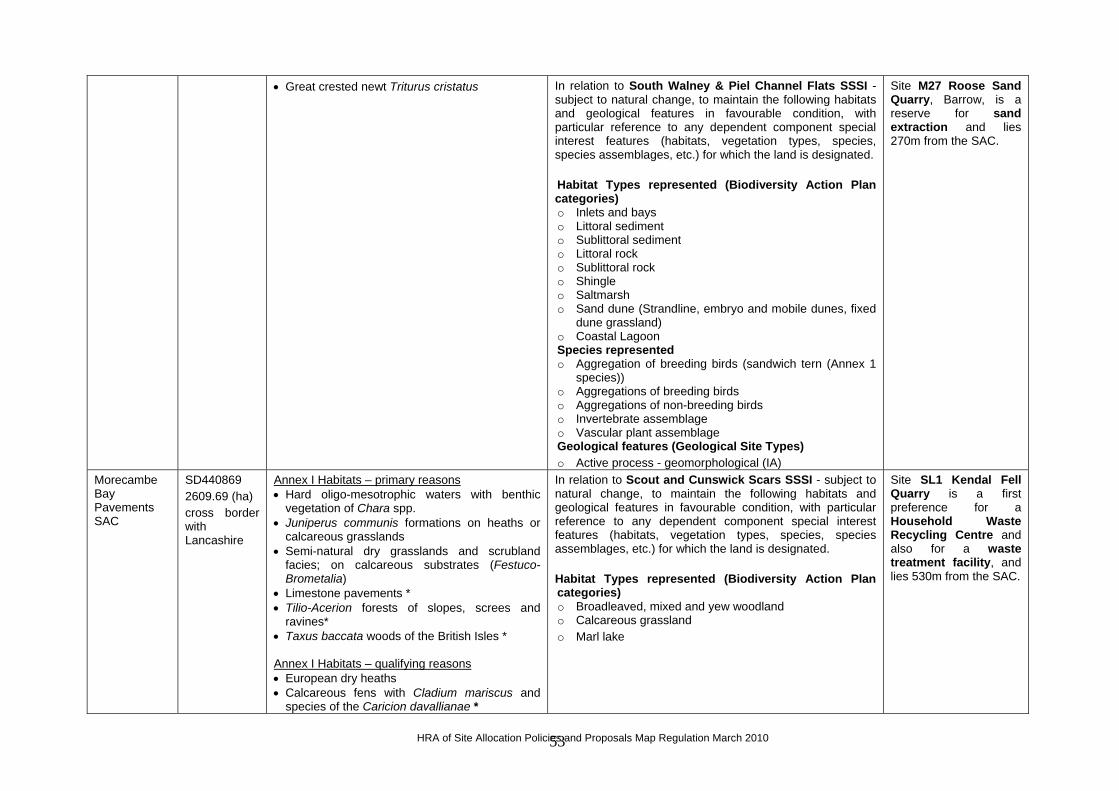
• Great crested newt Triturus cristatus In relation to South Walney & Piel Channel Flats SSSI - subject to natural change, to maintain the following habitats and geological features in favourable condition, with particular reference to any dependent component special interest features (habitats, vegetation types, species, species assemblages, etc.) for which the land is designated. Habitat Types represented (Biodiversity Action Plan categories) o Inlets and bays o Littoral sediment o Sublittoral sediment o Littoral rock o Sublittoral rock o Shingle o Saltmarsh o Sand dune (Strandline, embryo and mobile dunes, fixed
dune grassland) o Coastal Lagoon Species represented o Aggregation of breeding birds (sandwich tern (Annex 1
species)) o Aggregations of breeding birds o Aggregations of non-breeding birds o Invertebrate assemblage o Vascular plant assemblage Geological features (Geological Site Types) o Active process - geomorphological (IA)
Site M27 Roose Sand Quarry, Barrow, is a reserve for sand extraction and lies 270m from the SAC.
Morecambe Bay Pavements SAC
SD440869 2609.69 (ha) cross border with Lancashire
Annex I Habitats – primary reasons • Hard oligo-mesotrophic waters with benthic
vegetation of Chara spp. • Juniperus communis formations on heaths or
calcareous grasslands • Semi-natural dry grasslands and scrubland
facies; on calcareous substrates (Festuco-Brometalia)
• Limestone pavements * • Tilio-Acerion forests of slopes, screes and
ravines* • Taxus baccata woods of the British Isles * Annex I Habitats – qualifying reasons • European dry heaths • Calcareous fens with Cladium mariscus and
species of the Caricion davallianae *
In relation to Scout and Cunswick Scars SSSI - subject to natural change, to maintain the following habitats and geological features in favourable condition, with particular reference to any dependent component special interest features (habitats, vegetation types, species, species assemblages, etc.) for which the land is designated. Habitat Types represented (Biodiversity Action Plan categories) o Broadleaved, mixed and yew woodland o Calcareous grassland o Marl lake
Site SL1 Kendal Fell Quarry is a first preference for a Household Waste Recycling Centre and also for a waste treatment facility, and lies 530m from the SAC.
HRA of Site Allocation Policies and Proposals Map Regulation March 2010 53

• Old sessile oak woods with Ilex and Blechnum in the British Isles
Annex II Species – primary reasons • Narrow-mouthed whorl snail Vertigo angustior
Naddle Forest SAC
NY494144 360.89 (ha)
Annex I Habitats – primary reasons • Old sessile oak woods with Ilex and Blechnum
in the British Isles Annex I Habitats – qualifying reasons • North Atlantic wet heath with Erica tetralix • European dry heaths
None
North Pennine Dales Meadows SAC
NY931256 497.09 (ha) cross border with Durham; Lancashire; North Yorkshire; Northumbria
Annex I Habitats – primary reasons • Mountain hay meadows Annex I Habitats – qualifying reasons • Molinia meadows on calcareous, peaty or
clayey-silt-laden soils (Molinion caeruleae)
In relation to Bretherdale Meadows SSSI - subject to natural change, to maintain the following habitats and geological features in favourable condition, with particular reference to any dependent component special interest features (habitats, vegetation types, species, species assemblages, etc.) for which the land is designated. Habitat Types represented (Biodiversity Action Plan categories) o Upland Hay Meadow (Mountain Hay Meadow) (MG3)
None
North Pennine Moors SAC
SE137749 103109.42 (ha) cross border with Durham; Northumbria; North Yorkshire
Annex I Habitats – primary reasons • European dry heaths • Juniperus communis formations on heaths or
calcareous grasslands • Blanket bogs * • Petrifying springs with tufa formation
(Cratoneurion) • Siliceous rocky slopes with chasmophytic
vegetation • Old sessile oak woods with Ilex and Blechnum
in the British Isles Annex I Habitats – qualifying reasons • Northern Atlantic wet heaths with Erica tetralix • Calaminarian grasslands of the Violetalia
calaminariae • Siliceous alpine and boreal grasslands • Semi-natural dry grasslands and scrubland
facies: on calcareous substrates (Festuco-Brometalia)
• Alkaline fens • Siliceous scree of the montane to snow levels
N/A – nearest site is ED10 Crosscroft Industrial Estate, Appleby, which lies 10.7km away.
HRA of Site Allocation Policies and Proposals Map Regulation March 2010 54

(Androsacetalia alpinae and Galeopsietalia ladani)
• Calcareous rocky slopes with chasmophytic vegetation
Annex II Species – qualifying reasons • Marsh saxifrage Saxifraga hirculus
River Derwent & Bassenthwaite Lake SAC
NY262207 1832.96 (ha)
Annex I Habitats – primary reasons • Oligotrophic to mesotrophic standing waters
with vegetation of the Littorelletea uniflorae and/or of the Isoëto-Nanojuncetea
Annex I Habitats – qualifying reasons • Water courses of plain to montane levels with
the Ranunculion fluitantis and Callitricho-Batrachion vegetation
Annex II Species – primary reasons • Marsh fritillary butterfly Euphydryas (Eurodryas,
Hypodryas) aurinia • Sea lamprey Petromyzon marinus • Brook lamprey Lampetra planeri • River lamprey Lampetra fluviatilis • Atlantic salmon Salmo salar • Otter Lutra lutra • Floating Water-plantain Luronium natans
In relation to River Derwent and Tributaries SSSI - subject to natural change, to maintain the following habitats and geological features in favourable condition, with particular reference to any dependent component special interest features (habitats, vegetation types, species, species assemblages, etc.) for which the land is designated. Habitat Types represented (Biodiversity Action Plan categories) o Rivers and Streams o Standing Open Water (oligotrophic to mesotrophic) o Fen, marsh and swamp o Wet woodland Species represented o Floating water plantain Luronium natans o Vascular plant assemblage o Atlantic salmon Salmo salar o River lamprey Lampetra fluviatilis o Brook lamprey Lampetra planeri o Sea lamprey Petromyzon marinus o Vendace Coregonus albula o Arctic charr Salvelinus alpinus o Otter Lutra lutra o Invertebrate assemblage of fast flowing water o Invertebrate assemblage of mineral marsh and open
water o Invertebrate assemblage of litter-rich fluctuating
wetlands
Site AL29 Auction Mart, Cockermouth, is a first preference for a Household Waste Recycling Centre and lies 420m from the SAC. Site AL18 Port of Workington is a first preference for a waste treatment facility and also for an Energy from Waste plant, and lies 1.2km from the SAC. Site AL3 Oldside, Workington, is a first preference site for a waste treatment facility and also for an Energy from Waste plant, and lies 1.3km from the SAC. Site M24 Derwent Howe slag bank, Workington, is a preferred Mineral Safeguarding Area for secondary aggregates and lies 2km from the SAC. Site AL17 Solway Road, Workington, is a first preference for a Household Waste Recycling Centre and
HRA of Site Allocation Policies and Proposals Map Regulation March 2010 55

lies 2.2km from the SAC. Site AL32 Siddick, Flimby, is identified as a potential railhead to be safeguarded if required in connection with mineral working or waste management proposals, and lies 2.4km from the SAC. Site AL31 Lillyhall landfill site is a first preference for non-inert landfill and lies 2.8km from the SAC. Site AL8 Lillyhall waste management centre is a first preference for a waste treatment facility and also for an Energy from Waste plant, and is a reserve for a Household Waste Recycling Centre, and lies 3.4km from the SAC. Site AL35 Risehow Industrial Estate is a first preference for a Household Waste Recycling Centre and lies 3.4km from the SAC. Site AL34 part of the former Alcan complex, Workington, is a reserve for a waste treatment
HRA of Site Allocation Policies and Proposals Map Regulation March 2010 56

facility and lies 4km from the SAC.
River Eden SAC
NY462237 2463.23 (ha)
Annex I Habitats – primary reasons • Oligotrophic to mesotrophic standing waters
with vegetation of the Littorelletea uniflorae and/or of the Isoëto-Nanojuncetea
• Water courses of plain to montane levels with the Ranunculion fluitantis and Callitricho-Batrachion vegetation
• Alluvial forests with Alnus glutinosa and Fraxinus excelsior (Alno-Padion, Alnion incanae, Salicion albae) *
Annex II Species – primary reasons • White clawed (or Atlantic stream) crayfish
Austropotamobius pallipes • Sea lamprey Petromyzon marinus • Brook Lamprey Lampetra planeri • River lamprey Lampetra fluviatilis • Atlantic salmon Salmo salar • Bullhead Cottus gobio • Otter Lutra lutra
In relation to River Eden and Tributaries SSSI - subject to natural change, to maintain the following habitats and geological features in favourable condition, with particular reference to any dependent component special interest features (habitats, vegetation types, species, species assemblages, etc.) for which the land is designated. Habitat Types represented (Biodiversity Action Plan categories) o Rivers and Streams o Broadleaved, mixed and yew woodland (Wet woodland) o Fen, marsh and swamp (Lowland wetland) o Standing Open Water Species represented o Atlantic salmon Salmo salar o River lamprey Lampetra fluviatilis o Brook lamprey Lampetra planeri o Sea lamprey Petromyzon marinus o Bullhead Cottus gobio o White-Clawed crayfish Austropotamobius pallipes o Schelly Coregonus lavaretus o Otter Lutra lutra o Invertebrate Assemblage o Breeding bird assemblage o Sand martins (breeding) Geological features (Geological SiteTypes) o Karst (IK)
Site M18 Stamphill gypsum mine is a first preference for gypsum extraction and lies 480m from the SAC. Site CA30 Kingmoor Road recycling centre, Carlisle, is a first preference for a waste treatment facility and lies 670m from the SAC. Site CA31 Kingmoor Park East, Carlisle, is a first preference for a waste treatment facility and also for an Energy from Waste plant, and lies 760m from the SAC. Site ED10 Crosscroft Industrial Estate, Appleby, is a first preference for a Household Waste Recycling Centre and lies 850m from the SAC. Site CA24 Hespin Wood landfill, near Carlisle, is a first preference for non-inert landfill and also a reserve for a Household Waste Recycling Centre, and lies 1.8km from the SAC. Site ED31 Flusco
HRA of Site Allocation Policies and Proposals Map Regulation March 2010 57

waste management, near Penrith, is a first preference for a waste treatment facility and lies 2.6km from the SAC. Site CA11 Willowholme, Carlisle, is a reserve for a waste treatment facility and lies adjacent to the SAC. Site ED1 Blencowe Quarry, near Penrith, is a reserve for a waste treatment facility and lies 3km from the SAC. Site ED7 Thackwood proposed Clay Pit, is a reserve for non-inert landfill and lies 3.7km from the SAC.
River Ehen SAC
NY031144 24.39 (ha)
Annex II Species – primary reasons • Freshwater pearl mussel Margaritifera
margaritifera Annex II Species – qualifying reasons • Atlantic salmon Salmo salar
In relation to River Ehen (Ennerdale Water to Keekle Confluence) SSSI - subject to natural change, to maintain the following habitats and geological features in favourable condition, with particular reference to any dependent component special interest features (habitats, vegetation types, species, species assemblages, etc.) for which the land is designated. Habitat Types represented (Biodiversity Action Plan categories) o Rivers and streams (supporting fresh water pearl
mussel) Species represented o Fresh water pearl mussel Margaritifera margaritifera SAC Species represented o Atlantic Salmon Salmo salar
Site CO11 Bridge End Industrial Estate, Egremont, is a first preference for a waste treatment facility and also a reserve for a Household Waste Recycling Centre, and lies 2.8km from the SAC. Site CO1 Whitehaven Commercial Park is a first preference for a Household Waste Recycling Centre, and lies 4.8km from the SAC.
HRA of Site Allocation Policies and Proposals Map Regulation March 2010 58

Site CO32 land adjacent to Sellafield is a reserve for the management of low level and very low level radioactive waste, and lies 8.5km from the SAC.
River Kent SAC
SD508953 109.12 (ha)
Annex I Habitats – qualifying reasons • Water courses of plain to montane levels with
the Ranunculion fluitantis and Callitricho-Batrachion vegetation
Annex II Species – primary reasons • White clawed (or Atlantic stream) crayfish
Austropotamobius pallipes Annex II Species – qualifying reasons • Freshwater pearl mussel Margaritifera
margaritifera • Bullhead Cottus gobio
In relation to River Kent and Tributaries SSSI - subject to natural change, to maintain the following habitats and geological features in favourable condition, with particular reference to any dependent component special interest features (habitats, vegetation types, species, species assemblages, etc.) for which the land is designated. Habitat Types represented (Biodiversity Action Plan categories) o Rivers and Streams Species represented o White Clawed Crayfish Austropotamobius pallipes o Fresh water pearl mussel Margaritifera margaritifera o Bullhead Cottus gobio
Site SL1 Kendal Fell Quarry is a first preference for a Household Waste Recycling Centre and also for a waste treatment facility, and lies 1km from the SAC.
Roudsea Wood and Mosses SAC
SD347807 470.45 (ha)
Annex I Habitats – primary reasons • Active raised bogs * • Degraded raised bogs still capable of natural
regeneration • Tilio-Acerion forests of slopes, screes and
ravines • Taxus baccata woods of the British isles
N/A – nearest site is BA10 Goldmire Quarry landfill, which lies 13km away.
Solway Firth SAC
NY144648 43636.72 (ha) cross border with Dumfries and Galloway
Annex I Habitats – primary reasons • Sandbanks which are slightly covered by
seawater all the time • Estuaries • Mudflats and sandflats not covered by seawater
at low tide • Salicornia and other annuals colonising mud
and sand • Atlantic salt meadows (Glauco-Puccinellietalia
maritimae) Annex I Habitats – qualifying reasons • Reefs • Perennial vegetation of stony banks • Fixed dunes with herbaceous vegetation (`grey
In relation to Upper Solway Flats & Marshes SSSI - subject to natural change, to maintain the following habitats and geological features in favourable condition, with particular reference to any dependent component special interest features (habitats, vegetation types, species, species assemblages, etc.) for which the land is designated. Habitat Types represented (Biodiversity Action Plan categories) o Estuaries o Inshore sublittoral sediment o Intertidal mudflats and sandflats o Reefs
Site CA24 Hespin Wood landfill, near Carlisle, is a first preference for non-inert landfill and also a reserve for a Household Waste Recycling Centre, and lies 740m from the SAC. Site CA31 Kingmoor Park East, Carlisle, is a first preference for a waste treatment facility and also for an
HRA of Site Allocation Policies and Proposals Map Regulation March 2010 59

dunes`) * Annex II Species – primary reasons • Sea lamprey Petromyzon marinus • River lamprey Lampetra fluviatilis
o Saltmarsh including pioneer saltmarsh o Dune grassland o Coastal shingle vegetation o Maritime cliff woodland (in Scotland only) Geological features (Geological Site Types) o Active process geomorphological (IA) Species represented o Aggregations of breeding birds o Aggregations of non-breeding birds o Assemblage of non-breeding birds o Breeding bird assemblage o Natterjack Toad o Great crested newt o Vascular Plant assemblage o Invertebrate assemblage
Energy from Waste plant, and lies 3.7km from the SAC. Site CA30 Kingmoor Road recycling centre, Carlisle, is a first preference for a waste treatment facility and lies 5km from the SAC.
South Solway Mosses SAC
NY203597 1962.36 (ha)
Annex I Habitats – primary reasons • Active raised bogs * Annex I Habitats – qualifying reasons • Degraded raised bogs still capable of natural
regeneration
In relation to Wedholme Flow SSSI - subject to natural change, to maintain the following habitats and geological features in favourable condition, with particular reference to any dependent component special interest features (habitats, vegetation types, species, species assemblages, etc.) for which the land is designated. Habitat Types represented (Biodiversity Action Plan categories) o Fen, Marsh and Swamp: Lowland raised bog
Site AL30 Innovia, Wigton is a reserve for an Energy from Waste plant and lies 3.5km from the SAC.
Subberthwaite, Blawith & Torver Low Commons SAC
SD269896 1865.17 (ha)
Annex I Habitats – primary reasons • Transition mires and quaking bogs Annex I Habitats – qualifying reasons • Depressions on peat substrates of the
Rhynchosporion
N/A – nearest site is M31 Salthouse, near Millom, which lies 8.5km away.
Tarn Moss SAC
NY400274 17.03 (ha)
Annex I Habitats – primary reasons • Transition mires and quaking bogs
N/A – nearest site is ED31 Flusco waste management, which lies 6km away.
Tyne & Nent SAC
NY715448 36.84 (ha)
Annex I Habitats – primary reasons • Calaminarian grasslands of the Violetalia
calaminariae
N/A – nearest site is M18 Stamphill gypsum mine, which lies 18.5km away.
Ullswater Oakwoods SAC
NY400128 123.41 (ha)
Annex I Habitats – primary reasons • Old sessile oak woods with Ilex and Blechnum
in the British Isles
N/A – nearest site is ED31 Flusco waste management, which lies 9km away.
Walton Moss NY504665 Annex I Habitats – primary reasons
HRA of Site Allocation Policies and Proposals Map Regulation March 2010 60
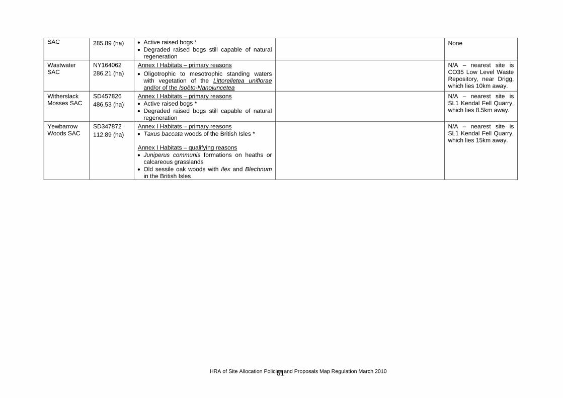
SAC 285.89 (ha) • Active raised bogs * • Degraded raised bogs still capable of natural
regeneration
None
Wastwater SAC
NY164062 286.21 (ha)
Annex I Habitats – primary reasons • Oligotrophic to mesotrophic standing waters
with vegetation of the Littorelletea uniflorae and/or of the Isoëto-Nanojuncetea
N/A – nearest site is CO35 Low Level Waste Repository, near Drigg, which lies 10km away.
Witherslack Mosses SAC
SD457826 486.53 (ha)
Annex I Habitats – primary reasons • Active raised bogs * • Degraded raised bogs still capable of natural
regeneration
N/A – nearest site is SL1 Kendal Fell Quarry, which lies 8.5km away.
Yewbarrow Woods SAC
SD347872 112.89 (ha)
Annex I Habitats – primary reasons • Taxus baccata woods of the British Isles * Annex I Habitats – qualifying reasons • Juniperus communis formations on heaths or
calcareous grasslands • Old sessile oak woods with Ilex and Blechnum
in the British Isles
N/A – nearest site is SL1 Kendal Fell Quarry, which lies 15km away.
HRA of Site Allocation Policies and Proposals Map Regulation March 2010 61

Part 2 – European Sites and Features – SPAs
SITE LOCATION/AREA
REASON(S) FOR DESIGNATION CONSERVATION OBJECTIVES SITE ALLOCATIONS
Duddon Estuary SPA
03 15 24 W 54 10 39 N 6806.3 (ha)
Annex I Species • sandwich tern Sterna sandvicensis (during the
breeding season, supports 1.5% of the GB population - Article 4.1)
• pintail Anas acuta (over winter, supports 2.7% of the population - Article 4.2)
• knot Calidris canuta (over winter, supports 1.3% of the population - Article 4.2)
• redshank Tringa totanus (over winter, supports 0.9% of the population - Article 4.2)
• over winter, the area regularly supports an internationally important assemblage of 31,505 individual water fowl - Article 4.2
In relation to Duddon Estuary SSSI - subject to natural change, to maintain the following habitats and geological features in favourable condition, with particular reference to any dependent component special interest features (habitats, vegetation types, species, species assemblages, etc.) for which the land is designated. Habitat Types represented (Biodiversity Action Plan categories) o Estuary o Saltmarsh o Littoral sediment o Inshore sublittoral sediment o Littoral rock o Inshore sublittoral rock o Coastal vegetated shingle o Sand dune (Strandline, embryo and mobile dunes, Fixed
dune grassland, Humid dune slacks, Dune heath) o Coastal lagoon Species represented o Aggregation of breeding sandwich tern (Annex 1 species) o Breeding bird assemblage o Aggregations of non-breeding birds o Natterjack toad o Invertebrate assemblage o Vascular plant assemblage Geological features (Geological Site Types) Active process geomorphological (IA)
Site CO34 Redhills Quarry, Millom, is a first preference for a Household Waste Recycling Centre and lies 100m from the SPA. Site M31 Salthouse, near Millom, is identified as a potential railhead to be safeguarded for Ghyll Scaur Quarry, and lies 300m from the SPA. Site BA24 Sowerby Woods Business Park, Barrow, is a first preference for a waste treatment facility and lies 800m from the SPA. Site BA10 Goldmire Quarry, Barrow, is a reserve for non-inert landfill and lies 2km from the SPA.
Leighton Moss SPA
02 47 31 W 54 10 03 N 128.61 (ha)
Annex I Species • bittern Botaurus stellaris (during the breeding season,
supports 20% of the GB population - Article 4.1) • marsh harrier Circus aeruginosus (during the
breeding season, supports 1.3% of the GB population - Article 4.1)
N/A – nearest site is SL1 Kendal Fell Quarry, which lies 16.5km away.
Morecambe Bay SPA
02 57 21 W 54 07 19 N 37404.6 (ha)
Annex I Species • sandwich tern Sterna sandvicensis (during the
breeding season, supports 3% of the GB population - Article 4.1)
In relation to South Walney & Piel Channel Flats SSSI - subject to natural change, to maintain the following habitats and geological features in favourable condition, with particular reference to any dependent component special interest features
Site M27 Roose Sand Quarry, Barrow, is a reserve for sand extraction and lies 270m
HRA of Site Allocation Policies and Proposals Map Regulation March 2010 62

SITE LOCATION/AREA
CONSERVATION OBJECTIVES SITE ALLOCATIONS REASON(S) FOR DESIGNATION
• pink-footed goose Anser brachyrhynchus (over winter, supports 1.1% of the world population - Article 4.2)
• pintail Anas acuta (over winter, supports 4.7% of the NW European population - Article 4.2)
• shelduck Tadorna tadorna (over winter, supports 2.1% of the NW European population - Article 4.2)
• knot Calidris canutus (over winter, supports 8.5% of the East Atlantic Flyway population - Article 4.2)
• oystercatcher Haematopus ostralegus (over winter, supports 5.4% of the East Atlantic Flyway population - Article 4.2)
• curlew Numenius arquata (over winter, supports 3.9% of the East Atlantic Flyway population - Article 4.2)
• dunlin Calidris alpina (over winter, supports 3.8% of the East Atlantic Flyway population - Article 4.2)
• redshank Tringa totanus (over winter, supports 3.6% of the East Atlantic Flyway population - Article 4.2)
• bar tailed godwit Limosa lapponica (over winter, supports 2.6% of the East Atlantic Flyway population - Article 4.2)
• turnstone Arenaria interpres (over winter, supports 2.4% of the East Atlantic Flyway population - Article 4.2)
• grey plover Pluvialis squatarola (over winter, supports 1.1% of the East Atlantic Flyway population - Article 4.2)
• ringed plover Charadrius hiaticula (on passage, supports 1.5% of the international population – Article 4.2)
• during the breeding season, the area regularly supports an internationally important assemblage of 61,858 individual seabirds – Article 4.2
• over winter, the area regularly supports an internationally important assemblage of 210,668 individual water fowl - Article 4.2
(habitats, vegetation types, species, species assemblages, etc.) for which the land is designated. Habitat Types represented (Biodiversity Action Plan categories) o Inlets and bays o Littoral sediment o Sublittoral sediment o Littoral rock o Sublittoral rock o Shingle o Saltmarsh o Sand dune (Strandline, embryo and mobile dunes, fixed dune
grassland) o Coastal Lagoon Species represented o Aggregation of breeding birds (sandwich tern (Annex 1
species)) o Aggregations of breeding birds o Aggregations of non-breeding birds o Invertebrate assemblage o Vascular plant assemblage Geological features (Geological Site Types) Active process - geomorphological (IA)
from the SPA.
North Pennine Moors SPA
02 14 49 W 54 39 24 N 147246.41 (ha) cross border with Durham, North Yorks,
Annex I Species merlin Falco columbarius (during the breeding season,
supports 10.5% of the GB population - Article 4.1) golden plover Pluvialis apricaria (during the breeding
season, supports 6.2% of the GB population - Article
In relation to Appleby Fells SSSI – subject to natural change, to maintain the following habitats and geological features in favourable condition, with particular reference to any dependent component special interest features (habitats, vegetation types, species, species assemblages, etc.) for which the land is
Site M18 Stamphill gypsum mine is a first preference for gypsum extraction and lies 3.3km from the SPA.
HRA of Site Allocation Policies and Proposals Map Regulation March 2010 63

SITE LOCATION/AREA
REASON(S) FOR DESIGNATION CONSERVATION OBJECTIVES SITE ALLOCATIONS
Northumbria 4.1) hen harrier Circus cyaneus (during the breeding
season, supports 2.2% of the GB population - Article 4.1)
peregrine Falco peregrinus (during the breeding season, supports 1.3% of the GB population - Article 4.1)
designated. Habitat Types represented (Biodiversity Action Plan categories) o Bogs o Calcareous grassland o Dwarf shrub heath – upland o Montane habitats (montane and boreal heaths) o Fen, Marsh & Swamp o Upland mosaic o Inland Rock (Ledge communities) Species represented o Breeding bird assemblage o Vascular plant assemblage o Gentiana verna o Saxifraga hirculus Geological features (Geological Site Types) o Mines and mine dumps o Inland exposures o Caves and Karst
Site ED10 Crosscroft Industrial Estate, Appleby, is a first preference for a Household Waste Recycling Centre and lies 3.8km from the SPA.
Upper Solway Flats & Marshes SPA
03 25 27 W 54 54 20 N 43636.73 (ha) cross border with Dumfries & Galloway
Annex I Species • barnacle goose Branta leucopsis (over winter,
supports 12.2% of the GB population – Article 4.1) • bar-tailed godwit Limosa lapponica (over winter,
supports 4.5% of the GB population – Article 4.1) • golden plover Pluvialis apricaria (over winter,
supports 2.4% of the GB population – Article 4.1) • whooper swan Cygnus cygnus (over winter, supports
2.1% of the GB population – Article 4.1) • pink-footed goose Anser brachyrhynchus (over
winter, supports 7.1% of the population – Article 4.2) • oystercatcher Haematopus ostralegus (over winter,
supports 4% of the population – Article 4.2) • pintail Anas acuta (over winter, supports 3.8% of the
population – Article 4.2) • knot Calidris canuta (over winter, supports 3.6% of
the population – Article 4.2) • shelduck Tadorna tadorna (over winter, supports 3%
of the GB population – Article 4.2) • dunlin Calidris alpina (over winter, supports 2.7% of
the GB population – Article 4.2)
In relation to Upper Solway Flats & Marshes SSSI - subject to natural change, to maintain the following habitats and geological features in favourable condition, with particular reference to any dependent component special interest features (habitats, vegetation types, species, species assemblages, etc.) for which the land is designated. Habitat Types represented (Biodiversity Action Plan categories) o Estuaries o Inshore sublittoral sediment o Intertidal mudflats and sandflats o Reefs o Saltmarsh including pioneer saltmarsh o Dune grassland o Coastal shingle vegetation o Maritime cliff woodland (in Scotland only) Geological features (Geological Site Types) o Active process geomorphological (IA) Species represented o Aggregations of breeding birds o Aggregations of non-breeding birds
Site CA24 Hespin Wood landfill, near Carlisle, is a first preference for non-inert landfill and also a reserve for a Household Waste Recycling Centre, and lies 740m from the SPA. Site CA31 Kingmoor Park East, Carlisle, is a first preference for a waste treatment facility and also for an Energy from Waste plant, and lies 3.7km from the SPA. Site CA30 Kingmoor Road recycling centre, Carlisle, is a first
HRA of Site Allocation Policies and Proposals Map Regulation March 2010 64

SITE LOCATION/AREA
SITE ALLOCATIONS REASON(S) FOR DESIGNATION CONSERVATION OBJECTIVES
• grey plover Pluvialis squatarola (over winter, supports 2.4% of the GB population – Article 4.2)
• curlew Numenius arquata (over winter, supports 1.7% of the population – Article 4.2)
• redshank Tringa totanus (over winter, supports 1.7% of the GB population – Article 4.2)
• goldeneye Bucephala clangula (over winter, supports 1.1% of the GB population – Article 4.2)
• teal Anas crecca (over winter, supports 0.9% of the GB population – Article 4.2)
• turnstone Arenaria interpres (over winter, supports 0.9% of the GB population – Article 4.2)
• sanderling Calidris alba (over winter, supports 0.9% of the GB population – Article 4.2)
• shoveler Anas clypeata (over winter, supports 0.5% of the GB population – Article 4.2)
• scaup Aythya marila (over winter, supports 0.5% of the population – Article 4.2)
• over winter, the area regularly supports an internationally important assemblage of 133,440 individual water fowl - Article 4.2
o Assemblage of non-breeding birds o Breeding bird assemblage o Natterjack Toad o Great crested newt o Vascular Plant assemblage o Invertebrate assemblage
preference for a waste treatment facility and lies 5km from the SPA. Site CA28 Rockcliffe Estate, Kingmoor Park, is a reserve for a waste treatment facility and lies 1.3km from the SPA. Site CA29 Heathlands Estate, Kingmoor Park, is a reserve for a waste treatment facility and also for an Energy from Waste plant, and lies 2.3km from the SPA.
HRA of Site Allocation Policies and Proposals Map Regulation March 2010 65

Part 3 – European Sites and Features – RAMSAR
SITE LOCATION/ AREA
REASON(S) FOR DESIGNATION CONSERVATION OBJECTIVES SITE ALLOCATIONS
Duddon Estuary Ramsar
03 15 24 W 54 10 39 N 6806.3 (ha)
Criterion 2 supports nationally important numbers of the rare natterjack toad Bufo calamita, near the northwestern edge of its range (an estimated 18-24% of the British population). Supports a rich assemblage of wetland plants and invertebrates - at least one nationally scarce plant and at least two British Red Data Book invertebrates. Criterion 4 supports nationally important numbers of waterfowl during spring and autumn passage Criterion 5 over winter, supports an internationally important assemblage of 26,326 waterfowl Criterion 6 over winter, supports internationally important populations of northern pintail, red knot and common redshank
In relation to Duddon Estuary SSSI - subject to natural change, to maintain the following habitats and geological features in favourable condition, with particular reference to any dependent component special interest features (habitats, vegetation types, species, species assemblages, etc.) for which the land is designated. Habitat Types represented (Biodiversity Action Plan categories) o Estuary o Saltmarsh o Littoral sediment o Inshore sublittoral sediment o Littoral rock o Inshore sublittoral rock o Coastal vegetated shingle o Sand dune (Strandline, embryo and mobile dunes,
Fixed dune grassland, Humid dune slacks, Dune heath) o Coastal lagoon Species represented o Aggregation of breeding sandwich tern (Annex 1
species) o Breeding bird assemblage o Aggregations of non-breeding birds o Natterjack toad o Invertebrate assemblage o Vascular plant assemblage Geological features (Geological Site Types) o Active process geomorphological (IA)
Site CO34 Redhills Quarry, Millom, is a first preference for a Household Waste Recycling Centre and lies 100m from the Ramsar. Site M31 Salthouse, near Millom, is identified as a potential railhead to be safeguarded for Ghyll Scaur Quarry, and lies 300m from the Ramsar. Site BA24 Sowerby Woods Business Park, Barrow, is a first preference for a waste treatment facility and lies 800m from the Ramsar. Site BA10 Goldmire Quarry, Barrow, is a reserve for non-inert landfill and lies 2km from the Ramsar.
Esthwaite Water Ramsar
02 59 06 W 54 21 37 N 137.4 (ha)
Criterion 1 a particularly good example of a mesotrophic lake, with a well developed hydrosere at the northern end Criterion 2 supports a rich assemblage of pondweed species and is the only known locality in England and Wales for slender naiad Najas flexilis. The diverse aquatic invertebrate fauna includes a number of
N/A – nearest site is SL1 Kendal Fell Quarry, which lies 13.5km away.
HRA of Site Allocation Policies and Proposals Map Regulation March 2010 66

SITE LOCATION/ AREA
REASON(S) FOR DESIGNATION CONSERVATION OBJECTIVES SITE ALLOCATIONS
species with restricted distributions in Britain. Irthinghead Mires Ramsar
02 30 43 W 55 04 46 N 792.08 (ha) cross border with Northumbria
Criterion 1 supports an outstanding example of undamaged blanket bogs, characteristic of the vegetation of upland north-western Britain. Most English blanket bogs have been extensively degraded by afforestation, burning, agricultural drainage and overgrazing. The Irthinghead Mires are one of few examples of this vegetation type in a near-natural state. There is also good representation of different topographic mire type and surface patterning. Criterion 2 notable variety of Sphagnum mosses Criterion 3 Butterburn Flow has several rare plants, whilst a rare spider, Eboria caliginosa, has been recorded at Coom Rogg Moss
None.
Leighton Moss Ramsar
02 47 31 W 54 10 03 N 128.61 (ha) cross border with Lancashire
Criterion 1 reedbeds, of particular importance as a northern outpost for breeding populations of great bittern Botaurus stellaris, Eurasian marsh harrier Circus aeruginosus and bearded tit Panurus biarmicus. Criterion 3 as well as supporting a range of breeding birds, also supports species occurring in nationally important numbers outside the breeding season, including northern shoveler Anas clypeata and water rail Rallus aquaticus
N/A – nearest site is SL1 Kendal Fell Quarry, which lies 16.5km away.
Morecambe Bay Ramsar
02 57 21 W 54 07 19 N 37404.6 (ha) cross border with Lancashire
Criterion 4 staging area for migratory waterfowl including internationally important numbers of passage ringed plover Charadrius hiaticula. Criterion 5 over winter, supports an internationally important assemblage of 223,709 waterfowl Criterion 6 wide range species/populations occurring at levels of international importance
In relation to South Walney & Piel Channel Flats SSSI - subject to natural change, to maintain the following habitats and geological features in favourable condition, with particular reference to any dependent component special interest features (habitats, vegetation types, species, species assemblages, etc.) for which the land is designated. Habitat Types represented (Biodiversity Action Plan categories) o Inlets and bays o Littoral sediment o Sublittoral sediment o Littoral rock o Sublittoral rock
Site M27 Roose Sand Quarry, Barrow, is a reserve for sand extraction and lies 270m from the Ramsar.
HRA of Site Allocation Policies and Proposals Map Regulation March 2010 67

SITE LOCATION/ AREA
REASON(S) FOR DESIGNATION ON OBJECTIVES SITE ALLOCATIONS CONSERVATI
o Shingle o Saltmarsh o Sand dune (Strandline, embryo and mobile dunes, fixed
dune grassland) o Coastal Lagoon Species represented o Aggregation of breeding birds (sandwich tern (Annex 1
species)) o Aggregations of breeding birds o Aggregations of non-breeding birds o Invertebrate assemblage o Vascular plant assemblage Geological features (Geological Site Types) • Active process - geomorphological (IA)
Upper Solway Flats & Marshes Ramsar
03 25 27 W 54 54 20 N 43636.73 (ha)
Criterion 2 supports over 10% of the British population of natterjack toad Bufo calamita Criterion 5 over winter, supports an internationally important assemblage of 135,720 waterfowl Criterion 6 wide range species/populations occurring at levels of international importance
In relation to Upper Solway Flats & Marshes SSSI - subject to natural change, to maintain the following habitats and geological features in favourable condition, with particular reference to any dependent component special interest features (habitats, vegetation types, species, species assemblages, etc.) for which the land is designated. Habitat Types represented (Biodiversity Action Plan categories) o Estuaries o Inshore sublittoral sediment o Intertidal mudflats and sandflats o Reefs o Saltmarsh including pioneer saltmarsh o Dune grassland o Coastal shingle vegetation o Maritime cliff woodland (in Scotland only) Geological features (Geological Site Types) o Active process geomorphological (IA) Species represented o Aggregations of breeding birds o Aggregations of non-breeding birds o Assemblage of non-breeding birds o Breeding bird assemblage o Natterjack Toad o Great crested newt o Vascular Plant assemblage o Invertebrate assemblage
Site CA24 Hespin Wood landfill, near Carlisle, is a first preference for non-inert landfill and also a reserve for a Household Waste Recycling Centre, and lies 740m from the Ramsar. Site CA31 Kingmoor Park East, Carlisle, is a first preference for a waste treatment facility and also for an Energy from Waste plant, and lies 3.7km from the Ramsar. Site CA30 Kingmoor Road recycling centre, Carlisle, is a first preference for a waste treatment facility and lies 5km from the Ramsar.
HRA of Site Allocation Policies and Proposals Map Regulation March 2010 68

HRA of Site Allocation Policies and Proposals Map Regulation March 2010 70
Part 4 – European Sites and Features – adjoining authorities
SITE PRIMARY FEATURES
Craven Limestone Complex SAC Active raised bogs, alkaline fens Petrifying springs Limestone pavements Molinia meadows, semi-natural dry grasslands and scrubland Hard oligo-mesotrphic waters with benthic vegetation
Ingleborough Complex SAC Large stands of Juniper Alkaline fens Calcareous rocky slopes Limestone pavements
Ox Close SAC Calaminarian grasslands Roman Wall Loughs SAC Natural eutrophic lakes, pondweeds Tyne and Allen River Gravels SAC Calaminarian grasslands

MAPS OF EUROPEAN WILDLIFE SITES AND LOCATIONS OF PROPOSED SITES
HRA of Site Allocation Policies and Proposals Map Regulation March 2010 71

HRA of Site Allocation Policies and Proposals Map Regulation March 2010 72

HRA of Site Allocation Policies and Proposals Map Regulation March 2010 74

HRA of Site Allocation Policies and Proposals Map Regulation March 2010 75

HRA of Site Allocation Policies and Proposals Map Regulation March 2010 76

HRA of Site Allocation Policies and Proposals Map Regulation March 2010 77

HRA of Site Allocation Policies and Proposals Map Regulation March 2010 80

HRA of Site Allocation Policies and Proposals Map Regulation March 2010 81

HRA of Site Allocation Policies and Proposals Map Regulation March 2010 82

HRA of Site Allocation Policies and Proposals Map Regulation March 2010 84

HRA of Site Allocation Policies and Proposals Map Regulation March 2010 86

HRA of Site Allocation Policies and Proposals Map Regulation March 2010 87

HRA of Site Allocation Policies and Proposals Map Regulation March 2010 89

HRA of Site Allocation Policies and Proposals Map Regulation March 2010 90

HRA of Site Allocation Policies and Proposals Map Regulation March 2010 92