san francisco best practices
TRANSCRIPT

Ali Emad Jehad – P71084
Mohanad Jaafar Talib - P71085
Haitham Thamer Ismael - P71057

Introduction The only consolidated city-county in California, San Francisco
encompasses a land area of about 46.9 square miles (121 km2) on the northern end of the San Francisco Peninsula, giving it a density of about 17,620 people per square mile (6,803 people per km2). It is the most densely settled large city (population greater than 200,000) in the state of California and the second-most densely populated major city in the United States after New York.
Today, San Francisco is ranked 35th of the top tourist destinations in the world,[19] and was the sixth most visited one in the United States in 2011.[20] The city is renowned for its cool summers, fog, steep rolling hills, eclectic mix of architecture, and landmarks including the Golden Gate Bridge, cable cars, the former prison on Alcatraz Island, and its Chinatown district. It is also a primary banking and finance center.

San Francisco (Evening)
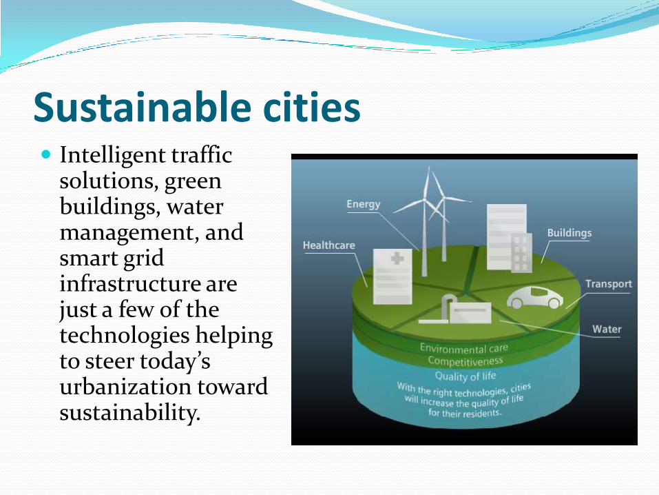
Sustainable cities Intelligent traffic
solutions, green buildings, water management, and smart grid infrastructure are just a few of the technologies helping to steer today’s urbanization toward sustainability.

Transportation
Due to its unique geography, and the freeway revolts of the late 1950s, San Francisco is one of the few American cities with arterial thoroughfares instead of having numerous highways within the city.
Interstate 80 begins at the approach to the Bay Bridge and is the only direct automobile link to the East Bay. U.S. Route 101 connects to the western terminus of Interstate 80 and provides access to the south of the city along San Francisco Bay toward Silicon Valley. Northbound, the routing for U.S. 101 uses arterial streets Mission Street, Van Ness Avenue, Lombard Street, Richardson Avenue, and Doyle Drive to connect to the Golden Gate Bridge, the only direct automobile link to Marin County and the North Bay.
Public transportation
32% of San Francisco residents use public transportation in daily commuting to work, ranking it first on the West Coast and third overall in the United States. The San Francisco Municipal Railway, known as Muni, is the primary public transit system of San Francisco. Muni is the seventh largest transit system in the United States, with 210,848,310 rides in 2006. The system operates both a combined light rail and subway system, the Muni Metro, and a large bus network. Additionally, it runs a historic streetcar line, which runs on Market Street from Castro Street to Fisherman's Wharf.

Cable CarsIt also operates the famous cablecars, which have been designatedas a National Historic Landmarkand are a major touristattraction.As of August 23, 2013, riding acable car costs $6 for a singleride, except for seniors ridingbefore 7am or after 9pm whenthe senior fare is $3

Mass transit The Bay Area is served by a number of mass transit
systems: Bay Area Rapid Transit (BART) - A subway/commuter rail
service that serves parts of the Bay Area, including San Francisco, Oakland, Berkeley, Fremont, and Walnut Creek.
Caltrain - A commuter rail service that connects San Jose and cities along the Peninsula with San Francisco, and with the BART system by way of the Millbrae Station.
Amtrak - There are several Amtrak stations throughout the Bay Area. Major stations in Martinez and Emeryville feature Coast Starlight and California Zephyr service.
ACE - Altamont Commuter Express; a rail service that mainly serves commuters to and from the Central Valley to the Silicon Valley.

Mass Transit Systems:

Bay Area Rapid Transit (BART) (BART) is a rapid transit system serving the San Francisco
Bay Area. The heavy-rail public transit and subway system connects San Francisco with cities in the East Bay and suburbs in northern San Mateo County.

BART operates fiveroutes on 104 miles(167 km) of line,with 44 stations infour counties.With an average of373,945 weekdaypassengers, 176,616Saturdaypassengers, and119,247 Sundaypassengers inJanuary 2013,[3]BART is the fifth-busiest heavy railrapid transitsystem in theUnited States. BART Map Day

San Francisco Bay Ferry The San Francisco Bay Ferry (SFBF) is a passenger ferry
service on San Francisco Bay, owned by the San Francisco Bay Area Water Emergency Transportation Authority (WETA) and operated by Blue & Gold Fleet.
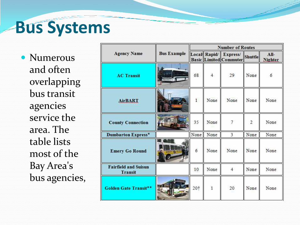
Bus Systems
Numerous and often overlapping bus transit agencies service the area. The table lists most of the Bay Area's bus agencies,


Walking & Cycling Cycling is a popular mode of transportation in San
Francisco. 75,000 residents commute by bicycle per day.
Pedestrian traffic is a major mode of transport. In 2011, Walk Score ranked San Francisco the second most walkablecity in the United States.
The San Francisco Municipal Transportation Agency and Bay Area Air Quality Management District are responsible for the operation with management provided by Alta Bicycle Share. The system will be expanded in the future.

SAN FRANCISCO TRANSPORTATION PLAN (SFTP)


WHAT'S NEXT? Every four years, the Transportation Authority Board
adopts a Prop K Strategic Plan to guide how and when to invest local transportation half-cent sales tax funds.