sample - region 4 education service center - sample.pdf · region 4 education service center. ......
TRANSCRIPT

SAMPLE

5 Es over Texas Social Studies STAAR® Preparation Grade 7© Region 4 Education Service Center. All rights reserved.
Reporting Category 1 39Lesson 1: Eras in Texas History 39Lesson 2: American Indian Cultures 43Lesson 3: European Exploration and Colonization 49Lesson 4: Religious Establishments 55Lesson 5: Mexican Independence 59Lesson 6: Significant Individuals 63Lesson 7: Texas Settlements 67Lesson 8: Texas Revolution 69Lesson 9: Texas Revolution: Cause and Effects 73Lesson 10: Republic of Texas 77Lesson 11: Texas Annexation 81Lesson 12: The Civil War 85Lesson 13: Westward Expansion 89Lesson 14: Reconstruction through Beginning of 20th Century 93Lesson 15: Industry 97Lesson 16: Reform Movements 101Lesson 17: The Great Depression 105Lesson 18: World Wars 109
Table of Contents
Introduction 1Overview 1National Council for the Social Studies Standards 3Curriculum, Instruction, and Assessment Framework 6Curriculum Overview 7Correlation between Texas and U.S. History Courses 8Instruction: Components of an Effective Lesson 17Instruction: 5 Es over Texas Lesson FAQs 19Instruction: Highly Effective Instructional Strategies 20Instruction: Lesson Vertical Alignment Chart 23Assessment: Overview 25Assessment: Selected Response 26Assessment: Performance Assessment 27Assessment: Instructional Rubric 28References and Bibliography 30Grade 7 Social Studies TEKS 32
SAMPLE

5 Es over Texas Social Studies STAAR® Preparation Grade 7© Region 4 Education Service Center. All rights reserved.
Reporting Category 2 113Lesson 19: Mapping Texas 113Lesson 20: The Galveston Storm and the Dust Bowl 117Lesson 21: Immigrants and Immigration 121Lesson 22: Demographics 125Lesson 23: Cultural Diversity 129
Reporting Category 3 133Lesson 24: The Texas Constitution 133Lesson 25: Structure and Function of Government 137Lesson 26: Citizenship 141Lesson 27: Texas Leaders 145Lesson 28: The Two-Party System 149
Reporting Category 4 153Lesson 29: Urbanization 153Lesson 30: Globalization and Free Enterprise 157Lesson 31: Technology and Scientists 161Lesson 32: Effects of Innovation 165
SAMPLE
5 Es over Texas Social Studies STAAR® Preparation Grade 7© Region 4 Education Service Center. All rights reserved.
15
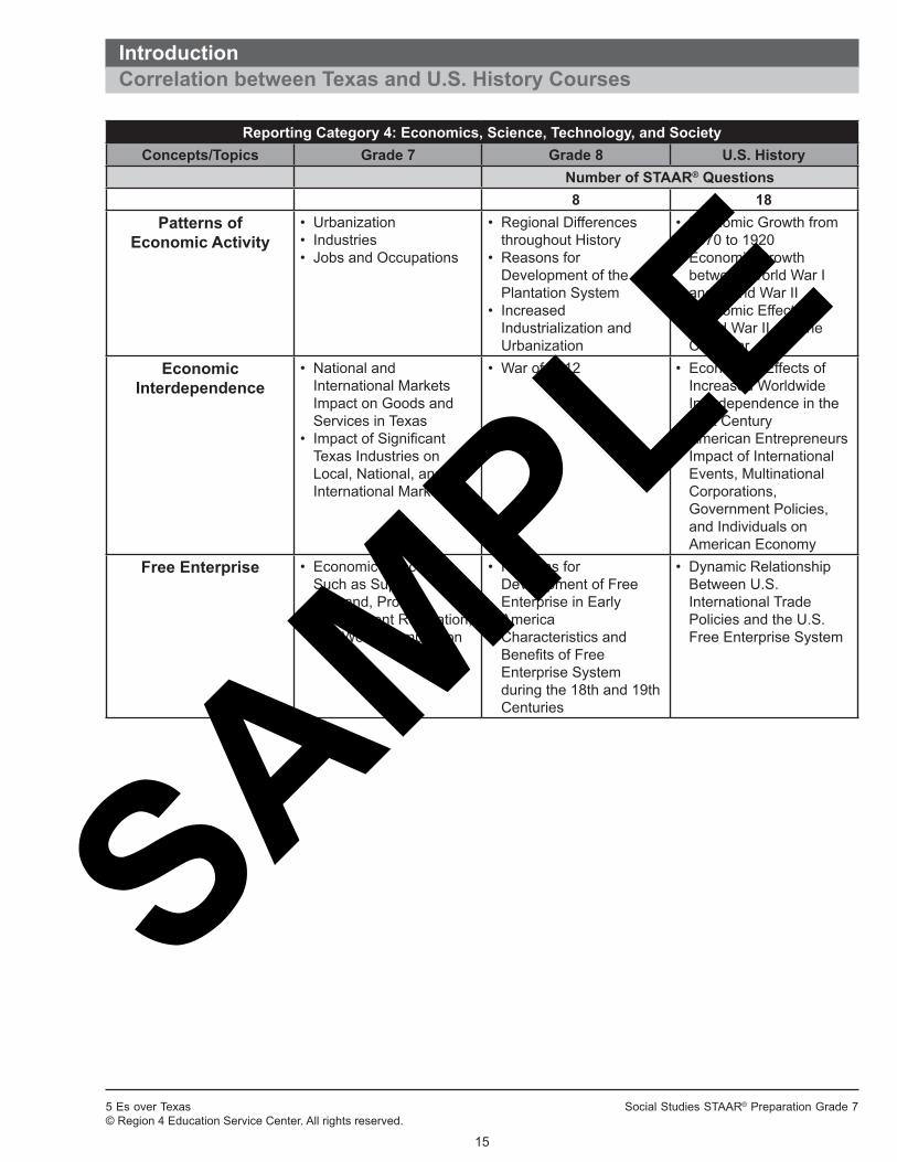
IntroductionCorrelation between Texas and U.S. History Courses
Reporting Category 4: Economics, Science, Technology, and SocietyConcepts/Topics Grade 7 Grade 8 U.S. History
Number of STAAR® Questions8 18
Patterns ofEconomic Activity
• Urbanization• Industries• Jobs and Occupations
• Regional Differences throughout History
• Reasons for Development of the Plantation System
• Increased Industrialization and Urbanization
• Economic Growth from 1870 to 1920
• Economic Growth between World War I and World War II
• Economic Effects of World War II and the Cold War
Economic Interdependence
• National and International Markets Impact on Goods and Services in Texas
• Impact of Significant Texas Industries on Local, National, and International Markets
• War of 1812 • Economics Effects of Increased Worldwide Interdependence in the 21st Century
• American Entrepreneurs• Impact of International
Events, Multinational Corporations, Government Policies, and Individuals on American Economy
Free Enterprise • Economic Concepts Such as Supply, Demand, Profit, Government Regulation, and World Competition
• Reasons for Development of Free Enterprise in Early America
• Characteristics and Benefits of Free Enterprise System during the 18th and 19th Centuries
• Dynamic Relationship Between U.S. International Trade Policies and the U.S. Free Enterprise System
SAMPLE

5 Es over Texas Social Studies STAAR® Preparation Grade 7© Region 4 Education Service Center. All rights reserved.
23
Intr
oduc
tion
Inst
ruct
ion:
Les
son
Vert
ical
Alig
nmen
t Cha
rt
Bel
ow is
a v
ertic
al a
lignm
ent o
f the
STA
AR
® R
epor
ting
Cat
egor
ies
and
the
5Es
over
Tex
as le
sson
s. E
ach
less
on w
ill in
clud
e m
ultip
le T
EK
S. A
lthou
gh e
ach
less
on a
ddre
sses
var
ious
sec
tions
of S
TAA
R®, o
ne o
f the
four
repo
rting
cat
egor
ies
is a
maj
or fo
cus
and
the
less
on h
as b
een
plac
ed u
nder
that
cat
egor
y in
this
boo
k. H
owev
er, m
ultip
le p
iece
s of
the
stat
e cu
rric
ulum
are
bei
ng
taug
ht a
nd a
sses
sed
sim
ulta
neou
sly,
and
the
soci
al s
tudi
es s
kills
are
em
bedd
ed th
roug
hout
the
less
ons.
Eac
h le
sson
end
s w
ith
se
lect
ed-r
espo
nse
ques
tions
, for
mat
ted
to re
sem
ble
STA
AR
®, a
s w
ell a
s a
perfo
rman
ce a
sses
smen
t tas
k.
Rep
ortin
g C
ateg
ory
1: H
isto
ryLe
sson
7th
Gra
de T
EKS
8th
Gra
de T
EKS
U.S
. His
tory
TEK
S1.
01 E
ras
in T
exas
His
tory
1A, 1
B, 1
C1A
, 1B
, 1C
, 9A
, 9C
2A, 2
C, 2
D, 7
A, 7
B, 7
D, 7
E1.
02 A
mer
ican
Indi
an C
ultu
res
2A1.
03 E
urop
ean
Exp
lora
tion
and
Col
oniz
atio
n2B
2A1.
04 R
elig
ious
Est
ablis
hmen
ts2C
, 21A
29A
1.05
Mex
ican
Inde
pend
ence
2D12
B1.
06 S
igni
fican
t Ind
ivid
uals
2E1.
07 T
exas
Set
tlem
ents
2F1.
08 T
exas
Rev
olut
ion
2D, 3
A, 3
C1.
09 T
exas
Rev
olut
ion:
Cau
se a
nd E
ffect
s3B
, 3C
, 21B
29B
29B
1.10
Rep
ublic
of T
exas
3D, 4
A1.
11 T
exas
Ann
exat
ion
4B, 4
C6D
4A, 1
2B1.
12 T
he C
ivil
War
5A, 5
B, 5
C1A
, 1C
, 7C
, 8B
, 12B
, 17B
1.13
Wes
twar
d E
xpan
sion
6A5G
, 6B
, 6E
, 9C
, 27D
1.14
Rec
onst
ruct
ion
thro
ugh
Beg
inni
ng o
f 20t
h C
entu
ry6B
, 6C
, 6D
9C1.
15 In
dust
ry7A
, 7B
, 1C
3A, 3
B, 1
1B
1.16
Ref
orm
Mov
emen
ts7C
, 7D
, 21B
3C, 5
A, 5
B, 5
C, 9
B, 9
C, 9
D,
9E, 9
F, 9
G, 9
H, 9
I, 11
B, 1
7A,
23A
, 26A
1.17
The
Gre
at D
epre
ssio
n7E
4C, 7
B, 1
6D, 1
6E, 1
7A, 1
7B,
19B
1.18
Wor
ld W
ars
7E, 2
1C, 2
1D8A
, 11B
, 2D
, 7B
, 7G
, 15D
, 17A
, 19
B
SAMPLE

5 Es over Texas Social Studies STAAR® Preparation Grade 7© Region 4 Education Service Center. All rights reserved.
113
Reporting Category 2 Lesson 19: Mapping Texas
Reporting Category: 2 The student will demonstrate an understanding of geographic and cultural influences on historical issues and events.
TEKS Objectives: 8A Create and interpret thematic maps, graphs, charts, models, and databases representing various aspects of Texas during the 19th, 20th, and 21st centuries
9A Locate the Mountains and Basins, Great Plains, North Central Plains, and Coastal Plains regions and places of importance in Texas during the 19th, 20th, and 21st centuries such as major cities, rivers, natural and historic landmarks, political and cultural regions, and local points of interest
9B Compare places and regions of Texas in terms of physical and human characteristics
MaterialsFor each student
• RM 83: Mapping Texas • Texas atlases and/or maps• Textbooks or other resources containing information about Texas’ four geographic regions• RM 84: Texas Region Brochure Rubric • RM 85: Lesson 19 Evaluate
For student groups • RM 82: Texas Locations Matching Cards
Advance Preparation• Duplicate and cut out RM 82 for each group of three students.• Optional: Arrange for computer access for use during Explore, Explain, and Elaborate.
© REGION 4 EDUCATION SERVICE CENTER. ALL RIGHTS RESERVED.5Es OVER TEXAS SOCIAL STUDIES STAAR® PREPARATION, GRADE 7
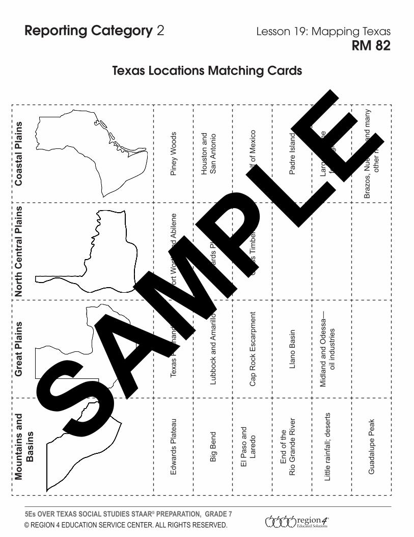
Reporting Category 2 Lesson 19: Mapping TexasRM 82
Texas Locations Matching Cards
Mou
ntai
ns a
nd
Bas
ins
Gre
at P
lain
sN
orth
Cen
tral
Pla
ins
Coa
stal
Pla
ins
Edw
ards
Pla
teau
Texa
s P
anha
ndle
Fort
Wor
th a
nd A
bile
neP
iney
Woo
ds
Big
Ben
dLu
bboc
k an
d A
mar
illo
Edw
ards
Pla
teau
Hou
ston
and
San
Ant
onio
El P
aso
and
Lare
doC
ap R
ock
Esc
arpm
ent
Cro
ss T
imbe
rsG
ulf o
f Mex
ico
End
of t
he
Rio
Gra
nde
Riv
erLl
ano
Bas
inP
adre
Isla
nd
Littl
e ra
infa
ll; d
eser
tsM
idla
nd a
nd O
dess
a—oi
l ind
ustri
esLa
rges
t of t
hefo
ur re
gion
s
Gua
dalu
pe P
eak
Bra
zos,
Nue
ces,
and
man
y ot
her r
iver
s
© REGION 4 EDUCATION SERVICE CENTER. ALL RIGHTS RESERVED.5Es OVER TEXAS SOCIAL STUDIES STAAR® PREPARATION, GRADE 7
Reporting Category 2 Lesson 19: Mapping TexasRM 83
Mapping Texas
Regions of Texas Physical Features and Locations Cities
Great Plains
Coastal Plains
Mountains and Basins
North Central Plains
Big Bend
Brazos River
Cap Rock Escarpment
Edwards Plateau
Guadalupe Peak
Gulf of Mexico
Llano Basin
Neches River
Nueces River
Padre Island
Permian Basin
Piney Woods
Red River
Rio Grande River
Sabine River
Texas Panhandle
Abilene
Amarillo
Fort Worth
Houston
Laredo
Lubbock
Midland
Odessa
San Antonio
Use available resources to locate these places and label them on the map.
Page 1 of 2© REGION 4 EDUCATION SERVICE CENTER. ALL RIGHTS RESERVED.5Es OVER TEXAS SOCIAL STUDIES STAAR® PREPARATION, GRADE 7
Reporting Category 2 Lesson 19: Mapping TexasRM 84
Texas Region Brochure Rubric
CATEGORY Excellent Very Good Good Needs More Work
Content Accuracy
All facts in the brochure are accurate.
99–90% of the facts in the brochure are accurate.
89–80% of the facts in the brochure are accurate.
Fewer than 80% of the facts in the brochure are accurate.
Graphics/Pictures
Graphics go well with the text, and there is a good mix of text and graphics.
Graphics go well with the text, but there are so many that they distract from the text.
Graphics go well with the text, but there are too few and the brochure seems text-heavy.
Graphics do not go with the accompanying text or appear to be randomly chosen.
Writing/ Mechanics
Capitalization and punctuation are correct throughout the brochure.
Capitalization and punctuation are correct throughout the brochure after feedback from an adult.
There are 1–2 capitalization and/or punctuation errors in the brochure even after feedback from an adult.
There are several capitalization or punctuation errors in the brochure even after feedback from an adult.
© REGION 4 EDUCATION SERVICE CENTER. ALL RIGHTS RESERVED.5Es OVER TEXAS SOCIAL STUDIES STAAR® PREPARATION, GRADE 7
Reporting Category 2 Lesson 19: Mapping Texas
1 The best title for the list above would be —
A Mountains and Basins
B Great Plains
C North Central Plains
D Coastal Plains
2 Which of the following regions would be best for a lumber industry?
A Mountains and Basins
B Great Plains
C North Central Plains
D Coastal Plains
Page 1 of 3
RM 85
Lesson 19 Evaluate
• El Paso• Big Bend• Rio Grande River• Edwards Plateau
SAMPLE
5 Es over Texas Social Studies STAAR® Preparation Grade 7© Region 4 Education Service Center. All rights reserved.
114
Reporting Category 2 Lesson 19: Mapping Texas
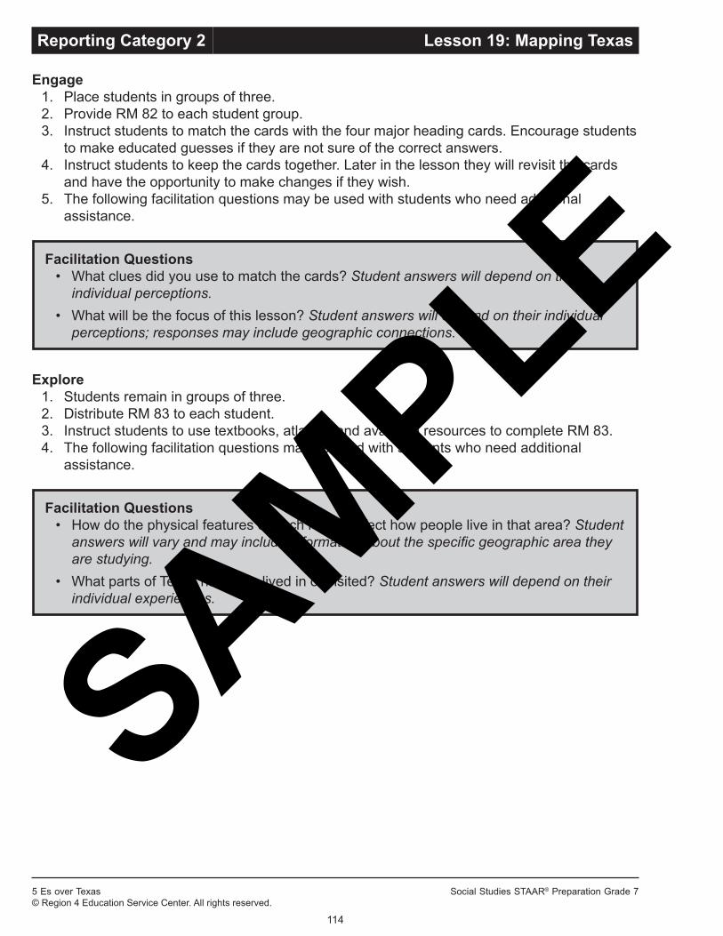
Engage 1. Place students in groups of three.2. Provide RM 82 to each student group.3. Instruct students to match the cards with the four major heading cards. Encourage students
to make educated guesses if they are not sure of the correct answers.4. Instruct students to keep the cards together. Later in the lesson they will revisit the cards
and have the opportunity to make changes if they wish.5. The following facilitation questions may be used with students who need additional
assistance.
Facilitation Questions• What clues did you use to match the cards? Student answers will depend on their
individual perceptions.• What will be the focus of this lesson? Student answers will depend on their individual
perceptions; responses may include geographic connections.
Explore 1. Students remain in groups of three.2. Distribute RM 83 to each student.3. Instruct students to use textbooks, atlases, and available resources to complete RM 83.4. The following facilitation questions may be used with students who need additional
assistance.
Facilitation Questions• How do the physical features of each region affect how people live in that area? Student
answers will vary and may include information about the specific geographic area they are studying.
• What parts of Texas have you lived in or visited? Student answers will depend on their individual experiences.
SAMPLE

5 Es over Texas Social Studies STAAR® Preparation Grade 7© Region 4 Education Service Center. All rights reserved.
115
Reporting Category 2 Lesson 19: Mapping Texas
Explain1. Students may work individually or in pairs.2. Instruct students to use available resources to find information that describes the four
geographic regions of Texas.3. Instruct students to read the text and create a note-taking guide while reading. A sample
note-taking guide is shown below. The structure of the text affects what form the note-taking guide takes.
Categories Mountainsand Basins Great Plains North Central
Plains Coastal Plains
Physical featuresMajor cities and townsIndustriesEntertainment and recreation
4. Instruct students to return to the groups created during Engage and review RM 82.5. Instruct students to make any desired changes based on what they have just read.
Possible answers for RM 82:
Categories Mountainsand Basins Great Plains North Central
Plains Coastal Plains
Physical features Guadalupe PeakDavis Mountains
Llano BasinEdwards PlateauHigh PlainsCap Rock Escarpment
Grand PrairieCross TimbersRolling PlainsBalcones Escarpment
Piney WoodsPost Oak BeltBlackland PrairieGulf Coastal PlainSouth Texas Plain
Major cities and towns
El PasoOdessa
Fort Worth MidlandAbileneWichita Falls
AmarilloLubbock
HoustonDallas*AustinSan AntonioBrownsville
Industries Cattle ranchingAgriculturePetroleumCattle ranching
Cattle ranchingAgriculture
FishingShippingAerospaceAgricultureLumberTourism
Entertainment and recreation
CampingWildlife preservesBig Bend National Park
Garner State ParkBig Springs StatePark
Water sportsJohnson Space Center
Reliant StadiumMinute Maid Park
*Dallas is located in both the North Central Plains and Coastal Plains.6. The following facilitation questions may be used with students who need additional
assistance.
SAMPLE

5 Es over Texas Social Studies STAAR® Preparation Grade 7© Region 4 Education Service Center. All rights reserved.
116
Reporting Category 2 Lesson 19: Mapping Texas
Facilitation Questions• What effects of the physical geography on human activity can you identify? Students
should make connections between the physical geography and human activities, such as lakes and rivers as places where people participate in water sports.
• Where in Texas would you most like to live? Why? Students should make connections to places in the state where the physical geography supports their favorite activities.
Elaborate1. Instruct students to work individually and select one of the four regions of Texas for which to
create a brochure that illustrates and describes that region.2. Provide RM 84 to each student to follow as they create their brochures. Brochures can be
made using paper or computers.
Evaluate1. Instruct students to complete the RM 85 assessment.
RM 85 Answer Key1. A2. D3. D4. A
SAMPLE
© REGION 4 EDUCATION SERVICE CENTER. ALL RIGHTS RESERVED.5Es OVER TEXAS SOCIAL STUDIES STAAR® PREPARATION, GRADE 7
Reporting Category 2 Lesson 19: Mapping TexasRM 82
Texas Locations Matching Cards
Mou
ntai
ns a
nd
Bas
ins
Gre
at P
lain
sN
orth
Cen
tral
Pla
ins
Coa
stal
Pla
ins
Edw
ards
Pla
teau
Texa
s P
anha
ndle
Fort
Wor
th a
nd A
bile
neP
iney
Woo
ds
Big
Ben
dLu
bboc
k an
d A
mar
illo
Edw
ards
Pla
teau
Hou
ston
and
San
Ant
onio
El P
aso
and
Lare
doC
ap R
ock
Esc
arpm
ent
Cro
ss T
imbe
rsG
ulf o
f Mex
ico
End
of t
he
Rio
Gra
nde
Riv
erLl
ano
Bas
inP
adre
Isla
nd
Littl
e ra
infa
ll; d
eser
tsM
idla
nd a
nd O
dess
a—oi
l ind
ustri
esLa
rges
t of t
hefo
ur re
gion
s
Gua
dalu
pe P
eak
Bra
zos,
Nue
ces,
and
man
y ot
her r
iver
s
SAMPLE

© REGION 4 EDUCATION SERVICE CENTER. ALL RIGHTS RESERVED.5Es OVER TEXAS SOCIAL STUDIES STAAR® PREPARATION, GRADE 7
Reporting Category 2 Lesson 19: Mapping TexasRM 83
Mapping Texas
Regions of Texas Physical Features and Locations Cities
Great Plains
Coastal Plains
Mountains and Basins
North Central Plains
Big Bend
Brazos River
Cap Rock Escarpment
Edwards Plateau
Guadalupe Peak
Gulf of Mexico
Llano Basin
Neches River
Nueces River
Padre Island
Permian Basin
Piney Woods
Red River
Rio Grande River
Sabine River
Texas Panhandle
Abilene
Amarillo
Fort Worth
Houston
Laredo
Lubbock
Midland
Odessa
San Antonio
Use available resources to locate these places and label them on the map.
Page 1 of 2
SAMPLE

© REGION 4 EDUCATION SERVICE CENTER. ALL RIGHTS RESERVED.5Es OVER TEXAS SOCIAL STUDIES STAAR® PREPARATION, GRADE 7
Reporting Category 2 Lesson 19: Mapping Texas
Page 2 of 2
RM 83 continued
SAMPLE

© REGION 4 EDUCATION SERVICE CENTER. ALL RIGHTS RESERVED.5Es OVER TEXAS SOCIAL STUDIES STAAR® PREPARATION, GRADE 7
Reporting Category 2 Lesson 19: Mapping TexasRM 84
Texas Region Brochure Rubric
CATEGORY Excellent Very Good Good Needs More Work
Content Accuracy
All facts in the brochure are accurate.
99–90% of the facts in the brochure are accurate.
89–80% of the facts in the brochure are accurate.
Fewer than 80% of the facts in the brochure are accurate.
Graphics/Pictures
Graphics go well with the text, and there is a good mix of text and graphics.
Graphics go well with the text, but there are so many that they distract from the text.
Graphics go well with the text, but there are too few and the brochure seems text-heavy.
Graphics do not go with the accompanying text or appear to be randomly chosen.
Writing/ Mechanics
Capitalization and punctuation are correct throughout the brochure.
Capitalization and punctuation are correct throughout the brochure after feedback from an adult.
There are 1–2 capitalization and/or punctuation errors in the brochure even after feedback from an adult.
There are several capitalization or punctuation errors in the brochure even after feedback from an adult.SAMPLE

© REGION 4 EDUCATION SERVICE CENTER. ALL RIGHTS RESERVED.5Es OVER TEXAS SOCIAL STUDIES STAAR® PREPARATION, GRADE 7
Reporting Category 2 Lesson 19: Mapping Texas
1 The best title for the list above would be —
A Mountains and Basins
B Great Plains
C North Central Plains
D Coastal Plains
2 Which of the following regions would be best for a lumber industry?
A Mountains and Basins
B Great Plains
C North Central Plains
D Coastal Plains
Page 1 of 3
RM 85
Lesson 19 Evaluate
• El Paso• Big Bend• Rio Grande River• Edwards Plateau
SAMPLE
© REGION 4 EDUCATION SERVICE CENTER. ALL RIGHTS RESERVED.5Es OVER TEXAS SOCIAL STUDIES STAAR® PREPARATION, GRADE 7
Reporting Category 2 Lesson 19: Mapping Texas
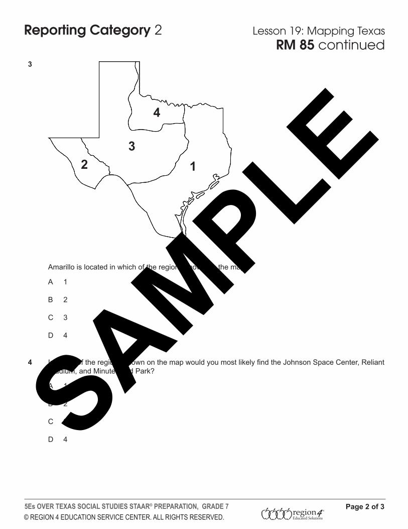
3 Amarillo is located in which of the regions shown on the map?
A 1
B 2
C 3
D 4
4 In which of the regions shown on the map would you most likely find the Johnson Space Center, Reliant Stadium, and Minute Maid Park?
A 1
B 2
C 3
D 4
Page 2 of 3
RM 85 continued
123
4
SAMPLE
© REGION 4 EDUCATION SERVICE CENTER. ALL RIGHTS RESERVED.5Es OVER TEXAS SOCIAL STUDIES STAAR® PREPARATION, GRADE 7
Reporting Category 2 Lesson 19: Mapping Texas
Page 3 of 3
Performance AssessmentYou are a travel agent. Prepare a trip itinerary of Texas for a group of visiting tourists. Include at least two points of interest from each of the four regions of Texas.
RM 85 continued
SAMPLE