s3 leo cwrsuptake - marswiki.jrc.ec.europa.eu · • what are the acceptable “administrative”...
TRANSCRIPT
20/03/2017
1
Inter-service Brainstorming workshop
on Copernicus and the CAP 17th March 2017, JRC Ispra, Italy
Short history of the introduction of the
Controls with Remote Sensing in the IACS
Olivier LEO JRC- D5
http://ies-intranet.jrc.it/h04/apps/Chrono/22090.ppt
Content
Already 2 historical retrospectives
in 98 @ CwRS conference in Venezia …
in 2012 @ CwRS Conference in Paphos
So focus here on the early years of CwRS development
Identify a few relevant stories
some success factors of potential interest for Copernicus & CAP !
2
20/03/2017
2
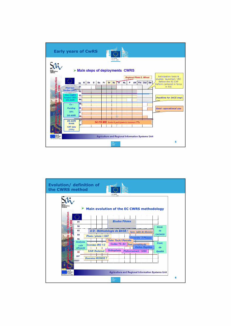
IACS overall structure
Defined in 1992 CAP Reform, thanks to pilot projects by JRC and
experience of a few Member-States (esp. ITA) See Michel Jacquot (Venezia conf 98)
3
Administrative
&
Cross checks
Farmer’s claims
Risk Analysis
Farm
Register
On-The-Spot
Controls
Animal Register
Parcel Register
CAP 92 reg. provided also
some legal basis for the use
of remote sensing in IACS
but it was more general
principle than detailed
methods !
?? Remote sensing ??
Early years of CwRS
Main initial rationale and interest of RS - An EC contribution to the MS challenge to implement IACS
- Allowed MS to focus on IACS databases and IT system
- Potential of controlling past in time and past years (eligibility arable
/ 5y reference period)
- Deterrent effect of earth observation…
A very progressive implementing - Pilot testing in different EU contexts, funded then co-funded by
AGRI, before complete transfer in EU MS
Circa 5 years to reach operation and detailed methodologies
Created a technical platform with MS • to discuss finding, build standards rules and common specs
• Increased transparency and provided clear insight on OTSC and IACS
Several unexpected outcomes
4
20/03/2017
3
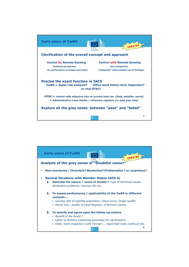
Early years of CwRS
5
Anticipation tests & studies launched / JRC
Before the 92 CAP Reform (entered in force
in 93)
Deadline for IACS impl.
Semi -operational use
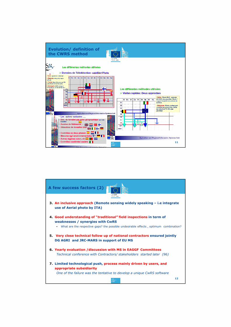
Evolution/ definition of the CWRS method
6
Main evolution of the EC CWRS methodology
20/03/2017
4
Early years of CwRS
Clarification of the overall concept and approach
Control by Remote Sensing Control with Remote Sensing
Technical perspective User perspective
(ex performance of images and tools) (integrated with practical use of findings)
Precise the exact function in IACS CwRS = Super risk analysis? Office work before farm inspection?
or real OTSC?
OTSC = control with objective info on current land use (field, satellite, aerial)
≠ Administrative cross checks / reference registers (or past year info)
Explore all the grey zones between “pass” and “failed”
7
Early years of CwRS
Analysis of the grey zones or “Doubtful cases?”
• Non-conclusive / Uncertain? Borderline? Problematics ? or suspicious?
• Several iterations with Member States IACS to
1. Describe the nature / cause of doubts ? Type of technical issues,
declarative problems, missing info etc…
2. To assess performance / applicability of the CwRS in different
contexts ...
• success rate of satellite acquisition, Cloud cover, image quality
• Parcel size , quality of Land Register, of farmers claims…
3. To specify and agree upon the follow-up actions
• Benefit of the doubt ?
• Letter to farmers (reporting anomalies for clarification)
• Field / farm inspection (with Farmer) … rapid field visits (without) etc.
8
20/03/2017
5
Early years of CwRS
Building clear rules and common standards
• Categorisation of dossiers• Decisions rules at group /dossier levels “ACCEPTED” “REJECTED”
• Completeness of the control … “COMPLETED” “UNCOMPLETE”
• What are the acceptable “administrative” tolerances ???
• Triggered actions (farm/field visit, correction/sanctions, IACS, LPIS..)
• Technical tolerances• At parcel level
• In accordance with state of the art of field measurement
• Cost efficiency analysis exercises
• General convergence within OTSC (CwRS or traditional field
inspections)
9
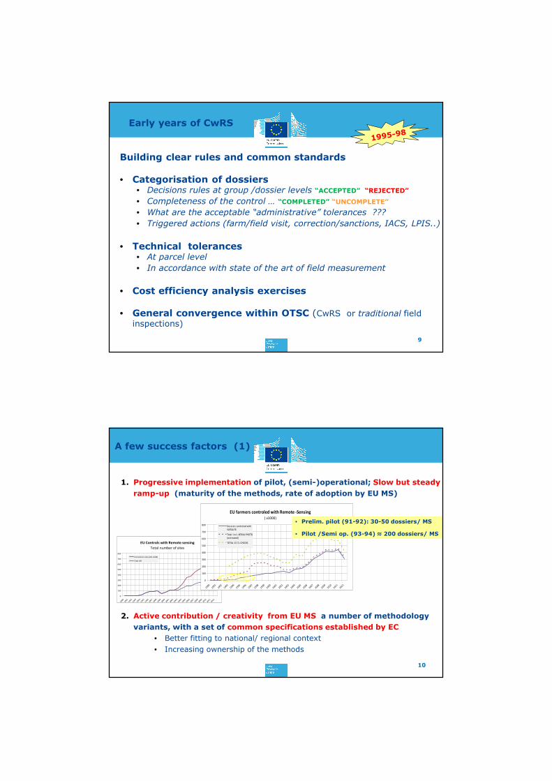
A few success factors (1)
1. Progressive implementation of pilot, (semi-)operational; Slow but steady
ramp-up (maturity of the methods, rate of adoption by EU MS)
2. Active contribution / creativity from EU MS a number of methodology
variants, with a set of common specifications established by EC
• Better fitting to national/ regional context
• Increasing ownership of the methods
10
EU Controls with Remote sensing
Total number of sites
0
100
200
300
400
500
600
700
800
1990
1991
1992
1993
1994
1995
1996
1997
1998
1999
2000
2001
2002
2003
2004
2005
2006
2007
2008
2009
2010
2011
2012
EU Control sites (HR +VHR)
Sites HR
EU farmers controled with Remote -Sensing
( x1000)
0
100
200
300
400
500
600
700
800
19901991
19921993
19941995
19961997
19981999
20002001
20022003
20042005
20062007
20082009
20102011
2012
Dossiers controled with
SATELLITE
Total incl . AERIAL PHOTO
(estimated)
TOTAL O.T.S. CHECKS
• Prelim. pilot (91-92): 30-50 dossiers/ MS
• Pilot /Semi op. (93-94) ≈ 200 dossiers/ MS
20/03/2017
6
Evolution/ definition of the CWRS method
11
A few success factors (2)
3. An inclusive approach (Remote sensing widely speaking – i.e integrate
use of Aerial photo by ITA)
4. Good understanding of “traditional” field inspections in term of
weaknesses / synergies with CwRS
• What are the respective gaps? the possible undesirable effects , optimum combination?
5. Very close technical follow up of national contractors ensured jointly
DG AGRI and JRC-MARS in support of EU MS
6. Yearly evaluation /discussion with MS in EAGGF Committees
Technical conference with Contractors/ stakeholders started later (96)
7. Limited technological push, process mainly driven by users, and
appropriate subsidiarity
One of the failure was the tentative to develop a unique CwRS software
12
20/03/2017
7
Unexpected consequences
Further impacts from CwRS on IACS
• Declarative system – report anomalies/ Provision of maps to farmers
• Introduction of GNSS & Parcel measurement (first tests 93- 94)
leading to EU recommendation & Technical tolerances regularly updated,
Proficiency testing… a comprehensive framework for RS VHR and GNSS
More generally fair system also available to Farmers
• Digital LPIS (2000-2005) Dedicated land parcel systems based on ortho-
image replace most of the external Land Registers (Cadastre)… LPIS
Specifications updating, and LPIS QA. 13
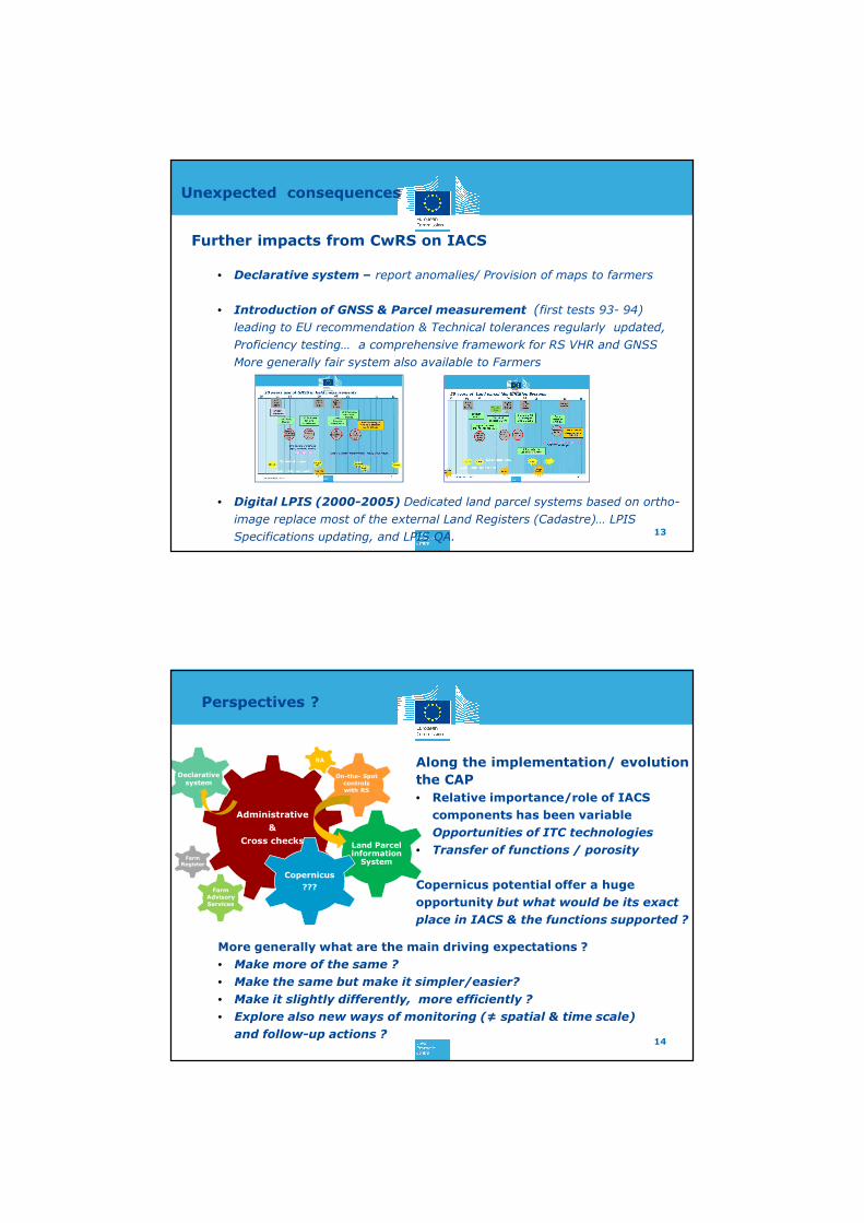
Perspectives ?
Along the implementation/ evolution
the CAP
• Relative importance/role of IACS
components has been variable
• Opportunities of ITC technologies
• Transfer of functions / porosity
Copernicus potential offer a huge
opportunity but what would be its exact
place in IACS & the functions supported ?
14
Administrative
&
Cross checksLand Parcel information
System
Declarative system
RA
Farm Register
On-the- Spot controls with RS
Copernicus
???Farm Advisory Services
More generally what are the main driving expectations ?
• Make more of the same ?
• Make the same but make it simpler/easier?
• Make it slightly differently, more efficiently ?
• Explore also new ways of monitoring (≠ spatial & time scale)
and follow-up actions ?

20/03/2017
8
Thanks for your attention !