rya dot yachtmaster ocean / astro class 4. course · pdf filerya dot yachtmaster ocean / astro...
TRANSCRIPT
RYA DOT Yachtmaster Ocean / Astro Class 4.
Course Content
Basics,History, Time, Longitude and Latitude, The Sextant.
Essentials,Ships Log, Ocean Charts, Sextant, Time Piece, Sight Book, Nautical Almanac, Sight Reduction Tables, Sight Forms, Plotting Sheets & Instruments.
The Sextant, Cleaning, Using, Errors, True Sextant Angles.The Books, Nautical Almanac, Sight Reduction Tables.
The “Big Picture” Data Flow.The Sun Sight Sun, Run, Sun.A Daily Fix Morning, Noon and Night.Planet Sights.Star Sights Planning a Star Chart, Precession and Nutation, Polaris.The Moon.
Meteorology Tropical Revolving Storms, Air MassesPassage Planning Ocean Routes, Charts and Books.Preparation of Vessel. Rations, Water, Fuel, Safety.Crew Selection and Management
RYA / DOT Yachtmaster OceanRevised Course for 2007 Onward
Day is a concept born of planets spinning captive about a star...
Simon S Bradshaw +44 (0) 79 222 333 84 [email protected]
1
Loomings
Some years ago - never mind how long precisely – having little or no money in my purse, and nothing particular to interest me on-shore, I thought I would sail about a little and see the watery part of the world. It is a way I have of driving off the spleen, and regulating the circulation. Whenever I find myself growing grim about the mouth; whenever it is a damp, drizzly November in my soul; whenever I find myself involuntarily pausing before coffin warehouses and bringing up the rear of every funeral I meet; and especially whenever my hypos get such an upper hand of me, that it requires a strong moral principal to prevent me from deliberately stepping into the street, and methodically knocking peoples hats off – then, I account it high time to get to the sea as soon as I can. This is my substitute for pistol and ball. With a philosophical flourish Cato throws himself upon his sword; I quietly take to the ship.
- H. Melville (Moby Dick, 1851)
The planet Earth and its other eight companions revolve about a small star know as the Sun. The mechanics of these revolving planets have been known and measured for thousands of years. The bigger problems of time and accurate measurement of angles have only been solved in later years. Man has for many years used the Moon as a celestial sign post, but for accurate position fixing there are problems with the Moon.Polaris, the Pole Star, was thought for a good many years to be fixed in its position above the North Pole as it appears to remain stationary with the heavens revolving around it. In simple terms the angle between it and the horizon is equal to the latitude of the observer.The Sun is also a very tempting target for position fixing. The very brightness of the Sun is both its attraction and its problem. The speed of its travel across the sky is also of great interest to the Astro Navigator.
The Royal Observatory was established at Greenwich in the 15th Century. King Henry VII financed the creation and building of the great observatory to study, record and predict the movement and angle of the Sun, Moon and Stars.
RYA / DOT Yachtmaster OceanRevised Course for 2007 Onward
Day is a concept born of planets spinning captive about a star...
Simon S Bradshaw +44 (0) 79 222 333 84 [email protected]
2
TIME (and longitude)
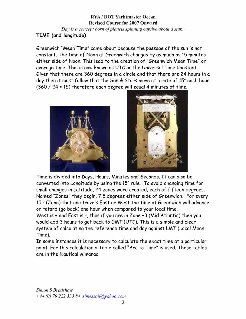
Greenwich “Mean Time” came about because the passage of the sun is not constant. The time of Noon at Greenwich changes by as much as 15 minutes either side of Noon. This lead to the creation of “Greenwich Mean Time” or average time. This is now known as UTC or the Universal Time Constant.Given that there are 360 degrees in a circle and that there are 24 hours in a day then it must follow that the Sun & Stars move at a rate of 15o each hour (360 / 24 = 15) therefore each degree will equal 4 minutes of time.
Time is divided into Days, Hours, Minutes and Seconds. It can also be converted into Longitude by using the 15o rule. To avoid changing time for small changes in Latitude, 24 zones were created, each of fifteen degrees. Named “Zones” they begin, 7.5 degrees either side of Greenwich. For every 15 o (Zone) that one travels East or West the time at Greenwich will advance or retard (go back) one hour when compared to your local time.West is + and East is -, thus if you are in Zone +3 (Mid Atlantic) then you would add 3 hours to get back to GMT (UTC). This is a simple and clear system of calculating the reference time and day against LMT (Local Mean Time).In some instances it is necessary to calculate the exact time at a particular point. For this calculation a Table called “Arc to Time” is used. These tables are in the Nautical Almanac.
RYA / DOT Yachtmaster OceanRevised Course for 2007 Onward
Day is a concept born of planets spinning captive about a star...
Simon S Bradshaw +44 (0) 79 222 333 84 [email protected]
3
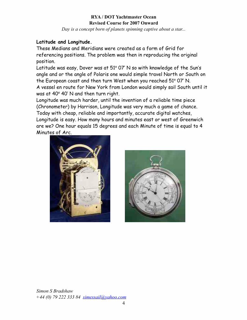
Latitude and Longitude.These Medians and Meridians were created as a form of Grid for referencing positions. The problem was then in reproducing the original position. Latitude was easy, Dover was at 51o 07’ N so with knowledge of the Sun’s angle and or the angle of Polaris one would simple travel North or South on the European coast and then turn West when you reached 51o 07’ N.A vessel en route for New York from London would simply sail South until it was at 40o 40’ N and then turn right. Longitude was much harder, until the invention of a reliable time piece (Chronometer) by Harrison, Longitude was very much a game of chance. Today with cheap, reliable and importantly, accurate digital watches, Longitude is easy. How many hours and minutes east or west of Greenwich are we? One hour equals 15 degrees and each Minute of time is equal to 4 Minutes of Arc.
RYA / DOT Yachtmaster OceanRevised Course for 2007 Onward
Day is a concept born of planets spinning captive about a star...
Simon S Bradshaw +44 (0) 79 222 333 84 [email protected]
4
The Sextant
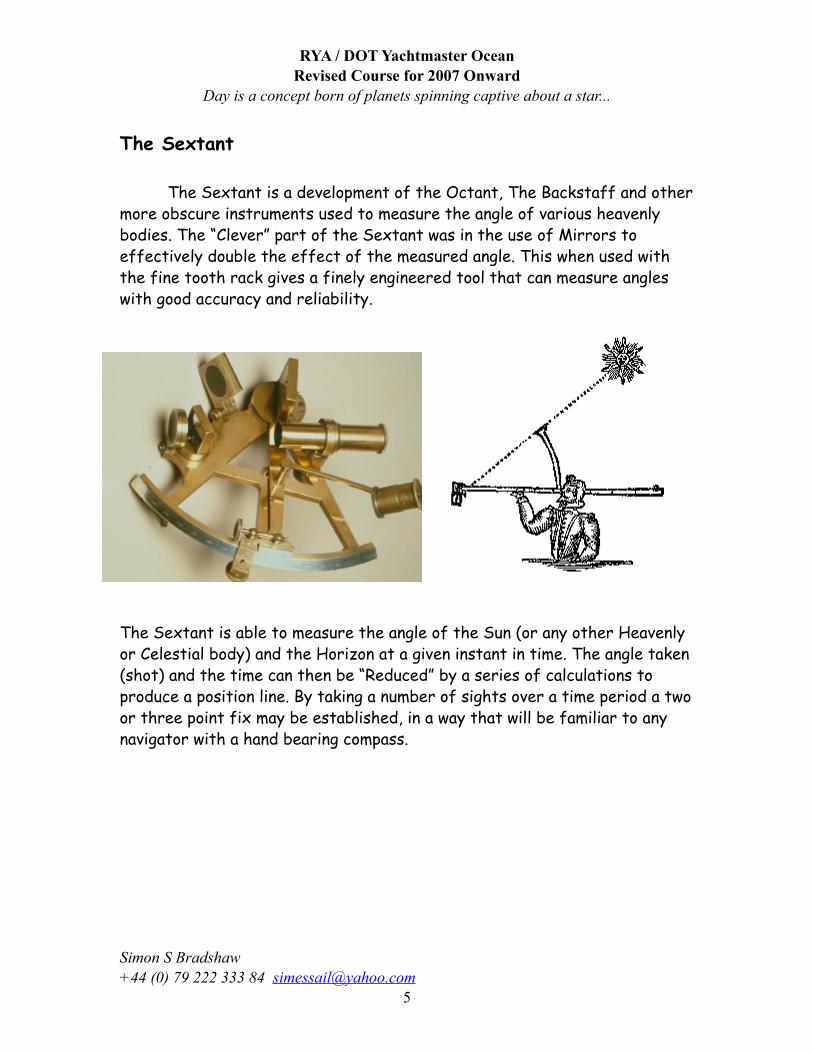
The Sextant is a development of the Octant, The Backstaff and other more obscure instruments used to measure the angle of various heavenly bodies. The “Clever” part of the Sextant was in the use of Mirrors to effectively double the effect of the measured angle. This when used with the fine tooth rack gives a finely engineered tool that can measure angles with good accuracy and reliability.
The Sextant is able to measure the angle of the Sun (or any other Heavenly or Celestial body) and the Horizon at a given instant in time. The angle taken (shot) and the time can then be “Reduced” by a series of calculations to produce a position line. By taking a number of sights over a time period a two or three point fix may be established, in a way that will be familiar to any navigator with a hand bearing compass.
RYA / DOT Yachtmaster OceanRevised Course for 2007 Onward
Day is a concept born of planets spinning captive about a star...
Simon S Bradshaw +44 (0) 79 222 333 84 [email protected]
5
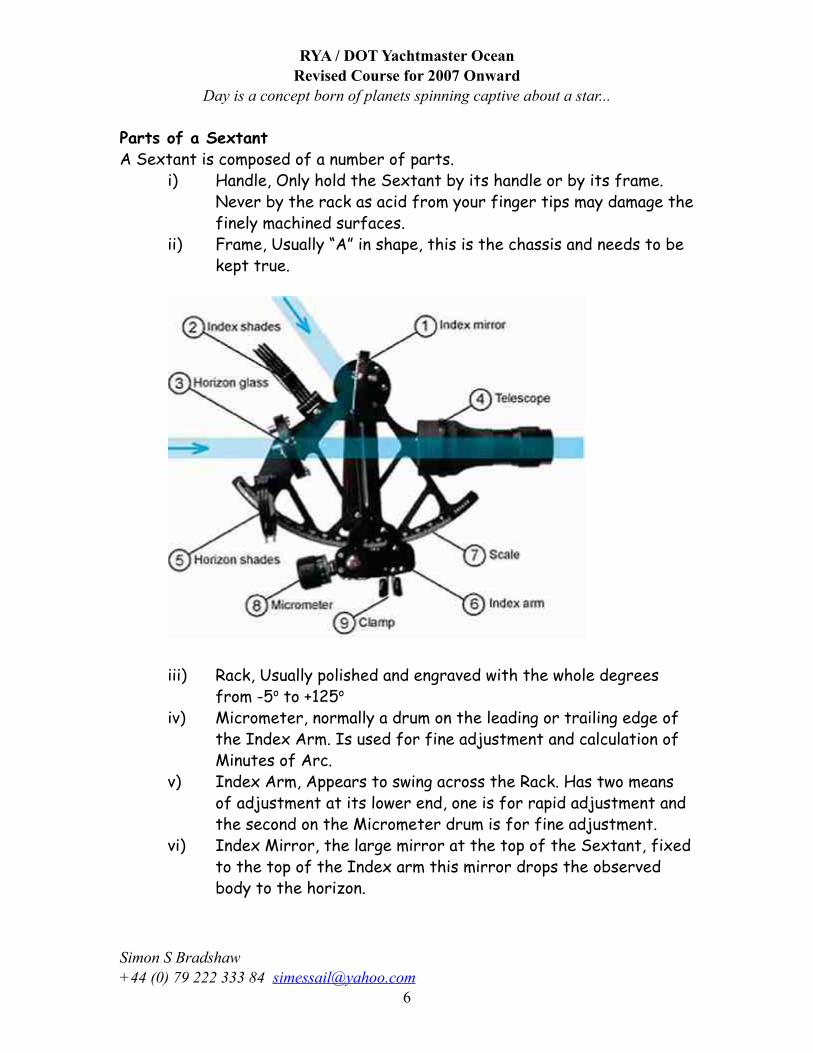
Parts of a SextantA Sextant is composed of a number of parts.
i) Handle, Only hold the Sextant by its handle or by its frame. Never by the rack as acid from your finger tips may damage the finely machined surfaces.
ii) Frame, Usually “A” in shape, this is the chassis and needs to be kept true.
iii) Rack, Usually polished and engraved with the whole degrees from -5o to +125o
iv) Micrometer, normally a drum on the leading or trailing edge of the Index Arm. Is used for fine adjustment and calculation of Minutes of Arc.
v) Index Arm, Appears to swing across the Rack. Has two means of adjustment at its lower end, one is for rapid adjustment and the second on the Micrometer drum is for fine adjustment.
vi) Index Mirror, the large mirror at the top of the Sextant, fixed to the top of the Index arm this mirror drops the observed body to the horizon.
RYA / DOT Yachtmaster OceanRevised Course for 2007 Onward
Day is a concept born of planets spinning captive about a star...
Simon S Bradshaw +44 (0) 79 222 333 84 [email protected]
6
vii) Horizon Mirror, Mounted opposite the Telescope this mirror may be either split or whole view, Split Image is more common. The image from the Index Mirror is reflected through half of this Mirror.
viii) Telescope, Usually a 4X magnification and focus adjustment.ix) Filters (Shades), Both mirrors have filters (shades) and all
should be used. Always start off with all the filters in place and remove them one by one, until you have the correct amount of light. This is a 4X telescope and magnifying the Suns rays by 4 will permanently damage your eyes!
x) Lanyard, Always use the lanyard, even when at home practising, even a small impact can damage your Sextant beyond reasonable use.
Care and use of the SextantAll Sextants are “Right” handed, so lift it from the box by your left hand and then you can transfer it to your right easily.Always use the darkest of the filters (shades) over both mirrors, Handle the Sextant by the frame and handle only.Use the Lanyard at all times.Check the Index error before each sight, it should be constant. If not, the most likely cause is a small impact on one of the mirrors. Check and adjust using the small adjusting screws on the back of the mirrors.
If you are using a Plastic Sextant then you may find that heat distortion is a problem. Heat distortion caused by the sun’s rays can cause index error to vary by as much as 10’. Check the index error both before and after each sight, make a note of the error once the heat has stabilised.
RYA / DOT Yachtmaster OceanRevised Course for 2007 Onward
Day is a concept born of planets spinning captive about a star...
Simon S Bradshaw +44 (0) 79 222 333 84 [email protected]
7
Adjustments and Errors. Sextant adjustments are relatively simple and easy to perform. However, if the error is less than 5’ then these small errors can be taken into account during the basic calculations.If adjustment is required then perform them in the following order;
i) Check the Index Mirror. This should be perpendicular to the frame. With the Index Arm at 50 to 60o and the Sextant held sideways with the rack away from you, view both the rack and the reflected image of the rack in the Index Mirror. Both should be a single continuous line. Any deviance is evidence of the Mirror being out of true. Use the screw adjusters on the back of the mirror to correct.
ii) Check the Horizon Mirror. This again is to check the mirror is correctly aligned with the frame. On land, sight a building roof or a bridge, rock the sextant slightly the image and the reflected image should remain true. If there is any deviance, you will need to adjust the single screw on the back of the mirror.
iii) At Sea you will have to use the horizon, slowly tilt the Sextant to 45 o if the horizon remains constant across the reflected image, no adjustment is necessary. However, if the horizon is broken, you will need to adjust the single screw behind the mirror.
iv) Check for Index Error. You will perform this check prior to every sight. Set the index arm to 0 o and sight the horizon (or something at least 1 mile distant). If the Horizon (or the object you are using) is constant and un-broken then your Sextant is set up correctly. If however the image is broken, the reflected horizon will be either above or below the direct image, use the top screw to adjust the horizon mirror (or glass) until the image is unbroken. It is good practise to check your Sextant for Index Error prior to each sight.
v) With the Index arm and index drum set to zero, sight the horizon. Should the horizon be broken, use the index drum to bring the horizon back into true. Read the Index drum and make a note of the result. If the adjustment was a positive one (+) then you will have to remove this from your subsequent sight if it is Negative (-) then you will need to add it to your sight.
RYA / DOT Yachtmaster OceanRevised Course for 2007 Onward
Day is a concept born of planets spinning captive about a star...
Simon S Bradshaw +44 (0) 79 222 333 84 [email protected]
8
Please treat your Sextant as a very delicate instrument; the more you adjust it the slacker the screws will become and the more you will need to adjust it, a vicious circle.
If you make an adjustment to your Sextant you should then recheck it several times to be sure that you have trapped the error.Venus is a good check, it should appear as a single image when viewed directly. Use the horizon to remove all error.
Wash your Sextant in a little clean warm water to remove salt water spray. Clean the mirrors with a good quality optical cleaning fluid. Lubricate very sparingly with light machine oil, being careful to remove any dust or grit from the rack beforehand.
Keep the Sextant in its box at all times when not in use, keep the boxed Sextant in a secure position on board, this should be secure from violent movement.
RYA / DOT Yachtmaster OceanRevised Course for 2007 Onward
Day is a concept born of planets spinning captive about a star...
Simon S Bradshaw +44 (0) 79 222 333 84 [email protected]
9
Taking the Sight
Find a secure seated position as high (> 4m is good) as is possible whilst remaining safe. Back support is a definite plus. Remember to use the Sextant’s lanyard. Have your sight book and time piece to hand.
Check and take a note of the Index Error, use the horizon opposite the sun for greatest contrast, remember to use the filters.
Set the Index arm to Zero and set the darkest filters in place. Holding the Sextant by its handle with your right hand, place your
left hand on the index arm. Release levers and view the sun through the Sextant’s telescope. Remove the filters one by one until you can see the sun with no discomfort.
You should be able to see two images of the sun; the true (direct) image and the reflected image.
Carefully squeeze the Index Arm Leavers and rotate the Sextant with your right hand, keeping the reflected image of the sun in view. Keep rotating your hand until you have the Sextant pointing roughly at the horizon.
Now release the Index Arm leavers, allowing the gear to engage with the rack.
Remove the direct filter so that you are able to view the horizon easily. Now using the drum bring the reflected image of the sun down until the lower limb (bottom) of the sun just touches the horizon. Now gently rock the Sextant from side to side, this will cause the image of the sun to roll from side to side allowing you to check the accuracy of the sight.
Immediately note the exact time to the nearest second. Recording Day, Hours, Minutes and seconds. Note whether you are using LMT or GMT (UTC) together with any time piece error (A chronograph is a time piece with a known rate of error)
Note the Minutes (to the nearest 0.1’) and degrees. You should also note the name of the body observed, whether you have taken its Upper Limb (UL) or its Lower Limb(LL). UL is normally only with the Moon. Note also Index Error, Ship’s log and DR position.
RYA / DOT Yachtmaster OceanRevised Course for 2007 Onward
Day is a concept born of planets spinning captive about a star...
Simon S Bradshaw +44 (0) 79 222 333 84 [email protected]
10
The most common errors in taking a sight are;
• Misreading the Sextant by one degree; usually when the angle includes high numbers of minutes (this will move your position by 60 miles) and is normally trapped when plotting your position.
• Not rocking the Sextant to check that you have obtained a true angle. This often gives errors in angle of 5’ to 10’ greater than it should be. This will manifest itself as a position line nearer the sun. (A check with GPS will help to trace this fault and cure it).
• Not sighting the true horizon (3 – 5 miles away) but bringing the sun down to the top of a swell that is only 1 – 2 miles away. Moving the observer’s height of eye up to around 4 meters will usually cure this.
• Insufficient practise. Work with a friend and compare angles made directly against each other, you should improve rapidly.
Equipment Needed
Ships Log, Date, Time, Course, Distance run, Variation / Deviation, Barometer, Wind Direction / Force, Sea State.
Charts, Planning, Coastal and Ocean Passage.Sextant, Modern and Metal ideally.Time Piece Accurate and Digital in a ideal world.Sight Book, Date, Time, Sextant Angle, Body, Log, and D.R.Nautical Almanac HMSO NP314 or USA Commercial EditionSight Reduction Tables Air Navigation AP3270 or USA HO-249 VOL. I – Selected Stars latest epoch VOL. II – LAT 0o - 40 o
VOL.III – Lat 40 o - 89 o
Sight Forms Sun, Sun Meridian Passage, Moon, Polaris, Stars, Planets.
Plotting Sheets Purchased, Downloaded or Home ProducedPlotting Instruments Plotter, Parallel Rules, Dividers, Pencils, Rubber.SSB Receiver Time Signals, Weather.
RYA / DOT Yachtmaster OceanRevised Course for 2007 Onward
Day is a concept born of planets spinning captive about a star...
Simon S Bradshaw +44 (0) 79 222 333 84 [email protected]
11
RYA / DOT Yachtmaster OceanRevised Course for 2007 Onward
Day is a concept born of planets spinning captive about a star...
Simon S Bradshaw +44 (0) 79 222 333 84 [email protected]
12
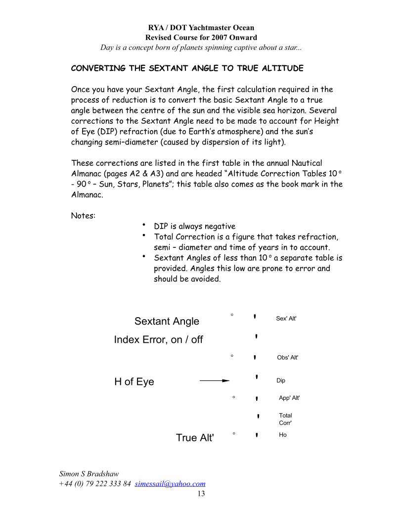
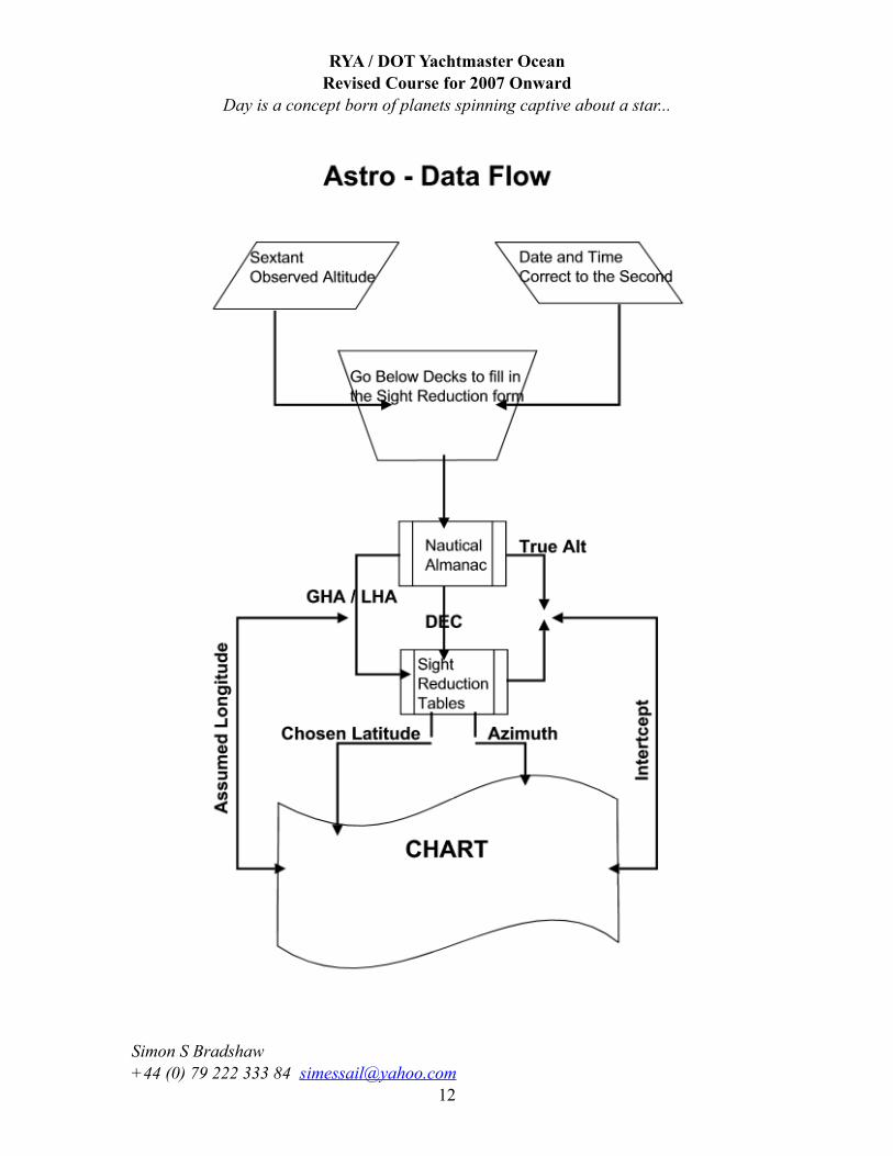
CONVERTING THE SEXTANT ANGLE TO TRUE ALTITUDE
Once you have your Sextant Angle, the first calculation required in the process of reduction is to convert the basic Sextant Angle to a true angle between the centre of the sun and the visible sea horizon. Several corrections to the Sextant Angle need to be made to account for Height of Eye (DIP) refraction (due to Earth’s atmosphere) and the sun’s changing semi–diameter (caused by dispersion of its light).
These corrections are listed in the first table in the annual Nautical Almanac (pages A2 & A3) and are headed “Altitude Correction Tables 10 o - 90 o – Sun, Stars, Planets”; this table also comes as the book mark in the Almanac.
Notes:• DIP is always negative• Total Correction is a figure that takes refraction,
semi – diameter and time of years in to account.• Sextant Angles of less than 10 o a separate table is
provided. Angles this low are prone to error and should be avoided.
RYA / DOT Yachtmaster OceanRevised Course for 2007 Onward
Day is a concept born of planets spinning captive about a star...
Simon S Bradshaw +44 (0) 79 222 333 84 [email protected]
13
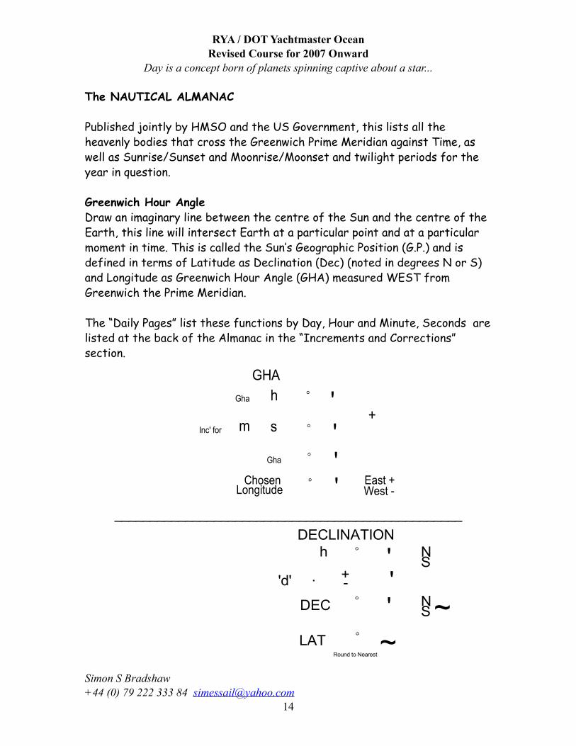
The NAUTICAL ALMANAC
Published jointly by HMSO and the US Government, this lists all the heavenly bodies that cross the Greenwich Prime Meridian against Time, as well as Sunrise/Sunset and Moonrise/Moonset and twilight periods for the year in question.
Greenwich Hour AngleDraw an imaginary line between the centre of the Sun and the centre of the Earth, this line will intersect Earth at a particular point and at a particular moment in time. This is called the Sun’s Geographic Position (G.P.) and is defined in terms of Latitude as Declination (Dec) (noted in degrees N or S) and Longitude as Greenwich Hour Angle (GHA) measured WEST from Greenwich the Prime Meridian.
The “Daily Pages” list these functions by Day, Hour and Minute, Seconds are listed at the back of the Almanac in the “Increments and Corrections” section.
_________________________________________________
RYA / DOT Yachtmaster OceanRevised Course for 2007 Onward
Day is a concept born of planets spinning captive about a star...
Simon S Bradshaw +44 (0) 79 222 333 84 [email protected]
14
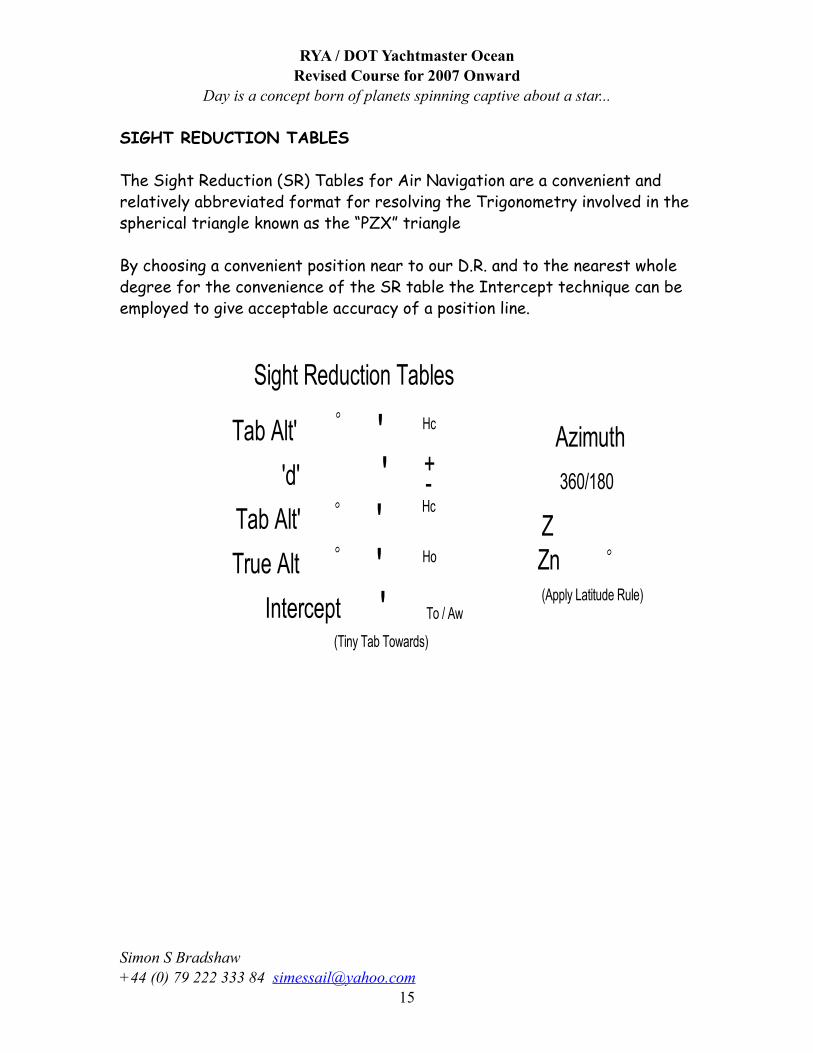
SIGHT REDUCTION TABLES
The Sight Reduction (SR) Tables for Air Navigation are a convenient and relatively abbreviated format for resolving the Trigonometry involved in the spherical triangle known as the “PZX” triangle
By choosing a convenient position near to our D.R. and to the nearest whole degree for the convenience of the SR table the Intercept technique can be employed to give acceptable accuracy of a position line.
RYA / DOT Yachtmaster OceanRevised Course for 2007 Onward
Day is a concept born of planets spinning captive about a star...
Simon S Bradshaw +44 (0) 79 222 333 84 [email protected]
15
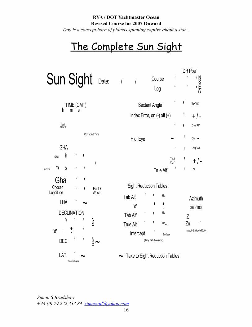
The Complete Sun Sight
RYA / DOT Yachtmaster OceanRevised Course for 2007 Onward
Day is a concept born of planets spinning captive about a star...
Simon S Bradshaw +44 (0) 79 222 333 84 [email protected]
16
SOME NOTES AND THOUGHTS ON THE PROCEDURE FOR TAKING SUN SIGHTS.
Make a note of the Date, the D.R. Position, the Time, Sextant Angle, UL or LL, Index Error, Height of Eye all in the appropriate box on the form.
The Process, Stage 1, find the “TRUE ALTITUDE” (Ho) by applying THREE corrections to the Sextant Angle as follows:
INDEX ERROR; The index error should be checked before each and every sight (using the horizon opposite the sun for maximum contrast) so that minor errors in the instrument can be eliminated from the calculation. I/E must be added or subtracted (on is off & off is on) to give the correct Observed Altitude.
DIP Correction; Using the Altitude Correction Table (or the card that comes as a book mark) in the Nautical Almanac for the year, extract the DIP correction for Height of Eye (H of E) from the top right panel of this table. When subtracted from the Observed Altitude this will result in the Apparent Altitude (App Alt)
Total Correction (Semi-Diameter & Refraction). From the Sun Table, on the left hand side of the Table, enter the appropriate column for the month then find the value of degrees & minutes which are closest to your App Alt., then the total correction is read for UL (-) or LL(+) and applied to App Alt to give True Altitude (Ho).
Transfer the True Alt to the bottom of the form as indicated.
Stage 2, Find the Sun’s Geographic Position at the precise GMT (UTC) of the
sight in terms of Greenwich Hour Angle (GHA – the Sun’s longitude measured WEST of Greenwich Prime Meridian) and Declination (Dec - the Sun’s Latitude measured N or S), using the Nautical Almanac.
RYA / DOT Yachtmaster OceanRevised Course for 2007 Onward
Day is a concept born of planets spinning captive about a star...
Simon S Bradshaw +44 (0) 79 222 333 84 [email protected]
17
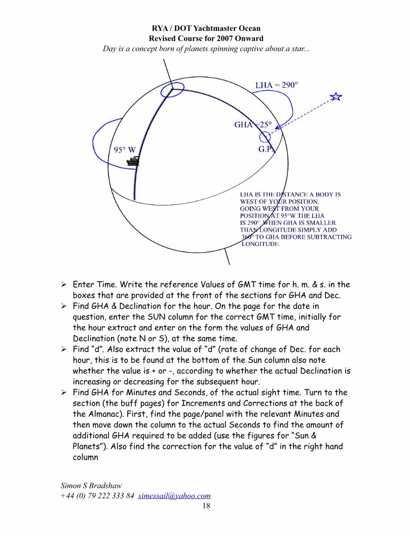
Enter Time. Write the reference Values of GMT time for h. m. & s. in the boxes that are provided at the front of the sections for GHA and Dec.
Find GHA & Declination for the hour. On the page for the date in question, enter the SUN column for the correct GMT time, initially for the hour extract and enter on the form the values of GHA and Declination (note N or S), at the same time.
Find “d”. Also extract the value of “d” (rate of change of Dec. for each hour, this is to be found at the bottom of the Sun column also note whether the value is + or -, according to whether the actual Declination is increasing or decreasing for the subsequent hour.
Find GHA for Minutes and Seconds, of the actual sight time. Turn to the section (the buff pages) for Increments and Corrections at the back of the Almanac). First, find the page/panel with the relevant Minutes and then move down the column to the actual Seconds to find the amount of additional GHA required to be added (use the figures for “Sun & Planets”). Also find the correction for the value of “d” in the right hand column
RYA / DOT Yachtmaster OceanRevised Course for 2007 Onward
Day is a concept born of planets spinning captive about a star...
Simon S Bradshaw +44 (0) 79 222 333 84 [email protected]
18
Calculate GHA and Declination. Compute the values of GHA and Declination in degrees and minutes, for the precise GMT time at which the sight was taken.
Transfer Declination. Transfer the value of Declination, in degrees and minutes (Nearest whole number), to the Boxes indicated on the form as * Dec for later use with the Sight Reduction Tables.
Stage 3Establish a Chosen Longitude, such that when it is applied to the GHA it will result in a Local Hour Angle (the angular Difference between our Longitude and the Sun’s Longitude, always measured Westwards and known as “LHA”) of whole degrees only. For the convenience of the Sight Reduction Tables for Air Navigation.
Decide upon your Minutes of Chosen LongitudeInitially, from the DR position, Note E+ or W-If EAST: Enter and amount of minutes which when added to those in the GHA box will total 60 (or one degree). This is then carried forward during the subsequent addition.If WEST: Make the amount of minutes the same as those in the GHA box, so that when subtracted the result will be ZERO minutes.
Decide Degrees of Chosen Longitude. Select a number of degrees such that the resulting Chosen Longitude is within 30’ of the DR Longitude.
Calculate the Local Hour Angle (LHA). Add an EASTERLY (E) or Subtract a WESTERLY (W), Chosen Longitude to from the GHA to give the * LHA.
When Dealing With E Longitudes, it is possible that the addition results in a number of degrees greater than 360, if this happens simply subtract 360 to bring the range with in the 0 to 360o (Do not forget to carry the minutes forward)
In the case of WEST Longitudes, it is important that the chosen Longitude is subtracted FROM the GHA and not vice-versa; if the GHA is too small, add 360 to it before subtracting.
RYA / DOT Yachtmaster OceanRevised Course for 2007 Onward
Day is a concept born of planets spinning captive about a star...
Simon S Bradshaw +44 (0) 79 222 333 84 [email protected]
19
Find Chosen Latitude. Using the DR Latitude figure, round up or down to the nearest whole degree and put the result in the box marked * LAT, noting N or S as appropriate.
Stage 4. Given the three values marked * (LHA, LAT and Dec.) the Sight Reduction Tables (SRT) for Air Navigation are used so as to avoid complicated mathematics (resolution of the PZX triangle) in finding the AZIMUTH (Zn) and INTERCEPT, which will be used to establish a position line. Determining Tabulated Altitude (Hc). Use either SRT Vol. 2 or 3
depending upon the Latitude required and turn to pages for * LATo value from the sight form.
Find section with the range of Declination, 0o – 14o or 15o – 29o, that contains the value of *Dec. (in whole degrees) filled in on the sight form.Then turn to the section for SAME NAME if Lat and Dec are both North or both South, or alternatively use the CONTRARY NAME section if LAT and Dec. are opposite.Finally, find the line for * LHA using the far left or right columns and the *Dec. in degrees.Extract the values for Tabulated Altitude (Hc), the +- ‘d’ (Note the + or – sign in the column also) and the ‘Z’ figures, placing them in the appropriate boxes. Determining AZIMUTH (Zn). To find Azimuth (Zn) from the ‘Z’ figure,
use either N or S latitude rule shown at the top and bottom of each page of the SRT according to DR position.
Increment for Minutes of Declination. Turn to Table 5, at the rear of either Vol. 2 or 3 of SRT to obtain the final correction for ‘d’ and minutes of Declination (mdec). Read ‘d’ value along the top and mdec figure vertically, extract value where the line and column intersect. Add or subtract according to the sign of ‘d’, to give Tabulated Altitude (Hc) and enter the value into the box.
Find INTERCEPT. Compare the Tabulated and True Altitudes, subtract the smaller from the larger to give the value of the INTERCEPT, name the result as TO (towards) or AW (Away from) according to the rule on the form (True greater that Tab = towards, Tab greater than True = Away from).
RYA / DOT Yachtmaster OceanRevised Course for 2007 Onward
Day is a concept born of planets spinning captive about a star...
Simon S Bradshaw +44 (0) 79 222 333 84 [email protected]
20
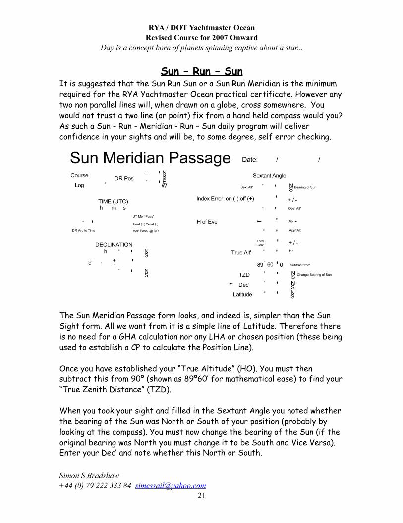
Sun – Run – SunIt is suggested that the Sun Run Sun or a Sun Run Meridian is the minimum required for the RYA Yachtmaster Ocean practical certificate. However any two non parallel lines will, when drawn on a globe, cross somewhere. You would not trust a two line (or point) fix from a hand held compass would you? As such a Sun - Run - Meridian - Run – Sun daily program will deliver confidence in your sights and will be, to some degree, self error checking.
The Sun Meridian Passage form looks, and indeed is, simpler than the Sun Sight form. All we want from it is a simple line of Latitude. Therefore there is no need for a GHA calculation nor any LHA or chosen position (these being used to establish a CP to calculate the Position Line).
Once you have established your “True Altitude” (HO). You must then subtract this from 90º (shown as 89º60’ for mathematical ease) to find your “True Zenith Distance” (TZD).
When you took your sight and filled in the Sextant Angle you noted whether the bearing of the Sun was North or South of your position (probably by looking at the compass). You must now change the bearing of the Sun (if the original bearing was North you must change it to be South and Vice Versa).Enter your Dec’ and note whether this North or South.
RYA / DOT Yachtmaster OceanRevised Course for 2007 Onward
Day is a concept born of planets spinning captive about a star...
Simon S Bradshaw +44 (0) 79 222 333 84 [email protected]
21
If your TZD and your Dec’ both have the same bearing then add them together to find your Latitude and name it the same as the matched bearing.If your TZD and Dec’ have different bearings then Subtract the lessor from the greater to find your Latitude and name it for the Greater, Easy!
RYA / DOT Yachtmaster OceanRevised Course for 2007 Onward
Day is a concept born of planets spinning captive about a star...
Simon S Bradshaw +44 (0) 79 222 333 84 [email protected]
22
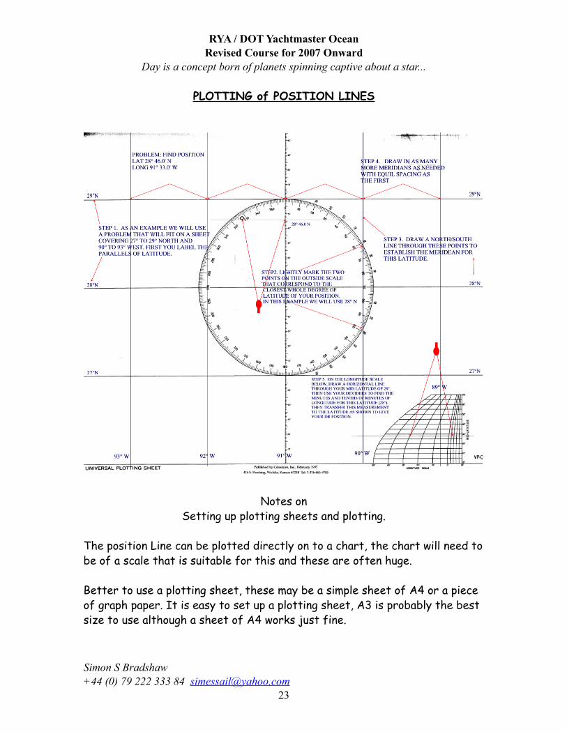
PLOTTING of POSITION LINES
Notes onSetting up plotting sheets and plotting.
The position Line can be plotted directly on to a chart, the chart will need to be of a scale that is suitable for this and these are often huge.
Better to use a plotting sheet, these may be a simple sheet of A4 or a piece of graph paper. It is easy to set up a plotting sheet, A3 is probably the best size to use although a sheet of A4 works just fine.
RYA / DOT Yachtmaster OceanRevised Course for 2007 Onward
Day is a concept born of planets spinning captive about a star...
Simon S Bradshaw +44 (0) 79 222 333 84 [email protected]
23
With the sheet laid out “Landscape”
Chosen Position Plot the CP used in the Sight Calculation
Azimuth Line Draw the azimuth as a line that passes through the Chosen Latitude and Chosen Longitude (draw the line long enough to extend from on side to the other of the CP.
Intercept This is a line measured in Nautical miles from the CP. If the Intercept is TO then draw the line Towards the Azimuth, if AW then draw the line Away from the azimuth direction.
Position Line The PL is drawn at Right Angles to the Azimuth line through the intercept point. An arrow draw on each end indicates the portion of a large position circle.
Position Fix To gain a “FIX” it is necessary to have more than one PL, either by taking further sun sights, either when the Azimuth has changed by 30 degrees or by taking a Moon or Star sight.Should you choose to take multiple sun sights then you are moving in to the realm of “transferred” position lines.
Transferred Position Lines A transferred PL is simply a PL that was in use at an earlier time and is now being moved a distance equal to the distance travelled by the vessel. Thus if at 07:00 Position Line drawn on the plotting sheet, you know that your vessel is somewhere on that line. Between 07:00 and 12:00 (The time of Mer Pass) your vessel travels 2830 and a distance of 30 M. You draw your Noon Sight line of Latitude on the plotting sheet. You know that your vessel is somewhere on this line, but where? You need to draw a line corresponding to your run since 07:00 (283o and 30 M), draw this line from anywhere on your 07:00 PL. Now pickup your 07:00 PL (your Transferred Position Line) with your rule or plotter and move it to the end of the line that represents your run of 30 M. Draw the line, maintaining the same bearing as at 07:00, so that it crosses the Mer Pass line, Your Noon Position is at the juncture of the Mer Pass and your Transferred Position line.
RYA / DOT Yachtmaster OceanRevised Course for 2007 Onward
Day is a concept born of planets spinning captive about a star...
Simon S Bradshaw +44 (0) 79 222 333 84 [email protected]
24
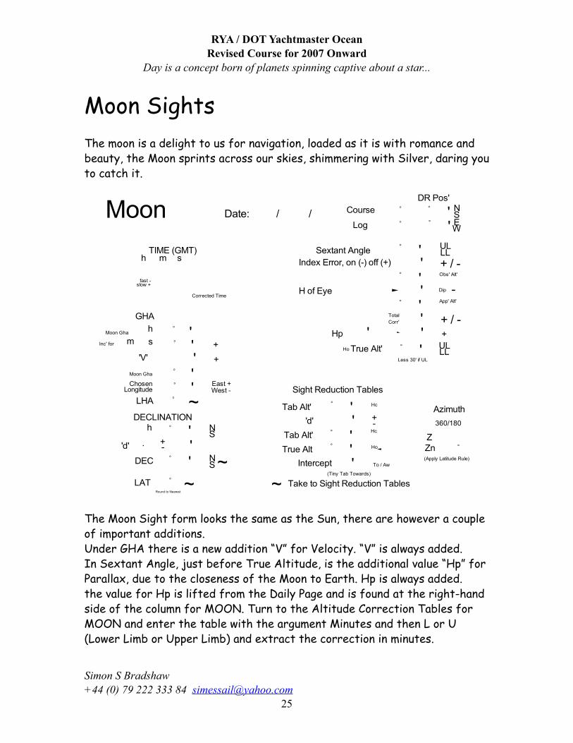
Moon SightsThe moon is a delight to us for navigation, loaded as it is with romance and beauty, the Moon sprints across our skies, shimmering with Silver, daring you to catch it.
The Moon Sight form looks the same as the Sun, there are however a couple of important additions.Under GHA there is a new addition “V” for Velocity. “V” is always added.In Sextant Angle, just before True Altitude, is the additional value “Hp” for Parallax, due to the closeness of the Moon to Earth. Hp is always added.the value for Hp is lifted from the Daily Page and is found at the right-hand side of the column for MOON. Turn to the Altitude Correction Tables for MOON and enter the table with the argument Minutes and then L or U (Lower Limb or Upper Limb) and extract the correction in minutes.
RYA / DOT Yachtmaster OceanRevised Course for 2007 Onward
Day is a concept born of planets spinning captive about a star...
Simon S Bradshaw +44 (0) 79 222 333 84 [email protected]
25
The Moon’s Altitude Correction tables are split into two divisions, 0º - 35º and 35º - 90º. Enter the table with whole degrees across the top then associated minutes to find the correction. Continue with the form until complete.Most Astro navigators dislike the Moon, Can’t think why?
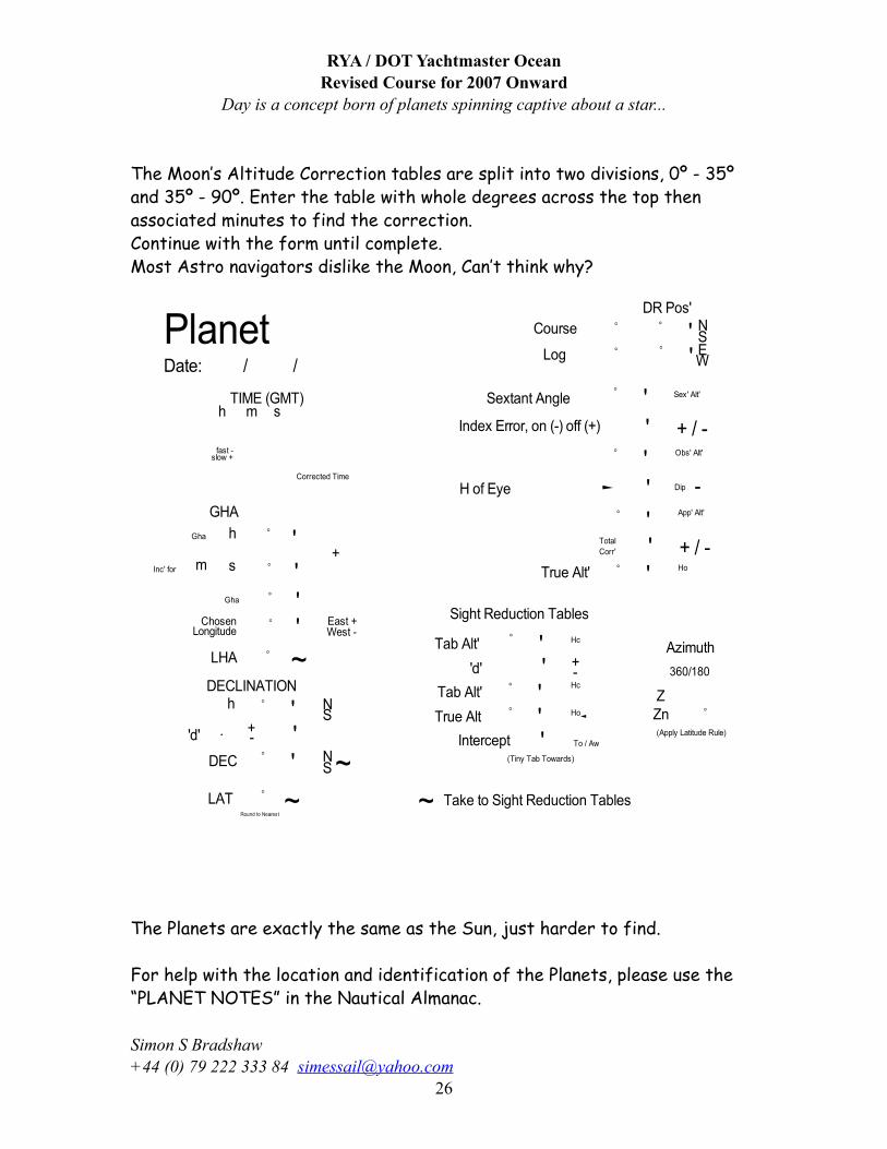
The Planets are exactly the same as the Sun, just harder to find.
For help with the location and identification of the Planets, please use the “PLANET NOTES” in the Nautical Almanac.
RYA / DOT Yachtmaster OceanRevised Course for 2007 Onward
Day is a concept born of planets spinning captive about a star...
Simon S Bradshaw +44 (0) 79 222 333 84 [email protected]
26
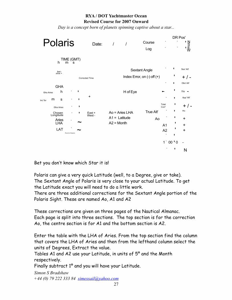
Bet you don’t know which Star it is!
Polaris can give a very quick Latitude (well, to a Degree, give or take). The Sextant Angle of Polaris is very close to your actual Latitude. To get the Latitude exact you will need to do a little work.There are three additional corrections for the Sextant Angle portion of the Polaris Sight. These are named Ao, A1 and A2
These corrections are given on three pages of the Nautical Almanac.Each page is split into three sections. The top section is for the correction Ao, the centre section is for A1 and the bottom section is A2.
Enter the table with the LHA of Aries. From the top section find the column that covers the LHA of Aries and then from the lefthand column select the units of Degrees, Extract the value.Tables A1 and A2 use your Latitude, in units of 5º and the Month respectively.Finally subtract 1º and you will have your Latitude.
RYA / DOT Yachtmaster OceanRevised Course for 2007 Onward
Day is a concept born of planets spinning captive about a star...
Simon S Bradshaw +44 (0) 79 222 333 84 [email protected]
27
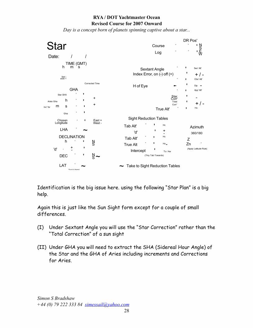
Identification is the big issue here. using the following “Star Plan” is a big help.
Again this is just like the Sun Sight form except for a couple of small differences.
(I) Under Sextant Angle you will use the “Star Correction” rather than the “Total Correction” of a sun sight
(II) Under GHA you will need to extract the SHA (Sidereal Hour Angle) of the Star and the GHA of Aries including increments and Corrections for Aries.
RYA / DOT Yachtmaster OceanRevised Course for 2007 Onward
Day is a concept born of planets spinning captive about a star...
Simon S Bradshaw +44 (0) 79 222 333 84 [email protected]
28
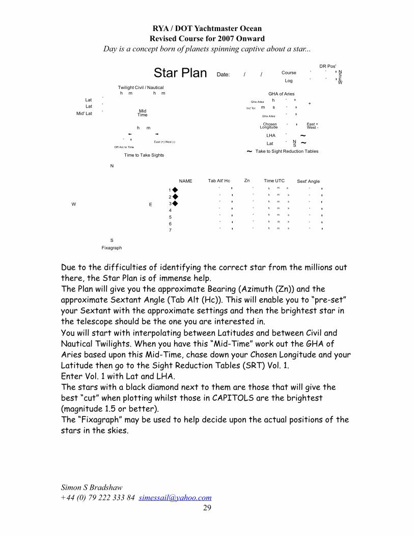
Due to the difficulties of identifying the correct star from the millions out there, the Star Plan is of immense help.The Plan will give you the approximate Bearing (Azimuth (Zn)) and the approximate Sextant Angle (Tab Alt (Hc)). This will enable you to “pre-set” your Sextant with the approximate settings and then the brightest star in the telescope should be the one you are interested in. You will start with interpolating between Latitudes and between Civil and Nautical Twilights. When you have this “Mid-Time” work out the GHA of Aries based upon this Mid-Time, chase down your Chosen Longitude and your Latitude then go to the Sight Reduction Tables (SRT) Vol. 1.Enter Vol. 1 with Lat and LHA.The stars with a black diamond next to them are those that will give the best “cut” when plotting whilst those in CAPITOLS are the brightest (magnitude 1.5 or better).The “Fixagraph” may be used to help decide upon the actual positions of the stars in the skies.
RYA / DOT Yachtmaster OceanRevised Course for 2007 Onward
Day is a concept born of planets spinning captive about a star...
Simon S Bradshaw +44 (0) 79 222 333 84 [email protected]
29
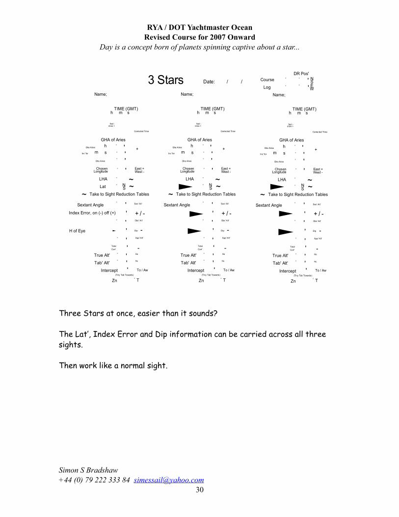
Three Stars at once, easier than it sounds?
The Lat’, Index Error and Dip information can be carried across all three sights.
Then work like a normal sight.
RYA / DOT Yachtmaster OceanRevised Course for 2007 Onward
Day is a concept born of planets spinning captive about a star...
Simon S Bradshaw +44 (0) 79 222 333 84 [email protected]
30
Passage PlanningThe Battle-plan fails when it meets the enemy - Von Clauswitz
Do not plan for failure - plan for success
Rousmaniere states that "taking seriously the possibility of emergencies requires the cautious state of mind known as forehandedness. A helpful rule of thumb, laid out by the U.S. Navy, is that safety requires eternal vigilance." Then Rousmaniere also sets out a “Formula for Disaster” to explain the repeated patterns of behaviour that appear over and over again in major boating emergencies or losses. Then he nicely articulates the following four rules to avoid such incidents
1. Prepare the Boat: Look at everything with a worst case state of mind.
2. Prepare the Crew: Assign responsibilities and make sure everybody understands how everything works and what to do if...
3. Choose a Safe Route: Avoid bad weather and seasons, make sure all charts etc., are on board, and have a fall back plan in case...
4. Prepare for Emergencies: Practice, practice, practice. If you can't do actual hands on practice, do mental practice.
Rousmaniere states that "taking seriously the possibility of emergencies requires the cautious state of mind known as forehandedness. A helpful rule of thumb, laid out by the U.S. Navy, is that safety requires eternal vigilance." Then Rousmaniere sets out a Formula For Disaster to explain the repeated patterns of behaviour that appear over and over again in major boating emergencies or losses.
The seven elements in the formula are:
1. A rushed, ill-considered departure--this occurs in virtually all bad accident, where scheduling rather than weather conditions dictates departure.
2. A dangerous route--the route selected has predictable hazards (reefs, currents, shoals, lee shores, commercial traffic, etc.)
3. There is no Plan B--there is nowhere to go if Plan A turns out not to be do-able.
RYA / DOT Yachtmaster OceanRevised Course for 2007 Onward
Day is a concept born of planets spinning captive about a star...
Simon S Bradshaw +44 (0) 79 222 333 84 [email protected]
31
4. The crew is unprepared--shorthanded and open to fatigue, under the influence, or hasn't practiced essential "what ifs".
5. The boat is unprepared--charts are missing, lights don't work, or equipment needs repair, etc.
6. The crew panics after injury--when someone is injured, the boat must still be taken care of.
7. Poor leadership--the captain is weak, ignorant, or macho and/or doesn't properly use the strengths of the remaining crew.
The other side of the formula for disaster, is the 4 Rules of Preparation The Four Rules of Preparation are set forth by John Rousmaniere in the essential book, The Annapolis Book of Sailing and Seamanship, 3rd Edition.
The MCA (in agreement with the IMO) state:
GUIDELINES FOR VOYAGE PLANNING(IMOResolution A.893(21)
Annex 25 of SOLAS V - GUIDELINES FOR VOYAGE PLANNING
1 Objectives
1.1 The development of a plan for voyage or passage, as well as the close and continuous monitoring of the vessel's progress and position during the execution of such a plan, are of essential importance for safety of life at sea, safety and efficiency of navigation and protection of the marine environment.
1.2 The need for voyage and passage planning applies to all vessels. There are several factors that may impede the safe navigation of all vessels and additional factors that may impede the navigation of large vessels or vessels carrying hazardous cargoes. These factors will need to be taken into account in the preparation of the plan and in the subsequent monitoring of the execution of the plan.
1.3 Voyage and passage planning includes appraisal, i.e. gathering all information relevant to the contemplated voyage or passage; detailed planning of the whole voyage or passage from berth to berth, including those areas necessitating the presence of a pilot; execution of the plan; and the monitoring of the progress of the vessel in the implementation of the plan. These components of voyage/passage planning are analysed below.
2 Appraisal
2.1 All information relevant to the contemplated voyage or passage should be considered. The following items should be taken into account in voyage and passage planning:
.1 the condition and state of the vessel, its stability, and its equipment; any operational limitations; its permissible draught at sea in fairways and in ports; its manoeuvring data, including any restrictions;
RYA / DOT Yachtmaster OceanRevised Course for 2007 Onward
Day is a concept born of planets spinning captive about a star...
Simon S Bradshaw +44 (0) 79 222 333 84 [email protected]
32
.2 any special characteristics of the cargo (especially if hazardous), and its distribution, stowage and securing on board the vessel;
.3 the provision of a competent and well-rested crew to undertake the voyage or passage;
.4 requirements for up-to-date certificates and documents concerning the vessel, its equipment, crew, passengers or cargo;
.5 appropriate scale, accurate and up-to-date charts to be used for the intended voyage or passage, as well as any relevant permanent or temporary notices to mariners and existing radio navigational warnings;
.6 accurate and up-to-date sailing directions, lists of lights and lists of radio aids to navigation; and
.7 any relevant up-to-date additional information, including:
.1 mariners' routing guides and passage planning charts, published by competent authorities;
.2 current and tidal atlases and tide tables;
.3 climatological, hydrographical, and oceanographic data as well as other appropriate meteorological information;
.4 availability of services for weather routing (such as that contained in Volume D of the World Meteorological Organisation's Publication No. 9);
.5 existing ships' routing and reporting systems, vessel traffic services, and marine environmental protection measures;
.6 volume of traffic likely to be encountered throughout the voyage or passage;
.7 if a pilot is to be used, information relating to pilotage and embarkation and disembarkation including the exchange of information between master and pilot;
.8 available port information, including information pertaining to the availability of shore-based emergency response arrangements and equipment; and
.9 any additional items pertinent to the type of the vessel or its cargo, the particular areas the vessel will traverse, and the type of voyage or passage to be undertaken.
2.2 On the basis of the above information, an overall appraisal of the intended voyage or passage should be made. This appraisal should provide a clear indication of all areas of danger; those areas where it will be possible to navigate safely, including any existing routing or reporting systems and vessel traffic services; and any areas where marine environmental protection considerations apply.
3 Planning
3.1 On the basis of the fullest possible appraisal, a detailed voyage or passage plan should be prepared which should cover the entire voyage or passage from berth to berth, including those areas where the services of a pilot will be used.
3.2 The detailed voyage or passage plan should include the following factors:
RYA / DOT Yachtmaster OceanRevised Course for 2007 Onward
Day is a concept born of planets spinning captive about a star...
Simon S Bradshaw +44 (0) 79 222 333 84 [email protected]
33
.1 the plotting of the intended route or track of the voyage or passage on appropriate scale charts: the true direction of the planned route or track should be indicated, as well as all areas of danger, existing ships' routing and reporting systems, vessel traffic services, and any areas where marine environmental protection considerations apply;
.2 the main elements to ensure safety of life at sea, safety and efficiency of navigation, and protection of the marine environment during the intended voyage or passage; such elements should include, but not be limited to:
.1 safe speed, having regard to the proximity of navigational hazards along the intended route or track, the manoeuvring characteristics of the vessel and its draught in relation to the available water depth;
.2 necessary speed alterations en route, e.g., where there may be limitations because of night passage, tidal restrictions, or allowance for the increase of draught due to squat and heel effect when turning;
.3 minimum clearance required under the keel in critical areas with restricted water depth;
.4 positions where a change in machinery status is required;
.5 course alteration points, taking into account the vessel's turning circle at the planned speed and any expected effect of tidal streams and currents;
.6 the method and frequency of position fixing, including primary and secondary options, and the indication of areas where accuracy of position fixing is critical and where maximum reliability must be obtained;
.7 use of ships' routing and reporting systems and vessel traffic services;
.8 considerations relating to the protection of the marine environment; and
.9 contingency plans for alternative action to place the vessel in deep water or proceed to a port of refuge or safe anchorage in the event of any emergency necessitating abandonment of the plan, taking into account existing shore-based emergency response arrangements and equipment and the nature of the cargo and of the emergency itself.
3.3 The details of the voyage or passage plan should be clearly marked and recorded, as appropriate, on charts and in a voyage plan notebook or computer disk.
3.4 Each voyage or passage plan as well as the details of the plan, should be approved by the ships' master prior to the commencement of the voyage or passage.
4 Execution
4.1 Having finalised the voyage or passage plan, as soon as time of departure and estimated time of arrival can be determined with reasonable accuracy, the voyage or passage should be executed in accordance with the plan or any changes made thereto.
4.2 Factors which should be taken into account when executing the plan, or deciding on any departure there from include:
.1 the reliability and condition of the vessel's navigational equipment;
RYA / DOT Yachtmaster OceanRevised Course for 2007 Onward
Day is a concept born of planets spinning captive about a star...
Simon S Bradshaw +44 (0) 79 222 333 84 [email protected]
34
.2 estimated times of arrival at critical points for tide heights and flow;
.3 meteorological conditions, (particularly in areas known to be affected by frequent periods of low visibility) as well as weather routing information;
.4 daytime versus night-time passing of danger points, and any effect this may have on position fixing accuracy; and
.5 traffic conditions, especially at navigational focal points.
4.3 It is important for the master to consider whether any particular circumstance, such as the forecast of restricted visibility in an area where position fixing by visual means at a critical point is an essential feature of the voyage or passage plan, introduces an unacceptable hazard to the safe conduct of the passage; and thus whether that section of the passage should be attempted under the conditions prevailing or likely to prevail. The master should also consider at which specific points of the voyage or passage there may be a need to utilise additional deck or engine room personnel.
5 Monitoring
5.1 The plan should be available at all times on the bridge to allow officers of the navigational watch immediate access and reference to the details of the plan.
5.2 The progress of the vessel in accordance with the voyage and passage plan should be closely and continuously monitored. Any changes made to the plan should be made consistent with these Guidelines and clearly marked and recorded.
RYA / DOT Yachtmaster OceanRevised Course for 2007 Onward
Day is a concept born of planets spinning captive about a star...
Simon S Bradshaw +44 (0) 79 222 333 84 [email protected]
35
RYA / DOT Yachtmaster OceanRevised Course for 2007 Onward
Day is a concept born of planets spinning captive about a star...
Simon S Bradshaw +44 (0) 79 222 333 84 [email protected]
36