r/v natsushima cruise report nt12-13 · the purpose of this research proposal is to understand the...
TRANSCRIPT

1
R/V Natsushima Cruise Report NT12-13
In-situ bio-CCS experiment by guest molecular replacement method with methane hydrate
Japan Sea
May 24 – June 5, 2012
Japan Agency for Marine-Earth Science and Technology (JAMSTEC)

2
Contents
Pages
1. Cruise Information 1
2. Researchers and crews 3
3. Cruise log 6
4. Observation
4.1 Research proposal #1 11
4.2 Research proposal #2 22
Notice on Using 27

1
1. Cruise Information
1.1 Cruise ID NT12-13
1.2 Ship Name R/V Natsushima
1.3 Title of the Cruise In-situ bio-CCS experiment by guest molecular replacement method with methane hydrate
1.4 Chief Scientist Hideaki Machiyama (JAMSTEC)
1.5 Title of the Proposal & Representative of the Science Party 1. Fumio Inagaki (JAMSTEC)
In-situ bio-CCS experiment by guest molecular replacement method with methane hydrate 2. Taiyo Kobayashi (JAMSTEC)
A comprehensive field test of a deep profiling float developed in Japan
1.6 Cruise Period May 24 – June 5, 2012
1.7 Ports of Call Naoetsu (Niigata Pref.) – Yokosuka (Kanagawa Pref.)
1.8 Research Area Japan Sea – western Joetsu Basin and off Yamagata – (Fig. 1)

2
Fig. 1 Index map of the research area and the dive points in the NT12-13 Cruise.

3
2. Researchers and crews
2.1 Chief scientist Hideaki MACHIYAMA JAMSTEC
2.2 Representative of the science party Proposal 1
Fumio INAGAKI JAMSTEC Proposal 2
Taiyo KOBAYASHI JAMSTEC
2.3 Science party Proposal 1
Hitoshi TOMARU* JAMSTEC / University of Tokyo Atsushi TANI* JAMSTEC / Osaka University Koichi IIJIMA* JAMSTEC Yoko OHTOMO* JAMSTEC Ryo MATSUMOTO* JAMSTEC / University of Tokyo Mineo HIROMATSU* University of Tokyo Hiroyuki OCHIAI* University of Tokyo Takeshi OI* University of Tokyo Fumio INAGAKI JAMSTEC Yojiro IKEGAWA JAMSTEC / Central Research Institute of Electric Power
Industry Yuki MORONO JAMSTEC Akira IJIRI JAMSTEC Fujio YAMAMOTO JAMSTEC Goichiro URAMOTO JAMSTEC
*Onboard scientists
Proposal 2 Taiyo KOBAYASHI* JAMSTEC Kenichi AMAIKE* JAMSTEC / Tsurumi-Seiki Co. Ltd Kazuhiro WATANABE* JAMSTEC / Tsurumi-Seiki Co. Ltd Tetsuro INO* JAMSTEC / Tsurumi-Seiki Co. Ltd Ken KAWANO JAMSTEC Toshio SUGA JAMSTEC Kenichi ASAKAWA JAMSTEC Tadahiro HYAKUDOME JAMSTEC Mitsuhiro TAKAKUSAKI Tsurumi-Seiki Co. Ltd Jain SUSHEEL Tsurumi-Seiki Co. Ltd
*Onboard scientists
4
2.4 Marine Technician Satomi MINAMIZAWA Nippon Marine Enterprises, LTD.
2.5 R/V NATSUSHIMA Officers and Crew Captain Hitoshi Tanaka Chief Officer Naoto Kimura 2nd Officer Isao Maeda 3rd Officer Motoi Katsumata Chief Engineer Minoru Tsukada 1st Engineer Kimio Matsukawa 2nd Engineer Takahiro Mori 3rd Engineer Hozumi Kuratomi Junior 3rd Engineer Naoomi Uemura Chief Electronic Operator Tokinori Nasu 2nd Electronic Operator Yoichi Inoue 3rd Electronic Operator Ryosuke Komatu Boat Swain Tadahiko Toguchi Able Seaman Yasuo Konno Able Seaman Nobuyuki Ichikawa Able Seaman Yoshiaki Matsuo Able Seaman Hiroaki Murase Sailor Kazuho Ikeda Sailor Yasunobu Kawabe Sailor Yusaku Kanada No.1 Oiler Kiyoshi Yahata Oiler Katsuyuki Yoshida Oiler Ryota Suzuki Assistant Oiler Ryo Sato Assistant Oiler Taijyun Iwao Assistant Oiler Aoi Takamiya Chief Steward Teruyuki Yoshikawa Steward Shinsuke Tanaka Steward Koji Kirita Steward Hiroyuki Ohba Steward Tatsuya Yamamoto
2.6 ROV Hyper-Dolphin operation team Submersible Operation Manager Yoshinari Ono 1st Submersible Technical Officer Homare Wakamatu 2nd Submersible Technical Officer Katsushi Chiba 2nd Submersible Technical Officer Yosuke Chida

5
2nd Submersible Technical Officer Teppei Kido 2nd Submersible Technical Officer Yudai Sakakibara 2nd Submersible Technical Officer Ryo Saigo

6
3. Cruise log
Date Local Time (UTC+9h)
Note Description Position/Weather/Wind/Sea condition
May 24
08:00 09:00 11:00
09:30-10:00
13:00-14:00
15:00-15:30
Sail out, proceeding to research area boarded let go all shore line, left NAOETSU arrived at research area carried out onboard education & training for scientists practiced boat, fire and collision drills scientific meeting
Joetsu Basin
05/24 12:00 37-30.9N, 137-59.0E Joetsu Basin Fine but cloudy ESE-1 (Light air) 1(Sea calm) 1(Low swell shot) Visibly: 5'
May 25
08:04
08:21 08:50
14:30 14:51
16:19-18:19
18:00
Deployed Deep-float released XBT @ 37-37.0988N,139-54.9383E launched Deep-float calibrated Deep-float location by GPS refloated Deep-float commenced proceeding to MBES point carried out MBES mapping survey scientific meeting
@37-37.1663N, 137-55.4961E
05/25 12:00 37-36.6N, 137-58.3E Joetsu Basin Overcast NW-4 (Moderate breeze) 2 (Sea smooth) 1 (Low swell shot) Visibly: 7'
May 26
07:15 08:08 08:12 08:23 08:58 16:13 16:39 16:52
17:42-19:13 18:00-18:10
ROV Hyper Dolphin dive 1386 arrived at dive point hoisted up HPD launched HPD started HPD#1386 dive operation landed at sea bottom left bottom refloated HPD recovered carried out MBES mapping survey scientific meeting
Middle part of Umitaka Spur Depth: 895m Depth: 881m
05/26 12:00 (UTC+9h) 37-26.1N,138-00.4E Joetsu Basin Fine but cloudy South-1 (Light air) 1 (Calm) 1 (Low swell shot) Visibly: 6'

7
May 27
07:15 08:08 08:11 08:24 09:08 16:16 16:44 16:59
18:00-18:10
ROV Hyper Dolphin dive 1387 arrived at dive point hoisted up HPD launched HPD started HPD#1387 dive operation landed at sea bottom left bottom refloated HPD recovered scientific meeting
Middle part of Joetsu Knoll Depth: 1009m Depth: 983m
05/27 12:00 (UTC+9h) 37-34.3N,137-57.9E Joetsu Basin Fine but cloudy ENE-4 (Moderate breeze) 2 (Sea smooth) 1 (Low swell shot) Visibly: 6'
May 28
07:40 08:05 08:09 08:22 08:54 11:01 11:28 11:44 13:08 13:12 13:23 13:57 16:22 16:51 17:05
18:05-18:15
ROV Hyper Dolphin dive 1388 and 1389 arrived at dive point hoisted up HPD launched HPD started HPD#1388 dive operation landed at sea bottom left bottom refloated HPD recovered hoisted up HPD launched HPD started HPD#1389 dive operation landed at sea bottom left bottom refloated HPD recovered scientific meeting
Northern Umitaka Spur Depth: 915m Depth: 913m Southern Joetsu Knoll Depth: 978m Depth: 976m
05/28 12:00 (UTC+9h) 37-26.8N,138-01.0E Joetsu Basin Overcast SSE-5 (Fresh breeze) 3 (Sea slight) 1(Low swell shot) Visibly: 6'

8
May 29
07:40 08:06 08:15 08:26 08:59 11:32 12:00 12:12 13:38 13:42 13:53 14:29 16:15 16:43 16:56
18:05-18:15
ROV Hyper Dolphin dive 1390 and 1391 arrived at dive point hoisted up HPD launched HPD started HPD#1390 dive operation landed at sea bottom left bottom refloated HPD recovered hoisted up HPD launched HPD started HPD#1391 dive operation landed at sea bottom left bottom refloated HPD recovered scientific meeting
Southern Joetsu Knoll Depth: 977m Depth: 975m Southern Joetsu Knoll Depth: 977m Depth: 976m
05/29 12:00 (UTC+9h) 37-32.4N,137-56.3E Joetsu Basin Cloudy North-3 (Gentle breeze) 2 (Sea smooth) 2 (Low swell long) Visibly: 7'
May 30
07:37
08:43-10:21 10:21
Recovered Deep-float recovered Deep-float carried out MBES mapping survey commenced proceeding to SAKATA
05/30 12:00 (UTC+9h) 37-36.6N,138-28.0E Off Kashiwazaki Fine but cloudy NNE-3 (Gentle breeze) 3 (Sea slight) 2 (Low swell long) Visibly: 7'

9
May 31
07:00 07:25
07:30
08:30-09:00
09:20 09:29
09:54
MBES mapping survey arrived at SAKATA 4 scientist embarked and 8 scientist disembarked commenced proceeding to research area carried out onboard education & training for scientists arrived at research area released XBT @ 38-53.8729N,139-18.6747E commenced MBES mapping survey at Area 1
Off YAMAGATA
05/31 12:00 (UTC+9h) 39-05.2N,139-15.3E Off YAMAGATA Fine but cloudy NNE-3 (Gentle breeze) 2(Sea smooth) 2 (Low swell long) Visibly: 7'
June 1
11:24
12:21-18:51
19:06
MBES mapping survey finished MBES mapping survey at Area 1 and proceeding to Area 2 carried out MBES mapping survey at Area 2 commenced MBES mapping survey at Area 4
06/01 12:00 (UTC+9h) 38-51.6N,139-15.2E Off YAMAGATA Overcast North-2 (Light breeze) 2 (Sea smooth) 2 (Low swell long) Visibly: 6'
June 2
02:44
04:43-10:23
10:25
MBES mapping survey and Transit to JAMSTEC finished MBES mapping survey at Area 4 and proceeding to Area 3 carried out MBES mapping survey at Area 3 left research area and commenced proceeding to JAMSTEC
06/02 12:00 (UTC+9h) 39-27.6N,139-23.0E Off Tobi-shima Fine but cloudy North-3(Gentle breeze) 2 (Sea smooth) 2 (Low swell long) Visibly: 7'

10
June 3
Transit to JAMSTEC
06/03 12:00 (UTC+9h) 39-55.2N,142-03.3E Off Miyako Overcast SSE-3 (Gentle breeze) 3 (Sea slight) 3 (Moderate short) Visibly: 6'
June 4 18:00
Transit to JAMSTEC scientific meeting
06/04 12:00 (UTC+9h) 36-01.3N,141-04.4E Off Inubosaki Fog SSE-3 (Gentle breeze) 2 (Sea smooth) 4 (Moderate average) Visibly: 1'
June 5
09:00 10:00
Arrived at YOKOSUKA arrived at YOKOSUKA disembarked from NATSUSHIMA finished NT12-13 cruise

11
4. Observation 4.1 Research proposal #1
1) Background and objectives Joetsu Gas Hydrate Field of the western Joetsu Basin in the eastern margin of the Japan
Sea is one of the best fields for gas hydrate studies. There are many methane plumes and active methane seeps associated with gas hydrate blocks in the several mounds on the Umitaka Spur and Joetsu Knoll.
The purpose of this research proposal is 1) to understand the occurrence of methane hydrate on sea-floor, 2) to select the best location for in-situ bio-CCS experiment that use a newly-developed heat-zonde CO2 injection system to tackle the issue of CO2 sequestration in the deep-sea and sub-seafloor environments, and 3) to obtain the bathymetric data off Yamagata for a methane hydrate study. 2) Observation summary
We conducted two ROV diving surveys around the hydrate mounds on the Umitaka Spur (#1386 & 1388) and four diving surveys on the Joetsu Knoll (#1387, #1389 ~ 1391) (Fig. 2). Three candidate locations for in-situ bio-CCS experiment were selected in this survey area. We recovered a water temperature data logger deployed in NT10-10 Leg2 Cruise, and sampled many sediment cores, two pressure-keeping cores, authigenic carbonate rocks, and many benthos. We also obtained the bathymetric data off Yamagata area. 3) Dive information: payloads

12
Figure 2 ROV diving survey points in the research area

13

14

15

16
4) Dive inform
ation: dive track D
ive #1386

17
Dive #1387

18
Dive #1388

19
Dive #1389

20
Dive #1390

21
Dive #1391

22
4.2 Research proposal #2 1) Backgrounds and purposes in the field test
The ocean plays an important role in the global climate due to its huge capacity of heat and only a little change of its temperature affects the climate largely. Thus, the ocean observation is very important in order to monitor the present status of the ocean and also to predict the future climate. Recently some studies reported that variations in deep layers in the Labrador Sea, a major region of deep water formation, were almost the same level as in the surface layers. Also the deep and bottom waters in the Pacific and Indian Oceans were verified to have warmed significantly during 1990s to 2000s. The heat accumulated in the global ocean deeper layers than 3000 m was estimated at about 1.3×10²² J for 15 years from the 1990s to the 2000s and the warming resulted in the rise of sea level by about 0.1 mm yr-1. The estimations, however, have larger errors than those for the other components of the global climate because of sparse observations. Thus, the deep ocean is a component not to be ignored and also a major source of uncertainness in the global climate.
Understanding the anthropogenic global change and predicting its future are important issues in the international community now. Thus, importance of the deep ocean monitoring becomes increasingly recognized from the viewpoints of the social security, too. Thus, an advancement of systematic deep ocean observations was thus approved at OceanObs’09 held in 2009 as an international guideline of observational ocean sciences for the next decade (2010–2019). An observing array by numerous deep profiling floats was an essential component in the system to monitor temperature and salinity in the deep ocean and to estimate the sea surface rise accurately.
The development of the network, however, was not set to start yet, because the maximum observation depth is up to 2000 m for the current types of floats. Thus, some of float makers are now developing deep floats. In Japan, JAMSTEC and Tsurumi-Seiki Co. Ltd (TSK) have developed a new deep profiling float since 2009 and the first prototype of the deep float was assembled in 2011 (Fig. 3).
Control of the float operation in water is one of the most important factors for profiling floats. We have verified that its control soft-ware worked well at on-desk simulations. Also, we had examined its function in coastal waters some times. However, the verifications by such methods were very limited. Situations of the float in water are more complicated than those in the simulations. At the tests in coastal waters the deep float was tied to a fishing line connected to a surface drifting buoy, which hampered the deep float from moving freely in water. The periods of the field tests are also allowed daytime of a day, which is very short considering very slow vertical movements (<10 cm s-1) of the float in water to ascend from and descend to the great depths (more than 500m).
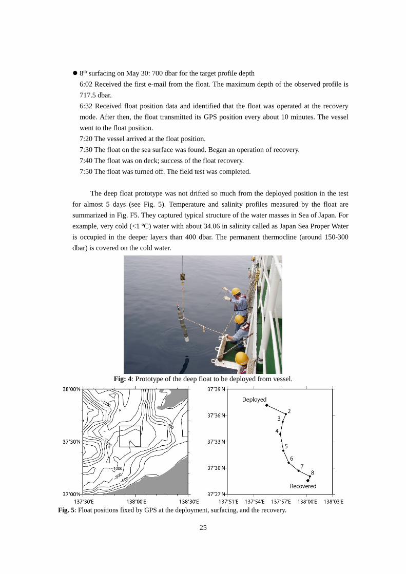
In the cruise we carried out a comprehensive field test of the deep float and the float was tied to nothing to examine the function of its control system under an ideal situation. The period of the test was much longer (about 5 days) than the previous field tests and the float conducted 8 cycles of a preset observation sequence.

23
Fig. 3: A prototype of the deep profiling floats
2) Details of the field test A prototype of the deep profiling float was deployed from the ship and then it operated
repeatedly preset sequence of observation cycles including descend, drift at a preset depth, ascend, observation by CTD, GPS positioning and data transition at the sea surface. At the end of the test the prototype was drifted on the sea surface and then recovered.
Main parameters of the test are follows: Period of the observation cycle: 18 hours Drifting depth: 400 dbar Profile depth: 800 dbar at odd cycle and 700 dbar at even cycle
3) Results of the field tests Summary
The results of the field test clarified that the control system of the deep float worked as well as it was expected before. The field test is the first time in which the deep float can move freely in water because of no tied line connecting a surface buoy and it is clarified that the float is apt to descent to deeper depth than the target depth very much (see Fig. 6). Thus, some parameters should be examined again and adjusted. After the adjustment, we expected that the deep float can be examined in deep water.
Details of the test Deployed on May 25
8:15 Float was switched on.

24
8:20 Float was deployed from the vessel (see Fig. 4). (8:30 Float waked up.) 8:50 Received messages (e-mails) from the float. 9:23 Identified that the float dived to depth (disappeared at the sea surface).
1st surfacing on May 25: 800 dbar for the target profiling depth 14:30 Received the first e-mail from the float, which meant that the float arrived at the sea surface. The maximum depth of the observed profile is 965.8 dbar. No position data of the float are included; the float failed GPS position fixing at sea surface.
2nd surfacing on May 26: 700 dbar for the target profile depth 6:23 Received the first e-mail from the float. The maximum depth of the observed profile is 795.8 dbar. The float succeeded to fix its position. After then, it never failed GPS positioning during the field test.
3rd surfacing on May 27: 800 dbar for the target profiling depth 0:50 Received the first e-mail from the float. The maximum depth of the observed profile is 870.7 dbar. The e-mails were received actually around 6 o’clock because no data transmission between the vessel and JAMSTEC mail server from 22 to 6 o’clock.
4th surfacing on May 27: 700 dbar for the target profile depth 18:24 Received the first e-mail from the float. The maximum depth of the observed profile is 732.8 dbar. After then we sent an e-mail command to the float via TSK office that it omits parking drift and ascends from 800 dbar at the next cycle. The command will arrive at the float at the next (5th) surfacing and be done at the 6th cycle. Since the time of float surfacing on the day of float recovery (May 30) was shifted from midnight to morning.
5th surfacing on May 28: 800 dbar for the target profiling depth 13:27 Received the first e-mail from the float. The maximum depth of the observed profile is 810.2 dbar.
6th surfacing on May 28: 800 dbar for the target profile depth 19:43 Received the first e-mail from the float. The maximum depth of the observed profile is 837.3 dbar. The float arrived at the sea surface at the expected time; control of the float by e-mail commands was succeeded.
7th surfacing on May 29: 800 dbar for the target profiling depth 12:20 Received the first e-mail from the float. The maximum depth of the observed profile is 812.7 dbar. After then we sent an e-mail command to the float via TSK office that the float operation mode is changed to the recovery mode at the next cycle. At the recovery mode, the float drifts on the sea surface and transmits its GPS position every about 10 minutes.
25
8th surfacing on May 30: 700 dbar for the target profile depth 6:02 Received the first e-mail from the float. The maximum depth of the observed profile is 717.5 dbar. 6:32 Received float position data and identified that the float was operated at the recovery mode. After then, the float transmitted its GPS position every about 10 minutes. The vessel went to the float position. 7:20 The vessel arrived at the float position. 7:30 The float on the sea surface was found. Began an operation of recovery. 7:40 The float was on deck; success of the float recovery. 7:50 The float was turned off. The field test was completed.
The deep float prototype was not drifted so much from the deployed position in the test
for almost 5 days (see Fig. 5). Temperature and salinity profiles measured by the float are summarized in Fig. F5. They captured typical structure of the water masses in Sea of Japan. For example, very cold (<1 ºC) water with about 34.06 in salinity called as Japan Sea Proper Water is occupied in the deeper layers than 400 dbar. The permanent thermocline (around 150-300 dbar) is covered on the cold water.
Fig: 4: Prototype of the deep float to be deployed from vessel. Fig. 5: Float positions fixed by GPS at the deployment, surfacing, and the recovery.

26
Fig. 6: Vertical movement of the deep float in water during the test. The target depth of each cycle is shown by red arrow. Fig. 7: Temperature (left) and salinity (right) profiles obtained by the float during the test. The number at the tail of each profile represents the number of the float cycle. Each profile is shifted by 1K in temperature and 0.1 in salinity.

27
Notice on Using
This cruise report is a preliminary documentation as of the end of the cruise. This report may not be corrected even if changes on contents (i.e. taxonomic classifications) may be found after its publication. This report may also be changed without notice. Data on this cruise report may be raw or unprocessed. If you are going to use or refer to the data written on this report, please ask the Chief Scientist for latest information. Users of data or results on this cruise report are requested to submit their results to the Data Management Group of JAMSTEC.