rural walking in massachusetts: a tool kit for municipalities
TRANSCRIPT

Rural Walking in MassachusettsA Tool Kit for Municipalities
A WalkBoston report
Prepared for The Massachusetts Department of Public HealthMarch 2013


Introduction
1. Background1.1. A long history of rural walking in Massachusetts1.2. The present rural areas of Massachusetts
1.3. Resident perceptions of rural character
2. Rural Walking Design Choices2.1. Sidewalk with curb2.2. Roadside path2.3. Meandering roadside path2.4. Local and regional recreational trails2.5. Regional trail for multiple users 2.6. Road shoulder for hiking and biking 2.7. Traffic calming and vehicle speeds2.8. Standards of design used by case study towns2.9. Potential users of walkways2.10. ADA requirements
3. Findings3.1. Increased walking has the potential to bring significant benefits to rural and semi-rural communities.3.2. Walking infrastructure is needed in rural and semi-rural communities.3.3. Building walkways takes time and creativity.3.4. There are significant challenges to creating rural walking infrastructure.3.5. Walkway destinations are important3.6. Safe walking access to schools is essential.3.7. The design of a walkway should respond to existing conditions and intended uses.3.8. Traffic calming measures may improve safety and be cost-effective.3.9. Transparent, inclusive, and collaborative planning processes help towns implement walking routes.3.10. Pedestrians and drivers need basic information about walking.
4. Case Studies4.1. Amherst4.2. Ashfield4.3. Barnstable4.4. Barre4.5. Bolton4.6. Boxborough4.7. Dudley4.8. Hadley4.9. Lenox4.10. Lincoln4.11. Mashpee4.12. Norwell4.13. Salisbury
Table of Contents
Acknowledgments
Towns
Amherst: Jonathan Tucker, Planning Director; Janet Ryan, Librarian; Elizabeth Wroblicka Esq.Ashfield: Harry Dodson, Dodson & Flinker; Lester Garvin; Rich Hubbard - Franklin Land Trust, Phil Pless; Susan Todd. Barre: Paul Cranston, Chair, Barre Common Oversight Committee; Keith Hamilton, consultantBarnstable: Barnstable Town Councilor Ann Canedy; Assistant Town Manager Mark Ells; Town of Barnstable Department of Public Works – Roger Parsons, Town Engineer and Michael Perry, Chief, Highway DivisionBolton: Mary Ciummo, Chair, Public Ways Safety Subcommittee to develop a Mobility Plan; Jennifer Burney, Town Planner; Tom Doolittle, landscape architect; Don Kindsvatter, urban designerBoxborough:Elizabeth Hughes, Town Planner; Tom Garmon, Director of Public WorksDudley: Nancy Runkle, Town PlannerHadley: William Dwyer, Town Planner, Kristin DeBoer, Kestrel TrustLenox: Gregory Federspiel, Town Manager; Mary Albertson, Town PlannerLincoln: Tom Gumbert , Town Planner; William “Buzz” Constable, Lincoln Land Conservation TrustMashpee: Tom Fudala, Town Planner; Kathryn Laurent, Director of Public WorksNorwell: Chris Deiiorio, Town PlannerSalisbury:Lisa Pearson, Town Planner
Regional Planning Agencies
Berkshire Regional Planning Commission Mackenzie Greer; Klete Kus Central Massachusetts Regional Planning CommissionMary Ellen Blunt; Jonathan ChurchCape Cod Commission Martha Heavener; Glen Cannon Franklin Regional Council of Governments Maureen Mullaney, Beth Giannini;Merrimack Valley Planning CommissionAntony Komornick Metropolitan Area Planning CouncilDavid Loutzenheiser Montachusett Regional Planning CommissionBrad Harris Northern Middlesex Council of GovernmentsJustin Howard Old Colony Planning CouncilWilliam McNultyPioneer Valley Planning CommissionRana al-Jammel Southeastern Regional Planning and Economic Development DistrictJim Hadfield
State Agencies
Massachusetts Department of Conservation and RecreationIrene del Bono, Melissa Cryon Massachusetts School Building Authority Diane SullivanMassachusetts Highway DepartmentLou Rabito, Bicycle/Pedestrian Accommodation Engineer; Jocelyn DeWire, Supervisor, Dudley Project; Shapar Negah, Supervisor, Barre Project; Bill Travers, Supervisor, Barnstable Route 6A projectCenter for Rural Massachusetts at the University of Massachussetts – Amherst
Authors: Robert Sloane and Wendy LandmanContributing Editor: Sara Brown

1
Introduction
Massachusetts is a relatively urbanized state, and its eastern half is the northern anchor of the Boston-Washington megalopolis. However, as defined by the US Census Bureau , over half of the Commonwealth’s 351 cities and towns are wholly or partially rural. In addition, many communities with densely built-up centers have rural edges, and many municipalities work hard to retain the rural appearance of tree-lined roads and open fields that so many residents find attractive.
Outside of town centers, low-density communities often provide little infrastructure for walkers. Paths or sidewalks are few and far between, and interconnected networks of walkways are rare. People have little incentive to walk because they may have no choice but to travel along the edge of roads, where fast-moving vehicles pose dangers to both adults and children. In addition, the lack of crosswalks across relatively high-speed roadways can make it difficult for walkers to safely get around their communities on foot.
With walking recognized as an essential ingredient of healthy living, many residents of rural and low-density suburban areas are now looking for ways to create safer walking opportunities in their communities. Walking, as an easy and inexpensive form of regular physical activity, helps lower the risks of cancer, heart disease, diabetes, stroke, arthritis, and osteoporosis, as well as keep weight in check and ward off depression. Walking is most effective if each person gets a minimum of 30 minutes of daily activity, according to the U.S. Centers for Disease Control.
Recently, several rural communities approached WalkBoston, Massachusetts’ primary pedestrian advocacy organization, for advice about steps they could take to provide better walking conditions. Simultaneously, the MA Department of Public Health (DPH) began working with a diverse set of 52 Massachusetts communities to help them promote greater physical activity among their residents
through the Mass in Motion and Community Transformation Grant programs. DPH commissioned WalkBoston, as a provider of technical assistance to these programs, to develop tools to help rural and low-density suburban communities initiate policies and projects to increase opportunities for walking. These tools have been assembled based on work already underway in rural and semi-rural towns in Massachusetts.
This report provides an introduction to different types of walking facilities that can be constructed in rural areas. It includes case studies of a number of communities building creative and cost-effective walking facilities. These communities have faced many challenges in the process of planning and constructing their walking facilities. Although each community is unique, these case study examples may help other communities identify opportunities to provide better walking infrastructure and the tools to implement such improvements.
WalkBoston is grateful to the many Massachusetts residents, municipal staff, and state and regional agencies who contributed to this report.

2
1. Background
1.1. The long history of rural walking in Massachusetts
For about two hundred years after Massachusetts was first settled, residents relied on walking as their principal mode of transportation. Horses were expensive and not available to everyone. As a result, walking exerted a powerful influence on town form. For early settlers, the church was the focus of community life, with attendance required by the colony’s religious leaders. Since walking was the basic means to get to town activities, churches had to be located within walking distance of homes. The unwritten standard was that a three-mile walk was the maximum that anyone should be required to travel to church. As a result, many towns in Massachusetts are approximately six miles across, with the church at the town center, and most of the town contained within a three-mile walking distance from the center in all directions.
In addition to church, early settlers walked to many other destinations in the community. Most traveled by foot to trade with neighbors, exchanging produce for specialty items such as fruits or candles. They had to walk to a site with waterpower where the miller could grind wheat or other grains into flour. Because Massachusetts is fortunate to have
The 3-mile walk to a town center expressed as 6-mile diameters superimposed on selected Massachusetts towns.
many small streams that could be dammed for waterpower, most towns had a mill within walking distance of residents. Residents also traveled to the blacksmith, who produced farming and logging tools, nails, hinges, lighting fixtures, horseshoes, and other metal items. Finally, to obtain supplies not made locally, residents walked to shops that were centrally located, usually at roadway intersections. Here they could find imported from abroad, because cloth was produced in the colonies in only limited quantities for nearly two centuries after settlement.
Residents’ walking needs led communities to establish paths between residences and the town center, where the church and school were located, as well as to millers, smiths and retailers. These paths became major roads and streets, used not only for walking, but also for horseback trips and later for horse-drawn carriages. Horses were generally compatible with walkers, because they trotted slowly (about 8 mph) and they could be heard from some distance, providing a warning to walkers. For protection from mud, communities hardened these paths with wood planks, stones, or gravel. Ultimately, the paths became roads, which were widened to accommodate automobiles. With the rise of cars, walking to destinations as part of daily life became largely unnecessary.
Eventually, people in rural and low-density suburban communities began to feel the need for exercise and for access to undeveloped open spaces. Parks and conservation areas were created, and walking was repositioned as a recreational activity - namely, hiking, an irregular versus a daily activity.
The decline in daily walking was especially apparent in low-density areas, where distances between destinations tend to be fairly substantial and walking cannot compete with the time saved by using a car. With a reduced need for everyday walking facilities, many municipalities avoided the expense of constructing sidewalks. The resulting lack of sidewalks further discouraged walking and contributed to the increased use of vehicles.

3
1.2. The present rural areas of Massachusetts
At a glance, Massachusetts, a small state with a large population, can appear to be totally urbanized. It is the third most densely populated state in the U.S., with an average of about 840 people per square mile. However, this density is very unevenly distributed across the state, with densities ranging from 5.8 people per square mile in the sparsely populated community of Mt. Washington to 18,404 people per square mile in the dense city of Somerville. Most of the densely populated areas in Massachusetts lie in the Greater Boston area and around Springfield and Worcester.
The Census Bureau bases its definition of “rural” on a combination of population density, total population size, and proximity to cities. In general, “rural” is a term to classify areas with small total populations or population density less than 1,000 people per square mile. Using a more refined analysis of settlement patterns than that based on census tracts, the Center for Rural Massachusetts at
Massachusetts Population Density Map
the University of Massachusetts/Amherst found that the most simple and precise indicator of “rurality” seems to be population density per square mile. Under this definition, densities of less than 500 persons per square mile are considered “rural.” By this measure, 190 of the 351 towns in Massachusetts are rural, with 16 percent of Massachusetts residents, 940,000 people, living in them. These rural communities occupy about 65 percent of the land area of the Commonwealth. In addition, within the more urbanized portions of the state, the Center for Rural Massachusetts has identified several “islands” of rural character, including:
• The North Shore from Salisbury to Essex to Boxford
• The South Shore in a triangular area between Plymouth, Taunton, Fall River and New Bedford
• Almost all communities on Cape Cod
• Carlisle, Dover, Hopkinton, Norwell and Sherborn within the Boston metropolitan area.
Source: U.S Census Bureau, Census 2010 Summary File 1, populaiton by census tract

4
1.3. Resident perception of rural character
The official definitions of “rural” can be modified by the perceptions of local residents, who may view their low-density communities as rural. In some communities, this attitude translates into local support for slow or limited development and residents who hold strict views of what kind of development is in keeping with their town’s rural appearance. Community surveys frequently include questions about local preferences, why residents moved to their towns and what they like about their towns’ ambience. Significant numbers of residents responded that rural character was extremely important.
In some towns, residents’ attitudes about maintaining a rural character has impacted the types of walking infrastructure provided. Sometimes sidewalks - referring here to paved walkways protected by a curb from moving traffic - are seen as a harbinger of “urban” development, and are unpopular or opposed.
Winter Scene, 1934 by Martha Levy, Smithsonian Museum of American Art
Thus, to accommodate walking, some communities have sought unobtrusive methods of constructing walkways. One approach has been to build hiking trails, which have been accepted for many years as a source of recreational walking opportunities. Trails are usually laid out in loop that allows walkers to begin and end at a parking lot, and many towns have found it difficult to connect their individual trails into a comprehensive, town-wide system of walking facilities. Other communities have chosen to construct paved walkways parallel to roadways, yet separated from the pavement by a modest strip of land that does not include a curb. These “roadside paths” can be visually unobtrusive, and are relatively easy to incorporate into existing landscapes without disturbing the rural appearance of the town.
As municipalities consider ways in which they can add new walking facilities, it is important that they be attentive to many residents’ strong desire to retain the rural appearance of their communities. In rural or low-density areas around the state, trails and roadside paths may be the most appropriate methods of providing new walkways.

5
2. Rural walking design choices
2.1. Sidewalk with curb
The most common type of walkway in rural or low-density areas is the sidewalk. All of the case study communities have sidewalks, primarily in their town centers. Sidewalks are typically constructed of concrete, and provide a hard, smooth surface for walkers. Newer sidewalks are usually at least 4 - 8 feet wide to accommodate signage and street furniture, allow two people to pass comfortably or to walk side-by-side, accommodate disabled passage, and provide some separation from passing vehicles.
Traditional sidewalks usually have a curb placed between the walkway and vehicle lanes. When a curb of at least 6” in height is located adjacent to the roadway, it provides a vertical separation from vehicular traffic. In a rural context, curbed sidewalks are probably most useful for links that involve
In recognizing the need for safe walking facilities and programs for residents of all ages, rural and semi-rural communities in Massachusetts have used many strategies to construct new walkways. In many instances, these communities have come up with solutions which are quite distinct from urban communities where walkways tend to be more prevalent and are considered essential. The possibilities are summarized below:
Curbed sidewalk on both sides of the street
relatively short distance, such as connections between destinations in town centers or village cores. Examples of sidewalks abound in older town centers in the Commonwealth, including the case study communities.
However, there are difficulties associated with curbed sidewalks in rural and low-density communities. Sidewalks constructed some time ago may not be as wide as needed, and can seem hazardous to pedestrians, who feel too close to adjacent vehicle traffic flows. Sidewalk curbs are also accompanied by drainage issues and can require an underground pipe network to lead water away from paved surfaces. In addition, during the winter, narrow sidewalks that are close to the road can become covered with plowed snow from the roadway, limiting walkers’ use.
6
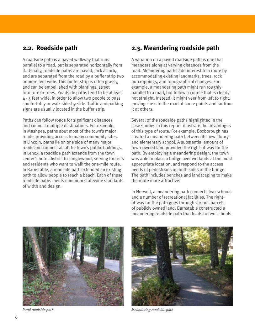
2.3. Meandering roadside path A variation on a paved roadside path is one that meanders along at varying distances from the road. Meandering paths add interest to a route by accommodating existing landmarks, trees, rock outcroppings, and topographical changes. For example, a meandering path might run roughly parallel to a road, but follow a course that is clearly not straight. Instead, it might veer from left to right, moving close to the road at some points and far from it at others.
Several of the roadside paths highlighted in the case studies in this report illustrate the advantages of this type of route. For example, Boxborough has created a meandering path between its new library and elementary school. A substantial amount of town-owned land provided the right-of-way for the path. By employing a meandering design, the town was able to place a bridge over wetlands at the most appropriate location, and respond to the access needs of pedestrians on both sides of the bridge. The path includes benches and landscaping to make the route more attractive.
In Norwell, a meandering path connects two schools and a number of recreational facilities. The right-of-way for the path goes through various parcels of publicly owned land. Barnstable constructed a meandering roadside path that leads to two schools
2.2. Roadside path
A roadside path is a paved walkway that runs parallel to a road, but is separated horizontally from it. Usually, roadside paths are paved, lack a curb, and are separated from the road by a buffer strip two or more feet wide. This buffer strip is often grassy, and can be embellished with plantings, street furniture or trees. Roadside paths tend to be at least 4 - 5 feet wide, in order to allow two people to pass comfortably or walk side-by-side. Traffic and parking signs are usually located in the buffer strip.
Paths can follow roads for significant distances and connect multiple destinations. For example, in Mashpee, paths abut most of the town’s major roads, providing access to many community sites. In Lincoln, paths lie on one side of many major roads and connect all of the town’s public buildings. In Lenox, a roadside path extends from the town center’s hotel district to Tanglewood, serving tourists and residents who want to walk the one-mile route. In Barnstable, a roadside path extended an existing path to allow people to reach a beach. Each of these roadside paths meets minimum statewide standards of width and design.
Rural roadside path Meandering roadside path

7
on one of the town’s major roadways. The walkway followed the hilly topography, avoiding the use of landfill to bring it to the level of the road. The walkway is also sufficiently wide to accommodate children traveling to school by bike. Because the School Department owned the land where the right-of-way for the new route lies, town engineers and planners were able to create an imaginative design that is appealing to kids.
2.4. Local trails (hiking)
Local hiking trails are usually constructed on land that is in public ownership or covered by agreements with private parties. These trails tend not to be paved and are usually left rustic. Frequently, they are not level, climbing up and around natural features to add interest to the trek. Since these trails are not required to meet ADA standards, they can be more steep and as narrow as 1.5 - 2 feet wide. Local trails sometimes provide access to specific destinations, such as schools or recreation centers. Trails may follow the general alignment of nearby roads, or diverge to enable more direct connections. Recreational trails run through conservation areas in Ashfield, Lincoln, Bolton, Boxborough, Barnstable, and Amherst. In Hadley, trails have been constructed along a riverside levee and through agricultural land.Lincoln has developed a town-wide system that
Local hiking trail
integrates roadside paths and hiking trails for access to schools and other destinations.
2.5. Regional trails (hiking)
Regional trails for hiking are less common than some other types of walkways. Significant long-distance hiking trails exist in Massachusetts, including the Appalachian Trail (95 miles in Massachusetts), the Midstate Trail (95 miles in Massachusetts), the Metacomet-Monadnock Trail (114 miles in Massachusetts), and the Bay Circuit Trail (circles the Boston Metropolitan area for 200 miles from Ipswich to Duxbury).
Hiking trails are rarely paved, and most often consist of nothing more than a dirt track. These trails may include both public and private land, depending on the agreements negotiated by organizations established to protect and extend the trails. In the case study communities, both Amherst and Hadley contain sections of regional hiking trails. The Holyoke Range at the southern boundary of Amherst and Hadley contains part of both the Metacomet-Monadnock Trail and the Robert Frost Trail. Neither trail is more than a mile distant from public roads. The Metacomet-Monadnock Trail is largely maintained by volunteers from the Berkshire Chapter of the Appalachian Mountain Club.
Metacomet-Monadnock Trail

8
2.6. Regional trails (multi-use)
Regional trails intended for multiple uses usually provide shared facilities for users that include walkers, hikers, dog walkers, joggers, cyclists, skaters, winter skiers and sledders, and young children on tricycles. These trails frequently follow “natural” routes through a community, such as the bank of a river or stream, the shore of a lake or ocean, the top of a ridge, or a network of parks like the Emerald Necklace in Boston.
One type of regional trail becoming common is the rail trail, constructed along defunct rail lines. As an example, the Norwottuck Trail connects Hadley, Amherst, and Northampton. Rail trails provide opportunities for long-distance hiking or biking, whether for leisure or commuting. They can also provide access to local destinations if they travel through town centers and connect schools, shops, churches, and civic buildings. In rural communities without old rail right-of-ways within their boundaries capable of being converted into rail trails, walking routes may be smaller-scale and primarily link local concentrations of activity, such as the town center, schools, and recreational facilities.
To create a continuous regional trail like a rail trail, adjacent communities may need to partner closely together, gain planning support from regional,
Multiple-use trail Rural road with narrow right-of-way
state and federal agencies, and obtain multiple sources of funding. Since these trails are usually more complicated to implement than local trails or sidewalks, town planners may want to focus their initial efforts to create more walking infrastructure on local projects, which tend to cover shorter distances, involve fewer landowners, and cross fewer streets and boundaries.
2.7. Road shoulder for hiking and biking
Some rural and semi-rural communities have also considered employing widened road shoulders as a source of walking infrastructure, especially in cases where they anticipate light pedestrian use and alternatives seem costly. However, common use of shoulders by walkers, joggers, and bicyclists can pose safety concerns. Even more alarmingly, drivers also can use the shoulder, since it is just an extension of the road’s pavement and not physically separated from it.
If shoulders are to be used for walking, roadway improvements may be required. Shoulders must adhere to federal and state standards, and are not considered adequate for shared use unless they are four or more feet wide.

9
Curb extension or bulb-out
2.8. Traffic calming and vehicle speeds
Traffic in many communities travels at speeds that are dangerous for nearby pedestrians. Efforts to slow fast-moving traffic are often called “traffic calming.” This term includes physical changes to slow traffic, along with signage and warnings about dangers and potential conflicts between pedestrians and vehicles.
Measures that actually or seemingly reduce road space, such as narrowing a lane by adding painted pavement markings or planting trees along the roadway, convey to drivers that they are no longer on an open highway and need to reduce their speed. They provide the psychological effect of friction.
Re-striping or painting the roadway can help alert drivers that people are nearby and they should take care in driving through the area. Perpendicular stripes can be used to delineate crosswalks, where drivers can always expect pedestrians. Color also can be used to create sidewalks across pavement.
Boxborough painted a 4-foot wide green line to mark a walkway across its fire department access way. Such stripes can also be used to narrow lane widths and/or add shoulders or bike lanes. Both Amherst and Barnstable have added shoulders and/or bike lanes along certain routes to slow vehicular traffic down and provide space for all users. Likewise, repeated stripes (usually transverse chevrons) can prepare drivers for an upcoming change in the road surface, such as a raised crossing.
Curb extensions, or “bulb-outs,” involve sidewalks that have been extended into the roadway a short distance to improve pedestrians’ visibility and shorten the distance they have to walk across the street. There are curb extensions in Barre’s Town Common plan and the low-density area around the Town Courthouse in historic Barnstable village.
Raised crosswalks also can be very effective in reducing speeds, and are used in areas where
speed reduction is especially important. Dudley has worked with Nichols College to plan three raised crosswalks across Dudley Center Road to join the two sides of the campus.
In other states, researchers have examined low-cost traffic-calming measures suitable for major roads through small rural communities. For example, in Iowa, a team compared the relative effectiveness of on-pavement markings, driver speed feedback signs, and raised crosswalks through a year-long study in five towns. They found that converging painted chevrons and “25 mph” on-street pavement markings were reasonably effective in decreasing speeds from 3 to 7 mph. Dynamic signs that showed drivers their speeds and reminded them of speed limits were more effective in slowing traffic. These signs reduced high-end speeds by up to 28%.
Raised crosswalk

10
2.8. Standards of design
In determining the appropriate design for a path, the number of potential users and available right-of-way should be taken into account. The table below provides design guidelines. However, each community faces unique constraints as far as use, right-of-way, cost, and construction techniques.
Path Type Location Curb? Separation from Pavement
Suggested Minimum Width (based on ADA)
Sidewalk Raised, immediately next to road
Yes A curb width (6”) 3’ clear of obstacles6’-12’ in town centers
Roadside path Parallel to roadway Usually none 1.5’ 4’-5’
Meandering roadside path
Generally near roadway
None 1.5’ 4’-5’
Local or regional trail (hiking)
Not parallel to roadway
None NA None
Regional trail for multiple uses
Rarely parallel to roadway
Usually none 3’ 10’-12’
Road shoulder Immediately next to road
None 6” 4’ clear of obstacles
2.9. Potential users of walkways The design of a walkway should vary to reflect the users that are expected to use it.
Path Type UsersSidewalks and roadside paths
Walkers, runners, short-distance bicyclists.Roller-bladers, skateboarders, and (during the winter) cross-country skiers and children with sleds.Less common users may include horseback riders, motorized scooter/bike users, and golf cart drivers. In some situations, these user types may be specifically excluded.
Multiple-use paths People using non-motorized forms of transport. Motorized vehicles are usually prohibited for the safety of these people.
Hiking trails People on foot. In addition, winter users may include skiers, snow-shoers, snowmobilers, and sledders, and summer users may include mountain bikers. Thus, gradient and width requirements are flexible.
Road shoulders Ideally, people using non-motorized forms of transport. However, it is not possible to limit use to these people. While signage can help, motorcycles or other vehicles may routinely veer onto these shoulders, endangering walkers or bicyclists.
2.10. ADA requirements
Except for hiking trails, all walkways must meet ADA standards for accessibility. At a minimum, they must have an unimpeded clear width of 3 feet. More space is required if obstructions such as benches or trash containers are located on the walkway. Every 200 feet, a 3-foot path must have passing locations for wheelchairs at least 5 feet in width. In rural and low-density areas, a desirable width for a sidewalk or path that meets ADA standards may be 4-5 feet, depending on the location and intended uses of the walkway.

11
3. Findings
3.1. Increased walking has the potential to bring significant benefits to rural and semi-rural communities.
Walking supports health.Walking can help lower the risks of chronic diseases like cancer, heart disease, diabetes, stroke, arthritis and osteoporosis, as well as keep weight in check. In 2005, almost 1 out of every 2 adults (133 million Americans) had at least one chronic illness. Adults who walk and cycle regularly have a longer life expectancy than those who are more sedentary.
Walking is one of the easiest, least expensive, and effective methods of getting exercise. Walking can help people meet the US Centers for Disease Control’s national standard for weekly physical activity of 2.5 hours per person. The 2.5 hours can be in walks as short as 10-15 minutes throughout the week.
Where children cannot walk, there are higher risks of child obesity. In areas without walking facilities, few children can safely walk to school, eliminating a potentially important form of daily exercise.
Seniors who no longer drive benefit from walkways.Walkways enable seniors, especially those who no longer drive, to get around and remain physically active.
Lower-income people living in rural areas may depend on walking to get around. Lower-income residents may have settled in rural areas because of low housing costs, but be unable to afford a vehicle due to income constraints. For them, walking may be essential to reach destinations within the community, even far from their homes.
Walkways can help keep drivers safe during roadside emergencies.During a roadside emergency, drivers may need space to park their cars safely away from other traffic while awaiting assistance and/or to walk to a gas station or repair facility. To this end, several towns have provided sidewalks or roadside paths along state highways within their boundaries. Both Mashpee and Barnstable have constructed roadside paths along major highways.
Rural residents are willing to drive to places to walk.Residents recognize that town resources are limited, and that not all parts of their communities can be linked by walkways. To this end, some towns have focused first on providing a few safe places to walk. If it is difficult for residents to get to these places on foot, parking can be provided near the principal entrances.
3.2. Walking infrastructure is needed in rural and semi-rural communities.
Residents in rural areas or small towns want places to walk.In the case study communities, local officials, residents, and non-profits expressed deep interest in providing walkways of all types in their towns to be used not only for recreational purposes, but also for access to destinations and opportunities for regular physical activity. Surveys in Bolton, Mashpee and other towns have revealed that local residents prize a rural environment and would like more opportunities for walking.
Many of Massachusetts’ older towns have sidewalks, but only in their town center. The “need” or “demand” for extending sidewalks beyond a town center is not always evident
Massachusetts towns have begun implementing improvements for walkers, as demonstrated by the 13 case studies in Chapter 4. The case studies analyzed efforts to add and enhance walking infrastructure in these communities, how they fit with town priorities, and how they might be of use in other communities. Below is a summary of the key findings.

12
because many towns have them along state roads, reainging from the time of original construction. This is especially the case if newer development has “leapfrogged” historic centers. Extending sidewalks can be expensive and time-consuming, especially in places where there is insufficient right-of-way for paths to be constructed as part of roadways.
Every community has different needs for walking infrastructure.Every community has distinct needs for trails and walkways that may be unique to that municipality. Communities should carefully consider the connections that will be most important to and useful for them, whether those are paths between schools and the library; the town hall and the senior center; the principal commercial center and a playground; or large parks and nearby neighborhoods. Lenox built a path for visitors to use to get to Tanglewood.
Many small towns have created places to walk.Despite the fact that rural and semi-rural communities have limited resources, some have used local and/or state funds and volunteer support to add or enhance walking infrastructure. For example, the Town of Ashfield, with a population of 1,737, constructed curbed sidewalks in its retail center with state aid, while volunteers are implementing a plan for a trail network throughout the town. The Town of Boxborough, with a population of 4,996, has constructed a 3,000-foot walkway through its town center, connecting shops, town buildings, churches, the school, and the library.
3.3. Building walkways takes time and creativity.
Building a town-wide walking network is a long-term project.Constructing a comprehensive network of walking infrastructure can take many years. For example, Lincoln has been working on this goal since the 1950s. Town-wide walkway systems almost always are built in segments, because of limited local resources and the need to seek outside funding sources. Therefore, residents should work together to establish priorities for walkways.
Local funding may be feasible.Municipal funding may be creatively used. Boxborough found several ways to construct a walkway with local funding: an asphalt path on municipal school and library land using town capital improvement funds, an inexpensive kit to construct a pedestrian bridge in conjunction with construction of a foundation by public works personnel and volunteers, green paint to designate a long walkway on a fire station apron, and agreement during subdivision approvals with a developer to construct a roadside path along his parcel’s frontage. The resulting path was built within a relatively short time, as it needed few approvals from regional or state governmental agencies.
State and federal funding can be used to finance projects.State and federal funding can supplement municipal funding. Walking infrastructure can also be made an add-on to another construction project, such as a road improvement or school construction. For example, Ashfield, Barre, Dudley, and Lenox planned sidewalks along a state highway to coordinate with an upgrading of the road. Sidewalks or roadside paths were constructed as an integral part of the work. State law now requires careful consideration of pedestrian and bicycle needs when road improvements are made.
Using town-owned land, where possible, helps to reduce costs. Towns may be able to use road rights-of-way, public building sites, school property, or park and conservation land to construct walking infrastructure. For example, Boxborough used existing town-owned land to link paths together. Norwell and Bolton are using town-owned parcels for walkways. Salisbury purchased unused rail lines for trails.
State- or federally-owned land also may offer access. State highways may have rights-of-way along roads that can be used for pathways. State parkland may be available for walkways to specific destinations. Lincoln has a long path through the Minuteman National Historic Park.

13
Implementing walkways may involve a combination of legal arrangements.A variety of legal arrangements can be used to construct rural walking infrastructure. Towns should consult legal counsel before making any of these arrangements.
• Land purchases: Towns can buy land to provide space for trails or paths.
• Land donations: Towns can accept donations of land to provide space for trails or paths.
• Easements: Towns can negotiate easements with private property owners for specific uses, such as the construction of paths or trails. Easements confer the legal right to use another person’s land for a particular purpose, and are typically irrevocable, continuing even if a change of ownership occurs. They are almost always recorded in writing and stored in the County Registry of Deeds.
• Conservation restrictions: These restrictions, while similar to easements, usually involve large parcels rather that a single path or trail. They allow individuals or families to retain ownership of their land, while placing limits on development and specific uses for themselves and future owners. They also are stored in the County Registry of Deeds or with a private trust. Public access is not a required part of conservation restrictions.
• Licenses: Licenses give towns permission to use or conduct an activity on a property while the owner remains in actual possession. They may confer the legal right to use paths or trails across specific property. They are often revocable, and are usually limited in duration. Land conservation trusts, such as the Franklin Land Trust, the Kestrel Land Trust in the Connecticut Valley and the Lincoln Land Conservation Trust, may help negotiate licenses and be responsible for holding them safely after the negotiation process.
• Liability constraints: Easements and licenses include liability constraints. MGL Chapter 21, Section 17C limits a property owner’s vulnerability to lawsuits to circumstances of unlawful, wanton, and reckless conduct.
Land conservation trusts can play a critical role in creating walkways. In Bolton, Lincoln, and other towns, land conservation trusts care for large conservation areas, and therefore are critical to constructing walking infrastructure in and around these parcels. The Lincoln Land Conservation Trust has been extremely active in planning and building roadside paths and trails as connections between publicly owned and/or protected land. For private lands in Ashfield, the Franklin Land Trust helps negotiate the licenses that permit walking and holds them as a public record. In the Connecticut River Valley, the Kestrel Land Trust holds conservation restrictions for towns. Trusts may be involved in acquiring and managing conservation land to protect wildlife habitat and enforce the Massachusetts Wetland Protection Act.
Private developers can provide direct or indirect assistance.Towns can use subdivision regulations to ask developers to construct paths or sidewalks as part of their projects. For example, Boxborough deployed its subdivision regulations to require a private firm to construct a roadside path when it developed a residential site.
Private utilities can provide direct or indirect assistance.The electric utility serving Boxborough provided lighting fixtures to illuminate the town’s path between its public library and elementary school.
Merchants can provide direct or indirect assistance.Salisbury persuaded local merchants to sponsor parts of its trail network. Merchants funded wayfinding signs and markers, and also participated in the town’s Adopt-a-Walkway and Adopt-a-Bench program. Credit for merchant sponsorship was placed on signs and bench plaques.
14
3.4. There are significant challenges to creating rural walking routes.
Existing infrastructure is limited.Over time, in Massachusetts communities roads gradually replaced existing walking paths. Since early standards for roadway widths and rights-of-way were narrow, many of these communities now confront the challenge of limited space for roadside paths or sidewalk. Walkers may be forced to walk directly on narrow rural roads.In places without walking infrastructure, pedestrians may be reduced to walking directly on the pavement of narrow roads. Even with appropriate clothing and lighting, the risks are significant.
Crosswalks are not always located where needed.Well-defined crosswalks help make crossing locations sufficiently visible to ensure pedestrian and driver safety. If there is a low volume of pedestrians, municipalities may not install crosswalks, which reinforces the reluctance of walkers to cross major streets. In addition, signals do not always exist at crosswalks. On roads with higher speed limits, crosswalk signs are needed to alert motorists that pedestrians may be crossing the road.
Distances between community destinations can be substantial.In some cases, the distances between destinations like schools, shops, and parks result from state standards or local zoning ordinances that require significant amounts of acreage not available in the town centers. Consequently, it can be difficult to connect facilities through sidewalk or path networks.
3.5. Walkway destinations are important
The location of a walkway determines its uses.Walkways that connect destinations can serve multiple purposes, including daily travel for basic needs. Detached trails that do not provide links to common destinations, such as schools or public buildings, may be suitable strictly for recreation.
Identifying important/popular destinations helps prioritize potential walkway locations.For example, the Town of Ashfield determined that it could help local residents with better access businesses in its town center by constructing roadside paths and sidewalks along its main street. Meanwhile, Norwell realized that it could facilitate pedestrian flow between its major schools and recreational facilities by constructing a walkway linking them.
Schools and recreation areas are important destinations.Amherst, Boxborough, Mashpee, Norwell, Lenox, and Lincoln have all focused efforts to provide walking infrastructure by linking residences to schools and recreation facilities. For example, Boxborough has created a walkway that connects its school, playing fields, library, town hall, community center, police station, and fire station. Mashpee has developed a plan to link its elementary and high schools to a new retail center. Ideally, all residents should be able to safely walk to playing fields and/or indoor recreational facilities in all seasons, so they can be physically active both in transit and when they arrive.
Town centers are popular walking destinations. All of the case study communities offer walkways in their town centers. Good walking is good business: the presence of high-quality sidewalks next to retail facilities encourages residents to shop locally. In Mashpee, the retail center, Mashpee Commons, has paths that connect to the town hall, community center, restaurants, churches, library, and high school. In Amherst and Barnstable, satellite village

15
walkways link schools and business centers. In Ashfield, sidewalks connect all major municipal offices in and near the town center. Bolton is evaluating ways to better connect its senior center, town hall, schools, and library on protected off-road paths. Lincoln’s walkways connect its town center with its library, town hall, and commuter rail station. By serving popular destinations, walkways can facilitate a sense of community and increase the chance of casual meetings between citizens.
Senior housing and senior centers need walking opportunities.To help seniors stay active and get around, walkways can connect senior housing and senior centers with public buildings, retail facilities, churches, and libraries. Senior housing and/or senior centers located near the town center may be connected to existing sidewalks there. For example, to reach a senior center that lies at the edge of the town center, Bolton recently completed a project to extend its sidewalks. Bolton is exploring the possibility of creating an additional network of walking routes running through town-owned land that connects to this center.
Walkways can serve religious institutions.Walkways can provide access to churches or synagogues. In virtually all of the case study communities, there is at least one church or synagogue located in the town center. For example, in Ashfield and many other towns, sidewalks in the town center link residents to several churches.
Walkways can provide access to tourist sites.Amherst, Barnstable and Lenox all provide walking paths to tourist sites. Amherst offers walking routes linking its three major colleges with each other and the town center. Barnstable has constructed a roadside path for access to the beach. Lenox has built a path between the town center’s tourist accommodations to Tanglewood. Bolton is considering the development of a path to the Nashoba Valley Winery. Hadley has walkways along its linear town common, a river dike and through 17th century fields, as well as along a regional bikeway.
Desired walking destinations may be located along major town roads.In rural areas, constructing walking routes along local roads may be the most effective way to provide access to and connect destinations. Moreover, such paths along roads can be somewhat easier to construct if sufficient right-of-way is available. Many of the case study towns have constructed walkways along local and state roads.
3.6. Safe walking access to schools is essential.
Walkways can provide opportunities for children to walk safely to school.Children need regular, plentiful exercise to be healthy, and walking to school can be an important component of daily activity. Many of the case study towns have constructed paths or sidewalks to schools. Norwell’s paths connects its schools and recreation areas. Lincoln has built paths linking nearly all of its residential areas to its schools. Mashpee has a path to its high school via a sidewalk along the major state highway. Barnstable connected its schools with residential areas areas through a network of roadside paths. Salisbury plans to construct a walkway to its elementary school. State and national programs such as Safe Routes to Schools (SRTS) provide ways to improve access between local residences and schools. Crosswalks near schools are important.Amherst, Barnstable, Boxborough, Lenox, Lincoln, and Mashpee provide crosswalks on streets adjacent to their schools. Most communities agree that crosswalks are essential to safely accommodate children, even if they do not link to long paths.
Reduced speed zones for streets near schools are advisable. Although state law permits speed limits to be reduced on streets near schools, in some cases the speeds may be 40 mph. Decreasing speed limits to 20 mph near every school is desirable, and signs indicating such should be prominently displayed, especially near crosswalks.

16
Communities should make every effort to increase the visibility of children on foot.Trips to and from schools are frequently taken on paths or sidewalks that border streets. Communities should exercise care to design these paths so that they make walkers as visible to drivers as possible and thus offer maximum security. It may be desirable to add lighting along paths, especially for dark afternoons of the winter months. For example, Boxborough persuaded the local utility to add lights to a path between its elementary school and library.
The safest facilities provide a clear separation between pedestrians and vehicles. In rural and semi-rural communities, walking facilities that separate pedestrians from vehicles historically have not been provided, because of the perception that they constituted an unnecessary expense that would benefit few people. To give some protection from passing cars, roadside paths should be separated from roads by at least 2 feet.
Communities should consider both pedestrian and bicycle use.Walkways in rural or low-density areas can provide extra benefits by serving multiple uses. For example, they can offer facilities for biking, especially slow-moving, family-oriented biking. In particular, they can provide a place for people to learn to bike where only narrow rights-of-way are available.
3.7. The design of a walkway should respond to existing conditions and intended uses.
Roadside paths should be roughly parallel to and not too far from roadways to enable walkers to be visible from the street. Walkways should be located where pedestrians can see and be seen by drivers and/or other people. Walkers feel safer when there are people nearby, who are potentially reachable in the event of an emergency or threat. To give walkers some protection from passing cars, roadside paths should be separated from roads by at least 2 feet. For example, Lincoln’s roadside paths follow a gently meandering path closely along major thoroughfares.
In some places, Lincoln’s paths are located behind low stone walls so they are shielded from the road and fit with the surrounding rural landscape.
Some communities prefer meandering walkway routes.Meandering paths can respond to topography, circumventing trees, large rocks, and stone walls. This capacity may make them less expensive to construct and more appealing to use. In Boxborough, subdivision regulations suggest a town preference for walkways that meander wherever possible, even if they follow a route roughly parallel to a roadway. Lincoln residents once rejected a proposed path because it was too straight and necessitated the removal of too many trees. However, narrow rights-of-way can make meandering routes difficult to achieve.
Roadside paths and trails can be networked together to provide more choices for pedestrians. All of the case study towns have off-road trails that primarily serve recreational purposes. These trails are usually independent of the road system, except for points with parking to enable access into and through a recreational site. In Amherst and Lincoln, off-road trails are also linked to traditional sidewalks or roadside paths to cover much of the area within municipal boundaries. Their roadside paths serve the town center, follow the main thoroughfares, connect residential areas with destinations like schools and public buildings and intersect with trails leading away from roads to recreation or conservation lands.
Bridges can be used to connect walking route links.Boxborough built an inexpensive bridge over a stream separating its library from its elementary school. The bridge came as a kit, and was assembled by town staff and volunteers, with guidance from a structural engineer. Norwell built a bridge over a creek as part of a boardwalk system.
When added to walkways, wayfinding signs provide directions and enhance safety.Salisbury has initiated a program to place posts

17
every one-tenth of a mile along town trails. A 5” by 8” sign on each post shows its exact location on the trail. This system informs walkers of their progress and allows Salisbury’s public safety personnel to identify and respond promptly to any emergency.
Pavement choices should be appropriate for existing conditions and intended use. Different paving choices may be appropriate for different walkways. Asphalt is often selected for its low cost and ease of application. Gravel or stone dust can be used as a permanent surface or an intermediate step to asphalt, as has been done in Salisbury. Boardwalks or bridges were found to be essential in wet areas in Norwell, Boxborough and Ashfield.
Communities should consider maintenance requirements when constructing walkways.For logistical or financial reasons, it may be difficult for towns to perform basic maintenance of walkways, such as collecting trash or repairing damaged paths. Snow removal also can be an issue. Towns can make the decision not to plow some or all paths and open them up for winter uses, such as cross-country skiing. Towns can also schedule regular snow plowing, and distribute information at low cost. For example, Amherst posts its snow plowing schedule online: http://www.amherstma.gov/index.aspx?NID=156
3.8. Traffic calming measures may improve safety and be cost-effective.
Curb extensions or ‘bulb-outs’ can be constructed in order to narrow streets and improve safety for pedestrian crossings. Barnstable has installed curb extensions, widened sidewalks and re-striped the pavement on the state highway through the village center that is focused on the county courthouse. Barre is building curb extensions at intersections bordering its Town Common that include narrower street crossings for walkers.
Unusual improvements may maximize pedestrian protection.Dudley is planning to install raised sidewalks on a busy country road to slow traffic and improve pedestrian safety for walkers between two parts of the campus of Nichols College. Transverse chevrons on the pavement will announce the existence of the raised sidewalks. The use of porous pavement in a commuter parking lots in the Town of Whately is a Mass DOT experiment in reducing surface drainage issues and potential icing conditions for both vehicles and pedestrians.
Painted areas can provide relief and greater safety for pedestrians.Boxborough painted a bright green walkway across the apron of its fire department buildings to raise awareness for pedestrians and drivers and to become part of a 3000’ walkway in the Town Center. Its cost was $400.
Signs can assist in slowing traffic.Bolton is planning a series of signs at the entrance to the town to let drivers know they are entering the community and to indicate tourist sites within the town. Dynamic speed control signs – the kind that display drivers their speeds compared to the road’s speed limit as a reminder to the driver to slow down – have shown in Iowa, Maryland and Texas experiments to be of significant help in reducing vehicular speeds. These signs cost between $1500 and $3000.
Roadways that are too wide may be partially reclaimed for safety improvements.Barre is narrowing traffic lanes to slow traffic and make street crossings safer for pedestrians as part of a $2.8 million project that has funding assistance from the state. Barre is also planning to reclaim existing pavement on roads around its Town Common by narrowing travel lanes to reclaim land and enlarge the park space, to provide for bicycle and parking lanes, and build curb extensions for pedestrian safety. Curbs surrounding the Town Common will be installed using small and low cobblestone bricks instead of the usual lengths of 6” high granite.

18
3.9. Transparent, inclusive, and collaborative planning processes help towns implement walking routes.
Community involvement is critical to success.In the case study communities, sharing information about walkway programs has proven crucial to building local support for the creation of pedestrian infrastructure, and establishing priorities for walkway locations. Lincoln has for many years built its path network with resident involvement. Bolton is currently working with residents to assemble a town walkway plan. Through a collaborative process, residents indicated their desire for roadside pathways along all major roadways.
Town agencies can work together to build walking infrastructure. In Barnstable, the town’s School, Historical Preservation, Conservation, and Public Works Departments have all assumed a role in building roadside paths. In Boxborough, the Planning and Public Works Departments joined forces with the School and Library Boards to create pathways. Town agencies that often work together on walking infrastructure include Conservation Commissions; Planning, Community Development, Public Works Departments; and School Boards.
3.10. Pedestrians and drivers need basic information about walking.
Basic pedestrian education is needed for those who walk in rural areas.Communities should provide residents with information to walk safely on rural roads. Many rural roads have only two narrow lanes, which walkers must share with cars. They also may lack speed limit signs. Pedestrians should understand traffic rules and regulations, as well as basic safety precautions, including facing traffic, wearing bright or reflective clothing, and paying attention to routes that may be particular hazardous. Joggers and runners may be able to guide walkers based on their experience.
Speed limits should be clearly posted along roads. The risk of injury and death for pedestrians struck by vehicles varies greatly with speed. In rural communities, speed limits are frequently set as high as 40 miles per hour. At 40 mph, a pedestrian has an 85% chance of being killed, but at 20 mph, the chance is only 5%. Speeds slower than 30 mph can be used if a traffic study demonstrates need. Roadside signs should clearly indicate all speed limits.
Pedestrians should understand the risks of using shoulders for travel.Shoulders are narrow, usually only 4-5 feet wide, and separated from vehicles by no more than a 6 inch painted stripe on the pavement. While shoulders are fine for adult bicyclists, pedestrians should avoid them, except in case of emergency. Children on foot or bicycle should never be expected to use the shoulder for access to school or any other destination. For example, Bolton has a shoulder on both sides of Route 117 between I-495 and the Bolton-Stow line, which long-distance bicyclists use, but pedestrians generally do not.
Towns can actively market walking to increase awareness, support, and use. Nearly all of the case study towns have established websites with basic information about walking. Many also provide printed handouts and/or maps.
Public transit can provide links to walking routes.Towns can complement walking routes and help make them more accessible through public transit service. Some rural communities lack public transit service, except for private or intra-town services. Public transit service in the case study towns is shown below:

19
Marketing Walking: Case Study Towns’ Informational WebsitesAmherst www.amherstma.gov/index.aspx?NID=1282; http://www.amherstma.gov/index.
aspx?NID=959
Ashfield www.facebook.com/pages/Ashfield-Trails/229814044035
Barnstable www.town.barnstable.ma.us/Conservation/trailguides.asp
Bolton www.townofbolton.com/pages/BoltonMA_Conservation/trail_maps/Index?textPage=1
Boxborough www.town.boxborough.ma.us/consmap=map_consland.html
Hadley www.hadleyma.org
Lenox www.trails.com/city-trails.aspx?keyword=Lenox&state=MA
Lincoln lincolnconservation.org/PDFTrailMaps
Norwell www.townofnorwell.net/public_documents/norwellma_conservation/TrailsLink
Salisbury www.salisburyma.gov/trails/
Significant Public Transit ServiceAmherst Pioneer Valley Transit Authority bus service
Barnstable Cape Cod Regional Transit Authority bus service
Franklin Regional Transit Authority buses, UMass Transit services
Hadley Pioneer Valley Transit Authority bus service
Lenox Berkshire Regional Transit Authority bus service
Lincoln MBTA service area (commuter rail service)
Mashpee Cape Cod Regional Transit Authority bus service
Salisbury Merrimack Valley Regional Transit Authority bus service (to Newburyport Commuter Rail Station)
Relatively Minor Public Transit ServiceAshfield Franklin Regional Transit Authority bus service
Bolton Montachusett Regional Transit Authority bus service
Boxborough Montachusett Regional Transit Authority bus service
Norwell MBTA service area (bus service), nearby commuter rail

20
4. Case Studies
Formidable challenges can be involved in providing safe places for people to walk in rural and low-density areas. However, many communities have found creative ways to overcome difficulties and construct walking facilities for their residents. The case studies that follow illustrate a wide range of possibilities. Case study communities are shown on the map below.
Lenox
Ashfield
Hadley AmherstBarre Lincoln
Boxborough
Bolton
Dudley
Salisbury
Norwell
Barnstable
Mashpee
Case study communities in Massachusetts:
AmherstAshfieldBarnstableBarreBoltonBoxboroughDudleyHadleyLenoxLincolnMashpeeNorwellSalisbury

21
The chart below provides a quick snapshot of the case study Massachusetts towns, including their total populations, population densities (people per square mile), type(s) of walking infrastructure, and strategies for creating this infrastructure.
Rural communities in Massachusetts and walking infrastructureTown Total Pop. Pop.
DensityWalking Infrastructure Type
Strategies for Creating Infrastructure
Amherst 37,819 1,283 Integrated, town-wide network of walkways and trails; regional trails
Creation of master plan for walkways and trails; use of agricultural preservation and conservation restrictions
Ashfield 1,737 45 Traditional sidewalks in town center; trail loop network in major conservation areas
Local non-profit coordinates trail planning and construction; independent land trust; use of licenses and conservation restrictions; involvement of two large conservation organizations
Barnstable 47,821 796 Meandering roadside paths to school; roadside path to beach; rebuilding paths within historic district
Use of school property as right-of-way; use of state-owned right-of-way along highway
Barre 5,398 115 Traditional sidewalks in town center; trails in public reservations
Traffic calming for town center streets; removal of existing pavement; addition of neckdowns
Bolton 4,897 208 Sidewalks in town center; recreational trails in conservation areas
Creation of Mobility Plan; walking preference survey; forum for residents to identify and prioritize desired walking infrastructure; use of Walk-by Visioning technique
Boxborough 4,996 469 Meandering pathway through town center that links public buildings and creates safe route to school; innovative fiberglass bridge over wetlands
Continuation of roadside paths from town center outward; goal of path along full length of Main Street; heavy use of town-owned land; cooperation between town staff and departments; developer and utility financial assistance; participation of local schoolchildren
Dudley 11,390 517 Traffic calming on major road dividing college campus
Slowing traffic by narrowing pavement, adding left-turn and parking lanes; raised crosswalks
Comparing rural communities
Case Studies

22
Rural communities in Massachusetts with walking infrastructureTown Total Pop. Pop.
DensityWalking Infrastructure Type
Strategies for Creating Infrastructure
Hadley 4,793 205 Linear town common; walkway on riverbank levee; path through 17th-Century fields; rail trail
Partnership with conservation organizations, including the World Monument Foundation for the Great Meadow farming area
Lenox 5,007 239 Sidewalk and roadside path connections from town center to major tourist attractions
Radial network of sidewalks outward from town center; use of asphalt paths
Lincoln 6,362 560 Network: 10 miles of roadside paths, 70 miles of trails; meandering paths screened by stone walls
Long history of constructing integrated walking infrastructure; use of licenses, easements, and conservation restrictions; outside trust helps fund and construct trails
Mashpee 14,006 514 Sidewalks along major roads and in retail complex; river- and beach-based trails
Use of resident survey to identify walking infrastructure priorities; campaign to put sidewalks along every state highway and major local road
Norwell 10,506 468 Off-road trail network, roughly parallel to Main St. to connect schools and recreational fields
Trail planning in Master Plan; imaginative use of town-owned land
Salisbury 8,283 507 Rail-trails; long sidewalk to beach; sidewalks in town center as focus of walking routes
Town funding to buy right-of-way; use of Adopt-a-Trail/Adopt-a-Bench programs to fund wayfinding signs and path side furniture
Case Studies
Rural and semi-rural communities have considerably lower population densities than urban areas in Massachusetts. Here are some other population densities for comparison to the above:
Boston: 12,166 Newton: 4,643 Pittsfield: 1,124

23
Type of walking infrastructure:
Strategies:
Amherst lies in the Connecticut River Valley in the middle of Massachusetts. With a 2010 population of 37,819, including nearly 30,000 students living primarily on campus, the density of population for the remaining portion of the town is quite low. Due to the concentration of residents at the colleges and the significant open space associated with its agricultural and conservation land, Amherst feels rural or semi-rural.
Amherst hosts 3 colleges: Amherst College, University of Massachusetts Amherst, and Hampshire College. Amherst College was founded near the town center in 1821. UMass Amherst was established as an agricultural land-grant college north of the town center in 1863. Hampshire College
Case Study 4.1. Amherst
Integrated town-wide network of walkways and trails; regional trails
Creation of master plan for walkways and trails; use of agricultural preservation and conservation restrictions; use of raised crosswalks
was founded in 1970, at the foot of the mountains on the town’s south border. Amherst has a mixed-use land pattern, including a traditional town center, smaller neighborhood centers, open fields preserved as agricultural conservation land, and open space belonging to the state parks at the south border of the town. While residential areas were once concentrated around the traditional town center and college campuses, there are currently scattered developments in many parts of the town. Amherst is served by three state highways: east-west Route 9; north-south Route 116; and Route 63, which branches out from Route 116 in the north part of town.
Since the 1960s, Amherst has purchased critical resource lands, including greenbelt corridors along rivers, old farmland, and important habitat areas to conserve these lands and link them through an extensive trail network. In 2012, Amherst’s conservation and recreation land totaled 1,965 acres. The town also has acquired agricultural preservation restrictions over 1,842 acres of farmland, with another 280 acres in progress, and conservation restrictions over an additional 157 acres.
Roadside path in rural Amherst
9
9
9116
116
Norw
ottu
ck R
ail T
rail
Norwottuck Rail Trail
MiddleSchool
University ofMassachusetts
HighSchool
ElementarySchool
ElementarySchool
N. Pleasant St
E. P
leas
ant S
t
Comm
onwealth Rd
Lincoln Ave N. Prospect St
Triangle StN. U
nive
rsti
y D
r
Hig
h St
N. W
hitn
ey
St
N. E
ast S
t
Uni
vers
tiy
Dr
Massachusetts Ave
Strong St
Chestnut St
Amity St
Main StMain St
Spring St
S. P
leas
ant S
t
Shays St
Mill Ln
E. Hadley Rd
S. E
ast S
t
Fort RiverConservation
Area
Mt. Castor MarshConservation
Area
BrickyardConservation
Area
Larch HillConservation
Area
GolfCourse
GroffPark
LEGENDExisting Sidewalks
Recreational Trail

24
Currently, the town has 80+ miles of trails, most of which were developed as part of its conservation efforts. The trails, which run through the town’s parks, recreation facilities, and conservation land, connect residential neighborhoods with natural settings and sometimes supplement missing links in the sidewalk network. For example, the town built a trail system from the North Amherst village center to the Cushman village center, a distance of more than a mile and a half. The trail passes through recreation and conservation land that the town purchased in the riparian corridor east of the village center, including a former mill pond (Puffer’s Pond).
Trailheads or access points generally exist at points of intersection with road and sidewalk networks, so the trails can be reached from many village centers and residential neighborhoods. The integration of the sidewalk system and the trail network has occurred over time as land and/or funding became available and links were created along the way. However, due to the absence of some links, the more remote trails may be hard to access and are not well-known. These trails are used primarily by those living nearby or by people who are aware of them and create their own impromptu parking arrangements.
In addition to the local trails, there are several longer-distance regional trails. For example, the Norwottuck Rail Trail, a major multi-use path constructed with state aid, follows a nearly 4-mile paved route east-west through Amherst. The Metacomet-Mondadnock Trail, a 220-mile unpaved hiking trail that runs from Guilford, Connecticut to the New Hampshire state line, also passes through Amherst. In addition, the Robert Frost Trail makes Amherst part of its route, along with other nearby towns.
The Town has also experimented with installations of raised crosswalks. An initial installation in 2003 on Seelye Street, called a “speed table” by the Town, was evaluated and the findings led to a conclusion that additional facilities should be constructed. As a result, four raised crosswalks on College Street were installed in the vicinity of Amherst College. A pedestrian-activated system of flashing lights was embedded within the speed tables to enhance night-time visibility. Following the first installations, four additional raised crosswalks have been installed on South Pleasant Street. Curb extensions have also be constructed in the town.
Amherst
Curb extensions in Amherst
Amherst recently established a task force to create a transportation plan. This new effort, intended to coordinate with the master plan, focuses on selective expansion of the current roadway system; development of public transit alternatives, including connections to passenger rail service; and construction of additional bicycle paths/lanes, sidewalks, trails, and links between paths. The new plan will include provisions for maintenance and improvements as well.
The town publicizes the available off-road trails, walkways and sidwalks and hiking trails, by making detailed maps available on its website.

25
Amherst
UNIV
ERSI
TYDR
LE
VE
RE
TT
RD
GO
VE R N ORSD R
NUN
IVER
SITY
DR
RO
UT
E1
16
MONT
AGUE RD
E
LEVE
RETT RD
HENRY ST
S H A Y S
ST
NEA
STST
STRONG ST
ME
AD
O
W
S T
B A Y R D
LINCO
LN AVEA M I T Y S T
EP
LE
AS
AN
TS
T
H ARK
NESS
RD
W B A Y R D
BE
L CH
ER
T OW
N
RD
SO
UT
HE
AS
TS
T
T RI A
NG
L ES
TSOUTH
EASTST
SU
NDE
RL
AN
DR
DN
PLEA SA N TST
C O L L E G E S T
COMM
ONWEALTH
AVE
P I N E S T
BR
I DG
ES
T
RO
UT
E1
16
N O R T H A M P T O NR D
P E L H A M R D
MAIN ST
SP
LE
AS
AN
TS
T
WEST ST
WES
T
ST
116
116
116
116
116
116
9
63
9
9
0 0.5 10.25Miles
0 2,100 4,200 6,3001,050Feet
Amherst GIS for Planning Amherst Together, Dec 11, 2006
Town of Amherst
1 inch equals 3,000 feet
Basemap: Spring, 1999 with some updates to structures, pavement & streets.
Off-Road Bike Trails based upon 2005 Bike Facilitiesinventory map, prepared by the Town of Amherst.
Pedestrian Paths & Trails
Off-Road Bike Trails
Walkways & Sidewalks
Hiking Trails
Detailed map of paths and sidewalks

26
Type of walking infrastructure:
Strategies:
Ashfield is a small town located in the eastern foothills of the Berkshires, 35 miles north of Springfield and 105 miles west of Boston. In 2010, the town had a total population of 1,737 and a population density of about 45 people per square mile, one of the lowest in the state. Its neighboring towns, Buckland, Conway, Goshen and Cummington, are also small. In the past, this area was used for sheep farming and growing peppermint. Today, it is largely wooded.
112
112
116
116
116
Bug Hill Rd
Hawley Rd
West Rd
William
sburg Rd
Ashfield
Conway
Buckland
Goshen
D.A.R.State
Florest
Chapel Brook
Reservation
BullittReservation
Bear SwampReservation
TownHall
SandersonAcademy
LEGENDExisting Sidewalks
Recreational Trail
Proposed Recreational Trail
Local non-profit to coordinate trail planning and construction; independent land trust; use of licenses and conservation restrictions; involvement of two large conservation organizations
Traditional sidewalks in town center; trail loop network in major conservation areas
Case Study 4.2. Ashfield
The village center of Ashfield, surrounded by lightly settled areas, includes the Town Hall, Belding Memorial Library, Community Hall, Historical Society, Post Office, two churches, several shops, a bank, and some residences. There is a concentration of town recreation facilities at Belding Memorial Park near Ashfield Lake, which includes two tennis courts, two ball fields, a beach, and a pier. State Highway 116 runs east-west through the town center, and State Highway 112 runs north-south.

27
Ashfield has two types of paths: sidewalks in the village center and around the local elementary school; and unpaved trails running through public land reservations in the surrounding hills and woodlands.
The sidewalks in the village center extend about 1,500 feet along Main Street (Route 116), from Meadow Lane at the east end to the US Post Office at the west end. For the most part, the sidewalks exist on both sides. There are four crosswalks on Main Street for safety and to encourage people to walk. The town and MassDOT built the sidewalks with joint financing by in 2005. In addition, an unpaved walkway runs from Main Street’s sidewalks to the Ashfield Lake recreational facilities.
Lighting of the sidewalks and streets in the town has been a subject of discussion. In 2010, the Lighting Committee recommended that all town lighting be eliminated, except at certain intersections, with local residents asked to turn on porch lights between dusk and 10-11 pm. The town briefly subsidized timers and light bulbs where necessary to offset costs ($10 for a timer and $7 for a fluorescent bulb).
The sidewalks around the local elementary school, Sanderson Academy, were constructed using state funds provided at the time of the building’s construction in 1997. The school is located about two miles south of the village center and attended by students up to grade 7.
Sidewalks in Ashfield village center along Main Street
Sidewalk café in Ashfield village center
Ashfield
Construction of Ashfield’s 13-mile trail system has been based largely on the town’s successive open space plans developed to guide open space acquisition and planning in 10-year increments. During the preparation of the most recent open space plan passed by the Town Meeting and Select Board in 2008, residents participated by identifying routes they felt were especially scenic or important to town or family history. Ultimately, Ashfield hopes to construct a large loop trail through the town’s major parcels of conservation land. This loop trail will be connected to existing sidewalks in the town center by additional trails. The town does not plan to construct any more sidewalks.
The first part of this loop network was developed by two outside organizations, the Trustees of Reservations (TTOR) and the Massachusetts Department of Conservation and Recreation (DCR), which oversee large tracts of conservation land. The Trustees of Reservations manages the Bear Swamp Reservation, the Bullitt Reservation, and the Chapel Brook Reservation. The Massachusetts Department of Conservation and Recreation manages the Daughters of the American Revolution (DAR) State Forest, which lies in both Ashfield and Goshen. To create the DAR trail, TTOR contributed funding and MassDOT provided a recreational trails grant of

28
Ashfield
$20,000. Trail-building involved intensive efforts, including the construction of bridges and bog bridges (two planks on half-sawn logs with wood sleepers) over wetlands. Since then, both TTOR and DCR have built additional trails within their holdings. None of these trails has required town funds or involved donations of land or formal easements to allow walking on private land. The non-profit group Ashfield Trails has provided volunteers to help construct the trails, especially those connecting between major TTOR/DCR lands. The Highland Communities Initiatives supplies grant funding for Ashfield Trails. The presence of the Conservation Commission head on the Ashfield Trails Committee expedited the wetland permitting process.
Outside TTOR and DCR lands, Ashfield Trails has been instrumental in developing trail segments. Sometimes, these trails have been constructed according to agreements negotiated with private property owners to allow continuous footpaths across their land. These agreements, or licenses, are generally recorded in writing and held by the Franklin Land Trust, an independent organization. While they currently are valid only for a limited time, Ashfield Trails ultimately seeks to convert them into easements across private land capable of providing permanent access for hikers. Licensing has proven a successful strategy in Ashfield because local landowners seem to be comfortable making arrangements to offer walking rights with local residents whom they know well. While they can revoke their licenses, this has rarely occurred.
In other cases, landowners have given walkers access to their land through conservation restrictions. Unlike licenses, conservation restrictions are permanent, establishing rights-of-way for trails in perpetuity. In one instance, a landowner consented to a conservation restriction, and then refused to provide public access to a trail across the property because of concerns about disturbing neighbors. However, after the town pointed out the tax benefits received by donating the restriction and alerted a land owner to the situation, the landowner immediately gave access, and has since become a steward of the trail. The Ashfield Trails Committee is working with the Massachusetts Cultural Council to install trail
markers and signs along the routes to enable wayfinding throughout the trail system. The Ashfield Trails logo will be used as an identifying feature on the markers. To help fund the markers, Ashfield Trails received the profits from the annual Ashfield Film Festival in honor of former resident Cecil B. DeMille.
Sidewalks along downtown street in Ashfield
Ashfield trail segment
Ashfield Trails logo

29
Type of walking infrastructure:
Strategies:
Barnstable is the largest municipality on Cape Cod and is a town comprised of 7 villages, one of which is Hyannis. The other 6 villages are semi-rural or low-density settlements organized around small town centers. Barnstable’s walking infrastructure includes three town actions that help walkers.
1. A meandering roadside path to schools and recreational facilities on school-owned land.
Barnstable provides roadside paths along the east side of Osterville/West Barnstable Road, extending in both directions. These paths provide access to the combined United 4/5 School and West Villages Elementary School, which fronts on Osterville/West Barnstable Road, and its large playing fields intended for both school and community use. The roadside paths connect the center of Osterville Village, roughly two miles south of the school, with Old Falmouth Road, just north of the school. Barnstable has created three crosswalks to enable walkers to reach the paths. For the most part, the paths are 4’ - 5’ wide, with a green strip separating walkers from cars.
Meandering path built by the Barnstable School Board to serve school buildings
Meandering roadside paths to school; roadside pathto beach; roadside path in large historic district
Use of school property as right-of-way; local- and state-owned rights-of-way along highways; rebuilding paths within historic district
Case Study 4.3. Barnstable
Wianno Avenue roadside path to Dowses Beach
When the schools were constructed, the Barnstable School Board was able to expand the right-of-way and construct a meandering path by using land acquired for the school. The new 2000-foot long path provides connections to the two school buildings and the playing fields. It is five feet wide and follows a meandering route, avoiding trees and rock outcroppings while going up and down over the slightly hilly topography. The distance between the path and the edge of the roadway varies constantly, providing an attractive asset for the school and community.
2. A roadside path that connects a village center and a major beach.
Osterville is a village on Barnstable’s South Shore, with beaches on Nantucket Sound. Until recently, no complete pedestrian connection existed between the village center and its beaches, although a roadside path five feet wide extended part of the way along Wianno Avenue. In 2008, Barnstable extended the path to Dowses Beach, a large public beach. The new walkway continues the same width of the Wianno Avenue roadside path to the beach.

30
3. Roadside paths in a historic district that use state-owned land associated with a highway right-of-way.
The Old Kings Highway (Route 6A) follows a colonial route along Cape Cod’s North Shore that links many historic town centers. Since 1973, both the highway and the town centers have been part of a historic district, the largest in the US, that encompasses all of the land between Cape Cod Bay and Route 6 (the Mid-Cape Highway) from Sandwich to Orleans. Changes to private and public buildings along the road are subject to review by local and regional boards charged with preserving the historic corridor. Recently, Barnstable’s proposal to repave the roadside paths along the highway placed the historic district guidelines in potential conflict with efforts to update the facilities for all users.
The roadside paths on both sides of Route 6A in Barnstable have been in existence for many years. They are laid out to fit within the existing highway right-of-way, with some as narrow as 2 feet wide. In the village center, traditional curbed sidewalks run parallel to the paths. Outside the center, sidewalks become roadside paths protected from traffic by only a narrow strip of land (1 to 1.5 feet) between path and roadway.
In Massachusetts, sidewalks and roadside paths are subject to state and federal regulations. The 2006 Massachusetts Highway Department Project Development and Design Guide requires a width of at least 3 feet for sidewalks and roadside paths, and recommends a width of 4 to 5.5 feet, depending on location. These standards are similar to those of the Massachusetts Architectural Access Board, which reflect the mandates of the Americans with Disabilities Act and the Uniform Federal Accessibility Standards. Federal access standards also require a continuous minimum width of 3 feet for the path of travel, unimpeded by trees, utility poles, or other obstacles, with a 5-foot wide section every 200 feet so two wheelchairs can pass each another.
Barnstable
Recently, Barnstable Councilor Ann Canedy has been working with local and state officials to get permission to repave the existing paths without widening them, using their present dimensions. This involves waiving the required width for new sidewalks. The houses on both sides of the road, which belong to the Old Kings Highway Historic District, are close to the pavement. Many residents have gardens and/or stone walls that would be negatively affected by widening the sidewalk to the standard width of 4 or 5 feet.
As a result of these efforts, funding has been offered for a 3,000-foot test section between Phinney’s Lane and Commerce Road. In this section, the repaved path will be kept the same width, but separated from the pavement by a space of 1-2 feet, with no curb required. So far, the initiative seems to have the support of the required local agencies. If the test is successful, Barnstable will seek funding to do the paths along the entire road. The state has indicated that it expects other path improvements to be done by local agencies, with local funding, and has sent a letter to the Town Manager asking for a formal agreement that Barnstable will be responsible for maintenance.
Old Kings Highway/Route 6A passing through Barnstable’s town center
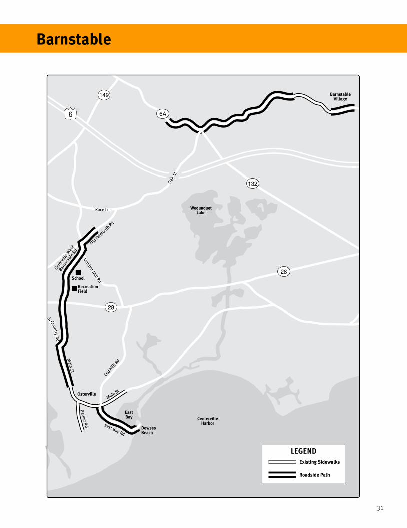
31
Barnstable
6
132
132
28
28
149
6A
LEGENDExisting Sidewalks
Roadside Path
EastBay
DowsesBeach
CentervilleHarbor
WequaquetLake
BarnstableVillage
OstervilleMain St
Parker Rd
Main St
Oster
ville
-Wes
t
Barns
tabl
e Rd
Old Falm
outh Rd
Lumber M
ill Rd
Race Ln
Oak
St
East Bay Rd
Old M
ill R
d
School
RecreationField
S. Country Rd

32
Type of walking infrastructure:
Strategies:
Traditional sidewalks in town center; trails in public reservations
Traffic calming for town center streets; removal of existing pavement; addition of curb extensions
Case Study 4.4. Barre
A rural town located in the center of Massachusetts, Barre is about 20 miles northwest of Worcester and 60 miles northwest of Boston. Barre’s town center includes businesses, churches, residences and a public library surrounding the town common. The common is truly the heart of town, with businesses where State Routes 122 and 32 intersect, diagonal walking paths, extensive lawns, a Civil War monument and fountain, and a bandstand used for weekly concerts in the summer.
Residential development surrounds the town center, and ends in farms and wooded areas within a few blocks. At the edge of the residential area lie the
Barre Center parking area
town school (on Ruggles Lane), the town hall (in the Henry Woods Building), and the 60-acre Mass Audubon Cook’s Canyon Wildlife Sanctuary, a small ravine with a waterfall where the brook flows over a dam. Barre’s town common is now the focus of a major street rebuilding project. The common essentially forms an inverted triangle 400’ wide at the base and extending for 700’ on both sides before ending in a point. Highway routes pass directly adjacent to the common and diagonally across it. The roadways framing the common produce five major intersections. In the last 5 years, the streets surrounding the common have been the site of 492 property damage accidents.

33
The Barre Center project involves several commonly-used traffic calming features:
• Roadway reclamation: South Street and Exchange Street currently pass through a large open area used for parking. South Street will be relocated by shifting its alignment several feet east, closer to Exchange Street. Exchange Street will be narrowed to serve solely as access to diagonal parking. The net gain of space added to the common is shown on the adjacent map.
• Narrowing vehicle lanes: The north part of the common (North Park), bordered by Broad, Park, School and Pleasant Streets, will be surrounded by new parking lanes taken from existing travel lanes. There will be a curb extension at the end of each new parking lane, to make pedestrian crossings shorter and safer. Similar changes along Common Street, but with some curb extensions, will create a parking lane and narrow the street.
• Converting vehicle travel lanes to other uses: Low curbs will be added to all streets within the project area around the common to narrow the area available to vehicles and provide space for parking lanes. Grove Street, which currently cuts through the common, will be removed and replaced with a bricked walkway, and its right of way will be added to the common.
• Improving pedestrian infrastructure: New curbed sidewalks will be built along the business side of all streets bordering the common. Furthermore, sidewalks will be added around three sides of the north end of the common and along Pleasant Street through the lower part of the common. The curbing along the common will be distinctive, made of low-lying cobblestones, instead of the usual 6” high granite curbs.
• Changing parking configuration: Two new parking areas will be created from existing short and redundant streets. Both Moulton Street and Exchange Street will be redesigned to provide diagonal parking near the main business buildings.
Barre
• Adding buffer space: Both of the streets rebuit solely for parking access - Moulton Street and Exchange Street - will have buffers of landscaped space and sidewalks that are accessible to walkers.
• Adding bike lanes: Following the street rebuilding project, bike lanes can be put into place, because reconstructed roadways will have sufficiently wide shoulders to accommodate them.
Removed Street
New PathR
ecol
ated
Str
eet
Reco
late
d St
reet
Grove St
Comm
on St
Exchange St
Mechanic St (Rte. 62)
Summer St (Rtes. 32
& 122)
Sou
th S
t
James St
Moulton
St
School St
School St
School S
t North
Broad St
Barre Rd (Rtes. 32 & 122)
Park St
North Park
North Common
South Common
BandStand
Parking
Pa
r ki n
g
Pa
r ki n
g
Pa
r ki n
gP
ar k
i ng
P a r k i n gP a r k i n g
Pa
r ki n
g
Pa
r ki n
g
LEGEND
Neckdown
New Sidewalk
Existing Sidewalk (to be rebuilt)
New Park Land
Street Made into Parking Lot
Crosswalk

34
Type of walking infrastructure:
Strategies:
Bolton lies within a ring of towns at the edge of Route I-495 as it circles the greater Boston metro area. A semi-rural, primarily residential community with open fields, orchards and a vineyard, Bolton has a small cluster of offices at the I-495/Route 117 interchange and several retail establishments scattered along Route 117. The town center consists of the town hall, community center, library, middle and elementary schools, and a small number of shops. Neighborhoods are interwoven among open fields, orchards and a vineyard. The major highways that serve Bolton include I-495, which bisects the community north-south, and Route 117, which runs east-west and functions as the town’s Main Street and is the most heavily used local travel route.
Bolton has three types of walking infrastructure. It has constructed sidewalks in the town center, lining both sides of the street for about 1,500 feet. Outside the town center, there are no sidewalks, but a number of recreational trails have been created on conservation land. In addition, with state assistance, Bolton has added shoulders to Route 117 between the I-495 interchange and the eastern town line; however, this is intended for adult bicyclists, and is not heavily used by pedestrians.
In 2012, Bolton took a proactive approach to creating more walking infrastructure. The Bolton Board of Selectmen approved the formation of a Subcommittee to develop a Mobility Plan, which will be incorporated into the town’s long-range Master Plan. The town requested volunteers to be part of the Mobility Plan Subcommittee, especially walkers, cyclists, and parents of schoolchildren.
The town’s solicitation included the following:“Are you looking for alternative ways to get around town without using an automobile? Would you like to access town facilities, such as schools, the library and town hall, churches, the post office, Sidewalks in Bolton’s town center, running along Route 117
Sidewalks in town center; recreational trails in conservation areas
Creation of Mobility Plan; walking preference survey; forum of residents to identify and prioritize desired walking infrastructure
Case Study 4.5 Bolton
shops, parks and recreational sites, and link up to Bolton’s large number of trails, without getting the car out?... Anyone who has tried [walking, jogging, or bicycling] will have experienced the unsafe conditions… on Bolton’s busy roads, which do not have walkways or bike lanes… Many of our neighboring towns, including Stow, Acton, Sudbury and Lincoln, have been gradually putting in walkways as a result of plans they made 10 to 20 years ago. The plan will draw from those,… but be specific to Bolton’s needs and include identifying and prioritizing opportunities, exploring funding sources and examining legal issues.”
Following the establishment of the Mobility Plan Subcommittee in early spring 2012, Bolton’s town planner contacted WalkBoston for assistance with investigating walking infrastructure opportunities in the town.
To prepare for a public meeting in the fall to discuss walkway options, the Mobility Plan Subcommittee, with WalkBoston assistance, agreed on the following work plan:

35
Bolton
• Conduct a survey of all Bolton residents about their walking preferences. The town planner developed the initial survey draft, and members of the Subcommittee and WalkBoston provided comments. The survey was administered and completed at the end of Summer 2012.
• Examine the results of a similar survey in nearby Stow. Consider other towns’ policies and approaches to non-motorized transportation, especially walking.
• Travel to Boxborough to examine a unique bridge over wetlands and a 3,000-foot walkway connecting public buildings and the town’s retail center.
• Develop maps of existing walking routes and trails in Bolton and graphics of possible walkway types. Consider use of WalkBoston’s Walk-By Visioning technique to gain insight into participants’ walking preferences. Review Bolton’s Open Space Plan, conservation land data, and landscape inventory.
• Recruit (WalkBoston’s assignment) two volunteer landscape architects (Tom Doolittle and Don Kindsvatter) to develop walkway options for the town-owned land behind the middle and elementary schools.
• Prepare a PowerPoint presentation summarizing the key information and walking infrastructure options. (Town planner)
The Mobility Subcommittee held its public meeting on November 27, 2012 at the Bolton Public Library. Subcommittee members shared the survey results, reflecting 300 completed household surveys (953 residents).1. More walkways in Bolton? (89% yes)2. Location of walkways: on lanes (19% yes) on minor roads (31% yes) side/secondary roads (77% yes) and major roads (87% yes)3. Likely use of walkways: exercise (91%) access to destinations (74%) bike riding (62%)
walking with children (54%) walking pets (53%)4. Destinations walkways should connect: recreation areas (79%) library (76%) schools (73%) conservation lands/trails (69%); commercial areas (58%); town hall (54%)5. Safety concerns: heavy traffic (4.2 points out of 5) speed of cars (4.0) lack of sidewalks (3.9)6. Paved shoulder along Route 117? (83% yes)7. Paved shoulder on other major roads? (82% yes)8. Back of the schools site – improvements to
paths? (73% yes)
Subcommittee members then reviewed the different roadway types present in Bolton (lanes, minor roads, side/secondary, and major roads); their principal characteristics, such as volumes of traffic and general speeds; and potential walkway types in Bolton (sidewalks, trails on railroad beds, trails as unpaved walkways, and bicycle lanes). Attendees were asked to prioritize the different types of walkways and draw their recommendations for new walkways on town maps. Participant teams then evaluated the different proposals using WalkBoston’s Walk-By Visioning technique, and recorded the ones that were top-rated for future reference. For more information on Walk-By Visioning, visit http://walkboston.org/resources/publications-products and download the Public Participation brochure.
Subsequently, Tom Doolittle and Don Kindsvatter presented opportunities to connect Bolton’s two schools, senior center, recreational fields, library, community garden, office park, public safety building, and Nashoba Valley Winery using town-owned land. They proposed a 1.5-mile loop walkway, combining existing town sidewalks and paths with some additional links, and a signage system to establish a trail identity and assist with wayfinding.
At the conclusion of the forum, the Mobility Subcommittee agreed to move forward by analyzing attendees’ comments to compile a list of walkway preferences.
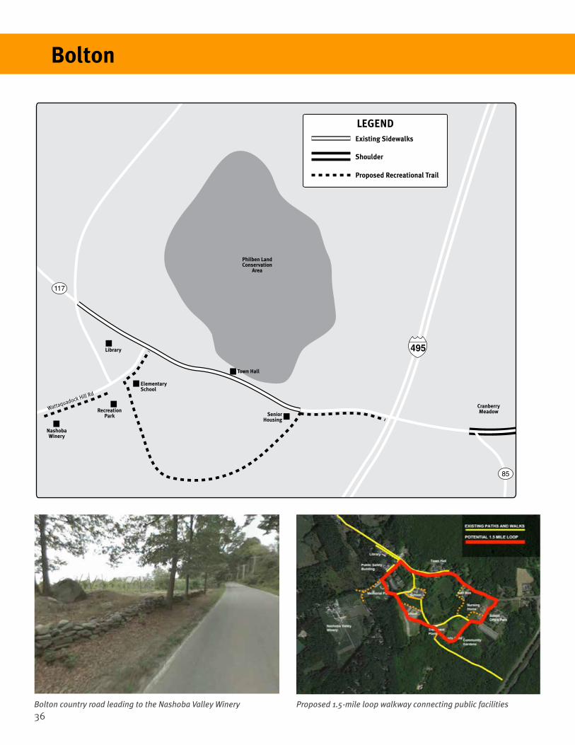
36
Philben LandConservation
Area
NashobaWinery
RecreationPark
CranberryMeadow
117
85
Wattaquadock Hill Rd
Library
Town Hall
ElementarySchool
SeniorHousing
495
LEGENDExisting Sidewalks
Shoulder
Proposed Recreational Trail
Proposed 1.5-mile loop walkway connecting public facilitiesBolton country road leading to the Nashoba Valley Winery
Bolton

37
Type of walking infrastructure:
Strategies:
Case Study 4.6 Boxborough
Boxborough is a town of 4,996 people, located adjacent to an interchange between Route I-495 and Route 111. The town’s desirable location relative to these two highways has created residential construction and modest retail development in the town center.
Boxborough’s town center is relatively linear, extending along Route 111 from Middle Road (Stow Road) toward Acton. Almost all of the town’s public buildings, with the exception of the post office, lie within this stretch. The town center also features a bank, a small shopping center, offices, a community center, the town hall and some multi-family housing.
Boxborough has worked hard to create a long pedestrian pathway through the town center, generally parallel to Route 111. The path links nearly all of the town’s public buildings, including the new public library, elementary school, and the sites of police, public works and fire department buildings. Within a short time, the final 200 feet of the path, connecting the town hall and community center, will be completed. Counting the last segment, the path is roughly 3,000 feet long, more than a half mile in total. It includes a $25,000 bridge over wetlands, built by volunteers and then landscaped by middle-school students.
The pedestrian path resulted from a unique planning, design and construction process.
Planning and design:• Prominent use of town-owned land: About half
of the path is located on town land – the path between the elementary school and library; and the path in front of the fire department vehicle entrance and the police station. The fire and police department parking area also serves as a location for parents picking up children from the school across the street.
• Crosswalks on both state and local streets: State and local road crosswalks include one on Route 111, connecting the elementary school and the fire station and another connecting a 48-unit housing development and a small shopping plaza across Middle Street. A future crosswalk is planned to connect Middle Street across Route 111. At this intersection, the path makes a 90-degree turn, leading from the south to the north side of the street for a connection to the town hall. One local crosswalk links the town hall and the community center on a local street.
• Developer-provided roadside path: From the police station to the main intersection, 1,900 feet of the path extends in front of a privately-owned development, along the right-of-way for Route 111. The developer made an agreement with the town to build the path before constructing the residential buildings. The path has a meandering design, climbing low hills that were not flattened by the construction of the roadway and turning to bypass trees and rocks, in order to make it more interesting for pedestrians.
• Utility-provided lighting: The local electric utility company, Littleton Electric Light and Water Department, provided five lighting fixtures for the path between the library and school that includes the bridge.
• Easement to provide a right-of-way for a roadside path: The town negotiated an easement along 200 feet of private land fronting Middle Road to allow the construction of a sidewalk to town hall. The path will be paid for with town funds.
• Collaboration between town staff and departments: Both Elizabeth Hughes, Town Planner, and Tom Garmon, Director of Public
Meandering paths in town center; new bridge built by volunteers from kit
Continue roadside paths from town center outward; goal of path along full length of Main Street (Rte 111)

38
Works, took an active role in the project. The Public Works Department constructed the 600-foot asphalt path between the elementary school and library with funding from its regular budget.
• Landscaping done by local students: Near the bridge entrance, 6th grade students planted four small native plant gardens. School officials also added a large seating area outlined with rocks, with a ground surface of wood chips to be used as an outdoor classroom, and another seating area for walkers to rest.
Elements of the path:• Meandering path between the elementary
school and the library: The town’s Department of Public Works designed the 600 foot long path between the library and elementary school to be made of asphalt, excluding the crossing of a small stream. This section is called the Garabedian Trail honoring a family that supported local public education.
• Bridge across the stream: The town purchased the fiberglass bridge as a kit from E.T. Techtonics in Philadelphia, PA for $25,000. The funding for the bridge and its approaches was included in the new library’s construction budget. The Town Planner worked with a professional civil engineer to obtain a stamp for the bridge, as required by the Commonwealth of Massachusetts. The Public Works Department set up the underlying support structure, and the consulting engineer partnered with a contractor to construct the bridge’s supports. With the supports in place, 18 community volunteers worked 8 hours to assemble the bridge.
• Route 111 crosswalk: At the end of the path
between the elementary school and the fire department building, a crosswalk was added to connect school property to the public buildings on the opposite side of Route 111. The fire and police department lots area also serve as a location for parents picking up children from the school across the street. Signs warn drivers that pedestrians are crossing the street in this area.
• Fire and police department roadside path: A path was painted across the fire department asphalt driveway for $400, to mark off a route for pedestrians. The path was painted a bright green, making it very noticeable to drivers in the vicinity. An unpainted path continues in front of the police department headquarters building.
• Developer’s roadside path: A meandering path leading from the police station to Middle Street at the center of the village was built as part of a developer’s obligation to the town in connection with the construction of a large residential complex.
• Middle Street crosswalk: The state has approved construction at the intersection of Route 111 and Middle Street. The path turns north here, leading from the south to the north side of the street and connects to the town hall.
• Easement on private land: The town is negotiating an easement on land fronting Middle Road which will allow for construction of a sidewalk leading to the town hall. The path will be paid for with town funds.
• A town road crosswalk: Town hall is directly across the street from the community center. This crosswalk will connect the two major meeting places for individuals and organizations in the town.
Boxborough’s 600-foot long meandering path between its elementary school and library
Boxborough
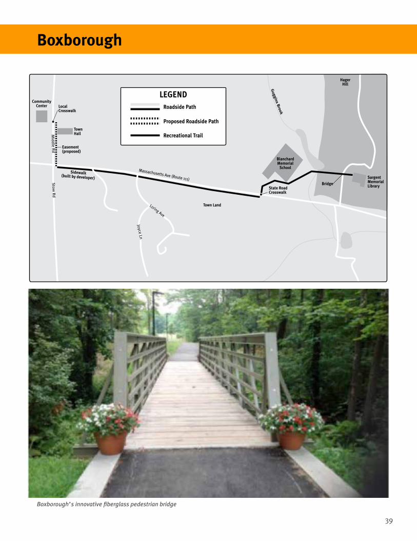
39
Boxborough’s innovative fiberglass pedestrian bridge
Boxborough
TownHall
Easement(proposed)
Sidewalk(built by developer)
CommunityCenter Local
Crosswalk
Stow
Rd
Loring Ave
Joyce Ln
Massachusetts Ave (Route 111)
Mid
dle R
d
State RoadCrosswalk
Bridge
Town Land
BlanchardMemorial
School
Guggins B
rook
HagerHill
SargentMemorialLibrary
LEGENDRoadside Path
Proposed Roadside Path
Recreational Trail
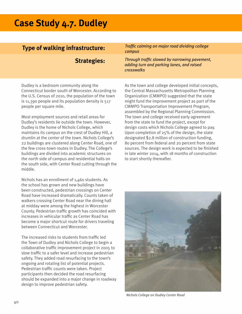
40
Type of walking infrastructure:
Strategies:
Case Study 4.7. Dudley
Dudley is a bedroom community along the Connecticut border south of Worcester. According to the U.S. Census of 2010, the population of the town is 11,390 people and its population density is 517 people per square mile.
Most employment sources and retail areas for Dudley’s residents lie outside the town. However, Dudley is the home of Nichols College, which maintains its campus on the crest of Dudley Hill, a drumlin at the center of the town. Nichols College’s 22 buildings are clustered along Center Road, one of the few cross-town routes in Dudley. The College’s buildings are divided into academic structures on the north side of campus and residential halls on the south side, with Center Road cutting through the middle.
Nichols has an enrollment of 1,460 students. As the school has grown and new buildings have been constructed, pedestrian crossings on Center Road have increased dramatically. Counts taken of walkers crossing Center Road near the dining hall at midday were among the highest in Worcester County. Pedestrian traffic growth has coincided with increases in vehicular traffic as Center Road has become a major shortcut route for drivers traveling between Connecticut and Worcester.
The increased risks to students from traffic led the Town of Dudley and Nichols College to begin a collaborative traffic improvement project in 2005 to slow traffic to a safer level and increase pedestrian safety. They added road resurfacing to the town’s ongoing and rotating list of potential projects. Pedestrian traffic counts were taken. Project participants then decided the road resurfacing should be expanded into a major change in roadway design to improve pedestrian safety.
Traffic calming on major road dividing college campus
Through traffic slowed by narrowing pavement, adding turn and parking lanes, and raised crosswalks
As the town and college developed initial concepts, the Central Massachusetts Metropolitan Planning Organization (CMMPO) suggested that the state might fund the improvement project as part of the CMMPO Transportation Improvement Program, assembled by the Regional Planning Commission. The town and college received early agreement from the state to fund the project, except for design costs which Nichols College agreed to pay. Upon completion of 25% of the design, the state designated $2.8 million of construction funding, 80 percent from federal and 20 percent from state sources. The design work is expected to be finished in late winter 2014, with 18 months of construction to start shortly thereafter.
Nichols College on Dudley Center Road
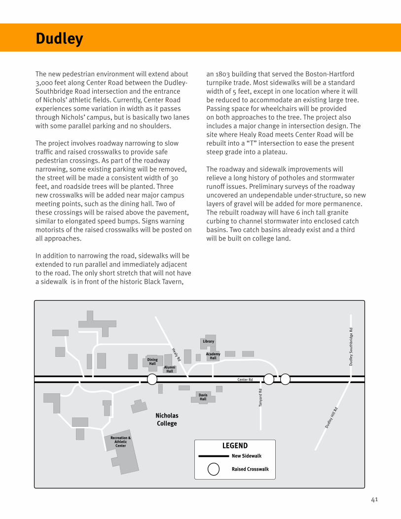
41
The new pedestrian environment will extend about 3,000 feet along Center Road between the Dudley-Southbridge Road intersection and the entrance of Nichols’ athletic fields. Currently, Center Road experiences some variation in width as it passes through Nichols’ campus, but is basically two lanes with some parallel parking and no shoulders.
The project involves roadway narrowing to slow traffic and raised crosswalks to provide safe pedestrian crossings. As part of the roadway narrowing, some existing parking will be removed, the street will be made a consistent width of 30 feet, and roadside trees will be planted. Three new crosswalks will be added near major campus meeting points, such as the dining hall. Two of these crossings will be raised above the pavement, similar to elongated speed bumps. Signs warning motorists of the raised crosswalks will be posted on all approaches.
In addition to narrowing the road, sidewalks will be extended to run parallel and immediately adjacent to the road. The only short stretch that will not have a sidewalk is in front of the historic Black Tavern,
an 1803 building that served the Boston-Hartford turnpike trade. Most sidewalks will be a standard width of 5 feet, except in one location where it will be reduced to accommodate an existing large tree. Passing space for wheelchairs will be provided on both approaches to the tree. The project also includes a major change in intersection design. The site where Healy Road meets Center Road will be rebuilt into a “T” intersection to ease the present steep grade into a plateau.
The roadway and sidewalk improvements will relieve a long history of potholes and stormwater runoff issues. Preliminary surveys of the roadway uncovered an undependable under-structure, so new layers of gravel will be added for more permanence. The rebuilt roadway will have 6 inch tall granite curbing to channel stormwater into enclosed catch basins. Two catch basins already exist and a third will be built on college land.
Dudley
DiningHall
Recreation &AthleticCenter
AlumniHall
DavisHall
AcademyHall
Library
NicholasCollege
Center Rd
Dud
ley
Hill
Rd
Du
dle
y S
ou
thb
rid
ge R
d
Healy Rd
LEGENDNew Sidewalk
Raised Crosswalk
Tany
ard
Rd

42
Type of walking infrastructure:
Strategies:
Located on the Connecticut River in western Massachusetts, Hadley is one of the towns in the Connecticut River Valley. According to the 2010 U.S. Census, it has a population of 4,793 residents and a population density of 205 persons per square mile.
Hadley is known for its rich farmland. However, it is also a major regional shopping area, with retail outlets lining Route 9 between Amherst and Northampton. It also includes parts of the University of Massachusetts – Amherst campus. Hadley has a significant old town center, located where Routes 9 and 47 intersect. This town center includes the town hall, library, and the Hadley Farm Museum. Highways serving Hadley include not only Route 9, but also Route 47, which has been designated as a scenic byway through most of Hadley.
While Hadley has no official plan for walkways within the town, it has four types of walking infrastructure, three of which are relatively uncommon in Massachusetts. These types include an ancient linear town common; a walkway along a riverside levee; a path through a unique 17th-century field system; and a rail trail that connects Hadley to its neighbors, Northampton and Amherst. Pedestrians can experience all four types of walkways within in a two-hour walk.
Hadley’s lineal town common
Linear town common; walkway on riverbank levee; path in 17th-Century fields; rail-trail
Partnership with conservation organizations, including the World Monument Foundation for the Great Meadow farming area
Case Study 4.8. Hadley
Hadley’s Linear CommonWhen English Puritans settled Hadley in 1659, the colonists laid out village lots, a common, and space for fields. Unlike the typical New England common, usually a field for grazing animals, the Hadley Common is a unique linear open space a mile long and about 100 feet wide, bounded on both sides by the north- and south-bound roadways that comprise West Street. The common encompasses an area of nearly five acres as it reaches from the river on one side of Hadley’s peninsula to the river on the south side of the town. Some of the town’s oldest homes border the common. Connecticut River LeveeFollowing the great floods in 1936, a 2.5-mile long levee was constructed along the Connecticut River. The levee is about 10 feet high and is designed to protect the town from flood damage. A walkway runs along the top of the levee and provides views over the river south towards the Holyoke Range. Although it is unpaved, the path is maintained for walking.
The Connecticut River is now protected by a number of federal and state initiatives. It is part of the federal Silvio O. Conte National Fish and Wildlife Refuge, as well as the Connecticut River Greenway State Park, which consists of a number of separate
Hadley’s Connecticut River levee

43
state land holdings in the Connecticut River Valley. In 2012, the U.S. Department of the Interior designated all 410 miles of the river, as well as its 7.2 million acre watershed, as the first National Blueway to recognize and support local and regional conservation efforts. The section of Route 47 that abuts the Hadley side of the river alongside the levee has been named a Connecticut River National Scenic Farm Byway.
Great MeadowThis 350+ acre open space is the town’s original farming area, and preserves a unique 17th-century layout. Puritan settlers laid out the long slender fields, designed to be plowed by oxen in 1661, with settlers receiving individual strips. The land was
Great Meadow
Hadley
reserved for agricultural use and families lived on land near the linear common. While this type of open-field farming was widely used in medieval Europe, as well as in some early New England settlements, most examples had disappeared by the eighteenth century. The World Monuments Fund has acknowledged the Great Meadow as a landmark deserving of protection. In 2010, it added the Great Meadow to its watch list because 165 acres remain zoned for residential and commercial development. An unpaved trail runs north-south through the Great Meadow, along a narrow creek. The trail connects to Cross Path Road, which in turn leads to the Norwottuck Rail Trail.
Norwottuck Rail TrailThe Massachusetts Department of Conservation and Recreation (DCR) created the Norwottuck Rail Trail in 1993 along the route of the former Central Massachusetts Railroad Line, which ran between Boston and Northampton. The railroad was an active railroad from 1889 until 1979, and the property was acquired by the DCR in 1985. The Hadley Historical Commission suggested the name “Norwottuck” for the trail. Historians believe that the Native American tribe who lived in the area before Europeans arrived were called the Norwottuck. Translated, the term means “in the midst of the river.” The Norwottuck Trail leads through Hadley’s town center, and intersects with West Street and the linear town common.
Library
ElementarySchool
Connecticut River
Norwottuck Rail Trail
River Levee Path
Great M
eadow Path
TownHall
ElwellState Park
Hadley
Northampton
47
47
Cemetery Rd
Bay Rd
Old Linear Tow
n Comm
onW
est St
Middle St
East St
North La
Cross Path Rd
North La
91
Russel St
9
9
LEGENDExisting Sidewalks
Recreational Trail

44
Type of walking infrastructure:
Strategies:
Lenox is located in western Massachusetts in the Berkshire Hills. The town is relatively compact, with a town center located at the intersection of Route 183 (Walker/West Street) and Main Street/Old Stockbridge Road. The town center contains municipal offices, shops, and the post office. Hotels and guest-houses are spread throughout the town, with a concentration near the town center.
During the Gilded Age, Lenox was a vacation town for wealthy individuals. Today, it is recognized for its cultural establishments, which include important art, theater, and music venues. Major attractions within walking distance of the town center include Ventfort Hall/Gilded Age Museum, the Shakespeare & Company Theater Company, and Tanglewood. Lenox is located along the major north-south highways in Berkshire County, Routes 7, 7A, and 20. The town’s attractions, plus good access from these highways, bring in many seasonal visitors.
A recently constructed roadside path runs from the town center past the elementary school to the Tanglewood Musical Center, the Boston Symphony
Sidewalk and roadside path connections from town center to major tourist attractions
Radial network of sidewalks and paths outward from town center; use of asphalt paths
Case Study 4.9. Lenox
Roadside path from Lenox’s town center to the Tanglewood Musical Center
Orchestra’s summer home. This path, constructed along the south side of West Street, provides a scenic walking route that serves as a pleasant alternative to getting stuck in traffic along the road to Tanglewood. Lenox’s Select Board considered whether to make the path concrete or asphalt, with concrete lasting for 15-20 years and asphalt lasting for 5-6 years. They also discussed using a combination of the two, to protect the roots of some adjacent trees. Ultimately, they decided to use asphalt, believing that the two types of construction mixed together would be unappealing aesthetically.
TanglewoodMusical Center
Lenox
StockbridgeElm
Court
VentfortHall
LenoxCenter
ElementarySchool
Hotels
Hotels
Library
Town Hall
Shopping Center
HighSchool
Shakespeareand Co.
West St
West Hawthorne Rd
Walker St
East St
Kem
ble
St
Old
Sto
ckbr
idge
Rd
Mai
n St
20
7
183
183
7A
7ALEGENDExisting Sidewalks
Roadside Path
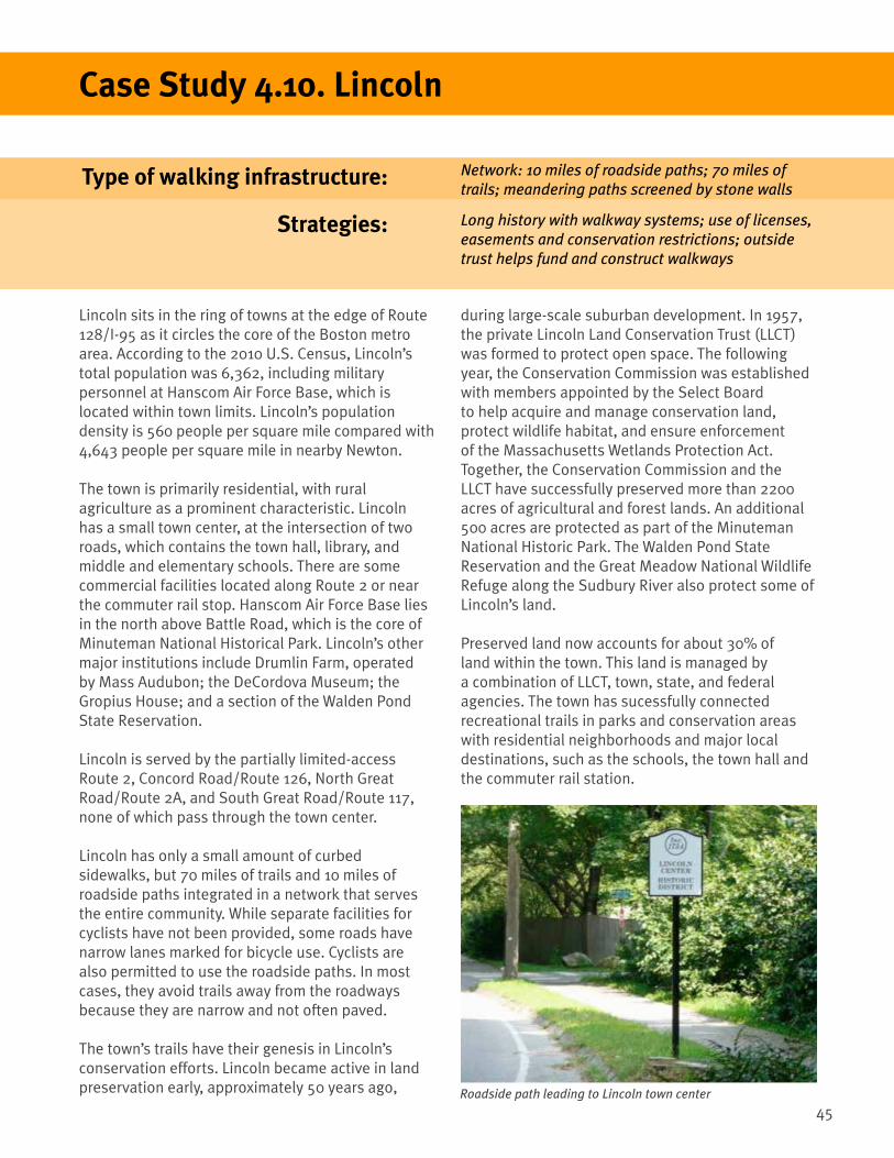
45
Type of walking infrastructure:
Strategies:
Case Study 4.10. Lincoln
Lincoln sits in the ring of towns at the edge of Route 128/I-95 as it circles the core of the Boston metro area. According to the 2010 U.S. Census, Lincoln’s total population was 6,362, including military personnel at Hanscom Air Force Base, which is located within town limits. Lincoln’s population density is 560 people per square mile compared with 4,643 people per square mile in nearby Newton.
The town is primarily residential, with rural agriculture as a prominent characteristic. Lincoln has a small town center, at the intersection of two roads, which contains the town hall, library, and middle and elementary schools. There are some commercial facilities located along Route 2 or near the commuter rail stop. Hanscom Air Force Base lies in the north above Battle Road, which is the core of Minuteman National Historical Park. Lincoln’s other major institutions include Drumlin Farm, operated by Mass Audubon; the DeCordova Museum; the Gropius House; and a section of the Walden Pond State Reservation.
Lincoln is served by the partially limited-access Route 2, Concord Road/Route 126, North Great Road/Route 2A, and South Great Road/Route 117, none of which pass through the town center.
Lincoln has only a small amount of curbed sidewalks, but 70 miles of trails and 10 miles of roadside paths integrated in a network that serves the entire community. While separate facilities for cyclists have not been provided, some roads have narrow lanes marked for bicycle use. Cyclists are also permitted to use the roadside paths. In most cases, they avoid trails away from the roadways because they are narrow and not often paved.
The town’s trails have their genesis in Lincoln’s conservation efforts. Lincoln became active in land preservation early, approximately 50 years ago, Roadside path leading to Lincoln town center
Network: 10 miles of roadside paths; 70 miles of trails; meandering paths screened by stone walls
Long history with walkway systems; use of licenses, easements and conservation restrictions; outside trust helps fund and construct walkways
during large-scale suburban development. In 1957, the private Lincoln Land Conservation Trust (LLCT) was formed to protect open space. The following year, the Conservation Commission was established with members appointed by the Select Board to help acquire and manage conservation land, protect wildlife habitat, and ensure enforcement of the Massachusetts Wetlands Protection Act. Together, the Conservation Commission and the LLCT have successfully preserved more than 2200 acres of agricultural and forest lands. An additional 500 acres are protected as part of the Minuteman National Historic Park. The Walden Pond State Reservation and the Great Meadow National Wildlife Refuge along the Sudbury River also protect some of Lincoln’s land.
Preserved land now accounts for about 30% of land within the town. This land is managed by a combination of LLCT, town, state, and federal agencies. The town has sucessfully connected recreational trails in parks and conservation areas with residential neighborhoods and major local destinations, such as the schools, the town hall and the commuter rail station.

46
Lincoln
With continued usage of the paths, a sorting process of users has taken place. Many long-distance bicycle riders avoid roadside paths considered too narrow, hilly, or meandering, preferring to use the road pavement instead, even if it means sharing the space with vehicles. As a result, the roadside paths are used primarily by pedestrians and children with smaller bicycles. The town has added striping to some roads to help cyclists ride safely.
In addition, Lincoln’s roadside paths are often supplemented by its trails. For example, the town’s school, near the town center, can be reached by a north-south roadside path along Lincoln Road, or through a network of off-road trails crossing town conservation land and/or privately-owned property. Collectively, there are six different ways of getting to the school on paths from surrounding residential areas.
Lincoln created its first roadside paths in the 1950s to provide safe routes for pedestrians and bicyclists, otherwise forced to use narrow and sometimes dangerous local roads. To construct these paths, Lincoln had to find land along its main roads, Lincoln and Trapelo Roads, into the town center. Paths were planned for only one side of the roads with crosswalks at selected locations in the town center to enable access to the schools, town hall, library, and churches.
Since the town- or state-owned rights-of-way along the roads were narrow, paths were initially laid out close to the roads, with only a narrow strip of land separating them from the pavement. However, Lincoln’s Town Meeting members rejected this design because they wanted paths that did not destroy roadside trees. A revised design was approved, creating meandering routes roughly parallel to roads while avoiding major trees. Where possible, paths were located behind low stone walls to preserve the area’s rural appearance by making the paths less apparent. LLCT and town staff established path routes through outright purchase of land or agreements with property owners.
Over time, the town constructed roadside paths along the rest of Lincoln and Trapelo Roads, as well as along parts of Concord Road/Route 126, South Great Road/Route 117, Weston Road, and Bedford Road. The paths along North Great Road were built separately by the federal government as part of the Minuteman National Historical Park, but have been incorporated into the town’s network of paths.
Roadside path behind stone wall in Lincoln
Roadside path behind stone wall in Lincoln

47
Many of Lincoln’s roadside paths and trails involve combinations of easements, conservation restrictions, and licenses. For example, one nearly continuous trail runs through many properties, with the owners having granted either a license or an easement. While licenses can always be revoked, they do provide at least temporary public access and allow the path system to remain operational.
Maintaining the paths and trails also can be challenging. The town takes responsibility for most of the roadside paths, and LLCT for most trails. In addition, ensuring easy wayfinding can be difficult. For example, walkers may find it difficult to locate paths across cultivated fields protected by agricultural conservation restrictions. Here, signage can play an important role.
Lincoln
In the future, Lincoln plans to continue its program of land conservation to build more trail connections, provide recreational opportunities, protect wildlife corridors and other ecologically significant areas, and preserve farmland. Currently, it is considering how to conserve the town’s few remaining large parcels, as well as certain smaller parcels that provide critical links between these large parcels.
117
117
126
126
22
2
2A 2A
Sandy Pond Rd
Baker Bridge Rd
Weston Rd
Codman Rd
Wes
ton
Rd
Tow
er R
d
Trapelo Rd
Hanscom
Dr
Bedford
Rd
Bedf
ord
Rd
Lincoln Rd
Old Sudbury Rd
ToddPond
BeaverPond
CambridgeReservoir
FlintsPond
WaldenPond
DeCordovaMuseum
Library
TownHall
Museum
Museum
ElementarySchool
ElementarySchool
Cemetery
RailroadStation
Drumlin FarmWildlife
Sanctuary
MBTA Com
muter Rail
Minute ManNational
Historic Park
Lincoln
Concord
Waltham
LEGENDRoadside Path
Recreational Trail
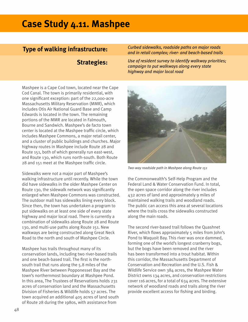
48
Type of walking infrastructure:
Strategies:
Mashpee is a Cape Cod town, located near the Cape Cod Canal. The town is primarily residential, with one significant exception: part of the 22,000-acre Massachusetts Military Reservation (MMR), which includes Otis Air National Guard Base and Camp Edwards is located in the town. The remaining portions of the MMR are located in Falmouth, Bourne and Sandwich. Mashpee’s de facto town center is located at the Mashpee traffic circle, which includes Mashpee Commons, a major retail center, and a cluster of public buildings and churches. Major highway routes in Mashpee include Route 28 and Route 151, both of which generally run east-west, and Route 130, which runs north-south. Both Route 28 and 151 meet at the Mashpee traffic circle.
Sidewalks were not a major part of Mashpee’s walking infrastructure until recently. While the town did have sidewalks in the older Mashpee Center on Route 130, the sidewalk network was significantly enlarged when Mashpee Commons was constructed. The outdoor mall has sidewalks lining every block. Since then, the town has undertaken a program to put sidewalks on at least one side of every state highway and major local road. There is currently a combination of sidewalks along Route 28 and Route 130, and multi-use paths along Route 151. New walkways are being constructed along Great Neck Road to the north and south of Mashpee Circle.
Mashpee has trails throughout many of its conservation lands, including two river-based trails and one beach-based trail. The first is the north-south trail that runs along the 5.8 miles of the Mashpee River between Popponesset Bay and the town’s northernmost boundary at Mashpee Pond. In this area, The Trustees of Reservations holds 231 acres of conservation land and the Massachusetts Division of Fisheries & Wildlife holds 57 acres. The town acquired an additional 405 acres of land south of Route 28 during the 1980s, with assistance from
Two-way roadside path in Mashpee along Route 151
Case Study 4.11. Mashpee
Curbed sidewalks, roadside paths on major roads and in retail complex; river- and beach-based trails
Use of resident survey to identify walkway priorities; campaign to put walkways along every state highway and major local road
the Commonwealth’s Self-Help Program and the Federal Land & Water Conservation Fund. In total, the open space corridor along the river includes 432 acres of land and approximately 9 miles of maintained walking trails and woodland roads. The public can access this area at several locations where the trails cross the sidewalks constructed along the main roads.
The second river-based trail follows the Quashnet River, which flows approximately 5 miles from John’s Pond to Waquoit Bay. This river was once dammed, forming one of the world’s longest cranberry bogs, but the bogs have been removed and the river has been transformed into a trout habitat. Within this corridor, the Massachusetts Department of Conservation and Recreation and the U.S. Fish & Wildlife Service own 384 acres, the Mashpee Water District owns 134 acres, and conservation restrictions cover 116 acres, for a total of 634 acres. The extensive network of woodland roads and trails along the river provide excellent access for fishing and birding.
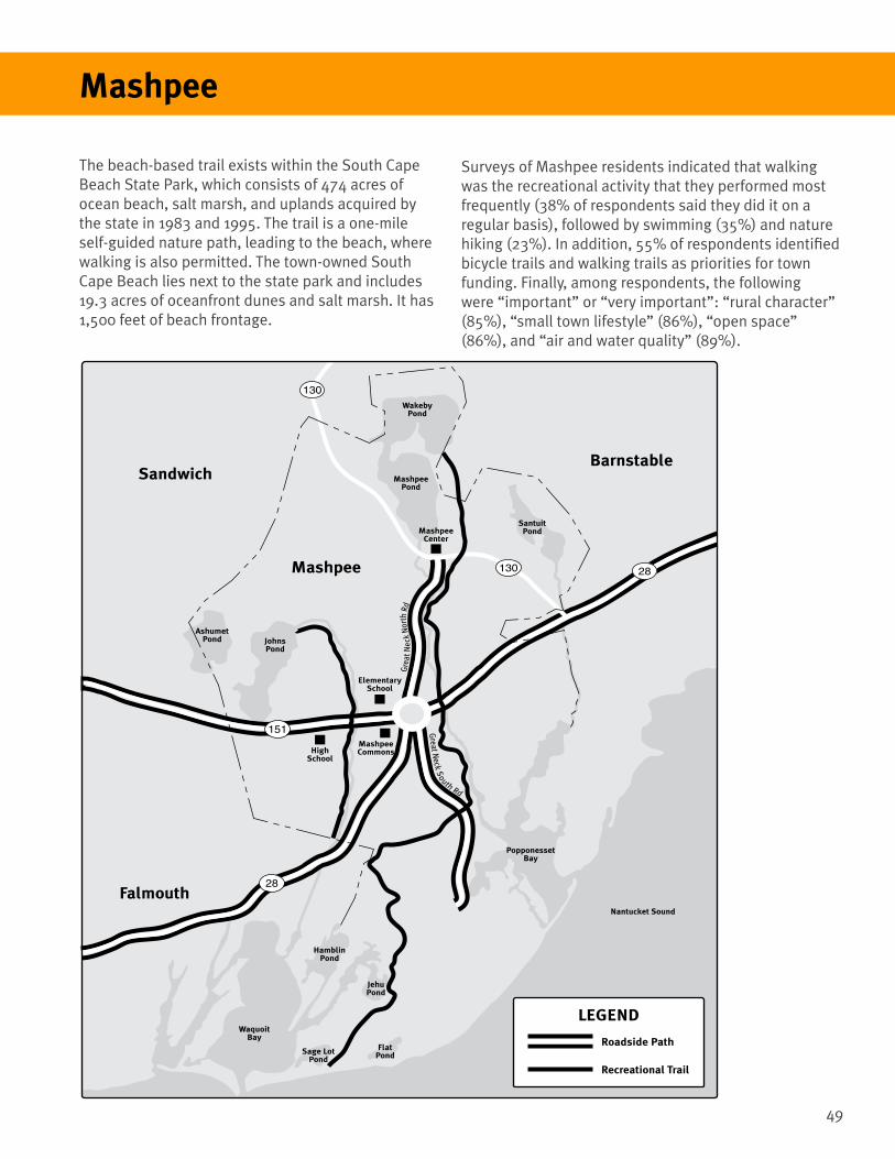
49
Mashpee
The beach-based trail exists within the South Cape Beach State Park, which consists of 474 acres of ocean beach, salt marsh, and uplands acquired by the state in 1983 and 1995. The trail is a one-mile self-guided nature path, leading to the beach, where walking is also permitted. The town-owned South Cape Beach lies next to the state park and includes 19.3 acres of oceanfront dunes and salt marsh. It has 1,500 feet of beach frontage.
Surveys of Mashpee residents indicated that walking was the recreational activity that they performed most frequently (38% of respondents said they did it on a regular basis), followed by swimming (35%) and nature hiking (23%). In addition, 55% of respondents identified bicycle trails and walking trails as priorities for town funding. Finally, among respondents, the following were “important” or “very important”: “rural character” (85%), “small town lifestyle” (86%), “open space” (86%), and “air and water quality” (89%).
Mashpee
SandwichBarnstable
Falmouth
Grea
t Nec
k N
orth
Rd
Great N
eck South Rd
28
28
151
130
130
MashpeeCommons
MashpeeCenter
HighSchool
ElementarySchool
Nantucket Sound
JohnsPond
AshumetPond
MashpeePond
SantuitPond
WakebyPond
HamblinPond
JehuPond
WaquoitBay
PopponessetBay
Sage LotPond
FlatPond
LEGEND
Roadside Path
Recreational Trail

50
Type of walking infrastructure:
Strategies:
Norwell lies in the northern part of Plymouth County, surrounded by Scituate, Hingham, Marshfield, Rockland, and Hanover. In colonial times, Norwell was the site of a shipbuilding industry, as the North River forms one of the town’s boundaries.
Today, Norwell is primarily residential. Route 123, which runs east-west, serves as the town’s main street and is the site of some housing and a small commercial district. The Route 3 expressway lies along the town’s western boudary, and Norwell’s principal access is an interchange in nearby Hanover on Route 53. Route 53 is also the site of a larger commercial district.
Norwell’s 2005 Master Plan proposed a trail network that was primarily off-road across town. The trail network was laid out to maximize alignment through town-owned land, including property associated with Norwell’s schools, town hall, and conservation areas. When completed, the 2-mile long trail network will connect the Woodworth Fields to Norwell High School and then to the Norwell Middle School/Town Hall complex. The entire route will run roughly parallel to Norwell’s de facto main street, Route 123, a heavily-trafficked road with no pedestrian infrastructure. The first phase of the construction of these trails is now complete and the second phase will begin in 2013.
Case Study 4.12. Norwell
Off-road trail network roughly parallel to Main St. connecting schools and recreational fields
Trail planning in town master plan; imaginative use of town-owned land
Norwell master plan of walkways

51
Norwell
• Cushing Hill Road: This road will receive a painted multi-use path to connect Norwell High School to the Norwell Middle School/Town Hall complex. This road has no sidewalks and is lightly-trafficked.
• Other town-owned land: This includes a property that extends from Cushing Hill Road to the high school campus on the far side of the wetlands next to Wildcat Brook. The town has built two sections of boardwalk, including a bridge over Wildcat Brook, that run about 1,500 feet toward the high school. A 1,500-foot paved path also crosses this property.
• Osborne Fields: This recreational area consists of baseball and soccer fields. The trail network travels along the side of the fields to get to Norwell Middle School.
• Norwell Middle School: This campus is where the Phase I component of the trail network ends, with pedestrian access to the south side of Route 123.
• Norwell Town Hall: This building is located
almost directly across Main Street from the Norwell Middle School. It has athletic fields behind it.
When completed, the full trail network will provide access to the following sites, using a combination of newly-constructed boardwalks and/or paved surfaces and existing lightly-trafficked roadways. • Jacobs Pond Conservation Area: This open space
preserve is located at the intersection of Main Street/Route 123 and Jacobs Lane. It includes several miles of walking trails around a large pond. In addition, it is the site of the South Shore Natural Science Center, which has interactive exhibits, wildlife habitats, and its own network of walking trails.
• Woodworth Fields: This public park lies across Main Street from Jacobs Pond Conservation Area. It contains three baseball fields. The western boundary of these fields is adjacent to Third Herring Brook, which connects Jacobs Pond to the town’s principal water sources further south, and ultimately to the North River.
• Norwell High School: This campus lies next to Woodworth Fields and extends publicly-owned land along Third Herring Brook. The school buildings are surrounded by a loop road and parking areas for students and teachers. Meandering paths run along the northern part of the loop road. There are also dirt roads leading to the Woodworth Fields, a running track, and tennis courts. A paved path will connect the dirt roads and the sidewalks to provide a continuous route.
• South Street: This is the main road serving Norwell High School. To continue the trail network, a roadside path will run along South Street for 1,000 feet in order to connect the high school’s two access roads to a crosswalk. The sidewalk will be located within South Street’s right-of-way and involve no taking of private land.
• Norwell Public Library: This building is located on the high school’s access road, about 1,500 feet away from its intersection with Cushing Hill Road.
Photo of Norwell’s boardwalk

52
Residents seem pleased with Phase I of the trail network. However, some challenges lie ahead:
• Finding additional local funds for construction: The paved path that connects Cushing Hill Road and Osborn Fields was built using Community Preservation funds, which have now been depleted.
• Making up costs associated with bridging wetlands: The two sections of boardwalk through the wetlands near Wildcat Brook were expensive.
• Establishing a pedestrian connection between Norwell Middle School and Town Hall: Currently, there is no pedestrian connection between these facilities because of the lack of 50 feet of sidewalk. However, the town has encountered some resistance to constructing a sidewalk along Main Street/Route 123. The construction of this pedestrian connection may depend on the location of the crosswalk across Main Street/Route 123 and possible paths to the Town Hall’s athletic fields.
• Deciding whether to extend the trail network farther along South Street to the pubic library: The publicly-owned right-of-way is wide enough to allow for a longer roadside path.
•
• Completing the missing link between Woodworth Fields and Route 53: Building this part of the path will require cooperation between the town and private property owners, and possibly private funds.
Norwell
Third Herrin
g Brook
NorwellPublicLibrary
OsborneField
700’ Boardwalk
NorwellMiddleSchool
NorwellHigh
School
PublicLand
TownHall
High SchoolTrack &
Baseball Field
WoodworthFields
JacobsPond
Jacobs PondConservation
Land
TennisCourts
South St
Prospect St
Jacobs Ln
Simon H
ill Rd
Bowker St
Wild
cat B
rook
Main St
Cushing Hill Rd
LEGENDRecreational Trail
Proposed Recreational Trail
Scenic vista from one of Norwell’s rural roads

53
Type of walking infrastructure:
Strategies:
Case Study 4.13. Salisbury
Salisbury anchors the northeast corner of Massachusetts, where the Merrimack River empties into the Atlantic Ocean. The town covers 16 square miles, and is dominated by open land. Nearly 90 percent of the town’s land, 9,200 acres in total, is open space. Of that, 40 percent is forest, more than 33 percent wetlands and salt marsh, 10 percent agricultural land, and 4 percent recreational land.
The town has four distinct geographic areas:
1. The Salisbury Beach area consists of sandy beaches along the Atlantic Ocean, backed up by salt marshes. It is the site of dense residential and commercial beachfront development, as well as Salisbury Beach State Reservation, the busiest state park in Massachusetts.
2. Salisbury Plains has farms and suburban homes set among rolling woodlands.
3. Salisbury Square, located at the intersection of Routes 1, 1A, and 110, is the town center and includes the town common, town hall, public library, Boys and Girls Club of the Lower Merrimack Valley, churches, residential and commercial buildings, an assisted living complex, and a post office.
4. Ring’s Island, facing Newburyport on the Merrimack River, was once a colonial fishing village, but now is a neighborhood of restored historic homes and riverfront marine businesses. Salisbury is served by Route 1; Route 1A, a bypass of Route 1; Route 110, which runs between Amesbury and Salisbury; and both I-95 and I-495, which intersect at the edge of the town.
Rail-trails; long sidewalk to beach; sidewalks in town center as focus of walking routes
Town funding to buy right-of-way; use of Adopt-a-Trail/Adopt-a-Bench programs to fund wayfinding signs and path-side furniture
The southern part of the Marsh Trail in Salisbury
Salisbury has an extensive trails system. The Old Eastern Marsh Trail follows the route of an abandoned rail line that used to connect Boston and Maine, and runs north-south through Salisbury. The town began preliminary studies for the trail in 1998 and completed the southern part with state financial assistance in 2007. The southern part of this trail, which runs between the Merrimack River and Salisbury Square, is a 1.4-mile paved path on top of the old railway embankment.
The northern part of the Marsh Trail is expected to receive funding in fiscal year 2015. This section of the trail will extend north from Salisbury Square, and connect the Salisbury Plains area and the local elementary school. The town purchased both parts of the right-of-way for the trail from the MBTA about 5 years ago. Through its construction of the Old Eastern Marsh Trail, Salisbury has become the northern anchor of the Border to Boston Trail, which in turn is part of the East Coast Greenway from Maine to Florida.

54
The town has another rail trail, the Salisbury Point Ghost Trail. The 1.8-mile trail runs along a former rail line from Lion’s Park in the town center to Salisbury’s western district, ending at Rabbit Road just short of Route I-95. The trail is named for the “ghost” trains that pulled wooden carriages covered with white canvas shrouds. It consists of a hard-packed 10 foot wide stone dust (light gravel) path, used because it is significantly cheaper than asphalt paving. The town purchased the right–of-way along the rail line from the B & M Railroad in 1983 and laid out the project without state financial aid. Recently, the town added parking for trail users near the main east-west highway (Route 110) through the town. It plans to extend the Ghost Trail to provide connections to the Whittier Bridge and Amesbury Center, with new roadside paths.
Salisbury Point Ghost Trail entrance
Salisbury
Amesbury
Salisbury
NEWHAMPSHIRE
AmesburyCenter
Elm St
Merrill S
t
Ghost Trail
Main St
Ma
rsh
Tra
il S
ou
th
Ma
rsh
Tra
il N
ort
h
Beach Rd
Salisbury BeachState Reservation
Merrimack River
No
rth
En
d B
lvd
Sta
te R
ese
rvatio
n R
d
SalisburyCenter
SalisburyFields
1
1
1A
110
1A
RingIsland
PoliceStation
1A
Lion’sPark
TownHall
ElementarySchool
Library
WhittierBridge
49595
LEGENDExisting Sidewalks
Recreational Trail
Proposed Recreational Trail

55
In addition to these trails, Salisbury has a 2-mile long sidewalk that parallels Route 1A from the town center to Salisbury Beach. In the future, the town plans to construct additional sidewalks in the town center to provide safe walking connections between the Marsh Trail, Salisbury Point Ghost Trail, and the beach sidewalk. Currently, some on-road walking is required for these connections.
Salisbury
Ultimately, the combined trail and sidewalk network will serve the following destinations:
• Town elementary school: Located directly adjacent to the right-of-way for the Marsh Trail’s proposed northern extension, about a mile north of the town center.
• Recreational facilities at Lion’s Park: Located directly adjacent to the Old Eastern Marsh Trail’s proposed northern extension.
• Salisbury Beach/Salisbury Beach State Park: Currently accessible via the 2-mile beach sidewalk and the 1-mile state park nature trail. The beach area is also the location of the town police station.
• Amesbury Center: Walkers will eventually be able to use the Salisbury Point Ghost Trail and roadside paths to travel between Amesbury and Salisbury Center.
Salisbury’s Sidewalk to the Sea
• To maintain its trails, Salisbury has developed two programs to enlist support from local residents and businesses:
1. The Adopt-a-Trail Program lets donors fund the installation of mileposts every 1/10-mile along the Old Eastern Marsh and Ghost Trails. Each milepost has a 5x8-inch sign that shows its exact location on the trail to help users find their way and public safety personnel to respond promptly to any emergency. In addition, sponsors can put their logos on these signs.
2. The Adopt-a-Bench Program allows donors to sponsor the installation of granite benches along the trails. Donors can engrave their benches.