rural study final report 4-30 · public input to the study showed a strong consensus on the...
TRANSCRIPT

The world’s leading sustainability consultancy
Prince William County Rural Preservation Study Report DRAFT April 29, 2014
Prepared for
Prince William County Planning Office
By
Environmental Resources Management, Annapolis, MD
EDSA, Baltimore, MD
Dr. Tom Daniels, University of Pennsylvania

Authors and Acknowledgements
This report was authored by:
Clive Graham, Principal with ERM, an international environmental and planning firm. Clive has 28 years’ experience in comprehensive planning, community planning and socioeconomics, including many assignments in rural areas.
Tom Daniels, PhD, Professor of City and Regional Planning at the University of Pennsylvania. Tom is one of the nation’s foremost experts in rural and agricultural economics. He managed the nationally-recognized farmland preservation program in Lancaster County, PA.
Keith Weaver, ASLA, Principal with EDSA, Inc., national landscape architecture firm. Keith has 26 years urban design, community planning and landscape architectural experience with a specialty in landscape and development analysis and visual assessment.
ERM acknowledges and wishes to thank the staff of the Prince William County Planning Office for their extensive assistance and for developing all the maps and GIS analyses.
Christopher M. Price, AICP, Planning Director
Raymond Utz, AICP, Assistant Planning Director
Brian Wilson, AICP, Planner
John McCleary, GIS Analyst
Frank Hunt, Data Systems Analyst
Anika Chowdhury, Development Services Technician
Teresa Taylor, Administrative Support Coordinator
ERM also wishes to thank the many members of the public who contributed extensively to the Study through the opinion survey and the public meetings.

ES-1
Executive Summary
1. Purpose and Approach
The Rural Area in Prince William County covers approximately 117,000 acres or 52% of the County. The Rural Area, also called the Rural Crescent, was formally created in 1998 when the Board of County Supervisors adopted a Comprehensive Plan that, for the first time, divided the county into two general areas, a Development Area and a Rural Area.
The purpose of this Rural Preservation Study (the Study) is to evaluate the rural preservation policies and tools the County has in place, to determine whether they are meeting the County’s objectives, and, if warranted, to recommend new objectives, policies and tools.
The Study was conducted between July 2013 and February 2014. The ERM team’s objective was to make practical, implementable recommendations tailored to Prince William County’s unique situation. Our approach to the study was to make recommendations based on a broad suite of inputs, namely: Public input – hearing from as many interested groups and individuals as practicable; fieldwork - a landscape-level documentation and visual assessment of what the Rural Area actually looks like today; research into the planning history of the Rural Area; and comparison of the preservation policies the County has in place with best practices from other counties throughout the US.
The Study covers 10 subject areas, such as agricultural / forest land preservation, land use and development, and rural character, where County policy affects the Rural Area. The subject areas were created for the Study, and there is some overlap among them.
For each subject area, where appropriate, the Study describes:
1. Current policies, and related text such as goals and action strategies
2. Issues /concerns regarding those policies, including those expressed through public input to the Study
3. Trends; data or other information regarding the policies that are currently in place
4. ERM team observations on the effectiveness of the policies
5. ERM team recommendations
2. Overarching Conclusions and Recommendations
As the ERM team completed its analyses on the 10 subject areas, a number of conclusions began to emerge that cut across one or more of the subject areas. These are summarized here along the associated recommended actions that draw from the different subject areas.
Conclusions
1. Public input to the Study showed a strong consensus on the importance of maintaining a rural area in Prince William County.
2. The Rural Area is a large, very diverse area (Quantico to Nokesville to Bull Run to Manassas). Within this area are sub-areas with distinct and different types of “rural character”
3. Current development policies treat the Rural Area as a single character type – one size fits all (commonly referred to as 10–acre zoning)
4. Past zoning policy has had mixed impacts on the Rural Area landscape. More nuanced policies are needed to preserve the Rural Area.

ES-2
5. Much development happens without design review, resulting in lost opportunities for preserving land and inter-connected open space.
6. More tools are needed in the Rural Area land preservation and land development toolboxes, to give more choices and options to landowners, farmers, businesses, and government.
7. Rural Area and Development Area policies and outcomes are interconnected. What happens in one area can beneficially affect the other.
8. There is farming in the Rural Area, but the type of farming has changed. Agricultural land is a key element of rural character and needs to be a high priority for action
9. Farming needs supportive policies, the window of opportunity to put supportive programs in place is narrow
10. Achieving the County’s 39% protected open space goal will be major challenge. 39,000 additional acres are needed to meet the goal, but the pool of land to achieve this is limited
11. Without policy changes, the Rural Area will likely develop in a manner dominated by large lot residential development, with little contiguous open space and significant loss of agricultural lands.
Recommended Actions
1. Adopt a Vision Statement for the Rural Area
Adopt in the Comprehensive Plan a vision that describes what the County wants the Rural Area to be and use the vision as the basis for setting policy. The following is offered as a draft:
The Rural Area is a landscape dominated by agriculture, woodland, open space and other undeveloped land. The Rural Area allows for low-density residential development that is planned and designed not to dominate the landscape.
The rural area accommodates a variety of activities and lifestyles associated with rural areas including farming of all types, low density residential living, rural businesses, cultural heritage, recreation and preservation and enjoyment of the natural environment.
2. Designate Rural Character Areas to recognize the different types of natural and man-made landscapes (including built landscapes) in the Rural Area. Adopt the Rural Character Areas map into the Comprehensive Plan.
See map and list on the following page.
3. Preserve 60 percent of the remaining undeveloped land in the Rural Area (17,000 acres) as open space.
Strategies:
Explore a purchase of development rights program (PDR) to compensate landowners and keep land in productive use.
Explore a transfer of development rights program (TDR); a private transaction similar to PDR.
Use the rural character areas as the basis for prioritizing land preservation through PDR and TDR
Explore the potential for revisions to the five-year prior use standards for entry into Virginia’s Use Value Taxation Program.
Refine the Comprehensive Plan’s Open Space and Corridor map into a detailed, unified, interconnected open space vision suitable as the basis for specific implementation projects including land preservation and trail development.
Implement the recommendations of the MCB Quantico Joint Land Use Study.

ES-3
Rural Character Areas (Preliminary Proposed)
1. Rural Gateway Corridors
2. Bull Run Mountainside
3. Stream Valley Estates and Subdivisions
4. Valley Agriculture and Forests
5. Crossroad Commercial Areas
6. Transitional Ribbon(s)
7. Nokesville Village
8. Mixed-Use Hamlets
9. Protected Lands, Public Lands/Facilities & Organized Recreation Parks/Golf Course
10. Older, Smaller-Lot Residential Enclaves

ES-4
4. Maintain the current residential density standards (A-1 zoning of one dwelling per ten acres) but create policy flexibility in locations where adjustments would advance the vision for the Rural Area.
Strategies:
Incentivize the rural cluster development provisions, to preserve open space and contribute to rural character.
- Increase the density in areas dominated by farming (Valley Agricultural and Forestry rural character areas) from one dwelling per 10 acres to one per five acres while increasing the open space requirement from 50 percent to 60 percent of total development.
- Maintain current sewer policies except in specific rural character areas where cluster would be consistent with their rural character, can advance preservation of open space and help protect the environment (see #6 below).
5. Support Farming and Agri-Businesses. Give recognition to and support farming, agri-tourism, and rural recreation as making real contributions to the County’s economic development and quality of life.
Strategies:
Create a working group to review and recommend revisions to codes and regulations to support agriculture.
Market and promote the County’s agribusiness economy
Consider establishing an Agricultural Development/Promotion position
6. Promote Environmental Protection – that will have direct environmental benefits especially those related to land preservation, sewer, and open space corridor creation.
Strategies:
Allow extensions of public sewer on a case-by-case basis in the following rural character areas: Transitional Ribbon; Older, Smaller Lot Residential Enclaves; and Valley Estates and Subdivisions.
Allow hook-ups to public sewer on a case-by-case basis to individual properties where septic systems are failing and public sewer is readily available such as in Nokesville.
Consider this Study’s recommendations in tandem with the County’s efforts to comply with the Total Maximum Daily Load (TMDL) requirements including the Chesapeake Bay TMDL.
7. Enhance cultural resources and integrate them into a broad-ranging rural preservation strategy
Strategies:
Identify specific cultural-related projects to implement the recommended refined Comprehensive Plan’s Open Space and corridor’s map

ES-5
8. Plan for Public Facilities. Recognize that public facilities must be located within the Rural Area to meet the needs of both Rural Area residents and residents throughout the County, but ensure that these facilities are compatible with the rural character.
Strategies:
Avoid locating visually intrusive, high traffic recreation facilities such as sports complexes in sensitive rural character areas such as Rural Gateway Corridors or Valley Agricultural Forests areas.
Coordinate the location of new public facilities with the Open Space and Corridors map to help fill gaps in corridors and reinforce other Rural Area Goals and Strategies.
In making road upgrades, apply road design standards carefully to protect and/or enhance the character in the rural character areas. As a general guideline, rural roads should not be widened with the exception of primary and higher classification roads.
9. Support Economic Development. Recognize the contributions made by the County’s farming, agribusiness, agri-tourism, recreation, and rural business development and enhance the economic development potential of the rural economy.
Strategies:
Give recognition to and support farming, agri-tourism, and rural recreation as making real contributions to the County’s economic development and quality of life.
Create a working group to review and recommend revisions to codes and regulations to support agriculture.
Consider creating an agricultural development/promotion staff position in the County.
3. List of all key recommendations
This section lists all the key Study recommendations, numbered pursuant to the numbers in the Study. For the detail that led ERM to make the recommendations, the reader is urged to read the full study text.
Comprehensive Plan
3.4.1 Adopt in the Comprehensive Plan a vision that describes what the County wants the Rural Area to be. Use the vision as the basis for setting policy. Using the vision as a starting point, create a more substantial subsection or subsections of the Plan dedicated to the Rural Area.
Draft vision for discussion:
“The Rural Area is a landscape dominated by agriculture, woodland, open space and other undeveloped land. The Rural Area allows for low-density residential development that is planned and designed to not dominate the landscape. The Rural Area accommodates a variety of activities and lifestyles associated with rural areas including farming of all types, low density residential living, rural businesses, cultural heritage, recreation, and preservation and enjoyment of the natural environment.”
3.4.2 Adopt a Rural Area land preservation acreage goal as a subset of the County’s overall Open Space preservation goal. We recommend consideration be given to a goal of 17,000 acres.

ES-6
Agricultural / forest land preservation
4.5.1 Adopt a Purchase of Development Rights (PDR) program
A Purchase of Development Rights is a voluntary program in which a landowner agrees to sell his or her development rights to a government (local, state, or federal) in return for a cash payment. A reasonable, though aggressive, goal would be to preserve 8,000 acres through PDR. This level of preservation would maintain the largely rural character of the agricultural parts of the Rural Area.
We recommend the County appropriate $5 million to begin funding the program using local and non-local revenue sources (see discussion in Section 4). This sum could preserve at least 1,000 acres using a cap of $5,000 per acre and with additional acreage possible through leveraging state and federal matching funds and partnering with preservation-oriented organizations.
4.5.2 Explore the creation of a Transfer of Development Rights (TDR) program
A transfer of development rights (TDR) program features the creation of a market in development credits through the county government. The county gives development credits to landowners in a designated sending area from which the development credits will be sent and the land is preserved by a deed of easement (conservation easement). The development credits can be purchased by developers and landowners in designated receiving areas, and proposed developments are allowed to be built at a higher than normal density.
Sending areas should be the highest value agricultural, scenic, and culturally significant parts of the Rural Area. Receiving areas would be: appropriate locations in the Comprehensive Plan’s Development Area; Nokesville Village, Sector Plan Core Area; and areas within the Transitional Ribbon where such transfers would allow development that would be more protective of environmental resources and rural character compared to the existing zoning.
4.5.3 Explore the potential for revisions to the five-year prior use standards for entry into Virginia’s Use Value Taxation Program
Land Use and Development
5.5.1 Maintain the A-1 zoning density of one dwelling per ten acres, but create policy flexibility in locations where adjustments would advance the vision for the Rural Area.
5.5.2 Revise and incentivize the cluster provisions of the A-1 zone
Areas dominated by farming
Increase the permitted density in the Valley Agriculture and Forestry rural character area from one dwelling per 10 acres to one dwelling per five acres. Increase the open space requirement from the current 50 percent to 60 percent. Such cluster development would go through the development review process ensuring that its design meets the policy intent.
Areas dominated by higher density development
Allow limited extensions of public sewer into the Older, Smaller-Lot Residential Enclaves, and Valley Estates and Subdivisions rural character areas in the Transitional Ribbon. Public sewer would allow maximum flexibility in lot size and placement and the maximum amount of open space. Rather than opening up the Rural Area to development, such limited extensions would create a firmer, long term edge to the Rural Area compared to the current patchwork.

ES-7
Not every property in these areas would be suitable for public sewer. Each development proposal should be reviewed on a case by case basis to consider whether it would further the vision and policies for the Rural Area. We recommend consideration be given to a maximum gross density of one unit per two to three acres and a minimum 50 percent open space requirement.
In return for the increased density that would occur on properties in these areas, developers could purchase PDRs or proffer funds to help support the PDR program. These properties could also be TDR receiving areas.
5.5.3 Implement the recommendations of the MCB Quantico Joint Land Use Study
These include pursuing conservation partnering opportunities through the Readiness and Environmental Protection Integration (REPI) and other conservation efforts, and pursuing Transfer of Development Rights (TDR) and Purchase of Development Rights (PDR) programs.
Rural Character
Rural character is a term used broadly in the Study to address the look and emotive feel of the different types of natural and man-made landscapes (including built landscapes) in the Rural Area. Rural character means a landscape dominated by or with a strong presence of rural elements, and the Study lists 18 such elements.
The Rural Area has different sub-areas within it, based on the extent to which some elements are stronger or more dominant in the landscape compared to others. We call these sub-areas “rural character areas” and divide the Rural Area into 10 such areas each one recognizable for its shared characteristics.
6.5.1 Recognize rural character areas. Refine/verify the rural character area map developed for this Study and adopt the map into the Comprehensive Plan.
6.5.2 Use the character areas as the basis for policies that protect and/or enhance the character in the different areas. For example:
Allow selective public sewer extensions in the Transitional Ribbon into Older, Smaller-Lot Residential Enclaves and Valley Estates and Subdivisions.
Incentivize cluster development in Valley Agriculture and Forest character areas.
Apply roadway design standards more carefully to protect and/or enhance the character in different character areas.
6.5.3 Use the rural character areas as the basis for prioritizing land preservation through PDR and TDR.
6.5.4 Use the rural character areas in selecting/screening sites for public facilities
Sewer and Water
7.5.1 Allow extensions of public sewer on a case by case basis in the following rural character areas in the Transitional Ribbon, #10 - Older, Smaller-Lot Residential Enclaves; and #3 Valley Estates and Subdivisions.
7.5.2 Allow hookups to public sewer on a case by case basis to individual properties where septic systems are failing and public sewer is readily available, such as in Nokesville.
7.5.3 Retain the other Rural Area sewer and water policies.

ES-8
Environmental Protection
8.5.1 Implement this Study’s recommendations that will have direct environmental benefits especially those related to land preservation, sewer, and open space corridor creation.
8.5.2 Consider this Study’s recommendations in tandem with the County’s efforts to comply with Total Maximum Daily Load (TMDL) requirements including the Chesapeake Bay TMDL.
Open Space and Recreation
9.5.1 Consider a goal to protect 60 percent of the remaining undeveloped land in the Rural Area – equivalent to approximately 17,000 acres.
Protection would come from a combination of a variety of sources and programs including PDR, TDR, park acquisition, federal and state acquisitions and funding support, easement donations, REPI, and open space in cluster subdivisions.
9.5.2 Refine the Comprehensive Plan’s Open Space and Corridors map into a detailed, unified, interconnected open space vision suitable as the basis for specific implementation projects including land preservation and trail development.
Economic Development
10.5.1 Give recognition to and support farming, agri-tourism, and rural recreation as making real contributions to the County’s economic development and quality of life.
10.5.2 Create a working group to review and recommend revisions to codes and regulations to support agriculture.
10.5.3 Consider creating an agricultural development/promotion position, perhaps in the County’s Department of Economic Development or as part of the Planning Office’s Community Development program.
Cultural Resources
11.1 Identify specific cultural-related projects to implement the recommended refined Comprehensive Plan’s Open Space and Corridors map.
Public facilities/ capital projects
12.5.1 Avoid locating visually intrusive, high traffic recreation facilities such as sports complexes in sensitive rural character areas such as Rural Gateway Corridors or Valley Agriculture and Forests areas.
12.5.2 Coordinate the location of new public facilities with the Open Space and Corridors map to help fill gaps in corridors, and reinforce other Rural Area policies.
12.5.3 In making road upgrades roadway design standards should be applied carefully to protect and/or enhance the character in different character areas. As a general guideline, rural roads should not be widened with the exception of primary and higher classification roads.

ES-9
Study Impacts
The Study’s recommendations are potentially quite far reaching, especially those affecting land use and development and land preservation. The Study contains an estimate of the potential impacts of the recommendations on two key areas of interest; change in the number of dwelling units and change in the acres of open space preserved.
The estimates suggest that if the recommendations were fully adopted the result would be a net increase of approximately 1,150 dwelling units in the Rural Area over the current baseline and an increase of approximately 10,700 acres of preserved land. The increase in dwelling units could generate approximately $8 million in proffers for parks and open space.

i
Contents
Executive Summary ................................................................................................................. ES-1
1. Purpose and Approach ........................................................................................................... 1
2. Planning History .................................................................................................................... 4
3. Comprehensive Plan .............................................................................................................. 4
4. Agricultural / forest land preservation ..................................................................................... 7
5. Land Use and Development ................................................................................................. 16
6. Rural Character ................................................................................................................... 29
7. Sewer and Water ................................................................................................................. 36
8. Environmental Protection ..................................................................................................... 40
9. Open Space and Recreation .................................................................................................. 42
10. Economic Development ....................................................................................................... 47
11. Cultural Resources............................................................................................................... 51
12. Public facilities/ capital projects ........................................................................................... 52
13 Study Impacts ..................................................................................................................... 55
14 Next Steps, Implementation ................................................................................................. 58
Appendices ................................................................................................................................. 59
Appendix 1 Survey Results
Appendix 2 Stakeholder Meetings List
Appendix 3 Comprehensive Plan Maps 1991, 1998, 2008
Appendix 4 Comparison of Prince William County Growth Management Techniques in the Rural Crescent Compared to National Best Practices
Appendix 5 Workshop powerpoint presentations from Study Open House December 7, 2013

1
1. Purpose and Approach
The Rural Area in Prince William County, as delineated in Land Use Chapter of the County’s Comprehensive Plan, covers approximately 117,000 acres or 52% of the County (227,300 acres), see Figure 1. The Rural Area, also called the Rural Crescent, was formally created in 1998 when the Board of County Supervisors adopted a Comprehensive Plan that, for the first time, divided the county into two general areas, a Development Area and a Rural Area.
The purpose of this Rural Preservation Study (the Study) is to evaluate the rural preservation policies and tools the County has in place, to determine whether they are meeting the County’s objectives, and, if warranted, to recommend new objectives, policies and tools.
The County undertook the Study at this time due to a number of concerns:
Public debate over development proposals (including Comprehensive Plan amendments and rezonings) that, in some people’s view, have the potential to undermine the objectives of the Rural Area.
Perception that the development policies and regulatory tools the County has in place for the Rural Area are unable to sufficiently preserve the rural character that residents value.
Desire for the County to review the land preservation tools it has in place against the best practices used in other jurisdictions.
Need to review the Rural Area policies that are largely unchanged since 1998. This review is necessary especially in light of policy debates over continued outward growth of Metropolitan Washington, the effects of growth on water quality and the Chesapeake Bay, the County’s water and sewer policies, and the appropriateness in the Rural Area of some types of capital projects such as schools, parks, and transportation.
1.1 Definition of Rural Area
The Rural Area is defined as follows in the County’s 2008 Comprehensive Plan:
That portion of Prince William County which contains agricultural, open space, forestry and large-lot residential land uses, as well as occasional small-scale convenience retail centers and community facilities. It is intended that the Rural Area be served by public water facilities but not by public sewer facilities, except under emergency conditions as identified in the Sewer Plan. This is also referred to as the “Rural Crescent”. (Comp Plan, Glossary-171)
1 The Comprehensive Plan gives page numbers using this element name page format.

2
Figure 1 Rural Area
3
1.2 Approach to the Study
The Study was conducted between July 2013 and February 2014. As consultants, the ERM team’s objective was to make practical, implementable recommendations tailored to Prince William County’s unique situation. Our approach to the study was to make recommendations based on a broad suite of inputs, namely:
Public input – hearing from as many interested groups and individuals as practicable. This was achieved through:
- an internet-based survey to which there were 384 responses,
- group meetings with approximately 33 stakeholders from a broad range of interests,
- a kick-off public meeting in Nokesville in August with approximately 130 attendees,
- an all-day open house and workshop in Manassas in December with approximately 80 attendees,
- an open house in January in the County’s Development Services Building with approximately 60 attendees,
- the Planning Office that maintained a project website throughout the duration of the Study including meeting notices, all materials presented at meetings, survey results, and public input forms.
Note on use of the survey. The survey included questions requesting responses along a scale as well as open-ended questions which allowed for a broad range of input. Respondents to the survey were self-selected and were free to respond to as few or as many questions as they wished. In this sense the survey was not scientific, and the results should not be interpreted as being statistically representative of a particular population. Consequently, we considered the results with the same weight as the other public input.
Fieldwork; a landscape-level documentation and visual assessment of what the Rural Area actually looks like today,
Research into the planning history of the Rural Area since 1991 to understand the background to the policies currently in place,
Comparison of the preservation policies the County has in place with best practices from other counties throughout the US.
Please see the Appendix for some of these key inputs.
1.3 Study organization
The Study covers 10 subject areas where County policy affects the Rural Area. The subject areas were created for the Study, and there is some overlap among them. For each subject area, where appropriate the Study describes:
1. Current policies, and related text such as goals and action strategies
2. Issues /concerns regarding those policies, including those expressed through public input to the Study
3. Trends; data or other information regarding the policies that are currently in place
4. ERM team observations on the effectiveness of the policies
5. ERM team recommendations

4
2. Planning History
County land use and development policy is established in the County Comprehensive Plan and implemented through the County Code and functional programs such as the Capital Improvements Program. The planning history of the Rural Area is important because it shows the evolution of County land use and development policy. Many participants in this Rural Preservation Study process have followed County land use policy over the past 20+ years and are concerned that potential changes to policy be evaluated against this evolution.
Prince William County first prepared a Comprehensive Plan in 1964. The Comprehensive Plans most relevant to this Study are the current (2008) Comprehensive Plan, and the 1998 and 1991 Comprehensive Plans. Appendix 3 contains the Long Range Land Use Maps from these three Plans.
The 1991 Comprehensive Plan divided the County into four Long Range Concept Areas. The general area now called the Rural Area was Concept Area IV and was divided into three areas:
Agricultural Estate; 10 acres or larger per dwelling, public sewer not permitted,
Rural Residential; 5 to 10 acres per dwelling, public sewer not permitted,
Semi-Rural Residential; 1 to 5 acres per dwelling, public sewer permitted.
The A-1 zoning district that helps implement the Agricultural Estate Comprehensive Plan area was established in the 1958 Zoning Ordinance. The 1982 Zoning Ordinance amended the minimum lot area for a single family home in the A-1 zoning district from one acre to ten acres.
The 1998 Comprehensive Plan combined the Agricultural Estate, Rural Residential and portions of the Semi-Rural Residential areas into a single “Rural Area”. Nearly all the Rural Area was designated “Agricultural or Estate (AE) 1 dwelling unit per 10 acres or greater”, thereby:
Re-designating the areas that were Rural Residential and Semi-Rural Residential in the 1991 Plan from less than 10 acres per dwelling to 10 acres or larger per dwelling,
No longer permitting sewer in areas formerly designated Semi-Rural Residential, and
Making amendments to the Comprehensive Plan that would result in changes to the A-1 zoning (upzonings) more difficult to consider and approve as they would be inconsistent with the Land Use Chapter of the Comprehensive Plan.
The current 2008 Comprehensive Plan is generally consistent with the 1998 Plan with respect to the Rural Area.
3. Comprehensive Plan
The Comprehensive Plan is the key policy document for the Rural Area.
3.1 Overall Vision
The Introduction to the Plan includes an overall vision statement. The vision includes some statements specific to the Rural Area:
The Plan seeks to “ensure a high quality of life by ……...providing large amounts of open space, particularly in preservation and conservation areas”. (Comp Plan, Intro-1)

5
One of the Plan’s four general goals is for the County to be an attractive, “livable” community. This will be achieved, in part, through “Preservation of areas of rural character and significant cultural/historical resources”. (Comp Plan, Intro-2).
The Introduction describes two general land use areas; the Development Area and the Rural Area. The Rural Area is described as follows:
“The Rural Area is that portion of Prince William County containing agricultural, open space, forestry, and large-lot residential land uses, as well as two federal parks. Large-lot residential clusters, providing large tracts of permanent open space, are an alternative residential pattern permitted in the Rural Area. The Rural Area designation helps preserve the County’s agricultural economy and resources, the quality of the groundwater supply, and the present open space and rural character of Prince William County. The Rural Area may be served by public water facilities but not by public sewer facilities, except under the emergency conditions identified in the Sewer Plan or to serve specific public facilities. Designation of the Rural Area and application of the development goals, policies, and action strategies for it are intended to help avoid the negative economic, social, and environmental characteristics of sprawl development. (Comprehensive Plan, Intro-3, bold by ERM).
3.2 Trends
As part of the survey to solicit public input about the County’s rural preservation efforts, respondents were asked to indicate their opinion about what the Rural Area means to them, how they think of the Rural Area. The top three responses were a place to: emphasize environmental protection; preserve and enhance rural character; and for agriculture and forestland (Figure 2). Appendix 1 includes the full survey results.
Figure 2 Opinions regarding the Rural Area
242
169
45
180
252
253
193
11
0 50 100 150 200 250 300
A place for agriculture and forestland
A place for low density residentialdevelopment
A place for non‐farm rural businesses andjobs
A place to play and recreate and enjoyopen space
A place to preserve and enhance the ruralcharacter of Prince William County
A place to emphasize environmentalprotection (e.g., streams, groundwater,…
A place to preserve and celebrate the County’s cultural heritage and historical …
A place to be held for future suburbandevelopment
Strongly Agree

6
3.3 Observations
The results shown in Figure 2 were generally consistent with the views expressed in other parts of the public input process; the stakeholder meetings and public meetings. The results show broad consensus around the desire and importance of maintaining a Rural Area. Another point of general consensus was that current preservation policies (primarily 10-acre zoning) constitute a one-size fits all approach that does not work well across the very large Rural Area, which varies greatly in character from one end to the other. In short, more tools are needed in the County’s Rural Area preservation toolbox. Further, careful application of these tools can advance both Rural Area and Development Area goals.
Vision statements can be powerful and valuable as a basis for setting land use policy. For “places” or “areas”, the best vision statements describe what the county2 wants that place or area “to be”, including what it should look like.
While the Comprehensive Plan contains numerous references to the Rural Area in terms of definition, commentary and action strategies, it does not contain an overall vision statement or a set of policies that clearly define the County’s overall policy for the Rural Area. Indeed, given the amount of land in the Rural Area (52% of the County) relatively little of the Comprehensive Plan is devoted to the Rural Area.
In the description of the Rural Area above, the two sentences in bold come the closest to a vision statement. However, as a whole, the description states what the Rural Area should “do”, not what it should “be”. In other words it is a functional description; it is not a vision.
3.4 Recommendations
3.4.1 Adopt in the Comprehensive Plan a vision that describes what the County wants the Rural Area to be. Use the vision as the basis for setting policy. Using the vision as a starting point, create a more substantial subsection or subsections of the Plan dedicated to the Rural Area
As a starting point for discussion we offer the following draft vision:
“The Rural Area is a landscape dominated by agriculture, woodland, open space and other undeveloped land. The Rural Area allows for low-density residential development that is planned and designed to not dominate the landscape. The Rural Area accommodates a variety of activities and lifestyles associated with rural areas including farming of all types, low density residential living, rural businesses, cultural heritage, recreation, and preservation and enjoyment of the natural environment.”
The expanded subsections would incorporate the recommendations from this Study the County would choose to pursue.
3.4.2 Adopt a Rural Area land preservation acreage goal as a subset of the County’s overall Open Space preservation goal
We recommend consideration be given to a goal of 17,000 acres. See discussion below in Sections 4 and 9.
2 or any other place such as town, city, or region.

7
4. Agricultural / forest land preservation
4.1 Policies
While the words “preserve” or “preservation” are used approximately 260 times in Comprehensive Plan they are scarcely used at all with respect to agricultural or forest preservation3. The Plan has no specific policy or related text to preserve agricultural land other than the overall policy to use the Rural Area for preservation. The limited agricultural preservation language in the Plan is general. For example:
“The Rural Area designation helps preserve the County’s agricultural economy and resources”, (INTRO-3)
“The purpose of the Rural Area designation is to help preserve the County’s agricultural economy and resources, the County’s agricultural landscapes and cultural resources” (LU-30)
The County developed a sector plan for Nokesville in 2000. The plan is an element of the Comprehensive Plan. It includes the following action strategy under the goal to, “Promote limited growth and renovation within the core area while continuing to maintain and enhance the environmental resources of Nokesville”.
“Continue to support and implement the County’s Agricultural and Forestal District program in order to preserve farmland and wooded areas in Nokesville”. (NOKES-7)
The Parks, Open Space and Trails element contains the following policy:
“Retain existing open space in the county”. (POS&T-26)
Action Strategies under this policy are:
1. Review and implement programs, including the purchase of development rights (PDR), transfer of development rights (TDR), and outreach highlighting opportunities available through private conservation easements in order to protect existing open space.
2. Review and implement programs that provide incentives for landowners in the rural area to preserve agricultural land uses, protect prime soils, and prevent non-agricultural uses from negatively impacting the primary land use.
The Comprehensive Plan has no numerical agricultural land preservation goal distinct from or as a component of the goal to retain 39 percent of the County as protected open space (see Section 9 below, under Open Space and Recreation).
4.2 Issues/concerns
Much of the public input part of the study was devoted to the discussion of the future of agriculture in Prince William County –see especially Appendices 1 and 2. As might be expected, there were a variety of opinions and views. Some of the key ones expressed were as follows:
Traditional row crop agriculture is in decline
- Some statements included: “There is no good farmland in Prince William County”, “corn yields are low” (compared to other places), “Ag. is gone”,
Only a small number of large farms remain - less than two dozen. As a result, a critical mass of agriculture is lacking,
3 Most uses of the words are for preserving historic, environmental, open space resources or communities.

8
Farmers state it is difficult to farm because area has suburbanized,
Regulations more suited to large operations are onerous to the small farmer/operator,
Farming doesn’t get respect (the County doesn’t support it and treat it as viable component of the local economy).
These views were countered to some extent by people who were positive about the future of agriculture in Prince William County, especially the “new” agriculture, including:
Farms focused on high value crops and products especially for direct sale to consumers and for Washington D.C. market, including turf, vegetables, and flowers,
Small farms (farmettes), including those with specialty products such as, hydroponics, goats, and sheep,
Agritourism; farm tours, festivals, events,
Horse farms.
Even those people who were positive about the future potential for agriculture stressed the need for supportive land use and economic development policies.
Lack of clarity in the zoning regulations was frequently cited as an issue – for example lack of definition of what constitutes an agri-business.
Some participants expressed concern over the standards for classification of real estate to qualify as agricultural use under Virginia’s Use Value Taxation that gives preferential tax treatment to land in agricultural use. The standards require that before entering (or re-entering) the program the land must have been devoted to agriculture for at least five prior consecutive years.4
4.3 Trends
4.3.1 Land in Agriculture, Preserved Land
Different agencies publish land use and preserved land data but the data vary by content, purpose, and date published. Therefore, a number of datasets, used in combination, are the best way to get the best picture of the amount of agricultural land and preserved agricultural land in Prince William County.
Census of Agriculture
The 2007 Census of Agriculture reported 32,816 acres in farms in Prince William County, a slight increase over the 2002 number (32,549). The Census counted 345 total farms of which 210 were 50 acres or less. The 2012 census results are expected in May 2014.
Very small farms (< $1,000 sales value) are not counted in the Census. Prince William has such small “hobby” farms, though the exact number is not known. To the extent that they are not counted, the census data may be undercounting the amount of agricultural land in the County.
Prince William County
Prince William County does not currently have an agricultural land preservation program. Some agricultural land in the County is permanently preserved through conservation easements but the County currently counts this land as “open space” along with some other types of protected land.
4http://pubs.ext.vt.edu/448/448-037/448-037.html and http://usevalue.agecon.vt.edu/myweb3/Procedures/SLEAC%20Manual%202003.pdf

9
Of the 116,944 acres in the Rural Area approximately 25,750 acres (22%) are permanently protected (Table 1 and Figure 3). Of these, approximately 3,194 acres are protected by easement or zoning5. Approximately 27,944 acres (24%) of the Rural Area are undeveloped and of these 20,077 acres have agricultural land use.
Table 1 Rural Area Land Use Status, 2013
Land Category Acres Percent
Developed (includes MCB Quantico) 55,082 47
Committed (subdivided, platted lots) 8,218 7
Protected 25,750 22
State 744
Federal (mostly Prince William Forest Park) 16,706
Open space 7,021
Parks 2,071
Protected by easement or zoning (e.g., Merrimac Farm)
3,194
Bull Run Mountain State Natural Preserve 1,481
Other (school + private) 276
Historic (County Registered Historic Sites, e.g., Buckland)
1,278
Undeveloped 27,944 24
Agricultural 20,077
Other 7,868
Total 116,944 100
Source: Prince William County Planning Office, unpublished data, 2013.
5 The County maintains a detailed inventory of protected lands with approximately 335 records in the Rural Area alone.

10
Figure 3 Rural Area Land Use Status

11
Farming Areas
Figure 4 shows the farming areas that were identified through the landscape-level fieldwork conducted for this Study. Taken together, these areas constitute a “Valley Agriculture and Forestry” rural character area that we describe in more detail in Section 6. The farming area names are not “official” and were created for this Study.
Figure 4 Farming Areas

12
Agricultural Districts
As of 2009, landowners in Prince William County had voluntarily enrolled approximately 3,467 acres in two large agricultural and forestal districts6, mostly in the Nokesville area (see Figure 2 in Appendix 4). This amount of land is indicative of continued interest in agriculture, but these lands are not permanently preserved; a landowner may withdraw land from the district at any time, though there may be a property tax penalty depending on the timing.
Summary
The data on the amount of land in agricultural use are somewhat inconsistent, depending on the agency providing the data. In addition the agricultural industry around metropolitan areas like Washington DC is in rapid change, so accurate up to date numbers are difficult to obtain. Nevertheless, the picture is of a county with 20,000 to 30,000 acres in agricultural use, of which perhaps 1,500 to 2,000 acres are under easement.
4.3.2 Groups/organizations
The stakeholder meetings and public meetings for the Study revealed a lot of interest in agriculture and in agricultural land preservation among individuals, groups, and organizations. These are potential partners for the County in pursuing agricultural land preservation. They include:
Northern Virginia Conservation Trust,
Prince William Conservation Alliance,
Virginia Outdoors Foundation,
Virginia Land Conservation Foundation,
Virginia Farmland Preservation Program, Virginia Department of Agriculture and Consumer Services,
Farm and Ranchland Protection Program (Agricultural Land Easements in the 2014 Farm Bill) Natural Resources Conservation Service of the US Department of Agriculture.
Some of these groups have a particular focus or interest, such as environmental land, but would likely include agricultural land as part of their mission.
4.4 Observations
From the perspective of agricultural land preservation, creating the Rural Area in 1998 was, overall, a positive move. The density of one house per 10 acres combined with the limit on sewer extensions is among the most protective zoning densities in Virginia7. Protective zoning is an important component of a land preservation program, but unless the zoning is very protective (one unit per 30 or 50 acres, example) zoning alone will not preserve agricultural land.
However, preserving large amounts of land in perpetuity requires programs and actions in addition to zoning, particularly in a place like Prince William County that is under development pressure, has competing demands for land, and has other challenges such as an older generation of farmers. Absent such additional programs and actions, land in Prince William County’s Rural Area will steadily be lost to
6 Virginia Department of Agriculture and Consumer Services, 2012. http://www.vdacs.virginia.gov/preservation/pdf/ag_forestal_summary.pdf). 7 Though the argument is sometimes made that such zoning works against land preservation because it consumes land in larger amounts (10 acres) compared to, for example, one-acre zoning.

13
other uses. There is evidence this has been happening – note, for example, the approximately 8,200 acres of land in the Rural Area that are committed to development (see Table 1).
Agricultural land is a key element of rural character and needs to be a high priority for action. Two thirds of respondents to the survey indicated that for them the Rural Area means “A place for agriculture and forestland” (see Figure 2).
The County has a window of opportunity to develop additional supportive programs and actions but the window is quite narrow. The 20,000 to 30,000-acre pool of farmland is fairly small and has been shrinking. Subdivision activity continues. For example, between 2000 and 2012 an average of 842 acres per year were subdivided in the Rural Area8. Subdivision activity can be expected to pick up as the economy continues to improve following the 2007 to 2009 recession.
The key mechanism for land preservation is a Purchase of Development Rights program (PDR). In some places a Transfer of Development Rights (TDR) program can also be effective. See Appendix 4, Comparison of Prince William County Growth Management Techniques in the Rural Crescent Compared to National Best Practices. Both are contemplated in the Comprehensive Plan (see Section 4.1) and this Study recommends both (see Section 4.5).
The survey results indicate support for preservation and a willingness among residents to help pay for it9:
68% of respondents indicated they would be willing to pay more to help preserve land in the Rural Area,
Of those willing to pay more, 41% indicated a willingness to pay up to $25 per household with an appropriate fee for businesses,
38% indicated a willingness to pay up to $50 per household (Figure 5).
Figure 5 Willingness to Pay for Land Preservation
8 Subdivision activity database provided by Prince William County Planning Office. 9 As noted above, respondents to the survey were self-selected and were free to respond to as few or as many questions as they wished. In this sense the survey was not scientific, and the results should not be interpreted as being statistically representative of a particular population.
41%
38%
22%
If you answered yes to question 9, about how much additional per year would you be willing to pay (in dedicated fees or additional taxes)?
Up to $25 per household withan appropriate fee forbusinessesUp to $50 per household withan appropriate fee forbusinessesMore than $50 per householdwith an appropriate fee forbusinesses
14
Preservation oriented groups and organizations have been less active directly in land preservation in Prince William County than they have been in some other counties. To some extent these groups have been focused on protecting the Rural Area line.
These groups recognize the importance of preserving land in Prince William County because of its geographically strategic importance on the edge of the Washington DC metropolitan area. If the County becomes more active in land preservation, they would be willing and interested partners and could assist the County by leveraging efforts.
4.5 Recommendations
4.5.1 Adopt a Purchase of Development Rights (PDR) program
A Purchase of Development Rights program is a voluntary program in which a landowner agrees to sell his or her development rights to a government (local, state, or federal) in return for a cash payment10.
There are about 28,000 acres of undeveloped and unpreserved privately-held land in the Rural Area. Of this total about 20,000 acres are in agricultural use (see Table 1). Three important features of a PDR program are: character and nature of the area being preserved; the level of funding; and an acreage goal to work toward. A reasonable, though aggressive, goal would be to preserve 8,000 acres through PDR. This level of preservation would maintain the largely rural character of the agricultural parts of the Rural Area.
We recommend the County identify and appropriate $5 million to begin funding the program using local and non-local revenue sources 11. The County should also explore state and federal matching funds for the PDR program and partnering on land preservation projects with preservation-oriented organizations including private non-profit land trusts. $5 million could preserve at least 1,000 acres with additional acreage possible through leveraging.
Appendix 4 contains additional detailed discussion of the recommended PDR program. Recommended program components include:
$5,000 maximum payment per acre. If the value of the development rights is appraised at more than $5,000 an acre, a landowner can use the difference between the appraised development rights value and the $5,000 sales price as a federal income tax deduction,
A minimum eligible parcel size of 20 acres,
Preference for properties that are enrolled in agricultural and forestal districts,
Preference for properties that are in Valley Agriculture and Forests “Rural Character” areas (see Section 6 below).
4.5.2 Explore the creation of a Transfer of Development Rights (TDR) program
A transfer of development rights (TDR) program features the creation of a market in development credits through the county government. The county gives development credits to landowners in a designated
10 Development rights can be sold to non-profit organizations or other private entities, but, as with agreements with a government, the legal transaction is recorded in the public land records and is enforceable. Non-profit organizations sometimes serve as co-guarantors of easement terms on easement sales to governments. 11 There are several funding options for PDR. The sale of general obligation bonds has been a popular option for counties, especially 20-year tax-exempt bonds. In some cases, the sale of bonds has been put before the voters as a referendum. Some counties have chosen a pay-as-you-go approach. A few counties have dedicated real estate transfer taxes for the purchase of development rights. Several counties have used installment purchase agreements with landowners to combine a funding approach with a payment arrangement. Please see Appendix 4 for additional detail on funding options.

15
sending area from which the development credits will be sent and the land is preserved by a deed of easement (conservation easement). The development credits can be purchased by developers and landowners in designated receiving areas, and proposed developments are allowed to be built at a higher than normal density. The price of TDRs is determined through negotiation, just as in any real estate transaction.
Sending areas should be the highest value agricultural, scenic, and culturally significant parts of the Rural Area, including two character areas; the Valley Agriculture and Forests rural character area and the Route 15 (Journey Through Hallowed Ground) rural gateway corridor character area.
Receiving areas would be:
i) Appropriate locations in the Comprehensive Plan’s Development Area such as Centers of Commerce and Centers of Community,
ii) Metropolitan Washington Council of Governments Regional Activity Centers. There are five in the County: Gainesville, Innovation, Potomac Shores, Potomac Town Center/Potomac Mills, and North Woodbridge.
iii) Nokesville Village – Sector Plan Core Area only (see Figure 6),
iv) Areas within the “Transitional Ribbon” character area where such transfers would allow development that would be more protective of environmental resources and rural character compared to the existing zoning. Section 6, below, describes these “Rural Character” areas (#3 - Stream Valley Estates and Subdivisions and #10 - Older, Smaller-Lot Residential Enclaves).
Figure 6- Nokesville Village – Sector Plan Core Area
Some counties permit TDR receiving areas throughout their Rural Areas (so called Rural to Rural transfers). Such transfers can be controversial because while the sending area is preserved they create clusters of higher density development in areas that are otherwise rural. We do not recommend such

16
receiving areas, especially in the Valley Agriculture and Forests rural character areas because they are of relatively limited spatial extent and land preservation should be the key priority.
Most TDR programs fail for lack of market demand. While the County would want to conduct a market assessment before adopting a program, ERM’s preliminary observation is that Prince William County’s strong real estate market is a good candidate for a functioning TDR program. A successful TDR program would help the County meet both its rural preservation goals (by helping preserve rural land) and its urban development goals (by increasing development density in appropriate locations in the Development Area). The prior designation of the Rural Area and Development Area should facilitate establishing sending areas and identifying receiving areas.
4.5.3 Explore the potential for revisions to the five-year prior use standards for entry into Virginia’s Use Value Taxation Program
This is state law but the potential is worth exploring because the program is a significant incentive to keeping land in agricultural use or converting land to agricultural use.
5. Land Use and Development
5.1 Policies
The Comprehensive Plan’s Land Use element sets out land use and development policy for the Rural Area. The key sections are on pages LU 29 and LU 30 with the descriptions of the Rural Area and of the Agricultural or Estate classification as shown on the Land Use Plan Map. The key provisions are as follows:
The purpose of the Agricultural or Estate classification is to protect existing agricultural lands, cultural resources, and open space, as well as other important rural environmental resources, and to provide areas within the County where large lot residential development is appropriate. The maximum density is one dwelling per 10 gross acres.
- The density is codified in the Zoning Code, Sec. 32-301.05 A-1 Agricultural, zoning district.
Large-lot residential cluster development contained within or abutted by large tracts of permanent open space is an alternative residential pattern permitted.
- In a rural cluster development the overall maximum density is 1 dwelling per 10 acres, the minimum lot size is three acres and 50% of the parcel must be preserved open space (Zoning Code Secs. 32-300.40 -43).
A family subdivision can be created with a minimum lot size of one dwelling per acre (Zoning Code Sec. 25-6).
The Rural Area can be served by public water facilities, but is not intended to be served by public sewer facilities, except under emergency conditions.
The area immediately around the village of Nokesville is covered by a specific sector plan; a separate 40-page element of the Comprehensive Plan.
Land Use Policy 4 (page LU-7) recognizes Marine Corps Base (MCB) Quantico as a valuable asset deserving protection and to ensure that future development adjacent to or near MCB Quantico does not negatively affect the mission of the military base. A number of action strategies are intended to implement this policy, including, for example: Retain the existing boundary and the 1 unit per 10 acre density of the Rural Area where it presently exists near MCB Quantico.
17
The Land Use element also contains policies to protect Prince William Forest Park and Manassas National Battlefield Park.
5.2 Issues/concerns
Land use and development policy in the Rural Area generated vigorous debate during the public input process to the Study.
Overall there was dissatisfaction with the appropriateness of the land use and development policies, but very little consensus about what to put it in its place. A broad range of views were expressed by property owners, longtime farmers, “newer” farmers, developers, Farm Bureau members, community groups, business representatives, preservation and conservation organizations, and staff. Specific concerns expressed were as follows:
The 1998 Comprehensive Plan (which extended the 10-acre zoning over most of the Rural Area) “has killed agriculture”; “will diminish agriculture”, and was a property “taking”..
10 acre lots are “too small to farm; too large to mow” i.e., not enough land for a farm from which one can make a living, but more land than is needed for a dwelling.
The 1998 Comprehensive Plan precluded the ability to do “good” development (protecting sensitive environmental land and open space) by making it difficult to get approval to develop under higher density provisions that uses smaller lots and public sewer.
10-acre zoning uses land in large amounts. Developers do not use the cluster provisions of the development policies that would preserve 50 percent of a tract.
Current policies constitute a one-size fits all approach that doesn’t work well across the very large Rural Area, which varies greatly in character from one end to the other. This last point was one of general consensus.
Notwithstanding the concerns described above, there were participants in the public input process who expressed the view, “What’s wrong with 10-acre zoning?”
Question 6 of the survey developed for the Study asked participants’ opinions about this question. The results were generally supportive of 10-acre zoning (see Figure 7).

18
Figure 7 Opinions On 10-Acre Lots
Question: Future Residential Development: The primary residential development pattern in the rural area is ten-acre lots. Do you think this approach to residential development is (check all that you think apply)
61%
53%
23%
48%
18%13%
16%
0%
10%
20%
30%
40%
50%
60%
70%
A good way toprotect ruralcharacter
A good way toprotect theenvironment
An inefficientuse of ruralland? (too
small to farm,too large forresidential
development)
A reasonablebalancebetween
encouragingfarming and
allowing large‐lot residential
Harmful tofarming(createsconflictsbetween
farmers andnon‐farmingresidents)
Too restrictiveon residentialdevelopment
Not protectiveof landowners'property rights

19
5.3 Trends
5.3.1 Location
Prince William County is on the outer southwestern edge of the Washington D.C. metropolitan area making it attractive to development (see Figure 8). The Rural Area lies between the more development-oriented areas to the north and east (eastern Prince William, Fairfax and Loudoun Counties) and the more rural areas to the west and south (Fauquier and Stafford Counties) that are dominated by agricultural and forest/shrub cover.
Figure 8 Land Cover, Washington D.C. Metropolitan Area
Note: Prince William County outlined in black.
5.3.2 Land Use and Development Status
Approximately 76% of the Rural Area is developed, committed to development or protected (see Tables 2 and 3 and Figures 3 and 9. In terms of development policy the Study is primarily focused on the approximately 28,000 acres of undeveloped land, most of which is agriculture and forest/shrub/scrub.
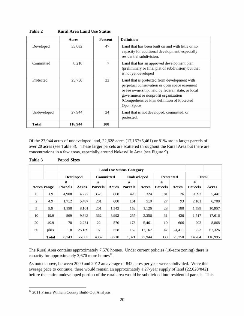
20
Table 2 Rural Area Land Use Status
Acres Percent Definition
Developed 55,082 47 Land that has been built on and with little or no capacity for additional development, especially residential subdivision.
Committed 8,218 7 Land that has an approved development plan (preliminary or final plat of subdivision) but that is not yet developed
Protected 25,750 22 Land that is protected from development with perpetual conservation or open space easement or fee ownership, held by federal, state, or local government or nonprofit organization (Comprehensive Plan definition of Protected Open Space
Undeveloped 27,944 24 Land that is not developed, committed, or protected.
Total 116,944 100
Of the 27,944 acres of undeveloped land, 22,628 acres (17,167+5,461) or 81% are in larger parcels of over 20 acres (see Table 3). These larger parcels are scattered throughout the Rural Area but there are concentrations in a few areas, especially around Nokesville Area (see Figure 9).
Table 3 Parcel Sizes
# Parcels Acres
# Parcels Acres
# Parcels Acres
# Parcels Acres
# Parcels Acres
0 1.9 4,908 4,222 3575 868 428 324 181 26 9,092 5,441
2 4.9 1,712 5,497 201 688 161 510 27 93 2,101 6,788
5 9.9 1,158 8,101 201 1,542 152 1,126 28 188 1,539 10,957
10 19.9 869 9,843 362 3,992 255 3,356 31 426 1,517 17,616
20 49.9 78 2,231 22 570 173 5,461 19 606 292 8,868
50 plus 18 25,189 6 558 152 17,167 47 24,411 223 67,326
Total 8,743 55,083 4367 8,218 1,321 27,944 333 25,750 14,764 116,995
Total
Land Use Status Category
Developed Committed
Acres range
Undeveloped Protected
The Rural Area contains approximately 7,570 homes. Under current policies (10-acre zoning) there is capacity for approximately 3,670 more homes12.
As noted above, between 2000 and 2012 an average of 842 acres per year were subdivided. Were this average pace to continue, there would remain an approximately a 27-year supply of land (22,628/842) before the entire undeveloped portion of the rural area would be subdivided into residential parcels. This
12 2011 Prince William County Build-Out Analysis.

21
27-year time frame is provided for context discussion only and is not based on a residential real estate market analysis.
5.3.3 Rezonings – land removed from Rural Area
The Rural Area Boundary has remained largely unchanged and the Rural Area itself has experienced a net reduction of less than 0.5 percent (454 acres) of the total land area as it was constituted in 1998. These changes are the result of four rezonings (The Reserve at Lake Manassas, Airport Gateway Commerce Center, Dominion Valley, and Avendale) that reduced the size of the rural area, and two rezonings (Van Buren and Villages of Piedmont II) that added land to the Rural Area
5.3.4 Cluster development
Few if any cluster developments have occurred in the Rural Area since 1998. Although permitted, the cluster development option is not attractive to developers (see below, Section 5.4). There are some current cluster developments in the Rural Area (e.g., Oak Valley see Figure 12 below), but their zoning appears to predate the 1998 Comprehensive Plan.
5.3.4 Family subdivisions
Family subdivisions are a small part of the development picture in the Rural Area. Between 2000 and 2012 there were 144 family conveyances covering 359 acres.

22
Figure 9 Undeveloped Land Parcels By Size

23
5.3.5 Marine Corps Base Quantico
Marine Corps Base Quantico (MCB Quantico) and surrounding counties began a Joint Land Use Study (JLUS) in 2013 aimed at identifying and ultimately controlling or minimizing land use and related factors that might affect the Base mission. One of these factors is incompatible land uses, especially within an approximately 3,000-foot area around Base. Work on the JLUS has identified some potential incompatibilities.
The JLUS has produced recommendations (draft December 2013) some of which are pertinent to the Rural Area. These include:
Pursue conservation partnering opportunities through the Readiness and Environmental Protection Integration (REPI) under DoD and through state, local and private conservation efforts (in collaboration with conservation partners) to pursue suitable properties for conservation in JLUS Military Influence Area Zone 1. (Figure 10).
REPI is a program that can be used to pay for up to half the cost of purchasing development rights on targeted properties around a base. Merrimac Farm is a 302-acre wildlife management area in the Rural Area on Deepwood Lane near MCB Quantico that was protected using REPI funds and through a partnership between MCB Quantico, the Virginia Dept. of Game & Inland Fisheries and the Prince William Conservation Alliance.
Pursue Transfer of Development Rights (TDR) and Purchase of Development Rights (PDR) programs for future land conservation purposes in the three JLUS counties and utilize the programs to transfer development potential out of JLUS Military Influence Area Zone 1.
Figure 10 MCB Quantico Military Influence Areas
Source: MCB Quantico Land Use Study Draft December 2013.

24
5.4 Observations
Prince William County’s Rural Area occupies an “edge” location between the more development-oriented areas to the north and east (eastern Prince William, Fairfax and Loudoun Counties) and the more rural areas to the west and south. Development policy in edge areas is always challenging because of pressures from the edges. Development policy in the Rural Area has consequences to the entire southern Washington D.C. metropolitan area.
As noted above, the Rural Area has capacity for approximately 3,670 more homes (under current policies). In a county of approximately 412,000 people this may not seem like a particularly large number but, under current policies, most of this additional development would be on 10-acre lots in current agricultural and forest/shrub lands. Were this to occur, it would change large parts of the Rural Area from a predominantly “rural” character area to a low density “suburban” character area. This would result in major changes to parts of the Rural Area that currently have strong rural character, and would be inconsistent with the general consensus we felt during the Study process around the desire and importance of maintaining a Rural Area. However, absent different options for rural properties and different planning policies by the County, the Rural Area will likely develop in a manner dominated by large lot residential development, with little contiguous open space and significant loss of agricultural lands.
5.4.1 Comprehensive Plan Amendments
Given the amount of development pressure in Prince William County, the net loss of only 454 acres since 1998 is striking. However, the pressure for change is strong as evidenced in the strong feelings expressed at Study meetings. Comprehensive Plan amendment and other development proposals that would result in rezonings have resulted in controversy and major public debates that have polarized people’s opinions (as seen in many of this Study’s survey results).
The Rural Area boundary has become the key policy for many supporters of the Rural Area. They feel, perhaps justifiably, that rezonings would undermine the principles that underlay the creation of the Rural Area and would result in accelerated conversion of rural land to development that would quickly erode the entire Rural Area concept.
This position does, however, have some negative consequences because the 10-acre zoning regulations do not require or encourage development design that minimizes impacts on rural character. The development of 10-acre lots on land that is surrounded by farms is not only visually obtrusive, but it undermines the long-term viability of farming. In other parts of the Rural Area, because of the way the Area evolved over time (see Section 2 above), there is land zoned for one dwelling per 10 acres that is unsuitable for this type of development because, for example, it is surrounded by one unit per acre development. If developed at higher density but with generous amounts of open space, such higher density development could contribute more to rural area environmental and open space policies than 10-acre lots.
Supporters of the Rural Area may acknowledge this but still oppose rezoning such properties for the reasons described above. This may appear to be counter to sound land use planning and development, but the position is understandable given that the Rural Area boundary line is, essentially, the only land preservation policy in place.
The key issue is that additional land preservation-supportive policies are lacking. With a more comprehensive set of Rural Area preservation policies in place, energy and attention could be directed to more effective long-term land preservation rather than to debating the location of a boundary line.

25
5.4.2 Cluster Development
The current cluster development regulations are not used for several reasons:
There is little developer incentive to cluster because the cluster option does not offer a density increase over the base 1 dwelling per 10 acre zoning.
There is a developer disincentive because cluster development has to go through the County’s development review process for approval. This can be time-consuming and expensive.
Cluster is easiest to accomplish with central sewer or with a package sewerage treatment plant or a shared community on-lot septic system. Opportunity to tap into sewer lines in the Rural Area is scarce.
Some counties such as Fauquier allow “alternate sewerage systems” (such as shared septic drainfields or mound systems) that can allow smaller lot sizes. Prince William County allows package sewer systems only if connected to public sewer, and each parcel is required to have its own on-site private (e.g., septic) system.
Soils in the Rural Crescent generally do not “percolate” well and so have limited ability to support on-site septic systems – especially multiple drainfields in close proximity or large, shared fields.
The market economics are not favorable: a 10-acre lot may currently sell for about $250,000. A three-acre lot might fetch $80,00013.
Cluster can play a role in helping to preserve land in the Rural Area and in contributing to rural character, but the cluster regulations would need to be revised.
5.4.3 Marine Corps Base Quantico
The Joint Land Use Study (JLUS) adds more impetus to preserving land that might create incompatibilities between off base land uses and the MCB Quantico’s military mission. The Military Influence Areas are limited in extent into the Rural Area (see Figure 10) and the 10-acre zoning is generally protective of the mission.
The REPI program is a preservation tool that can be used in the Military Influence Area as has been demonstrated in the preservation of Merrimac Farm.
5.5 Recommendations
5.5.1 Maintain the A-1 zoning density of one dwelling per ten acres, but create policy flexibility in locations where adjustments would advance the vision for the Rural Area.
There is much dissatisfaction with the present zoning but no clear consensus emerged for what to put in its place. Reducing the density to more restrictive zoning (such as one house per 20 acres or the sliding scale used in Fauquier County) would lower the number of potential new dwellings, but would be very unpopular among property owners. Rolling back the Comprehensive Plan mapping to pre-1998 conditions (thereby allowing increases in density through upzonings) would be a major policy reversal and would be very unpopular among supporters of the Rural Area.
In the survey for the Study, participants were asked their views on 10-acre lots. Among the respondents, 48 percent indicated it was a “reasonable balance between encouraging farming and allowing large-lot
13 Consultant estimates based on properties listed for sale during the study period and feedback at the stakeholder group meetings.

26
residential”; 61 percent said it was a good way to protect rural character; and 53 percent said it was a good way to protect the environment (Figure 11).
Figure 11 Opinions regarding 10-acre lot in the Rural Area
Question: The primary residential development pattern in the rural area is ten-acre lots. Do you think this approach to residential development is (check all that you think apply):
61%
53%
23%
48%
18%
13%16%
0%
10%
20%
30%
40%
50%
60%
70%
A good way toprotect ruralcharacter
A good way toprotect theenvironment
An inefficient useof rural land? (toosmall to farm, too
large for
residentialdevelopment)
A reasonablebalance betweenencouragingfarming and
allowing large‐lotresidential
Harmful tofarming (createsconflicts betweenfarmers and non‐
farming residents)
Too restrictive onresidential
development
Not protective oflandowners'
property rights
5.5.2 Revise and incentivize the cluster provisions of the A-1 zone
Two types of locations are good candidates for revisions: i) areas dominated by farming, and ii) areas dominated by higher density development
Areas dominated by farming (Valley Agriculture and Forestry rural character area)
In areas dominated by farming, clustering can allow for development that gives value to the landowner and, at the same time, the preservation of large amounts of open space that could be cropped, used for livestock or horses, or forested. To incentivize clustering, the permitted density could be increased from one dwelling per 10 acres to one dwelling per five acres. The open space requirement could be increased from the current 50 percent to 60 percent. Such cluster development would go through the development review process ensuring that its design meets the policy intent.
While clustering works best in areas with public sewer we do not recommend extending public sewer throughout the Rural Area, particularly to those areas dominated by farming, because accessibility to public sewer can allow for a scale of development that is more intense than that which is appropriate for the rural character and economy of the Rural Area. Extensions of public sewer in the Rural Area should be limited and targeted to achieve the strategic outcomes identified in this Study.

27
Extension of sewer throughout the Rural Area would be counter to the Comprehensive Plan’s intent with respect to sprawl:
Designation of the Rural Area and application of the development goals, policies, and action strategies for it are intended to help avoid the negative economic, social, and environmental characteristics of sprawl development (Comprehensive Plan, Intro-3).
Areas dominated by higher density development
Several parts of the Rural Area are dominated by development at a density higher than one dwelling per 10 acres. This is due in large part to the planning history of the Rural Area – see Section 2 above. When the Rural Area boundary was created in 1998, it included some areas that had been developed at higher density (including some areas on public sewer) or were zoned for higher density and were grandfathered.
Section 6, below, describes these “Rural Character” areas (#10 - Older, Smaller-Lot Residential Enclaves, #3 Valley Estates and Subdivisions and # 6 the Transitional Ribbon). Some of these areas are adjacent to the Comprehensive Plan’s Development Area.
Cluster development could work well in these areas. It could be more compatible with existing development, and more protective of environmental resources and rural character compared to 10-acre lots (see Figure 12). For example, in the Transitional Ribbon, the development part of the cluster could be placed across from existing developed areas and the open space be placed adjacent to the Rural Area, thereby creating an effective transition from the Developed Area to the Rural Area. Such open space could be protected by easement to ensure permanent preservation. Some counties require non-governmental easement co-holders as a further assurance of permanent preservation.
In these areas limited extensions of public sewer could be allowed. Public sewer would allow maximum flexibility in lot size and placement and the maximum amount of open space. Rather than opening up the Rural Area to development, such limited extensions would create a firmer, better-defined, long term edge to the Rural Area compared to the current patchwork. This would help the County meet both its rural preservation goals and its urban development goals. We recommend consideration be given to a maximum gross density of one unit per two to three acres and a minimum 50 percent open space requirement.
Not every property in these areas would be suitable for public sewer. Each sewer extension request should be reviewed on a case by case basis to consider whether it would further the vision and policies for the Rural Area.
In return for the increased density that would occur on properties in these areas developers could purchase PDRs or proffer funds to help support the PDR program. These properties could also be TDR receiving areas (see Section 4.5.2, above).
5.5.3 Implement the recommendations of the MCB Quantico Joint Land Use Study
These include pursuing conservation partnering opportunities through the Readiness and Environmental Protection Integration (REPI) and other conservation efforts, and pursuing Transfer of Development Rights (TDR) and Purchase of Development Rights (PDR) programs.

28
Figure 12 Cluster and Non-Cluster Development, Case Study from the Rural Area
Source: Rural Character Areas presentation Open House Sessions, December 7, 2013.
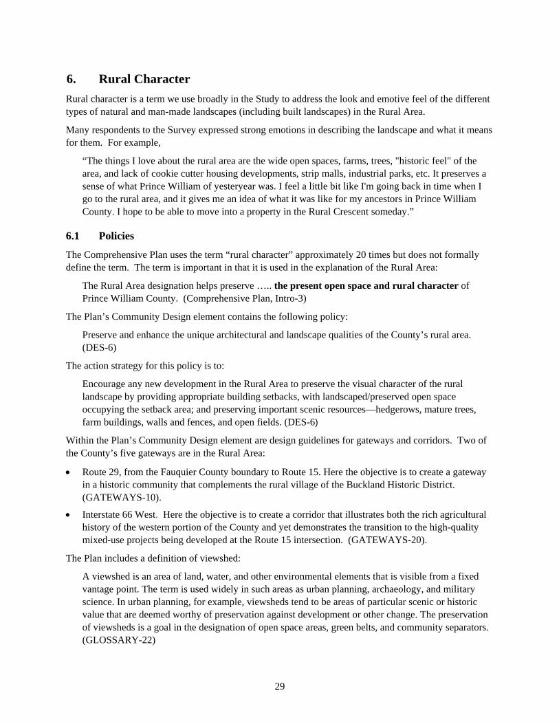
29
6. Rural Character
Rural character is a term we use broadly in the Study to address the look and emotive feel of the different types of natural and man-made landscapes (including built landscapes) in the Rural Area.
Many respondents to the Survey expressed strong emotions in describing the landscape and what it means for them. For example,
“The things I love about the rural area are the wide open spaces, farms, trees, "historic feel" of the area, and lack of cookie cutter housing developments, strip malls, industrial parks, etc. It preserves a sense of what Prince William of yesteryear was. I feel a little bit like I'm going back in time when I go to the rural area, and it gives me an idea of what it was like for my ancestors in Prince William County. I hope to be able to move into a property in the Rural Crescent someday.”
6.1 Policies
The Comprehensive Plan uses the term “rural character” approximately 20 times but does not formally define the term. The term is important in that it is used in the explanation of the Rural Area:
The Rural Area designation helps preserve ….. the present open space and rural character of Prince William County. (Comprehensive Plan, Intro-3)
The Plan’s Community Design element contains the following policy:
Preserve and enhance the unique architectural and landscape qualities of the County’s rural area. (DES-6)
The action strategy for this policy is to:
Encourage any new development in the Rural Area to preserve the visual character of the rural landscape by providing appropriate building setbacks, with landscaped/preserved open space occupying the setback area; and preserving important scenic resources—hedgerows, mature trees, farm buildings, walls and fences, and open fields. (DES-6)
Within the Plan’s Community Design element are design guidelines for gateways and corridors. Two of the County’s five gateways are in the Rural Area:
Route 29, from the Fauquier County boundary to Route 15. Here the objective is to create a gateway in a historic community that complements the rural village of the Buckland Historic District. (GATEWAYS-10).
Interstate 66 West. Here the objective is to create a corridor that illustrates both the rich agricultural history of the western portion of the County and yet demonstrates the transition to the high-quality mixed-use projects being developed at the Route 15 intersection. (GATEWAYS-20).
The Plan includes a definition of viewshed:
A viewshed is an area of land, water, and other environmental elements that is visible from a fixed vantage point. The term is used widely in such areas as urban planning, archaeology, and military science. In urban planning, for example, viewsheds tend to be areas of particular scenic or historic value that are deemed worthy of preservation against development or other change. The preservation of viewsheds is a goal in the designation of open space areas, green belts, and community separators. (GLOSSARY-22)

30
6.2 Issues/concerns
Generally, participants in the public input process expressed more concern over “development” than over loss of rural character. However since development impacts the landscape, most of the issues listed above in Section 5.2 are equally applicable to rural character.
The Planning Office notes that 10-acre subdivisions can be created by deed. As a result they do not go through the development review process that would allow staff the opportunity to improve the subdivision design layout, including land preservation. Achieving the Comprehensive Plan’s rural character design policies is currently largely unachievable because most development will occur outside of a development review process that provides the mechanisms to achieve the policies. Figure 12 above shows the differential results on the landscape of a 10-acre versus a cluster subdivision.
The Study survey asked some questions directly and indirectly about rural character:
When participants were asked to indicate their opinion about what the Rural Area meant to them among the top three responses was “a place to enhance rural character” (see Figure 2 above).
Survey question 12 was titled “Preserving and Enhancing Rural Character” It described various site design, landscape architectural, and architectural techniques that can help preserve and/or enhance the character of a rural landscape (such as building setbacks from property lines, building placement on the property, and fence material and style). It then asked respondents the extent they would support more or less county control over these techniques. Fairly strong majorities (60 to 70%) indicated no support for change to current controls.
The only technique with a majority opinion supporting more control was “public road design”.
In the open response section of the survey a number of respondents indicate concern over what they viewed as excessive lighting at public facilities in the Rural Area.
See Appendix 1 for the full survey results.
6.3 Trends
Little meaningful data exists regarding rural character and the extent to which county policies are being achieved.
Landscapes do change over time but landscapes are complex and change tends to be gradual making it hard to pinpoint when a landscape underwent fundamental change. In addition the rural character concept itself is hard to define objectively making it difficult to measure trends.
Partly in response to this difficulty, as a component of the Study we conducted a landscape-level documentation and visual assessment of what the Rural Area actually looks like today. We describe this assessment in the following section.

31
6.4 Observations
Rural character means a landscape dominated by or with a strong presence of rural elements. We list these elements in Prince William County in Table 4. Some elements, such as churches or elevation changes, are not exclusively rural, but, in combination with other elements, can contribute to the sense and feeling of being in a rural area.
Table 4 Rural Character Elements
Buildings/ signage that refer to “rural” activities (e.g., churches, hunting, golf, farms),
Commercial buildings that refer to “rural” business (e.g., nurseries, country stores, farm to table restaurants)
Dwellings that fit into the landscape, (versus being the dominant element)
Elevation changes, topography (rural in combination with other rural elements
Farms – cropland, managed;
Farm animals, cattle, horses, goats;
Farm buildings (e.g., barns, silos);
Fencing that is open (typically of wood)
Historical references (sites, markers, architecture)
Lighting that is low or muted
Open as opposed to closed views (urban areas are characterized by a greater sense of closure)
Open space;
Parks (though this depends on the park design/elements)
“Rural” roads (scenic, 2-lane, winding, undulating)
Streams
Views/vistas;
Woods/forested areas
Absence of “urban elements” –(e.g., large, modern buildings);
To understand and document what Prince William County’s Rural Area is actually like and how it differs in different parts, we reviewed aerial photography, reviewed maps showing land use, property parcel patterns and sizes, environmental resources and vegetation patterns, topography, views and vistas, dedicated open spaces and recreation, agricultural/ forested areas, undeveloped lands, and road types. We also toured and photo-documented the area taking over 1,300 photographs.
Overall, based on our field work and analysis, we conclude that the Rural Area is “rural”, meaning that the Rural Area in its entirety includes the rural elements listed above. However the Rural Area has different sub-areas within it, based on the extent to which some elements are stronger or more dominant in the landscape compared to others; the Rural Area feels different, for example, near Quantico and Prince William Forest Park compared to Nokesville or to the Bull Run Mountainside. In this Study we call these sub-areas “rural character areas”, which we define as follows:
Recognizable geographic areas that share like characteristics and evoke a unique and different feeling through their natural and man-made elements and surroundings.
We identify 10 rural character areas each one recognizable for its shared characteristics (see Figure 13)

32
Figure 13 Rural Character Areas (Preliminary Proposed)
1. Rural Gateway Corridors
2. Bull Run Mountainside
3. Stream Valley Estates and Subdivisions
4. Valley Agriculture and Forests
5. Crossroad Commercial Areas
6. Transitional Ribbon(s)
7. Nokesville Village
8. Mixed-Use Hamlets
9. Protected Lands, Public Lands/Facilities & Organized Recreation Parks/Golf Course
10. Older, Smaller-Lot Residential Enclaves

33
As an example of shared characteristics, rural character area #4, Valley Agriculture and Forestry, has (in summary) the following characteristics (Figure 14):
Active and fallow farming and forestal areas,
Adjacent undeveloped lands,
Open vistas to Bull Run Mountain, Manassas Battlefield, valley stream corridors,
Scenic farm buildings/complexes.
Figure 14 Valley Agriculture and Forestry Character
Source: Rural Character Areas presentation Open House Sessions, December 7, 2013
34
As another example, the “Valley Estates and Subdivisions” character area has (in summary) the following characteristics (Figure 15)
Existing mix of individual homes/or committed building lots and organized subdivisions,
Range of lot sizes depending on zoning/subdivision requirements when built,
Existing suburban densities of 0.5 to 3 acre lots in many areas,
Road widening beyond rural standards,
Located in areas with mostly improved roads and nearby access to existing commuter routes
Figure 15 Valley Estates and Subdivisions Character
Source: Rural Character Areas presentation Open House Sessions, December 7, 2013

35
The “Transitional Ribbon” is an important character area. It is a linear area of land use transition between the Rural Area and the Development Area. It follows frontage roads and streams that in some cases could create future conflict between rural area character quality and Development Area goals.
As noted in Section 5, development policy in edge areas is always challenging because of pressures from the edges.
The Transitional Ribbon North has edge conditions and a mix of uses along the Manassas Battlefield, the West Haymarket area, Rte. 215/Vint Hill Rd, Bristow Road, Manassas Airport, and the south side of Lake Manassas.
The Transitional Ribbon South is primarily composed of the Prince William Forest Park fringe. It has relatively small pieces of land many of which are already developed.
Please see Appendix 5 for a detailed description of rural character and each of the rural character areas presented in Powerpoint form at the Public Open House Sessions on December 7, 2013. The character areas presentations were well received at the sessions and several participants noted that it was the first time they had seen documentation that illustrated their intuitive sense that the landscape of the Rural Area varied considerably and should not be treated in a one-size fits all manner.
Preserving and enhancing the different rural character in the different areas to achieve desired outcomes will require more pre-emptive planning and management, including using a broader range of planning and preservation tools, than currently occurs.
6.5 Recommendations
6.5.1 Recognize rural character areas. Refine/verify the rural character area map developed for this Study and adopt the map into the Comprehensive Plan.
6.5.2 Use the character areas as the basis for policies that protect and/or enhance the character in the different areas. Examples:
Allow selective public sewer extensions in the Transitional Ribbon into Older, Smaller-Lot Residential Enclaves and Valley Estates and Subdivisions.

36
Not every parcel in these character areas is suitable for public sewer. Such extensions should be allowed only by the Board of County Supervisors when justified, and on a case by case basis.
TDRs, PDRs, and/or conservation easements should be required in return for any density increase that results from extension of sewer.
Criteria for consideration in approving sewer extensions would include:
- Impacts on adjoining/nearby parcels,
- Impacts on adjoining/nearby character areas,
- Development design, especially the amount and location of open space and its contribution to the Rural Area, especially farming.
Allow cluster development in Valley Agriculture and Forest areas (one dwelling unit per 5 acres, not on public sewer). (See above Section 5.5)
Apply roadway design standards more carefully to protect and/or enhance the character in different character areas. There was strong support for this in the survey. For example, avoid road widenings (acceleration/deceleration lanes) in the Valley Agriculture and Forest areas.
Adopt site design, landscape architectural, and architectural techniques to help preserve and/or enhance the character of selected character areas. Overall there was not strong support for this in the survey, but there may be support in selected character areas.
6.5.3 Use the rural character areas as the basis for prioritizing land preservation through PDR and TDR.
Priority areas would be: Rural Gateway Corridors, Valley Agriculture and Forests, and land adjacent to existing protected lands.
6.5.4 Use the rural character areas in selecting/screening sites for public facilities
For example, avoid locating schools or sports complexes in Rural Gateway Corridors or Valley Agriculture and Forests character areas.
7. Sewer and Water
7.1 Policies
Sewer and water policy is an important component of land use and preservation planning. As described in Section 1, sewer policy helps define the Rural Area. The key policy statement is in the Comprehensive Plan’s introduction:
The Rural Area may be served by public water facilities but not by public sewer facilities, except under the emergency conditions identified in the Sewer Plan or to serve specific public facilities (Comp Plan, Intro-3).
Supporting policies in the water and sewer elements are as follows:
Extension of public water shall not be used as a justification for increasing the residential densities that are shown on the Long-Range Land Use Plan Map for a given area (Water-1)
Prohibit the extension of public sewer into the Rural Area, except under special circumstances that maintain the land use densities delineated in the Long-Range Land Use Plan Map and uphold the policies and action strategies outlined in the Comprehensive Plan. (Sewer-4)

37
13 action strategies are intended to implement this policy. For example:
All new development within the Rural Area shall be served by individual-lot, on-site sewerage systems. Public sewer systems – except under….. special circumstances … shall not be extended into the Rural Area.
Permit the voluntary use of public sewer systems for existing structures in a sub-watershed that has a documented history of sewerage system failures, as determined by the Health Department.
The existence or extension of a public sewer system in the Rural Area shall not provide justification for altering the land use classifications on the Long-Range Land Use Plan.
To serve a public facility, such as a public school, fire station, or public library, allow for the extension of public sewer into the Rural Area.
7.2 Issues/concerns
Much public input to the Study concerned sewer policy. Contrasting views were expressed ranging from support for the current policy to recommendations to extend public sewer to all or much of the Rural Area. Additional views were that:
The soils in the Rural Area are not suitable for septic drain fields,
Many areas have septic drain fields that are failing,
Public sewer is less harmful to the environment compared to septic systems,
Extending public sewer would allow effective cluster development that would result in larger, contiguous open space areas that could be used for farming.
Question 7 of the Survey addressed sewer, asking respondents views on five questions. The results indicated approximately 60% versus 40% support for the current policies. Responses to a question as to whether the County should allow sewer in parts of the Rural Area that have very little rural character were split roughly 50-50 agree/disagree (See Appendix 1 for the full results).
7.3 Trends
7.3.1 Existing areas with sewer
There are some areas with public sewer in the Rural Area but they are very limited in extent. Four areas have sewer (Figure 16 ):
Nokesville: Nokesville had a wastewater treatment plant until the early 2000s but wastewater from Nokesville is now pumped to east side of the County. The Nokesville sewerage system has very limited capacity to provide service to properties outside the planned service area identified in the Nokesville Sector Plan.
Joplin Road (near Bristow Road). This area is near the County landfill on Dumfries Road, and is on the edge of the Rural Area.
Roland Park Place. This area is on Rt 15 near Rt 29 on the edge of the Rural Area.
Catharpin Road and Sudley Road. These areas are inside the Rural Area but have Suburban Residential (SR) zoning (that predates creation of the Rural Area.
Figure 16 also shows areas with public water.

38
Figure 16 Water and Sewer

39
7.3.2 Septic systems
The Prince William Health District does not have records of areas with large numbers of failing septic systems in the Rural Area14. However, cases of individual failing systems do come to the District’s attention. The District works with the property owner to install a system that does not create health concerns. Such systems are issued a “small discharge permit”. The Rural Area has approximately 120 such permits, and the Department issues approximately five new permits per year.
7.4 Observations
Sewer policy is an important component of rural preservation. Extending sewer to large parts of the Rural Area would be inconsistent with the current Comprehensive Plan’s overall vision for the Rural Area. Accessibility to public sewer can allow for a scale of development that is more intense than that which is appropriate for the Rural Area. Extensions of public sewer in the Rural Area should be limited and targeted to achieve the strategic outcomes identified in this Study. Extension of public sewer outside of the limits recommended in this Study could facilitate a scale of development that would be incompatible with the goals of the Comprehensive Plan and would increase demand for public facilities. Where septic systems are failing and public sewer is available, such as in Nokesville, it may make sense to allow hook up to sewer rather than install a small discharge system.
Public sewer can facilitate cluster development and creation of large open space areas, but such cluster developments need to be carefully located in relation to the larger landscape. Cluster developments on sewer across large parts of the Rural Area would not create an area that, overall, would feel “rural” as we define it in Section 6.
With respect to nitrogen pollution from wastewater, development on sewer is generally less harmful to the environment compared to septic systems because the wastewater from thousands of homes and businesses is treated at a wastewater treatment plant. However, there are offsetting considerations. Land served by sewer can generally accommodate higher densities and, as such, development on sewer may result in greater overall impacts to the environment when considering the larger amount of runoff from increased impervious areas as well as impacts associated with the increased number of vehicle trips from the larger number of homes
While large numbers of septic systems are not desirable from an environmental perspective, the current 10-acre minimum lot size does allow a “cushion” for septic systems in that such large lots provide more land for dissipating environmental effects compared to smaller sized lots (such as one or three acre lots).
7.5 Recommendations
7.5.1 Allow extensions of public sewer on a case by case basis in the following rural character areas in the Transitional Ribbon, #10 - Older, Smaller-Lot Residential Enclaves; and #3 Valley Estates and Subdivisions.
See additional detail above in Section 5.5.2 (Land Use and Development).
7.5.2 Allow hookups to public sewer on a case by case basis to individual properties where septic systems are failing and public sewer is readily available, such as in Nokesville. 7.5.3 Retain the other Rural Area sewer and water policies.
14 Discussions with Marcus Haynes, Senior Environmental Health Specialist, Virginia Department of Health.

40
8. Environmental Protection
8.1 Policies
The Comprehensive Plan’s Environment element contains countywide policies – not policies that are specific to the Rural Area. The element’s goal is to:
Preserve, protect, and enhance the significant environmental resources and features of the County including air quality, topography, soils, ground and surface water, biotic communities (stream corridors, forests, and wetlands), sensitive plant and animal species, and natural viewsheds.
Environmental resources are defined to include:
All 100-year floodplains as determined by the Federal Emergency Management Agency (FEMA), Flood Hazard Use Maps or natural 100-year floodplains …. and Resource Protection Areas as defined by the Chesapeake Bay Preservation Act. (LU 31)
Some policies are of specific relevance to rural preservation. For example, EN-POLICY 3 states:
To further support OS‐Policy 5, a minimum of 39 percent of the total area in the County exclusive of acreage of Marine Corps Base Quantico for all calculation purposes, should be retained as protected open space, as defined in the Open Space Plan. (ENV-4)
A number of action strategies are intended to implement this policy. For example (ENV- 4,5):
encourage cluster development to protect contiguous natural open space,
make information on conservation easements available to landowners,
review and implement opportunities for a Purchase of Development Rights (PDR) program,
initiate and provide public information programs aimed at conserving lands in the watershed,
establish a Countywide trails and corridors system,
identify and prioritize a network of preservation corridors or large woodland areas to be incorporated into an overall habitat protection network .
Environment Policy 9 states:
Ensure the high quality of public drinking water sources.
A number of action strategies are intended to implement this policy. For example (ENV-12, 13):
encourage conservation of natural features and limit impervious surfaces in areas where groundwater is the water supply,
develop procedures to protect or improve, if necessary, the quality of groundwater in areas where groundwater is the water supply,
amend the Zoning Ordinance to develop a Drinking Water Reservoir Protection Overlay District.
The Comprehensive Plan’s Land Use element’s policy 12 is relevant:
Encourage a land use pattern that respects environmental features in accordance with the goals and objectives of the Environment Plan. (LU-14)
A number of action strategies are intended to implement this policy. For example:

41
Ensure that the primary function of the Rural Area as reflected by the Long-Range Land Use Plan Map is to maintain open space, protect native habitats, allow for large-lot residential development, allow for agricultural activities, and provide potential sites for community facilities.
8.2 Issues/concerns
In the survey conducted for this study when participants were asked to indicate their opinion about what the Rural Area meant to them, the top response was “a place to emphasize environmental protection.
While this Study’s focus is on preservation some specific environmental concerns that were raised in the public outreach for the Study were:
Total Maximum Daily Load. Prince William County is in the Chesapeake Bay watershed and is subject to the Chesapeake Bay Total Maximum Daily Load (TMDL) – popularly known as the “pollution diet”.
Groundwater and water supply. Human activity in the Rural Area affects streams and groundwater which in turn affects the Occoquan water supply reservoir.
Green Infrastructure. Desire for interconnectivity between environmental and open space resources to create connected corridors of protected land, including connectivity between the Development Area and the Rural Area.
8.3 Trends
The Clean Water Act establishes Total Maximum Daily Load (TMDL) regulations for waterbodies that do not meet the numeric standards for fishable and swimmable water. The number of listed streams in the County has grown each year from 44 streams in 2004 to 60 in 2006. The county has started to address this stream degradation with a baseline stream assessment. TMDL requirements and anticipated Virginia Storm Water Management Permit mandates may soon require expanded programs to address deficiencies (Prince William County Strategic Plan, 2012).
The Chesapeake Bay now has a TMDL. According to the Virginia Assessment Scenario Tool (VAST) model, the County expects to meet the TMDL for all sectors in 2025. However, changes in county land use as well as in Chesapeake Bay Program goals will undoubtedly impact this in the future15.
Fairfax County Water Authority (Fairfax Water) manages the Occoquan Reservoir as a water supply impoundment. The Rural Area makes up approximately 20% of the Occoquan watershed and Fairfax Water has a Source Water Planning and Protection office that monitors water management issues.
Also of note is the Northern Virginia Regional Water Supply Plan which follows the State Water Control Board’s regulations for Water Supply Planning. The major sections in the Plan include information on water sources, water use, and natural resources in the region.
8.4 Observations
This Study’s focus is on land preservation and larger environmental issues such as the Chesapeake Bay TMDL and public water supply are beyond the Study scope. However, in thinking about preservation environmental considerations were also considered.
The Comprehensive Plan’s environmental policies address the broad range of environmental resources. This Rural Preservation Study makes recommendations for several of the action strategies that have not
15 Discussions with Department of Public Works, Environmental Services Division

42
been implemented such as cluster development, purchase of development rights, and creation of interconnected open space corridors. Implementing these would benefit the environment, through for example, environmental site design that would provide more opportunities to reduce impervious surface from development and the associated stormwater runoff, and to preserve land that can be used for increasing forest cover, especially along streams.
Other action strategies will need to be addressed more directly as the County works to comply with TMDL requirements including the Chesapeake Bay TMDL.
As discussed above in Section 7, sewer policy is key to preserving the Rural Area. While development on sewer is generally less harmful to the environment compared to septic systems, the offsetting considerations are the impacts to the environment from the larger amounts of impervious surface that results from development that can be accommodated by sewer. This Study’s land use and development and rural character recommendations seek to balance these offsetting impacts.
8.5 Recommendations
8.5.1 Implement this Study’s recommendations that will have direct environmental benefits especially those related to land preservation, sewer, and open space corridor creation.
8.5.2 Consider this Study’s recommendations in tandem with the County’s efforts to comply with TMDL requirements including the Chesapeake Bay TMDL
9. Open Space and Recreation
9.1 Policies
The Comprehensive Plan defines Open Space broadly:
Land that is not dominated by man-made structures. It preserves natural or cultural resources, provides for passive recreation, is used for cultivated fields or forests, or exists in a natural and undeveloped state. Open space may include nature preserves, historic sites, farms, parks, forests, floodplains, wetlands, etc., and may include some structures, parking areas, roads, trails and facilities that support the use of the land. (POS&T-24)
Protected Open Space is defined as:
Land that is protected from development with perpetual conservation or open space easement or fee ownership, held by federal, state, or local government or nonprofit organization for natural resource, forestry, agriculture, wildlife, recreation, historic, cultural, or open space use, or to sustain water quality and living resources values.
The Plan sets an aggressive goal to retain a minimum of 39 percent of the total area in the County, (excluding MCB Quantico) as protected open space. (POS&T-26).
Other policies of interest include: (See Figure 17)
Corridors goal: Identify, protect and preserve environmental, heritage, and recreational corridors. (POS&T-27)
Trails Goal 2: Plan and implement a comprehensive countywide network of trails. (POS&T-31)
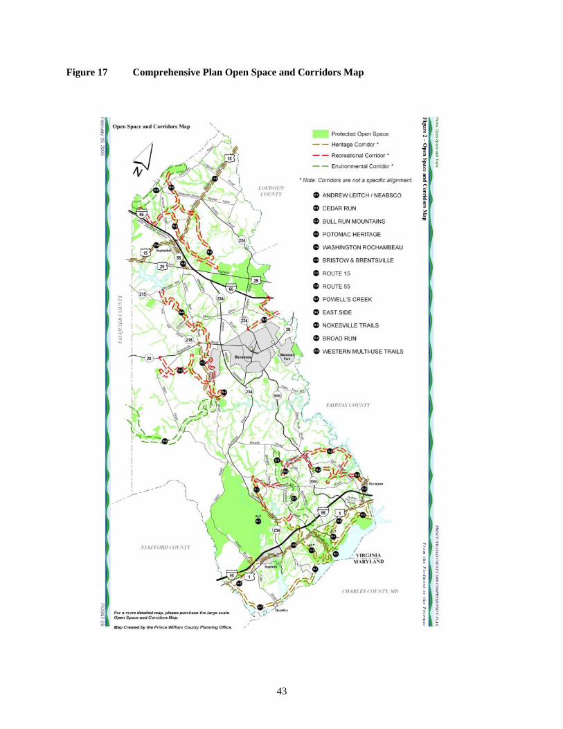
43
Figure 17 Comprehensive Plan Open Space and Corridors Map

44
9.2 Issues/concerns
Some participants in the public input process questioned and wanted more details regarding how the County calculates its protected open space acreages.
Many participants in the survey expressed concern over the appropriateness of locating sports complexes in the Rural Area. Participants drew a distinction between parks (widely viewed as appropriate) and sports complexes (widely viewed as inappropriate) – see Figure 18.
Figure 18 Opinions Regarding Public Facilities
Please indicate your opinion on whether the following public facilities are appropriate for the Rural Area:
248
115
285
207
191
297
53
51
157
16
66
67
12
202
0 100 200 300 400
Public schools
Sports complexes
Emergency services (fire, police,EMS)
Libraries
Private or non‐profit civic orcommunity uses such as camps or
schools.
Parks
Government offices
Strongly Agree + Agree
Strongly Disagree + Disagree

45
9.3 Trends
Countywide, as of 2013, approximately 40,200 acres are protected (see Table 5). Of these approximately 25,750 acres are in the Rural Area (see Table 1 above for a breakdown). The County’s 39% Protected Open Space goal is approximately 79,250 acres so that approximately 39,000 additional acres are needed to meet the goal.
Table 5 Protected Open Space
Acres SourceCounty total 227,314 Developed area 110,320 from 2011 Build out analysis.
Rural Area 116,994 from Rural Preservation Study acreage analysis
Quantico 24,079 Rural Preservation Study acreage analysisSubtotal 203,235 Calculation (County total minus Quantico)39% goal 79,262 Calculation 203,235*0.39Protected Countywide 40,229 2011 Build out analysis.
Protected Rural Area 25,750 Rural Preservation Study acreage analysisProtected Development Area 14,479 Calculation 40,229-25,750
Percent protected 20% Calculation 40,229/203,235Acres needed to reach goal 39,033 Calculation: 79,262-40,229
There is much interest in green infrastructure, corridor and trail planning in, for example, the Northern Virginia Regional Commission Conservation Corridor Planning, and the Virginia Department of Conservation and Recreation’s Virginia Outdoors Plan.
9.4 Observations
Achieving the County’s 39% protected open space goal will be major challenge. Approximately 27,944 acres (24%) of the Rural Area remain undeveloped (see Table 1). A very aggressive goal would be to protect 60 percent of this – equivalent to approximately 17,000 acres. When added to the 25,750 existing protected acres, the total would be 42,500 acres (approximately 36% of the entire Rural Area).
Extensive areas of large lot (10-acre plus) development limit the ability to create large contiguous areas of open space that are particularly important for wildlife habitat. Conversely areas that are largely free of development including carefully designed cluster development can support wildlife habitat and bio-diversity. These points were discussed at stakeholder meetings by the Virginia Department of Conservation and Recreation and by the Virginia Outdoor Foundation.
The Comprehensive Plan’s Open Space and Corridors Map is a forward-looking map combining environmental, recreation, and heritage considerations into a unified open space vision. A lot of work is being done on pieces of this type of vision by different organizations, groups, and individuals. For example Figure 19 shows an environmentally oriented corridors map by the Northern Virginia Regional Commission.
Several people working on trail development participated in meetings for this Study and there appears to be much local interest in trail development.

46
Figure 19 Conservation Corridors
Source: Northern Virginia Regional Commission (NVRC)’s Conservation Corridor Planning (2012)

47
9.5 Recommendations
9.5.1 Consider a goal to protect 60 percent of the remaining undeveloped land in the Rural Area – equivalent to approximately 17,000 acres.
Protection would come from a combination of a variety of sources and programs including PDR, TDR, park acquisition, federal and state acquisitions and funding support, easement donations, REPI, and open space in cluster subdivisions.
9.5.2 Refine the Comprehensive Plan’s Open Space and Corridors map into a detailed, unified, interconnected open space vision suitable as the basis for specific implementation projects including land preservation and trail development.
Incorporate environmental, recreation, and heritage considerations.
Include consideration of related efforts such as the:
- Northern Virginia Regional Commission Conservation Corridor Project mapping,
- Virginia Department of Conservation and Recreation’s Virginia Outdoors Plan,
- Journey Through Hallowed Ground Scenic Byway corridor management plan,
- Rural Preservation Study’s rural character area mapping.
10. Economic Development
10.1 Policies
The Comprehensive Plan’s Economic Development element is focused on enhancement and diversification of Prince William County's revenue base and growth. It does not contain policies specific to the Rural Area. However a component of the overall vision for the Rural Area is to “help preserve the County’s agricultural economy and resources” (see Section 3.1 above).
10.2 Issues/concerns
Much of the public input part of the study was devoted to the discussion of the future of agriculture in Prince William County. There were a variety of opinions and views; these are described in Section 4.2 above, and to avoid duplication are not repeated here.
The County Planning Office noted some difficulties in applying/interpreting the current zoning regulations with respect to determining the types of business that would come under the definition of agricultural use or a use accessory to agriculture. The term agribusiness, for example is not used in the zoning ordinance.
10.3 Trends
10.3.1 Agriculture
From a purely economic perspective the prospects for farming in Prince William County have not looked good. In both the 2002 and the 2007 Census of Agriculture, total farm production expenses exceeded gross sales, indicating a net financial loss. In 2002, farm production expenses were $10.95 million and gross sales were $9.521 million. In 2007, farm production expenses were $15.752 million and the market value of agricultural products sold was $9.43 million. Of the 350 farms in the County in 2002, 163 showed gross sales of less than $2,500. In 2007, of the County’s 345 farms, 181 had gross sales of less

48
than $2,500. In other words, farming lost money in both 2002 and 2007, and about half of the farms produced negligible sales. Caveats to this are as follows:
The 2012 Census data are expected to be released in May 2014, and may show an increase or decrease in agricultural activity.
The largest 3 farms in the County accounted for $5.5 million in total sales, or nearly 60%.
The Census data do not include the value of horse industry.
The Census data do not include very small farms, such as hobby or specialty farms. While these would not make a large difference to the overall economic results, we know from the input to the Study that the interest trend in such farms is increasing and that they do make an important contribution to rural character in Prince William County.
While the public input process yielded much pessimism about the future of agriculture in the County, there was also some optimism. Some farms are committed to farming, for example Evergreen Acres, Windy Knoll Farm (Nokesville) and Yankey Farms. The County has a winery (The Winery at La Grange). The farm bureau has 300 registered producers in Prince William and Fairfax Counties.
Trends in the amount of agricultural land in the County are described above in Section 4.3.
10.3.2 Recreation
We know from the Study survey and from the public meetings that Prince William County residents value and use the Rural Area as a recreation resource (see Figure 2 above). Activities include bicycling, hunting clubs, golf, parks (Prince William Forest, Manassas Battlefield, Silver Lake Regional), nature viewing, and cultural/historic-related activities.
Large numbers of people visit parks in the Rural Area (Table 6). However, no composite recreation economic data specific to the Rural Area exist and how much money recreationists spend in the Rural Area is not known.
Table 6 Annual Park Visitation
Prince William Forest Park Manassas Battlefield Park
2011 379,535 659,740
2012 280,325 600,354
Source: National Park Service
10.3.3 Other Economic Activity
Other economic activity in the Rural Area includes:
Marine Corps Base Quantico with its weekday population of approximately 28,000, including marine corps, the Military Defense Investigative Agencies (MDIA), FBI/Drug Enforcement, dependents and contractors. MCB Quantico’s economic impact is broad and not limited to the Rural Area.
Nokesville; the Rural Area’s “rural center”.
Scattered crossroads commercial, retail nurseries (B-1 zoning).
Home businesses, including home employment, rural home businesses.
Forestry (limited value; value of forest production: $350,000, according to Virginia Tech, 2010).

49
10.3.4 Public Input into Businesses Suitable for the Rural Area
Survey question # 22 was open ended and asked, “Besides farming, what types of business development do you think are appropriate in the rural area to support the rural economy?” The question received a good deal of input and varying perspectives (see Appendix 1 for the full results). A selection of responses, as presented at the December workshop, follows:
General support for businesses supporting/related to farms, recreation environment, cultural/historic. Small business, including home-based: Not large or “heavy” industry.
Some responses that would favor a broader suite of businesses.
Some respondents said “none” i.e., no more businesses.
Alternative energy sources, i.e. wind farms or solar energy plants.
Nurseries, small stores (general), occasional gas stations, antique shops.
Agricultural and equestrian related activities. NOT the landfill-like operations we are currently seeing taking place!
I do not think "commercial business development" should be allowed in the Rural Crescent. However, farms are businesses. Vineyards are businesses. Raising and training horses is a business.
One thing I think the county could do much better is to utilize the rural area to encourage farming and then to use that industry to sell in its own area. In other words, we should support our local farmers by helping and encouraging their production and then selling their produce locally through strategically placed stores (designed to fit in a rural setting).
Non-manufacturing jobs such as IT and R&D would help alleviate some of the traffic on 66 and possibly 95. These higher wage jobs would be necessary for the desired types of housing developments. A high end shopping mall near the rural area (Gainesville maybe) would be a great addition.
Home businesses and home schooling should be encouraged in every way possible. Having more people staying in neighborhoods during the day increases safety and decreases demand on the roads.
There is no need for business development in the rural area. The BEAUTY of the rural crescent is that it is close enough to large industry and already established businesses that there is no need for more to support the "rural economy".
Nokesville has a strong horse community - leverage it with trails throughout and otherwise make it a closer in Middleburg (Note: you have hunters/jumpers and trail riders when it comes to horse people so segmentation is very possible). Other areas may have aquatics - rowing, canoeing, fishing, diving etc.
10.4 Observations
Economy activity is important to rural areas, so that they are working landscapes and not just open space. A vibrant rural economy can help preserve land in that landowners value the land for its intrinsic economic and productivity value and not only as potential future residential development.
While agriculture is a key component of rural economic development, and is particularly important to the rural landscape and rural character, the overall rural economy is larger and should be understood broadly and in an integrated manner to include recreation, tourism, and other types of economic activity.
The Rural Area makes a valuable contribution to Prince William County’s countywide, quality of life and economic development. Research has shown clearly that businesses making location decisions consider

50
in part their employees’ quality of life, and easy access to an attractive, rural area and open space is an important (though not the only) contributor to quality of life. Therefore, land preservation in the Rural Area has broad economic benefits.
Some participants in the Study process expressed a lack of support for agriculture in the County. Promotion of agriculture as a component of the County’s Economy appears to be limited. The Department of Economic Development works to attract high-wage jobs and capital investment to Prince William County. It cites rural living, Manassas National Battlefield Park and Prince William Forest National Park as contributing to the County’s quality of life but does not otherwise cite or promote the Rural Area (http://www.pwcecondev.org/AboutPWC/QualityofLife.aspx). The Prince William County Department of Finance publishes The Prince William Report, a quarterly demographic and economic newsletter16. The newsletter does not discuss any aspect of the rural economy including tourism.
Land preservation can be fiscally positive in that by avoiding extensive development in the Rural Area, the County will not have to spend money providing schools, roads and other public facilities to a scattered rural population.
Lack of agreement over businesses that are appropriate in the Rural Area creates challenges for policy makers and a review of land uses that are currently permitted is warranted, especially if they have not been reviewed for some time. We reviewed the home employment regulations in the zoning ordinance, and they seem supportive of a broad range of home business activity.
10.5 Recommendations
10.5.1 Give recognition to and support farming, agri-tourism, and rural recreation as making real contributions to the County’s economic development and quality of life.
10.5.2 Create a working group to review and recommend revisions to codes and regulations to support agriculture.
Review the definition of agriculture,
Clarify what uses should be permitted as agri-businesses,
Review regulations to be supportive of small farmers/operators.
10.5.3 Consider creating an agricultural development/promotion position, perhaps in the County’s Department of Economic Development or as part of the Planning Office’s Community Development program. This position would:
Support existing farms.
Work with the Soil and Water Conservation District to resolve farmers’ regulatory issues.
Promote the “new” agriculture (hobby farms, value –added products).
Promote the proposed PDR and TDR programs.
Explore potential revisions to five-year prior use standards for entry into Virginia’s Use Value Taxation Program (see above Section 4.5).
16 http://www.pwcgov.org/government/dept/finance/Pages/Demographic-Publications.aspx

51
11. Cultural Resources
11.1 Policies
Prince William County has a very rich cultural and historic heritage. The Comprehensive Plan has a cultural element that includes a map of Historic Sensitivity and County Registered Historic Sites including but not limited to, Brentsville, Bristow Battlefield, Buckland, Bull Run Mountain and Manassas Battlefield (CUL 55). The element’s overall goal is to:
Identify, preserve, and protect Prince William County’s significant historical, archaeological, architectural, and other cultural resources…..
The goals and policies in the cultural element are countywide. One specific Rural Area-related action strategy is to:
Explore changes to the development review process to ensure that by-right development in the Rural Area that will impact historic lands and structures will undergo full site or subdivision plan review (Cul 7).
The Comprehensive Plan’s Design element also contains relevant policies, for example:
DES-POLICY 10: Encourage site plans and building designs for new development that enhance the settings of the County Registered Historic Sites, as identified in the Cultural Resources Plan. (DES-7)
11.2 Issues/concerns
No specific cultural issues or concerns were raised. Respondents to the Study survey expressed strong support for the Rural Area as “A place to preserve and celebrate the County’s cultural heritage and historical significance” (see Figure 2 above). Many expressed strong emotions in describing their feelings for the Rural Area. For example,
In 1985 my husband and I relocated to PWC from Fairfax County to take advantage of the plushness greenery (the richness) of the County. Since then we had kids and I can’t count the number of times we’ve ventured to local battle grounds, parks, farms, and historical sites practically in our backyard.That’s why we love PWC. In addition, we patronize our local farmers by visiting the farmer market weekly and taking trips to local orchards. We love it! Nature at its BEST.
The key issue is to preserve cultural resources and integrate them into a broad-ranging Rural Area preservation strategy.
11.3 Trends
The designation of the Journey Through Hallowed Ground National Scenic Byway in 2009 added additional emphasis to the County’s cultural resources. The byway has a corridor management plan (CMP, 2008) that seeks to promote, conserve and enhance the Byway corridor’s scenic, historic, archaeological, cultural, natural and recreational resources and to implement strategies for sustainable tourism development based on those resources. Prince William County was a member of the Corridor Management Plan Advisory Committee. The CMP identifies specific enhancement capital projects for Prince William County and the City of Manassas such as visitor facilities and Buckland Mills and Battlefield Preservation and Interpretation17.
17 http://www.hallowedground.org/Partner-Resources/National-Scenic-Byway/Corridor-Management-Plan

52
Members of the Prince William County Architectural Review Board participated in the stakeholder interviews and expressed specific interest in the Buckland Historic District.
11.4 Observations
Over 600,000 visits are made annually to Manassas Battlefield (Table 6). This scale of visitation has spinoff economic impacts that the Rural Area could both support and take greater advantage of.
As noted above, the Comprehensive Plan’s Open Space and Corridors Map is a forward-looking map combining environmental, recreation, and heritage considerations into a unified open space vision. The map includes two heritage corridors (Route 15 and Bristow/Brentsville).
The recommended cluster provisions in Section 5 above would result in more development going through the development review process, and would help implement the Comprehensive Plan’s action strategy to ensure that development in the Rural Area that will impact historic lands and structures undergo site or subdivision plan review.
11.5 Recommendations
11.1 Identify specific cultural-related projects to implement the recommended refined Comprehensive Plan’s Open Space and Corridors map
Coordinate with existing efforts and plans including those of the Journey Through Hallowed Ground Partnership such as the Buckland Preservation Society, and the Prince William County & Manassas Convention and Visitors Bureau.
12. Public facilities/ capital projects
12.1 Policies
The Comprehensive Plan discusses public facility needs such as schools, police, and fire and rescue in individual elements. A key action strategy is in the Land Use element:
Ensure that policies and public funding associated with other public agencies…………. are structured to support the economic development goals of the County. Funds should be concentrated in the Development Area for needed public facilities, but should also be provided in the Rural Area. (LU-3)
County policy allows public facilities in the Rural Area to be served by public water and sewer (see above, Section 7.1)
Transportation is a major element of the Comprehensive Plan. While roads and other transportation facilities were not a focus of this Study, the following action strategy is relevant to the rural character discussion:
Improve existing substandard rural roads through the CIP and/or development-financed road and access improvements. These improvements can be identified during the rezoning, special use permit, and site/subdivision plan review processes. (TRANS-9)

53
12.2 Issues/concerns
Issues and concerns over public facilities seem to be specific to certain types of facilities and to their location.
The Study Survey asked whether respondents felt that the current County policy to allow public facilities in the Rural Area is appropriate. The results were somewhat mixed. While a large majority (135 to 75) indicated that the policy was appropriate, only a small majority (114 to 104) disagreed with the statement that Current County policy allows too many public facilities in the Rural Area (thereby making it less “rural”).
Several comments were made suggesting that new schools that have been built in the Rural Area do not have adequate roads to support the traffic they generate. As noted above, many participants in the survey expressed concern over the appropriateness of locating sports complexes in the Rural Area. Participants drew a distinction between parks (widely viewed as appropriate) and sports complexes (widely viewed as inappropriate) – (see Section 9.2 above, Figure 18)
12.3 Trends
The Comprehensive Plan identifies potential general locations for new public facilities. A composite map was developed for this Study showing some 25 potential locations in the Rural Area (Figure 20), though some of these are multiple potential locations for a single facility.
12.4 Observations
Public facilities can play a supportive role in land use and development planning in the Rural Area. Land for facilities can be acquired to serve multiple purposes. A school or fire station, for example, can include open space that would help fill a corridor or trail gap.
Public facility locations can be coordinated with rural character areas. For example, a large public facility such as a school could be appropriate in the Transitional Ribbon and in the Older or Smaller-Lot Residential Enclaves character areas, but would be less appropriate in the Valley Agriculture and Forests Areas – where the policy focus should be on land preservation.
While substandard roads exist in the rural area, in making upgrades roadway design standards should be applied carefully to protect and/or enhance the character in different character areas (see Section 6.5).
12.5 Recommendations
12.5.1 Avoid locating visually intrusive, high traffic recreation facilities such as sports complexes in sensitive rural character areas such as Rural Gateway Corridors or Valley Agriculture and Forests areas.
12.5.2 Coordinate the location of new public facilities with the Open Space and Corridors map to help fill gaps in corridors, and reinforce other Rural Area policies.
12.5.3 In making road upgrades roadway design standards should be applied carefully to protect and/or enhance the character in different character areas. As a general guideline, rural roads should not be widened with the exception of primary and higher classification roads.

54
Figure 20 Rural Area Public Facilities

55
13 Study Impacts
The Study’s recommendations are potentially quite far reaching, especially those affecting land use and development and land preservation. This section contains an estimate of the potential impacts of the recommendations on two key areas of interest; change in the number of dwelling units and change in the acres of open space preserved.
Table 7 shows the key policies recommended in this Study, the geographic areas affected, the estimated effects, and the assumptions used in making the estimates.
The estimates suggest that if the recommendations were fully adopted the result would be a net increase of approximately 1,150 dwelling units in the Rural Area over the current baseline and an increase of approximately 10,700 acres of preserved land. The increase in dwelling units could generate approximately $8 million in proffers for parks and open space.
The baselines for purposes of these estimates are:
Existing dwelling units 7,570 (see Section 5.3)
Additional potential units (current policy) 3,670 (see Section 5.3)
Existing protected open space (acres) 25,750 (See Table 1)
The estimates were made by overlaying the Rural Character areas from Figure 13 over property parcel maps, focusing on undeveloped parcels 20 acres and larger. Figure 21 shows the map used as the basis for the estimates. Note that the analysis focused on the character areas most affected by these policies: Agriculture and Forest, Valley Estates and Subdivisions, Older Smaller Lot Enclaves, and the Transitional Ribbon.

56
Table 7 Policy Impact Assessment
Recommended Policy Areas affected Anticipted Policy Effects
# parcels Acres Change in Future Units (from
current baseline of 3,670).Negative
numbers mean units not built due
to preservation
Open Space Preserved
(acres)
$ in proffers (parks and open
space)
Notes/Assumptions
Transitional Ribbon North
Some parcels converted from 1:10 to higher density
14 778 1,478 389 5,871,410$
Transitional Ribbon South
Some parcels converted from 1:10 to higher density
4 278 528 139 2,098,010$
4.5.1 Purchase of Development Rights (PDR) program
Agriculture and Forest Ag/forest land permanently preserved
variable (no basis for specific estimate)
variable (no basis for specific estimate)
-600 6,000 8,000 acre goal in Study is aggressive. Assume 75% success. Some PDR could be in other character areas (e.g., Gateways corridors)
4.5.2 TDR program Several: Sending Areas and Receiving Areas
Ag/forest land permanently preserved
variable (no basis for specific estimate)
variable (no basis for specific estimate)
-100 1,000 Assumes relatively low use: TDR program is new in VA, may take time to gain traction
5.5.2 Revise and incentivize the cluster provisions of the A-1 zone
Agriculture and Forest, and Transitional Ribbon
Some parcels converted from (from 1 du per 10 to 1 du per 5 acres) in ag. areas. 60% OS
variable (no basis for specific estimate)
variable (no basis for specific estimate)
100 600 Assume 1,000 acres in clusters. Total units = 200 (1,000/5) vs 100 at 1 per 10. 1,000 acres is a low number based on reported limited ability for suitable drainfields for clusters
9.5.1 Increased use of Readiness and Environmental Protection Integration (REPI)
Areas near Quantico Ag/forest/environmental land permanently preserved
variable (no basis for specific estimate)
variable (no basis for specific estimate)
-25 250 Assume 50% of approximately candidate 500 acres (in 10 parcels) in Quantico Military Influence Areas.
9.5.1 Consider a goal to protect 60 percent of the remaining undeveloped land in the Rural Area – equivalent to approximately 17,000 acres
Entire Rural Area Park acquisitions, federal and state acquisitions and funding support
variable (no basis for specific estimate)
variable (no basis for specific estimate)
-230 2,300 Acreage estimate is exclusive of acres in rows above. Estimate is to add land equivalent to 25% of the existing non-federal open space acres in the Rural Area. (25,750-16,706=9044 x .25, and rounded)
Total 1,151 10,678 7,969,421
7.5.1 Allow extensions of public sewer on a case by case basis in the following rural character areas: #10 - Older, Smaller-Lot Residential Enclaves; and #6 – the Transitional Ribbon
Estimated Impact
Assumes average approved density of 2 units per acre (then discounted by 1 unit per 10 acres). 50% open space. Proffer amount is $3,972 per unit based on Policy Guide for Monetary Contributions (2006). Assumes parks contribution can be purposed for land preservation.

57
Figure 21 Selected Rural Character Areas –Undeveloped Parcels larger than 20 Acres

58
14 Next Steps, Implementation
1. Incorporate the Study recommendations into the Comprehensive Plan. Care needs to be taken in selecting which recommendations, if any, to not pursue. The recommendations taken together comprise an integrated plan strategy. Many of the recommendations are key to the strategy and if eliminated would affect the entire strategy.
Recommendation 3.4.1 is to: “Adopt in the Comprehensive Plan a vision that describes what the County wants the Rural Area to be. Use the vision as the basis for setting policy.” Section 3.4.1 includes a draft vision for as a starting point for discussion.
2. Make a budget and time commitment to implementation – including staff and other support.
3. Refine/verify the rural character area map developed for this Study.
4. Develop an implementation strategy. Key elements ERM would recommend be established first are:
a. Establish a PDR program
b. Explore the creation of a TDR program
c. Revise and incentivize the cluster provisions of the A-1 zone.
d. Adjust county sewer plans to allow for limited extensions of public sewer.
e. Refine the Comprehensive Plan’s Open Space and Corridors map.
f. Consider creating an agricultural development/promotion position in the County’s Department of Economic Development.
g. Create a working group to review and recommend revisions to codes and regulations to support agriculture.
5. Monitor implementation of the Study recommendations. Develop a set of performance metrics to gauge preservation of rural character: i,e., is the Plan succeeding? Key metrics could include the amount of permanently protected land, number of farms, acres in active agriculture. Metrics could be designed to include measures of rural character.

Appendices

Appendix 1 Survey Results

Appendix 2 Stakeholder Meetings List

Appendix 3 Comprehensive Plan Maps 1991, 1998, 2008

Appendix 4 Comparison of Prince William County Growth Management Techniques in the Rural Crescent Compared to National Best Practices

Appendix 5 Workshop powerpoint presentations from Study Open House December 7, 2013
Rural Character Areas
Land Preservation
Rural Economy