rural land and entitlements (rle1) guidance - gov.uk · pdf filerural land and entitlements...
TRANSCRIPT

Rural land andentitlements (RLE1)guidance• How to transfer BPS entitlements• How to change your digital maps:
• register new land parcels• boundary changes• permanent non-agricultural areas or
features• land cover changes
Important information about the Basic Payment Scheme (BPS) and rural development schemes.
March 2018 edition

Claim BPS nline
Use built-in checks to help you get your application right and get an instant receipt.
Do more than just apply:
• check your entitlements online and transfer them • view maps and aerial photography • print maps of individual land parcels • transfer and remove land parcels online
… compared to other systems we have used it’s very good
BPS Applicant, Dorking

Contents Page
How to use the RLE1 form 1
Transfer Basic Payment Scheme (BPS) entitlements 6
Registering land and making mapping changes
What land to register
Permanent land parcel boundaries
Non-agricultural areas and features
10
13
14
16
Transferring or removing land 18
Land cover changes 19
How to check and update your digital maps 20
How to fill in your RLE1 form 23
Send your RLE1 form to RPA 49
Annex 1 – List of permanent non-agricultural areas and features 50
Annex 2 – How to estimate a land parcel reference number 60
Annex 3 – Counting slopes when measuring total field size 61
More information 62

1
How to use the RLE1 formThis guidance is for people claiming any of the following rural grants and payments:
• Basic Payment Scheme (BPS)
• Countryside Stewardship
• Environmental Stewardship
• Habitat Scheme
• English Woodland Grant Scheme
• Farm Woodland Premium Scheme
• Woodland Carbon Fund if you are also claiming for payment under BPS for the same land parcel(s)
• HS2 Woodland Fund if you are also claiming for payment under BPS for the same land parcel(s)
• National Forest Changing Landscape Scheme
It explains when to use the RLE1 form to make changes to your land, or transfer entitlements, when you can’t use the Rural Payments service to do this. You do not have to register your land to claim Woodland Carbon Fund or HS2 Woodland Fund if they are the only rural payment schemes you claim.
How to use the RLE1 form
2
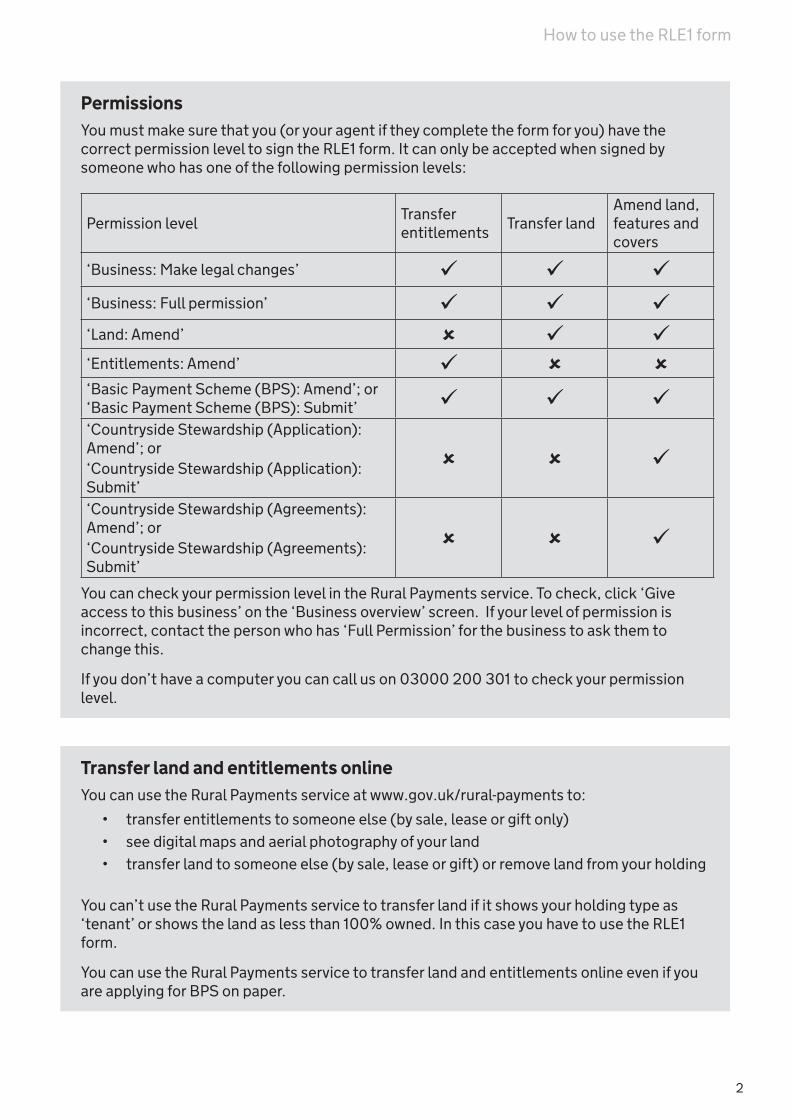
PermissionsYou must make sure that you (or your agent if they complete the form for you) have the correct permission level to sign the RLE1 form. It can only be accepted when signed by someone who has one of the following permission levels:
Permission levelTransfer entitlements
Transfer landAmend land, features and covers
‘Business: Make legal changes’ ‘Business: Full permission’ ‘Land: Amend’ ‘Entitlements: Amend’ ‘Basic Payment Scheme (BPS): Amend’; or ‘Basic Payment Scheme (BPS): Submit’ ‘Countryside Stewardship (Application): Amend’; or ‘Countryside Stewardship (Application): Submit’
‘Countryside Stewardship (Agreements): Amend’; or‘Countryside Stewardship (Agreements): Submit’
You can check your permission level in the Rural Payments service. To check, click ‘Give access to this business’ on the ‘Business overview’ screen. If your level of permission is incorrect, contact the person who has ‘Full Permission’ for the business to ask them to change this.
If you don’t have a computer you can call us on 03000 200 301 to check your permission level.
Transfer land and entitlements onlineYou can use the Rural Payments service at www.gov.uk/rural-payments to:
• transfer entitlements to someone else (by sale, lease or gift only)
• see digital maps and aerial photography of your land
• transfer land to someone else (by sale, lease or gift) or remove land from your holding
You can’t use the Rural Payments service to transfer land if it shows your holding type as ‘tenant’ or shows the land as less than 100% owned. In this case you have to use the RLE1 form.
You can use the Rural Payments service to transfer land and entitlements online even if you are applying for BPS on paper.
How to use the RLE1 form

3
What to use the RLE1 form for
RLE1 form
Online Rural Payments
ServiceLand Map a new land parcel for the first time
Make permanent changes including:
• changing the size and shape of a land parcel
• split and/or merge parcels
• register a permanent non-agricultural area or feature
Remove or transfer a land parcel from your holding Remove or transfer a land parcel from your holding if Rural Payments service shows your holding type as ‘tenant’
Remove or transfer a land parcel from your holding if Rural Payments service shows:
• your holding type as ‘owner’, and
• less than 100% of the land parcel as owned
Tell us about a changes to the land cover (arable, permanent grassland, permanent crops and non-agricultural)
Map hedges and trees in a line that are not shown in the Rural Payments service
Tell us that you do not agree with changes made as part of a digital mapping update including:
• changes to a permanent land parcel boundary
• changes to the land cover – if there is only one land cover for a land parcel you can call us
• removal of permanent non-agricultural areas or features
BPS Entitlements
Transfer by sale or as a gift Transfer entitlements by lease Transfer by sub-lease Transfer through inheritance Surrender entitlements to RPA
How to use the RLE1 form

4
You must use an RLE1 form to transfer entitlements if there is an ongoing dispute about your entitlement information in the Rural Payments service.
When you use the Rural Payments service to transfer land parcels and/or entitlements you must not send in an RLE1 form for the same transfer.
If you have sent an RLE1 form to transfer land but now want to use the Rural Payments service to make the same change, you need to call us on 03000 200 301 to check the latest advice for the specific change you want to make.
If you have sent an RLE1 form to transfer entitlements to be used in 2018 but the transfer hasn’t yet been completed, you can still make the transfer online using the Rural Payments service.
Once you’ve transferred your entitlements online, you need to send us an email (from an email address that is registered in the Rural Payments service against a person with at least ‘BPS: Amend’ or ‘Entitlements: Amend’ permission), or call us asking to withdraw your RLE1 form. The email subject heading should include ‘BPS 2018 – Withdraw entitlements transfer RLE1’.
You’ll need to tell us the following information from your RLE1 form:
• Single Business Identifier (SBI) of the business transferring the entitlements
• SBI of the business receiving the entitlements
• type of transfer: state that this is an entitlement transfer RLE1 form
• the method of transfer, for example, sale, gift or lease
• the number of entitlements and payment region they’re in.
Business changesYou may also need to fill in an RLE1 form if your business is involved in either a merger, split (scission) or other business change which results in a new business being formed.
You need separate RLE1 forms if you want to transfer both land and entitlementsYou need to use at least 2 separate RLE1 forms to transfer land and transfer entitlements. This is because we process land and entitlement requests separately, so they need to be on separate forms. We also need separate forms if you have different types of entitlement transfer. You can do both or either in the Rural Payments service.
How to use the RLE1 form

5
When not to use an RLE1 formDo not use an RLE1 form to:
• tell us about changes to your eligible land uses in a land parcel – you do this in Part C on your BPS application (the ‘Land use’ screen in the Rural Payments service). Land use is not the same as land cover. Examples of land use are: winter wheat, spring barley
• tell us about your ecological focus areas (EFAs) – you do this in Part D of your BPS application (the ‘Land use’ screen in the Rural Payments service). You don’t need to draw your EFAs on your maps – this does not apply to hedges and trees in a line. If you want to include hedges and trees in a line on your BPS application, Countryside Stewardship agreement and/or Environmental Stewardship agreement but you can’t see them in the Rural Payments service, you need to use an RLE1 form to add them to your digital maps
• show us where your crops are for the crop diversification rules – you just need to enter each land use for a parcel in Part C of your BPS application (the ‘Land use’ screen in the Rural Payments service)
• map any features or options you have in a Rural Development Programme agreement - unless they change the land cover of your land parcel.
• tell us about features that will only be temporarily ineligible – you can do this on your BPS application
Read the scheme rulesThis guidance tells you how to use the RLE1 form. It does not give any scheme rules. Read the rules for the relevant scheme before you use this form.
We reject RLE1 forms and return them if Parts A and F are not completed correctly, or Part F has been amended in any way. If we require further information about Parts B, C and D we will contact you and request this information before processing the RLE1 form.
It is your responsibility to make sure that you:
• only claim on your land that is eligible for the scheme you are claiming
• check your maps, either online or on paper
• tell us about any changes.
You can view your land details online using the Rural Payments service.
We continuously use all available data sources, including aerial photography and Ordnance Survey map updates, to keep our land information up-to-date, and to check any claims you make.
It’s important that you check your digital maps online because we’ve reviewed and updated our mapping information, where necessary, since applications were made for BPS 2017. If we’ve updated your land parcels, you will have received notifications in the ‘Messages’ tab in the Rural Payments service identifying which land parcels have been updated.
If you have requested a change to your digital maps, either by calling us or by sending an RLE1 form and sketch map to us, we will write to you. We’ll either confirm that we’ve made the changes you requested or we’ll explain why they can’t be made.
How to use the RLE1 form

6
Transfer Basic Payment Scheme (BPS) entitlementsTo transfer BPS entitlements by paper, fill in Parts A, B, C, E and F of the RLE1 form.
When to transfer entitlements You can use an RLE1 form to transfer or give up (surrender) BPS entitlements at any time of year but there are scheme deadlines for receipt of some transfers.
Only the person who holds the entitlements at the deadline set in the BPS scheme rules can use them to claim BPS in any given scheme year. Read the latest BPS scheme rules to check when this is: www.gov.uk/rpa/bps.
So if the person you’re transferring entitlements to wants to use them to claim BPS, we must receive the RLE1 form by this time.
If we receive the RLE1 form after this, or the effective date is after this, the entitlement transfer will take effect in the next scheme year. We cannot backdate entitlements transfers to be effective for a previous scheme year.
The date that the transfer becomes effective (‘effective date of transfer’) can be up to a year after the date you send the RLE1 form.
What happens nextThe transfer cannot be approved until the BPS claim for the previous scheme year for the person transferring the entitlements has been paid. We send a notification in the Rural Payments service to both the person transferring the entitlements and the business receiving the entitlements that the transfer is complete. We do this after the transfer has been approved.
If the transfer isn’t successfulIf the transfer isn’t successful, we send an email or letter to both the person transferring the entitlements and the person receiving them. They only tell the person transferring the entitlements the reason why the transfer was not successful.
Who can transfer BPS entitlementsTo transfer, surrender or receive entitlements, you must:
• make sure that you (or your agent if they complete the form for you) have the correct permission level to sign the RLE1 form (read ‘Permission levels’ on page 2)
• be registered in the Rural Payments service (your agent must be registered if they complete the form for you)
• have a main Single Business Identifier (SBI)
A main SBI is a unique nine digit number given to a farmer or business that is involved in an agricultural activity. It is not the same as a trader SBI.
Transferring Basic Payment Scheme (BPS) entitlements

7
You can’t transfer more entitlements than you haveThe number of entitlements you’re transferring or surrendering can’t be greater than the number you hold. If it is, we can only transfer the maximum number of entitlements you hold. If you have already transferred all the entitlements you hold to another farmer or business, we will reject the transfer. Check the Rural Payments service for the latest information about your entitlements.
Invalid transfersYou may want to take independent professional advice before making a decision to transfer entitlements.
If we find that a completed transfer becomes invalid later, we may reclaim the transferred entitlements. This could happen if, for example, a previous owner of the entitlements didn’t use them properly and they should have already expired.
If a farmer receives entitlements that they shouldn’t have had, the transfer is invalid and they will lose those entitlements. In these cases, the transferred entitlements (whether they were leased or sold) will not be returned to their original owner.
If the recipient has already transferred them again (to a third business) that business may lose some or all of the entitlements that came from the invalid transfer.
In all the above cases, the farmer receiving the entitlements will also have to pay back any BPS payments they should not have received while they held the entitlements.
Types of transfers
You need separate RLE1 forms for different types of transferIf you use an RLE1 form to transfer entitlements, you must fill in a separate form for every different type of transfer that you do – for example, one form for entitlements transferred by lease and another for entitlements transferred by sale.
Transfer by sale or giftYou can do this online using the Rural Payments service, although we also accept RLE1 forms for this type of transfer.
Transfer by leaseYou can do this online using the Rural Payments service, although we also accept RLE1 forms for this type of transfer.
You must include the lease end date on the RLE1 form.
At the end of a lease, the leased entitlements automatically return to the lessor.
We no longer contact both parties after the lease end date has passed, to tell them that the entitlements have transferred back.
If the lessor wants to end the lease early or extend the term, they must tell us by letter or email before the change takes effect. Only the lessor can extend the lease, although both lessor and lessee may give notice by letter or email to end the lease early.
Transferring Basic Payment Scheme (BPS) entitlements

8
Subleasing entitlementsYou must use the RLE1 form to sublease entitlements – you can’t do this in the Rural Payments service.
You can sublease entitlements but the sublease cannot last longer than the lease of the entitlements.
Transfer through inheritance You must use an RLE1 form for this – you can’t do it in the Rural Payments service.
When a sole trader dies, the executor or administrator to the estate of the deceased should fill in a separate RLE1 form for each beneficiary.
If there is more than one executor or administrator, they must all sign the RLE1 form(s), unless they agree to authorise only one of them to sign for the others. We need proof of this agreement in writing.
An inheritance transfer can be back dated to the settlement date of the estate if the transferor or their estate hasn’t already been paid for the scheme year of the settlement.
Giving up your entitlements (surrendering your entitlements)You must use the RLE1 form for this – you can’t do it in the Rural Payments service.
You can also give your entitlements back to us if you don’t want to use them or transfer them to anyone else.
Transfer as part of a business merger or scissionYou can do this online using the Rural Payments service, although we also accept RLE1 forms for this type of transfer.
If your business structure changes, you may need to transfer entitlements. For example if:
• 2 or more farming businesses are merging to form a single business
• a single business is splitting into 2 or more businesses
• other changes are taking place which result in a new business being formed
Read the latest BPS rules for more information about business structures and also read: www.gov.uk/guidance/change-the-details-youve-registered-with-the-rpa
We may ask you for more information about all the changes to the structure of a business and any associated businesses. Until this information is assessed, we won’t know who the entitlements can legally be transferred to and any RLE1 forms will be put on hold.
We may also ask you to fill in a ‘separate business questionnaire’ (also known as an ‘IACS 26’) to confirm the changes that are taking place. See: www.gov.uk/guidance/change-the-details-youve- registered-with-the-rpa
We may treat the business that you or others are involved in as one business, even though you may run these businesses separately for commercial reasons.
MergersIf businesses are merged, each original business must fill in an RLE1 form. These must be signed by someone who has the correct level of permission on behalf of all members of that business.
Transferring Basic Payment Scheme (BPS) entitlements

9
ScissionsIf a business is split (a scission), a separate RLE1 form must be filled in for each new SBI you want to transfer entitlements and/or land to. RLE1 forms must show how the entitlements and/or land are being divided and transferred to each business. Entitlement transfers must be on a separate RLE1 form to land transfers. All partners must sign the RLE1 forms.
If other business changes are to take place, for example, a partnership is being dissolved and a new independent business is being formed (not a continuation of the old business), the RLE1 form should be signed by all partners in the old business.
If a family member is not already a partner in the business and will be farming as a new business or is already farming in their own right as a separate business, you need to transfer your entitlements to them by filling in an RLE1 form. If you are a new business, you must register for rural payments online.
Transferring Basic Payment Scheme (BPS) entitlements

10
Registering land and making mapping changesYou can see digital maps of all the land parcels registered to your holding using the Rural Payments service.
We use digital maps to record physical land parcel boundaries and features for land which will be claimed on for the following rural payments schemes:
• Basic Payment Scheme
• Countryside Stewardship
• Environmental Stewardship
• Habitat Scheme
• English Woodland Grant Scheme
• Farm Woodland Premium Scheme
• Woodland Carbon Fund (only if another scheme such as BPS is also claimed)
• HS2 Woodland Fund (only if another scheme such as BPS is also claimed)
• National Forest Changing Landscape Scheme
To claim these rural payments, you will need to check that your digital maps correctly register:
• all the agricultural land parcels on your holding
• all their permanent boundaries
• all permanent non-agricultural areas or features within them
• all the non-agricultural land parcels on your holding which you manage under a Rural Development Programme agreement, the Woodland Carbon Fund, HS2 Woodland Fund or under the National Forest Changing Landscape Scheme
You do not have to register your land to claim Woodland Carbon Fund or HS2 Woodland Fund if they are the only rural payments you claim.
Where to find your mapsGo to: www.ruralpayments.service.gov.uk. From the ‘Business overview’ screen, click ‘Land’ then ‘View land’.
How to print your mapsYou can download and print your digital maps. Go to the Rural Payments service. From the ‘View land’ screen select the land parcel you need. The ‘Parcel details’ screen shows a digital map and details of the land parcel. Below the map, click on ‘Download a print-friendly version of this page (PDF)’ and follow the instructions.
You should use these paper maps whenever you need to send us a sketch map with your RLE1 form. If you can’t do that, you can use maps that we’ve sent you in the past, or use the best maps available to you. A sketch map should be a printed map which you have clearly marked with the changes you want to make.
Registering land and making mapping changes

11
When to use an RLE1 form to update your mapsCheck your digital maps carefully to make sure they are correct. If you need to make changes you can do this online or using the RLE1 form.
If the digital maps don’t show all of your land correctly, first read the latest ‘How to claim BPS online’ guidance, which explains what changes you can make online and if and when you need to use an RLE1 form. Read more information about how to check and update your digital maps in this guide on Page 20
You must fill in an RLE1 form to:
• register a new land parcel for the first time
• change the size of a land parcel (because the permanent boundary has changed)
• split or merge land parcels
• transfer part of a land parcel to another holding
• tell us about a permanent non-agricultural area or feature in a land parcel which is not on your maps or you need to correct it on your maps because the size has changed
• remove or transfer land if your holding type in the Rural Payments service is ‘tenant’ or if it shows less than 100% of the land parcel as owned
• tell us about a change to the land cover (arable, permanent grassland, permanent crops and non-agricultural) – where there is only one land cover for a land parcel you can call us
• tell us that you do not agree with changes we have made including:
• changes to a permanent land parcel boundary
• changes to the land cover where there is more than one land cover for a land parcel – where there is only one land cover for a land parcel you can call us
• removal of permanent non-agricultural area or features
• map hedges and trees in a line that you want to include in your rural payments scheme applications but aren’t showing on your digital maps in the Rural Payments service
If another person has transferred land to you and you can’t see it in the Rural Payments service you can call us.
You can use the Rural Payments service to transfer land parcels to someone else by sale, gift or lease unless your holding type is shown as ‘tenant’ or it shows less than 100% of the land parcel as owned.
When you use the Rural Payments service to transfer land parcels you must not send in an RLE1 form for the same transfer.
If there is more than one person with an interest in the land parcel (for example, a landlord and tenant sharing use of a land parcel) please make sure that you agree any changes with the other person using the land, as it may affect your claims.
Pending changesWhen we get your RLE1 form, your change will show as pending on your digital maps. You will see an exclamation mark icon. If you can’t see this icon then your RLE1 form has not yet been marked as pending in the Rural Payments service. You don’t need to send a new RLE1 form if you have already sent one.
Registering land and making mapping changes
12
Sending sketch maps to usIf you make any:
• permanent changes to the shape of your land parcels
• permanent changes to the size of your land parcels
• changes to the land cover of your land parcels (only if there is more than one land cover in the land parcel)
you must send sketch maps to us with your RLE1 form. You should download and print maps of your land parcels from the Rural Payments service. If you can’t do that, you can use maps that we’ve sent you in the past, or use the best maps available to you. You must make sure that your SBI number is clearly marked on any sketch maps you send to us.
Marking changes on sketch mapsWhen you send your RLE1 form to us to make mapping changes to your registered land, it is important you send accurate sketch maps. We use your sketch maps alongside aerial photography and Ordnance Survey map updates so that we can make correct updates.
You must:
• use a fine-tipped colour pen to draw, as accurately as possible, on your sketch map(s) the changes you want to make
• if there is a change to the land cover, and there is more than one land cover in the land parcel, you must make sure that the sketch map is clearly marked with the new land covers (arable, permanent grassland, permanent crops and/or non-agricultural) and the different land cover areas in the land parcel. If the land cover is non-agricultural, where possible write the land use code from Annex 1 (this will help record it correctly)
• if the boundary or part of it, is marked by boundary stones or marker posts you must show this clearly on your sketch map. Use a different colour pen to draw the boundary that is marked by boundary stones or marker posts. Label this boundary clearly on your sketch map to show it is marked by boundary stones or marker posts. This will reduce the risk of parcels being merged in error in the future
• provide all measurements needed in metric. You can use the online measuring tool in the Rural Payments service or other online mapping tools such as Google Earth or Magic for accurate, metric measurements
• use other mapped features as reference points, for example, fence lines and buildings
• be specific when noting the land use of any new features in a land parcel
• clearly mark hedges and trees in a line that you want added to your registered land. Include the length of the hedge or the line of trees
• cross through the boundary you want removed to merge parcels. You need to clearly identify which parcels you want merged and include their parcel IDs
• make sure that new and existing parcel numbers are clearly identified on the sketch maps
• clearly write your SBI number on each map you send to us
• provide additional notes, where possible, on the sketch map. This includes those that you have included in your covering letter
• use the most up-to-date maps available
Registering land and making mapping changes

13
You must not:
• guess or estimate the feature or boundary areas and lengths
• request parcel boundaries that are not valid permanent boundaries. Pages 14 and 15 explain what is a permanent boundary and what isn’t
• request woodland (a non-agricultural land cover) as arable land, permanent grassland or permanent crops (agricultural land covers) on your sketch map. Pages 16 and 17 explain about trees and woodland. If you have non-agricultural land that is either of the following:
• under a suitable agri-environment agreement, woodland agreement or the National Forest Changing Landscape Scheme;
• under Woodland Carbon Fund or HS2 Woodland Fund, and you claim that land as RD01 on your BPS application;
you should note it on your sketch map with the current land cover/use of the parcel, for example, woodland or scrub. This is in line with Forestry Commission guidance ON42
• send us multiple maps that contradict each other. You must add additional notes to your sketch map and covering letter if you want a new sketch map to replace one you sent us previously.
What land to registerYou must register all agricultural areas on your holding which are 0.0100 hectares or larger.
Agricultural land parcels Agricultural land is:
• arable land (including temporary grassland and fallow land)
• permanent grassland
• permanent crops
All other land is ‘non-agricultural’. For a full list of non-agricultural land, go to www.gov.uk/guidance/bps-2018
Non-agricultural land parcelsYou must also register any non-agricultural land parcels that you’re managing (or intend to manage) under a Rural Development Programme agreement or the National Forest Changing Landscapes Scheme.
A land parcel of woodland/forestry must be registered if it is in, or will be in:
• a Rural Development Programme scheme or the National Forest Changing Landscapes Scheme
• Woodland Carbon Fund or HS2 Woodland Fund, and you are claiming for payment under BPS for the same land parcel(s).
What land to register

14
Permanent land parcel boundariesYou must use an RLE1 form to tell us about any changes to the permanent boundaries of a land parcel which you expect to last for 3 years or more.
Permanent boundaries are:
• fixed fences (but not temporary electric fences)
• walls (including Cornish hedges)
• hedges
• lines of trees
• Devon banks (a bank forming a parcel boundary for the purpose of, for example, containing livestock)
• watercourses, for example, ditches, rivers and streams
• changes in vegetation that are clearly visible on the ground, for example, woodland next to grass, but not crop splits
• roads or man-made surfaced tracks
• boundary stones, marker posts (see below) or the extent of common land, registered under the Common Registration Act 1965 or Part 1 of the Commons Act 2006
You can find definitions of these at www.gov.uk/guidance/bps-2018
English Area/payment regions in England will be counted as a permanent land parcel boundary.
Using marker posts as a permanent boundaryYou can choose to use marker posts (for example, fence posts with a minimum diameter of 75mm) as a permanent boundary. If you do, we recommend they have a white or coloured top so that they can easily be seen. This is important because RPA inspectors will look for them to be clearly visible and not moveable.
If you use marker posts, there should be at least three posts to identify a straight boundary, marking both ends (as near as is practical) and the mid-point. If the boundary does not follow a straight line, you should use a post to mark each turning point in the boundary line.
Marker posts should be maintained and visible (for example, not obscured by vegetation). It is important that the position of the posts is accurately measured so that the details on the map match the actual location of the boundary. Ordnance Survey will not identify the posts or the boundary on their maps. RPA inspectors will measure the boundary in the normal way if they inspect the holding.
Boundaries across more than one part of the UKA land parcel can only be in one part of the UK. This means that a national boundary is a permanent boundary.
We split land parcels accordingly and give separate reference numbers to the resulting land parcels.
Permanent land parcel boundaries

15
What is NOT a permanent boundary?The features listed below are not classed as permanent boundaries:
• ownership boundaries
• temporary boundaries such as electric fences (this only refers to temporary electric fencing and not permanent fencing that is electrified), plough lines or buffer strips
• underground drains which are not visible on the ground
• administrative boundaries such as parish boundaries which don’t follow a physical feature on the ground
• map grid lines
• natural-surfaced (unsurfaced) tracks and paths, in particular muddy tracks, that can either be ploughed up or can move slightly from year to year
Cropping splits and ownership boundariesCropping splits and ownership boundaries are not classified as permanent boundaries. If you want to register a field boundary based on a cropping split or ownership boundary, then you must use marker stones or posts (read page 14) to create a permanent boundary which can be mapped.
Shared land parcelsIf a land parcel is occupied by more than one person, they should both register the whole land parcel according to its permanent boundary – not according to the area each person occupies.
If you want to change the permanent boundary of a shared land parcel, you should speak to the other occupier(s) to make sure that you all agree to the change, as it may affect your claims for different schemes.
How to register changes to permanent boundaries You will need to send sketch maps to us with your RLE1 form (read ‘Sending sketch maps to us’ on page 12 and ‘Marking changes on sketch maps’ on pages 12 and 13). Using a fine-tipped colour pen, draw on your sketch map(s) as accurately as possible to show what changes you want to make.
You must make sure that your SBI number is clearly marked on any maps you send to us.
If you’re not using RPA maps, clearly mark the boundaries of the land parcels on the maps. Remember to write on the map:
• the current Ordnance Survey sheet references and grid references of each of the parcels you’re making changes to
• an estimate of what the new references will be - read page 60 to find out how.
Tell us the measurements (in metres) of all the new permanent boundaries.
If adding a new permanent boundary creates a separate land parcel, you need to tell us whether you want to register the new parcel as part of your holding. If you don’t, the separate parcel will be removed from your registered holding.
If you have any other maps such as site plans or Compulsory Purchase Orders you should send a copy of these to us. Please supply any information that you have which clearly shows the changes you want to make, and believe could be of use to us. We won’t be able to return any documents that you send, so please make sure that you keep the original copy for your records.
For more information about how to make boundary changes read pages 31 and 32.
Permanent land parcel boundaries

16
Non-agricultural areas and featuresMany agricultural land parcels contain areas and features which are permanently non-agricultural. To claim rural payments, these will need to show correctly on your digital map(s) in the Rural Payments Service.
RPA has already used Ordnance Survey information and information supplied by farmers to map as many of these features as possible – you can see them on your digital maps online. You can see your digital maps on the ‘View land’ screens in the Rural Payments service.
Telling us about permanent non-agricultural areas or features that aren’t on your digital mapsIf there are features which aren’t on your digital maps, you need to tell us about them using an RLE1 form and a sketch map.
You must make sure that areas or features which are 0.0100 hectares or more are marked on the sketch maps that you send.
You normally only need to tell us about the areas or features which lie within the permanent boundary of an agricultural land parcel, or form part of the permanent boundary itself. However, you also need to tell us about areas or features that are outside land parcel boundaries if they are included, or will be included, in your Rural Development Scheme agreement.
In Annex 1, there is a full list of non-agricultural areas and features which you must make sure are registered on your digital maps.
‘Scattered features’Some non-agricultural areas or features may be small and scattered across a land parcel. In these cases, the farmer must add up the sizes of the individual features. If they add up to 0.0100 hectares or more, they must be registered using the appropriate ‘scattered feature’ code and show on your maps.
Trees and woodlandTrees are considered part of the agricultural area of a parcel if they are:
a. individual trees scattered within an agricultural parcel
b. lines of trees (of a maximum of two trees wide) on an agricultural parcel
c. groups of trees on an agricultural parcel that are not adjacent to a boundary and
i. the area underneath the canopy is used for agricultural activity (this condition is met where it is suitable for cultivation or grazing of livestock)
ii. more than 50% of the area underneath the tree canopy is covered by grasses, other herbaceous forage or arable land
d. groups of trees on an agricultural parcel that are adjacent to a boundary, and
i. the area underneath the canopy is used for agricultural activity (this condition is met where it is suitable for cultivation or grazing of livestock)
ii. if unsuitable for cultivation, the entire area under the canopy is accessible to farm animals for grazing, and
iii. more than 50% of the area underneath the tree canopy is covered by grasses, other herbaceous forage or arable land.
Non-agricultural areas and features

17
All other groups of trees are woodland which is a non-agricultural area.
Areas of woodland that prevent agricultural activity should be registered and mapped as woodland.
Claiming rural paymentsTo find out if a non-agricultural area or feature is eligible for a particular scheme, read the relevant scheme guidance.
Non-agricultural areas and features

18
Transferring or removing landTransferring or removing a land parcel you are no longer in control ofYou may have land that shouldn’t appear under your SBI because you no longer have control of it. For BPS it’s no longer at your disposal and for other Rural Payment schemes it’s not under your management control. For example, you don’t farm it any longer or you tried to delete it from your BPS application last year and it’s still appearing. You can remove it from your holding (record) in the Rural Payments service. If you can’t use the online service you must fill in an RLE1 form to remove the land parcel from your record. This is the same process given below in ‘Removing land where holding type on Rural Payments is shown as tenant or if it is showing that less than 100% of the land parcel is owned’.
If you remove land from your holding record it will completely remove the land parcel from your record. This means you won’t be able to claim for payment on that land parcel for either BPS or agri-environment and woodland schemes. So if you still control (for BPS it’s at your disposal and for other Rural Payment schemes it is under your management control) the land parcel for one of these schemes, don’t remove the land from your record.
If you remove a land parcel under an existing agri-environment or woodland scheme agreement, this may affect your agreement or payment. Read page 10 for a list of these schemes.
You may have land that has been linked to your SBI by mistake. You can remove this land from your holding (record) in the same way as transferring land.
In these cases you need to:
• at Part B2 - fill in ‘Parcel never linked to business’ instead of a business name
• at Part B3b – fill in the ‘Effective date of transfer’ as 01/01/2010
Transferring land where holding type in the Rural Payments service is shown as tenant or if it is showing that less than 100% of the land parcel is ownedIf your ‘holding type’ is ‘tenant’ in the ‘Transfer land’ screen of the Rural Payments service or it is showing that less than 100% of the land parcel is owned, you have to use an RLE1 form to transfer the land parcel to another business. You cannot do this in the Rural Payments service.
Removing land where holding type in the Rural Payments service is shown as tenant or if it is showing that less than 100% of the land parcel is ownedIf your ‘holding type’ is ‘tenant’ in the ‘Transfer land’ screen in the Rural Payments service or it is showing that less than 100% of the land parcel is owned, you have to use an RLE1 form to remove the land parcel.
In these cases you need to:
• at Part B1 – use the option ‘Sale/gift of land’
• at Part B2 - transfer the land parcel to the SBI we have set up to remove land parcels from your claim - SBI 200116651. The business name for this SBI is ‘Land removed from your holding’
• at Part B3b – fill in the ‘Effective date of transfer’ as 01/01/2018
• at Part D - fill in the land parcel details
Transferring or removing land
19
Land cover changesWhat is land cover?Land cover is not the same as land use. We classify land by looking firstly at the physical nature of the land, these categories are referred to as land covers. We then look at the activities the land is used for, these sub-categories are referred to as land uses.
Land cover categories are:
• arable land
• permanent grassland
• permanent crops
• non-agricultural area
Examples of land use are:
• winter wheat
• spring barley
• temporary grassland
• permanent grassland
• short rotation coppice
• woodland
• farm building
• structure
How to tell us about changes to your land cover There are 2 ways you can tell us about changes to your land cover.
• If there is only one land cover for a land parcel, you can call us.
• If there is more than one land cover for a land parcel, you must fill in an RLE1 form and send it to us with a sketch map clearly marked with the land cover(s) and areas. You must also write ‘Mapping change query’ on your RLE1 form and sketch map.
If you want to tell us about several land parcels, each with only one land cover, it is better to fill in an RLE1 form than to call us.
Land cover changes

20
How to check and update your digital maps It is your responsibility to check your digital maps in the Rural Payments service throughout the year and tell us:
• about any changes to your land
• if you do not agree with a change that we’ve made
How to check your maps/land parcelsYou can see digital maps of all the land parcels registered to your holding using the Rural Payments service.
1 Go to: www.ruralpayments.service.gov.uk.
2 From the ‘Business overview’ screen, click ‘Land’ then ‘View land’.
3 To view individual land parcel details select the land parcel you need. The ‘Parcel details’ screen shows you a digital map and details of the land parcel. There is also a ‘Photo’ option as well as the ‘Map’ option.
If you believe the map or any of the details are incorrect check the map against the photo to see if they match.
If the map and photo do not match, you can call us.
If the map and photo match then the mapping process is correct.
How to check and update your digital maps

21
If you still believe the map or the details are incorrect because
• you have made changes to the land
• you disagree with a change we have made you need to request a change to your digital maps
read the information below.
If you are not sure why the change has been made, you can call us.
Requests for changes to your digital maps and land parcel details could affect payments you have already received as well as future payments. Only tell us about changes if you are sure they need to be made.
Land coverIf you want to change the land cover read ‘Land cover changes’ Page 19 and ‘Part D: Change land cover’ Page 41 and 42. If your land cover change request is because you do not agree with a change we made, you need to write ‘Mapping change query’ on your RLE1 form and sketch map.
Changes other than land coverHow to tell us about changes you have made
Read the instructions in this guidance and then fill in an RLE1 form and send it to us with relevant sketch maps. You can use the Rural Payments service to print maps of your land parcels. Information on how to mark changes on maps is given on page 12 of this guide.
How to tell us you do not agree with a change we have made
If you:
• have evidence (read the ‘Evidence’ section below) to support why you do not agree with the changes and
• believe they will have a significant effect on your rural payments schemes’ payments or agreements.
read the instructions in this guidance and then fill in the RLE1 form and send it to us with relevant sketch maps. You can use the Rural Payments service to print maps of your land parcels. Information on how to mark changes on sketch maps is given on page 12 of this guide.
You must also:
• write on the RLE1 form and the sketch map ‘Mapping change query’ and mark the changes you would like to make – read ‘Do I need to send any evidence with my RLE1 form and sketch map(s)’ below for anything else that must be written on the sketch map(s)
• mark on the RLE1 form and sketch map what scheme this update relates to (include which scheme year), such as the Basic Payment Scheme, a Countryside Stewardship application, an Environmental Stewardship Agreement
• add the land parcel you are querying on the RLE1 form and the date when the change was made on the ground. If you believe there has never been a change to the land parcel please use 1 January 2015 as the effective date.

22
Send your BPS application and tell us about updates to your maps later, if all the following apply:
• you disagree with a land parcel split or merge that we’ve made
• you are the only person claiming on the parcel(s)
• there is no overall change to the eligible area you are claiming
You can fill in the RLE1 form and send it to us with relevant sketch maps later in the year.
Do I need to send any evidence with my RLE1 form and sketch map(s)?
You do not need to send any specific evidence with your RLE1 form and sketch maps. However, you need to be absolutely sure that the changes you request are necessary and correct. We use the latest developments in aerial photography so we may need:
• further evidence from you
• to inspect the land parcel
before we accept the request for change.
If you believe that your request for changes are necessary then you need to send us your RLE1 form with your sketch maps.
To change a boundary fill in the RLE1 form and send it with your sketch map(s) clearly marked to show the boundary and write on what type of permanent boundary it is.
To add a non-agricultural area or feature – fill in the RLE1 form and send it with your sketch map(s) clearly marked to show the non-agricultural area or feature.
To remove a non-agricultural area or feature – fill in the RLE1 form and send it with your sketch map(s). The sketch map(s) should clearly show the non-agricultural area or feature with a cross marked through it. Write clearly on the map that you want to remove the area or feature.
There isn’t a deadline for sending your RLE1 form and sketch map to tell us that you do not agree with a mapping change. We review every ‘Mapping change query’ RLE1 form that is received, however our focus is on making payments. This means depending on when you send your RLE1 form, it may take time to review your request.
Whether you have requested a change to your digital maps by calling us or by sending an RLE1 form and sketch map to us, we will write to you. We’ll either confirm that we’ve made the changes you requested or we’ll explain why they can’t be made.

23
How to fill in your RLE1 formA step-by-step guide explaining how to fill in your RLE1 form and what to draw on your map(s).
You only need to fill in the parts of the form which are relevant to you but you must return the whole RLE1 form to RPA.
Please remember:
• don’t use correction fluid
• you must enter an effective date in Part D for all requests
• you must not change any of the wording in Part F
• it is your responsibility to make sure the information you give on this form is accurate and correct.
Part A: General details Fill in your SBI and Name of beneficiary (or business name). The main County Parish Holding (CPH) number is no longer mandatory. You also need to say whether you are claiming under a Rural Development Programme for England (RDPE) scheme.
County Parish Holding (CPH) numberIt is no longer mandatory to fill in CPH numbers on the RLE1 form
Please remember that there are Defra rules on the allocation of CPHs and British Cattle Movement Service (BCMS) links to land parcels for animal movements and disease control purposes.
If you don’t have an appropriate CPH to use, call 03000 200 301 to get a new one.
How to fill in your RLE1 form

24
Part B: Transfer or remove detailsFill in Part B if you want to:
• transfer BPS entitlements or land
• remove land
You must fill in a separate RLE1 form for each type of transfer or removal – for example, one form for transfer by lease, one form for transfer by sale and another form for removing a parcel no longer part of the occupied land. You must also use separate RLE1 forms for land and entitlements transfers.
You don’t need to fill in Parts B and C if you only want to register new fields, make changes to permanent non-agricultural areas or features or make permanent boundary changes to your holding.
B1 – How are you disposing of your entitlements or land?Put an ‘X’ in one box to tell us which type of transfer you want to make. You must only put an ‘X’ in one box. Inheritance can apply to land or entitlements.
To remove land when your holding type is ‘tenant’ in the Rural Payments service or it shows less than 100% of the land parcel as owned you must put an ‘X’ in the ‘Sale/gift of land’ box.
B2– Details of the business you are transferring entitlements or land toFill in the SBI and name of the beneficiary or business you are transferring the entitlements or land to. You need to give us these details or your transfer may be rejected.
To remove land when your holding type is ‘tenant’ in the Rural Payments service or it shows less than 100% of the land parcel as owned you must use the SBI 200116651. The business name for this SBI is ‘Land removed from your holding’.
How to fill in your RLE1 form

25
If the business receiving the entitlements or land doesn’t have an SBI, they should register on www.gov.uk/claim-rural-payments to get one. You must get their SBI from them before you send your RLE1 form to us (except for inheritance, mergers or scissions where we are still assessing a new business).
The SBI is not needed in B2 if:
• you are giving up entitlements
• you are only transferring land out of agricultural production (for example, land that has been sold for residential use).
B3a – CPH number of the farmer receiving the landIt is no longer mandatory to fill in CPH numbers on the RLE1 form
B3b – Effective date of transferFill in the date you want the transfer to take place. We must have this information for all transfer types.
The effective date can only be backdated when:
• the transfer is for inheritance or
• it is to remove land if your holding type is ‘tenant’ in the Rural Payments service, or
• it is to remove land if the Rural Payments service shows less than 100% of a land parcel as owned,
If you are removing land for any of these reasons, you must fill in the ‘effective date of transfer’ as 01/01/2018.
B3c – Lease start dateOnly fill in a date if the transfer is a lease or sub-lease. Give the date your lease or sub-lease agreement starts.
B4 – Lease end date Only fill in this date if the transfer is a lease or sub-lease. Give the date when the lease or sub-lease agreement ends. You must give a lease end date.
B5/B6 – Merger or ScissionOnly fill in these questions if your transfer is as a result of a merger or scission. If not, ignore these questions.
Put an ‘X’ in either the Merger or Scission box if your transfer is as a result of a business change. If you have filled in B5, go to B6.
You should also put an ‘X’ in one box to confirm whether you have updated your registered business details in the Rural Payments service or filled in and sent us a ‘separate business questionnaire’. You must do one of these things before we can make the transfer. Until then, we will put your RLE1 form on hold.
How to fill in your RLE1 form

26
Part C: Entitlements to be transferred/surrenderedFill in Part C if you want to transfer or surrender entitlements (give them up).
You can check the details of your entitlements in the Rural Payments service.
You can only transfer entitlements that you hold on the day you send the RLE1 form to us.
C1 – Number of entitlements heldFor each region you want to transfer entitlements from, enter the number of entitlements you hold in that entitlement region, to 2 decimal places.
This is the number of entitlements that you hold, not the number that you are transferring.
C2 – Number of entitlements to transfer/or surrenderFill in the number of entitlements to transfer/surrender in each entitlement region.
Put an X in ‘All’ if you want to transfer/surrender all your entitlements in that region. Leave both boxes blank if you don’t want to transfer/surrender any entitlements in that region.
How to fill in your RLE1 form

27
Part D: Register a land parcel to your holding
What to draw on your sketch mapTo register a land parcel to your holding (whether it has been mapped before or not), mark the boundary using a fine-tipped colour pen and mark the correct Ordnance Survey sheet and National Grid field number if you know it.
If the boundary or part of it, is marked by boundary stones or marker posts you must show this clearly on your map. Use a different colour pen to draw the boundary that is marked by boundary stones or marker posts. Label this boundary clearly on your map to show it is marked by boundary stones or marker posts. This will reduce the risk of parcels being merged in error in the future.
Write the land parcel number clearly on the map. If you don’t know it, you can estimate it. For more information about how to estimate a land parcel reference number read page 60.It will help us to register the boundary and measure the area correctly if you give us measurements of the boundary from a clearly defined point, such as a corner along an existing boundary, and where it lies in relation to other boundaries.
You don’t need to give details of the person you have transferred the field from when adding a land parcel to your holding.
How to fill in your RLE1 form

28
To add a land parcel correctly, fill in the following columns on the RLE1 form, Part D: Field transfers and boundary changes as follows.
D4 – Action CodeFill in the action code ‘N’.
D5 – Effective date of changeFill in the effective date of change, which is the date when you started (or will start) claiming on the land parcel. If you intend to claim Rural Development Programme funding, the parcel must be registered before the agreement start date.
D6 – New Ordnance Survey Map sheet reference and National Grid numberFill in the Ordnance Survey Map sheet reference and the National Grid number of the land parcel(s) you are adding.
D7 – Total field size in hectaresFill in the total land parcel area in hectares, to 4 decimal places – your best estimate.
D9 – CPH for the land parcelIt is no longer mandatory to fill in CPH numbers on the RLE1 form.
How to fill in your RLE1 form

29
Part D: Transfer or remove a land parcel
What to draw on your sketch mapIf you want to remove a land parcel, put a cross through the land parcel and write clearly on the map. If you are transferring (selling or leasing) the land to another agricultural holding or if you are taking the land out of agricultural use (for example, as building land or for the construction of a road), write this on the map.
To transfer or remove a land parcel, fill in the ‘Part D: Field transfers and boundary changes’ columns on the RLE1 form as follows.
D1 – Existing Ordnance Survey Map sheet reference and National Grid numberFill in the Ordnance Survey Map sheet reference and the National Grid number of the land parcel(s) you are removing or transferring.
D2 – Total field size in hectaresFill in the total land parcel area in hectares, to 4 decimal places.
How to fill in your RLE1 form

30
D4 – Action CodeLeave this blank if you are transferring the land to another farmer or to the SBI ‘Land removed from your holding’. Fill in the action code ‘B’ if you are transferring the land out of agricultural use.
D5 – Effective date of changeFill in the effective date of change, which is the date when you will transfer (sell or lease) the land parcel.
If you are removing land parcels because:
• your holding type is ‘tenant’ in the Rural Payments service, or
• the Rural Payments service shows less than 100% of a land parcel as owned
you must fill in the ‘effective date of change’ as 01/01/2018.
D6 – Ordnance Survey Map sheet reference and National Grid numberIf you are transferring a land parcel, fill in the Ordnance Survey Map sheet reference and National Grid number of the land parcel.
D7 – Total field size in hectares
If you are transferring a land parcel, fill in the area for the land parcel involved, to 4 decimal places.
D8 – Transfer this fieldIf you are removing this land parcel and it is being transferred to another person or business (as detailed in part B2), put an ‘X’ in the ‘Transfer this field’ column. If you are removing this land parcel and it is not a transfer, leave this column blank.
D9 – CPH for the land parcelIt is no longer mandatory to fill in CPH numbers on the RLE1 form
How to fill in your RLE1 form

31
Part D: Change a permanent boundary
What to draw on your sketch mapCross through the incorrect boundary line and mark the new boundary using a fine tipped colour pen, showing that this is the correct permanent land parcel boundary. If the boundary or part of it is marked by boundary stones or marker posts, you must show this clearly on your map. Use a different colour pen to draw the boundary that is marked by boundary stones or marker posts. Label this boundary clearly on your map to show it is marked by boundary stones or marker posts. This will reduce the risk of parcels being merged in error in the future.
If you are reducing the size of the land parcel, write on the map to show whether the area that you are removing should be part of another land parcel, given a new land parcel number for its own area, or should not be registered at all as it is not an eligible area.
If you want to change a shared boundary or the boundary of a shared land parcel, please speak with the other land user to make sure that the information you give to us is agreed and consistent.
If the new boundary isn’t showing on our map or the Ordnance Survey map you are using, it would help us to register the boundary and measure the area correctly if you give us measurements of the new boundary from a clearly defined point, such as a corner along an existing boundary and where it lies in relation to other boundaries.
How to fill in your RLE1 form

32
To record a permanent boundary change to a land parcel correctly, fill in the following columns on the RLE1 form, Part D: Field transfers and boundary changes.
D1 – Existing Ordnance Survey Map sheet reference and National Grid numberFill in the Ordnance Survey Map sheet reference and the National Grid number of the land parcel for which you are changing the boundary.
D2 – Total field size in hectaresFill in the old land parcel area, to 4 decimal places.
D4 – Action code
Fill in the action code ‘B’ for a boundary change.
D5 – Effective date of changeFill in the effective date of change, which is the date when you changed (or will change) the boundary. If you intend to split or alter a parcel shape to claim Rural Development Programme funding, this parcel must be altered before the agreement start date.
D6 – New Ordnance Survey Map sheet reference and National Grid numberFill in the estimated new Ordnance Survey Map sheet reference and National Grid number of the land parcel after the change. These may be the same as the old ones but you should still give them to us.
For more information about how to estimate a land parcel reference number read page 60.
D7 – Total field size in hectaresFill in the new estimated land parcel area after the boundary change, to 4 decimal places – your best estimate.
How to fill in your RLE1 form

33
Part D: Merge land parcels
What to draw on your sketch mapCross through the previous boundary line using a fine tipped colour pen. Mark on the map the new National Grid number. You can only merge land parcels when:
• the boundary between the land parcels has been permanently removed
• both land parcels have the same region classification, for example, you can’t merge parcels that are split by a Less Favoured Area line or a Registered Common boundary.
To merge land parcels, fill in the following columns on the RLE1 form, Part D: Field transfers and boundary changes as follows.
How to fill in your RLE1 form

34
D1 – Existing Ordnance Survey Map sheet reference and National Grid numberFill in the Ordnance Survey Map sheet reference and the National Grid number for each of the land parcels you are combining.
D2 – Total field size in hectares Fill in the areas of each old land parcel, to 4 decimal places.
D3 – GroupUse the group column to identify all of the land parcels that you are combining. Give your own two digit number, for example, 01, 02 or 03, to act as a group code.
Give the same group code to each land parcel you are combining.
D4 – Action CodeFill in the action code ‘C’ for combining land parcels.
D5 – Effective date of changeFill in the effective date of change, which is the date you merged (or will merge) the land parcels.
If you intend to merge parcels to claim Rural Development Programme funding, the parcels must be merged before the agreement start date.
D6 – New Ordnance Survey Map sheet reference and National Grid numberFill in the estimated new Ordnance Survey Map sheet reference and National Grid number of the land parcel once it is merged. For more information about how to estimate a land parcel reference number read page 60.
D7 – Total field size in hectares
Fill in the new estimated area for the merged land parcel, to 4 decimal places – your best estimate.
How to fill in your RLE1 form

35
Part D: Split land parcels
What to draw on your sketch mapMark the new boundary using a fine tipped colour pen. If the boundary or part of it is marked by boundary stones or marker posts, you must show this clearly on your map. Use a different colour pen to draw the boundary that is marked by boundary stones or marker posts. Label this boundary clearly on your map to show it is marked by boundary stones or marker posts. This will reduce the risk of parcels being merged in error in the future.
You should only split land parcels if there is a permanent boundary within the perimeter boundary of the land parcel shown on the map.
Don’t mark boundaries if the land parcel has been split on a temporary basis, for example, using an electric fence or between 2 or more crops.
If the new boundary is not shown on our map or the Ordnance Survey Map you are using, it would help us to register the boundary and measure the area correctly, if you give us measurements of the new boundary from a clearly defined point, such as a corner along an existing field boundary and where it lies in relation to other boundaries.
To split a land parcel, fill in the following columns on the RLE1 form, Part D: Field transfers and boundary changes as follows.
How to fill in your RLE1 form

36
D1 – Existing Ordnance Survey Map sheet reference and National Grid number
Fill in the Ordnance Survey Map sheet reference and the National Grid number of the land parcel you are dividing.
D2 – Total field size in hectares Fill in the area of the old land parcel, to 4 decimal places.
D3 – GroupUse the group column to identify all of the land parcels you are dividing. Give your own two digit number, for example, 01, 02 or 03 to act as a group code.
Give the same group code to each land parcel you are dividing.
D4 – Action CodeFill in the action code ‘D’ for dividing land parcels.
D5 – Effective date of changeFill in this date for each land parcel, this is the date when you split (or will split) the land parcel.
If you intend to split a parcel to claim Rural Development Programme funding, the parcel must be split before the agreement start date.
D6 – New Ordnance Survey Map sheet reference and National Grid numberFill in the estimated new Ordnance Survey Map sheet references and National Grid numbers of the land parcels once they have been divided. For more information about how to estimate a land parcel reference number read page 60.
D7 – Total field size in hectaresFill in the new estimated areas for the new split land parcels, to 4 decimal places – your best estimate.
How to fill in your RLE1 form
37
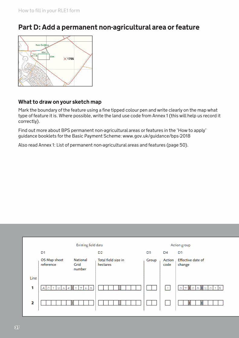
Part D: Add a permanent non-agricultural area or feature
What to draw on your sketch mapMark the boundary of the feature using a fine tipped colour pen and write clearly on the map what type of feature it is. Where possible, write the land use code from Annex 1 (this will help us record it correctly).
Find out more about BPS permanent non-agricultural areas or features in the ‘How to apply’ guidance booklets for the Basic Payment Scheme: www.gov.uk/guidance/bps-2018
Also read Annex 1: List of permanent non-agricultural areas and features (page 50).
How to fill in your RLE1 form

38
To add a feature to the land parcel correctly, fill in the following columns on the RLE1 form, Part D: Field transfers and boundary changes.
D1 – Existing Ordnance Survey Map sheet reference and National Grid numberFill in the Ordnance Survey Map sheet reference and the National Grid number of the land parcel(s) to which you are adding the feature.
D4 – Action CodeFill in the action code ‘I’ for a feature.
D5 – Effective date of changeFill in the effective date of change, which is the date when the change took place or will take place.
You must read the relevant Natural England guidance or Forestry Commission guidance ON42 to find the appropriate effective date of change if you intend to register a non-agricultural area to claim under:
• Rural Development Programme funding or land within the National Forest Changing Landscape scheme, or
• Woodland Carbon Fund or HS2 Woodland Fund and you claim that land under BPS.
How to fill in your RLE1 form

39
Part D: Remove a permanent non-agricultural area or feature
What to draw on your sketch mapIf you want to remove a permanent non-agricultural area or feature from your maps, put a cross through the feature and write clearly on the map that you want to remove it.
Find out more about BPS permanent non-agricultural areas or features in the latest BPS rules.
How to fill in your RLE1 form

40
To remove the feature from the land parcel correctly, fill in the following columns on the RLE1 form, Part D: Field transfers and boundary changes.
D1 – Existing Ordnance Survey Map sheet reference and National Grid numberFill in the Ordnance Survey Map sheet reference and the National Grid number of the land parcel(s) you are removing the feature from.
D4 – Action CodeFill in the action code ‘I’ for a feature.
D5 – Effective date of changeFill in the effective date of change, which is the date when the change took place or will take place.
If the feature never existed or the date of the change is unknown, leave the date field blank.
How to fill in your RLE1 form

41
Part D: Change land cover
What to draw on your sketch mapWrite ‘Land cover change’ at the top of your sketch map. Clearly label the land parcel with the new land cover (arable land, permanent grassland, permanent crops or non-agricultural). If the land cover is non-agricultural, write the land use code from Annex 1 (this will help recorde it correctly).
If there is more than one land cover in the land parcel you must clearly mark the areas of each land cover using a fine tipped colour pen. It would help us to register the different areas within the land parcel correctly, if you give us the measurements of the areas from a clearly defined point, such as a corner along an existing boundary and where it lies in relation to other boundaries. Label each area on your map to clearly show the new land cover.
How to fill in your RLE1 form
42
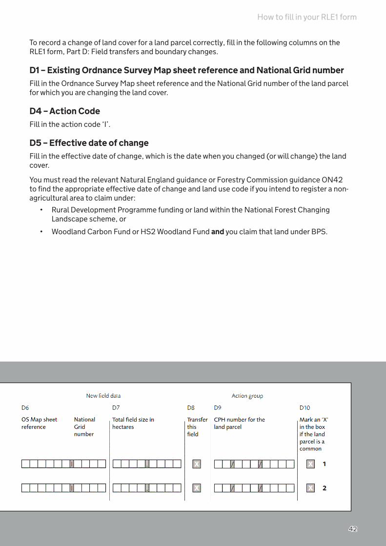
To record a change of land cover for a land parcel correctly, fill in the following columns on the RLE1 form, Part D: Field transfers and boundary changes.
D1 – Existing Ordnance Survey Map sheet reference and National Grid numberFill in the Ordnance Survey Map sheet reference and the National Grid number of the land parcel for which you are changing the land cover.
D4 – Action CodeFill in the action code ‘I’.
D5 – Effective date of changeFill in the effective date of change, which is the date when you changed (or will change) the land cover.
You must read the relevant Natural England guidance or Forestry Commission guidance ON42 to find the appropriate effective date of change and land use code if you intend to register a non-agricultural area to claim under:
• Rural Development Programme funding or land within the National Forest Changing Landscape scheme, or
• Woodland Carbon Fund or HS2 Woodland Fund and you claim that land under BPS.
How to fill in your RLE1 form

43
Part D: Add hedges and trees in a line
How to check your digital maps for hedges and trees in a lineCheck your digital maps in the Rural Payments service. Make sure the hedge layer is switched on so you can check which boundaries are shown with hedges. You only need to add hedges and trees in a line if you can’t see them on your digital maps and you are claiming them under a Rural Payments scheme. Read the latest scheme rules for more information about including hedges in your claim(s). If you need to add hedges and trees in a line to your digital maps, print a copy of the relevant map(s) with the hedge layer visible and follow the instructions below.
What to draw on your sketch mapMark the boundary of the hedge or trees in a line using a fine tipped colour pen and write clearly on the map if this is a hedge or trees in a line. You also need to clearly state the length of the hedge or trees in a line.
Read the latest BPS rules for more information about hedges and trees in a line: www.gov.uk/rpa/bps.
How to fill in your RLE1 form

44
To add a hedge or trees in a line to a land parcel correctly, fill in the following columns on the RLE1 form, Part D: Field transfers and boundary changes.
D1 – Existing Ordnance Survey Map sheet reference and National Grid numberFill in the Ordnance Survey Map sheet reference and the National Grid number of the land parcel(s) to which you are adding the hedge or trees in a line.
D4 – Action CodeFill in the action code ‘H’ for the boundary feature change.
D5 – Effective date of changeFill in the effective date of change, which is the date when the change took place or will take place. If the hedge or trees in a line have always been part of the boundary, use 1 January 2018 as the effective date.
How to fill in your RLE1 form

45
Part D: Multiple changes to a land parcel
What to draw on your sketch mapIf you want to make several changes to one land parcel, mark the new boundaries and other features you want to change in the land parcel, following the information earlier in this section.
To record all changes correctly, fill in the following columns on the RLE1 form, Part D: Field transfers and boundary changes.
D1 – Existing Ordnance Survey Map sheet reference and National Grid numberFill in the Ordnance Survey Map sheet reference and the National Grid number of the land parcel(s) you want to change.
D2 – Total field size in hectaresFill in the total land parcel area in hectares, to 4 decimal places.
D3 – Group
If you want us to make several changes to one land parcel use the group column to show the change is part of a number (group) of changes to be made on the land parcel.
How to fill in your RLE1 form

46
You don’t need to fill in the Ordnance Survey Map sheet reference and National Grid number on every line. Give your own two digit number, for example, 01, 02 or 03 to act as a group code. Use the same group code for each change to that land parcel.
D4 – Action CodeFill in the relevant action code, for example ‘C’ or ‘D’ or ‘I’ or ‘N’.
D5 – Effective date of changeFill in the effective date of change, which is the date when the change took place or will take place.
If the feature never existed or the date of the change is unknown, leave the date field blank.
D6 – New Ordnance Survey Map sheet reference and National Grid numberFill in the estimated new Ordnance Survey sheet references and National Grid numbers of any new land parcel(s).
For more information about how to estimate a land parcel reference number read page 60.
D7 – Total field size in hectaresFill in the new estimated areas for the new split land parcels, to 4 decimal places – your best estimate.
D8 – Transfer this fieldIf you are removing/adding a land parcel and it is being transferred to another person or business, put an ‘X’ in the Transfer this field column. If you are removing/adding a land parcel and it is not a transfer, leave this column blank.
D9 – CPH for the land parcelIt is no longer mandatory to fill in CPH numbers on the RLE1 form.
How to fill in your RLE1 form

47
Part E – Supporting documentsIf you are sending supporting documents with your RLE1 form, we need to know what you have included. If you are not sending any supporting documents, please ignore Part E.
E1 - Fill in the number of each type of supporting documents that you are sending to us.The following maps are acceptable supporting documents:
• RPA maps
• Ordnance Survey/professionally drawn maps
We can’t return documents to you and we strongly recommend that you keep a copy of your completed RLE1 form for reference, as well as copies of any maps and supporting documents that you are sending with the RLE1 form.
How to fill in your RLE1 form

48
How to fill in your RLE1
Part F – Your declaration and responsibilitiesYou must read the declaration and responsibilities carefully before signing the RLE1 form.
Remember to:
• use capital letters
• sign and date the RLE1 form
• make sure that you have the correct permission level to sign the RLE1 form. Read page 2 for the list of appropriate permission levels
• sign in your own name - the RLE1 form must not be signed in the name of the business
• give your customer reference number (CRN) if you have one, or explain your relationship to the beneficiary
RPA will reject your RLE1 if you cross out or deface the declaration and responsibilities in Part F.

49
Send your RLE1 form to RPASend your completed RLE1 form(s), maps and other supporting documents to:
Rural Payments AgencyPO Box 352WorksopS80 9FG
To transfer entitlements or land for a specific scheme year, we must receive your RLE1 form by midnight on the application deadline. Read the rules for the scheme(s) you’re applying for to check when the application deadline is.
If you send your RLE1 form by post, please make sure you pay the correct amount of postage for the size and weight of your envelope - Royal Mail may return letters with insufficient postage, or it may take longer. The envelope may need more stamps than the usual first or second class delivery charge, especially if you are including supporting documents.
We will let you know when we’ve received your RLE1 form by sending you an acknowledgement card. The acknowledgement card is proof of receipt so please keep it.
Changing or withdrawing your RLE1 formOnly the person who signed the RLE1 form can change or withdraw it. They can do this up to the day before the ‘effective date’.
If we have already rejected your RLE1 form because it was not valid, you can’t change or withdraw it. You may choose to fill in and send a new RLE1 form to us.
Call the Rural Payments helpline on 03000 200 301, or email [email protected], or write to us at the above address.
We will contact only the farmer or business making the change to confirm that we have accepted their request.
RPA’s basic check of RLE1 formsWe carry out a basic check on any RLE1 forms you send to us, as follows:
Part A General details
• Is there a nine digit SBI number present?
Part F Your declaration and responsibilities
• Have any of the declarations or responsibilities been amended in any way?
• Has the form been signed and a name entered on the form?
We will reject an RLE1 form and return it with a letter if part A and F are not completed correctly, or part F has been amended in any way. If we require further information on sections B, C and D, we will contact you and request this information before processing the RLE1 form.
Send your RLE1 form to RPA
50
Annex 1 - List of permanent non-agricultural areas and featuresAll the features and areas appearing in this list must be mapped for your registered land parcels, regardless of which scheme you apply for. This applies whether they form part of the parcel boundary or are ‘in-field’ features.
If we have already mapped the areas or features, you don’t need to tell us about them again. If we haven’t, you need to fill in an RLE1 form.
Agricultural buildings
Land use Definition Land use code
Farm building A building used for livestock husbandry, cultivation or the storage of crops, feed and machinery, and associated residences, ie farmhouses.
AB01
Farmyard The open ground, generally of hard standing or compacted earth, surrounding farm buildings.
AB09
Glasshouse, including polytunnels
This code should be used for glasshouses on a hard standing. For BPS, also use this code if the glasshouse is being used to grow ineligible crops.
A horticultural building constructed largely of glass, which is on a hard standing or used to grow ineligible crops.
The area of a glasshouse that is on a natural surface and is being used to grow eligible crops should be declared using the land use of the eligible crops.
AB06
Banks, hedges and stone walls not protected under cross compliance
Land use Definition Land use code
Non-utilised Bank This code should only be used for banks which are inaccessible or not protected under cross compliance.
A bank is a raised linear feature that is artificially constructed and predominantly made up of earth. A bank can have a vegetated, bare earth or stone surface.
PL01
Annex 1 - List of permanent non-agricultural areas and features
51
Banks, hedges and stone walls not protected under cross compliance continued
Land use Definition Land use code
Stone wall This code should only be used for stone walls which are not protected under cross compliance.
Stone walls protected under cross compliance should be coded using the land use code for the main land use of the parcel.
A stone wall is a wall structure built with stones, traditionally with loose field stones and mortar.
BB01
Coastal features
Land Use Definition Land use code
Cliff A feature representing a steep rock face, most commonly occurring where the land meets the sea. Cliffs may be semi-natural, in the case of disused mineral workings, or man-made in the case of rock faces resulting from construction activity.
CF01
Sand dunes An area of sand dunes (ridges of sand created by the wind).
CF03
Vegetated shingle An area of water-worn pebbles which supports growth of vegetation.
CF02
Cultivated and managed features
Land use Definition Land use code
Peat production This code should only be used for an area of land which is permanently used for peat production. An area of land is permanently used for peat production if the production has taken (or will take) place for 3 years or more.
Peat production is an area of land used for peat extraction.
CM01
Annex 1 - List of permanent non-agricultural areas and features

52
Land use Definition Land use code
Turf production This code should only be used for a site which is permanently used for the production of turf for fuel. A site is permanently used for the production of turf for fuel if the production has taken (or will take) place for 3 years or more.
Turf for later replanting will be considered part of the agricultural area of the land parcel and should be coded as either permanent grassland or temporary grassland.
Turf production is a site used for the production of turf, a surface layer of earth containing a dense growth of grass and its roots.
CM02
Heaps
Land use Definition Land use code
Heap A permanent pile of farm produce or refuse, for example straw, manure, compost, hay or silage. A heap is permanent if it has been kept at the same location for 3 years or more.
HE03
Inland water and wetland features
Land use Definition Land use code
Bog An area of land which is normally waterlogged throughout the year and consists of spongy moss and peat. Bogs most often occur in low lying flat areas with poor drainage, and in upland areas of high
IW07
Fen, marsh and swamp An area of low and flat waterlogged land. IW06
Shingle An area of small rounded pebbles. IW05
Watercourse – ditch, drain or dyke
This code should only be used for a drain, ditch or dyke which is inside the land parcel and is not part of the parcel boundary.
A drain, ditch or dyke is an artificial channel used to carry excess water from low-lying areas.
WF01
Annex 1 - List of permanent non-agricultural areas and features

53
Land use Definition Land use code
Watercourse - river or stream (Rivers and Streams Type 2)
This code should only be used for a river or stream which:
• is inside the land parcel and is not part of the parcel boundary
• is less than 4 metres wide over the majority of its length
A river or stream is a body of water flowing in a definite channel towards the sea, a lake or into another river.
IW02
Watercourse - river or stream (Rivers and Streams Type 3)
This code should only be used for a river or stream which:
• is inside the land parcel and is not part of the parcel boundary
• is greater than, or equal to, 4 metres wide over the majority of its length
A river or stream is a body of water flowing in a definite channel towards the sea, a lake or into another river.
IW03
Man-made transport, surfaces, storage areas and utility features
Land use Definition Land use code
Airstrip/airports Airstrip – a stretch of land which has been cleared so that light aircraft can take off and land. The area is defined by the edges of the landing strip.
Grass air strips which are only used for part of the year on land which is normally agricultural should be declared as agricultural land.
Airport – an area of land where aircraft land and take off and which provides facilities for handling passengers, air freight and servicing aircraft.
MT05
General Utility A type of permanent infrastructure on land that is not covered by other utility classifications. Examples include water tanks and butts.
UT06
Hard standing A man-made, open ground surface built using aggregate, concrete-type construction materials.
HS01
Mineral extraction site A site used for mineral extraction. Includes both currently operational and disused sites.
MS04
Railway Steel bars or a continuous line of bars laid on the ground, usually forming a track used for the movement of trains.
MT04
Annex 1 - List of permanent non-agricultural areas and features
54
Land use Definition Land use code
Road A metalled or surfaced way that is clearly marked, permanent and forms part of a wider road network with, for example, road markings, road names or road numbers.
MT03
Scattered man-made features
Any man-made features which are scattered in a land parcel.
This code should be used only for scattered features within a land parcel which are too small to map individually but which – when added together – have a combined area of 0.01 ha or greater. Scattered features are also referred to as ‘notional features’.
NF07
Solar panels An area taken up by solar panels and solar panel arrays
Land parcels which contain solar panels are ineligible for BPS. If the panels are concentrated in one end of a field, the rest of the land can be eligible if the 2 areas are registered as individual land parcels and separated by a permanent boundary.
UT01
Structure A manmade structure that is not described under any other land use code. Examples include animal shelters or polytunnels on a hard standing.
ST05
Manmade track (Metalled) A metalled or surfaced way that is clearly marked and permanent. Includes any manmade surface, such as areas of asphalt, concrete and gravel.
MT01
Water treatment works A site where water is treated and supplied. UT07
Marine wetland features
Land use Definition Land use code
Intertidal habitats An area of sand or mud uncovered at low tide. MW04
Reed bed This code should only be used for reed beds which are not kept in a state suitable for grazing or are in an area where grasses and other herbaceous forage are not predominant.
Grazeable reed beds in an area where grasses and other herbaceous forage remain predominant should be coded as permanent grassland.
A reed bed is an area of tall, stiff marsh or water grass of various kinds.
MW03
Saline habitats A coastal area with a sodium chloride content of at least 0.5%.
MW05
Annex 1 - List of permanent non-agricultural areas and features

55
Land use Definition Land use code
Salt marsh This code should only be used for salt marshes which are not kept in a state suitable for grazing or are in an area where grasses and other herbaceous forage are not predominant.
Grazeable salt marsh in an area where grasses and other herbaceous forage remain predominant should be coded as permanent grassland.
Salt marsh is an area of coastal grassland which is frequently inundated by the sea.
MW01
Tidal areas Tidal areas other than salt marshes. MW02
Mixed, scattered non-agricultural features
Land use Definition Land use code
Scattered features - mixed This code can be used for a combination of more than one type of the scattered features described in this table.
This code should only be used only for scattered features within a land parcel which are too small to map individually but which – when added together – have a combined area of 0.01 ha or greater. Scattered features are also referred to as ‘notional features’.
NF08
Scattered natural features Natural features that are scattered in a land parcel, are not kept in a state suitable for grazing or cultivation, are not protected under cross compliance, and are not included under any other land use codes.
This code should only be used only for scattered features within a land parcel which are too small to map individually but which – when added together – have a combined area of 0.01 ha or greater. Scattered features are also referred to as ‘notional features’.
NF06
Natural transport features – tracks and gallops
Land use Definition Land use code
Gallop A track with a grass or manmade surface that is used for horses to gallop on when being trained for horse racing.
Grass gallops can exceptionally be considered part of the agricultural area of a land parcel but only if the applicant can prove that the non-agricultural activity does not significantly interfere with agricultural
NT01
Annex 1 - List of permanent non-agricultural areas and features

56
Land use Definition Land use code
Track – natural surface This code should only be used for a natural, unsurfaced track or path which is not used as part of the agricultural activity carried out on the land parcel or is part of a transport network entering and exiting the land parcel.
Natural paths and tracks which are used as part of the agricultural activity carried out on the land parcel and are not part of a transport network entering and exiting the land parcel should be coded using the land use code for the main land use of the parcel.
NT03
Recreational and non-recreational buildings, and recreational land
Land use Definition Land use code
Golf course Bunkers, greens, fairways and areas of rough that are part of the playing course. Includes putting greens and driving ranges.
Golf courses can exceptionally be considered part of the agricultural area of a land parcel, but only if the applicant can prove that the non-agricultural activity does not significantly interfere with agricultural activity.
RL04
Residential dwelling, house Residential dwellings, including domestic outbuildings.
NR01
Residential garden A garden making up part of a residential dwelling. WO17
Sports and recreation An area of land used for permanent sports and recreational activities.
RL03
Rocky features
Land use Definition Land use code
Boulders An area of large, rounded rocks that are weathered or water-worn and have a diameter that is greater than 0.2 metres.
RO03
Cliff A feature representing a steep rock face, most commonly occurring where the land meets the sea. Cliffs may be semi-natural, in the case of disused mineral workings, or man-made in the case of rock faces resulting from construction activity.
CF01
Rocky outcrop A protrusion of rocks above the ground in a conspicuous form.
RO04
Annex 1 - List of permanent non-agricultural areas and features

57
Land use Definition Land use code
Scattered rock Any naturally occurring scattered elements of a rocky nature. Includes small outcrops, areas of shingle or scree, small boulders, etc.
This code should only be used only for scattered features within a land parcel which are too small to map individually but which – when added together – have a combined area of 0.01 ha or greater.
Scattered features are also referred to as ‘notional features’.
NF01
Scree A mass of loose stones on the side of a steep rock face.
RO02
Storage areas
Land use Definition Land use code
Storage area An area of bare earth which is used for storage purposes. Includes storage of farm-related machinery, hay bales, etc.
SA02
Trees, foliage, scrubland, woodland and forestry
Land use Definition Land use code
Bracken, heather and heathland
Bracken - this code should only be used for an area of bracken which is not kept in a state suitable for grazing or is in an area where grasses and other herbaceous forage are not predominant.
Grazeable bracken in an area where grasses and other herbaceous forage remain predominant should be coded as permanent grassland.
Bracken is an area covered predominantly by a type of fern (Pteridium aquilinum) found together with other species in heathland or hill sides. See also ‘Scattered bracken or heather’.
Heather - this code should only be used for an area of heather which is not kept in a state suitable for grazing.
Grazeable heather should be coded as permanent grassland.
Heather is an area covered predominantly by common heather and various species of the Cassiope or Erica genus. See also ‘Scattered bracken or heather’.
HE02
Annex 1 - List of permanent non-agricultural areas and features

58
Trees, foliage, scrubland, woodland and forestry continued
Land use Definition Land use code
Scattered bracken or heather Scattered bracken - areas of bracken which are scattered in a land parcel, are not kept in a state suitable for grazing or are in an area where grasses and other herbaceous forage are not predominant.
Scattered bracken which is grazeable and in an area where grasses and other herbaceous forage remain predominant should be coded as permanent grassland.
Scattered heather - areas of heather which are scattered in a land parcel and are not kept in a state suitable for grazing.
Scattered heather which is grazeable should be coded as permanent grassland.
This code should be used only for scattered features within a land parcel which are too small to map individually but which – when added together – have a combined area of 0.01 ha or greater. Scattered features are also referred to as ‘notional features’.
NF02
Scattered scrub This code should only be used for patches of scrub which are scattered in a land parcel and are not kept in a state suitable for grazing or are in an area where grasses and other herbaceous forage are not predominant. Includes patches of scrub which are too dense to be grazed.
Scattered scrub which is grazeable and in an area where grasses and other herbaceous forage remain predominant should be coded as permanent grassland.
This code should only be used only for scattered features within a land parcel which are too small to map individually but which – when added together – have a combined area of 0.01 ha or greater. Scattered features are also referred to as ‘notional features’.
NF03
Scrub This code should only be used for scrub which is not kept in a state suitable for grazing or is in an area where grasses and other herbaceous forage are not predominant. Includes scrub which is too dense to be grazed.
Grazeable scrub in an area where grasses and other herbaceous forage remain predominant should be coded as permanent grassland.
Scrub is an area of shrubs and bushes, including Rhododendrons, Gorse, Briar and Broom.
WO25
Annex 1 - List of permanent non-agricultural areas and features
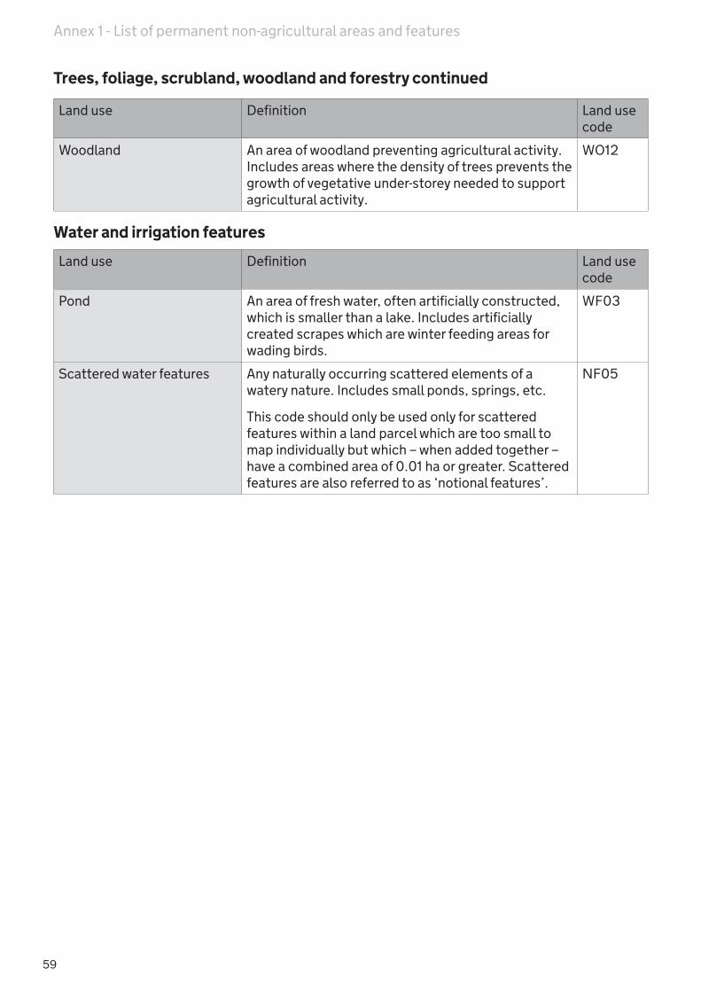
59
Trees, foliage, scrubland, woodland and forestry continued
Land use Definition Land use code
Woodland An area of woodland preventing agricultural activity. Includes areas where the density of trees prevents the growth of vegetative under-storey needed to support agricultural activity.
WO12
Water and irrigation features
Land use Definition Land use code
Pond An area of fresh water, often artificially constructed, which is smaller than a lake. Includes artificially created scrapes which are winter feeding areas for wading birds.
WF03
Scattered water features Any naturally occurring scattered elements of a watery nature. Includes small ponds, springs, etc.
This code should only be used only for scattered features within a land parcel which are too small to map individually but which – when added together – have a combined area of 0.01 ha or greater. Scattered features are also referred to as ‘notional features’.
NF05
Annex 1 - List of permanent non-agricultural areas and features

60
Annex 2 - How to estimate a land parcel reference number
Estimating the centroid of a field - finding your sheet reference
The unique reference number is comprised of the Ordnance Survey (OS) sheet reference and the National Grid (NG) field number. It is important that you use the correct OS sheet reference for each field entered on the land registration form. The sheet reference number must always consist of just 2 letters and 4 numbers that represent the 1km square within which your field parcel lies. This must be the 1:2,500 sheet number which, if not available can be derived from a 1:10,000 map.
Sheet reference letters The SP grid square split into 10km squares
Each 10km square is split into 1km squares
The UK is divided into 100km grid squares with individual letters.
Identify the square your fields is in. This forms the first part of your sheet reference.
100km 10km
Each grid square is split into 10km squares that are numbered.
The reference for the grey 10km square shown is SP47.
The reference for the grey 1km square shown above is SP4178.
The extent of the 1:2,500 map is outlined above (two 1km grid squares). The extent of a 1:10,000 map is shown (dotted)
NB: Use the numbers on the bottom of the map first (the eastings), then the numbers up the side (the northings) to make the sheet reference numbers. The best way to remember this is “along the corridor and up the stairs”
Put the sheet letters + the 2 eastings numbers + the 2 northings numbers together to make your sheet reference.
Estimating the centroid of a field - finding your field number
To generate a unique field number, first estimate by eye and mark as a dot or cross on the map the centre point of your field. To identify your field parcel centre numbers you will need a ruler and pencil to draw lines from the map edge to the field centre (see dashed lines on the two diagrams below)
Below is the South West corner of a 1:10,000 map. The map is divided into squares at 1km (1000 metre) intervals. These squares will measure 10cm on your map.
1km(1000m)
100m
Below is the South West corner of a 1:2,500 map. The map is divided into squares at 100 metre intervals. These squares will measure 4cm on your map.
The centre of the field marked above is 630 metres along the bottom (the eastings) and 320 metres up the side (the northings) from the South West corner of the map. The field number is made up of the first two digits of each number - 63 32.
The centre of the field marked above is 150 metres along the bottom (the eastings) and 70 metres up the side (the northings) from the South West corner of the map. The field number is made up of the first two digits of each number - 15 07.
Annex 2 - How to estimate a land parcel reference number

61
Annex 3 - Counting slopes when measuring total field sizeUp until 2017 we accepted three dimensional measurements of the areas of land parcels to account for the additional area of sloping land, when accompanied by a detailed, independent professional survey.
As this practice did not meet EU regulations or requirements we stopped accepting these surveys, to account for sloping land, from 2017.
Land parcels previously surveyed and their three dimensional maximum area eligible values accepted by us will remain valid unless other land changes are required, when the area will revert to a two dimensional area.
Annex 3 - Counting slopes when measuring total field size

62
More informationContact us All written queries, forms and maps should be sent to:
Rural Payments AgencyPO Box 352 Worksop S80 9FG
Email: [email protected]
Call: 03000 200 301 open 8.30am to 5pm Monday to Friday (except Bank Holidays).
For any changes to our opening times, please check on our website at www.gov.uk/rpa
Website: www.gov.uk/rpa. Twitter: @Ruralpay
When you contact us please give your Single Business Identifier (SBI) and your business name.
If you’re deaf, deaf blind, deafened, hard of hearing or speech impaired and have a text phone, you can use Text Relay (previously known as Type Talk). This is a telephone relay service that means you can communicate with hearing people by telephone.
To contact us using Text Relay, dial 18001 03000 200 301 from your text phone. To use text relay on a device such as a smartphone or computer you also need to download the free Next Generation Text app from www.ngts.org.uk or from a marketplace such as Google Play or the App Store.
You can make a text relay call in a number of different ways and using a number of different devices. For more information go to www.ngts.org.uk
To receive this guidance in large print, or another alternative format, contact us.Other useful contactsDefra helpline: 0345 933 5577
Forestry Commission national office: 0300 067 4000
Natural England: 0300 060 6000
How to complain Farmers or agents who are unhappy with a decision or service they’ve had from us, can call, email or write to us.
For contact details and more information about how to complain or appeal go to www.gov.uk/rpa and click on ‘Complaints procedure’ in the ‘Corporate Information’ section.
Data Protection Defra is the data controller for personal data you give to us or we hold about you. We use it in line with the Data Protection Act. For more information, go to www.gov.uk/rpa, choose ‘Contact RPA’ and click on ‘Personal information charter’.
More information

© Crown copyright 2018
You may re-use this document (not including logos) free of charge in any format or medium, under the terms of the Open Government Licence v3.0. To view this licence visit http://www.nationalarchives.gov.uk/doc/open-government-licence; or write to the Information Policy Team, The National Archives, Kew, Richmond, Surrey, TW9 4DU or email: [email protected]
This document is also available on our website at www.gov.uk/rpa/bps2018
www.gov.uk/rpa
Produced by the Rural Payments Agency
Version 1.0
March 2018