rse, edi r - umass amherst publications... · j " i l 1 i rse, edi r r/v pitsiulak...
TRANSCRIPT
J
1I L""
I
RSE, EDI R
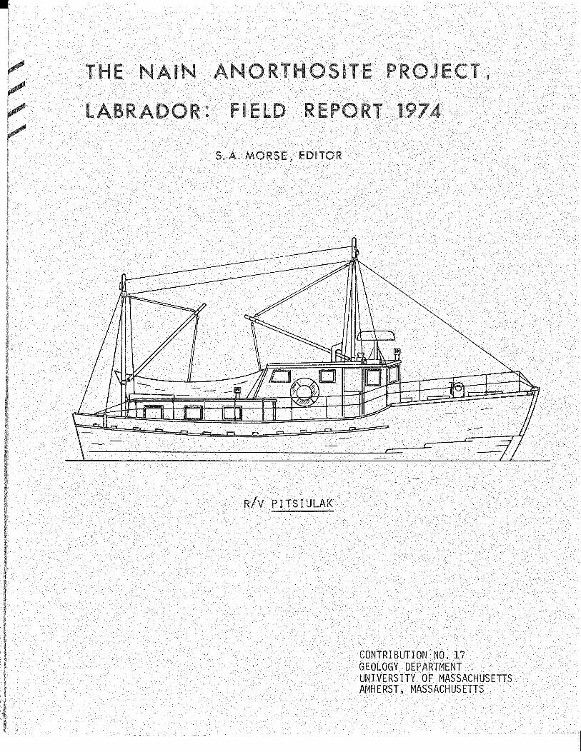
R/V PITSIULAK
CONTRIBUTION NO.GEOLOGY DEPARTMENTUNIVERSITY OF MASSACHUSETTSAMHERST, MASSACHUSETTS.

JAMES seOATES
THE NAIN ANORTHOSITE PROJECT, LABRADOR:
FIELD REPORT 1974
S. A. Morse, Editor
Interim Report under NSF Grant GA-4l256X
"Evolution of anorthosite and related
crustal rocks in coastal Labrador."
S. A. Morse, Principal Investigator
Dirk de Waard )) Associate Investigators
E. P. Wheeler 2nd)
Field Investigators:
University of Massachusetts, Amherst
Syracuse University
Cornell University
J. H. Berg, UMass/Amherst
Stephen Brand, Purdue
H. M. Davies, UMass/Amherst
Research Assistants:
D. E. Deuring, Dartmouth
Susan Hancock, Mount Holyoke
Barbara Harrington, Mount Holyoke
Contribution No. 17Geology DepartmentUniversity of Massachusetts
E. C. Simmons, SUNY/Stony Brook
J. A. Speer, V.P.I. and S. U. /Blacksburg
R. A. Wiebe, Franklin and Marshall
R. W. Wiener, UMass/Amherst
J. C. Huntington, UMass/Amherst
D. W. Keith, FranRlih and Marshall
A. R. Prunier, V.P. I. and S.U./Blacksburg
C. R. Thornber, UMass/Amherst
Amherst, Massachusetts
January, 1975

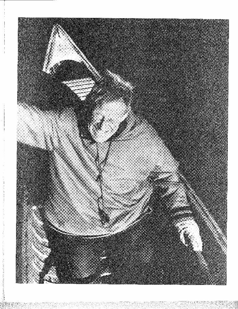
E. P. Wheeler 2nd
1900 - 1974
(Wyatt Harbour, 1972)

iii
Everett Pepperrell Wheeler 2nd
This quietly spectacular man died on 30 October 1974, at his horne
in Blue Mountain Lake, New York. Those who knew him will readily compre
hend the enormous loss which his passing brings to the members of this
Project, as well as the irony of his terminal illness; Stefansson's book
"Cancer, Disease of Civilization" was glaringly prominent in the living
room bookshelf during his last days.
This is not the place for a biographical memorial, but it is fitting
to record here some highlights of his contributions to Labrador geology.
In his early travels he discovered a major river in central Ungava which now,
along with a mountain, justly bears his name; his early topographic maps
were invaluable to surveyors and visitors for several decades.
The scale of Pep Wheeler's life-work can only be described in heroic
terms: the territory he mapped in 48 years covers something like 27,000
square kilometers. This is equivalent to 48 fifteen-minute quadrangles at
the latitude of the Adirondacks. (He always said if he couldn't average
a quadrangle a year he was falling behind. It is nice to know he carne out
even.) Until the post - WW II period brought aerial photography, his base
maps were the product of his own surveying; even later, the restricted
photo coverage of inland areas forced the continuation of his" topographic
mapping. After wartime service with the Corps of Engineers, he returned,
now with his wife Eleanor, to a 3-year cycle of summer-winter-summer in the
field, followed by laboratory work at horne in Ithaca for winter-summer-winter.
Winter work in the field was often concentrated in the upl~nds1 where triang
ulation nets could be extended and wind-blown outcrops examined and sampled.
"There is more outcrop exposed there in the winter than in the eastern U.S.
south of the glaciated area at any time," he would say. The resulting
geologic manuscript map covers a large wall at a scale of one mile to the
inch. Small-scale versions were printed in 1960 and 1968, and a new version
at 1:500,000 is available in ozalid. The detailed map appears to be the only
one in the world covering a large anorthosite complex; it is unique also in
containing much petrographic information (Johannsen families, An and En
values) .
Wheeler's typewritten field notes fill 14 large loose-leaf notebook
binders, and thin section descriptions occupy an equal amount of shelf

iv
space. He worked more for posterity than for himself. Specimens and
sections have already yielded several important papers by or with others,
notably those of Smith (e.g. J. Petrology, 1974, p. 58) and a fascinating
new contribution on osumilite by Berg and Wheeler (see abstract in this
volume). Chemical analyses were accumulated slowly over the years,
eventually giving rise to the first comprehensive statement, with de
Waard, of the chemistry of what he finally carne to call simply the Nain
complex. His description of this complex (1942) was the first, and in
comparing the page-sized map of 1942 with current versions; it is interest
ing to note how much of what we find important today is already there -
for example, the Snyder Group, the Barth Island complex, the Barth-Newark
dike, the Kiglapait intrusion, and the two large western adamellite
bodies are all discernible. This early report was followed in 1955 by a
major paper on the adamellites, and then by a succinct review of the
whole complex in 1960.The messages in these and later papers were never strident, often
hesitant, and on occasion occult, for he did not wish to overcall his
hand or outrun his data. But his work was full of insights, many of
which he recognized when they carne back to him freshly perceived by one
of us. Aided by his superbly organized notes, his recall of what he had
seen was phenomenal, and his comprehension of its importance impressive.
In the heady weekend-long winter gatherings of what he dubbed the Mountain
and Muskeg Society in Canton, Ithaca, and Blue Mountain Lake, and later
in the even more exhilarating days of discovery and argument aboard the
vessel which he named Pitsiu~ak, many a wild idea was brought up short on
the hard fact of his experience, and many a good idea -tras --tested to the
hilt against his comprehensive knowledge. His perceptions were never
ruled by preconceptions. He was flexible and resilient, but dogged in
pursuit of disturbing evidence of all sorts in the rocks.
No man who was not sensitive to his natural and humad surroundings
could have survived a half-century of productive research and travel in
Labrador. Like S.tefansson in his analytic observation, and in many ways
like Rasmussen in his rapport with the Inuit, he was both an articulate
"survivor" and the object of deep affection and respect among the people
of Labrador. He could name the plants and animals -- all of them, it
seemed -- and direct you to the mushrooms of the week. He was the sort
v
of gourmet, both at home and abroad, who could concoct the "Nain Gourmet's
Almanac" reproduced in FR 1971. He was a classicist, but more importantly
a romantic. When visiting with him, especially at home with Eleanor, it
was easy to forsake geology for the delights of literature, ballet, film,
history, travel, and a remarkable wine cellar.
This Project literally owes its existence to Pep Wheeler and his
work. He rejoiced in the chance for continued field work, and even more
in the opportunity to help young people get started in it. For him it was
by no means enough to survive in a rigorous environment; one should learn
to live graciously. It was his pleasure to spend a few weeks with the
early crews each season, helping them by example to become comfortable,
and helping them with relish to become ensnared in the baffling but exquis
itely displayed field relations of the rocks. It was then his custom to
visit special problem areas with the vessel, and afterward to spend sev
eral weeks by himself in a remote, physically demanding, and appallingly
difficult field area. It will be a long while before some of this ground
is covered again; not all the powers of the space age can substitute for
his kind of field work.
The members of the Project were alway~ aware of their privilege in
working and learning with this gentle man. He repaid their love many
times over. And as Emerson once said of another, "How little this man
suspects, with his sympathy for men and his respect for lettered and
scientific people, that he is not likely, in any company, to find a man
superior to himself. And I think this is a good country that can bear
such a creature as he is."
-- S.A. Morse

<
vi
Bibliography of E. P. Wheeler 2nd
1927a Olivine from Monhegan Island, Maine: Am. Mineralogist, v. 12, p. 260-261.
1927b Stellerite from near Juneau, Alaska: Am. Mineralogist, v. 12, p. 360-364.
1930 Journeys about Nain: winter hunting with the Labrador Eskimo: Geogr.Rev., v. 20, p. 454-468 and one plate.
1933 A study of some diabase dikes on the Labrador coast: J. Geol., v. 41,p. 418-431.
1935a An amazonite aplite dike from Labrador: Am. Mineralogist, v. 20, p. 44-49.
1935b The Nain-Okak section of Labrador: Geogr. Rev., v. 25, p. 240-254 andone plate.
1938 Topographical notes on a journey across Labrador: Geogr. Rev., v. 28,p. 475-481.
1942 Anorthosite and associated rocks about Nain, Labrador: J. Geol. v. 50,p. 611-642.
1950 Massive leucoxene in Adirondack titanium deposit: Econ. Geol., v. 45,p. 574-577.
1953b Notes on pinnipedia: J. Mammology, v. 34, p. 253-255.
1953a List £f Labrador Eskimo Place Names: Nat. Mus. Canada, Bull. 131, 105 p.
1971a (with D. de Waard) Chemical and petrologic trends in anorthositic andassociated rocks of the Nain massif, Labrador: Lithos, v. 4, p. 367-380.
Anorthosite - adamellite complex of Nain, Labrado.~ £eo1. Soc. AmericaBull., v. 71, p. 1755-1762.
1960
1968a (with G.M. Boone) Staining for cordierite and feldspars in thin section:Am. Mineralogist, v. 53, p. 327-331.
1965 Faya1itic olivine in northern Newfoundland-Labrador:~Canad. Mineralogist,v. 8, p. 339-346.
1968b Minor intrusives associated with the Nain anorthosite: in Isachsen, I.W. (ed.), New York State Mus. and Sci. Servo Mem. 18, p.~89-206.
1958 Pleistocene glaciation in Northern Labrador: Geol. Soc. America Bull.,v. 69, p. 343-344.
1955 Adamellite intrusive north of Davis Inlet, Labrador: Geol. Soc. AmericaBull., v. 66, p. 1031-1060.
1964 Unmetamorphosed sandstone in northern Labrador: Geo1. Soc. America Bull.,v. 75, p. 569-570.

vii
1971b Notes in Nain Field Report 1971:Intrusive contact relations in the outer islands: p. 27-28.Giant pyroxenes: p. 66-67.Nain Gourmet's Almanac: p. 96a.
1972 (with R.F. Emslie and S.A. Morse) Igneous rocks of central Labrador,with emphasis on anorthositic and related intrusions: 24th Int.Geol. Cong., Guidebook A54, 72 p.
1973 Articles and notes in Nain Field Report 1972:Anorthosite field relations in the outer islands:Anorthosite-adamellite contact on Zoar Peninsula:Giant pyroxenes in anorthosite: p. 96-102.Deformational history of the Ford Harbour Formation
p. 30-36.p. 81-82.
(with Morse): p. 117
1974a Articles and notes in Nain Field Report 1973:Archaean anorthosite in Labrador (with Hurst and others): p.9-l7.Plutonic and metamorphic rocks of Ikkinikulluit headwaters: p. 45-62.Layered anorthosite massifs along Tikkoatokhakh Bay (with Morse): p.128-l3L
1974b Geologic map of the Nain complex, 1:500,000. Available in black linecopies.
1975 (with J.H. Berg) Osumilite of deep-seated or1g1n in the contact aureoleof the anorthositic Nain complex, Labrador: Am. Mineralogist, in press.

•
CONTENTS
E. P. Wheeler. 2nd.................................................. iii
Bibliography of E.P. Wheeler. 2nd................................... iv
INTRODUCTION AND REVIEW............................................. 1
REGIONAL GEOLOGy.................................................... 7
An Archaean gabbro-anorthosite complex. Tessiuyakh Bay (Wiener).. 7The contact metamorphic aureole of the Kiglapait intrusion (Speer) 16New stratigraphic sequence above the Snyder Group (Berg)......... 27
NAIN COMPLEX: GENERAL.... • . . • • . . . • • . . • • . . . . . . . • • • • . . • . . . . . • . . . . . . . . 34
Paleogeobarometric map of the Nain complex (Berg).... 34
NAIN COMPLEX: CONTACT ZONES........................................ 37
Geology of northern Tunungayualok Island and vicinity (Wiebe).... 37The geology of the Lower Khingughutik River area (Brand)......... 48
NAIN COMPLEX: INTERNAL RELATIONS......... . . . • .. . . . . . . . . . . . . . . . • • . . . 58
Emplacement sequence of anorthositic rocks in the southeasternportion of the Nain complex (bavies)........................... 5£
Anorthosite intrusion in anorthosite (de Waard and Hancock).. .... 67
ABSTRACTS AND BIBLIOGRAPHy.......................................... 71
Abstracts of theses.............................................. 71Abstracts of forthcoming papers.............................. .... 75Bibliography of the Nain Anorthosite Project..................... 80
HYDROGRAPHIC REPORT (Morse) •......•.•.••..••........ ;. :~"': .. -~. . . . . . . . . 83
OPERATIONS (Morse).................................................. 97
Narrative report ". 1:1 •• ., •••••••••••••••••••••• It" • • • • • 97Topical summaries................................................ 100Calendar. • • . . • . . . . . . . • . • . . • . . . . • . . . • . • . . . . • . . • . . • . . . . . . . . . . . . . . . . 103
PERSONNEL. . • . . . . . . . . • • . . • . . . . . . • . . • • . . . • . . • . . . . . • . . . . • . . . . . . . . . . . . . . 105
REFERENCES. . . . . . . . . • . . . • . . . . . • • . • . • • • • • . • • . • . . . . . . . . . . . . . • . . . • . . . • . . 106
FIGURES
Frontispiece -.. .. i

1. Regional geology of the Nain area facing p. 12. Geologic sketch map, outer Tessiuyakh Bay area.................... 83. Zoned plagioclase phenocrysts......... 114. Graded layering in gabbro......................................... 115. Mineral changes in rocks of the Snyder Group.. 166. Zones of metamorphism in the Kiglapait contact aureole........ 187. Pressure-temperature grid......................................... 248. Stratigraphic column along the Falls Brook section................ 289. Northwestern contact zone of the Kiglapait intrusion.............. 29
10. Paleogeobarometric map of the Nain complex...... 3411. Geologic map of northern Tunungayualok Island..................... 3812. Geologic map of the Goodnews intrusion complex.~.....• ,...... 4013. Cross sections of the Goodnews intrusive complex...... 4114. Structure contour map of base of hybrid tongue.................... 4515. General geology of the Lower Khingughutik River area.............. 4816. Map of linears in the Lower Khingughutik River area......... 5417. Possible age relations at the western contact zone........ 5618. Lithologic map of anorthositic rocks... 5819. Relationships among host rocks and block types.................... 6320. Map of block abundances........................................... 6421. Plagioclase composition histogram of blocks.......... 6522. Plagioclase composition histogram of host rocks................... 6523. Sketch map of layered intrusion in anorthosite... 6824. Recent sounding tracks southeast of Nain............. 9225. Recent sounding tracks north and northeast of Nain................ 9326. Recent sounding tracks north of the Kiglapait Mountains........... 9427. Fathometer profile across Avakutak bayffiouth bar. 95
TABLE
1. 1974 sounding tracks . 91
q
.: ..
\\
\\\
4.)
100I
50KM
...
o ,
. ...." "
': ..
' .......::. -::." .. ' ......//<., • ":':':':":'::. 0
: '.
DfW71r==:J
ANOIHHOSITIC ROCKS'0 "I
ADAMElllTiC ROCKS TROCTOLITIC ROCKS
~~
COUNTRY ROCK
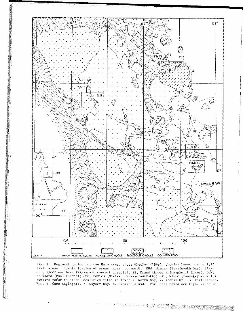
Fig. 1. Regional geology of the Nain area, after Wheeler (1968), showing locations of 1974field areas. Identification of areas, north to south: RWW, Wiener (Tessiuyakh Bay); JASJHB, Speer and Berg (Kiglapait contact aureole); SB, Brand (Lower Khingughutik River); DEW,de Waard (Paul Island); HMD, Davies (Niatak - Nukasorsuktokh); RAW, Wiebe (Tunungayualok I.).Numbers refer to other localities cited in text: 1. North Bay, ~Khaukh Hr., 3. Port ManversRun, 4. Cape Kiglapait, 5. Snyder Bay, 6. Okhakh Island. For other names see Figs. 24 to 26.
-1
THE NAIN ANORTHOSITE PROJECT. LABRADOR: FIELD REPORT 1974
INTRODUCTION AND REVIEW
The Tagesbuch of the Moravian Mission station at Nain contains
many entertaining or curious entries. Among them is that of a summer's
day in 1926 reporting the arrival of the young American E.P. Wheeler,
with the cryptic notation "He has come to study our rocks!" One of
the beauties of language is that an exclamation point can say so many
things. No doubt surprise and pleasure were included in the original
emotion, but in retrospect it seems appropriate to infer an element
of prophecy in that bit of punctuation. To Pep Wheeler, the rocks
deserved the exclamation point. They kept him busy and happy. Once
when thanked for a very fine field excursion, he said "I don't see
why; you people did all the work, and nobody can blame me for the
geology of Labrador", Readers of past reports in this series will
have seen the signs of his continued blameless activity. A new discov
ery by J.H. Berg in 1974 makes it appropriate to cite an example of
his valuable insight, and in so doing to comment on an intramural
debate which has rarely been publicized because of a scarcity of defin
itive information.
The anorthosite problem has many bizarre or puzzling facets,
several of which are discussed in this fourth field report of our
series. One of these is the not uncommon occurrence ~fgxanular mafic
or basic rocks near anorthosite in the contact zones. Such rocks are
particularly well developed between the Kiglapait intrusion and the
Snyder Group, where they have been called the Outer Border Zone (OEZ)
of the Kiglapait intrusion (Morse. 1961, 1969).
The OEZ was originally classed by Wheeler (e.g. 1968) as "granu
lite of uncertain origin", This was an apt name. The uncertainty
was more or less disavowed by Morse in 1961, and again, somewhat less
strongly, in 1969. For fifteen years no ot~er single topic occupied
more of their discussions and correspondence. Morse found it a
2
reasonable conclusion that this was a variety of chilled margin of
the Kiglapait intrusion, contaminated by water from the adjacent
Snyder Group to give brown hornblende in equilibrium with plagioclase,
olivine, augite, titanomagnetite, and locally, hypersthene. This
conclusion appeared to be strengthened by a systematic mineralogical
study of his specimens performed by Berg (1971). Metasedimentary
material, which bothered Wheeler, was ascribed by Morse to slivers
of country rock in a Zit-par-Zit injection, or to xenoliths. Wheeler,
inclined toward a metamorphic origin, was even more bothered by the
granular texture and lineation. In a 1966 postcard, he reported
that he had discovered a memorandum to himself which ran: "I am
impressed by the shifts to which Morse must resort in explaining
this rock ... " Still further shifts are required. Berg has now had
several opportunities to visit the OBZ for himself, and in this
volume he reports that a large part of the original map unit consists
of metasedimentary rocks belonging to an entirely new sequence over
lying the Snyder Group. Among these are an oxide iron formation and
a sequence of cordierite-bearing granulites. At the top of this
sequence, he reports a thin olivine gabbro porphyry which he inter
prets as the true chilled margin of the Kiglapait intrusion. The
metasedimentary units are interlayered with abundant, more resistant
basic granulites; these are the lithologies originally mapped and
sampled as OBZ. The basic granulites can no longer be imagined as
a contaminated chilled margin of the intrusion unles~_it be supposed
that the new metasedimentary sequence is largely xenolithic, and this
seems unlikely because of its persistence along strike and because of
the presence of a better, thinner candidate for a chilled margin.
The basic granulites must therefore either be metabasalts belonging
to the new stratigraphic sequence, or conceivably sill~which preceded
the emplacement of t he main body of magma. This latter notion, which
should by no means be identified with Mr. Berg, stems from the pro
blems of mineralogy, texture, and mafic basaltic bulk composition which
seem awkward to explain under a hypothesis involving metamorphosed
extrusive or hypabyssal basalts. In short, while doubts remain, the
entire problem takes on a decidedly different cast with the identifi-
cation of the new stratigraphic sequence.
By such random walks do we proceed toward the truth.
=

I
3
Among other bizarre facets of the Nain complex is the discovery
by Wiebe, reported herein, of adamellite containing diorite inclusions
which show strong evidence of having been liquid at the time they were
incorporated into adamellite. In fact they are chilled against adamel
lite, and they show convex protrusions typical of basic magma mixed
with acid magma elsewhere in the world. The diorite inclusions plus
adamellite matrix define a hybrid rock unit in which the ratio of the
two members varies widely, but in which the adamellite is the carrier
member. Visitors to the area were impressed with the strength of the
evidence for mixing of magmas; this needs to be stressed, because
Professor Wiebe is acutely embarrassed at having found such evidence,
now for the third time, in every major field area he has investigated
(California, Nova Scotia, and Labrador). If it is a pathological
manifestation, it is a remarkably contagious one, as any visitor will
discover for himself.
The ancient Archaean rocks which occur in the surroundings of
the Nain complex have long been one of the targets of our research,
because of a conviction that the origin of the complex must be judged
in the context of the entire history of crustal evolution in this area.
Last year we reported the discovery of Archaean anorthos:i,te similar to
that of certain noted Greenland occurrences. The occurrence at Okhakh
Harbour offered little in the way of stratigraphic or structural
information, but it seemed reasonable to infer from the presence of
an altered ultramafic cumulate that the calcic anorthosite might be
part of a differentiated basic sill. Wiener has now ~xamlned a far
more extensive occurrence at Tessiuyakh Bay which has the distinctive
signature of tiger-striped gneiss (foliated hornblende anorthosite)
found at Okhakh Harbour. This turns out to be an undoubted example of
a basic sill which varies repetitively from an ultramafic basal unit
through hornblende melagabbro and gabbro to anorthosite. Rhythmic and
graded layering, magmatic erosional features, and the vestiges of large
plagioclase phenocrysts all testify to the origin of the unit, and
allow the rudiments of a regional structural interpretation to be made.
The structural integrity of the unit is preserved despite wholesale
engulfment in granite, so that the remnants of the basic sill are
entirely xenolithic. This is a feature held in common with Greenland
examples. Genetically, such anorthosite-bearing sills may have more
4
in common with the highlands of the Moon than with massif anorthosite,
and yet it is tempting to ask whether they, too, represent an unusual
and perhaps temporally restricted event in earth history. The pro
blems of dating these rocks have been severe, and yet we can at least
say that the major ones which are older than 2.6 Gyr and which appear
to have much in common probably include Sittampundi, Limpopo, Fiske
naesset, Okhakh-Tessiuyakh and the Stillwater complex of Montana.
Possibly Bushveld should also be included. There is food for thought,
and grist for the isotopic mill,
The P-T conditions in the contact aureole of the Nain complex
have much to say about the emplacement depth and history of that com
plex. Last year, Berg was able to define closely, in terms of existing
experimental data, the pressure of metamorphism in one part of the
contact aureole, He has extended this work, chiefly by means of cor
dierite-garnet equilibria (and through the courtesy of several collab
orators who provided specimens) to a far wider geographic distribution
which sparsely encompasses the entire aureole of the complex. The
data show a remarkable and so far systematic pattern of higher pressures
(near 6 kbar) in the central latitudes of the aureole, decreasing to
lower pressures (less than 4 kbar) toward the north andcsouth. Other
geobarometers agree remarkably well. Berg stresses the point that
whereas the absolute calibration of the barometers may require revision,
the relative differences must be meaningful, and this leads to inter
esting problems of interpretation. Again, the results clearly point
to moderate rather than great depths of emplacement·.·~and the profound
depths once ascribed to all massif anorthosite can now be relegated to
the status of myth.
These conclusions are supported in detail by the work of Speer,
who discusses the metamorphism of the Snyder Group and other rocks
in the contact aureole of the Kig1apait intrusion. He recognizes four
mineral zones defined by the reactions leading to the appearance of
cordierite and sillimanite, and to the disappearance of anda1usite.
The latter reaction overlaps to some extent the familiar second silli
manite reaction, which is not mapped as an isograd here because of
the apparently variable behavior of water. The presence of iron form
ation and calc-silicate rocks afford still further possibilities for
5
evaluating the roles of volatiles, temperature, and pressure in the
Kiglapait contact aureole.
Speer defines a new lithologic unit, the Kiglapait Coast Migma
tite, which shows evidence of partial melting due to the presence
of the Kiglapait intrusion. The rheomorphic part of this unit was
previously known as the granodioritic matrix of an agmatite in Wendy
Bay; what Speer has done is to. trace this melt fraction away from
the Kiglapait contact through a transition zone and back to the primi
tive lithologies of the Tikkegharsuk migmatites.
The melt he describes is therefore a rejuvenated low-temperature
fraction of these migmatites, occurring after a presumed interval of
at least 1 Gyr. Recognition of this unit, and confirmation of an
eastern segment of Snyder Group lithology near Perry's Gulch, should
provide keys to a satisfactory characterization of the rocks in the
contact aureole, which were only hastily mapped by previous workers.
Within the anorthosite complex, Davies has found a substantial
area of calcic anorthosite brecciated by noritic material on Uighordlekh
Island. This refractory material closely resembles the pure anorthosite
which occurs as xenoliths in "block structure", and the large occurrence
may in effect be the autochthonous source rock of such xepoliths. Using
this relationship as a starting point, Davies has worked out the
probable age relations of five rock types of the anorthosite kindred,
based mainly on the lithology and abundance of their foreign inclusions.
It is hoped that correlation by these methods may eventually be extended
to contiguous or similar areas, which will be an impor"tant" first step
in understanding the wave after wave of successive intrusive events
which appear to characterize the Nain complex.
Working on a nearby part of Paul Island, de Waard and Hancock report
a different manifestation of the phenomenon of multiple'anorthositic
intrusion, in this case one which could easily have been overlooked and
which may be much more common than hitherto recognized. This example
consists of a large irregular dike of anorthosite emplaced in anortho
site. The separate identity of the two units is fortunately revealed
by the presence of olivine in the younger one.
6
Brand has continued to unscramble a plethora of intrusive rock
types in a small area of the western contact zone. Among these are
three types of anorthositic rocks, three dioritic rocks, and a pyrox
ene granite. A dark monzodiorite is now found to be mappable, and
a remarkably tabular xenolithic slab of 1euconorite occurs well
within its host granite body. Field relations in this complex area
are now sufficiently well established for the laboratory study to be
very rewarding.
The progress of laboratory research is now such that many
interesting results of this Project are appearing in print or in
theses. Abstracts of such papers appear in a separate section of
this report, along with a bibliography. Of particular interest
will be the substantial geochemical contributions of Barton on the
Mugford Group, Snyder Group, and basic dikes of the Nain region. Two
articles which spring from 1974 work and which would have received
extended treatment in this report if not for their expected early
appearance elsewhere are those of Berg and Wheeler on osumi1ite and
of Morse on plagioclase lamellae in hypersthene. The former is the
first report known to us of osumi1ite in a deep-seated environment,
and it is especially important because it may help to cexp1ain why
experimental studies to date have failed to show a stable field of
existence for this mineral; at the same time it suggests important
evidence for the scarcity of water in rocks of the Nain contact
aureole. The latter article demonstrates that the plagioclase
lamellae in hypersthene cited in last year's field'report by Morse and
Wheeler are in fact exso1ution products from a former pyroxene with
appreciable amounts of jadeite and Ca-Tschermak's molecule. The
article draws almost solely on work performed aboard R/V Pitsiulak,
and is buttressed and extended by a valuable paper in preparation by
R.F. Emslie of the Geological Survey of Canada, who cites similar
occurrences elsewhere in North America and in Norway. The origin of
such lamellar intergrowths is presumed to be related to decompression,
although from what depths and by what means remains unclear.
-- S.A. Morse

7
REGIONAL GEOLOGY
An Archaean Gabbro - Anorthosite Complex~ Tessiuyakh Bay
Richard W. Wiener
University of Massachusetts l
Introduction
Archaean anorthosite and associated hornblende gabbros (e.g. Iftiger
striped gneiss lf) were collected from the east shore of Okhakh Harbour,.
Labrador, in 1972 and mapped in more detail in 1973 (Hurst et al., FR 1973,
p.9). The Okhakh locality was revisited in 1974, and then on the basis
of Wheeler's Iftiger-striped gneiss" localities (Fig. 4, p. 14, FR 1973),
the Tessiuyakh Bay region was examined with the hope of finding more
Archaean anorthosite and discerning its field relations. This report
outlines the discovery of a layered, metamorphosed and deformed sill
composed of anorthositic to hornblende ultramafic rocks hereafter named
the Tessiuyakh Gabbro Complex. The complex occurs among migmatitic
country rocks and is everywhere cut by abundant granite. I,t bears a
strong resemblance to Greenland occurrences of Archaean hornblende
gabbro-anorthosite described by Windley (1969).
Rock Units and Petrography
Country Rocks. The country rock into which the Tessiuyakh Gabbro
was emplaced is a migmatitic gneiss. It crops out extensively (see Fig. 2)
on Tikkegharsuk Peninsula, inland around Nakharvik Brook and at places
within the Tessiuyakh Gabbro Complex. It is a pink to green weathering,
white to gray, medium-grained, quartzo-feldspathic gneiss. The leuco
cratic layers contain quartz, plagioclase (An 20-40)' microcline, olive
brown to green hornblende and red-brown biotite, with lesser amounts of
epidote, magnetite and apatite. The melanocratic layers contain quartz,
plagioclase (An 30-40)' green hornblende and brown biotite, with lesser
amounts of epidote, magnetite and pyrite.
lAuthors' full addresses are given at the back of this volume.

8
I
/
85
/
/I
I
Fold Axis
Foliation
\\ 1\ '
~'~J)f50 \ 'I , \87
I II \\ II \\ I I II )1 I
/ 1/ I
I1/ I
II I
Ifs5!1 /
ko/ rih5
jI 1/
/ /// //
I //I II
~41
Overturned Isoclinal Anticline c==:
c:: + MIG
11I II II I
/ I/ /I II I
I I...../ I
/;:0-/___II' ~o~.~-_ ...
---,.",
TESSIUYAKH BAY
II
I I1/ /
I .//
I 'I' (/'A II I" ~ // It' / /' ......... 40~ / /1 I I__~.... 4?\ / // / ~ I::=== _~:::: ......, 5~ /// / vI-- ~......... / / / ........-- :::"::.::::~ ~....... // / /
AnorthositJ.C 30 "",>--....__~~.:;: _ ~::::d ,/' /e Gneiss .--... ">.... .....~ -=..-:_ _.7 / /
......... , ~~o --b-- '-~
d Leucogabbro ~ ,._' ----- ./ ,,"'''Gneiss - ---- -............. b.,.,,_"'''''--Gabbro -----
c Gneissb Melagabbro
Gneissa Ultramafic
AgmatiticAG Gneiss
Well-LayeredWL Gneiss
lkmo
MigmatiticAgmatitic orWell-LayeredGneiss
3..... ---/
/./
/
57°14'~-- - ---
MIG
TessiuyakhTGC Gabbro
Complex
')L-- ....l- -L.-L:..---~"---.L--------------J.--
Fig. 2. Geologic sketch map of the outer Tessiuyakh Bay area.
I
7
9
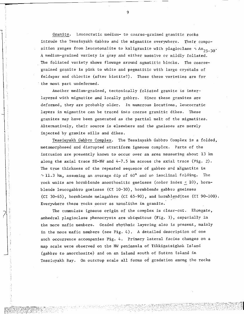
Granite. Leucocratic medium- to coarse-grained granitic rocks
intrude the Tessiuyakh Gabbro and the migmatite everywhere. Their compo
sition ranges from leucotonalite to kaligranite with plagioclase ~ An25
_30
.
A medium-grained variety is gray and either massive or mildly foliated.
The foliated variety shows flowage around agmatitic blocks. The c9arse
grained granite is pink to white and pegmatitic with large crystals of
feldspar and chlorite (after biotite?). These three varieties are for
the most part undeformed.
Another medium-grained, tectonically foliated granite is inter
layered with migmatite and locally gabbro. Since these granites are
deformed, they are probably older. In numerous locations, leucocratic
layers in migmatite can be traced into coarse granitic dikes. These
granites may have been generated as the partial melt of the migmatites.
Alternatively, their source is elsewhere and the gneisses are merely
injected by granite sills and dikes.
Tessiuyakh Gabbro Complex. The Tessiuyakh Gabbro Complex is a folded,
metamorphosed and disrupted stratiform igneous complex. Parts of the
intrusion are presently known to occur over an area measuring about 13 km
along the axial trace SE-NW and 4-7.5 km across the axial trace (Fig. 2).
The true thickness of the repeated sequence of gabbro and mlgmatite is
~ 11.3 km~ assuming an average dip of 60° and no isoclinal folding.. The
rock units are hornblende anorthositic gneisses (color index ~ 10), horn
blende leucogabbro gneisses (CI 10-30), hornblende gabbro gneisses
(CI 30-65), hornblende melagabbro (CI 65-90), and hornblendites (CI90-100).
Everywhere these rocks occur as xenoliths in granite.
The cummulate igneous origin of the complex is clear-cut. Elongate,
anhedral plagioclase phenocrysts are ubiquitous (Fig. 3), especially in
the more mafic members. Graded rhythmic layering also is present, mainly
in the more mafic members (see Fig. 4). A detailed description of one
such occurrence accompanies Fig. 4. Primary lateral facies changes on a
map scale were observed on the NW peninsula of Tikkigatsighak Island
(gabbro to anorthosite) and on an island south of Sutton Island in
Tessiuyakh Bay. On outcrop scale all forms of gradation among the rocks

10
of the complex may occur. (By contrast, in Okhakh Harbour, two genera
tions of anorthosite were observed: a massive coarse-grained blue-gray
anorthosite is cut by tiger-striped anorthosite. Multiple intrusive
relations are seen on the west shore of Okhakh Harbour where tiger
striped anorthosite foliation is cut sharply by hornblendite, and tiger
striped anorthosite in turn invades the ultramafic rocks with apophyses
of plagioclase-rich material.) At Tessiuyakh, the relationship between
hornblendite and anorthosite is commonly transitional through gabbros
on outcrop scale (graded layering). This relationship is locally in
the nature of a pencil-thin contact. The anorthositic to hornblende
leucogabbroic gneisses are poorly to well-layered, medium- to coarse
grained plagioclase-hornblende-epidote gneisses, with accessory biotite
and chlorite. The gneisses are characterized by folia or double- .
tapering streaks of coarse green hornblende (with minor epidote) and
grey to white medium-grained granular plagioclase, which give the gneisses
the (Siberian) tiger-striped effect noted first by Wheeler.
The hornblende gabbro gneisses and granulites contain minor ortho
pyroxene and pyrite in addition to the anorthositic mineralogy. These
rocks are the most common bearers of plagioclase phenocrysts.
The hornblende melagabbro gneisses and hornblendites are greenish
black, massive, medium- to coarse-grained rocks. Hornblendites and
hornblende melagabbros are associated together as are the anorthosites
and leucogabbros. Gradations into gabbro (rarely anorthosite) are
present. One petrographic analysis shows a pred~mi~ancg of green to
brown-green hornblende with zoned plagioclase (average An4l ) and minor
orthopyroxene, biotite and magnetite. Minor bodies of gray-green serpen
tinized olivine(?)-pyroxene granulite and green actinolite-chlorite rocks
are associated with some of the hornblendites. The actin9lite and
chlorite zones appear as cores in hornblendite blocks in the migmatite.
Diabase. Post-metamorphic diabase occurs in dikes crosscutting all
earlier rock structures. In many places the diabase (as in the Koghukulluk
Bay region) occupies faults and shear zones which clearly show on airphotos

Fig. 3.
Zoned plagioclasephenocrysts in ahornblende-richmatrix
10cm
Fig. 4.
Graded layering ingabbro with imbricateplagioclase phenocrysts
C.I.=50
C. I ..==60~Fine grained
C.I.=60 Matrix C.I.=80
C.I.=80 Medium grained
C.I.=40
C.I.=20
C.I.=65
C.I.=80C.I.=35C.I. ...SC.I.=35
C.l.=60 Medium grained withintercumulus plagioclaseC.I.=85
10cm
.J
"~,~." ,.'(j- ~~ .. ,. . 'Q" ". c-'\ .' '. ~ . '. . . . '. '.~ .' .."....... '-../: ,", .C .. <;;:5;. ~. _.' .' .'~""'" •. 1.-..1 ••.••. '.'
• (""-0,,' '~••~.• do. . . '. c::J~ '" " . '. . .;).,,. . ~,' ... ...,. .. " ..."O~ '.~ '. : ,' ..
' tlo'" <::)" D. , . . .~ .~ .......~, '~6'~' : ~.~ .. :~: :'.' ~ :: ... ' ~ o' ' '.,.~ . . ... f0 .'J. . . .. . D.. c:::. ...:.:: .
_~.:~C;i,i.JJ!J;jf~:;;~.~(;::,.;;:tIG,·j~i:dll.. ,' . ~<:;;;. , ."" . ',,~ ~ ~../\ .'"" ~£,c::., «3 "\..) ~ ~ a ..~",. <:>" '0:::::, .....~
.....:',.&......,.~
·~~~'t!2~o

12
and the ground as pronounced linears. The diabase is often sheared
against the walls of the dike. The country rock shows quartz and chlorite
mineralization, slickensides, and granulation along the shear walls.
Structural Relations
The structure of the Tessiuyakh Gabbro is an antiform plunging
160-165° at 35° (see Fig. 2); this, with one exception, is the general
trend and plunge of minor fold axes. The axial plane strikes approxi
mately 312° and dips SWat about 50°. The axial trace is indicated on
Fig. 2.
The contacts are alternately sharp and gradational; this is true.on
outcrop scale as well as map scale. At the mouth of Nakharvik Brook,
two distinct anorthosite layers are traceable around parts of the fold;
they are exposed on both limbs and the NW unit is well foliated in
contrast with the SE unit. On the east shore of Avakutakh Bay the
stratigraphic succession indicates igneous tops to the east (right side
up). To the northwest, the sequence is upside down (tops to N in
southerly dipping units). If this method of topping is r~liable here,
the presence of an earlier isoclinal structure is a strong possibility;
an earlier axial trace would be crossed from SE to NW passing from the
upper limb to the lower inverted limb of the earlier structure (see Fig. 2).
Minor fold evidence (refolded folds) support this pos~ibility. The hinge of
the early fold would lie to the W or N along strike. No obvious
repetition of the stratigraphy across the possible axial trace has yet
been deciphered.\
The contacts with the migmatite are conformable, or possibly they
are fault contacts. The Tessiuyakh Gabbro may have been intruded as a
Stillwater-type sill. The contact is also transitional in that frag
ments of the Tessiuyakh Gabbro are found in migmatite terrain either
as sills of snipped-off ultramafic boudins (locally folded) or as
angular fragments in the partial melt of the migmatite. The migmatite
is also present as layers within the Tessiuyakh Gabbro. This probably

13
reflects either multiple injection of sills or piecemeal fragmentation
of the Tessiuyakh Gabbro by the partial melt of the migmatite.
The Tessiuyakh Gabbro has been strongly deformed so that a gneissic
foliation of alternating hornblende and plagioclase-rich layers developed
parallel to primary layering. The foliation is accentuated where granite
has been injected, recrystallized and flattened parallel to the gabbro
gneiss foliation. Where granite is undeformed, local rotations of the
Tessiuyakh Gabbro have occurred. This feature is also prevalent at
Okhakh Harbour and at Wheeler's occurrence #3 (FR 1973, p. 14). In
places the gabbro (especially the melagabbro) is massive; there are
gradations from well-layered to massive gabbro. Plagioclase pheno
crysts have been stretched and flattened. In places the phenocrysts
define a prominent second foliation at an oblique angle to the layering;
this structure must be either a record of magmatic currents or a
secondary deformational feature (see Fig. 4). Individual grains are for
the most part granular. Some of the gabbros are cataclasites.
The ultramafic rocks rarely show the sheared or flattened textures
of the more leucocratic (anorthositic) members of the Tessiuyakh Gabbro.
The high mafic content evidently accounts for the different"fabric
development during deformation. Sheared anorthosite is commonly formed
in close proximity to massive melagabbro. The ultramafics also behaved
competently with respect to the migmatites and granites; squared-off
boudins of hornblendite indicate a very high ductility contrast.
The internal structure of the migmatite varies from agmatitic
gneisses with angular mafic inclusions (often the Tessiuyakh Gabbro)
through ptygmatic migmatites characteristic of Tikkergharsuk Peninsula
to well-layered, recrystallized, and flattened gneisses. The three
textures are seen to grade into one another and may constitute local
deformational gradients. Both ptygmatic and agmatitic textures have
granitic portions which are undeformed.

14
Age Relations
The Archaean age of the anorthosites has been well documented
(FR 1973~ pp. 12-16). The Okhakh Granite (2.4 Gyr) cuts the anorthosite
and is~ therefore~ younger. The same relationship is observed in
Tessiuyakh Bay. Zircon from Okahkh anorthosite yields an age ~ 2.6 Gyr
(FR 1973~ p. 15).
A K-Ar age on hornblende from a migmatiteinTessiuyakh Bay
yielded 2.566 Gyr ± 0.014 (Barton and Barton~ in press). This date may
represent uplift immediately following the final stages of metamorphism
and migmitization.
The sequence of events involves deposition of the original migmatites
(acid and basic volcanics?) and intrusion of the Tessiuyakh Gabbro. This
was followed by high grade metamorphism and migmitization (at least upper
amphibolite facies) accompanied by strong deformation around 2.5 Gyr.
Granitic rocks were generated or emplaced about this time~ some of which
saw further flattening and recrystallization~ others of which crystallized
in a post-tectonic setting. Retrogression~ shearing~ and emplacement of
diabase are the latest visible events.
Petrology
The green hornblende-plagioclase (~An75) assemblage may reflect
either emplacement as a wet magma with primary hornblende or hydration of
norite during metamorphism. Amphibolite facies conditions have affected
the surrounding country rocks and there is nothing to argue against these
conditions in the gabbros and anorthosites. Detailed petrography and
probe analyses may uncover original igneous trends in the plagioclase
and hornblendes~ as has been done in Greenland (Windley~ i97l) and South
Africa (Hor et aI, 1972).
Conclusions
Comparisons with other Archaean anorthositic complexes is instruc
tive. It has been suggested (Windley~ 1969) that Archaean anorthosites

15
were generated at two crustal levels, and that they represent Archaean
crustal sections. The deep level complexes are characterized by
granulite facies metamorphism, chromite layers, spinel peridotites,
anorthosites and phase and graded layering. The high level complexes
are homogeneous hornblende gabbro-anorthosites in areas of extensive
migmitization, with agmatitic textures, no layering, little ultramafics,
and phenocrysts of the plagioclase in the gabbro. They are brought to
the surface in the cores of antiforms. The Tessiuyakh gabbro is
identical to the high level complexes but for the presence of ultra
mafics in greater quantity and graded layering. Minor occurrences of
pyroxenites at Okhakh Harbour (FR 1973) and serpentinized pyroxene
granulites from Koghukulluk Bay, Nakharvik Brook, and Tessiuyakh Bay
(Morse, 1974, personal communication) may represent locales of the
deeper section. Primary lateral variations (Windley, 1969, p. 19)
are described from Greenland and observed in Tessiuyakh Bay (see above).
The pre-continental drift fit of the continents partly closes the
Davis Strait (Bullard, e~ al, 1965, p. 41) and brings the Atlantic Archaean
craton into a roughly triangular massif 600 km on a side (Bridgwater
et al, 1973). The sequence of events at Tessiuyakh Bay is
not unlike the relevant part of Bridgwater's sequence in Greenland
(Bridgwater ~ al, 1973, p. 496).
Future work should consider the possibility of a~ ~arlier isoclinal
structure to the N or W along strike. The borders of the intrusion to
the Nand W should be delimited, and detailed mineralogy and petrology
remains to be completed.

Fig. 5. Mineral changes in pelitic, basic, calcareous, and iron formation rocks of the Snyder Group with metamorphism.
III
FACIES
II
GRANULITE
Ib
AMPHIBOLITE FACIES
- - - -42-----1-49--- 85 -
16
I ..
FACIES
GREENSCHIST
'--- >10 --_1-------+-------1-- < 1 -
~-----_I------_I_------_I- .loI;n..l>bl- _
~----~---------~----~
~-----+---46 --+-------1--- 85 -
1-------1------+-------1-----
METAMORPHIC FACIES
MINERAL ZONES
quartz
K· feldspar
plagioclase (loAn)
andalusi te
fibrolite
sillimanite
chlorite
amphibole
~ epidote
= muscovi tew
"" biati te
cordierite
garne t (%MnO)
clinopyroxene
orthopyroxene
spinel
pyrite
pyrrhoti te
quartz
plagioclase(%An)
K feldspar
chlorite
epidote~w
biotitero~
='!clinopyroxene
orthopyroxene
amphibole
cumming toni te
titanite
calcite
olivine
w phlogopite
~
:E tremeli te
chlorite
spinel
quartz
diopside
w calcite
v;tremolite
ro phlogopi teu
K feldspar
plagioclase
quartz
garnet
~clinopyroxene
c orthopyroxene0
clinoamphibole
orthoamphibole

17
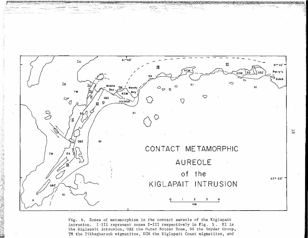
THE CONTACT METAMORPHIC AUREOLE OF THE KIGLAPAIT INTRUSION
J. A. Speer
Virginia Polytechnic Institute1
Introduction
Since the last report (Speer, FR 1973), the major research effort
involving the Snyder Group has been in regard to its metamorphism by the
Kiglapait intrusion. Observations have also been made on the intermedi
ate gneisses and Snyder Group in the contact aureole along the northern
coast of the Kiglapait Mountains eastward from Snyder Bay to Perry's
Gulch (Umiakoviktannak). This work doubles the length of the contact
aureole under consideration to most of its accessible ,length.
Progressive Mineral Changes
The progressive mineral changes in the Snyder Group are summarized
in Fig. 5. The contact aureole has been divided into four mineral zones,
la, Ib, II, III, in order of increasing metamorphic grade. The major
boundaries, Ib-II and II-III, have been chosen at the first appearance
of sillimanite and the last appearance of andalusite respectively. These
particular phases were chosen because they are easy to map in the Snyder
Group and because the reactions involving them are presumed to be inde
pendent of a fluid phase.
Zone I has been further divided by the dehydration reaction:
chlorite + muscovite + quartz ~ cordierite + biotite + A1 2Si05 + H20 (1)
which summarizes the reactions leading to the formation of cordierite,
marking the beginning of the amphibolite facies, and the disappearance
of chlorite with quartz or with quartz and muscovite, indicating the
end of the greenschist facies. The Ia-Ib boundary is drawn at the last
appearance of the assemblages chlorite + quartz or chlorite + muscovite
+ quartz. Because of probable variation in the relationships of bulk
rock chemistry and of fluid pressure relative to total pressure, the
dehydration reaction governing the appearanc~ of cordierite appears to
lAuthors' full addresses are given at the back of this volume.
°1
--------- -ill
..../
/'
61°40'Io
10 y'; f Y .... -- .... -ij
Cl O G0
KI
[/(0 \J
0
~
Q; ." if)!0KI
0°I
I-'
KI
I 00
CONTACT METAMORPHICT~ J /\SG Jl~ \
AUREOLE
of the
KI~KIGLAPAIT INTRUSION
57° 05'
0 I 2 3, 4,KM
Fig. 6. Zones of metamorphism in the contact aureole of the Kiglapaitintrusion. I-III represent zones I-III respectively in Fig. 5. KI isthe Kiglapait intrusion, OBZ the Outer Border Zone, SG the Snyder Group,TM the Tikkegharsuk migmatites, KCM the Kiglapait Coast migmatites, and
19
take place over a considerable range of temperatures, making location
of the associated isograd difficult.
A problem in terminology arises when we consider that the Snyder
Group metamorphic rocks clearly represent an aureole of contact meta
morphism, but that the mineral assemblages are equally representative
of a low-pressure regional metamorphic facies series. By choice of
mineralogic rather than genetic definitions of the metamorphic facies
the terminology used in Fig. 5 is proper. The common low-pressure
facies series of metamorphism, both regional and contact, is greenschist,
amphibolite, granulite. The Kiglapait intrusion can be considered to
have a contact metamorphic aureole containing andalusite at low grade
and sillimanite and orthopyroxene at high grade with a facies series
similar to that of a low-pressure regional metamorphism.
The following is a more detailed discussion of the progressive
mineral changes with increasing metamorphic grade for each rock type.
Metapelites. Chlorite is common in the pelites of zone la, but a
small amount of cordierite is everywhere present. This is taken to
include either differing P in adjacent beds or differing bulk rock-aq
chemistry. The uppermost boundary of zone la is drawn where chlorite
ceases to be evident in any beds and presumably represents the comple
tion of reaction 1. The quartzites and aluminous gneisses 'contain K
feldspar, although it is not clear whether the mineral is an abundant
detrital relic or a product of the dehydration reaction:
quartz + muscovite ~ andalusite + K feldspar + H20
which may have proceeded at very low temperatures under conditions of
~aq less than Rtotal' Single crystal X-ray photographs show the K
feldspar to be a cryptoperthite of albite- and pericline-twinned plagio-"
clase and a pseudo-monoclinic K feldspar. It is probable that these
phases unmixed from what was originally a homogeneous monoclinic phase.
The present K feldspar has microcline grid twinning indicating that it
is triclinic. The apparent monoclinic symmetry shown in X-ray photo
graphs is due to the very abundant fine-scale"twinning on the albiteand pericline twin laws. Muscovite is commonly greenish, suggesting a
phengitic composition. A rather spessartine-rich garnet (16 wt. % MnO)
(2)

20
occurs in. zone Ia. In coarse cross-bedded quartzites, epidote and a
blue-green amphibole occur.
Zone II is defined by the appearance of sillimanite in the pres
ence of andalusite. Owing to numerous examples of andalusite-silli
manite intergrowths and the rather simple mineralogy of these rocks,
sillimanite is regarded largely as having formed from the transformation
of andalusite. The rather large (0.75 km) width of this zone is due
either to the sluggish nature of this transformation or to an over
printing of a continuum of thermodynamic conditions. An andesine
plagioclase regularly appears in this zone.
The highest temperature zone, zone III, is mark2d by the complete
disappearance of andalusite in the pelites. It also coincides closely
with the beginning of the granulite facies, shown by clinopyroxene and
orthopyroxene in metabasites and orthopyroxene, almandine garnet, and
cordierite in metapelites. "The reaction
muscovite + quartz ~ sillimanite + K feldspar + H20
which is the second sillimanite isograd, appears complete in the begin-
ning of this zone in rocks of greatest P The dehydration of muscovite-aq
at lower grades has proceeded at lower values of Paq . Biotite still
remains, although its coexistence with quartz, K feldspar, and ortho
pyroxene indicates that the reaction
biotite + quartz~ orthopyroxene + K feldspar + H20
is taking p lace in this zone. Plagioclase compositions are in the range
labradorite to bytownite. The orthopyroxene is quite iron-rich (Fs67)
and locally is exsolved. Rarely the exsolved pyroxene is in itself
exsolved to two pyroxenes. Amphibole is present and appears to be a-,
retrograde product of a reaction involving pyroxene. Optically, much of
the K feldspar is orthoclase, although X-ray examination shows it to be
similar to zone Ia K feldspar.
Metabasites. In the lowest temperature zone, la, the metabasites
show relict textures but their mineralogic recrystallization is virtually
complete. It appears that the Snyder breccias were porphyritic with
phenocrysts of plagioclase that have since been recrystallized to oligo-
(3)
(4)

21
clase + magnetite + calcite + quartz. The mafic portion of the metaba
sites has recrystallized to an assemblage of biotite + ferrohornblende
(Leake, 1968) and subordinate chlorite + epidote.
With a further rise in temperature in zone Ib, chlorite disappears
and is replaced by clinopyroxene. The associated plagioclase is andesine.
Increasing metamorphism then begins to form abundant cummingtonite in
zone II as the small amounts of epidote disappear. In the highest temper
ature zone, II, the cummingtonite disappears and an orthopyroxene
clinopyroxene-brown hornblende-bytownite-quartz assemblage with minor
biotite dominates. Almandine garnet does not occur in the Snyder breccias;
however, manganiferous garnets are present in some quartz-rich dikes.
The cummingtonite contains exsolution lamellae of hornblende and the
brown hornblende contains exsolution lamellae of cummingtonite. The
clinopyroxene is exsolved to two pyroxenes.
Iron Formation, Marbles, and Calc-silicates. The progressive
mineral changes of the iron formation are little understood at the moment
and may only reflect changes in the bulk rock chemistry. The pyroxene
present in zone I. a manganoan hedenbergite, is replaced in zones II and
III by an orthopyroxene. Grunerite disappears after zone II, perhaps
replaced by a ferroanthophyllite in zone III. The garnet remains
manganese-rich throughout, becoming more grossular-poor, pyrope-rich
with increasing metamorphic grade.
The details of the progressive metamorphism of the marbles and
calc-silicates are obscured by sampling problems and more importantly
by the apparent wide ranges in fluid pressure or flu~d .composition. This
is shown by dehydration and decarbonization reactions taking place over
a considerable range of temperature. However, by zone III, chlorite has
disappeared in the marbles, and calcite, tremolite, and phlogopite have
disappeared from the calc-silicates. At present, wollastonite has been
found only in veins on Snyder Island. Its presence in these veins is
thought to indicate very water~rich fluids moving through cracks, allow
ing the reaction of calcite and quartz to form wollastonite to proceed
at relatively low temperatures. Preliminary work on the high-grade calc
silicates from the north coast of the Kiglapait Mountains shows the
assemblage enstatite + diopside + quartz + phlogopite ± calcite. This
assemblage in zone III is equivalent to a tremolite-bearing assemblage
at lower temperatures or higher water pressures.
22
Partial Melting in the Contact Aureole
The Snyder Group affords little volume of material of appropriate
composition for partial melting. In contrast, the Tikkegharsuk migma
tites contain large volumes of such material as evidenced by anatexis
during one or more pre-Snyder Group metamorphisms. Textural and miner
alogic evidence from Hill 900 between Middle and Wendy Bays suggest that
the Tikkegharsuk migmatites have undergone another anatexis as the result
of the intrusion of the Kiglapait to produce the Kiglapait Coast migma
tites. These were mapped as intermediate gneisses by Morse (1969) and
were similarly concluded to be of rheomorphic origin. They crop out
from Wendy Bay almost to Perry's Gulch. Only Hill 900 has sufficient
outcrop perpendicular to metamorphic grade to observe the transition
between the Tikkegharsuk migmatites and the Kiglapait Coast migmatites.
Two features lend sharp contrast to the distinction between the
Tikkegharsuk migmatites and the Kiglapait Coast migmatites: deformation
and mineralogy. A traverse toward the Kiglapait intrusion shows the
following stages:
lao Tikkegharsuk migmatites: typically white and pink, highly
contorted and plastically deformed migmatites, having
undergone deformation and anatexis during an Archean re
gional dynamo-thermal metamorphism. Theycare biotite-
and amphibole-bearing, suggesting amphibolite facies meta
morphism.
lb. Tikkegharsuk migmatites: typical except that the rocks
are tan and contain orthopyroxene. These are evidently
effects of the contact metamorphis~ of~theKiglapait intru
sion. The granulite facies boundary corresponding closely to
the II-III boundary is drawn at the boundary 'between these
rocks and the typical Tikkegharsuk migmatites.
2. Kiglapait Coast migmatites: migmatitic struct~res, such as
stromatic (layered) and folded structures, schlieren
structure, schollen (raft) structure, and igneous breccias
are spectacularly exhibited by these rocks. On the whole,
the Kiglapait Coast migmatites are. not highly contorted.
Their foliation is strong and regular and appear conformable
to the border of the Kiglapait intrusion. The rocks,
according to modal analyses by Morse (1969) and work by
-23
Wheeler (pers. cornrn.). are hypersthene granodiorites
and tonalites (Johannsen numbers 227 and 228). According
to de Waard (FR 1972), these would be opdalitic and
enderbitic granulites. The melanocratic rocks are
mixtures of orthopyroxene, cordierite, biotite, and
some felsic minerals.
While the migmatite structures of the north coast are diverse
and generally intermingled. they appear to be mappable and could be
presented as a distribution of various rock/melt ratios either as a
function of initial composition or the amount of melt due to increased
temperatures. For example, agmatites constitute only a small percen
tage of the volume of the migmatites present and are developed only near
the contact of the Kiglapait intrusion. This is no doubt due to rock
compositions capable of producing large amounts of melt doing so only
near the hotter contact.
Embedded within the Kiglapait Coast migmatites are rocks which
appear to be originally ultrabasic rocks, basic rocks, calc-silicate
rocks, and quartzites. One group of such rocks lies on the point just
east of Wendy Bay and contains fragments of Snyder Group (quartzites.
iron formation, marble, calc-silicate rocks, and graphitic sulfide
bearing hornfels). Another, larger area of such rocks, ju~t west of
Perry's Gulch, consists of massive quartzites and a few marble beds.
Equivalence of these rocks with the Snyder Group is more problematical
and is tentatively concluded but not strenuously maintained until a
further study can be made of the area. This area mapped as underlain by
possible Snyder Group (Fig. 6) lies just east of th~ afea mapped as
possible Snyder Group by Morse (1969).
Determination of the Conditions of Metamorphism
After characterization of a metamorphic facies series it is use
ful to inquire into the absolute values of the parameters of metamor
phism. By making simplifying assumptions that fluid pressure = water
pressure = total pressure and that all phases have ideal end member
compositions, a petrogenetic grid (Fig. 7) can be constructed for the
metamorphic rocks of the Kiglapait contact aureole.
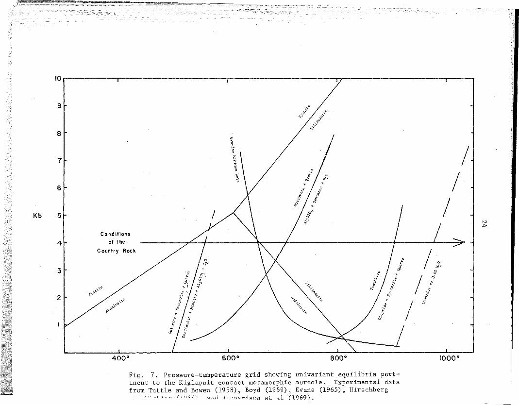
10. i I iJ • •
N.p-.
/I
/
1000 08000
'""~...."'"
600 0
Fig. 7. Pressure-temperature grid showing univariant equilibria pertinent to the Kig1apait contact metamorphic aureole. Experimental datafrom Tuttle and Bowen (1958), Boyd (1959), Evans (1965), Hirschberg
, T7~ __ 1_1 ~- /1 OhQ\ ~n;J 1<-i ,-h",rc1Ron et a1 (1969).
400 0
9
6
8
Kb 5
ICo nd itions
of the
Country Rock /' I \ "\. / J I .~:J""e5! '"<
"f- '"/Y Ii~~~/ 'j.' / \<.; ji~,,<> :J ,- -+- "'"->'>..
21- ";! t J! ':>,. q;'\;e- o . ..., '1,:, ~.. "f- J.
<;-,. " '" '" /...,
1>">'" " 0 <'v ~...,
" .c-f:>: a, "',. ...,~ ~- !1.
0
~

25
Two restrictions on the possible pressures of metamorphism can be
derived using this grid and the following observations from the rocks:
1) the A12Si05 polymorph transition is andalusite to sillimanite.
The best estimate of the aluminum silicate triple point (M.e.
Gilbert, pers. comm.) is 601° e and 5.1 kbar, which gives an
upper pressure limit.
2) the assemblage muscovite + sillimanite + quartz + K feldspar
is stable in part of the area. Evans' (1965) experimental
determination of the stability of muscovite in the presence
of quartz crosses the Richardson et al (1969) experimentally
determined andalusite-sillimanite transition at about 3.5 kbar,
which is a lower pressure limit.
This yields a possible pressure range of from 3.5 to 5.1 kbars. As the
first and second sillimanite isograds lie close together (0.15 km) in
the contact aureole, it is suggested that the lower end of this interval
represents the pressure during metamorphism. At the present erosional
surface, the pressure and temperature gradients reached during the Snyder
Group metamorphism are essentially orthogonal so that the line represen
ting increasing metamorphic grade is a horizontal isobaric line on the
R-.'!. grid.
Determination of temperature limits in the contact aureole is a
little more difficult. The Snyder breccia and undeformed basic dikes on
Tikkegharsuk Peninsula have mineral assemblages similar to those of
zone Ia. These rocks are too distant (up to 6 km) to be considered part
of the Kiglapait contact aureole; therefore, at the time of the
emplacement of the Elsonian plutons, the country rocks were probably
undergoing a regional thermal metamorphism in the low-pressure green
schist facies. The lower temperature limit of the greenschist facies is
usually taken to be between 300° and 400°C if Pfl 'd = P 1 (Winkler,- Ul -1;ota
1967).
The upper temperature limit is again difficult to specify because
of the relationships between Pf1
'd and P t l' However, if the pressure-" Ul -to a
is correct, the andalusite-sillimanite transition puts the temperature
at the sillimanite isograd equal to about 680 + 40 0 e. An assemblage of
hypersthene + K feldspar + quartz + biotite in a very biotite-rich rock
at Middle Bay indicates a limit of more than 700 0 e in zone III (Hess,
1969). "The assemblage enstatite + diopside + quartz instead of tremo-
lite suggests temperatures upwards of 900°C if Pfl 'd = P 1 (Boyd,- Ul -tota

26
1959). Tuttle and Bowen (1958) show that dry granites or charnockites
(water content less than 0.5%) melt over a large temperature interval of
6500 to 1000°C at 4 kbar. To produce nearly complete melts, as evidenced
by the nebulitic and agmatitic textures of the Kiglapait Coast migmatites,
the upper temperature limits of this range must have been reached. An
upper temperature limit can also be estimated by consideration of heat
conduction theory. For contact metamorphism according to Jaeger (1967),
an equation of interest is for a semi-infinite solid in the transient
state with unidirectional heat flow. One result is that if we assume
the instantanous emplacement of a magma at temperature Ie into a country
rock at temperature 1c, then the temperature after emplacement is ini
tially at the value ~ Ie + 1£ and will gradually decline. Thus for
basaltic magma with a liquidus temperature of 1200°C and Tc between 300°
and 4000C, the maximum metamorphic temperature would be 900° to 1000°C.
A convecting gabbroic magma could sustain such temperatures for some
period of time. 2
From the above arguments, the contact metamorphic aureole repre-
sents a metamorphism at a pressure of 4 ± 1 kbar with temperatures
ranging from 300° to 400°C in the country rocks to perhaps 900° or
more at the intrusion contact. This in excellent agreement with Berg's
(FR 1973, p. 36) ~-~ estimates in the contact aureo1~ of the Hettasch
intrusion. To make the experimental reactions comply directly with
the rocks in question, critical evaluation would have to be made of
bulk rock or mineral chemistry, relationships of -Pflu1"d' P and-water'
Rtotal' and other factors such as surface effects.
2The approximate fbrmula cited here requires. that !c « Ie, which israther far from the case when !c = 400°C. On the other hand, for avery large volume of strongly convecting magma, it is possible that! approaches Ie rather closely after a long time. (Ed.)

NEW STRATIGRAPHIC SEQUENCE ABOVE THE SNYDER GROUP
J.H. Berg
University of Massachusetts l
Introduction
Detailed mapping indicates that the rocks which were formerly known
as the Outer Border Zone (OBZ) of the Kiglapait layered intrusion (Morse,
1961, 1969; Berg, 1971) actually consist of a whole sequence of metamor
phosed sedimentary rocks and fine-grained basic granulites of problemati
cal origin. These rocks overlie or intrude the Snyder Group and have
been metamorphosed by the Kiglapait intrusion for the most part at a
grade considerably above the breakdown of muscovite + quartz (Speer, FR
1972).
The marked sedimentary character of these rocks was not previously
recognized because the metamorphosed sedimentary units are easily
weathered and do not generally form outcrops, whereas the basic granulites
are resistant and tend to form outcrops. Thus a reconnaissance mapping
and sampling survey reveals only the rocks of basic igneous composition.
The stratigraphic column (Fig. 8) shows that this unnamed sequence
of rocks occurs above an apparently significant erosional unconformity
which developed after deposition of the uppermost unit of the Snyder Group,
the Upper Quartzite (Speer, FR 1972). The unconformity is postulated
from the fact that commonly the basal units of the unnamed sequence directly
overlie any of the Snyder Group units: Sulfide Hornfels, Marble, Silicate
Iron Formation, or even Lower Quartzite.
The most complete exposure of the new sequence occurs along Falls
Brook, which empties into Middle Bay to the east of the second and larger
brook (Lakes Brook) entering Middle Bay (Fig. 9). The base of the sequence
occurs about 175 m upstream from the mouth of Falls Brook. However, several
sills of the basic granulite occur below this point in both the Snyder
Group and the Archaean basement.
1Authors' full addresses are given at the back of this volume.

K'IGLAPAITINTRUSION
UNNAMEDSEQUENCE
UNCONFORMITY?
SNYDERGROUP
?
28
~::IV~V:~ ...: ... ..:.: ...V&;...e: OI:. ,.":.:_: •••::-;.. : .. ". ".".: .....;: OLIVINE 'GABBROOle • eo Ole, 0.0 : .. " ,,0•• °11 eo °. 01
II •••" OLIVINE GABBRO PORPHYRY (CHILLED MARGIN)" 11;'/'1,' i,,'I/I' "---MELATROCTOLITE
o () 0 0 0-0 _ 0 _ a ,- 0 - 0 - 0 _
Q _ 0 _. - 0 _-0 - a - PYROXENE GRANULI TE:-~-:-~~~-.;;--:.::----=-- :--.:: -- (CORDIERITE-BEARING)-0 __ 0 _0-_0 _ ..... _0_
- _ _ _ _ --= -- GREEN LAMINATED AMPHIBOLITE
Fig. 8. Stratigraphic column along the Falls Brook section.

o!
sros'
AB
1 2I
KILOMETERS
KI
AB
3I
29
AB .
SNYDE~ISLAND ~~
SG ~-<"~Cl
c.PClV'\,)c.;
KI
KI
Fig. 9. Simplified geologic map of the northwestern contact zone of theKiglapait layered intrusion. AB = Archaean basement, SG = Snyder Group,stippled area = unnamed sequence, AR = anorthositic rocks, KI = Kiglapaitlayered intrusion.

30
Above this point the basic granulites present a problem, They
typically consist of plagioclase, brown hornblende, olivine, augite,
orthopyroxene, apatite, titano-magnetite, and ilmenite, and many are
demonstrably intrusive (i.e., sills). However, higher up in the
sequence some of them display what may be relict pillows: dark
biotite-rich rinds around lighter granulite having shapes similar to
that of a biconvex lens. At this time it is impossible to determine the
origin (intrusive vs. extrusive) of every unit of basic granulite.
Modal variation across the strike of these basic granulites has
been documented by Berg (1971). He showed that brown hornblende
decreases toward the Inner Border Zone (IBZ) of the Kiglapait intrusion;
concomitantly, olivine and pyroxene increase toward the IBZ. In addi
tion, most of the silicates in the basic granulites show a progressive
change in composition, generally becoming more refractory toward the
IBZ. All of these phenomena occur in basic granulites that have a
nearly constant bulk chemical composition (unpublished data). Based on
the knowledge of the field relations at that time, Berg (1971) was able
to reconcile these data and the granular texture with a contaminated
chilled-margin model. But now that it is clear that the basic granulites
are a group of individual units, separated from each other by metasedi
mentary units or other basic granulite units, it seems likely that the
modal and compositional variation of the minerals and the granular textures
reflect a gradient of progressive metamorphism. Thus, whatever the origin
of the basic granulites, they apparently have under~o~~the same contact
metamorphism by the Kiglapait intrusion as the metasedimentary units.
Stratigraphy
Along Falls Brook, the top of th~ Snyder Group is repr~sented by a
thin sliver of Sulfide Hornfels. Most of the Sulfide Hornfels and all of
the Upper Quartzite are missing. Above the Sulfide Hornfels outcrops there
occur about 20 m of moderately foliated basic granulite. This granulite
contains abundant eyes or knots of coarser grai~ed olivine and plagioclase.

31
The overlying unit is a spinel peridotite which is ~ 20 m thick; it
is unknown whether the peridotite is intrusive or extrusive. The
mineralogy is olivine (FoSO )' pale-green calcic amphibole, orthopyroxene
(EnSl ' A1 203 1.SS wt%), colorless Mg-chlorite (clinochlore), chromian spinel,
chromian magnetite, ilmenite, anorthite (An99
), cummingtonite, and pyrrho
tite. This unit has numerous leucocratic veins which locally contain very
coarse green and brown amphiboles. The top of the peridotite is somewhat
feldspathic and is intruded by a sill of foliated basic granulite. The
basic granulite is ~ 5 m thick and contains numerous boudinaged xenoliths
of the feldspathic periodotite. The top of this sill in turn intrudes a
rock which resembles the feldspathic upper part of the peridotite and
which grades upward into a leucocratic basic granulite. This leucocratic
basic granulite is ~ 15 m thick. Although conclusive evidence is lacking,
it may be that the leucocratic basic granulite and the spinel peridotite
were crystallized from a single very basic sill or flow, the spinel
peridotite representing the basal cumulates.
Above the leucocratic basic granulite is a very striking banded iron
formation. This unit consists of alternating layers dominated by any of
the minerals: magnetite, quartz, fayalite (Fo?), grunerite, hedenbergite,
or apatite. The magnetite-rich layers vary in thickness f~om I rom to
about 2 em. The other layers are typically of comparable thickness, but
locally are somewhat thicker (3-5 em). The unit is about 5 m thick, but
magnetite layers are rare in the upper 1-2 m. Near the top is a layer
of cordierite-hypersthene-garnet granulite which varies in thickness from
5-30 em. Small sills of basic granulite are locally·pr~sent.
Directly above the banded iron formation is a green laminated amphi
bolite to hornblendite. It consists mainly of a greenish amphibole, but
also minor olivine, clinopyroxene, opaque minerals, and plagioclase.
Locally, the fine layering or lamination is almost varve2 like. Thin,
boudinaged layers of calc-silicate material (diopside, epidote, titanite,
etc.) are ubiquitous. This unit is approximately 15 m thick.
The next 50 m consist of several interlayered or interbedded litho
logies. These include garnet-cordierite-bio~ite-feldsparschist, biotite
olivine-spinel-feldspar schist, pyroxene granulite, diopside-titanite
amphibole-plagioclase granulite, biotite-plagioclase granulite, garnet
hypersthene-olivine-andesine granulite, olivine-hornblende-pyroxene-

32
biotite granulite, and green laminated amphibolite.
The succeeding unit is composed of interlayered, foliated basic
granulite and basic granulite containing the "pillow-liken structures.
As mentioned above these structures are defined by the presence of dark,
biotite-rich, 3 em rinds around lighter basic granulite. Although they
are variable in size, the typical dimensions are perhaps 15-20 em x
40-60 em. This interlayered unit is ~ 12 m thick and underlies a zone
of pyroxene granulite and minor biotite schist which is only ~ 3 m thick.
Above this is a thick (~ 50 m) zone of moderately foliated to
massive basic granulite. It appears to be rather homogeneous and is
overlain by a pyroxene granulite which is locally rich in cordierite and
biotite. This poorly exposed pyroxene granulite is the uppermost unit
in the sequence and is estimated to be ~ 20 m thick. Typically, it is
quite leucocratic, although quartz is rare. The Kiglapait intrusion
has presumably removed much of the unit in this area, because further
to the south the pyroxene granulite unit is at least 50 m thick.
Igneous Breccia
Common throughout the sequence of metasedimentary rocks and basic
granulites are irregular sills and dikes of a biotite-pyroxene-quartz
feldspar granulite, which typically contain subangular to subrounded
xenoliths of amphibolite, quartzite, and basic granulite. This unit
does not appear to intrude the Kiglapait intrusion; therefore it is
apparently older than the Kiglapait body but younger than the sequence
of metasedimentary rocks and basic granulites. The igneous matrix of
the breccia cannot be derived locally (or in situ) as an anatectite.
because it contains amphibolite fragments that have obviously been derived
from the Archaean basement rocks.
Kiglapait Margin
The above sequence is terminated by the contact of the Kiglapait
layered intrusion. Along the Falls Brook traverse, there is a zone of
fine-grained melatroctolite (3-5 m thick) at the contact. The mela
troctolite is followed by a zone of fine-grained olivine gabbro containing
dark plagioclase phenocrysts. This zone grades rapidly (within a few
33
meters) into coarse-grained Inner Border Zone olivine gabbros (Morse, 1961,
1969; Berg, 1971), although locally the coarse-grained gabbros stope the
fine-grained gabbros. Along other traverses, the contact sequence is much
the same, but the nelatroctolite is commonly absent.
Discussion
The identification of this sequence of metasedimentary rocks and
basic granulites is an interesting development especially in terms of
regional correlations. These units are probably Aphebian in age, and
eventually they might be useful in correlations with the Labrador Trough
or with Greenland. Further study of the rocks is imperative as there is
still lively discussion as to the origin of the basic granulites. One
possibility is that they represent plutonic "precursor" sills of the
Kiglapait intrusion (Morse, personal communication). The other hypothesis
is that they are hypabyssal sills and lava flows of an earlier event.

ers indicateopx z)
(adamellites) ,country rocks).
anorthositicArchaean country
ofFig. 10. Paleogeobarometricpaleo-pressures in kilobars,data; triangles iron~rich
square: iron-rich opxHeavy dashed linesrocks, 2 = adamelliticrocks.
35
NAIN COMPLEX: GENERAL
PALEOGEOBAROMETRIC MAP OF THE NAIN COMPLEX
J. H. Berg
University of Massachusetts 1
Several studies, in progress or completed, have contained contributions
to our knowledge of the P-T environment in which the Nain complex was
emplaced (Smith, 1974; Speer, FR 1974; Berg, 1974; FR 1973). However, none
of these studies has yielded detailed results applicable to the whole
complex. In an attempt to acquire quantitative ~-~ data covering the whole
Nain complex, samples ideally suited for geobarometry and geothermometry
were sought among the collections of the writer, E.P. Wheeler II, D. de Waard,
and H.M. Davies.
The principal geobarometer used in this study is the Mg/Fe partitioning
between garnet and cordierite in rocks of the contact aureole having the
assemblage garnet-cordierite-hypersthene-quartz (Hensen and Green, 1973).
The method is well-suited for this study because the conditions under which
these rocks equilibrated were apparently very similar to the experimental
conditions (low 1.°2' XH20 « XTotal; Berg, in preparation).
All compositions were determined with a MAC 400 electrqn microprobe.
Pressures and temperatures were estimated from the curves of Hensen and
Green (1973). A detailed discussion of the analyses and resulting data will
be published elsewhere.
Fig. 10 is a simplified geologic map of the Nain region, after Wheeler
(1968), with the pressure resul~s and some tentative pa~eo~{sobars super
imposed. Although the experimental calibration of the garnet-cordierite
data is subject to possible revision, the relative values must be essentially
correct, and it is evident that emplacement of the Nain complex took place
at a variety of pressures.
There is evidence from another reaction which corroborates not only the
relative sense of the garnet-cordierite data, but also the calibration. The
two triangles in Fig. 10 represent adame1lites which were studied by Smith
(1974). Using the experimentally determined ~reakdown of iron-rich ortho
pyroxene to olivine + quartz (Smith, 1971) and assuming 950°C as a reasonable
lAuthors' full addresses are given at the back of this volume.

36
temperature based on the clinopyroxene solvus (Smith, 1974), the data for
the adamellites yield pressures of 5.2 kbar and 6.1 kbar where the smoothed
garnet-cordierite data predict pressures of ~ 5.4 kbar and ~ 5.8 kbar,
respectively. This is surprisingly good agreement considering that the two
methods are mineralogically and experimentally independent. The square in
Fig. 10 is an andesine-ilmenite-garnet~orthopyroxene-olivine-quartzgranu
lite which is very near the contact of the Kiglapait layered intrusion.
Again using the data on iron-rich orthopyroxene and assuming a temperature
of 850°-900°C, the indicated pressure would be 3.3 - 3.8 kbar whereas the
garnet-cordierite data predict 3.8 - 4.0 kbar; the agreement is again
excellent. Both results are consistent with the Abukuma-type metamorphism
of the Snyder Group discussed by Speer (this volume).
From these data, it is possible to conclude that the Nain complex
was emplaced at a pressure which ranged from about 4 to 6 kbar, or about
14 - 21 km depth. Berg (1974; FR 1973) estimated 3 - 4 kbar for emplace
ment pressure based on the widespread association of cordierite + spinel.
This was based on extrapolation from the pure MASH system; apparently the
presence of iron enlarges the stability field of cordierite + spinel, and
thus the previous pressure estimate should only be considered as a minimum.
The paleo-isobars indicate the presence of a NW-SE trending arch or
elongate dome in the ancient pressure surfaces. Sequential emplacement
during uplift or burial is not likely to have caused the domal feature be
cause cross-cutting field relationships show no systematic relationship
between the relative ages of the intrusions and the domal pattern of the
paleo-isobars. Thus, although the Nain complex was probably emplaced over
a period of time exceeding 100 Myr (Barton, FR 1973; Krogh and Davis, 1973),
the coherency of the paleogeobarometric data suggests that the time of
emplacement must have been effectively instantaneous relative to the rate
of uplift or burial. If this was true, the next logical question is whether
diapiric rise of the anorthositic Nain complex caused the dome, or whether
a doma1 flexure in the earth's crust exposed the complex in its core. This
question cannot be answered at this time.
37
NAIN COMPLEX: CONTACT ZONESGEOLOGY OF NORTHERN TUNUNGAYUALOK ISLAND AND VICINITY
Robert A. Wiebe
Franklin and Marshall College 1
Introduction
Field work was initiated in the area of Tunungayualok Island in
order to examine the form and content of adamellite and intermediate
intrusions and the relations among adamellite, intermediate rocks and
anorthosite. A somewhat simplified map of the area studied is shown in
Fig. 11.
A detailed map and cross sections of a diorite-adamellite intru
sion, here called the Goodnews intrusive complex, are given in Figs.
12 and 13. Superb exposure of the contacts of this complex make it
ideal for detailed study.
Archaean Basement
In the north, on Ighlokhsoakhtalialuk Island, the Archaean base
ment consists of highly deformed, layered, basic granulites and meta
psammites with minor pelitic interbeds. A complex structural history is
indicated by the presence of granitoid rocks which appear to have been
intruded into the layered sequence and subsequently to have been mul
tiply deformed. Basic rocks contain plagioclase, epidote, hornblende,
and biotite with scarce relict pyroxene. Pelitic interbeds contain
andalusite, garnet, biotite, chlorite (after garnet), quartz, and feld
spar. Garnet is commonly enclosed by andalusite.
On Akhpiktob Kitta Island, Archaean basement consists dominantly
of fine-grained basic pyroxene granulite and gneissic leucocratic gran
itoid rocks. Much of the granitoid rock appears intrusive into basic
granulite, forming extensive areas of deformed agmatite~ Inclusions
of similar basement rock occur in adamellite on Akhpiktokh Island.
Archaean basement which lies at the southeastern edge of the map
area is also a variable mixture of gneissic quartzo-feldspathic and
basic rocks. No pelitic interbeds were not~d. Similar basement also
occurs as mostly angular blocks in adamellite. These blocks are
lAuthors' full addresses are given at the back of this volume.

38
234
Archaean Basement
Anorthosite and related rocks
Km
Diorite
Diorite-Adamellite Hybrid
Adamellite
TUnUngayualok I.
[J: ... .. . .... .. ...... .. .. .... .....
~.Akhpiktob Kitta I. ~
6-o 1
(
Fig. 11. Geologic map of northern Tunungayualok Island and neighboring
islands.
Ighlokhsoakhtalialuk I.
N. TunUngayukullUk
Akhpiktokh I.

ks
39
most common near the intrusive contacts even where adamellite is not in
contact with basement at the present level of exposure.
Anorthosite and Related Rocks
Lithology. The area mapped as "anorthosite and related rocks" is
mostly leuconorite according to the classification presented by Streck
eisen (1973), Plagioclase is the dominant phase; color index is mostly
between 10 and 20 with extremes near 0 and 40. The mean plagioclase
compositions of three samples range between AnsO and Ans2 ' Orthopyroxene
is the dominant mafic phase; magnetite~ ilmenite and biotite are minor
phases. Clinopyroxene may be locally abundant, but its presence was not
verified. In some areas minor fine-grained interstitial quartz and
alkali feldspar are ubiquitous; coarser patches occur only within cross
cutting noritic veins.
Textures are extremely varied. The most common textural variety
is dominated by plagioclase varying in size between 1 and 5 cm with
minor amounts of subophitic orthopyroxene. Somewhat less common are
leuconorites with even-grained plagioclase averaging about 2 cm.
Coarser anorthositic rocks with seriate porphyritic textures (plagio
clase up to 25 em) form homogeneous mappable areas~ up to 1.5 km across.
Plagioclase in this last variety is characterized by prominent zoning
and iridescence. A widely occurring textural variety consists of a
mixture of equant to lensoid patches of fine-grained plagioclase with
prominent subophitic orthopyroxene in a matrix of coarser grained
mafic-poor anorthosite. Uncommonly some anorthositic rocks contain
poikilitic orthopyroxene up to 25 cm in diameter. Small (1-2 cm) ~
equant subhedral pyroxene occurs rarely.
Structure. Most of the anorthositic rocks are massive. There
are, however, some prominent areas of steeply inclined lamination
usually characterized by a variable amount of granulation of grain
boundaries. Such a lamination in leuconorite occurs oriented paral-
lel to the eastern contact with Archaean basement. Uncomnlonly, subtle
compositional and textural layering occurs parallel to steep lamination.
Angular blocks of older anorthosite occur in well over half of
the outcrops visited. The blocks are generally angular and lack the mafic
rinds commonly noted on Nukasorsuktokh Island (Runkle and Saunders~
FR 1973, p. 121). Typically~ blocks in a given area have textures

C"
8'
'0.',0~ ....'. ',"" .., ." .'. 'o 0
.' .
......
'".'.
"
. '.
. .. ', .,
. '
40
1::J
o
KID
1/21c
Fig. 12. Geologic map of the Goodnews intrusive complex. Patterns of map
units as on Fig, 11.
~~------~~:~~~1~tf~ff:'~'~':'~'~';'~'~'~~~~JiJ~~~~~__.. " .. " " .. • " .. .. .. .. !D III " .. ......... _ : ~.. .. .. .. 0"" • " •• co " " ... . . . . . . . . . . . . . . . . . .'" il .. » 'iii " • " .!" .. II " " .... " ........... \
" .. 'I> .. .. .. • .. eo l> .. .. .. .. " " .. .. .. .. ... . . . . .. . . . . . . . '. . . . . . . .••• ' ••••••• ' ••••• ' .' .' .' • '. ' ••••• ' ••• ' ••. ' .' .' . • . j\' 0
• • • • • • • • • • • , • • • • • • • • • ' , 0 ' 0""'\, . . . . . . . . , . . , . , . . . . . . . . . . I.' ..:.:.:.:.:.:.:.:.:.: .:.:.:.:..,..'...:.:':.:.~.:':, CCJ•... ' ...0' . '. . .... ,.. . ,0 •••••• , ".. '" .. . .. .. .. .. " .. .. ..
c

WI 2 0o:l_------SL -r---
B
41
A':>:;' , , , ., .,.- ~,--fs•.•••••••••••••..•.~ L
---.~-'- .!......·7·~·:...·7·....:..:-'&-'"
'. 7
B'2.00
=r---::::::::':::::':=:.~.:;:.~.::.:-.:::.:;.~::-:~:::::-::-O:-::-::-:-;;O:::-O:~~~'7" ............- ...............,tSL "'............... II' "- Sl.. ~' " '.' '".', " ~ "", )--,/
- .:.....:...:.:.·.·.·.·.·.·.·.·.·:.:'\1 ,-, ./ \ '-....... " "' ....
c c'
Fig. 13. Cross sections of the Goodnews intrusive complex. For sectionlines see Fig. 12. Patterns as in Fig. 11. Sections drawn with novertical exaggeration.

42
which resemble each other and those of nearby homogeneous anorthosite.
However, some nearly pure anorthosite blocks have no locally recognized
source. Locally it can be ahown that the number of blocks increases
gradually from less than 10 percent toward a homogeneous anorthositic
body of identical texture which is veined by leuconorite. The volume
of leuconorite veins appears to increase toward the anorthosite which
includes the blocks. In one section this gradation from veined an
orthosite to anorthosite with blocks took place over a distance of about
1.5 km.
Veins of leuconorite and norite are widespread in some areas of
anorthosite. These are commonly pegmatitic and locally contain abund
ant magnetite, ilmenite, hornblende and granophyre. Biotite is a
common accessory. Coarse quartz and alkali feldspar occur very
sparsely.
It has not been possible to map individual plutons within the
massive anorthosite, but some internal contacts (gradational through wide
zones of veining and block structure) have been recognized. One
individual leuconorite intrusion is as narrow as I km in one dimension.
Diorite
The largest homogeneous body of diorite occurs at the southern end
of t he Goodnews complex. A narrow band of similar diorite enclosing
abundant blocks of anorthosite trends along the northeast margin of that
complex and may form a continuous band all the way to Akhpiktob Kitta
Island. Contacts of the southernmost diorite are steep, while the narrow
band of diorite dips 20° to 40° to the southwes~7C~ncordant layering
occurs within this band.
The diorite is medium to fine grained and has a color index
between 20 and 40. Plagioclase and subcalcic ferroaugite are the major
phases. Hornblende and opaque oxides are locally prom~nent. Inter
stitial quartz and alkali feldspar are ubiquitous. Some of the diorites
have a subophitic texture. Layering, where developed, is rhythmic and
marked by variations in ratios of feldspar to mafic phases. Anorthosite
blocks strongly disturb this layering.

43
Adamellite
Adamellite in the restricted compositional sense defined by
Johannsen (1939) occurs in two relatively large bodi~s and several
smaller ones. In all of these areas the rock is medium grained with
a color index between 10 and 25. Quartz, plagioclase, and alkali
feldspar occur in roughly equal amounts. Hornblende is the major
mafic phase; lesser but variable amounts of fayalitic olivine, sub
calcic ferroaugite, biotite and opaque oxides are generally present.
Mafic phases commonly occur in clusters with Fe-rich olivine rimmed by
hornblende. Areas of adamellite with prominent equant quartz are common.
The adamellite bodies locally have very weak foliation near steep
contacts with anorthosites or Archaean basement. Contact zones of
adamellite generally contain abundant inclusions of anorthosite or
Archaean basement. A wide belt of inclusions occurs along the north
and east margins of the adamellite pluton on Akhpiktokh Island.
Clear examples of layering formed by accumulation of plagioclase
and'pyroxene were noted only on the western margin of the main adamellite
pluton of the Goodnews complex. There, layering dips at about 30° to
the east, and medium-grained rocks grade from diorite to adamellite
within 50 meters of section. This sequence is repeated at least once.
Diorite-Adamellite Hybrid
A heterogeneous mixture of diorite and adamellite occurs in two
map areas: as a major portion of the Goodnews complex and on North
Tunungayukulluk Island. In its simplest development, the hybrid unit
is a mixture of rounded, chilled, fine-grained inclusions of diorite in
a matrix of typical medium-grained adamellite or monzonite. The inclu~
sions are for the most part poorly sorted and the average size is vari
able. Most inclusions lie within the range 10 cm to 5 meters. Uncommon
ly,chilled diorite bodies have one dimension up to 100 meters. Near
some contacts of this map unit with anorthosite the inclusions are ellip
soidal and define a fabric which dips 30° to 60° away from the anortho
site.
The diorite inclusions commonly contain abundant poikilitic horn
blende up to 6 cm in diameter.. This hornblende is clearly concentrated
on the margins of many inclusions. Small, sharply deformed ellipsoidal

44
clusters of poiki1itic hornblende in the monzonite-adamellite host
probably represent diorite inclusions.
Goodnews Intrusive ComplexRelative Age Relations. The Goodnews intrusive complex includes
homogeneous bodies of diorite and adamellite, and a major area of hybrid
rocks. All phases of the complex cut the anorthosite. Contacts between
anorthosite and the southernmost diorite are in general sharp, but the
adjacent anorthosite is both compositionally and texturally variable
and locally appears to grade to gabbroic or dioritic rocks. All other
rocks of the complex have sharp contacts with anorthosite.
Homogeneous adamellite is the youngest phase of the intrusion
and clearly cuts both the diorites and the hybrid mixture of adamellite
and diorite. Some quartz-rich adamellite also occurs as inclusions in
monzonite and adamellite of the hybrid complex. Some angular blocks of
layered diorite are also present. These relations indicate that adam
ellite was emplaced and solidified before, during, and after the forma-
tion of the hybrid diorite-adamellite unit.
Structural relations. The structural relations of this complex
are displayed in the cross sections (Fig. 13). A structure contour
map for a part of the base of the intrusion is given in Fig. 14.
The main structural features of the complex can be briefly summar-
ized. Adamellite forms a roughly equant body at the southern end of
the complex. The contacts of this body are nearly vertical except on
the northwest side where layering dips as gently as 30° inward. Hybrid
rocks lie beneath the adamellite here. The_adamel~ite to monzonite com
ponent of the hybrid unit appears to grade to the homogeneous adamellite
body. Also on that side, curved, sheet-like bodies of adamellite cut
the hybrid unit within a mile of the main adamellite contact and dip
about 20°-30° toward the axis of the adamellite body. Jhese sheet-like
bodies could be termed partial cone sheets. A small adamellite body at
the northern end of the complex appears to have steep contacts where
they could be observed.The main mass of hybrid rock could best be described as a tongue
which extends outward and upward to the northwest from the axis of the
southern adamellite body. The 300 meters of relief on the island
p
45
--..".--- ...........
Km
Fig. 14. Structure contour map of the base of the hybrid tongue of theGoodnews complex. Contour interval is 30.5 ~eters.

46
provide adequate control on the configuration of part of the base of this
body. Fig. 14 is a structure contour map of this basal contact. The
floor dips gently toward a NNW-trending axis. It is not clear if the
northern part of the hybrid unit is completely floored or steepens into
a dike-like body below. Neither is there any control on the thickness
of the hybrid unit.
Two small areas of adamellite occur in anorthosite to the south
west of the Goodnews complex. The anorthosite appears to lie everywhere
above the adamellite. This adamellite may represent the roof of another
tongue which could connect at depth with the main adamellite body. This
interpretation is shown in Fig. l3 t cross section C-C'.
Discussion
Many of the diorite inclusions within the hybrid unit have features
which strongly suggest that they were in a liquid state when they first
came into contact with adamellite. The most widespread of these features
are-chilled margins and delicate curved crenulate margins. In the larger
inclusions grain size increases gradually inward for distances of more
than one meter. The width of the gradation can be more readily explained
by chilling than reaction since there is essentially no evidence of
reaction in the adjacent adamellite. The crenulate ~onvex-outward
boundaries are characteristic of the higher temperature magma in situ
ations where co-mingling of two magmas has been demonstrated (Wiebe t 1974).
The adamellites and diorites show no evidence of penetrative
deformation. The preferred orientation and ellipsoidal shapes of diorite
inclusions near some contacts suggest that the incl~sions were "soft".
In one outcrop of hybrid rocks a rounded and crenulate diorite inclusion
has been partially molded against a corner of an angular inclusion of
Archaean gneiss t clearly demonstrating its fluidal condition.
The dominance of adamellite over diorite within tne hybrid unit
suggests that adamellite may have engulfed the diorite and acted as the
emplacement vehicle of the hybrid tongue. In some areas the hybrid unit
consists of adamellite and widely scattered diorite inclusions; in these
areas at least, adamellite was the intrusive phase. The structural and
age relations of adamellite and diorite at the southern end of the com
plex are also compatible with the suggestion that adamellite encountered
and disrupted previously emplaced diorite magma.

47
On the basis of field work alone, one model ~or the development
of the Goodnews complex is presently preferred. Primary assumptions
are that, regardless of their origins, the diorite and adamellite
existed at the exposed level as two different magmas having different
compositions and temperatures. Adamellite magma rose through the
anorthosite in a steep cylindrical conduit. Because of structural
controls, such as the depth of emplacement and the position of an
orthosite-basement contact, magma began to spread laterally in tongues.
At some point in or near its conduit the adamellite encountered dior
ite magma. These two ma&mas mixed together in extremely heterogen
eous fashion marked by chilling of much diorite and contamination of
adamellite. The mixture then spread laterally and formed the major
tongue at the present level of exposure.
The field relations described here and the preferred model for
the emplacement of the Goodnews intrusive complex suggest that diorite
and anorthosite may be related by differentiation of an unknown parent
magma. The relations of adamellite to anorthosite and the main bodies
of diorite seem most compatible with derivation of adamellite from a
separately generated magma. Minor amounts of diorite may have formed
from this latter magma by fractional crystallization.

•
-l>00
1
AN
<]
<>1?/"'t....~
o I1 "'101 !
AN
~
AN
,..,,\
AN
""
,G''I
MG \ \
~\\.""A:-i, ,,I ,
\ I
, ~~,el\\I~I \ ,~
~ \ W..~I \ '\ \\ \ \ \\ litO \ ~ \ MAN, \ '" ~\ '\
C \ l "" ~\ \
\'( \ ,,', '. '~, \, 'J. '\ \I \- \ \\ P
-', ~:"i ,~
~'J A '-_ U ',\~'
0.r..... \,""- -,-..., \'<ot~:' " \ MGY':::tl- ,'- -'\ ,,"" --~---,,~\' " -:.- ;:-N-'::~ y_~._,' .••Oe>-
1
'
"'--- \'" __----e':\ /~\\ ~ _\ ,,\ MD'\::""---:"'-'--\\ • \' \" 'i .1' " " ~~\V
NJ\\~"> AN~>~..~ ~o ~~-r""6<::)'<..r<J
I, ~ \ _ " ,A I -~ \ &S
r"e--c ' )')U'-' "
j ~J \'~ \, \ \7 " MA>. I
, MO'\ MO \ .,'" I \:I " I MO \ I
)
GR '" J ~::,'--_/ {;\7,j \ eN \ \ \" \, ",",0 \ I \ \
~ .. ' ~ _.\" ",~CO ' \ ,~. 'o' ".: : ,: \ " "..' ..,,' 'II I \
" "I\ I, III " \ ":: I - --/' '
\..\-/~,-,.,n. uS TUh.JA BRGOI(
GR~
p~
/
1~",,'"
'OST lAK
~~'"I""
---
o()O
\;2° 45',I
""
Fig. 15. General geology of the Lower Khingughutik River area, Labrador.Key, from oldest to youngest. PG, paragranulite; MAN, marginalanorthosite; AN, anorthosite; LN, leuconorite; MD, monzodiorite;DMD, dark monzodiorite; D, quartz diorite; GR, pyroxene granite.
foliation, ~igneous layering.
p>
CR
'"
Ir r'{)l..lJa
56° 5:'

" ~IP::::Ie..?II .~
I Q):+J) 'M) ~
l 0) 'Ml'""d
THE GEOLOGY OF THE LOWER KHINGUGHUTIK RIVER AREA
Stephen Brand
Purdue Universityl
Introduction
Mapping in the contact zone of the pale anorthosite at the western
boundary of the Nain Complex has been completed. This zone consists of
pale anorthosite, buff-weathering anorthosite, adamellite and country
rock (Fig. 15). Previously (FR 1973, p. 73-77) the rocks within this
zone were discussed in general terms; in this report specific names are
used following I.U.G.S. recommendations (Streckeisen, 1973).
In general t~e intrusive rocks of this western boundary may be
assigned to 3 major types:
i) Anorthositic: Marginal anorthosite, anorthosite, leuconorite,
ii) Intermediate: }lonzodiotite, dark monzodiorite, quartz diorite,
iii) Granitic: Pyroxene granite.
This association is similar to that observed in the eastern contact zone
on bog Island (de Waard, FR 1973).
Anorthositic Rocks
Marginal anorthosite. The marginal anorthosite unit lies between
anorthosite on the east and paragranulite, leuconorite and 'monzodiorite
on the west. The contact with the paragranulite js steep and sharp
whereas that with the anorthosite is transitional .. The region mapped as
marginal anorthosite ranges from 150 to 600 meters in width. The unit
is distinguished from anorthosite by its higher color index and finer
grain size.
The rock type is variable in grain size, ranging from coarse to fine.
Plagioclase, pyroxene and opaque oxides are the major constituents,
with minor quartz. On fresh surfaces the plagioclase v~ies from light
bluish gray (similar to that of typical anorthosite) to light brown to
white. Although the grain size throughout the outcrop is variable there
is a general increase in grain size towards the anorthosite. Foliation
is present and is best displayed by the orientation of the mafic minerals.
The foliation is parallel to the trend of the contact and dips steeply.
Subophitic pyroxene occurs locally in the coarse-grained zones, whereas
stretched pyroxene crystals are visible near the contact with paragranulite.
lAuthors' full addresses are given at the back of this volume.

50
Anorthosite. This rock, mapped by Wheeler (1968) as pale
anorthosite, underlies the region east of the marginal anorthosite.
Antiperthitic plagioclase and orthopyroxene are the common minerals,
with minor quartz. Overall the rock is coarser than the marginal
anorthosite. Orthopyroxene is only locally important and is usually
subophitic. However, when it does occur in quantity it tends to
represent more than 10% of the rock and to produce a distinct layering
that is best seen from a distance. Except for these segregations of
orthopyroxene the rock is almost entirely devoid of mafic phases.
Leuconorite. The 1euconorite unit (bl of FR 1973, p. 75) occurs
in two areas, one to the southeast of Post Lake and the other at the
contact with the marginal anorthosite between Post Brook and Ittidlub
Tunua Brook.
Plagioclase and orthopyroxene are present with minor amounts of,
clinopyroxene in a coarse-grained subophitic texture. The color index
is approximately 20-35. Dark plagioclase megacrysts are present. The
weathered surface has the distinctive buff color, and the fresh surface
the greenish-brown color, of Wheeler1s buff-weathering anorthosite
(Wheeler, 1960; FR 1973, p. 48). As in the case of the other anorthositic
rocks, the 1euconorite is a very tough rock from which it can be difficult
to retrieve a substantial sample.
Intermediate Rocks
The intermediate rocks occur spatially between the anorthosite and
the granite. Three subdivisions: monzodiorite, dark monzodiorite, and
quartz diorite, are now recognized.
Monzodiorite. The name monzodiorite is used here in place of buff
weathering anorthosite of the 1973 field report. This rock is fine to
medium grained and is composed of scattered megacrysts of plagioclase in
a matrix of plagioclase, orthopyroxene (20-35%), apatite (3%) plus minor
amounts of clinopyroxene, orthoclase and opaque minerals. The orthopyrox
enes are granular and not subophitic in texture. Although very fresh
surfaces are dark charnockitic green in color, alteration to yellowish
brown by weathering is common until the entire surface appears a buff
color.
Xenoliths of medium- to coarse-grained anorthosite are abundant in
the monzodiorite near Ittidlub Tunua Brook. Most of these xenoliths are
confined to the area between the dark monzodiorite and granite.
•

51
Minor occurrences of similar xenoltths are present to the north of this
area and west of Post Brook.
Dark Monzodiorite. This is the first report of this rock type in
this region. Generally, the rock is medium to coarse grained and. On
weathered surfaces it has a "maggoty" appearance from the manner in
which white plagioclase phenocrysts are set in a dark matrix. Mineral
ogically, this unit is similar to the monzodiorite except that the color
index is higher (~35-50). The darkness of the rock and the texture of
the weathered surface permit the unit to be mapped separately from the
monzodiorite.
In many places the plagioclase phenocrysts are lineated. In
several areas this lineation and a possible foliation of plagioclase
occurs within compositional layers. These layers range in thickness from
5 to 25 cm.
Quartz diorite. A small, localized intrusion of quartz diorite
occurs in the paragranulite zone to the northeast of Post Lake. This
intrusion is about 1200 m long by 500 m wide. It is medium to coarse
grained, brownish white on weathered surfaces and dark green on a freshly
broken surface. Dark plagioclase megacrysts as large as 3 by 8 cm occur
in a matrix of plagioclase, quartz and scattered pyroxenes. Locally, at
a point near the contact, the pyroxenes occur in a subophitic texture
which yields a surface appearance that is strikingly similqr to that of
the leuconorite. However, in the quartz diorite the pyroxene weathers
more rapidly than the plagioclase, the exact opposite of the leuconorite.
At the contacts there is a very distinct chill zone that appears to be
of the same mineralogy as the bulk of this intrusion.
No cross-cutting relationships between this or other intrusions
were observed. However, the absence of metamorphic effects in the
quartz diorite places it as post-paragranulite in age.
Granitic Rocks
Pyroxene granite. This rock. referred to as adamellite in FR 1973,
is fine to coarse grained and contains large megacrysts of·K feldspar.
The major minerals are microperthite (44%), quartz (31%), plagioclase
(12%), clinopyroxene (6%) and orthopyroxene, (4%). Near the monzodiorite,
leuconorite, and paragranulite contacts the quartz content decreases.
Minor or accessory minerals include opaque minerals, rutile, zircon and
microcline.
52
The pyroxene granite is buff colored on weathered surfaces and is
similar in this respect to the monzodiorite. Furthermore, the fresh
pyroxene granite surfaces also appear similar to the monzodiorite. These
characteristics plus the fact that quartz decreases in amount as one approaches
a contact obscures important field relationships. No clearly visible
contact has yet been observed between the pyroxene granite and monzodior-
ite, which suggests the possibility that a transition zone is present.
The distinct ovoidal texture discussed by Wheeler (FR 1973, p. 56)
is locally present in the granite but is absent at or near the contact
(or transitional) zone.
Scattered throughout the granite are xenoliths of paragranulite with
foliations similar to that of the major body of paragranulite. Foliation
is absent in the granite except for a very weak, somewhat ill-defined
mafic mineral orientation along the leuconorite and paragranulite contacts.
Marginal Granulite
A pyroxene granulite occurs sporadically along the western contact
of the anorthosite. This rock unit has been termed "granulite of uncer
tain origin" by Wheeler (1968). In width the granulite is between 50 to
190 m. It is fine grained, granular, and is composed of plagioclase,
pyroxene and minor biotite. This mineralogy is similar to that of the
granulites found within the main paragranulite body. Foliation is common
ly well developed and parallels the foliation in the paragranulite (base
ment rock) as elsewhere in the Nain region (Davies, FR 1973, p. 86);
however, the anorthosite contact is also concordant with the foliation in
the paragranulite. The marginal granulite, as elsewhere, is completely
missing from the pyroxene granite-paragranulite contact.
Field relations (i.e. sporadic occurrence, foliation consistencies,
similar rock units within the paragranulite unit) suggest that the mar
ginal granulite is part of the paragranulite body.
Par agranulite
Granulite facies rocks of the basement complex are exposed to the
north-northeast and south-southeast of Post Lake. The major rock types
include gneisses, granulites, quartzites and other metasedimentary rocks.
In this unit garnet, cordierite and hercynite are widely distributed.

aches
53
Graphite is locally present in disseminated form as well as on joint
surfaces. These features suggest that the original rocks were sedimen
tary rather than igneous prior to metamorphism.
The foliation trend in the paragranulite is consistently north
northwest. Small minor folds occur which have axial planes parallel to
the main foliation, and fold axes with shallow to steep plunges.
Linears
Numerous linears cross the map area in various directions (Fig. 16)
all having a profound affect on the topography. The linears are
generally represented by large trench-like depressions and valleys often
containing strings of lakes which further emphasize the linearity.
The largest of these linears, part of the family of linears that
traverse across the Nain region in a near east-west direction, forms
the drainage for the Ittidlub Tunua Brook. According to mapping by
Wheeler (1968), this linear has approximately two kilometers of right
lateral displacement. This type of movement is unique in that the other
linears of this east-west set display left-lateral movement of up to
several kilometers. The less intense linears appear to have little if
any displacement. No dike material, such as diabase or granite, was
found in or around the linears.
Structure
Field evidence indicates that the anorthosite dips to the west
southwest. The small section of anorthosite, if considered as part
of the Bird Lake massif (Morse, FR 1973), may be a portion of a large
regional curvilinear feature that continues to the SQu~heast. The dips
at the west end of Tikkoatokhakh Bay are to the south-southeast (Morse,
FR 1973).
The leuconorite contains localized areas in which foliation is
defined by alignment of the orthopyroxene. Measurements on this folia
tion are highly consistent, striking to fue northwest and dipping to the
northeast. The strip of leuconorite within the granite (Fig. IS, 56
SIN, 62-4l.5W) is probably an inclusion. Although no cross-cutting
relations of the granite have been seen in this leuconorite strip, there
is a chilled border zone in the granite.

1···",
~
Vt-l:'-
i
((
o II I".
De:;,
oa
-------------
/o
00
/
62°45'
')
Fig. 16. Map of the Lower Khingughutik River area showing 1inearstraced from topographic map.
~~.
~'-,-~\)

55
The monzodiorite is devnid of any major foliation except for a
weakly developed orientation of the orthopyroxene near the leuconorite
contact. In contrast, the dark monzodiorite possesses lineation of
plagioclase crystals throughout the entire unit and also localized
flow structure presumably indicating that it intruded as a crystal mush.
Fig. 15 indicates the possibility of a synclinal structure between
the large bend in Post Brook and Ittidlub Tunua Brook, the axial trace
of which trends northwest.
Evidence of flow movement in the pyroxene granite was not seen.
The foliation within paragranulite inclusions in the granite lies paral
lel to the foliation trend of the paragranulite body and parallel to
the contact. Thus, the xenoliths of paragranulite show no evidence of
rotation. This probably indicates that the magma crystallized undis
turbed with little or no internal movement.
Age Relations and Discussion
The oldest intrusive rock, the marginal anorthosite, was intruded
by anorthosite. The contact between both units is transitional.
However, anorthosite can be seen intruding the marginal anorthosite on
a cliff ~ace north of Post Brook. At this locality the marginal anor
thosite begins to increase in width. The anorthosite is succeeded in
time by the intrusion of the leuconorite, which in turn is'intruded by
the monzodiorite. It appears the monzodiorite was emplaced within an
area that was originally largely leuconorite, and thus the leuconorite
has been separated into two bodies. Intruding the monzodiorite is the
dark monzodiorite, which has the appearance of a dike-like intrusion.
There are no cross-cutting relations between this unit 'and the granite
(youngest), but the mineralogical and structural relationships between
the monzodiorite and the dark monzodiorite suggests that both are pre
granite. Fig. 17. shows the inferred age relations amGng the above
rock types.
Since no known intrusive relations exist between the quartz
diorite and the other intrusives, its stratigraphic position is unknown,
except that it is younger than the paragran4lite.

56
• • • • • • • • II. II. II II • • • • II • •..•........•.•....•.•:......•••.•.....•.....• • • • • • • II • II •••••••• II II •
• • • • • • • II • •• • II • • • II • • • II•••• II •• II • • e •••••••••• II
• II ••• II • II • II eo II •••••••••
~ ••••••••••• ' ••PARAGRANULl"fE' :.:.:..........•..•..•.......•.. - .• • • • • • • • II. II • • • ,. • • • • • • •..................•..........•.....•...•..
................•..:•.•..•.•••..............
GRANITE
.----------_ .-----------_.....- - - - - - - - - - - - ",-,-'-' . ...
--------------_ .-- - - - --- --- - ._--_ .....
_______________ -r-. r ••••.
---------------_ .....
---------------~ .- - - - - - - - - - - - - - - - _.....
>
. ..· . ... -- - - - - -----_._ .....
·.• __ -- . ..J-,••••••
·
DARKMONZODIORITE
\;:00 .••••• -MjRGINAL •.••••••••.• 00::::. . "........ ... . . . . . . . . . . . . . ... " . . . . . . . . . . . . .. . . .. . . . . .. .................................... " ... . . . . .: :: : : : : : : : :: : : ANORTHOSITE ::::::::::::: •••· . . ... . . . . . . . . . , .· . . . .. . . . . . . . . . . . . . . . . . . . . . . . . . . . . .. . . . . . . .. .· ...........................................•· " , .••••••••••••••••••••••••••••••••••••• > •••••••
Fig. 17. possible age relations at the western contact zone of
the Nain complex.

57
On the basis of field evidence there is a strong suggestion that
the rocks described above are all differentiates of a single magma.
The order of intrusion, structural relationships, and the types of
contacts all may be cited in support of this hypothesis. Unfortunately
the finer grain size of the intermediate rocks (monzodiorite and dark
monzodiorite) positioned between the anorthosite and granite does not
in general conform to the concept of consanguinous differentiation of
a single magma. Morse (FR 1973, p. 78) suggests that the anorthositic
and granitic rock types may have formed from separate magmas.
Acknowledgments
This research is supported in part by a David Ross Grant from
Purdue University.

I
U1co
o
N
I
Q 0
[7~.:r;J
L.r'I~
Ir-I1.0
=
A
~° 0+ t
++++
UIGHORDLEKH I,
+'+,,;
o'"I~
1.0
~ NUKASORSUKTOKH I,
o 1 2 KMI J IL.r'I
'"I~
1.0
Fig. 18. Lithologic map of anorthositic rocks showing block structure localities.
o cover rocks
56-23 ~ 2-5 cm leuconorite and °+ 0' -r- c5norite pegmatite +'+'+ +'t')
1+ ~I 2-5 cm leuconorite with ~go ° + ...,-P," / 0+0+ + ; 2black megacrysts + ° + al
1,,-'1 olivine leucogabbro. and marginal : .flo: + ~ .o layered troctoll.te and gabbro + + + +.. : 1 cm leuconorite do- + +
+o anorthosite+
+++0++ + + +
block structure + +0 l (0 +
° + +~~,<45 layering i ++0 +
+0
56-21 64
'< lamination or foliation
o.t:::> A
o
55-25

.coM
59
EMPLACEMENT SEQUENCE OF ANORTHOSITIC ROCKS
IN THE SOUTHEASTERN PORTION OF THE NAIN COMPLEX
Hope M. Davies
University of Massachusetts 1
Introduction
The anorthositic rocks described below occur on Nukasorsuktokh, Niatak,
and Uighordlekh Islands, approximately 25 km southeast of Nain, Labrador (see
Fig. 1). It is extremely difficult to decipher the geologic relations among
the anorthositic rocks due to the variety of rock types and to the scarcity
of discrete contacts between these rocks. Xenoliths or blocks are common in
most of the anorthositic rocks in the study area. A distinct rock type may
occur both as a host rock and as a block in another rock type. Because a
block may be located kilometers from its source rock, the grounds for correla
tion are necessarily lithologic. Correlation of blocks with their source rock
allows age relations between units to be deciphered in areas where block struc-
ture occurs.
The above scheme was used to develop the sequence of anorthositic rocks
which is outlined below from youngest to oldest.
5. 15-50 em norite pegmatite
4. 2-5 em leuconorite:
a) without black megacrysts
b) with black megacrysts
3. 1 cm olivine leucogabbro
2. 1 cm leuconorite
1. < 1 cm anorthosite
Rock Descriptions
Fig. 18 is a map of anorthositic rocks and block structure localities on
Nukasorsuktokh, Niatak, and Uighordlekh Islands. These rocks are classified
below on the bases of grain size, mafic mineral content, and texture. Several
rock types agree with de Waard's classification of anorthositic rocks in the
nearby Ford Harbour area (FR 1971, p. 19-20). This suggests considerable
continuity in lithologies throughout the southeastern part of the Nain complex.
IAuthors' full addresses are given at the back of this volume.

...60
1. ~ 1 cm anorthosite includes two varietles of pale anorthosite. 1 cm pale
gray anorthosite contains less than S% mafics, which consist of clinopyroxene
or orthopyroxene, and magnetite, in order of decreasing abundance. The plagio
clase composition is commonly near An60 . This rock is equigranular, shows
granulated feldspar margins, and is commonly layered. The layering is distinctive
from a distance, consisting of thin mafic mineral concentrations. Locally the
anorthosite is much finer grained with a color index near zero. < 1 cm anortho
site may contain very thin mafic layers or contain no mafics, but shows pale
green banding. The banded rock is similar to "ribbon rock" described by Morse
(FR 1972, p. 105). The fine-grained anorthosites have An contents near 70.
Both 1 cm and < 1 cm anorthosite. occur as blocks in all anorthositic rocks
described below with the exception of the marginal layered troctolite and olivine
gabbronorite 1 (previously described as marginal layered gabbro, Davies, FR 1973,
p. 86) on Nukasorsuktokh Island. These < 1 cm anorthosites are found in
relatively small masses on all three islands (see Fig. 18).
2. 1 cm leuconorite contains 10-20% orthopyroxene. This rock is character
ized by a clotted appearance caused by 8 cm patches of ophitic pyroxene. Lamin
ation of plagioclase is common. 1 cm leuconorite interlayered with 1 cm anortho
site creates a distinctive layering which strikes approximately E-W on Niatak
Island (see Fig. 18).
3. Olivine-bearing anorthositic rocks have been found primarily at the
margins of the Nain complex where they are in contact with the Ford Harbour Form
ation. 2 From the contact into theanorthositic rocks there is a sequence of
layered olivine gabbronorite and troctolite followed by olivine leucogabbro
(previously described as olivine leuconorite, Davies, FR 1973, p. 87). The olivine
leucogabbro contains poikilitic olivine and clinopyroxene grains approximately
8-10 cm in diameter. The plagioclase enclosed in the clinopyroxene has a composi
tion of AnSl ' whereas the plagioclase associated with the olivine has a composition
of AnS8 ' The rock is easily recognized in the field because an orange lichen tends
to cover only the olivine grains (cf de Waard and Hancock, this report). Plagio
clase lamination is common. Locally, olivine is rimmed by magnetite.
IThe term olivine gabbronorite follows the classification suggested by the lUGSSubcommission on the Systematics of Igneous Rocks (Streckiesen, 1973).
2Marginal pyroxene granulite described by Davies (FR 1973, p. 86) is included herewith rocks of the Ford Harbour Formation.

Le
re
ine
i-
ion
nds
re
61
4a. 2-5 cm leuconorite is a common rock type around North Bay, Nukasorsuktokh
Island (see Fig. 18). It contains 15-20% subophitic orthopyroxene, with accessory
magnetite. The average plagioclase composition is An53
(Runkle and Saunders,
1974). The plagioclase may show blue iridescence. The rock displays an uneven,
pale-gray weathered surface. Locally it contains coarse 15 cm gabbro dikes.
2-5 cm leuconorite rarely exhibits mineral lineations and foliations. Regional
primary layering is difficult to recognize or measure. This coarse leuconorite
contains a large variety and number of blocks (Runkle and Saunders, FR 1973,
p. 120-127). The most abundant block type found isl cm anorthosite.
4b. This variety of 2-5 cm leuconorite contains 5 cm black plagioclase
megacrysts which may make up as much as 50% of the rock, giving it a very dark
appearance.
5. Norite pegmatite contains 15-50 cm plagioclase and orthopyroxene crystals
with accessory magnetite. The plagioclase is zoned and contains red iridescent
cores, blue margins, and the spectrum of colors between. There is normal and
oscillatory zoning. The iridescence is spectacular. The pyroxene is commonly
skeletal, enclosing plagioclase. The norite pegmatite may contain granophyre
patches 5-75 cm in diameter, which contain K feldspar, quartz, plagioclase, and
actinolite.
Age Relations
Fig. 19 summarizes block-type occurrences in the five rock types described
above. Arrows point from block types to the host rocks within which they have
been identified. Anorthosite blocks occur in all anorthositic rocks studied
except the marginal troctolites and gabbros on Nukasorsuktokh Island (see Fig.
18). Layered anorthosite terrains on nearby Nukasorsuktokh, ~ia~ak, and
Uighordlekh Islands are logical source areas for the blocks.
1 cm leuconorite is older than either of the 2-5 cm leuconorite varieties
because blocks of the former occur in the latter (see Fig. 19). Olivine
leucogabbro is considered to be older than 2-5 cm leuconorite'around North Bay,
because it is part of the olivine-bearing marginal rocks. Age relations be
tween olivine leucogabbro and 1 cm leuconorite are unknown because they are
seldom found in contact with one another. These two units were placed in
their present stratigraphic position because of the close association of
olivine leucogabbro with the 2-5 cm leuconorite and the association of 1 cm
leuconorite with anorthosite.

62
The youngest rock observed is very coarse 15-50 cm norite pegmatite,
which cuts both massive anorthosite and 2-5 cm 1euconorite.
Block Variety
Fig. 19 shows a relationship between the variety of blocks present in a
particular host rock and the age of the host rock. For example, younger 2-5 cm
leuconorite consistently contains a greater variety of block types than 1 cm
leuconorite or olivine leucogabbro. This suggests that later magmas were
emplaced through several solid anorthositic rocks.
Block Abundance
For each block structure locality the percentage of an area covered by blocks
was classified as either rare to moderate «20%), abundant (>20 <40%) or very abun
dant (>40%). These intervals are shaded on the map shown in Fig. 20. All
block structure localities whose area contains greater than 20% blocks occur
in 2-5 cm leuconorite (see Figs. 18 and 20). The older rock types
contain lower block abundances, which implies that fewer anorthositic units were
solid arid available for stoping at the time of their emplacement.
Plagioclase Compositions
A histogram of the An contents of 45 blocks is plotted in Fig. 21. The
host rock for all but two of the blocks is 2-5 cm leuconorite. The spread in
compositions is consistent with the great variety of blocks seen in 2-5 1euconorite.
Two calcic anorthosite blocks shown are located in an olivine leucogabbro host
rock. These two blocks are considered representative of all blocks found in that
host rock. Also of interest is the fact that all cal~i~-~lagioc1ase (~An60)
blocks are anorthosites.
Fig. 22 is a histogram of 32 host rock plagioclase compositions. Disre~
garding the low An contents of marginal troctolites and olivine gabbronorites, the
total range of host rock compositions compares closely with that of the blocks,
although very calcic compositions are much scarcer. This observation, along with
field data, suggests that the blocks are samplings of older host rock units. The
anorthosite host rocks show the range of compositions of most anorthosite blocks
in Fig. 21. This suggests that the anorthosite blocks originated from anorthosite
masses nearby.

63
K ~2lEY. L:.J ~BLOCK HOSTSOURCE ROCK
ROCK WITHBLOCK
5 ~15-50 CM .....NORITE PEGMATITE .......
4A &B I 2 11.... 2-5 CM .....11IIIlIP"
LEUCONORITE"'OIlIII
3 1 CM ~OLIVINE ...oIIIlIII
""lIII
LEUCOGABBRO
2 ~1 CM 1.AId
LEUCONORITE.......
,
11 CM~
ANORTHOSITE.
e
t
he
.te
Lte.
n-
s
h
Fig. 19. Relationships among host rocks and block types.

0\-I'--
N
I
QO
OV(ILll('\.--l
I..-lu:>
A
.-UIGHORDLEKH I.
~
oN
I..-lu:>
~ NUKASORSUKTOKH I.
NIATAK 1.
o 1 2 KM! I I
Fig. 20. Map of block abundances as determined in the field.
l('\
N,.--lu:>
percent of area covered by blocks
56-21
56-23
i+ ~~+++At++~++ ++++++
56-25~ +++ +++++ ++++++++Po A, ,;I- +++++++++++++ +++++J-Ja~ A-+,,-~. ++ + + + +L±J- +
~:T

65
>LJZW=C2lW0:::LL.
N=46 E:J LEUCONOR ITE & NOR ITE BLOCKSIN 2-5 CM LEUCONORITE HOST
1'71 ANORTH'OS ITE BLOCKS IN OLIVINE~ LEUCOGABBRO HOST
O ANORTHOSITE BLOCKS IN 2-5 CMLEUCONORITE HOST
Fig. 21. Plagioclase composition histogram of blocks.Data compiled from Morse (FR 1972, p. 105), Runkle &Saunders (1973), and Davies.
75
75
70
7065
~ NORITE PEGMATITE
~ 2-5 CM LEUCONORITE
~ OLIVINE LEUCOGABBRO
~ MARGINAL GABBRO &TROCTOLITE
~ 1 CM LEUCONORITE.
o ANORTHOSITE
60MOLE %AN
CLASS INTERVAL 1%
55 60 65MOLE %AN
CLASS INTERVAL 1%
55
50
50
N=32
45
>uzw=C2lW0:::LL.
.be
-..-I~
.aN
Fig. 22. Plagioclase composition Qistogram oe host rocks.Data compiled from Runkle & Saunders (1973) and Davies.

66
Conclusions
Because contacts between different anorthositic rocks are usually difficult
to define, complete comagmatic intrusions have not yet been mapped in this part
of the Nain complex. Consequently the igneous history of the area is subject
to at least two working hypotheses.
A. The sequence discussed above may represent one continuous igneous event
which originated from one magma. Mineralogical evidence for one magma includes
the nearly continuous range of plagioclase compositions in the blocks (Fig. 18),
which appear to be representative samplings of the anorthosite complex in the
study area. The bimodal distribution of plagioclase compositions in the blocks
may be related to the bimodal mafic content of the blocks. The highly calcic
blocks are anorthosites and probably represent adcumulates, whereas the less
calcic blocks have higher mafic contents and are orthocumulates which contained
more trapped liquid. The anorthosite may have been an adcumulate roof accumula-
tion which became sufficiently solidified to produce sharp angular blocks in
younger facies of anorthositic rocks. Structural evidence on northeast Uighordlekh
Island suggests a shallow-dipping anorthosite roof pendant.
B. The sequence may also be the result of several igneous events where
older anorthosite units were engulfed by younger magmas. Mafic rinds surrounding
the blocks and the angular nature of the blocks support the conclusion that the
blocks were cool and solid during emplacement of the host rock. This suggests a
considerable time interval between emplacement and solidification of one unit
and the emplacement of the succeeding unit. Both of the above hypotheses require
careful evaluation.
~kh
Dirk de Waard and Susan Hancock
Syracuse Universityl
During the investigation of the contact zone between anorthosite and
country rock in the eastern part of Paul Island in 1971, samples were
collected of anorthosite to determine possible systematic variations in
the rock from the contact westward (de Waard, FR 1971, p. 14-26). The
mineral compositions of the 12 samples, taken about 2.5 km apart, showed
differences, but data were too 'few to reveal order in the distribution of
'mineral compositions and anorthosite varieties (de Waard, FR 1973, p. 101
105). This year a larger area was sampled and a closer grid used in a
further attempt to detect and evaluate systematic variations in anorthositic '
rocks.
During sampling a dike-shaped body was discovered of anorthosite
intruded in anorthosite (Fig. 23). The mapped portion is about 4 km long,
and dips 45° to 80° to the south. The east end narrows,'goes to sea in
Higher Bight, and was not found on the south side of the Bight. Its extent
toward the west, where the body appears to widen, has not yet been explored.
The dike consists of dark-colored poikilitic anorthosite, and the
intruded rock is a lighter colored poikilitic anorthosite. Thee intrusive
relationship is based upon the decreasing grain size and increasing mafic
mineral content of the rock of the body towards the contact, thus resembling
a chill zone. The contact zone would not have been very apparent in the
weathered and lichen-covered outcrop were it not for the rusty, orange color
which is most intense in the contact zone, and noticeable' everywhere on rocks
of the body. The color is caused by lichen on olivine.
In the field the contact zone is easily followed by means of this color
difference with the surrounding rock. The chill zone seems }o be absent in
the southwestern part of the body (dashed contact in Fig. 23). Here the
rock of the body appeared to be alternating with anorthositic rocks similar
to those outside the body, and there seems to be a transition rather than
a sharply defined chilled margin.
Layering is common in the body, and well-developed, density-stratified
layering parallel to the contacts occurs in the western part of the body.
The layering indicates bottom accumulation of mafic minerals and plagioclase.
lAuthors' full addresses are listed at the back of this volume.

Preliminary analyses done aboard R/V Pitsiulak indicate that the
plagioclase of the dike is somewhat more calcic (An63) than that of the
surrounding anorthosite (AnS7
), but there seems to be little difference
in the composition of the orthopyroxene (En70). The main difference
between the two rock types, based upon four samples, seems to be that the
anorthositic rock of the dike consists of plagioclase, orthopyroxene,
olivine, and biotite, whereas the surrounding anorthositic rock contains
plagioclase, orthopyroxene, and clinopyroxene.
Fig. 23. Sketch map showing the layered intrusion of dark-colored,olivine-bearing anorthosite in lighter colored, olivine-free anorthosite in the eastern part of Paul Island. Where a chill zone wasobserved the contact is shown by a full-drawn line. Strike and dipsymbols indicate the orientation of contacts and layering in thebody. FHFrefers to the Ford Harbour Formation, which is here the
country rock of the anorthosite massif.
\ \ 50 FHF
~60
",
2J
Higher Bight
KMI
\ --:fs_ \,

69
ABSTRACTS AND BIBLIOGRAPHY

71
ABSTRACTS OF THESES AND FORTHCOMING PAPERS
THESES
APATITE AND VOLATILES IN THE KIGLAPAIT LAYERED INTRUSION, LABRADOR
Hope M. Davies
Electron microprobe analyses show that Kiglapait Upper Zone apatitesare fluorine-rich and contain m~nor chlorine. Apatite from the OuterBorder Zone has a higher Cl content. Infrared absorption analysisresults show no detectable water in Kiglapait apatites. About 13% ofthe monovalent anion site is unaccounted for by probe analyses and thereappears to be excess Ca in the structure. These crystal-chemicalanomalies may be explained by either 0 substitution for F, or domainsof tetracalcium phosphate.
The refractive indices of Upper Zone apatites have the followingranges: w=1.6345-l.6379, s=1.6326-l.6352, and B=O.0020-0.0028. Thebirefringence is low for apatites with these refractive indices. SomeOuter Border Zone and Upper Border Zone apatites have higher indicesof refraction and normal birefringence.
Fractional crystallization of the basaltic Kiglapait magma producedapatite beginning at the 94% solidified level when P20S reached saturation in the liquid. The percentages of P20S' and modal apatite decreasegradually from the 94% to the 99.99% solidified level as P20S is usedfrom the liquid. F and Cl appear to be equally partitioned betweenthe liquid and apatite because no fractionation trends are noted between the two halogens.
The volatile chemistry of the Kiglapait intrusion is calculated fromapatite and biotite chemistry. The intrusion contains an estimated900 ppm P20S, 169 ppm F, 11 ppm Cl, and 10- 3 ppm H20. It is proposedthat the anhydrous basaltic Kiglapait magma was a second partial meltof amphibole-bearing mantle rock.
--M.S. Thesis, u. Mass., 1974
THE GEOLOGY OF THE BARTH ISLAND LAYERED INTRUSION, LABRADOR
W. T. Levendosky
The Barth Island layered intrusion is located on the coast of Labrador,Newfoundland, Canada, 6 km northwest of Nain. It intrudes Precambrian anorthosite. The intrusion is nearly ovoid in map view, and is probably alopolithic structure in cross section. The intrusion exhibits some "whispy"rhythmic layering as well as pronounced phase and cryptic layering.Orientations of the layering have been measured'in the field. Strikesare tangent to the outer contact of the body and dips are inward rangingapproximately 60° to 30° in the outer parts to irregular at the center.

72
Three distinct zones are recognized: (1) the "Collar rocks"consisting of adamellite and fine-grained norite between the troctoliterocks and the anorthosite series, (2) a lower sequence consisting ofrocks which grade from troctolite to olivine gabbro toward the centerof the intrusion, (3) an upper sequence consisting of rocks which gradefrom gabbro to jotunite centerward.
Modal analysis of thin sections and mineral compositions, determinedoptically, support a comagmatic origin for the rocks of this body andthose of the rest of the Nain complex. Mineral compositions support adown-temperature crystallization trend toward the center of the intrusion.Plagioclase becomes more sodic as the anorthite content decreases rromAn73 to An2S' The mafic minerals become more iron-rich (Fenner trend).Enstatite percentages of orthopyroxene decrease from En76 to En24 andforsterite percentages of olivine decrease from F073 to FOS8' Anolivine hiatus is observed by the disappearance of olivine at FOS8 andits reappearance near the center as fayalite (F07-17)' Opaque orecompositions suggest fractionation under intermediate oxygen fugacities.Trend analysis of mineral compositions and mineral variation curvesdisplay the systematic variations in the intrusion.
--M.S. Thesis, Syracuse Univ., 1975
PETROGRAPHY AND STRUCTURE OF THE NORTHERN MARGIN OF
THE BARTH LAYERED STRUCTURE, LABRADOR
Kathleen Mulhern
The Barth layered structure, Labrador, is a well-exposed nearcircular body, measuring about 6 x 9 kilometers and containing atroctolite-opdalite suite of rocks. The margins of the structure aremade up of concentric septa of jotunitic andadamellitic rocks, whichlie between the troctolite and the anorthositic country rocks. Whereverany orientation is visible in the rocks, it is parallel to the septa,strikes are tangent to contacts and dips are toward the center.
The anorthositic rocks grade over a few meters from undeformed coarsegrained plagioclase-pyroxene rocks with round poikilitic pyroxenes tomedium-grained plagioclase-pyroxene rocks with stretched and flattenedpyroxenes. The jotunitic rocks of the outer zone are medium-grainedplagioclase-pyroxene rocks with good density-graded layering. The adamellitic rocks, recognized by their large ovoidal feldspars and~their lackof layering, are plagioclase-K feldspar-(quartz)-pyroxene-olivine rocks.The jotunitic rocks of the inner zone are fine-grained plagioclasepyroxene rocks, with orientation shown by alternation of coarser and finerlayers. The troctolitic rocks are coarse- to fine-grained plagioclaseolivine-pyroxene rocks with poorly developed density-graded layering.Contacts are gradational except between the adamellitic rocks and thejotunitic rocks of the inner zone.
Phase and cryptic layering are both well demonstrated. Orthopyroxeneis present in all except the adamellitic rocks. High magnesian olivine(Fo 68-60) is found in the troctolitic rocks. Olivine is absent from the

r 73
jotunitic rocks, and occurs as fayalite in the adamellitic rocks.Anorthite and enstatite percentages vary systematically from the marginto the center. High values (An 55, En 64) are found in the anorthositicrocks. They decrease consistently through the jotunitic rocks of theouter zone, to lows in the adamellitic rocks (An 22, En 33). There isa steady increase across the jotunitic rocks of the inner zone, to amaximum (An 63, En 76) in the troctolitic rocks.
The Barth layered structure is considered to be the result of diapiricdeformation of already existing layers of crystal mush. The original rocksequence, from bottom to top, was: troctolite, jotunite, adamellite,jotunite, and anorthosite. The troctolite and lower jotunite are consideredto be bottom cumulates, whereas the upper jotunite and anorthosite areconsidered roof cumulates. The presence of the lighter acidic residuumunder the anorthositic crystal mush was unstable. The residual liquidpierced upward through the roof cumulates, dragging the layers with it.The result is granulation, thinning and displacement of layers on theflanks of the structure and thickening in the center.
The Barth layered structure is seen as an integral part of theevolving Nain anorthosite complex, rather than a later intrusive feature.This is in contrast with the Kiglapait intrusion: an upright, undeformedlopolithic structure, whose last differentiates are syenites.
--M.S. Thesis, Syracuse Univ., 1974
STRUCTURAL, STRATIGRAPHIC AND PETROLOGIC RELATIONS OF
ROCKS SOUTH OF THE BARTH LAYERED INTRUSION, 'LABRADQR
C. C. Rubins
South of the Barth Island layered intrusion, Labrador, is a wellexposed contact area between rocks associated with the Nain anorthositemassif. The troctolitic and related rocks of the saucer-shaped layeredintrusion are bordered, in order, by an adamellitic intrusion, a fine- tomedium-grained, cryptically layered noritic zone, and an9rthositic andnoritic rocks of the massif. A short distance into the anorthositic rocksand surrounded by them are two zones of granulitic rocks; one extendsnorth-south and the other east-west. Although they are not connectedwith each other in map view or contiguous with the margin of Nain massif,similar rock types and structural relations show them to be granulitefacies country rock older than anorthosite and correlative with granulitesof the eastern margin of the massif. At the margins of the north-southgranulitic zone is a partial sheath of layered and locally granulated rocks.These may have been produced by rapid deposition from anorthositic liquidsand subsequent granulation during the foundering of the country rock fragment from the chamber wall into crystallizing anorthosite. The southerntermination of the north-south granulitic zone coincides with a sharpcontact between two varieties of anorthosite: a pale facies in which bothzones are imbedded, and the seemingly younger dark facies anorthosite.

76
cess of 30 meters and in length from a few tens of meters to several kilometers, these dikes may be divided five groups on the basis of their strikedirections. Four of these, with strike directions of 050°, 090°, 110° and135°, are fairly evenly distributed throughout the area. One group, however, with north-south strikes is found only south of Okhakh (Okak) Island.Nearly all the dikes show effects of deuteric alteration. Whole-rock chemical analyses indicate, however, that they originally ranged in compositionfrom quartz normative to alkaline diorites and gabbros. They display, forthe most part, tholeiitic affinities, have low potassium contents and haveundergone extreme iron and titanium enrichment.
--Submitted to Can. J. Earth Sciences
AGE AND GEOCHEMICAL STUDIES OF THE SNYDER BRECCIA, COASTAL LABRADOR
Jackson M. Barton Jr. and Erika S. Barton
The Snyder breccia is composed of angular to subrounded xenolithsof migmatite and amphibolite in a very fine-grained matrix. It is apparentlyintrusive into the metasediment and rocks of the Snyder Group exposed atSnyder Bay, Labrador. The Snyder Group unconformably overlies a migma-titic and amphibolitic basement complex and is intruded by the Kig1apaitlayered intrusion. K-Ar ages indicate that the basement complex isArchaean in age (>2600m.y. old) and that the Kig1apait layered intru-sion was emplaced prior to 1280 m.y. ago. Major and trace elementanalyses of the matrix of the Snyder breccia indicate that while it wasoriginally of tonalitic composition, later it locally underwent altera-tion characterized by loss of sodium and strontium and gain of potassium,rubidium and barium. Rb-Sr isotopic analyses show that this alterationoccurred about 1842 m.y. ago, most probably contemporaneously withemplacement of the breccia. The Snyder Group thus was deposited some-time between 2600 and 1842 m.y. ago and may be correlative with otherAphebian successions preserved on the North Atlantic Archaean craton.
--Submitted to Can. J. Earth Sciences
OSUMILITE OF DEEP-SEATED ORIGIN IN THE CONTACT
AUREOLE OF THE ANORTHOSITIC NAIN COMPLEX, LABRADOR
Jonathan H. Berg and E. P. Wheeler
Pink osumi1ite occurs with quartz, hypersthene, orthoclase, cordierite,plagioclase, graphite, and pyrrhotite in a granulite in the contact aureole ofthe Precambrian Nain complex. It occurs as a discrete phase as well as withquartz and hypersthene in symplectites. The osumi1ite is uniaxial positive(locally anomalously biaxial), E = 1.5473 + 0.0002, W = 1.5406 + 0.0002,a = 10.117(2) A, c = 14.255(6) A, and denSity is 2.62-2.64 g/c~3. Its composi-
~ion, determined ~y electron pr~be analyses, is -[] IX CKo . 88 NaO.07 BaO;02 caO.Ol)XI
-,..

rIi
77
VI . IV. IV(Mg1. 4 6 FeO.55 MnO.Ol) (A12.59 MgO.39 T1.0.02) (S1.10.35 All-55) 030' When
its composition is compared with other osumilites and related minerals, thefollowing prominent substitutions are apparent: A1 3+ t Fe 3+, Mg2+ t Fe2+,
Na+:tK+, Silt++(Mg, Fe)2+;+-+ 2(Al, Fe)3+. and (Na, K)++,(Al, Fe)3+J+-+ 0 +Si4+.
Prior experimental and natural evidence has indicated that osumilite isformed only at very low pressures and probably metastably. However, in theNain specimen, textural and chemical data suggest osumilitewas a stable phase,and based on P - ! data for the metamorphic aureole of the Nain complex, theosumilite formed at PT ·1 ~ 5 kbar and T = 700 0
- 900 0 _C, but P «P .- ota -H20 '. -Total
We conclude that osumilite is stable at moderate pressure under anhydrousconditions.
--Submitted to American Mineralogist
PLAGIOCLASE LAMELLAE IN HYPERSTHENE, TIKKOATOKHMCH BAY, LABRADOR
S. A. Morse
Abundant lamellae of plagioclase are present in the (100) planes ofhypersthene megacrysts in andesine anorthosite along Tikkoatokhakh Bay,northwest of Nain, Labrador. Spongy intergrowths of plagioclase inhypersthene also occur. Plagioclase lamellae have mean compositionsranging from An43 to An92, with extreme compositions from An39 to An9?;the calcic compositions are the more abundant. Such lamellae are alwaysaccompanied in the hypersthene by grains or lamellar segments of magnetite,and rarely by lamellae of olivine, augite, magnetite, or ilmenite. Somecalcic plagioclase lamellae contain antiperthitic spindles of o~thoclase.
The host rocks of the hypersthene megacrysts are layered leuconorites andanorthosites with mean plagioclase compositions ranging from Anltl to An55'The plagioclase lamellae in hypersthene are characteristically much morecalcic than the host rock plagioclase. There is little doubt that thelamellae exsolved from a pyroxene host, dominantly by a coupled redoxreaction which generated magnetite, thereby releasing silica to combinewith the Ca-Tschermak t s and jadeite components of the precur-sor'- pyroxene.
--Submitted to Earth and Planet. Sci.Letters
SULFIDES AND SULFUR CONTENT OF THE KIGLAPAIT LAYERED INTRUSION, LABRADOR
Steven B. Shirey
Sulfides in the Kiglapait intrusion occur as composite grains and display textures compatible with an origin as immiscible liquid droplets.Sulfides are primarily pyrrhotite with lesser a~ounts of chalcopyrite.Secondary marcasite replaces pyrrhotite at the highest levels of theintrusion. Cobalt-pentlandite, covellite, and cubanite are sporadicallypresent. A jump occurs in modal abundance of sulfide in Kiglapait rocks,from .008% at the 80% solidified level to 0.5% at the 90% solidified level.This jump presumably reflects saturation of the liquid in S. In the sameinterval, the texture of sulfides changes from intercumulus to cumulus.Early cumulus composite grains are the most Cu-rich, indicated by highest

78
abundances of chalcopyrite. Calculated curves for weight % S .in theliquid show S saturation at 2900 + 900 ppm. The inferred S content of theinitial magma is 280 ± 70 ppm. Below the 80% solidified level, pyrrhotiteis homogeneou~ and has electron probe-determined compositions correspondingto hexagonal pyrrhotite (63.1 ± .4% Fe). Above the 80% solidified level, itconsists of a sigmoidally lamellar two-phase intergrowth with lamellaecompositions of troi1ite (63.5 ± .5% Fe) and Fe-deficient hexagonal pyrrhotite (61.2 ± .4% Fe). The bulk composition of the two-phase intergrowth ismore S-rich than the homogeneous pyrrhotite. Knowledge of f02' temperature,weight % S, and weight % of a1~ major-element oxides allows calculation ofapparent fS2 using the data of Haughton et a1. (1974). Thus, apparent fS2rose during crystallization from 10-1 • 4 atm for the initial magma to10 0.1 atm for the last liquid.
--Submitted to G.A.C. - M.A.C. ,Waterloo, 1975.
STRUCTURES IN THE NAIN COMPLEX, LABRADOR,
AND THEIR BEARING ON THE ORIGIN OF ANORTHOSITE
D. de Waard
Structures in rocks of the Nain anorthosite complex indicate that movements occurred in the complex after the formation of anorthosite, and beforethe consolidation of associated rock types. The structures include zones ofshear between blocks of anorthosite, the separation of anorthosite blocksforming dikes of jotunitic, gabbroic, and trocto1itic rocks, the tilting ofblocks of layered anorthosite, and the deformation of anorthosite layeringcaused by diapirism of adame11itic magma.
The observed structures, and the age and spatial relationships betweenrock types of the Nain complex fit a model in which anorthosite is formed byfloatation of plagioclase and growth at the roof by the adcumu1us process.Bottom accumulation followed, forming a trocto1itic crystal mush, and leavinga layer of adame11itic residuum. Due to the gradually decreasing density ofthe fractionating magma a density inversion developed .rretween the residuumand the overlying plagioclase cumulate, and a period of roof collapsesfollowed. Blocks of anorthosite subsided, and residual magma and crystalmush intruded between and above anorthosite blocks. Depending on thelocal cooling history and the local strength of the roof, density overturnoccurred at different times in different places, resulting in intrusionswhich differ in composition from place to place.
--Proc. Kon. Ned. Akad. v. Weteasch., 1974
ANORTHOSITES AND THEIR ENVIRONMENT
D. de Waard, J. C. Duchesne, arid J. Michot
This joint paper, written in honor of Professor Paul Michot, exploresdifferences in interpretation of some well-studied anorthositic terrains whichare geologically similar in many respects.
The Adirondack anorthosites and the Nain complex in Labrador are considered anorogenic plutons with long fractionation histories, giving rise to a

79
great variety of associated rock types.' It is concluded that anorthositemassifs are essentially anorogenic, and related in space and time to eachother and to the Rapakivi plutons of Fennoscandia (D. de W.).
The Rogaland complex of southern Norway, at the other hand, is considereda synorogenic pluton, differentiated from a parental magma to some degreehybridized by crustal material. Here the conclusion is that anorthosites areemplaced at different times in the tectomagmatic cycle, and at various levelsin the Earth's crust (J. C. D. and J. M.).
A joint conclusion is that the parental magma must have had a monzogabbroic to granodioritic or quartz monzonoritic composition.
--Soc. Geol. Belg., Michot volume.
80
BIBLIOGRAPHY OF THE NAIN ANORTHOSITE PROJECT
1971
Berg, J.H. (thesis), The petrology of the outer and inner border zonesof the Kig1apait layered intrusion: Unpub. M.S. thesis, Franklinand Marshall College, Lancaster, Pa., 133 p.
Morse, S. A. (editor), The Nain anorthosite project, Labrador: fieldreport 1971: UMass Geology Dept. Contrib. No.9, 102 p.
Rubins , C.C., and de Waard, D., Granulite zones in anorthosite nearNain, Labrador: Proc. Kon. Ned. Akad. v. Wetensch., Sere B, v. 74,p. 263-268.
de Waard, D., and Wheeler, E.P. 2nd, Chemical and petrologic trends inanorthositic and associated rocks of the Nain massif, Labrador:Lithos, v. 4, p. 367-380.
1972
Morse, S.A., An alternative model for the anorthosite and associatedrocks of the Nain massif, Labrador: Lithos, V. 5, p. 89-92.
Wheeler, E.P. 2nd (abs) , The NainGeo1. Soc. Am. Abstr. with Prog., V. 4,
Berg, J.H. (abs), Preliminary structural and chemical description of theHettasch intrusion, Labrador, and its bearing on anorthosite problems:Geo1. Soc. Am. Abstr. with Prog., v. 5, p. 136-137.
Morse, S.A., de Waard, D., andanorthosite project, 1971:p. 34-35.
Morse, S.A. (editor), The Nain anorthosite project, Labrador: fieldreport 1972: UMass Geology Dept. Contrib. No. 11, 156 p.
Emslie, R.F., Morse, S.A., and Wheeler, E.P. 2nd, Igneous rocks ofcentral Labrador, with emphasis on anorthosite: XXIV Int. Geo1. CongoGuidebook A54, Ottawa, 72 p.
Rub ins , C.C. (thesis), Structural, stratigraphic, and petrologicrelations of rocks south of the Barth layered intrusion, Labrador:Unpub. Ph.D. thesis, Syracuse Univ., Syracuse, N.Y.
Morse, S.A., deWaard, D., and Wheeler, E.P. 2nd, (abs) The Nain anorthosite project, Labrador, 1972: Geo1. Soc. Am. Abstr. with Prog.,v. 5, p. 197-198.
-Speer, J.A. (thesis), P1agioc1ases from the Kig1apait intrusion,Labrador~ Unpub. M.S. thesis, Va. Poly. Inst. and State Univ.,Blacksburg, Va., 24 p.
1973

Speer, J.A., and Ribbe,intrusion, Labrador:p. 468-478.
1974
81
P.H., The feldspars of the KiglapaitAm. Jour. Sci., v. 273-A (Cooper Vol.),
Barton, J.M., Jr. (abs) , The Mugford Group volcanics, Labrador: age,geochemistry, and tectonic setting: G.A.C.-M.A.C. Program Abstr.,p. 6-7.
Berg, J.H. (abs), Snowflake troctolite and crescumulate layering inthe Hettasch intrusion: Trans Am. Geoph. Union, v. 55, p. 486.
Berg, J.H. (abs), Mineral assemblages in the contact aureole of theHettasch intrusion and some P-T estimates for the emplacement ofthe Nain complex, coastal Labrador: G.A.C.-M.A.C. Program Abstr.,p. 8-9.
Davies, H.M. (abs), Apatite from the Kiglapait layered intrusion,Labrador: Trans. Am. Geoph. Union, v. 55, p. 477.
Davies, H.M. (thesis), Apatite and volatiles in the Kiglapait layeredintrusion, Labrador: Unpub. M.S. thesis, Univ. Mass., Amherst,Mass., 46 p.
Morse, S.A. (editor), The Nain anorthosite project, Labrador: fieldreport 1973: UMass Geology Dept. Contrib. No. 13, 172 p.
Morse, S.A. (abs.), Kiglapait magma chemistry and application of apartition model: Trans. Am. Geoph. Union, v. 55, p. 476.
Morse, S.A. (abs) , Some constraints on anorthosite parenr magma at Nain,Labrador: G.A.C.-M.A.C. Program Abstr., p. 63.
Morse, S.A., de Waard, D., and Wheeler, E.P., 2nd (abs), The Nain anorthosite project, Labrador, 1973: Geol. Soc. Am. Abstr. with Prog.,v. 6, p. 57-58.
Mulhern, Kathleen (thesis), Petrography and structure" of the northernmargin of the Barth layered structure, Labrador: Unpub. M.S. thesis,Syracuse Univ., Syracuse, N.Y.
Planansky, G.A. (abs) The Bridges layered group, Nain, Labrador:gabbroic basal portion of the dark anorthosite: GeoI. Soc. Am. Abstr.with Prog., v. 6, p. 1057.
Runkle, D.E., and Saunders, M.J., 1974, Nukasorsuktokh Island blockstructure: A clue to the origin of anorthosites: Unpublished BAthesis, Mt. Holyoke College.
Smith, D., Pyroxene-olivine-quartz assembiages in rocks associated withthe Nain anorthosite massif, Labrador: Jour. Petrology, v. 15,p. 58-78.
Stephenson, R.A. (thesis), A geological interpretation of Bougueranomalies in the vicinity of Nain, Labrador: Unpub. B.S. thesis,Carleton Univ., Ottawa, Canada, 59 p.

82
de Waard, D., Structures in the Nain complex, Labrador, and theirbearing on the origin of anorthosite: Proc. Kon. Ned. Akad. v.Wetensch., Amsterdam, Ser. B., v. 74, p. 263-268.
de Waard, D., Duchesne, J.e., and Michot, J., Anorthosites andtheir environment: Soc. Geol. de Belg., Michot Volume, in press.
Wheeler, E.P., 2nd (abs) , Sequence of rock units in the Nain complex:G.A.e.-M.A.e. Program Abstr., p. 98.
HYDROGRAPHIC REPORT
S. A. Morse1
University of Massachusetts
INTRODUCTION
Despite a season curtailed by ice in the first half of July, the research
and support missions of RjV Pitsiulak allowed the addition of 135 miles of
sounding track, bringing the total for four seasons to 581 nautical miles.
The index maps (Figs. 24 to 26) show the locations of new tracks, which
are summarized also in Table 1. Edited field sheets and fathometer records
are being submitted concurrently with this report to the Dominion Hydrographer.
Most of this report is devoted to notes on the tracks, given in a section below.
The dilettante hydrographer in Labrador is a lucky fellow: he is spared
the tedium of day-long, week-long sounding, but has the satisfaction of
recording new runs for the first time, of noting new shelters and dangers to
navigation, and musing about the larger implications of the ocean bottom which
he explores. Perhaps it is fitting to take brief notice here of some of the. 2
satisfactions brought by the 1974 work. The "rattle" which empties Tlkkoatokak:
Bay was examined again, and the giant ripple marks noted last year (p. 153)
were verified to have a lqcal relief of nearly 6 meters. A rapid calculation
suggests that if the mean current velocity through the rattle reaches 2.5 kt
(probably a realistic figure for the ebb tide at springs), the discharge could
reach some 3000 m3 jsec, which is a very large figure, abou~h~lf that observed
at the mouth of the Churchill River in spring freshets, for example. One is
struck by the thought that this may represent a potential tidal hydroelectric
power source easily sufficient to satisfy the needs of Nain, thereby eliminating
the expensive and dangerous fossil-fuel plant which nearl~ destroyed the town in
a holocaust this summer. On a more mundane note, further examination of the bar
which lies outside the rattle revealed depths of 6-8 fm near the northern shore,
allowing for safer passage in rough weather than the center of the bar with its
1Authors' full addresses are given at the back of this volume.
2Eskimo spellings in this part of the report are those of published charts.They differ from the uniform orthography of Wheeler (1953), which is preferred.

84
DANGERS TO NAVIGATION
Refer to Table I and the track notes for details.
occasionally large standing waves. The bar across the mouth of Avakutak Bay,
west of the Kiglapait Mountains, also has standing waves, due to the discharges
from TessiujakBay and the Avakutak River, which collectively are constrained
by the baymouth bar to the central third of this wide bay. A profile across
the bar is shown in Fig. 26; this suggests a possible morainic origin for the
bar, which resembles the sills found at the mouths of many fiords.
New harbors are always a delight, and three which suit the needs of small
vessels ~ome especially to mind from this season's work. The cove at Itikaut
on Kikkertavak Island (track 80) is completely landlocked and very cosy. The
same is almost true of a two-fathom cove off the southeast end of Perrett Tickle,
on Tunungayualok Island (track 77), and the long, northeast-facing inlet on the
same island (track 74a) also provides good shelter.
Finally, we have for the first time achieved a workable track along Tom
Gears Run, the main inland waterway from Davis Inlet to Nain~ Much remains
to be done to find the best route along the south side of Tunungayualok Island,
but at least we have a track, plotted in part on 1:25,000 sheets kindly
furnished by the Hydrographic Service on short notice. (Ironically enough,
even these she~ts fail to close the gap in base mapping entirely.)
I am guilty of a reportorial error in a bit of oral history quoted in
last year's report (p. 148). My informant advises me that a "roaring" Commander
Wyatt is a product of literary license; the comment, somewhat differently
phrased, is described as acid, which conveys a very different, if no less
forthright, personality.
Brief Description
Mary-Myrtle Island group to main shore, many shoals notadequately examined.
Avakutak baymouth bar - very shoal and bouldery for longdistances off both shores.
Iluvektalik Island, SW end encumbered with rocks and shoals.
Amushavik Island area, rocks not completely shown on chart.
Nukasusutok Island, offshore.rock not shown on chart.
Shoal off entrance of "Two-Fathom Cove".
SW corner of Akpiktok Island is shoal.
A 4-fm shoal, encountered on a previous run when not runninga track, could not be relocated.
Itikaut, harbor entrance, rock on south side.
Track or Note
66
67
67 (note)
70
72 (note)
77
77
79
80

82
Danger removed:
69
Track
85
Tom Gears Run - inadequately examined shoals north ofPigeon Island and north of ledges along Tunungayualoksouth shore.
Rock shown on topographic sheet is really a schooner atanchor in airphoto. Good anchorage is reaffirmed.
NOTES ON 1974 TRACKS
e, 66 The tickle west of Mary Island, between the narrow islet and mainland,
has abundant rocks and shoals (visible on airphoto). ~wo rocks lie
approximately in the plotted position of an earlier track, which should
lie about 1/2 cable to the east here. The water SSW of Myrtle Island to
the above-mentioned narrow islet is foul. A large shoal occurs about
1.5 cables off the mainland shore west of the north end of Myrtle Island
(see airphoto). Track 66 commences just north of this shoal. The run
along the mainland shore for 1.5 miles south of the sounded track is
not well surveyed and should be attempted only when visibility is good.
The sounded track west of Sandy Island appears clear of dangers.
67 The northern part of the track is clear of apparent dangers. The southern
terminus of the track occurs at the Avakutak baymouth'bar, which is
very shoal and dangerous to at least 1 mile from the western shore and
probably for a similar distance from the eastern shore. Large boulders
occur on near-shore parts of the bar. Strong currents set in and out
of the bay across the bar. Safe water, with depth~ of 4 fm or more,
is apparently obtained anywhere in the central one-mile part of the
bay mouth, between the 1972 sounding tracks. A longitudinal profile
of the bay fromTessiujakBay entrance to the Orne Islands group is
furnished as a supplement to Track 68. This profile shows deep water
behind a sill with an extensive outer rampart, which, combined with
the large fresh-water discharge entering Avakutak Bay from Tessiujak
Bay, can be expected to generate a very complex oceanographic mixing
system.
Note to tracks 67 and 33 (1972 report)~ The SW end of Iluvektalik
Island (57-l6N, 6l-43.5W) is encumbered with many rocks and shoals
not shown on sheet l4F/5. These can be seen on airphotos LAB-43-l70,
175. Track 33 evidently misses the worst shoals, but should not be
relied upon in this area. Further examination is required.

68 The short track from the inner part of Avakutak Bay across the
mouth of Korokuluk Bay shows depths from 14 to 26 fm and appears
clear of dangers.
69 Black Island Harbour furnishes anchorage in 5 to 12 fm, and
there is no rock off the houses as shown in sheet 14 c/14. This
track runs through the southern entrance tickle to Black Harbour,
where a least depth of 3 fm was found just at the entrance to the
Harbour. Elsewhere the shores are steep-to and depths near 10 fm
are found to the west end of Lopear Island, where 6 fm is encountered
about 1 1/2 cables from the island. The remainder of the track to the
east end of Moskie Island appears clear of dangers.
70 The track begins on sounds of Chart 4748, off the eastern extremity
of Paul Island. The islets and shoals ESE of Amushavik Island include
two rocks not shown on Chart 4748, but visible on airphoto LAB-46-l7.
Southward of the Nukasusutok Island group, the track crosses at least
three deep valleys (78, 62, and 95 fm) also found on earlier tracks
to the west, and an 8 fm shoal or ridge about 1.5 miles ESE of
Nuasurnak Island. A least depth of 6 fm was obtained on the track
about 1.5 cables off the west end of Iglusuaktalialuk Island. The
track stops in a small ESE-facing cove on North Tunungayukulluk
Island, where there is a passable anchorage in 4 fm, mud, close to
the north shore.
71 This is a short track in the outer part of a long, northeasterly
bay, "Goodnews Inlet", on Tunungayualok Island. Depths of 10 to 40 fm
were encountered.
72 The track runs from the west end of Iglusuaktalialuk Island to
soundings on Chart 4748 SW of Nukasusutok Island. The track appears
to cross the same three deep valleys encountered on Track 70 with
depths of 98" 79 and 137 fm. There is a 24 fm ridge between the'.latter two valleys, and the least depth on the track is 17 fm, about
7 cables NE of the east end of Nochalik Island.
Note: A rock or islet occurs about 1.2 cables off the northeast-facing
shore of western Nukasusutok Island, at 56°-22.9'N, 6l o -l8.9'W
relative to Chart 4248, at the outer edge of the shoal marked 4.5 fm on
that chart. The rock is not shown on the chart, but appears in
airphotos and on Sheet 14 C/6.

73
74
75
76
87
A short track starting at 56 fm, crOE:sing a 142 fm trench, and
ending at 41 fm. Least depth 31 fm.
The track runs along the south side of Iglusuaktalialuk Island
toward the left tangent of Spracklins Islands, thence southeasterly
to the NE - facing bay on Tunungayualok Island, thence part way
into the bay. Least depth 8 fm (south of a suspected 4 fm shoal)
south of the easternmost low-lying part of Iglusuaktalialuk Island.
Short segment begins in aforementioned NE- facing bay to meet the
end of track 74, then resumes at small island 1.5 miles from
Tunungayualok Island, and continues to the start of track 74. Least
depths 10 fm on inner segment and 13 fm on outer segment.
This track crosses the east end of the Tikkoatokak Rattle bar, wherey the best depths occur. A series of previous transits of the bar
yielded depths of 6 and 8 fm at locations shoreward from the 1973
track (4 fm) and it is apparent from our recent experience that the
near-shore route avoids much of the turmoil which may occur over
shallower parts of the bar to the west. The rest of the track runs
toward the Harmony Run end of Outer Tikkoatokak Bay.
77 Track runs northward through Perrett Tickle to the north side of
Akpiktok Island. The origin is at a small cove, ESE of the east
end of Perrett Tickle, and south of the mouth of Kayutak Bay. This
cove was examined in some detail; it has a 3 fm spot at the center,
and depths of 2 fm everywhere to within about 100 ft of shore. The
bottom is mud with small rocks. This cove is a secure anchorage for
small vessels, well protected from any wind except north, and possibly
adequate even in northerly winds. We have used th~ informal name
"Two-Fathom Cove". pending further investigation of a local name. A
shoal with drying rocks lies off the entrance to the cove, and an •
unexamined extension of this shoal runs ENE-ward to cover the mouth
of the cove (airphoto interpretation). The west entrance point to
the cove is shoal. The east entrance land is unencumbered, as verified
upon entering and leaving.
Perrett Tickle has .good water, as the track verifies. West of
Akpiktok Island, the shoal off the so~thern point.is now more clearly
delineated, and the 6 fm spot farther north on the earlier track
(25 Aug 72) can now be verified as either an isolated or westward-

88
connecting shoal, as track 77 encountered depths of 34 fm eastward
of the shoal. Consequently, the sailing directions for Akpiktok Island
should advise keeping well clear of the SW corner of the island, but
thereafter favoring the island shore after reaching the center of the
west-facing bay (see track 82).
78 The track from Akpiktok Island to Nochalik Island via the west end of
Nuasarnak Island is clear of dangers. It passes over an exceedingly
complex system of E-W trenches. These have received comment before in
connection with tracks 1, 2, 70 and 72. Track 78 suggests the presence
of four trench systems with depths of about 87, 62, 82 and 62 fathoms,
each having a medial ridge of depths 49, 43, 53 and 51 fathoms. There
is as yet no simple way of matching individual trenches to those
encountered on other tracks, or to adjacent landforms. The geological
implications of these trenches are not yet clear.
79 Short track in search of a suspected 4 fm shoal on the south side of
Ig1usuakta1ialuk Island. Shoal not found.
80 Itikaut Bay (Pilot, p. 237, line 26) is a long inlet extending well
into Kikkertavak Island from its eastern end. The greater part of the
bay lies inside a shallow constriction which is foul and subject to
strong currents. This constriction, passable by motorboats at high
water, separates the inner part of the bay from the outer part which
contains an excellent anchorage for small vessels in a small 2 fm cove
just SE of the constriction. The outer part of the bay is only
incompletely shown on Chart 4748. A rock whi~Q dries lies about one
cable off the southern entrance point of the bay. On entering the bay,
one sees two rocky islets labelled 8 and 6 feet on Chart 4748; there
is good water near the southernmost islet and past it to the low island
which lies in the entrance to the anchorage cove.
Directions. A vessel should enter at the middle of Itikaut Bay entrance
to avoid the rock and shoal about 1 cable off the southern entrance
point, and should steer for the southernmost rocky islet of the pair
which lies about 4 cables west of the entrance. When within 2 cables of
this islet, a vessel may make for the southern shore and stay along it,
passing between that shore and the low cove island, to anchor in 2 fm in
a small cove. The water WSW of the cove island and off the NW point of
a

89
the cove is shoal. Larger vessels may anchor in 6 fm about 2 cables NE
of the cove islet, off the shallow passage which leads to the inner bay.
It should be noted, however, that strong currents set in and out of the
inner bay through the rattle. The small 2 fm cove affords good holding
ground and excellent protection in any wind.
81 Track runs from the west end of Nochalik Island to the passage between
Kiuvik and Sungilik Islands, thence to the north shore of Akpiktok
Island. A least depth of 7 fm was encountered off the east end of
Kikkertavak Island, and this shoal has not been examined.
82 Tom Gears Run is the man inside track from Davis Inlet to the Nain Erea.
Data are still insufficient to write a completely adequate sailing
direction, but the following will perhaps serve as an interim no~e, to
replace those of Forbes (1938) and the Pilot.
From the new site of Davis Inlet, situated just north of Porcupine
Rattle near the eastern end of Iluikoyak Island, a vessel should steer
northward toward Kasungatak Island, then about 305 0 T to pass between
Kasungatak Island and the northeastern extremity of Iluikoyak Island,
and thence through the passage between Uyagaksuak Island and the island
to the northeast. A group of islets lies about 3 cables off the eastern
end of Uyagaksuak Island. Depths in the range 10-35 fm occur along this
general route. From the aforementioned islets, a course of about 308°T
will lead close along the SW shores of the larger and smaller islands
north of Uyagaksuak Island, where depths in the range 10-35 fm occur
within 2 cables of the shore. This course should be maintained to
within 2.5 or 3 cables of the south shore of Tunungayualok Island (15 fm).
A course of 290 0 T will then lead along this shore, toward the middle of
the passage between Pigeon Island and Tunungayualok Island. A mile-long
group of inconspicuous low islets and shoals lies 3 to 5 cables south of
this track, and extensive shoals reach outward from each of the two
wooded indentations along the Tunungayualok shore. A 3 fm shoal occurs
3 cables off the mouth of the brook in the first such indentation, and
a shoal of unknown depth extends 3 cables out from the next indentation.
Depths along the track range from 42 fm just after the cited 3 fm shoal
to 8 fm, northeast of Pigeon Island. An extensive shoal patch lies 6
10 cables due north of Pigeon Island. The course 290 0 T should be

90
maintained for 1/2 mile beyond the east end of Pigeon Island at which
point a vessel should steer 338° T to pass along the narrower parts of
Tom Gears Run, and thence by the land into Perrett Tickle. Depths of
3-4 fm can be exp~cted 8-10 cables north of Pigeon Island, at which
point the shore of Tunungayua10k Island should be no closer than 5 cables,
as a dangerous shoal lies 3 cables from that
shore about 1 mile north of Pigeon Island at the. NE corner of the
extensive shoal patch. All of the track along the south"est shore of
Tunungayua10k Island from the low inconspicuous islets to the shoal 1
mile north of Pigeon Island requires special care, but the remainder of
Tom Gears Run is deep and straightforward. Shores are bold on both hands.
After passing by the entrance to Shoal Tickle a vessel should swing
sharply to the east toward the entrance to Nuverd1uktok Bay, thence
north, and northwesterly through Perrett Tickle. A vessel may pass to
either side of the small island about two-thirds of the way through
Perrett Tickle, but greater depths (20 fm) are found on the more northerly
track. Akpiktok Island lies two miles north of the western entrance of
Perrett Tickle. The southwest corner of the island can be skirted at a
distance of 5 cables to avoid inshore shoals of 3-4 fm, and thereafter
a vessel should seek the eastern half of the passage between Akpiktok
Island and the island 1 mile to the west, to avoid a 6-7 fm patch which
extends eastward across the western half of the passage~ Smooth bottom
with depths of 40-50 fm occurs off the NW corner of Akpiktok Island.
ERRORS IN NAMES
The long island northeast of Akpiktok Island (sheet 14 c/3, 56°-14'N,
61°-08'W) is misspelled IIg1osiatik". The correct spelling, consistent
with that on sheet 14F for the large island of the same name south of
Okak Is1and,is Ig1usuakta1ia1uk.
The peninsula at 57°-21'N, 61°-50'W, named IUb1ik"-'on sheet 14 F/5
and IUbi1ik" on sheet 14F, should be spelled Ud1ik (see Wheeler, 1953,
p. 92). The same spelling should apply to the bay just south of the
peninsula.

----------------------------------,91
Table 1. 1974 Sounding Tracks, Listed in Chronological Order.
Note: Spellings are those of published hydrographic charts~designated 14 -- are Canada Topographic Series 1:50,000. LABto an airphoto. All others are Canadian hydrographic charts.track numbers 1-65, see 1972 and 1973 reports.
Sheetsrefers
For
3"Ublik" and "Iglosiatik" are considered to be misspellings of Udlik andIglusuaktalialuk. See note after track descriptions.
TOTAL, 1974
TOTAL, 1971 - 1974
7.21.9
6.0
7.72.1
6.8
3.8
12.37.5
2.4
3.0
19.3
22.2
10.47.32.22.0
10.5
134.6
580.9
MileageSheet DR Roll
14 c/14, c/ll 1
14 c/ll, c/14 114 F/5, F/4 1
14 F/4 1
14 c/6, c/3 1
14 c/3 1
14 c/3 114 c/3 1
14 c/3, c/6 114 c/6 1
14 c/12 1
14 c/3 1
14 c/3 114 c/3, c/6 1-14 c/3 114 c/6 1
14 c/6, c/3 214 c/3, LAB 46
29, Hydro l7,1~ 2
9 Aug9 Aug
24 Jul
25 Jul
29 Jul
28 Jul
29 Jul9 Aug
Date(1974)22 Jul23 Jul
22 Aug24 Aug
11 Aug
13 Aug
17 Aug17 Aug16 Aug17 Aug
Track Description
66. Myrtle I. To Ringbolt I.67. Udlik(Ublik) to Avakutak B.
Photo interp: Iluvektalik I.68. Avakutak B. to Korokulak B.
Supplement: Profile of Bar;delete island
69. Black I. Hr. to Moskie I.Note re harbour
70. Paul I. to N.Tunungayukulluk I.
71. Tunungayualok I., "GoodnewsInlet"
72. "Iglosiatik" I. toNukasusutok I.
73. Wyatt Hr. to Satok I.74. "Iglosiatik" I. to "Goodnews
Inlet"74a Inner "Goodnews Inlet"75. Outer "Goodnews" to
"Iglosiatik"76. Tikkoatokak Rattle to
Barth I.77. Tunungayualok-Perrett-
Akpiktok78. Akpiktok I. to Nochalik I.79. S. side "Iglosiatik"80. Itikaut outer bay and cove81. Nochalik I. - Sungilik
Akpiktok82. Tom Gears Run

22-
20---
OJ!Ama(ul Iso
Kasunl(alak 0
Spracklins
Island
Q
R~'0
SHEET 14 C
(lo ,p
o
('I'JV'
NAJIN
-
Kamutiktalik~I
7l/
82';:'''''''' ,~..:::(: '.';,:.., ,
,.. ...-.-.:.. \.
70
:·:'i,.,'
92
p ,. c,eur
island
. _...·.·,·,·... L ~__..__,,--,ccC=:.;-=="
1S'
..... ,., ...,...
Fig. 24. Recent sounding tracks southeast of Nain.
:":'2Kiuvik
f
'. Island ..' ..,' ~»)-"
.. ....
Tf\VAK
.., .
!le'
... "
-LI
......
'.'.".:

,.
'-.
-..j,
(~
.... ~"e"
"\(::.\'1:.\ .....
93
...... ", :.: : : .
Recent sounding tracks north and northeast of Nain.
- .....-.....,',''''''-""'3!\J1'!,~ ... r......__1Il1ii4,,,.~~
Fig. 25.
iu''::' '-0
. rJ c:; .. 1 I';)o ~!.\
n.;1:.:
""C'
/--
94
KJiktuinakI
+
497'8 n(',I,:hy
i:...L1JIJ
[ "j~' okI
1reat ,
Hubb-ud I
BJfnes
Island
$utt0n I
KH'PlI');l'd
BigR,)okery I
125'8Mor,. Is
tv' Jr;-lndIe
Fi')l1);Jnd
I55
:,'~
'--
r5c..,>'J'-
Gr'","", lPJ.t)\. ' tS1JIld, - - (
~ ., i-s
WtbberI
SHEET 14 F
Colfilll's'le~d
Istands
Kingncktu~
Recent sounding tracks north of the Kiglapait Mountains.
I"
./',,1,,1• /1,,)(
Fig. 26.
ill

"":J1-'"
OQ
-+
AVAKUTAKH BAYMOUTH BAR - 24 July 74
Profile run from Tessiuyakh Bay entrance towardsoutherri Orne Island group. Supplement to Track 68.Vertical exaggeration 23X (speed 8.7 kt.~ chart 8 mm/min.)
N-....I
I
-~--,:-.:-:-.- '--'.:!~' ....... - ...~.~ .•~.""""'"j':::..---:""-:~~_:z-:-.: ... --:7,,-.t::-:.::.-..:::";·=r::-:'G~-":::::;"~:'~""'-=:::::':;";-:-~-~.~-"~:-:':-:':'~~t.o.,,::t::::;£,-·..:---_~~.J!_ .....~. _'--=:::~ ;;~": .. ....-?-.........-_3~;"'-:
'~' . ~• t'-~ r e- .' :. '~_';'hM~ .-" -.f" ., .... >«=*') '., ...... .,,1:, r
;~-
~ .'
;~
("0-
----I
~-_.'",---,-~~- ----~.
/__72JF,m.--.-.
,I. . .. - '"
...._ J. _ _ _ _ lJl
-------------------- -~---
., ' ....,..-_._--_._---_.- "--- --.'l;jo
. -.~ --.
~ - - -. -<I -__ ••• _. __
;.1
J
7 3 m _ " _
--i';'~- ' .1/.····. ~/~j',,: -\.,_:.-~_._-,~.'. - r 1. .:<'"
. . ,. "
; . ... ---_._.-- ': : .' -~ ...
... ,. "'. ·l'f., .~, _.' . _j ,. '----. "- -/" -~-. ~,".' .-,: I,':-;>~ ~~;~:__,'~':~~~~:::~~_-
( --~.._-"- - .-- . ,-. ,. : "
...
Ilt.t
f -
! I
lkm
~~
[rt~?i"
0'~
~oCrt::r
"":J~rt::r~(1)rt(IlIi
"dIioH>1-"I-'(Il
~(")IioCllCll

97
OPERATIONS
S. A. Morse
NARRATIVE REPORT
Every field season has a characteristic signature, and 1974 will be
vividly remembered as the year it took two weeks to launch the vessel by
hand-hauling, during which time a sizeable piece of Nain went up in flames
and the open water which had been left by a seasonable breakup gradually
became closed with northern pack ice. Fiasco and disaster followed
closely upon one another, reminding us that while it is true about the
best-laid plans often going awry, in Labrador they seldom do otherwise.
To cap the season's follies, the staff of R/V PitsiuZak had the dubious
privilege of relaying to the outside world the news of a SOO,OOO-gallon
diesel oil spill in Saeg1ekh Bay, witnessed by our colleagues Co11erson
and Bridgwater of the Memorial University - Geological Survey field party
and reported through their courtesy by Mr. Newbold Smith of the Phila
delphia sloop Reindeer.
It all began when somebody neglected to leave a tractor in Nain for
the winter. The advance guard of the Project, composed Williamson
and Cincotta, arrived in. Nain betimes on 15 June and began
process of hand-hauling the vessel down the slipway by
connected six-part blocks and tackles, aided by a
and numerous townspeople. The chain hoist jammed,
chains snapped, and offshore purchase boulders shifted,
trated regularity until the vessel eou1d be tugged
1 July. By that time, the main field crews had
by motorboat to permanent or temporary locations among
Nain. The crew which arrived on 29 June was greeted
Nain fire, which consumed the centrally-located
and five dwellings in a towering inferno enlivened by
oil drums and the energetic orbits of empty propane
there was no wind. The incoming Otter aircraft proved
on arrival. Telephones and radios went out with the
for our portable radios, and upon stringing up an
it developed that the ionosphere was not cooperating;
were successful. Meanwhile, three of PitsiuZak's crew member's

98
to be highly trained firefighters assisted at the pumps and hoses, and the
organist fetched the hymnals and litanies from the church, which appeared
threatened. Families fled to the outer ends of the town, except for several
who threw kettles, guns, nets and a few provisions into the motorboats and
left for nicer places.
Nobody was hurt, and the weather remained fine. The news got out the
next day by a search plane sent to find the inactive Otter, and emergency
equipment was brought in by air and by boat. By 4 July, when Pitsiulak
became serviceable, a steady east wind had brought the pack ice in to fill
North Bay on Nukasorsuktokh I., where several field crews were camped.
These were evacuated across and amongst the ice by hand-hauled canoe, and
re-established in preferred locations. The ice continued to advance until
on 11 July Nain Harbour was filled and boats had to be hauled ashore.
Pitsiulak retreated to Port Manvers Run, west of the main ice pack, and
remained there for eight days, making four unsuccessful attempts to find a
route around Cape Kiglapait through the tight ice to establish the three
camps north of the Kiglapait Mountains. On each of these trips she found
heavy going in the fast-moving pack ice of the "rattles" (narrow passages
with tidal currents), and amply proved her sound construction and power by
pushing ice and maneuvering nimbly in the openings. A fifth attempt fin
ally succeeded on 17 July; two crews were put ashore in Snyder Bay in the
evening, and favorable conditions permitted a night run to Okhakh Harbour
through the ice-free inside passage.
At the same time, the Smithsonian archeology group under Dr. William
Fitzhugh reached Nain in the Tunuyak, the first boat to arrive from southern
Labrador. There the CNR freighters were ice-bound for weeks, and one event
ually holed, before the pressures of the east wind relented and allowed the
ice to move offshore. The first freighter reached Nain on 20 July, when
Pitsiulak had been active for more than two weeks, even though not very-,
effectively. It was clear that the advantage of wintering in Nain had been
realized again, in part, but that deteriorating local conditions (including
vandalism) had made the advantage marginal at best. Had the vessel been
fully operational in mid-June, at breakup, all crews could have been placed
by 20 June instead of 17 July, and although they would have been inaccess
ible for some time, they could have continued to work effectively. Alter
native plans for wintering were now to be entertained seriously.
The impact of ice on the transducer housing for the depth sounder had
aggravated an old injury sustained in the fall of 1972, and now the sounder

; ----------;rJ
II
99
ceased to work altogether. A new transducer was flown in, accompanied by
a welcome bottle of ~arm beer and a genial service engineer, and on 21
July the vessel was dried out at the wharf on the falling tide and the
damaged part replaced. Sounding for charting purposes, hitherto prevented
by ice conditions anyway, was now possible again. Upon the arrival of a
new supply of diesel fuel, which needless to say had become scarce on 29
June, the vessel immediately returned north on 22/23 July to hold field
conferences and move the Okhakh crew to Tessiuyakh, taking in tow for the
trip north the Harvard archeology group under Steven Cox. The move to
Tessiuyakh was rewarded with the discovery of important outcrops of "tiger
striped-gneiss", the trademark rock of the ancient anorthosite, and cursed
by a still, sweltering, sleepless night at anchor in the company of a
voracious horde of mosquitos.
The succeeding days were taken up largely with operational services
to field crews, including increasing amounts of laboratory work. On 31
July, E.C. Simmons arrived to begin geochemical sampling, and on 3 August
Prof. H.E. Wright arrived with a baggage-bereft group to begin a reconnais
sance of the pollen stratigraphy associated with forest fires, in collabor
ation with the Smithsonian group. There ensued two weeks of intensive labor
atory and field work with Simmons, followed by further operational work until
all crews had left the field area, on 24 August. By this time it had been
determined that none of the research or fisheries vessels would winter in
Nain, and agreed that Pitsiulak would go to Makkovik, about 150 miles to the
south. This she did on 24/25 August, being laid up for the fall at two
anchors on 26 August. She was hauled out for the winter in October, on two
tides with a D-8 tractor, and laid up for the winter during a snowstorm.
The message from Reindeer on 4 August ran as follows.
"As we rounded Cape Uivak to Saeglekh Harbor yesterdaywe ran into an oil spill caused by an inexcusable mistakeby personnel operating the radar base. The Canadiantanker Joseph Simard was pumping diesel oil to the basebut the ITT personnel ashore were not watching and allowedthe tanks to overflow for 24 hours, spilling 700,000 gallonsof diesel which is now running into Saeglekh Bay. We thinkthis should be reported . . . because none of the peoplehere seem likely to notify authorities."

100
The message was received at 0715 arid passed on to North West River at
0820-0830; the authorities and the news media were duly notified and the
oil spill became a matter of major concern to all Canadians. The figure
carried later by the news media was 500,000 gallons. It was reported that
an unattended valve on the storage tank was left open for a long time while
oil was being pumped in from the tanker. The capacity of man to foul his
nest was never greater.
TOPICAL SUMMARIES
Ice
Breakup occurred at about the same time in 1974 as in 1973, and flying
was possible by 14 June. The ice moved out of the bays and remained slack
until late June, when it crowded in with the daily easterly winds. It
continued to deter shipping until late July. The filling of Nain Harbour
in July was an uncommon event. All in all, this was probably the worst
season for ice since 1957, especially as far as shipping was concerned.
Weather
Like 1973, this was a better season than average for weather. There
were four major rainy periods, which lasted up to four days, and a few
brief gales early in the season and westerly winds later. There were no
great storms, however, and two very long periods of fine weather occurred,
both of 17 days length. The first of these, from 12 to 28 July, was largely
fair except for showers in an afternoon or evening. A similar period from
8 to 24 August contained only a few showery periods, although there were
some brisk westerly winds. The average barometric pressUTe--was comparable
to last year's, which will be remembered as the best of all working seasons;
the barometer was higher in 1974 for exactly half of the 42 days of record
which overlapped with 1973.
Vessel Maintenance
It will be recalled that the 1973 season ended with a badly-needed
refit in St. Anthony, Nfld. We were fortunate to capitalize on this running
start throughout the 1974 season by virtue of.having a seasoned engineer
and a self-trained boatswain in the persons of Williamson and Deuring.

4 ------- ------
101
Cincotta, who carried the main burden of cooking, also brought to bear
valuable sea experience and training in electronics. The result was that
for the first time the state of the vessel improved continually during the
season, and shows every prospect of doing so in the future. The new
maintenance procedures owe much to a successful change in personnel policy,
embodied in the decision to retain a dedicated professional who could make
a long-term contribution to the Project. The executive officer now assumes
all the functions of pilot and engineer, as well as sharing in operations.
A new set of heavy-duty (468 amp-hour) batteries and a repaired battery
charger made a great difference in the vessel's electrical reliability.
There continue to be some problems with the shaft alignment, necessitating
frequent readjustment. These are now thought to be due to having excess
ive weight on the vessel's keel during past winters, and this has been
cured by doing away with the short cradle and jacking the vessel up to
relieve the keel on the slipway.
Communication
Auroral blackouts occurred with some frequency in 1974, and a few
mechanical problems were encountered, but the network of field radios
worked satisfactorily, for the most part. A new communications facility,
including a television capacity, is now scheduled for Nain.
Flying
Conditions for flying with chartered and scheduled aircraft were
largely good. Nain saw an unprecedented amount of air traffic this summer,
often with several planes a day for many days in a row. ~ small handful
of dedicated master pilots continue to make reliable air service to Nain
possible; unfortunately the state of airworthiness of the aircraft has not
been of comparable excellence, and two major repai.rs were made in Nain
during the season. For the first time, it was found necessary to lodge
a formal complaint against an inexperienced pilot who failed to take effec
tive (and obvious) measures to remain airborne.
Laboratory
Sample reduction and mineral determination procedures were inaugur
ated on 7 July with the determination of seven plagioclase compositions;

__illi _
102
this was only three days after the vessel herself became fully operational.
A record number of mineral composition determinations (168) was made
during the season, almost entirely by D.E. Deuring. Associated mineral
identifications and modal analyses were made in addition for the benefit
of field investigators. Sample shipment procedures were improved by the
adoption of 5-gallon steel drums and machine-cut stencils for addresses;
41 drums were shipped, totalling about 800 kg of samples, mostly petro
graphic.
Subsistence
As before, heavy reliance was placed on a rotating supply of freeze
dried foods, supplemented when possible by frozen meat or fresh fish. The
cod fishery again failed utterly, but rock cod were in plentiful supply
for chowder and fillets. Arctic char, available at the Nain fish plant,
again provided an economical and substantial share of the protein intake.
An experimental fishing program conducted for the fish plant yielded
welcome samplings of scallop, flounder, and turbot. One camp went on
short rations after appeasing a brazen black bear, forgetting the dictum
that the concept of Ilenoughll is foreign to the ursine mentality.
Health
A back injury which proved to be a muscle strain caused one field
crew some loss of time, but improved satisfactorily thanks in part to a
quick hospital visit and suitable medication. A skin ailment previously
thought to be of solar origin was successfully treated as an allergy.
No other notable health problems arose.
Wintering
Pitsiulak was hauled out on her bilge on 18/19 October in Makkovik,
and jacked upright by 22 October. The Makkovik slipway is closely super--,vised by Provincial personnel, and in 1973 it launched two vessels on a
single tide. An early launching and refit are anticipated for 1975. The
new location carries with it some uncertainty about reaching Nain soon
after breakup, but there is only one major cape to round, and past exper
ience has shown that with good management a small vessel can find a route
through the bays and passages inside the ice.

103
Cooperative Investigations
A major study of the ancient rocks of Saeglekh Bay was undertaken by
a joint team from Memorial University (K.D. Collerson), the Geological
Survey of Canada (D. Bridgwater, on loan from Gr~nlands Geologiske Under
s~gelse), and the University of California at Los Angelos (R.W. Hurst).
The work of our Project did not extend that far north this year, so our
cooperation was limited mainly to radio communications. Closer inter
action was possible with the two archeological teams from Harvard and the
Smithsonian Institution, who have moved their operations northward from
the Groswater Bay area where they enjoyed major discoveries and productivity
over the past several seasons. Like everybody else, these teams were hamp
ered by ice and by logistical problems, and the small favors We were able
to exchange could provide only small, but welcome, relief. The excell~nt
geochemical facilities of SUNY - Stony Brook were brought to bear on the
Project through the visit of Mr. E.C. Simmons, who carefully selected a
suite of well-documented specimens for geochemical and isotopic analysis.
SUMMARY OF OPERATIONS
The 1974 working season lasted 61 days, although the effective working
period was at most 55 days for the luckiest crews and far less than that
for most, due to ice delays. de Waard's party again provided much of its
own transporation by 20 ft canoe, being able to take good advantage of
small openings in the ice pack, but also finally becoming icebound as the
pack tightened from shore to shore in places. Field camps were established
in Snyder Bay and Okhakh on 17/18 July, and at Post Lake only after still
further delay. Brief field seminars were conducted on Nukasorsuktokh
Island before the ice reached its peak density. Other- field"conferences
were held from time to time in smaller groups, usually in connection with
resupply and sampling operations. The shipboard laboratory furnished 168
mineral determinations and processed 41 drums of samples. Hydrographic
surveys totalled 135 miles of reconaissance track, including a number of har
bor investigations. The calendar below summarizes the main events.
CALENDAR
May 7-11
June 14
15
25
26/27
Early maintenance trip to Nain.
Flying resumed at Nain on floats.
Advance personnel to Nain to start launching vessel.
First two research crews to Nain and Khaukh Hr.
Crews to North Bay and Paul Island
I
28
29
30
July 1
4
6
7
8-16
17
18-31
August 1
3-14
8
14
15/16
16/17
21
22
23/24
24/25
25
26
October 18/19
23
104
Vessel moved 5, 6, and 16 feet last 3 days.
Nain fuel fire. Third research crew to Nain and Khaukh.
Vessel and cradle floating but not separated.
Cradle tied down, vessel yanked free and towed to wharf.
Trial run to Khaukh Hr., vessel operational.
Wiebe established in field area. Fueled at Davis Inlet.
Evacuation of North Bay over ice. Only two crews in place.
Attempts to go north; dodging ice. Tunuyak to Nain 16th.
Vessel to Snyder Bay and Okhakh. Six crews in place.
Conferences and resupply operations.
First termination of field season (Berg).
Geological work and sampling operations.
Second termination of field season (de Waard).
Third termination of field season (Brand, Simmons).
Northern resupply trip.
Southern resupply trip.
Northern camps terminated, returned to Khaukh Hr.
Southern camps terminated. Seminar-review at Khaukh Hr.
Secured operations.
All research personnel out; vessel to Makkovik.
Arrived Makkovik, running time 18 hr.
Secured vessel at anchor.
Hauled vessel out on Government slip, Makkovik.
Vessel secured for winter.
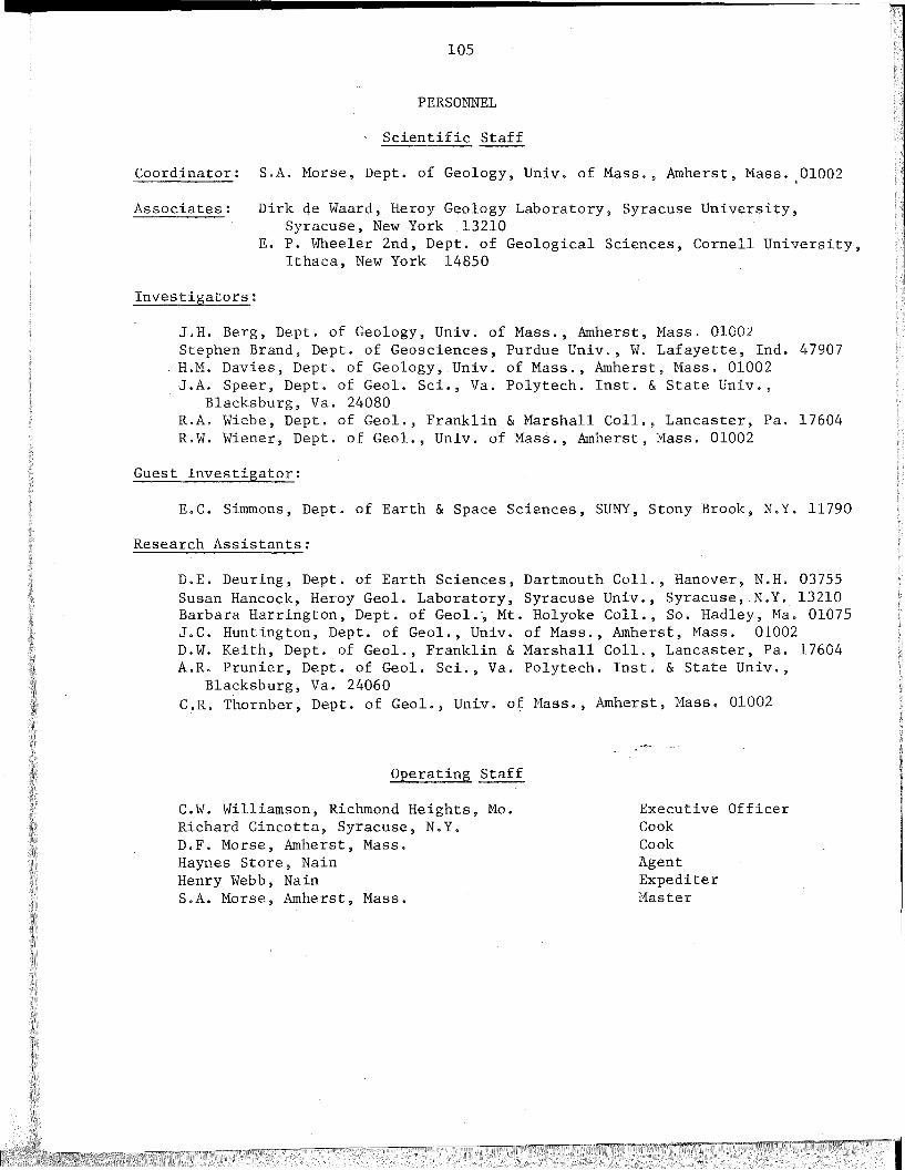
2
105
PERSONNEL
Scientific Staff
Coordinator: S.A. Morse, Dept. of Geology, Univ. of Mass., Amherst, Mass. ,01002
Associates: Dirk de Waard, Heroy Geology Laboratory, Syracuse University,Syracuse, New York 13210
E. P. Wheeler 2nd, Dept. of Geological Sciences, Cornell University,Ithaca, New York 14850
Investigators:
J.H. Berg, Dept. of Geology, Univ. of Mass., Amherst, Mass. 01002Stephen Brand, Dept. of Geosciences, Purdue Univ., W. Lafayette, Ind. 47907H.M. Davies, Dept. of Geology, Univ. of Mass., Amherst, Mass. 01002J.A. Speer, Dept. of Geol. Sci., Va. Polytech. Inst. & State Univ.,
Blacksburg, Va. 24080R.A. Wiebe, Dept. of Geol., Franklin & Marshall ColI., Lancaster, Pa. 17604R.W. Wiener, Dept. of Geol., Univ. of Mass., Amherst, Mass. 01002
Guest Investigator:
E.C. Simmons, Dept. of Earth & Space Sciences, SUNY, Stony Brook, N.Y. 11790
Research Assistants:
D.E. Deuring, Dept. of Earth Sciences, Dartmouth ColI., Hanover, N.H. 03755Susan Hancock, Heroy Geol. Laboratory, Syracuse Univ., Syracuse, N.Y. 13210Barbara Harrington, Dept. of Geol., Mt. Holyoke ColI., So. Hadley, Ma. 01075J.C. Huntington, Dept. of Geol., Univ. of Mass., Amherst, Mass. 01002D.W. Keith, Dept. of Geol., Franklin & Marshall ColI., Lancaster, Pa. 17604A.R. Prunier, Dept. of Geol. Sci., Va. Polytech. Inst. & State Univ.,
Blacksburg, Va. 24060C.R. Thornber, Dept. of Geol., Univ. of Mass., Amherst, Mass. 01002
Operating Staff
C.W. Williamson, Richmond Heights, Mo.Richard Cincotta, Syracuse, N.Y.D.F. Morse, Amherst, Mass.Haynes Store, NainHenry Webb, NainS.A. Morse, Amherst, Mass.
Executive OfficerCookCookAgentExpediterMaster
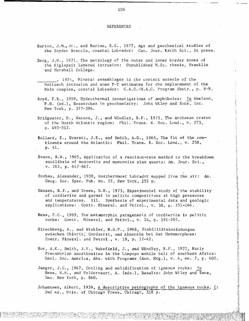
106
REFERENCES
Barton, J.M., Jr., and Barton, E.S., 1975, Age and geochemical studies ofthe Snyder Breccia, coastal Labrador: Can. Jour. Earth Sci., in press.
Berg, J.H., 1971, The petrology of the outer and inner border zones ofthe Kiglapait layered intrusion: Unpublished M.Sc. thesis, Franklinand Marshall College.
1974, Mineral assemblages in the contact aureole of theHettasch intrusion and some P-T estimates for the emplacement of theNain complex. coastal Labrador: G.A.C.-M.A.C. Program Abstr., p. 8-9.
Boyd, F.R., 1959, Hydrothermal investigations of amphiboles: In Abelson,P.H. (ed.), Researches in geochemistry: John Wiley and Sons, Inc.New York, p. 377-396.
Bridgwater, D., Watson, J., and Windley, B.F., 1973, The Archaean cratonof the North Atlantic region: Phil. Trans. R. Soc. Lond., v. 273,p. 493-512.
Bullard, E., Everett, J.E., and Smith, A.G., 1965, The fit of the continents around the Atlantic: Phil. Trans. R. Soc. Lond., v. 258,p. 41.
Evans, B.W., 1965, Application of a reaction-rate method to the breakdownequilibria of muscovite and muscovite plus quartz: Am. Jour. Sci.,v. 263, p. 647-667.
Forbes, Alexander, 1938, Northernmost Labrador mapped from the air: Am.Geog. Soc. Spec. Pub. No. 22, New York, 255 p.
Hensen, B.J., and Green, D.H., 1973, Experimental study of the stabilityof cordierite and garnet in pelitic compositions at high pressuresand temperatures. III. Synthesis of experimental data and geologicapplications:, Contr. Mineral. and Petrol., v. 38, ~ .. ±51-l66.
Hess, P.C., 1969, The metamorphic paragenesis of cordierite in peliticrocks: Contr. Mineral. and Petrol., v. 24, p. 191-207.
Hirschberg, A., and Winkler, H.G.F., 1968, Stabilitatsbeziehungenzwischen Chlorit~ Cordierit, und A1mandin bei der Meuamorphose:Contr. Mineral. and Petrol., v. 18, p. 17-42.
Hor. A.K., Smith, J.V., Wakefield, J., and Windley, B.F., 1972, EarlyPrecambrian anorthosites in the Limpopo mobile belt of southern Africa:Geol. Soc. America, Abs. with Programs (Ann. Mtg.), v. 4, no. 7, p. 602.
Jaeger, J.C., 1967, Cooling and solidification of igneous rocks: InHess, H.H., and Poldervaart, A. (eds.), Basalts: John Wiley and-Sons,Inc. New York, p. 860.
Johannsen, Albert, 1939, A descriptive petrography of the igneous rocks, I:2nd ed., Univ. of Chicago Press, Chicago, 318 p.

107
Krogh, T.E., and Davis,G.L., 1973, The significance of inherited zirconson the age and origin of igneous rocks - an investigation of the agesof the Labrador adame1lites: Carnegie Inst. Washington Year Book 72,p. 610-613.
Leake, B.E., 1968, A catalog of analyzed calciferous and subca1ciferousamphiboles together with their nomenclature and associated minerals:Geol. Soc. America Sp. Pap. 98, p. 210.
Morse, S.A., 1961, The geology of the Kiglapait layered intrusion, coastof Labrador, Canada: Ph.D. thesis, McGill University, Montreal, Canada, 319 p.
, 1969, The Kiglapait layered intrusion, Labrador: Geol. Soc.-...,...--...,...--America Memoir 112, 204 p.
Richardson, S.W., Gilbert, M.C., and Bell, P.M" 1969, Experimentaldetermination of kyanite-andalusite and andalusite-sillimaniteequilibria; the aluminum silicate triple point: Am. Jour. Sci., v.267, p. 259.
Runkle, D.E., and Saunders, M.J., 1974, Nukasorsuktokh Island blockstructure: A clue to the origin of anorthosites: Unpublished BAthesis, Mt. Holyoke College.
Smith, D., 1971, Stability of the assemblage iron-rich orthopyroxeneolivine-quartz: Am. Jour. Sci., v. 271, p. 370-382.
, 1974, Pyroxene-olivine-quartz assemblages in rocks associated--...,...-:----:-
with the Nain anorthosite massif, Labrador: Jour. PetrQlogy, v. 15,p. 58-78.
Streckeisen, A.L., 1973, Plutonic rocks-classification and nomenclaturerecommended by the lUGS Subcommission on the Systematics of IgneousRocks: Geotimes, v. 18, p. 26-30.
Tuttle, O.F., and Bowen, N.L., 1958, Origin of granite ±n the light ofexperimental s'tudies in the system NaA1Si308-KA1Si308-Si02-H20: Geol.Soc. America Memoir 74, 153 p.
Wheeler, E.P. 2nd, 1942, Anorthosite and associated rocks about Nain,Labrador: Jour. Geology, v. 50, p. 611-642.
, 1953, List of Labrador Eskimo Place Names: Nat. Mus. Canada------Bull. 131, 105 p.
, 1955, Adamellite intrusive north of Davis Inlet, Labrador:-----Geol. Soc. America Bull., v. 66, p. 1031-1060.
, 1960, Anorthosite-adamellite complex of Nain, Labrac'or: Geol.----:----:--
Soc. America Bull., v. 71, p. 1755-1162.
, 1968, Minor intrusives associated with the Nain anorthosite:------In Isachsen, Y.W. (ed.), New York State Mus. Sci. Servo Mem. 18,p. 189-206.
\
II

108
Wiebe, R.A., 1974, Coexlsting intermediate and basic magmas, Ingonish,Cape Breton Island: Jour. Geology, v. 82, p. 74-87.
Windley, B.F. 1969, Anorthosites of Southern West Greenland: Mem. Am.Assoc. Petrol. Geo1., v. 12, p. 899-914.
, 1971, The stratigraphy of the Fiskenaesset anorthosite----:-:--
complex: Gr~n1ands Geo1. Unders., Rapp. 35, p. 19.
, and Smith, J.V., 1971, Igneous mineral trends in a highgrade metamorphosed anorthosite complex, Fiskenaesset, West Greenland:Geo1. Soc. America, Abs. with Programs (Ann. Mtg.), v. 3, no. 7, p. 753.
Winkler, H.G.F., 1967, Petrogenesis of metamorphic rocks: SpringerVerlag, 237 p.