rpt on trenching lebel tp€¦ · grab samples as well as representative chip samples were taken...
TRANSCRIPT

32D04NW2029 2.20670 LEBEL 010
2.20670
RECEIVED
NOV Q 1 23C
GEOSCIENCE ASSESSMENT _____OfFICE
REPORT ON TRENCHINGON THE MOFFAT-HALL GOLD PROPERTY
LEBEL TOWNSHIP, LARDER LAKE MINING DIVISIONDISTRICT OF TIMISKAMING, ONT.
FOR GOLDAUR RESOURCES INC.
RECEIVEDLARDER LAKE
MINING DIVISION
OCT 30 2000
S.J. CARMICHAEL CONSULTANTS KIRKLAND LAKE ONTARIO NTS: 32 D/SW
SEPTEMBER 2000
32D04NW2029
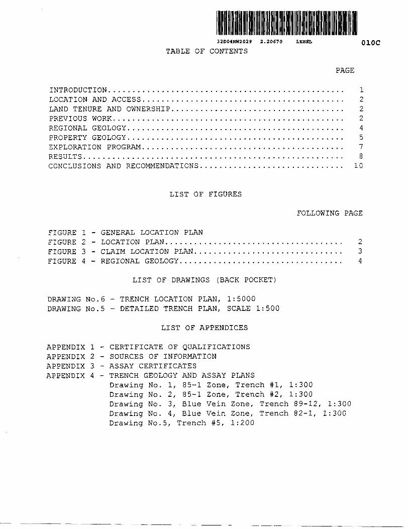
TABLE OF CONTENTS
2.20670 LEBEL 010C
PAGE
INTRODUCTION.LOCATION AND ACCESSLAND TENURE AND OWNERSHIP.PREVIOUS WORK.REGIONAL GEOLOGYPROPERTY GEOLOGY.EXPLORATION PROGRAM.RESULTS.CONCLUSIONS AND RECOMMENDATIONS
12224578
10
LIST OF FIGURES
FOLLOWING PAGE
FIGURE l - GENERAL LOCATION PLAN FIGURE 2 - LOCATION PLAN. FIGURE 3 - CLAIM LOCATION PLAN... FIGURE 4 - REGIONAL GEOLOGY.
234
DRAWING No.6 DRAWING No.5
LIST OF DRAWINGS (BACK POCKET)
TRENCH LOCATION PLAN, 1:5000 DETAILED TRENCH PLAN, SCALE 1:500
LIST OF APPENDICES
APPENDIX l APPENDIX 2 APPENDIX 3 APPENDIX 4
CERTIFICATE OF QUALIFICATIONSSOURCES OF INFORMATIONASSAY CERTIFICATESTRENCH GEOLOGY AND ASSAY PLANSDrawing No. l, 85-1 Zone, Trench #1, 1:300
2. 85-1 Zone, Trench #2, 1:3003. Blue Vein Zone, Trench 89-12,
Drawing No. Drawing No ,Drawing No. 4, Blue Vein Zone, Trench 82-1, Drawing No.5, Trench #5, 1:200
1:300 1:300
GEOLOGY ANDPRINCIPAL MINERALS
OF ONTARIO
Major Mineral Deposits Past and Present
Gold
Silver
iron
Copper- Nickel
Zinc-Copper
Platinum -Palladium
4- Uranium
Industrial Minerals
Scale i B 000 000
50 O 50 100 150 200 Kilometres
150 Miles
MOFFAT-HALL PROJECT
LEGEND"PHANEROZOIC
MESOZOIC
PALEOZOIC DEVONIAN SUPERIOR AND SOUTHERN PROVINCES
NEO-TO MESOPROTEROZOIC
Felsic intrusive rocksSedimentary rocks
SILURIANSedimentary rocks
ORDOVICIAN
Sedimentary rocks
Mafic intrusive rocks
volcanic and sedimentary rocks
PALEOPROTEROZOfC
Mafic intrusive rocksCAMBRIAN
Sedimentary rocksMetasecJimenlary and metavoJcanic rocks
PRECAMBRIANGRENVILLE PROVINCE
PROTEROZOICNEO- TO MESOPROTEROZOIC
X Mlgmathic rocks and gneisses
SUPERIOR PROVINCE ARCHEAN
NEQ- TO MESOARCHEANMassive lo lolialed granodiortie to
Foliated to gneissic tonalite to granodiorite
Malic to ultramafic plutonic MESOARCHEANMetavoteanic and metasedimenlary rocksFelsic plutonic rocks, denved
gneisses and migmaiiiesMet a sedimentary rocks and derivedgneisses
* Prianefozoic units are lithostratigraphic, whereas Precambrian units are lithologic.
e 1995 Queen's Primei tor Ontario
n Drtario, CanadaMe ta volcan i c and mefasedimentary rocks
Metavoteanic andm eia sediment a ry rocks
FIGURE l - GENERAL LOCATION PLAN
REPORT ON TRENCHING ON THE MOFFAT-HALL GOLD PROPERTY
LEBEL TOWNSHIP LARDER LAKE MINING DIVISION
DISTRICT OF TIMSIKAMING, ONT.FOR
GOLDAUR RESOURCES INC.
INTRODUCTION
This report on Goldaur Resources Inc. Moffat-Hall gold
property has been prepared by S.J. Carmichael Consultants at the
request of Goldaur Resources Inc. It describes trenching, mapping
and sampling programs completed between July and August 2000.
Five trenches were excavated, two tenches over the "85-1
Zone, " two over the "Blue Vein Zone" and one located 300 metres
southeast of the 85-12 Zone. The trenches over the 85-1 and Blue
Quartz Zones were washed, mapped in detail and sampled using a
"first pass" representative chip samples. Areas of interest were
then re-sampled using industry standard cut channel samples. The
fifth trench could not be washed leaving poor bedrock exposure.
Grab samples as well as representative chip samples were taken from
this trench.
The purpose of the program was to determine if the 85-1 Zone
and Blue Vein Zones are continuous and share a common structure(s).
Mapping was completed by this author with sampling completed
by T. Link and J. Forbes. All work was supervised by this author.
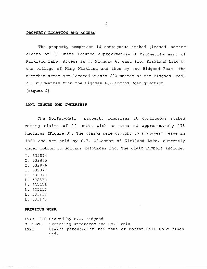
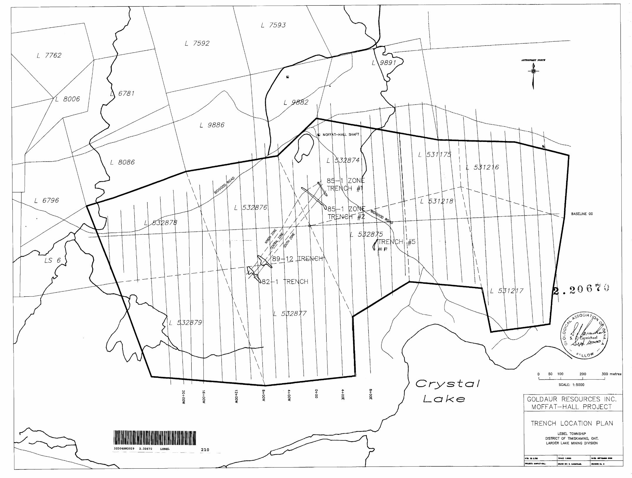
PROPERTY LOCATION AND ACCESS
The property comprises 10 contiguous staked (leased) mining
claims of 10 units located approximately 8 kilometres east of
Kirkland Lake. Access is by Highway 66 east from Kirkland Lake to
the village of King Kirkland and then by the Bidgood Road. The
trenched areas are located within 600 metres of the Bidgood Road,
2.7 kilometres from the Highway 66-Bidgood Road junction.
(Figure 2)
LAND TENURE AND OWNERSHIP
The Moffat-Hall property comprises 10 contiguous staked
mining claims of 10 units with an area of approximately 178
hectares (Figure 3) . The claims were brought to a 21-year lease in
1988 and are held by F.T. O'connor of Kirkland Lake, currently
under option to Goldaur Resources Inc. The claim numbers include:
L. 532874 L. 532875 L. 532876 L. 532877 L. 532878 L. 532879 L. 531216 L. 531217 L. 531218 L. 531175
PREVIOUS WORK
1917-1918 Staked by F.C. Bidgood C. 1920 Trenching uncovered the No.l vein1921 Claims patented in the name of Moffat-Hall Gold Mines
Ltd.


1923 Optioned to by Tonopah Mining Company, completed surface prospecting
1928 Optioned to Mcintyre Porcupine Mines Ltd., completed unspecified development, name changed to Moffat-Hall Mines Ltd.
1931-1932 A 2-compartment shaft was sunk to 550 feet with levels at 150, 300, 425 and 550 feet opened, 1,200 feet of cross cutting and l,600 feet of drifting
1934 Property was leased to H. Jardin who shipped 3,178 tons ore to the Noranda Mill which produced $166,569.00 gold value. (Gold at $35.00/oz)
1934-35 Leased to Bidgood Kirkland Gold Mines Ltd. A raise was driven to connect the Moffat-Hall 425-foot level with the Bidgood 500-foot level and production continued until July 1935.At some unknown period, before the mine was flooded in 1936, Sylvanite Gold Mines Ltd. Sampled and mapped the underground workings. Sylvanite Gold Mines also drilled in the mine and the "Discovery Vein" areas.
1936 Operations resumed briefly under the name of Moffat-Hall Mining Co. Ltd. During the life of the mine there were 4,365 feet of underground development and 3,464 feet of underground diamond drilling in 21 holes. Recorded production comprises 4,768 oz. Au, 1,149 oz. Ag from 16,388 tons of milled ore for a recovered grade of 0.20 oz/ton (1934-36)
1937-1943 Moffat-Hall Mining Co. Ltd. drilled 27 surface holes on the "Boundary Vein", "Blue Vein" and the "Bidgood Break" areas.
1953 Open for staking January lst/1953.1954 Upper Canada Mines Ltd. trenched, sampled and drilled 12
holes on the "Blue Vein"1958 Staked by MacNamara et al.1962 Surface trenching located gold-bearing shear zone 3,000
feet east of shaft.1964 Consolidated Virginia Mining Corporation completed line-
cutting and cleaning out, sampling and mapping of old trenches.
1965-1966 Tegren Gold Mines Limited drilled six holes totalling 688 feet.
1973 Trenching and stripping by E.G. Deloye1980-1985 During 1980 ENR Partnership optioned the property from F.

3010 3011
L 30/09t* 23
X779*
1239091 982330 ^982333L. a*e
ii
;| : —C '981931 i 981938! T ; l' .a! ^* ^^—-i————— 982318 982322" p5u-r-*- T^*^ l i - l 982325
\ - 3*03.—l" v.981930
"•420
fU l98192B {981929
(
j- /^~".- — s
? L - , - , -
982328 i 982331 ' 982332' l '982337
3O94
8*39
^1225271
3B47
It
\ 981928- 981927 li .^
7T4O
774430*4
3037 I4I43
982319
74047799
aoit-.
14023I4I32
U I4I3S
' 74O77761
144440 I4O4
N^12200191^.11
t^u 12201 af3900- J
4OI87O4OI34*-
74IB .
—————|L3
l . ioa
""M M 225285
-3?"X53287JS \
' 73B3. \ \'*480 l ; I447B \ "^ —.1 l *
^\,
,s3991
______ , _r ^ , S31175 | 531216
* r" 532874 i -,- —*-^ ^532876 \ "*
— - V
9*39 9*34
S
327 i.' L
531217
8*33 | 9932
249^532879 \ ' 532877
'32.90
*TJa •408272
US447
7419
2327
3180
e "eCrystal
1220182'
A
4M
'-^
4*"
7*7*
8934
III
•i. ^7 HO
J'^
' LV ?S525
LA '•**-f L *.so11-8*438 { l-** T* l j 1.9*200
LM Z1 -f".
t 74909 t ^aeis
l Ll IO*IO44424 l
1 7M3S
.982175
89*98r . - r M93BO
l L 550032 -
us10*
-3Mx
U
494 4979484
o
m- . -' t - *J —. L2—FIGURE 3 - CLAIM LOCATION PLAN
1:20 0009469
g

O'connor. In 1981 ENR was absorbed by Silver Lake Resources Inc. Silver Lake Resources Inc. completed 18.8 miles of linecutting, magnetometer survey, VLF-EM survey, an I.P. survey on claim L. 531175 and 21,141 feet of diamond drilling in 33 holes near the Moffat-Hall Mine, the "Blue Vein" and the "Bidgood Break".
1988-1999 International Platinum Corporation completed 6.5 miles of I.P., selected mis a la masse and 21 diamond drill holes totalling 7,744 feet.
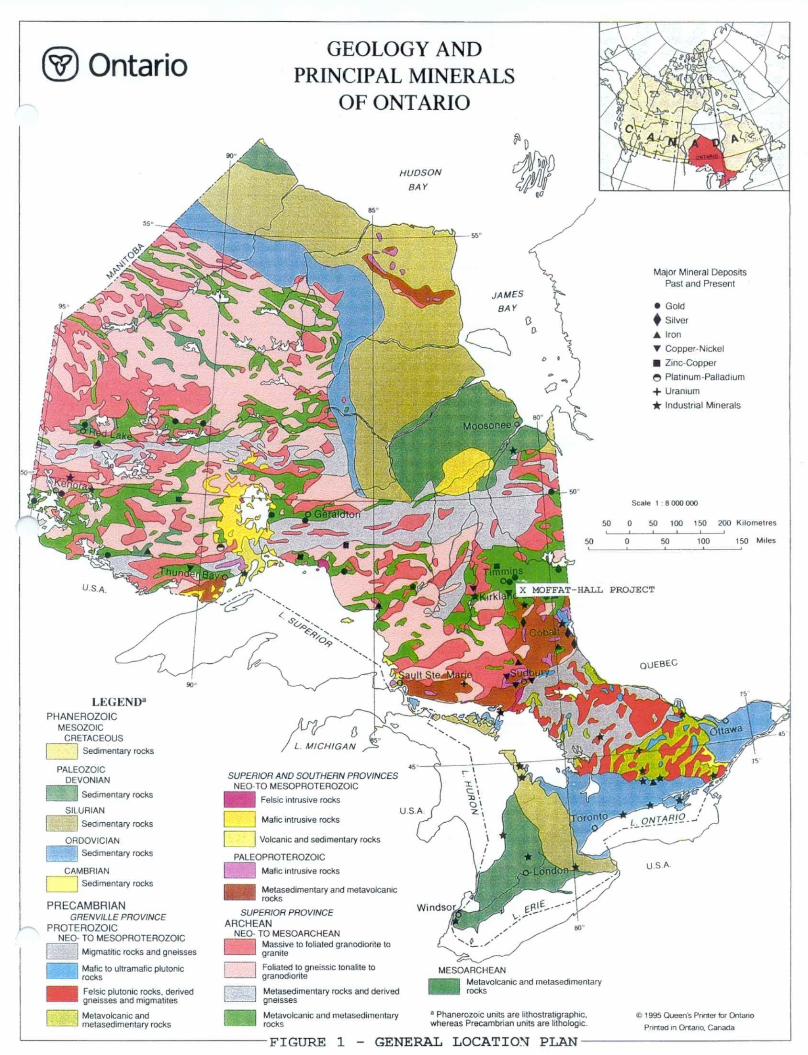
REGIONAL GEOLOGY
The Moffat-Hall property lies within the Abitibi Greenstone
Belt of Neo-Archean age located in the southeastern portion of the
Superior tectonic province. The Abitibi belt is the largest and
most continuous greenstone belt in the Canadian Shield, extending
some 700 km from east to west with a width of approximately 200 km
and is of Archean age. It is bound to the east by the Grenville
Front and to the west by the Kapuskasing Structure. The belt
consists of repetitive volcanic cycles ranging from ultramafic to
felsic in composition. Clastic sediments are intercalated with the
volcanic rocks, and in narrow fault bounded zones. Ultramafic to
mafic intrusions as well as granitoid complexes exist.
The dominant structural style of the belt reflects the
presence of local granitoid bodies with concordant external
structures, the east-west trending isoclinal folds of regional
extent. The belt has been deformed into a major east-west trending
synclinorium that transects the central portion of the Ontario
segment of the Abitibi belt.
Within the southern part of the belt, many steeply dipping,
east-west trending discontinuous shear zones of undetermined
displacement have been identified. Two major breaks have been

NORTHERN FAULT-BLOCK
WATABEAG ^ ATHO- ^
^ 12 \~~
ProterozoicKeeweenawan diabase (not shown)
12 Cobalt Group Archean
Matachewan diabase (not shown! Granitic rocks
11 Granodiorite, monzonite, quartz monzonite,syenite
10 Massive to gneissic quartz diorite, tonalite.trondhjemite
Upper Supergroup9 9a' Timiskaming Group, 9b** Destor -
Porcupine Complex8 8a, 8n, Blake River Group, 8c'** Blake
River (Upper Fm., Tisdale Group)
7 7a. 7b, Kinojevis Group, 7c Kinojevis Group,(Middle Fm., Tisdale Group)
6 6a Larder Lake Group, 6b Stougnton-Roquemaure Group, 6c Lower Fm., TisdcleGroup
5 5c Porcupine Group Lower Supergroups
4 4a Skead Group, 4b Hunter Mine Group, 4cUpper Fm.. Deloro Group
3 3a Catherine Group, 3c Middle Fm.. DeloroGroup
2 2a Wabewawa Group, 2c Lower Fm.. DeloroGroup
1 1a Pacaud tuffs ••**
*a refers to Kirkland Lake Area, south limb of synclinorium (Jensen 1978c. 1979)."b refers to Kirkland Lake Area, north limb of synclinorium (Jensen 1976. 1978bl.*••c refers to Timmins Area (Pyke 1980)**** (Goodwin 1965).
FIGURE 4 - REGIONAL GEOLOGYFROM JENSEN AND LANGFORD, 1985
identified including the Porcupine-Destor and Larder Lake breaks.
These breaks follow lithofacies boundaries for the most part,
including sedimentary volcanic interfacies. Many of the gold
deposits of the area are closely associated with the major shear
zones and splays, especially in the Kirkland Lake-Larder Lake and
Malartic-Cadillac areas. Approximately 75*^ of historical gold
production in Canada is derived from the Abitibi belt.
The Kirkland Lake area is dominated by what is called the
Upper Volcanic Cycle comprising a lower ultramafic sequence (Larder
Lake Group) disconformably overlain by a tholeiitic sequence
(Kinojevis Group) which is in turn disconformably overlain by a
calc-alkalic sequence (Blake River Group). This entire sequence is
unconformably overlain by the Timiskaming Series of clastic
sediments and felsic volcanics. All of the above have been intruded
by stocks and bosses of mafic to syenitic composition and diabase,
also of late Archaean age. The regional geology is shown in figure
4.
PROPERTY GEOLOGY
Lebel Township, including the Moffat-Hall property was mapped
at a scale of I'^l,000 ft. by Ontario Department of Mines geologist
A. Maclean in 1956 (map 53a) . Maclean's work shows the entire
Moffat-Hall property as underlain by Timiskaming Series sediments
and volcanics intruded by porphyrite, a generic term used to
describe partially digested sediments and feldspar +- quartz
porphyry.
In general the property may be divided into two geological
domains. The west portion on the property is underlain by a large

intrusive mass called, in previous work, porphyrite. This rock is
typically a fine to medium-grained light grey to buff (depending
upon sericite content) silicious feldspar H quartz porphyry with
the feldspar phenocrysts averaging 5mm in size. The term porphyrite
was used to describe the intrusive porphyry as well as partially
digested sediments such that no definite contacts are evident.
The east portion of the property is underlain by dark green
chloritized sediments or tuffs with trachytic flows striking west-
northwest dipping steeply north, locally folded to an east-
northeast strike due to feldspar porphyry intrusives. These rocks
have been metasomatized in part with the introduction of hematite,
carbonate and pyrite mineralization and locally have a "baked"
appearance. They have been subsequently intruded by a massive
brick-red/mauve massive feldspar porphyry dike 16-20 metres in
width, not related to the larger massive to the west. A number of
strong northeast striking north-dipping shear zones/faults were
identified intersecting the sediments over the eastern portion of
the property. The shearing has resulted in alteration of the
sediments to sericite+-carbonate+-pyrite schists and associated
rusty carbonate gouge over widths of up to 4 metres. These
structures may be traced with confidence to the west where they
intersect the main feldspar porphyry intrusive. The intersection of
these structures with the porphyry has resulted in brittle
deformation of the porphyry with associated silicification,
sericite alteration, minor quartz veining and sulphide
mineralization comprising up to IQ% pyrite and minor molybdenite.
The molybdenite mineralization has imparted a blueish tinge to the
porphyry and has been termed in the past as "Blue Quartz Zones" or
"Blue Vein Zones." The Blue Quartz Zones have been further

7
subdivided into the North, Central and South Zones.
The 85-1 Zone is located 350 metres northeast and on strike of
the Blue Vein Zone and is named after drill hole 85-1 which
intersected 3.80 gms/tonne Au over a core length of 1.52 metres.
Mineralization comprises narrow pyritic shear zones located within
either altered sediments/chloritic tuffs or possible trachyte near
the margins of feldspar porphyry dikes. These bimodal dikes are
generally brick red/brown in colour and likely younger than the
porphyry massif which hosts the Blue Vein Zone. At least three
mineralized shear zones have been identified and appear to be
contiguous with the North, Central and South Blue Vein systems.
EXPLORATION PROGRAM
Two trenches were excavated over the eastern portion of the
property, two trenches over the western portion ("Blue Quartz
Zones") and one additional trench (#5) to the southeast near a
historical drill hole which graded 0.38 oz/ton Au over 1.0 feet.
The location and dimension of the trenches are tabulated below:
TRENCH # LOCATION* LENGTH AZIMUTH VOLUME OF MATERIAL**REMOVED
85-1 Zone, Tr-1 2+78E, 4+72N 76m 3260 357m385-1 Zone, Tr-2 0+61W, 5+27N 152m 309 0 943m389-12 Zone, Tr-3 8+OOW, 4+OOS 87m 130" 1060m382-1 Zone, Tr-4 9+59W, 5+59S 94m 140 0 1103m3Trench #5 9+20E, 3+68S 54m 028 0 200m3
* Measured from trench grid coordinate 0,0 to existing Moffat-Hall
grid.
** The average overburden depth is l metre thus the trenched areas
in m2 are the same as the trench volumes.

8
With the exception of Trench #5, all trenches were washed and
mapped at a scale of 1:200 metric and plotted at a scale of 1:300.
The entire trenches were then sampled using representative chips
taken at either 2 metre intervals or l metre intervals over
mineralized zones and/or alteration/shear zones using geological
controls. Selected areas of mineralization grading >l.0 gm/tonne Au
were then sampled using industry standard sawed channel samples.
Due to a lack of available water, Trench #5 was not washed and
was sampled using representative chip or grab samples. The trench
was mapped at a scale of 1:200 and plotted at a scale of 1:200.
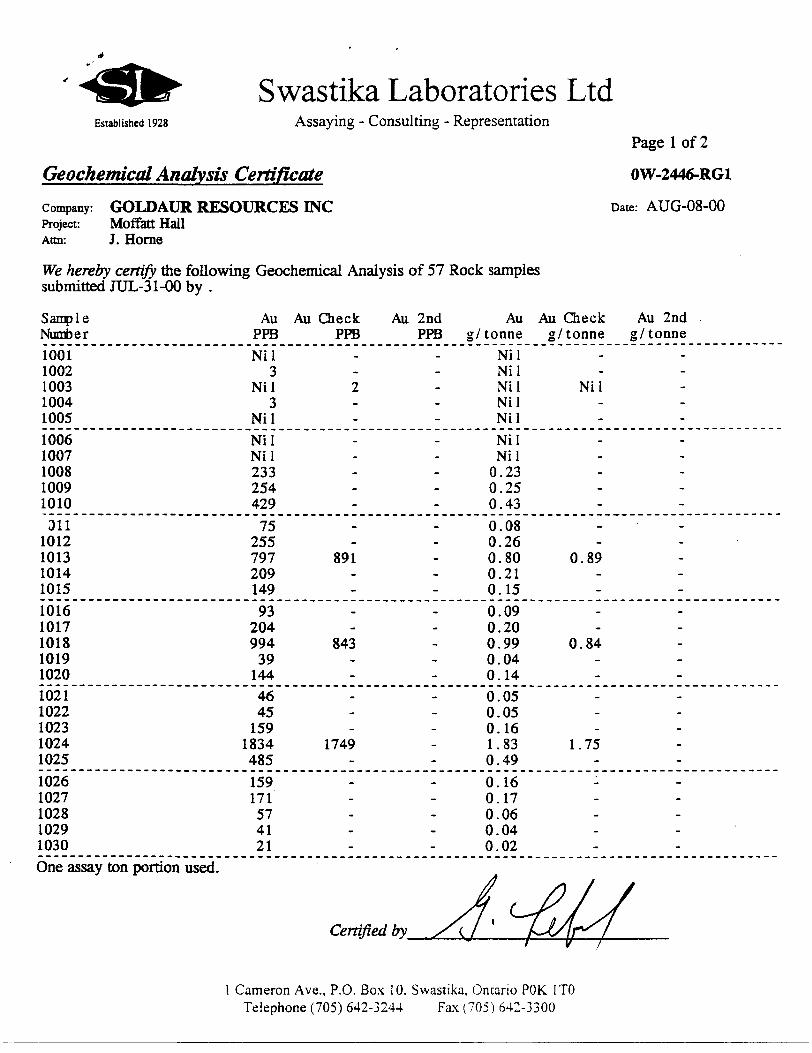
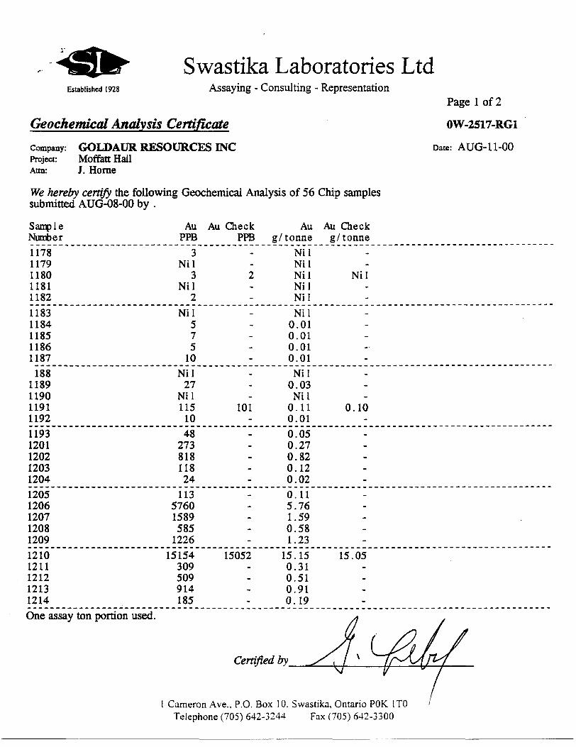
All samples were then transported by this author to Swastika
Laboratories and were analysed using conventional fire assays.
RESULTS
The results of the sampling are tabulated in Table l, the
trench assay and geology plans are included in Appendix 4.
The 85-1 Zone comprises three parallel shear zones striking
040 0-0500 dipping 68-75 0 north. On surface they occur as
sericite/carbonate schist and rusty carbonate fault gouge
mineralized with up to 10 !fe disseminated and semi-massive blebs of
pyrite. The host rocks are difficult to distinguish as they have
undergone metasomatic alteration due to the large porphyry massif
to the southwest which hosts the Blue Vein Zones. The alteration
has resulted in chloritization, widespread pyrite mineralization
and a local "baked" appearance. The host rocks may be either
sediments or mafic tuffs or trachytic tuffs. In trench 85-1-Trench
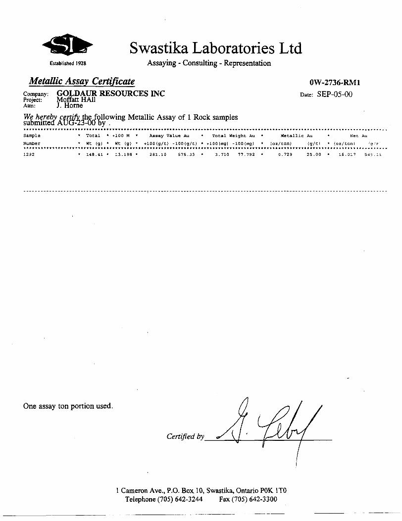
#1 the South Zone assayed 95.08 gms/tonne Au over 2.7 metres.
Subsequent investigations of this zone revealed no visible gold but

TABLE l
85-1 ZONE
TRENCH #
85-1 Trenchttl
85-1 Trench#2
BLUE VEIN ZONE
TRENCH #
89-12 Trench
Offset Channel
82-1 Trench
ZONE
SouthCentralNorth*
SouthCentralNorth
ZONE
SouthCentralNorth
Central
SouthCentralNorth
CHIP SAMPLE RESULT
4.39 gms74.0m 0.85 gms70.7m Not Present
2.71 gms72.0m 1.18 gms/l.Om 2.58 gms/l.Om
CHIP SAMPLE RESULT
2.83 gms/l.Om1.43 gms74.9m1.44 gmsM.Om
Not Sampled
CHANNEL SAMPLE RESULT
95.08gmsX2 .7mNot sampled Not Present
1.641.79 gms/O.Sm0.85 gms/l.Om
1.70Not SampledNot sampled
CHANNEL SAMPLE RESULT
1.11 gms/l.Om 3.37 gms/S.Om 1.43 gmsA.4m
1.91 gms^.4m
1.04 gms/l.Sm 2.13 gms/O.Sm 0.76 gms/l.Om
Trench #5 No Significant Values
* Trench 85-1 was not excavated far enough north to uncover the North Zone due to topography.

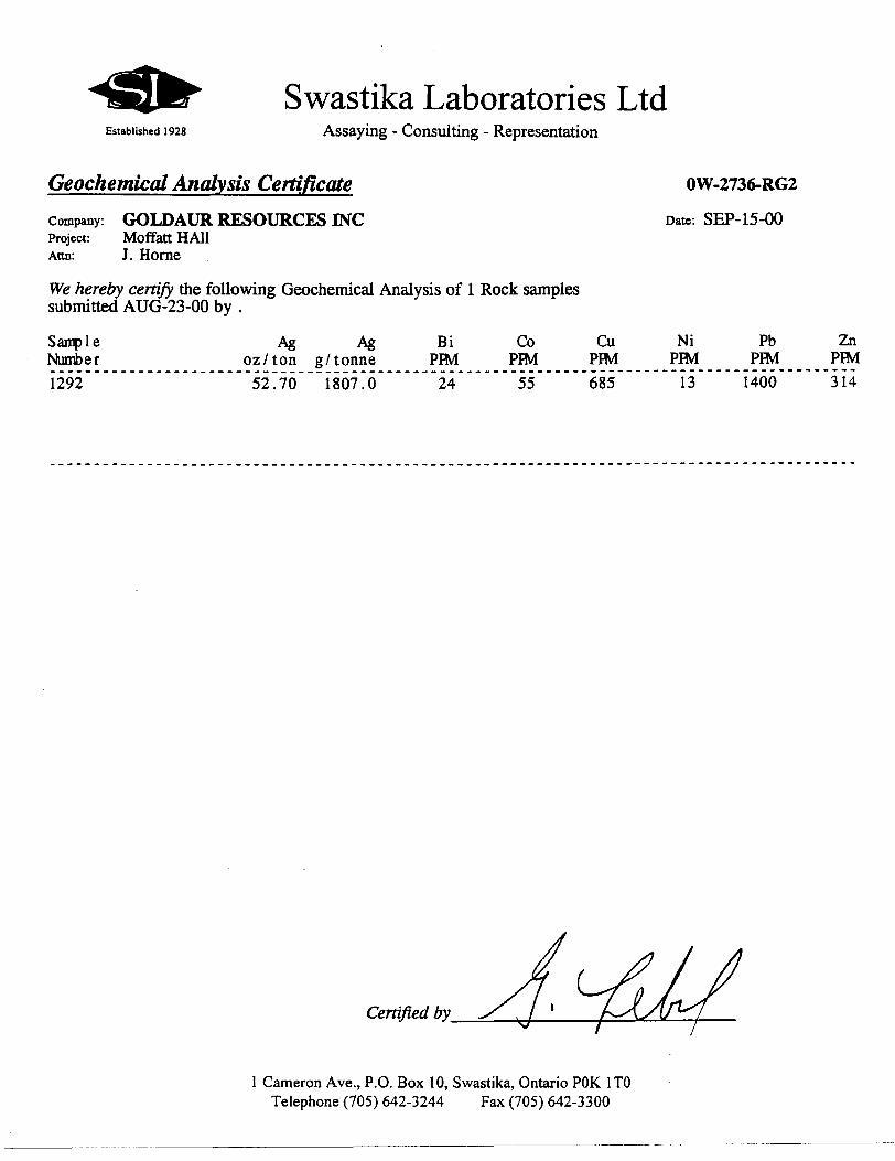
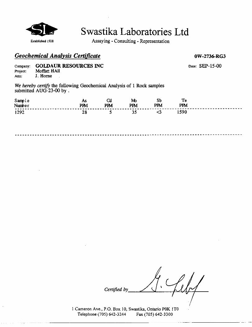
further assaying revealed high concentrations of Tellurium (1,590
ppm), Silver (1,807 gms/tonne) indicating the presence of a gold-
silver telluride. With the exception of the above described
intersection, the shear zones exhibit anomalous gold mineralization
ranging from 1-2.5 gms/tonne Au over widths of 1-2 metres.
The three mineralized shear zones located in the 85-1 trenches
may be traced with confidence to the Blue Vein Zone where they are
defined as the North, Central and South Zones as well. The host
rock over the Blue Vein Zone has been variably described as
porphyrite, porphyritized conglomerate, feldspar crystal tuff,
lapilli tuff, and by this author, feldspar porphyry. There is no
indication of bedding and the massif appears to be of irregular
shape indicating an intrusive origin. The porphyry is generally
light grey in colour, massive, fine-grained with feldspar
phenocrysts 3-4mm in size. The slight buff colour indicates
possible sericite dusting of the groundmass.
Mineralization within the porphyry is confined to shear zone
related brittle deformation which has resulted in shattering of the
porphyry over widths of 3-4 metres. These shear zones strike from
040 0-050 0 dipping vertical to steeply north and are characterised
by sericite -l carbonate alteration increasing toward a
silicified/sericitized core of the brittle deformation. This
silicified core is distinguished by a subtle blue tinge, possibly
related to minor molybdenite mineralization resulting in the Blue
Quartz or Blue Vein description. Gold mineralization is directly
associated with elevated quartz and up to S-10% pyrite
mineralization. Assay values range from 1-3 gms Au over widths of
1-5 metres. The entire porphyry massif contains anomalous gold
mineralization, but generally < 0.1 gms/tonne Au, the exception

10
being trench 89-12 which would average roughly 0.61 gras/tonne Au
over 55 metres. An isolated assay from trench 89-12 returned 16.42
gms/tonne Au over 1.0 metres but could not be verified by a channel
sample. The mineralization would lie between the North and Central
Zones.
CONCLUSIONS AND RECOMMENDATIONS
Gold mineralization on the Moffat-Hall 85-1 and Blue Vein
Zones is localized along three parallel shear structures and
subdivided as the North, Central and South Zones. These structures
appear to be linear and contiguous between the Blue Quartz and 85-
1 Zones with a strike length in excess of 500 metres, and open at
either end.
Two areas require further exploration. The 85-1 South Zone as
intersected in Trench #1 (95.08 gms/tonne Au over 2.7 metres)
should be drilled east of this trench where an increase in
overburden does not allow trenching. Additional trenching along
strike southwest of the 85-1 Zone Trench #2 should be considered as
well.
The contact between the main porphyry massif which hosts the
Blue Vein Zone, and the altered sediments/volcanics should be
tested by either trenching or diamond drilling, particularly where
cut by the three above mentioned shear zones. This contact would
lie somewhere between the 85-1 Zone Trench #2 and the Blue Quartz
Zone 89-12 Trench.
Respectfullyysubr
S.J. Carmichae
Consulting Geo

11
APPENDIX I
Certificate of Qualifications
I, Stewart J. Carmichael, of the Town of Kirkland Lake, in the District of Timiskaming, in the Province of Ontario, Canada, do hereby certify that:
1) I am a consulting geologist with address 42 Rand Avenue East, Kirkland Lake, Ont . P2N 1X1.
2) I am a graduate of McMaster University, Hamilton, Ontario, having received the degree of Bachelor of Science, Geology from the Faculty of Science in 1982 . I have since practised in the field of mineral exploration continuously since graduation.
3) I am a Fellow of the Geological Association of Canada.
4) I have no direct or indirect interest in the Goldaur Resources Inc. Mof fat-Hall property.
5) In addition to my personal knowledge of the area, I have made use of the records of the Ministry of Natural Resources of Ontario in the preparation of this report.
6) I supervised and was on site for the Goldaur Resources Inc. Moffat-Hall trenching program.
Dated this day/of SepiemtSe'r 2000
Stewart J. Carmichael, B.Se., FGAC
12
APPENDIX 2
SOURCES OF INFORMATION
Gordon, J.B., Lovell, H.L., de Grijs, Jan and Davie, R.F.1979: Gold Deposits of Ontario, Part 2: Part of District of Cochrane, Districts of Muskoka, Nipissing, Parry Sound, Sudbury, Timiskaming and Counties of Southern Ontario; Ontario Geological Survey, Mineral Deposits Circular 18, 253p.
Jensen, L.S., and Langford, F.F. 1985: Geology and Petrogenesis of the Archean Abitibi Belt in the Kirkland Lake Area, Ontario; Ontario Geological Survey, Miscellaneous Paper 123, 130p.
Lovell, H.L., 1976: The Geology of Lebel Township, District ofTimiskaming, Ontario Department of Mines; OFR5211, 145p., 5 tables, l figure, l photo. Accompanied by Chart A, scale 1:12,000
Maclean, A. Geology of Lebel Township, Ontario Department of Mines Bulletin 150 accompanied by Map No. 53a.
O.G.S., 1979: Airborne Electromagnetic and Total Intensity Magnetic Survey, Kirkland Lake Area, Lebel Township, District of Timiskaming by Questor Surveys Limited for the Ontario Geological Survey. Prelim. Map P.2264, Geophysical Survey, scale 1:20,000. Survey and compilation, February and March, 1979.
Ploeger,F., Campbell, A. and Gabrowski1979: Lebel Township, District of Timiskaming; Ontario Geological Survey Preliminary Map P.2009, Kirkland Lake Data Series. Scale 1:15,840 or l inch to 1/4 mile. Data compiled in 1978
Savage, W.S., 1964: Mineral Resources and Mining Properties inthe Kirkland Lake-Larder Lake Area; Ontario Department of Mines, Mineral Resources Circular No. 3, 108p.
Kirkland Lake Assessment FilesKL-0768 - 1980 E.N.R. Partnership Ltd. Moffat-Hall Gold Property

13
APPENDIX 3 ASSAY CERTIFICATES
Swastika Laboratories LtdEstablished 1928 Assaying - Consulting - Representation
Page l of 2
Geochemical Analysis Certificate ow-2446-RGiCompany: GOLDAUR RESOURCES INC Date: AUG-08-00Project: Moffatt HallAttn: J. Horne
We hereby certify the following Geochemical Analysis of 57 Rock samples submitted JUL-31-00 by .
Sample Number1001 1002 1003 1004 10051006 1007 1008 1009 1010
311 1012 1013 1014 1015
1016 1017 1018 1019 10201021 1022 1023 1024 1025
1026 1027 1028 1029 1030
Au PPBNil
3 Nil
3 NilNil Nil 233 254 429
75 255 797 209 149
93 204 994 3914446 45 159
1834 485
159171 57 41 21
Au Check PPB
2
-
891
843
1749
-
Au 2nd Au Au Check PPB g/ tonne g/ tonne
Nil Nil Ni 1 Ni 1 Nil NilNil Nil 0.23 0.25 0.43
0.08 0.26 0.80 0.89 0.21 0.15
0.09 0.20 0.99 0.84 0.04 0.140.05 0.05 0.16 1.83 1.75 0.49
0.16 0.17 0.06 0.04 0.02
Au 2nd g/ tonne
-
-
-
-
-
-
One assay ton portion used.
Certified by_
l Cameron Ave., P.O. Box 10. Swastika. Ontario POK l TO Telephone (705) 642-3244 Fax (705) 642-3300

Established 1928
Swastika Laboratories LtdAssaying - Consulting - Representation
Geochemical Analysis CertificateCompany: GOLDAUR RESOURCES INCProject: Moffott HallAttn: J. Horne
We hereby certify the following Geochemical Analysis of 57 Rock samples submitted JUL-31-00 by .
Page 2 of 2
OW-2446-RG1
Date: AUG-08-00
Sample Number
1031 1032 1033 1034 1035
1036 1037 1038 1039 1040
i041 1042 1043 1044 10451046 1047 1048 1049 10501051 1052 1053 1054 1055
1056 1057
Au PPB231 31
127 233 341
367 374 1303 1013 2484141 79 120 135 61579 27 69 12 6721 15 24 12 93
994
Au Check PPB
-
1071
2366
633
-
-
1029
Au 2nd Au PPB g/ tonne
0.23 0.03 0.13 0.23 0.34
0.37 0.37 1.30 1.01
2606 2 . 480.14 0.08 0.12 0.14 0.620.08 0.03 0.07 0.01 0.070.02 0.02 0.02 0.01 0.01Nil 0.99
Au Check g/ tonne
-
1.07
2.37
0.63
-
-
1.03
Au 2nd g/ tonne
-
2.61
-
-
-
-
One assay ton portion used.
Certified by
l Cameron Ave., P.O. Box 10. Swastika, Ontario POK l TO Telephone (705) 642-3244 Fax (705) 642-3300

Swastika Laboratories LtdEstablished 1928 Assaying - Consulting - Representation
Geochemical Analysis CertificateCompany: GOLDAUR RESOURCES INCProject: Moffat HallAttn: J. Horne
We hereby certify the following Geochemical Analysis of 61 Rock samples submitted AUG-01-00 by .
Page l of 2
OW-2457-RG1
Date: AUG-09-00
Sample Number1058 1059 1060 1061 1062
1063 1064 1065 1066 1067
'068 069 1070 1071 1072
1073 1074 1075 1076 10771078 1079 1080 1081 10821083 1084 1085 1086 1087
Au Au Check PPB PPB302127 147 823 2991406 1611 1714 1015 1474 765
537 861 521 134 139293 153 295 350
17040 16286202 173 489 399 259173 533 130 96
2023 1851
Au 2nd Au Au Check PPB g/ tonne g/ tonne
0.30 0.13 0.15 0.82 0.301.41 1.61 1.71 1 . 02 1.47 0.76
0.54 0.86 0.52 0.13 0.14
0.29 0.15 0.29 0.35
15943 17.04 16.290.20 0.17 0.49 0.40 0.260.17 0.53 0.13 0.10 2.02 1.85
Au 2nd g/ tonne
-
-
-
15.94
-
-
One assay ton portion used.
Certified by-
Cameron Ave., P.O. Box 10, Swastika, Ontario POK l TO Telephone (705) 642-3244 Fax (705) 642-3300

Established 1928
Swastika Laboratories LtdAssaying - Consulting - Representation
Geochemical Analysis CertificateCompany: GOLDAUR RESOURCES INCProject: Moffat HallAttn: J. Horne
We hereby certify the following Geochemical Analysis of 61 Rock samples submitted AUG-01-00 by .
Page 2 of 2
OW-2457-RG1
Date: AUG-09-00
Sample Number1088 1089 1090 1091 1092
1093 1094 1095 1096 "Q97
1098 1099 1100 1101 11021103 1104 1105 1106 11071108 1109 1110 1111 1112
1113 1114 1115 1116 11171118
Au Au Check PPB PPB406 1783 1714 14401337 173
391 146 147 619243
115 310 610 435
2846 2811789 885 5857 7234 14 9
21 24 9914 27 130 250 519365
Au 2nd Au Au Check PPB g/ tonne g/ tonne
0.41 1.78 1.71 1 . 44 1.34 0.17
0.39 0.15 0.15 0.62 0.24
0.11 0.31 0.61 0.44 2.85 2.810.79 0.88 0.06
. 0.06 0.07
0.03 0.01 0.01 0.02 0.02 0.10
0.01 0.03 0.13 0.25 0.520.377
Au 2nd g/ tonne
-
-
-
-
-
-
jOne assay ton portion used.
Certified by
l Cameron Ave., P.O. Box 10, Swastika, Ontario POK. l TO Telephone (705) 642-3244 Fax (705) 642-3300
Established 1928
Swastika Laboratories LtdAssaying - Consulting - Representation
Geochemical Analysis Certificate
Company: GOLDAUR RESOURCES EVCProject: Moffatt HallAttn: J. Horne
We hereby certify the following Geochemical Analysis of 56 Chip samples submitted AUG-08-00 by .
Page l of 2
OW-2517-RG1
Date: AUG-11-00
Sample Number
1178 1179 1180 1181 1182
1183 1184 1185 1186 1187188
1189 1190 1191 11921193 1201 1202 1203 12041205 1206 1207 1208 12091210 1211 1212 1213 1214
Au Au Check PPB PPB
3 Nil
3 2 Nil
2
Nil 5 7 5 10
Nil 27
Nil 115 101 1048
273 818 118 24113
5760 1589 585 1226
15154 15052 309 509 914 185
Au g/ tonne
Nil Nil Nil NilNil
Nil 0.01 0.01 0.01 0.01Nil 0.03 Nil
0.11 0.010.05 0.27 0.82 0.12 0.020.11 5.76 1.59 0.581.23
15.15 0.31 0.51 0.91 0.19
Au Check g/ tonne
Nil
-
0.10
-
-
15.05
One assay ton portion used.
Certified by
l Cameron Ave., P.O. Box 10. Swastika, Ontario POK l TO Telephone (705) 642-3244 Fax (705) 642-3300

Established 1928
Swastika Laboratories LtdAssaying - Consulting - Representation
Geochemical Analysis CertificateCompany: GOLDAUR RESOURCES INCProject: Moffett HallAttn: J. Horne
We hereby certify the following Geochemical Analysis of 56 Chip samples submitted AUG-08-00 by .
Page 2 of 2
OW-2517-RG1
Date: AUG-11-00
Sample Number
1215 1216 1217 1218 1219
1220 1221 1222 1223 1224
225 1226 1227 1228 1229
1230 1231 1232 1233 1234
1235 1236 1237 1238 1239
1240
Au Au Check PPB PPB82
111 89 8675
62 70 21 14 43 189146 207 87 34 91
670 629 40814
Nil 67
33 24 29 34 392.
Au g/ tonne
0.08 0.11 0.09 0.09 0.08
0.06 0.02 0.01 0.04 0.19
0.15 0.21 0.09 0.03 0.090.67 0.41 0.01 Nil 0.070.03 0.02 0.03 0.04 0.04
Nil
Au Check g/ tonne
-
0.07
-
0.63
-
-
One assay ton portion used.
Certified by
\ Cameron A ve., P.O. Box 10. Swastika. Ontario POK l TO Telephone (705) 642-3244 Fax (705) 642-3300

Swastika Laboratories LtdEstablished 1928 Assaying - Consulting - Representation
Assay Certificate
Company: GOLDAUR RESOURCESProject: Moffatt HailAttn: J. Horne
We hereby certify the following Assay of 38 Core samples submitted AUG-09-00 by .
Page l of 2
OW-2556-RA1
Date: AUG-15-00
Sample Number1251 1252 1253 1254 12551256 1257 1258 1259 12601 261 .262 1263 1264 13011302 1303 1304 1305 13061307 1308 1309 1310 1311
1312 1313 1314 1315 1316
Au g/ tonne
0.03 0.05 0.01 0.05 0.010.17 0.48 0.50 0.27 0.97
0.50 0.68 1.68 0.62 0.050.86 0.15 0.18 0.60 0.800.05 0.05 0.04 0.18 0.07
0.19 0.32 2.47 0.11 0.05
Au Check Au 2nd g/ tonne g/ tonne
0.04
0.89
0.51
1.78
0.80
-
2.64 2.57
Au PPB26 4812 4812
175 475 499 273 972
504 681 1682 617 51862 146 175 597 80448 46 39 178 69190322
2467 106 51
Au Check PPB
43
891
511
1783
802
-
2640
Au 2nd PPB
-
-
-
-
-
2571
One assay ton portion used.
Certified by
l Cameron Ave., P.O. Box 10. Swastika. Ontario POK l TO Telephone (705) 642-3244 Fax (705) 642-3300

Swastika Laboratories LtdEstablished 1928 Assaying - Consulting - Representation
Assay CertificateCompany: GOLDAUR RESOURCESProject: Moffett HallAttn: J. Horne
We hereby certify the following Assay of 38 Core samples submitted AUG-09-00 by .
Page 2 of 2
OW-2556-RA1
Date: AUG-15-00
Sample Number
Au g/tonne
Au Check g/tonne
Au 2nd g/tonne
Au Au Check PPB PPB
Au 2nd PPB
13171318131913201321
0.020.060.060.080.01
0.08
24556082
9"34"
73
81
132213231324
0.030.01Nil
One assay ton portion used.
Certified by
l Cameron Ave.. P.O. Box 10, Swastika, Ontario POK l TO Telephone (705) 642-3244 Fax (705) 642-3300

Swastika Laboratories LtdEstablished 1928 Assaying - Consulting - Representation
Assay CertificateCompany: GOLDAUR RESOURCES INCProject: Moffatt HallAttn: J. Horne
We hereby certify the following Assay of 40 Core samples submitted AUG-09-00 by .
Page l of 2
OW-2557-RA1
Date: AUG-16-00
Sample Number1325 1326 1327 1328 1329
1330 1331 1332 1333 1334
.335 1336 1337 1338 1339
1340 1341 1342 1343 1344
1345 1346 1347 1348 1349
1350 1351 1352 1353 1354
Au g/ tonne
0.09 1.30 0.12 0.09 0.07
0.07 0.08 0.06 0.06 0.04
0.12 1.51 4.01 0.29 0.07
0.20 0.05 0.04 0.08 0.620.03 0.07 0.13 0.18 0.08
0.13 0.02 0.04 0.04 0.06
Au Check Au 2nd g/ tonne g/ tonne
1.05
-
3.91 3.81
-
0.09
-
Au Au Check PPB PPB91
1303 1047 118 89 67
67 82 57 63 39118
1509 4011 3909 290 65199 46 38 84
61734 70 127 182 81 86
129 24 38 41 63
Au 2nd PPB
-
-
3806
-
-
-
One assay ton portion used.
Certified by^
Cameron Ave., P.O. Box 10. Swastika, Ontario POK ITOf Telephone (705) 642-3244 Fax (705) 642-3300

Established 1928
Swastika Laboratories LtdAssaying - Consulting - Representation
Assay Certificate
Company: GOLDAUR RESOURCES INCProject: Moffatt HallAttn: J. Horne
We hereby certify the following Assay of 40 Core samples submitted AUG-09-00 by .
Page 2 of 2
OW-2557-RA1
Date: AUG-16-00
Sample Number1355 1356 1357 1358 1359
1360 1361 1362 1363 '364
Aug/ tonne
0.08 0.11 0.07 0.04 0.080.16 0.09 0.89 0.39 0.43
Au Check Au 2nd g/ tonne g/ tonne
-
0.71
Au PPB75 111 72 45 84
161 87
891 387 430
Au Check PPB
-
708
Au 2nd PPB
-
-
One assay ton portion used.
Certified by_
l Cameron Ave., P.O. Box 10. Swastika. Ontario POK l TO Telephone (705) 642-3244 Fax (705) 642-3300

Swastika Laboratories LtdEstablished 1928 Assaying - Consulting - Representation
Geochemical Analysis Certificate
Company: GOLDAUR RESOURCES INCProject: Moffett HallAttn: J. Horne
We hereby certify the following Geochemical Analysis of 19 Rock samples submitted AUG-23-00 by .
OW-2736-RG1
Date: AUG-28-00
SampleNumber
12881289129012911292
12931294129512961297
12981299130013651366
1367136813691370
AuPPB
19541440408381
496461
432020400
5352127379
271221341408573-
5981077737139
Au CheckPPB
-. -
--
497524
-
20126---
-----
-
994-
Au 2nd AuPPB g/tonne
1.951.440.410.39
477604 496.46
4.3220.400.542.130.38
0.270.220.340.410.57
0.601.080.740.14
Au Checkg/tonne
----
497.52
-
20.13---
-----
-
0.99-"
Au 2ndg/tonne
----
477.60
-----
-----
---
One assay ton portion used.
Certified by
l Cameron Ave., P.O. Box. 10, Swastika, Ontario POK I TO Telephone (705) 642-3244 Fax (705) 642-3300
Swastika Laboratories LtdEstablished 1928 Assaying - Consulting - Representation
Geochemical Analysis Certificate OW-2736-RG2Company: GOLDAUR RESOURCES INC Date: SEP-15-00Project: Moffatt HA11Attn: J. Horne
We hereby certify the following Geochemical Analysis of l Rock samples submitted AUG-23-00 by .
Sanple Number1292
Ag oz/ton52.70
Ag g/ tonne
1807.0
Bi PIM
24
Co PJM
55
Cu PIM685
Ni PFM
13
Pb PIM
1400
Zn PIM314
Certified by_
l Cameron Ave., P.O. Box 10, Swastika, Ontario POK l TO Telephone (705) 642-3244 Fax (705) 642-3300
Established 1928
Swastika Laboratories LtdAssaying - Consulting - Representation
Geochemical Analysis Certificate
Company: GOLDAUR RESOURCES INCProject: Moffatt HAHAttn: J. Horne
We hereby certify the following Geochemical Analysis of l Rock samples submitted AUG-23-00 by .
OW-2736-RG3
Date: SEP-15-00
Sample Number1292
As PIM
28
Cd PPM
5
\fo PPM
35
Sb PIMO
Te PIM
1590
Certified by
l Cameron Ave., P.O. Box 10, Swastika, Ontario POK l TO Telephone (705) 642-3244 Fax (705) 642-3300
Swastika Laboratories LtdEstablished 1928 Assaying - Consulting - Representation
Metallic Assay Certificate OW-2736-RM1Company: GOLDAUR RESOURCES INC Date: SEP-05-00Project: Moffatt HAHAttn: J. HorneWe hereby certifv the following Metallic Assay of l Rock samples submitted AUG-13-00 by .Sample * Total * + 100 M * Assay Value Au * Total Weight Au * Metallic Au * Nee Au
Number * Wt (g) * Wt (g) * tlOOIg/t) -lOOIg/t) * tlOO(mg) -lOO(mg) * (oz/ton) (g/t) * (oz/ton) (g-'r i
1292 * 148.41 * 13.198 * 281.10 S7S.33 * 3.710 77.792 - 0.729 25.00 * 16.017
One assay ton portion used.
Certified by
l Cameron Ave., P.O. Box. 10, Swastika, Ontario POK l TO Telephone (705) 642-3244 Fax (705) 642-3300

Swastika Laboratories LtdEstablished 1928 Assaying - Consulting - Representation
Geochemical Analysis CertificateCompany: GOLDAUR RESOURCES INCProject: Moffat HallAttn: J. Horne
We hereby certify the following Geochemical Analysis of 37 Rock samples submitted AUG-25-00 by .
Page l of 2
OW-2772-RG1
Date: AUG-30-00
Sample Number1371 1372 1373 1374 1375
1376 1377 1378 1379 1380381 1382 1383 1384 13851386 1387 1388 1389 13901391 1392 1393 1394 1395
1396 1397 1398 1399 1400
Au PPB761 235 123 81
411221 591 36 45 91
435 737 1371 1440 960533 381 514 886 857411 269 298 278 67
171 185 209 103317
Au Check PPB754
-
771 1440
-
-
-
Au g/ tonne
0.76 0.24 0.12 0.08 0.410.22 0.59 0.04 0.05 0.090.44 0.74 1.37 1.44 0.960.53 0.38 0.51 0.89 0.860.41 0.27 0.30 0.28 0.070.17 0.19 0.21 0.10 0.32
Au Check g/ tonne
0.75
-
0.77 1.44
-
-
-
One assay ton portion used.
Certified by
l Cameron Ave., P.O. Box. l O, Swastika, Ontario POK l TO Telephone (705) 642-3244 Fax (705) 642-3300

Swastika Laboratories LtdEstablished 1928 Assaying - Consulting - Representation
Page 2 of 2
Geochemical Analysis Certificate OW-2772-RG1Company: GOLDAUR RESOURCES BVC Date: AUG-30-00Project: Moffat HallAttn: J. Horne
We hereby certify the following Geochemical Analysis of 37 Rock samples submitted AUG-25-00 by .
Sample Au Au Check Au Au Check Number PPB PPB g/ tonne g/ tonne
1402 1951 - 1.951403 7577 7269 7.58 7.271404 2057 - 2.061405 1131 - 1.131406" -"-----------------^---------"•- ""5^21 --------"
1407 531 - 0.53
One assay ton portion used.
Certified by
l Cameron Ave., P.O. Box 10, Swastika, Ontario POK l TO Telephone (705) 642-3244 Fax (705) 642-3300

Swastika Laboratories LtdEstablished 1928 Assaying - Consulting - Representation
Geochemical Analysis Certificate ow-2785-RGiCompany: GOLDAUR RESOURCES INC Date: AUG-31-00Project: Moffatt Hall Attn: J. Horne
We hereby certify the following Geochemical Analysis of 16 Rock samples submitted AUG-28-00 by .
Sample Number1408 1409 1410 1411 14121413 1414 1415 1416 14171418 '419 .420 1421 14221423
Au PPB207 233 314 516 290437 1107 638 756 540612
2640 1390 780 585454
Au Check PPB214
286
-
2606
.
Au g/ tonne
0.21 0.23 0.31 0.52 0.290.44 1.11 0.64 0.76 0.540.61 2.64 1.39 0.78 0.590.45
Au Check g/ tonne
0.21
0.29
-
2.61
-
One assay ton portion used.
Certified by
l Cameron Ave., P.O. Box. 10, Swastika, Ontario POK l TO Telephone (705) 642-3244 Fax (705) 642-3300
14
APPENDIX 4
TRENCH GEOLOGY AND ASSAY PLANS

(Mk (ton CMorttc U*tntdkn*nb
Do* Pivpl* F*4*xv Porpkiry -
Do* Purpl* fili^OT Pwphjry -
Sil 1'.i
iilf iFto
Hw-' i123l
; ^2*
Wtf
!\\ li1 i i ii l
. -tj/u
l /™
00 86-1o
Qoflc ft** CNvttc UitiiiftTnnM 8-10* PxM*
Ught (My r**w Porphjn^
Own OTOT (Matte UMMMMMtT T*oo* PjriU "
Oak frMft Chtartto krUtiMftwU B-1Q* Pjrtto ~
Lift a*y SvtattiSctiM -f 0x191
HUM Mtm UitaMi*n4iBZ
1 l
(krt OHn^tauH
\ 12*. l
t 1 j 1"*
i V&
\ J-
r ,rifli^ii
fI2JB
^,. J ',t1(
/ ; JJM. ,^-
L _ -^ 1213
1211
'CfoB ^jtai
taoe~~ ^M*
iksu
, iW1 (201: ^.
— 0+80N
M. | j S ^
u^" 1 1 — 0-H70N M fw. ^1 0 ^ 1140 HI/ID r
1— 1 ' us* o.iM/ii Trench Azimuth O 326*
.i* — 111M b-W/Z-b
a.oa/i.1 JX03/1.1 f
s^aarrac^^;*" O+&ON LEGENDWAS __ J
1 — ij - — — — — — - Outline of Excavated Area
1 — - - —— - — Outline of Disturbed Area 0^4^ —— -E — —— —— Outline of Covered /Flooded Area
,- J.--i.oer Strike and Dip of Foliation -^^ Strike and Dip of Jointing D rcj. Strike and Dip of Vein
,*kw**—— .*— — Strong Shear or Fault
1 — Chip Assay f Gms/tonne/lnterval (metrea) ""^^ 1042J0.08/1.0X41/T.1
at-AJ 1042^0.08/1.0
Geology Projected From Trench Center Line
O.MAO — 0+40N
OH /l. D
— iaifiAO l ,5-** Strong Ghvr
— ^X*te**-f
J.01/0.9
MVi.7 — 0+30N
*~ \ av/1.7 .
aooAo .1
—^ \ 0 1 2 4 6 8 10 Metres
— - ——— v*-^ SCALE: lcrr^3 Metres
^ ; , GOLDAUR RESOURCES INC.W**""^] WJJ7 A lrrrMTiT71 A rT1 TT ATT riO/^TTP/^T1•553.W.7 M *uw ^^^ ^ A^ ~" HALL rKOJLC 1' jf~1 T ^' ——— BlhOfi/i.il^^ii-^1 *"^ —— .39/4.0 UU ^JffyGff
s,/,,-^ S23J* yb-! ^ONL IKLNCH #1t ' ; PLAN OF GEOLOGY AND ASSAYS^
~ l '; f v- v^- /' LEBEL TOWNSHIP [S ff^^, j DISTRICT OF TIMISKAMING, ONT./o /J wA , LARDER LAKE MINING DIVISION S *J f
11 ' -X \^ S' ^w ^ x n -n DATE; AUGUST/TpOO ^^-•-Ti:.. — . — ..— —— O-VOO PROJECT: MOFFAT - HALL SCALE: 1:300 ——— ' \. ————
NTS: 32 D/SW DRAWN BY: S. CARMICHAEL DRAWING No. : | ^v^^
,,A^
larmichncl
^/^
n.LO~V

'-"SP*?
Minor Cortwnat*. Ml Pyrite ~)
LJgM frvf SUcflted fiUtffr Porphjry OX Py/tta f
Utfit Ony/Sufl FUdmor Pvphiry LHB aieMM fi-U Pjrtt*
Ugrrt Qny/Bufl FihMpor Porph^y
4-w pjrtt. j
UgM Ony F4teir rvptiwy Sfetttd, SvkttM. lin PyH, "
Utfil arsy/Buft F*dJnr Porphyry Utat Cofcmit*, IMHy SHcrlM -1"*T
. yLJ^it^rly/Bun fdcMpar Porphyry
--""^ Mtior Cartwnctfc 4X Pirtta -.^— - OK Od Btrhgn
X1 y Otef OUnv*
If — 0J ' i*w &U./I.O —
a-10* Pym. "" ****.*
. SUoHltd Orvy/Ou* FiM^ior Porphyry fwy a 30/7.0
\ T* ulJT^^J"\ Ufa* CartWKiU. J-4* P^tt*
1 Light Gr*y Fddipar Porpfijry \ WodmtMy SHcMM. 8-tOS Pyft* ~
v^\^^ iSatt aKoHtod. B-fl* P)rt. -C
\UnMQMy^Mt F*ttpor Porphyry
————J
———— -l
Ora H(
' toes
10W
^ 10M
y 10*110*3
1 TOM.10B*
10*7
ION~ ————— ———— ——— 1070
j 1071
1 t072
107J
1 1O74
fOTS
107B
" * ** IO7B
tOM
100T
tow
r- —— —— ifuy^
tOBB
10M
1001 ^73*7^-0
iow lai7Ao low .aae/ijj10*4 SlB/IJlfidee aisA.Q fISM aw/i.o ^
OM
OM
00
01
*- 02
\. O4
lion
1107
L
L:r —— 1UL 1 ma
1113
1114
S
L-1 nis
l~.
\ 1118
V
oi*aa-i3t
^"
- ' \
!l l \ais/io j
FluM
^r VA- -V--cmi^.oao- ,m
130/1J \ \ .H* —————— 1 \ -,
1.41 /l. O * )JU
I^ESTr* -~— ^\ k ..HI- oaytu --^7***-^. ^^
^A*.^ 1 . 1M7
an/i.0 "^--^^^i \ rjn0.94/1.1 1"*^^ 'JB*
aee/i.2 fc '*"
ais/i.o ^0,14/1.0 .
aiB/i.o \0. 1 5/1.0 ^aia/i.o F 1303
~ ' — ~ — "1
0,17/1.0 'J**
~ L '*7"a40?(.o ~ "t
att/i.0 y
Q.S3/1.U fJW
"Sniya*. — ^^^ \ '-"*1.94/1.1 "7^7 s^yt.75/1.0 ^-1.43/4,1 ' HOI
*——~-J \
——— ' L: ' l
~~' \ 1 1404
flaa^t \ \ '*"S
-- ' '**
j l'"™
- — " ^ I4O9
.XL!r*wr 'wa Jill/1 J /^OrJoW w,
asi/i.0 ^ MU0.41/1.0 I**JJW4/IJ ~*ir*™ t4HI.B3/1.C "r Joint ,^5
0.79/1.0 l fW*"~ — — — -J — — — — — — — -1
a SB/i J '1 — ——— ——JU^J ^
JIOVM ^
0.07/2.0 .
-"w" Xjun/- /
0.01 /i .fi y
aoi/i.i
\
J \ ;0.1 3/1 .t '
0^/13 ' 7 ^T •- N 1 1 U
an/ai 1 0r J
— 0+00
r — 0+10S fO.44/1.0 r
fl 77/1.0
7**^s ^1-4^/1.4 Trench Azimuth O 310' atf/tif
OL31/I.O
QM/I.O
QM/1.3
±W— 0+20S
lw LEGENDax/t.o ax/i.o &07/I.O . — — . — — — - Outline of Excavated Area
— — - - —— ' - — Outline of Disturbed Area a tt/io
/ i .Qpy Strike and Dip of Foliation ^ Strike ond Dip of Jointing
-j ^j- Strike and Dip of Vein h
ditA' ~ tf Chip Assay # Gms/tonne/lnterval (metres)ajvw 1042J0.08/1.0
±*'x'-') _ 0+40S Channel Assay (f Gms/tonne/lnterval (metres)
74J/&S — 137 AD
2M/J., Geology Projected From Trench Center LineI.IJ/t.0
au/i.a o.ai/i.0
013/1.0O.31/IJ
-*** —— 0+50Sait/1,0O.44/1.0
U 1/1-6
ati/i.a
0.79/1. r
— Q+60S
012 4 6 B 10 Metres iii i i i i
SCALE: 1cm^3 Metres
0.70S GOLDAUR RESOURCES INC, MOFFAT - HALL PROJECT
BLUE VEIN ZONE, TRENCH 89-12 PLAN OF GEOLOGY AND ASSAYS
^^-T~~^ LEBEL TOWNSHIP /g&OM'AJ/cX DISTRICT OF TIMISKAMING. ONT.^ /f X LARDER LAKE MINING DIVISION
J" rV' /itSW1 ' ' Z\ DATE AUGUST/2000/t- -t JVOJE'S': HOTFAT - HALL SCALE: i: 300 m.,.M.n ——— ———————,- 1 ^^rmirhrel ^ f REVISED:
J. -xx \o J- •'•^"V ^ ; /~ ^.S \ ' A J At M? -P5 -^PA* DRAWN BY: S. CARMICHAEL DRAVrlNG No. : J

Ai*ift-' /Hdiper 1
Troo* SJK
-
light Orvy Frid^xr Porph)ryttxHy SHoUM. 4* Pjrtl*
/ Ughl OT*Y FiMipor Porphyry WK* SKcrftoatlon -
10J Qbiarti Slrtngvi6-wfytt* ——
Him CvfemU — TVoo. PptU
V ^ ^"
Light fety/Buff U^MT Pvptijry Ukwr CartHMti —
2X Flat Quartz SlrinQn
HodnUy SlldfWd LMil Cnr Fdd*por Porpfmy SBpM BKu Tftifc 6-Iffil Pytt* —
"'•S^ijiSlr'sirSli sBiM^^'piStii'1'-
Ught Onyyttiff Ftfdipar Papliipry
Tm-1XPytto
LlgM Qny Ftfdipar Porj*XJ —^Uadnt4ty sSdfe arPpft*
Ufht Qrn Fddipar Parprttfy . Highly SHdlWd ^-^ .
SHAt Bu* THae "^
Uftil (kiy FriH^nr Pvph)ry UodnUly StloHtal
UatfnWy GartHnaU OKPytto v"^c-
N
Ufit Ony Prid^v Pvptiyy —
Oavn-SKtlon
Ught Ony^un Haulm FcMbir Porpdiry
\"
Ugni iny/ttun Hewitt Filitiy IB- Pwphyy
Trae* to IS PirlU
\
'
low
/fc" "~TO** iaphifY-MtfM
1008
,^ \F xxMd
toot10101011 1012
tOIJ
1014
101B———— . —————— "
1D1B
1017
S
— FloaoM
OMOMMMl\ ^~
\,lr]/Cai/! L-i—^,
IQ3J
It?*. 1Q2B1^
103*
1 10M
10JO
. 1031
4 ' 1033
j 1013—— "Bo*1
•^ " 1035
tax1037
103B
H..rn. -B.? .u. -^1040
TMt
I 104]
1043
10441———— -—— -
r 0*8•v
N 1044V
1W1\s
\X\
x\ s
\ 104*
\ 104*
i lau
. 1064
1008
Nl/2.0 \
MI/1J3
•Gi^ \ \^-•cm OMrti -mn m tOB^WS
t^nj^^ Spamlo Od-md Ukwaftfcatkhn
m/j.0 , j
/ Flaadkl j - "* -1
0.2S/1.S l
0.43/D.9 t j f --r(LOB/CLi ^V^^^ ^^ ^^
O.M/U
-^^ —————— \i. "^ ?*'aai/u ^ MM aj(,
0.18/1.0 ^^ JJ7J a^, 0. OB/1.0 ""XI JM 0.04
~"-- — — — " ^i ax au,
"b.ia^l.0 ^^- ——— — ~ 137) &SB,
"HjSTTB — — L s. I37t - 04'- — — — ^\ ^^ I&* 0.00,
^ ~~~ \^ IM& aot.
I /^-3em mat Ojwt aw/zo '
0,06/10
aoa/i.4 1 X
TrtAT— ?W '3te wj 7S/D.5 - T '" r^kt J f AH
aifl^jL* r not aa?/
^V BkOI 9m 0.04/2.0 | Or jJ*il
0.02/2.0 - ______
O.UAO \
^"i^T~ ~ ~ ^.^" ~ i ~ ~ 7*Tui a i
0.3VU- " 1 ' /JOB OJ
1.02/1.^.^,0^---''' y fJM/.fl—— — y
o^rr-^^*-. ™ afo.oe/i.0 7 l
0.12/2.0
^^*W*|K* 9uor* ——— -^"
O.U/XO ' i
0.08/10
0.03/1.4 1
BH07/LO
0.01A8 *. l T***** -**1 ——
0.07 fLO ^ J
O.Oa/2,0 J" *~*-*v WK* 9wv ^^ Or Johl
/0-oaAo ' i
l0.01/2,0 | 1
-MU" i j yMI/3.0 1 . S
"~ filli /Ww 4^H
— 0+00
— 0+10S
*.o — 0+203 ^f
/u ^T*a A/t.0
Trench Azimuth O 320'1.0
A.O
1.0
" D — 0+30S/TO
i/CarthMKrti VM
U
njB5
" - 0"OS LEGEND
- — — — — — - Outline of Excavoted Area
—— —c — —— —— Outline of Covered /Flooded Area i -pay Strike and Dip of Foliation
^\ _^^_ Strike and Dip of Jointing -T __ M, Strike and Dip of Vein
__ rt i cno -*T —— *:*
* MWK..^.WM.*HI. W. Strong Shear or Fault•3/0.94 2 l Chip Assay | Oms/tonne/lntervol (metres) ,/i.af 1042^0.08/1.0 7*-' Channel Assoy f Gms/tonne/lnterval (m'tres) **' 104^0.08/1.0
. — 0+60S Geology Projected From Trench Center Line
— 0+70S
— 0+80S 012 4 6 8 10 Metres111 ' l l l
SCALE: 1crr^3 Metres
GOLDAUR RESOURCES INC. MOFFAT - HALL PROJECT
- 0^90S BLUE VEIN ZONE, TRENCH 82-1 PLAN OF GEOLOGY AND ASSAYS
TA77\ LEBEL TOWNSHIP 0'iX DISTRICT OF TIMISKAMING, ONT.
/J 4\ LARDER LAKE MINING DIVISIONf Jfc\
. l T DATE: AUGUST/2000rmicliai-il i- 1 PROXCT: MCfFAT - HALL SCALE; i: MO REVISED'l\ l ' v 7, /2± y j NTS' 32 D'^W mAI|W 8Y: S- CARMICHAEL ORAWNG No. : *f
/ 7

x ;
xx
i t\ i: Corbonate-Rich Wacke l 4-6J5 Pyrite l ~
l
Light Green Feldspar Porphyry Possible Quartz—Feldspar Porphyry
Nil Sulphides
118!
V\
— 0+30N1193 (Grab) (0.05 gms/tonne)Wacke. 3-4X Pyrite, May Not Se Bedrock
1-1192 (Grab) (0.01 gms/tonne) ! Sediment(?), 6-8JS Pyrite
1191 (Grab) (0.11 gms/tonne) ! Sllcious Wacke, 4-53 Pyrite, May Not Be Bedrock
Trench Azimuth @ 028*
—1190 (Grab) (Nil)Wacke, Tr Pyrite, Carb.
(Grab) (0.03 gms/tonne) Wacke, 2-35S Pyrite, Carb.
—— 0+20N
-1188 (Grab) Wacke, Tr Pyrite, Carb.
——1187 (Grab) (0.01 gms/tonne) Wacke, Tr Pyrite, Carb.
\
\ \——1186 (Grab) (0.01 gms/tonne)
Wacke. 4X Pyrite. Carb. \ \\ \
Contact O OSO*
——1185-(Grab) (0.01 gms/tonne) Wj&e, 2-3X Pyrite. Carb.
—^-1184 (Grab) (0.01 gms/tonne) Wacke. 2-3X Pyrite, Carb.
LEGEND
Outline of Excavated Area Outline of Oltturtaed Area Outline of Covered/Flooded Area Strike and Dip of Foliation Strike and Dip of Jointing Strike and Dip of Vein
—*~— Strong Shear or Fault
Aeeay t Gnfu/tonne/lntervol (metree) 1042^0.08/1.0
Geology Projected From Trench Center Une
— 0+10N
I10 Metres
1
SCALE: 1001=2 Metres
GOLDAUR RESOURCES INC. MOFFAT - HALL PROJECT
TRENCH #5 PLAN OF GEOLOGY AND ASSAYS
LEBEL TOWNSHIP DISTRICT OF TIMISKAMING, ONT. LARDER LAKE MINING DIVISION
PROJECT: MOFFAT - HAU.
NT* 32 0/SW DRAW Vf. S. CARUOHAO.
DATE; AUGUST/HOOP
ORAWNO No. :
Ontario Ministry olNorthern Oevelopm*ntand Mines
Declaration of Assessment Work Performed on Mining LandMining Act, Subsection 65(2) and 66(3), R.S.0. 1990
Transaction Number (office use)
- QONiGAssessment Files Research Imaging
Df subsection 65(2) and 66(3) of the Mining Act. Under section 8 of the Mining At j assesment work and correspond with the mining land holder. Questions about Ir- Northern Development and Mines, 3rd Floor, 933 Ramsey Lake Road, Sudbu
32D04NW2029 2.20670
Instructions: -
LEBEL 900For work performed on Crown Lands before recording a claim, use form 0240. Please type or print in ink.
1. Recorded holder(s) (Attach a list if necessary) 2.206TO
2. Type of work performed: Check (V) and report on only ONE of the following groups for this declaration.Geotechnical: prospecting, surveys, assays and work under section 18 (regs)
Physical: drilling stripping, trenching and associated assays
Rehabilitation
Work Type4-
Office UseCommodity
Total S Value ofWork Claimed 3 O,
Dates Work From Performed Day
O7| Month COYear
To 27Tfey ,| Month
, oo| Year
NTS Reference
Global Positioning System Data (if available) Township/Area Mining DivisionM or G-Plan Number Resident Geologist
District, - * ^'
Please remember to: - obtain a work permit from the Ministry of Natural Resources as required;- provide proper notice to surface rights holders before starting work;- complete and attach a Statement of Costs, form 0212;- provide a map showing contiguous mining lands that are linked for assigning work;- include two copies of your technical report.
Z. Person or companies who prepared the technical report (Attach a list if necessary)Name Telephone Number
7Z.A7Address
OO /XlFax Number 705"
Name Telephone Number
Address
Name Telephone Number
Address Fax Number
4. -Certification by Recorded Holder or Agentl-ry, 'ISE^GSi+'fc kkAfiJC.\fjoc. BtE^i^h-^0 nerebv cert'fy tnat l nave personal knowledge of the facts set forth ithis Declaration of Assessment Work having caused the work to be performed or witnessed the same during or after its completion and, to the best of my knowledge, the annexed report is true.Signature of Recorded Holder or Agent ^?O t-J^tfu&I fC&^oi/Ax
/te~* r-S*. /t-.-'iAgent's Address Fax Number
0241 (03/97) RECEIVEDNOV o i :::o
GEOSCIENCE ASSESSMENT OfFlCE
LARDER LAKE MINING DIVISION
Od 80 2000
5. Work to be recorded and distributed. Work can only be assigned to claims that are contiguous (adjoining) to the mining land wheie work was performed, at the time work was performed. A map showing the contiguous link must accompany this form. - '
Mining Claim Number. Or if work was done on other eligible mining land, show in this column the location number indicated on the claim map.
eg
eg
egl*'
2
3
4
5
6
7
8
9
10
11
12
13
14
15
TB 7827
1234567
tf ir 1234568A1I/J/.JG7 ca**^e-
JoS lt.4
^-/ZJ/84-9L.- /*^943L-/-Z2.0GH3U- 1 -ZJL.OO l ^L-- /t^ol79L-'^o/Sc*^--/t.tj^53C--fejz^z-3z,L.~)Z3JL2^^L- 1 TJLStJ?\1^-lZJl-S^.B^-L-- CLZS-^&SL* -tz^^e-^si — i? ? dA -4-^^-12.^-704-1 ^—-1^*90^0
Column Totals
Number of Claim Units. For other mining land, list hectares.
16 ha
12
2
nekuii
1z.
i^
1ii1-
/li( i•19
Value of work performed on this claim or other mining land.
526,825
0
S 8,892
^0/508
2^9 9o#
Value of work applied to this claim.
N/A
524,000
S 4,000
fodfit8*
)(Pfi
Ib6tf,S6c8ftB
! L,
1
f?
|AJbiboft
5i±oo
5O
c?
5^5
a'o
JOo c*oo
2.or?
Value of work assigned to other mining claims.
524,000
0
0
SOd
goe
tf,00
)(oGO
600y/6 o/o
#OG
600#*to
tiot*6cO
I9oo800
f foOO&&-0
d fi-o
l 5 -2.00
Bank. Value of work to be distributed at a future date
52,825
0
54,892
^5J70^*r
5. 70&tx * /*g;ix2. fa-z* ' , do hereby irtify that the above work credits are eligible under
1 (Print Full Namefsubsection 7 (1) of the Assessment Work Regulation 6/96 for assignment to contiguous claims or for application to the claim
where the work was done.Sig of Recorded Holder or Agent Authorized in Writing Date
S^V P*.
6. Instruction for cutting back credits that are not approved.
Some of the credits claimed in this declaration may be cut back. Please check (S) in the boxes below to show how you wish to prioritize the deletion of credits:
(TfcJ^~1. Credits are to be cut back from the Bank first, followed by option 2 or 3 or 4 as indicated.D 2. Credits are to be cut back starting with the claims listed last, working backwards; or
(^Er"T Credits are to be cut back equally over all claims listed in this declaration; orD 4. Credits are to be cut back as prioritized on the attached appendix or as follows (describe):
Note: If you have not indicated how your credits are to be deleted, credits will be cut back from the Bank first, followed by option number 2 if necessary.
For Office Use Only—^^——^^———————^^——-Received Stamp
0241 (03/97)
RECEIVEDLARDER LAKE
MINING DIVISION
OPT 80 2000
Deemed Approved Date
Date Approved
Date Notification Sent
Total Value of Credit Approved
Approved for Recording by Mining Recorder (Signature)
RECEIVEDNOV o i :::D
QEOSCIENCE ASSESSMENT _____OFFICE . ___

Ontario Ministry ofNorthern Developmentand Mines
Statement of Costs for Assessment Credit
Transaction Number (office use)
(* '(T-/r,. crHiP,Personal information collected on (hit form is obtained under the authority of subsection 6 (1) of the Assessment Work Regulation 6/96 Under section 8 of the Mining Act. thlt information Is a public record This Information will be used to review the assessment work and correspond with the mining land holder, Questions about thil collection should be directed to a Provincial Mining Recorder, Ministry of Northern Development and Mines, 3rd Floor, 933 Ramsey Lake Road. Sudbury. Ontario, P3E 6B5.
Work Type
^T^JF^U^ ^ UjQ^Hi^
*^!M^?OJC.^ //V'Evfy/J^/^XlP/We, ^ /^L/^Xjr-
Units of work * Depending on the type of work, list the number of hours/day worked, metres of drilling, kilometres of grid line, number of samples, etc.
^ T/Zs^rcWe^
^\5 ^*2~rXe-ti5
L^f
Associated Costs (e.g. supplies, mobilization and demobilization).
Transportation Costs
Food and Lodging Costs
Cost Per Unit of work
Total Cost
tt-*Zj4-3o M- \!z.)So^*ie±
*3,OfZ.^-
ncLocii vciuTotal Value of Assessment Work
NOV D i :::j ji
Calculations of Filing Discounts: GEOSCIENCE ASSESSMENT fOFFICE a
^70* a-5.0SZ.&-" -y ———————
,r ^ ^ 1^0,907 ~
1. Work filed within two years of performance is claimed at 1000Xo of the above Total Value of Assessment Work.2. If work is filed after two years and up to five years after performance, it can only be claimed at 50 0Xo of the Total
Value of Assessment Work. If this situation applies to your claims, use the calculation below:
TOTAL VALUE OF ASSESSMENT WORK x 0.50 = Total S value of worked claimed.
Note:- Work older than 5 years is not eligible for credit.- A recorded holder may be required to verify expenditures claimed in this statement of costs within 45 days of a request for verification and/or correction/clarification. If verification and/or correction/clarification is not made, the Minister may reject all or part of the assessment work submitted.
Certification verifying costs: — t^roLj^q^/L. /CE.-*OOXC^-S -Ly^
\sKja~^3*AAi D! j-lvvag Vice /^esjg*-r.-dc hereby certify, that the amounts shown are as accurate as may reasonablyf (please print lull narfie)be determined and the costs werajncurred while conducting assessment work on the lands indicated on the accompanying
Declaration of Work form as *grecorded holdejH agent or state company position with signing authority)
f l am authorized to make this certification.
O212 (03/97)
LARDER LAKIMINING DIVISION
O.CT 30 2000
Ministry of Ministere duNorthern Development Developpement du Nordand Mines et des Mines Ontario
Geoscience Assessment Office 933 Ramsey Lake Road
January 10, 2001 6th FloorSudbury, Ontario
GOLDAUR RESOURCES INC. P3E 6B525 ADELAIDE ST. EAST, SUITE 711TORONTO, ONTARIO Telephone: (888) 415-9845M5C-1Y2 Fax: (877)670-1555
Visit our website at: www.gov.on.ca/MNDM/MINES/LANDS/mlsmnpge.htm
Dear Sir or Madam: Submission Number: 2.20670
Status Subject: Transaction Number(s): W0080.00410 Approval
We have reviewed your Assessment Work submission with the above noted Transaction Number(s). The attached summary page(s) indicate the results of the review. WE RECOMMEND YOU READ THIS SUMMARY FOR THE DETAILS PERTAINING TO YOUR ASSESSMENT WORK.
If the status for a transaction is a 45 Day Notice, the summary will outline the reasons for the notice, and any steps you can take to remedy deficiencies. The 90-day deemed approval provision, subsection 6(7) of the Assessment Work Regulation, will no longer be in effect for assessment work which has received a 45 Day Notice. Allowable changes to your credit distribution can be made by contacting the Geoscience Assessment Office within this 45 Day period, otherwise assessment credit will be cut back and distributed as outlined in Section #6 of the Declaration of Assessment work form.
Please note any revisions must be submitted in DUPLICATE to the Geoscience Assessment Office, by the response date on the summary.
If you have any questions regarding this correspondence, please contact BRUCE GATES by e-mail at [email protected] or by telephone at (705) 670-5856.
Yours sincerely,
ORIGINAL SIGNED BYLucille JeromeActing Supervisor, Geoscience Assessment OfficeMining Lands Section
Correspondence ID: 15582
Copy for: Assessment Library

Work Report Assessment Results
Submission Number: 2.20670
Date Correspondence Sent: January 10, 2001 Assessor: BRUCE GATES
Transaction NumberW0080.00410
Section:10 Physical PSTRIP 17 Assays ASSAY 12 Geological GEOL
First Claim Number105125
Township(s) l Area(s)LEBEL
StatusApproval
Approval Date
January 09, 2001
Correspondence to:Resident Geologist Kirkland Lake, ON
Assessment Files Library Sudbury, ON
Recorded Holder(s) and/or Agent(s):Joseph D. HorneKIRKLAND LAKE, ONTARIO, CANADA
GOLDAUR RESOURCES INC. TORONTO, ONTARIO
Page: 1Correspondence ID: 15582
MORRISETTE TOWNSHIP
1211850f- -H-
"- Victoria1749 . 1225418 J! J239P9'
---—————4-
'--t
.ox V "" ^•"'"' \ -..-.*.I izbQ V
12201 SISi\ G-" !LAKE
Ji__--4-— -—f- -~ — ^t~ --'•S:: i.
J. . s S '--t-^^'—-—--T-i2i4391 , "——'
- —j. l l .
1046663 i 1046(560
- naxn - _ — ;. _ _ _ j_ -^ _ '_ JLi*5i :l - *?"' *_ i ^ "
KM66&7 ?^ 10*552 1 104GSS1 J- ^
'i. . -;k-.--i i L , i L- ——^-^- trJ L l ^'1046431
'104676D ^ -04676? -*
I i - ^^-——Nr-— ^ 1047121 L
1M678S j^iOAfiTSQ 1 * ^JM7131 ' 1047120 | .^ M71W
1046748^ l 10467SO . 1048762 ,\-'-~Jr-^~^—— — -r- —--r -—l----:^^-,,—.-w--- -* - fcj 1Q467S4
f --,j 104713S
BOSTON TOWNSHIP
Ministry of Ministry ofNatural Northern DevelopmentResources and Mines
Ontario
INDEX TO LAND DtSPOSmG*
PUN
G-639TQWMSMP
LEBEL
KIRKLAND
LARDER LAKELAMO TTTUWMmilV OmSMM
TIMISKAMING
SYMBOLSBoundary
Township, Meridian, BaselineRoad allowanca; Eurvayed . , . , , , , .
shoreline. . . . . ..
Lot/Concession; surveyedunsurveyed
Parcel: surveyed . . . . . . . . . . . , . . . . .unaurveyecf . . . . . . .
Right-of-way; road - - . . . ralway . . . . .utaity . .. .... ...
Reservation - - - - . . . . -
ciifr, Pi^ Pila . . . . . Contour . .
Interpolated . . . . . . . .
ApproximateDepression
Control point (horizontal) . . . . . . . , . .
Flooded land Win* head frame
Pipeline (above ground). . Railway; single track . . . . . . . .
double track abandoned - . . . .
Road; highway, county, township--
trail, bush -- - -. - -. . -- -- . . .
Shoreline (original)
Transmission Ime . . . . . . . . . . . . . . . . .
Wanned area . . . . . . . . . . . . , . , . . . , . . . . . . . . .
DISPOSITION OF CROWN LANDSPatent
Surface A Mining Rights -
Surface R glits Only- Mining Rights Only. ..
LeaseSurface 4 Miring Right* Surface Rights Only-Mining Rights Only- ....
Licence of Occupation-... -. Order-in-Counci!............
Cancelled- ...............
Rfworvatinn
Sand K Gravel..................LAND LJ3E PERMIT
NOTICE OF FORESTRY ACTIVITYTHIS TOWNSHT l **EA FALLS WITH** THE ———
TIMISKAMING MANACEACNT UNIT
eQ
H H
oc®© (e)
O FORESlYOPERATlONSTHE MNP UNIT FORESTER FOR THU AREA CAN DECONTACTED AT PO BOX H9swASTnA, onr
POK ITO
AREAS WITHDRAWN FROM DISPOSTION
M R.O. - MINING RIGHTS ONLY S.R.O. -SURFACE RIGHTS ONLY M +S. - MINING AND SURFACE RIGHTS
Description Order No.
•*- r-t*
rue
MT t, t K
HM.-I4/M 17/94/9* KM
ec. 35 W-L-18/00 2000W4/27 M+S 195150
NOTES
CIRCULATED JULY 6/95 ARCHIVED AUGUST 02,1935
ARCHIVED DESEMPrlR i3, 1396
THE INFORMATION THAT APPEARS ON THIS MAP HAS BEEN COMPILED FROM VARIOUS SOURCES, AW ACCURACY IS MOT GUARANTEED THOSE W&HBNG TO STAKE MINING CLAIM3 SHOULD CONSULT WITH THE WININO RECORDERMINISTRY OF NORTHERN DEVELOPMENT AND MINES FOR ADDITIONAL INFORMATION ON THE STATUS OF THE LANDS 3 MOWN HEREON.
M*p M* WMJ bm} ctapMiQM drriMa by Sitrvvyn and Ucppmg Branch, **™*f of Natural RMOUTCM.
The dBpoHior of bjntf, button of lw fetonc amt ptrm ooundinM w thw indw MM ttMipiM tar aanmwtrahve punxww only
32D04NW2029 2.20670 LEBEL 200
L 7593
L 7592 .1.L 7762
L\9891 anmmtte itoiuv
8006A 5757
/'
\ Lss
L 9886
L 8086
\
L 6796
\\
L
\
LS 6
MOFFkT-HAiL SHAFT
L 531
85-11 ZON ,TREf\dH #
85-1 EO!BASELINE 00
\
\
L 532379
\
•w \
\
\
"RE3D #7
H #5
\\
82--1 "RENCH
\\\
\\
\L 5S1217
\
20670
\\
v\\
32D04HW2029 2.20670 LEBEL
Crystal300 metres
l
SCALE: 1:5000
GOLDAUR RESOURCES INC. MOFFAT—ALL PROJECT
TRENCH LOCATION PLANLEBEL TOWNSHIP
DISTRICT OF TIMISKAMING, ONT. LARDER LAKE MINING DIVISION
HWJECTt MwrikT-IULL aum m i tanmua.

Note; Grid Reference s Based On Original 1m peri a SystemNote: Only Assays ^ gm/tonne Shown
SCALE: 1:500
TA LED TREN PEA
LEBEL TOWNSH P DISTRICT OE TMSKAMNG, ONTLARDER LAKE G D VISION
DATE: SEPTEMBER 2000
PROJECT: MOFFAT-HALL DRAWN BY: S. CARMICHAEL