route 517 (south to north) mile posts: 0.000 - 2 r d i r r o w es t m i roa ro ad h d h o w bro r o...
TRANSCRIPT

Old Turnp ike Road
Felm
ley R
oad
Oldwic k Road
Kin
g S
tree
t
High S treet
Hill
& D
ale
Ro
ad
Far
ley
Road
Jolie
t Stre
et
Lam
ingto
n R
oad
Mi ller Avenue
Mathes on Road
Wil liam S treet
523
Prim
ary
Dire
ctio
nS
eco
nd
ary
Dire
ctio
n
22
33
689
2
Interstate
Route
US Route
NJ Route
County
Road
Interchange
Number
Grade
Separated
Interchange
Traffic
Signal
Traffic
Monitoring
Sites
Road
Underpass
Road
Overpass
WIM
AVC
VOL
Un
its in
mile
s
Primary
Direction
Secondary
Direction
287
ROUTE 517 (South to North)
SRI = 00000517__
Mile Posts: 0.000 - 2.000
7890
Date last inventoried: November 2012
Page C
reate
d: J
une, 2
015
-1.0 0.0 1.0 2.0
Begin
Rt. 5
17 M
P=
0.0
0
Tewksbury Twp, Hunterdon Co
Tewksbury Twp, Hunterdon Co
(0.8
4)
BR
. OF
CO
LD
BR
OO
K
(1.3
9)
ST
RE
AM
LA
MIN
GT
ON
RD
(0.0
0)
JO
LIE
T S
T
(0.3
4)
(0.3
9) J
AM
ES
ST
KIN
G S
T
(0.4
5)
CH
UR
CH
ST
HIL
L &
DA
LE
RD
(1.2
5)
HO
ME
ST
EA
D R
D
523
Street Name High Street Old Turnpike Road
Jurisdiction County
Functional Class Rural Major Collector
Federal Aid - NHS Sy STP
Control Section
Speed Limit 35 25 35 45 40
Number of Lanes 2
Med. Type None
Med. Width 0
Pavement 22
Shoulder 4 2 4
Traffic Volume
Traffic Sta. ID
Structure No. N/A N/A
Enlarged Views
Pavement
Shoulder
Number of Lanes
Speed Limit
Street Name

Old Turnpike Road
Fair
mo
nt
Ro
ad
We
st
Sa
wm
ill Roa
d
Fox Hi l l
Road
Ho
l low
Bro
ok
Ro
ad
Apple Lane
La
ure
l Mo
un
tain
Wa
y
Whitenac k R
oad
Hi llvie
w D
rive
Farm
ers
vi lle
Ro
ad
Wild
wo
od
Roa
d
512
Prim
ary
Dire
ctio
nS
eco
nd
ary
Dire
ctio
n
22
33
689
2
Interstate
Route
US Route
NJ Route
County
Road
Interchange
Number
Grade
Separated
Interchange
Traffic
Signal
Traffic
Monitoring
Sites
Road
Underpass
Road
Overpass
WIM
AVC
VOL
Un
its in
mile
s
Primary
Direction
Secondary
Direction
287
ROUTE 517 (South to North)
SRI = 00000517__
Mile Posts: 2.000 - 5.000
7891
Date last inventoried: November 2012
Page C
reate
d: J
une, 2
015
2.0 3.0 4.0 5.0
Tewksbury Twp, Hunterdon Co
Tewksbury Twp, Hunterdon Co
(2.5
2)
ST
RE
AM
(3.4
0)
ST
RE
AM
(4.1
4)
ST
RE
AM
FIE
LD
VIE
W D
R
(2.5
0)
LA
UR
EL M
OU
NTA
IN W
AY
(3.2
6)
SA
W M
ILL R
D
(3.6
1)
WIL
DW
OO
D R
D
FA
RM
ER
SV
ILLE
RD
(4.0
3)
HO
LLO
W B
RO
OK
RD
FO
X H
ILL R
D(4
.30)
ELLIO
T F
AR
M R
D
(4.5
6)
Street Name Old Turnpike Road
Jurisdiction County
Functional Class Rural Major Collector
Federal Aid - NHS Sy STP
Control Section
Speed Limit 40 45
Number of Lanes 2
Med. Type None
Med. Width 0
Pavement 22
Shoulder 4 1 2
Traffic Volume
Traffic Sta. ID
Structure No. N/A N/A N/A
Enlarged Views
Pavement
Shoulder
Number of Lanes
Speed Limit
Street Name

Fai rm ount Road
Old Turnp ike Road
Parke
r Road
Fairm
ont R
oad
We
st
West Val ley B
rook Dr iv e
Fox H
i l l R
oad
Fle
min
g C
ou
rt
Wolfe Run Cour t
East V
al le
y Bro
ok R
oad
Be
aco
n L
igh
t R
oa
d
Sa
lte
r`s
Fa
rm R
oa
d
Hig
hla
nd
Ave
nu
e
Ea
st F
oxh
il l R
oa
d
Clear
view
Driv
e
Prim
ary
Dire
ctio
nS
eco
nd
ary
Dire
ctio
n
22
33
689
2
Interstate
Route
US Route
NJ Route
County
Road
Interchange
Number
Grade
Separated
Interchange
Traffic
Signal
Traffic
Monitoring
Sites
Road
Underpass
Road
Overpass
WIM
AVC
VOL
Un
its in
mile
s
Primary
Direction
Secondary
Direction
287
ROUTE 517 (South to North)
SRI = 00000517__
Mile Posts: 5.000 - 8.000
7892
Date last inventoried: November 2012
Page C
reate
d: J
une, 2
015
5.0 6.0 7.0 8.0
(5.8
0)
Tewksbury Twp, Hunterdon Co
(5.8
0)Tewksbury Twp, Hunterdon Co
(5.8
0)
Washington Twp, Morris Co
(5.8
0) Washington Twp, Morris Co
(5.0
7)
ST
RE
AM
(7.5
6)
ST
RE
AM
FA
IRM
OU
NT
(5.0
2)
RO
AD
WE
ST
SA
LT
ER
S F
AR
M R
D
(5.3
1)
TO
CE
ME
TE
RY
(5.5
9)
BE
AC
ON
LIG
HT
RD
(5.8
0)
PA
RK
ER
RD
(6.1
6)
FLE
MIN
G C
T
(6.9
3)
WO
LF
E R
UN
CT
(7.2
6)
(7.3
1) F
OX
HIL
LR
OA
D
W V
ALLE
Y B
RO
OK
RD
(7.7
0)
E V
ALLE
Y B
RO
OK
RD
(7.7
5)
512
512
Street Name Old Turnpike Road Fairmount Road
Jurisdiction County
Functional Class Rural Major Collector Urban Major Collector
Federal Aid - NHS Sy STP
Control Section
Speed Limit 45 35 45
Number of Lanes 2
Med. Type None
Med. Width 0
Pavement 22
Shoulder 2 8 2
Traffic Volume 5,801 (2010)
Traffic Sta. ID 1-8-235
Structure No. N/A N/A
Enlarged Views
Pavement
Shoulder
Number of Lanes
Speed Limit
Street Name
Fai rm ount Road
Mt VIew Av enue
Rock Road
Schooley` s Mountain Road
Old Farmer s Road
Jam
es
Tr a
i l
We
st M
i ll Roa
d
Ea
st
Va
l le
y B
rook
Roa
d
East
Mil l R
oad
Ea
st
Sp
rin
gto
wn
Ro
ad
Bla
ckb
err
y P
lace
Sa
ndt
La
neHi ll top Ter
513
Prim
ary
Dire
ctio
nS
eco
nd
ary
Dire
ctio
n
22
33
689
2
Interstate
Route
US Route
NJ Route
County
Road
Interchange
Number
Grade
Separated
Interchange
Traffic
Signal
Traffic
Monitoring
Sites
Road
Underpass
Road
Overpass
WIM
AVC
VOL
Un
its in
mile
s
Primary
Direction
Secondary
Direction
287
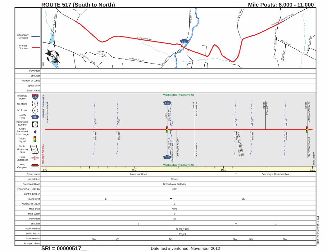
ROUTE 517 (South to North)
SRI = 00000517__
Mile Posts: 8.000 - 11.000
7893
Date last inventoried: November 2012
Page C
reate
d: J
une, 2
015
8.0 9.0 10.0 11.0
Washington Twp, Morris Co
Washington Twp, Morris Co
(8.5
5)
ST
RE
AM
(8.8
1)
ST
RE
AM
(9.4
1)
S. B
R. R
AR
ITA
N R
IVE
R
(10.1
3)
ST
RE
AM
(10.3
1)
ST
RE
AM
(10.6
9)
ST
RE
AM
(8.0
1) H
IGH
LA
ND
AV
E
W. M
ILL R
D
(9.3
7)
E. M
ILL R
D
(9.4
7) F
AIR
VIE
W A
VE
W. M
AP
LE
AV
E
(9.6
8)
E. M
AP
LE
AV
E
CA
MP
WA
SH
ING
TO
N R
D
(10.1
4)
JA
ME
S T
RA
IL
(10.4
7)
W S
PR
ING
TO
WN
RD
(10.9
4)
E S
PR
ING
TO
WN
RD
513
513
Street Name Fairmount Road Schooley`s Mountain Road
Jurisdiction County
Functional Class Urban Major Collector
Federal Aid - NHS Sy STP
Control Section
Speed Limit 45 35
Number of Lanes 2
Med. Type None
Med. Width 0
Pavement 22
Shoulder 2 1
Traffic Volume 10,722 (2012)
Traffic Sta. ID 091428
Structure No. N/A N/A N/A N/A N/A N/A
Enlarged Views
Pavement
Shoulder
Number of Lanes
Speed Limit
Street Name

Schoole
y`s
Mounta
in R
oad
Newbur
gh R
oad
Flo
ck
tow
n R
oa
d
Pheas ant Drive
Rice
Lan
e Wehr
ii Road
Harv est Lane
He
ath
La
ne
57
Prim
ary
Dire
ctio
nS
eco
nd
ary
Dire
ctio
n
22
33
689
2
Interstate
Route
US Route
NJ Route
County
Road
Interchange
Number
Grade
Separated
Interchange
Traffic
Signal
Traffic
Monitoring
Sites
Road
Underpass
Road
Overpass
WIM
AVC
VOL
Un
its in
mile
s
Primary
Direction
Secondary
Direction
287
ROUTE 517 (South to North)
SRI = 00000517__
Mile Posts: 11.000 - 14.000
7894
Date last inventoried: November 2012
Page C
reate
d: J
une, 2
015
11.0 12.0 13.0 14.0
Washington Twp, Morris Co
Washington Twp, Morris Co
(11.2
5)
ST
RE
AM
(11.9
8)
ST
RE
AM
(12.0
9)
ST
RE
AM
(12.4
9)
ST
RE
AM
(12.6
2)
ST
RE
AM
(13.1
1)
ST
RE
AM
(13.8
3)
ST
RE
AM
PLE
AS
AN
T G
RO
VE
RD
(11.8
3)
HE
ALT
H L
N
(12.0
4)
FLO
CK
TO
WN
RD
NE
WB
UR
GH
RD
(13.3
9)
OR
CH
AR
D L
A
(13.4
6)
HA
ST
ING
S D
R
(13.9
7)
Street Name Schooley`s Mountain Road
Jurisdiction County
Functional Class Urban Major Collector
Federal Aid - NHS Sy STP
Control Section
Speed Limit 35 45 40 45
Number of Lanes 2
Med. Type None
Med. Width 0
Pavement 22 36
Shoulder 1 2 4 2 0
Traffic Volume
Traffic Sta. ID
Structure No. N/A N/A N/A N/A N/A N/A N/A
Enlarged Views
Pavement
Shoulder
Number of Lanes
Speed Limit
Street Name
Hight S treet
Main
Stree
t
Wil low Grov e S treet Bi lb
y D
rive
Moore Street
Mounta in A venue
Alle
n R
oa
d
Al lamuc hy Road
East Av enue
Ne
wb
urgh
Ro
ad
Plane Street
Admira l J ohn D Bulk eley M em oria l H ighway
1s t A venue
5th
Str
ee
t
Fra
nklin
Street
7th
Str
ee
t
Warren Street
Winchester A venue
Stiger S tr eet
Mi tchel l Road
Kings
Hgw
y
Miller S
tree
t
Ridgley Str eet
Schooley` s Mountain Road
Lawrence Driv e
Ridge
Lane
Old Al lam uchy Road
Louis Lane
Reese Run Cook S treet
Ry an Way
Laurie
Ter
Se
ymoir T
er
Pin
e S
tree
t
Water S treet
Ove
rlook W
ay
Bells L
ane
4657
182
604
665
654
Prim
ary
Dire
ctio
nS
eco
nd
ary
Dire
ctio
n
22
33
689
2
Interstate
Route
US Route
NJ Route
County
Road
Interchange
Number
Grade
Separated
Interchange
Traffic
Signal
Traffic
Monitoring
Sites
Road
Underpass
Road
Overpass
WIM
AVC
VOL
Un
its in
mile
s
Primary
Direction
Secondary
Direction
287
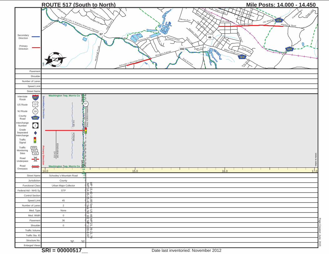
ROUTE 517 (South to North)
SRI = 00000517__
Mile Posts: 14.000 - 14.450
7895
Date last inventoried: November 2012
Page C
reate
d: J
une, 2
015
14.0 15.0 16.0 17.0
MP
15.4
2-1
5.8
5 S
ee U
S 4
6 M
P 2
1.2
6-2
1.7
0M
P 1
4.4
5-1
5.4
2 S
ee N
J 1
82 M
P 0
.00-0
.97
(14.4
2)
Washington Twp, Morris Co
(14.4
2)Washington Twp, Morris Co
(14.4
2)
Hac ket tst n,
War . C o.
(14.4
2)Hac
ket tst n,
War . C o.
(14.3
0)
ST
RE
AM
(14.4
2)
MU
SC
ON
ET
CO
NG
RIV
ER
ED
GE
VIE
W D
R
(14.1
2)
MO
RR
IS-E
SS
EX
TP
KE
(14.4
5)
57
Street Name Schooley`s Mountain Road
Jurisdiction County
Functional Class Urban Major Collector
Federal Aid - NHS Sy STP
Control Section
Speed Limit 45
Number of Lanes 2
Med. Type None
Med. Width 0
Pavement 36
Shoulder 0
Traffic Volume
Traffic Sta. ID
Structure No. N/A N/A
Enlarged Views
Pavement
Shoulder
Number of Lanes
Speed Limit
Street Name

Hight S treet
Main
Stree
t
Wil low Grov e S treet Bi lb
y D
rive
Moore Street
Mounta in A venue
Alle
n R
oa
d
Al lamuc hy Road
East Av enue
Ne
wb
urgh
Ro
ad
Plane Street
Admira l J ohn D Bulk eley M em oria l H ighway
1s t A venue
5th
Str
ee
t
Fra
nklin
Street
7th
Str
ee
t
Warren Street
Winchester A venue
Stiger S tr eet
Mi tchel l Road
Kings
Hgw
y
Miller S
tree
t
Ridgley Str eet
Schooley` s Mountain Road
Lawrence Driv e
Ridge
Lane
Old Al lam uchy Road
Louis Lane
Reese Run Cook S treet
Ry an Way
Laurie
Ter
Se
ymoir T
er
Pin
e S
tree
t
Water S treet
Ove
rlook W
ay
Bells L
ane
4657
182
604
665
654
Prim
ary
Dire
ctio
nS
eco
nd
ary
Dire
ctio
n
22
33
689
2
Interstate
Route
US Route
NJ Route
County
Road
Interchange
Number
Grade
Separated
Interchange
Traffic
Signal
Traffic
Monitoring
Sites
Road
Underpass
Road
Overpass
WIM
AVC
VOL
Un
its in
mile
s
Primary
Direction
Secondary
Direction
287
ROUTE 517 (South to North)
SRI = 00000517__
Mile Posts: 15.850 - 17.000
7895
Date last inventoried: November 2012
Page C
reate
d: J
une, 2
015
14.0 15.0 16.0 17.0
MP
15.8
5=
End C
oin
c W
ith U
S 4
6 M
P 2
1.2
6
(16.8
3)
Hackettstown Town, Warren Co
(16.8
3)Hackettstown Town, Warren Co
(16.8
3)
Indep, War. Co.
(16.8
3) Indep, War. Co.
(16.2
0)
D.L
.W.R
.R.
(16.6
0)
ST
RE
AM
MA
IN
(15.8
5)
ST
RE
ET
FR
AN
KLIN
(15.9
5)
ST
RE
ET
(16.0
5) C
OO
KS
TR
EE
T
(16.1
7) M
ILLE
R S
T
(16.2
1) 4
TH
ST
(16.2
3) 5
TH
ST
(16.3
0) 6
TH
ST
(16.3
7) 7
TH
ST
(16.4
3) O
AK
ST
PR
IVA
TE
RD
OLD
ALLA
MU
CH
Y R
D(1
6.6
5)
TO
WP
AT
H R
D
(16.8
8)
46
46
654
Street Name Hight Street Allamuchy Road
Jurisdiction Municipal County
Functional Class Urban Minor Arterial
Federal Aid - NHS Sy STP
Control Section
Speed Limit 25 35 40
Number of Lanes 2
Med. Type None
Med. Width 0
Pavement 30 28 24
Shoulder 0 4
Traffic Volume
Traffic Sta. ID
Structure No. N/A
Enlarged Views
Pavement
Shoulder
Number of Lanes
Speed Limit
Street Name

Al lamuc hy Road
Ridge
LaneM
t Ras
cal R
oad
Old Hacketstown Road
De
er
Park R
oa
d
Ove
rlook W
ay
653
Prim
ary
Dire
ctio
nS
eco
nd
ary
Dire
ctio
n
22
33
689
2
Interstate
Route
US Route
NJ Route
County
Road
Interchange
Number
Grade
Separated
Interchange
Traffic
Signal
Traffic
Monitoring
Sites
Road
Underpass
Road
Overpass
WIM
AVC
VOL
Un
its in
mile
s
Primary
Direction
Secondary
Direction
287
ROUTE 517 (South to North)
SRI = 00000517__
Mile Posts: 17.000 - 20.000
7896
Date last inventoried: November 2012
Page C
reate
d: J
une, 2
015
17.0 18.0 19.0 20.0
(17.5
5)
Independence Twp, Warren Co
(17.5
5)Independence Twp, Warren Co
(17.5
5)
Allamuchy Twp, Warren Co
(17.5
5) Allamuchy Twp, Warren Co
(19.6
5)
ST
RE
AMB
ILB
Y D
R
(17.1
0)
OLD
ALLA
MU
CH
Y D
R
(17.1
3)
OLD
BIL
BY
RD
(17.3
3)
RID
GE
LN
(17.7
9)
UN
NA
ME
D R
D
UN
NA
ME
D R
D(1
7.9
8)
LO
NE
PIN
E T
ER
(18.0
1)
DE
ER
PA
RK
RD
(18.3
1)
RID
GE
RD
(18.5
0)
CA
T S
WA
MP
RD
(18.8
0)
RU
TH
ER
FO
RD
RD
(19.2
8)
BA
LD
EA
GLE
RD
(19.6
9)
665
654 653
Street Name Allamuchy Road
Jurisdiction County
Functional Class Urban Minor Arterial
Federal Aid - NHS Sy STP
Control Section
Speed Limit 40 45
Number of Lanes 2 3 2
Med. Type None
Med. Width 0
Pavement 24 38 24
Shoulder 4 2 6 4
Traffic Volume 15,645 (2010)
Traffic Sta. ID 092120
Structure No. N/A
Enlarged Views
Pavement
Shoulder
Number of Lanes
Speed Limit
Street Name

Al lamuc hy RoadDeck er Pond Road
Stuyves ant Road
Alphano Road
John
son
bu
rg R
oa
d
Ke
nne
dy R
oad
Pu ffer R
oad
Old Hackettstown RoadFr Rt 517 Nb To I-80 E
b
§̈¦80
612
667
613 611
Prim
ary
Dire
ctio
nS
eco
nd
ary
Dire
ctio
n
22
33
689
2
Interstate
Route
US Route
NJ Route
County
Road
Interchange
Number
Grade
Separated
Interchange
Traffic
Signal
Traffic
Monitoring
Sites
Road
Underpass
Road
Overpass
WIM
AVC
VOL
Un
its in
mile
s
Primary
Direction
Secondary
Direction
287
ROUTE 517 (South to North)
SRI = 00000517__
Mile Posts: 20.000 - 23.000
7897
Date last inventoried: November 2012
Page C
reate
d: J
une, 2
015
20.0 21.0 22.0 23.0
(22.4
2)
Allamuchy Twp, Warren Co
(22.4
2)Allamuchy Twp, Warren Co
(22.4
2)
Green Twp, Sussex Co
(22.4
2) Green Twp, Sussex Co
(20.9
1)
BR
. OF
TR
OU
T B
RO
OK
(21.6
3)
RT-8
0 R
AM
P
(20.3
9)
CH
RIS
TO
PH
ER
(20.4
8)
CO
LU
MB
US
HW
Y
OLD
HA
CK
ET
TS
TO
WN
(20.6
6) R
OA
D
PU
FF
ER
(20.8
5)
RO
AD
OLD
HA
CK
ET
TS
TO
WN
(21.0
5) R
OA
D
TR
AN
QU
ILIT
Y F
AR
M L
A
(21.9
5) K
EN
NE
DY
RD
(22.8
1)
ST
UY
VE
SA
NT
RD
80
80
667667 667667 611
Street Name Allamuchy Road Decker Pond Road
Jurisdiction County
Functional Class Urban Minor Arterial Rural Minor Arterial
Federal Aid - NHS Sy STP
Control Section
Speed Limit 45 50
Number of Lanes 2 3 2
Med. Type None
Med. Width 0
Pavement 24 40 24
Shoulder 4 0 6 4
Traffic Volume 9,308 (2012)
Traffic Sta. ID 122119
Structure No. 2116165 N/A N/A
Enlarged Views
Pavement
Shoulder
Number of Lanes
Speed Limit
Street Name

Deck er Pond Road
Shore Road
Sce
nic
Driv
e
Ai rpor t R
oad
Mo
unt
ain
vie
w D
rive
Sunset Dr ive
Sunny Lane
Wh
ite
hall R
oa
d
Me
ado
w L
an
e
Park Ter
Lake
vie
w D
r iv
e
Spruce Driv e
Wh
iteh
al l Ro
ad
603
Prim
ary
Dire
ctio
nS
eco
nd
ary
Dire
ctio
n
22
33
689
2
Interstate
Route
US Route
NJ Route
County
Road
Interchange
Number
Grade
Separated
Interchange
Traffic
Signal
Traffic
Monitoring
Sites
Road
Underpass
Road
Overpass
WIM
AVC
VOL
Un
its in
mile
s
Primary
Direction
Secondary
Direction
287
ROUTE 517 (South to North)
SRI = 00000517__
Mile Posts: 23.000 - 26.000
7898
Date last inventoried: November 2012
Page C
reate
d: J
une, 2
015
23.0 24.0 25.0 26.0
Green Twp, Sussex Co
Green Twp, Sussex Co
ME
AD
OW
LN
(23.2
6)
(23.3
3) S
CE
NIC
DR
AIR
PO
RT
RD
(23.3
9)
CE
DA
R L
N
(23.6
0)
(23.6
6) O
AK
LN
(23.7
2) F
IR L
NT
ER
HU
NE
RD
(23.7
3)
(23.7
8) L
AK
E T
ER
(23.8
0) S
UN
SE
T D
R
PA
RK
TE
R
(23.9
8)
LA
KE
VIE
W R
D
(24.2
9)
MO
UN
TA
INV
IEW
DR
(24.5
3)
CO
UR
TN
EY
LN
(24.7
7)
WH
ITE
HA
LL R
D
(25.9
0)
WH
ITE
HA
LL R
D
(26.0
0)
603
Street Name Decker Pond Road Whitehall Road
Jurisdiction County
Functional Class Rural Minor Arterial
Federal Aid - NHS Sy STP
Control Section
Speed Limit 50 35 45
Number of Lanes 2
Med. Type None
Med. Width 0
Pavement 24 22
Shoulder 4 2
Traffic Volume
Traffic Sta. ID
Structure No.
Enlarged Views
Pavement
Shoulder
Number of Lanes
Speed Limit
Street Name

Main
Stree
t
Andov er Sparta Road
Tranquil ity Road
Lenape Av enue
Lenape Road
Brighton Avenue
Sussex Avenue
Elm A venue
Ballantine Way
Potter A venue
Ma
ple
Stre
et
Smith Street Prospect P lace
Hig
h Stre
et
Brandon Cour t
Ayers Circ leHig
h Stre
et
206
606
613
Prim
ary
Dire
ctio
nS
eco
nd
ary
Dire
ctio
n
22
33
689
2
Interstate
Route
US Route
NJ Route
County
Road
Interchange
Number
Grade
Separated
Interchange
Traffic
Signal
Traffic
Monitoring
Sites
Road
Underpass
Road
Overpass
WIM
AVC
VOL
Un
its in
mile
s
Primary
Direction
Secondary
Direction
287
ROUTE 517 (South to North)
SRI = 00000517__
Mile Posts: 26.000 - 27.040
7899
Date last inventoried: November 2012
Page C
reate
d: J
une, 2
015
26.0 27.0 28.0 29.0
MP
27.0
4 =
Begin
Coin
c. W
ith U
S 2
06 M
P 1
03.3
2M
P 2
7.0
4-2
7.1
2 S
ee U
S 2
06 M
P 1
03.3
2-1
03.4
2
(26.1
5)
Green, Sus. Co.
(26.1
5)Green, Sus. Co.
(26.1
5)
Andover Boro, Sussex Co
(26.1
5) Andover Boro, Sussex Co
(26.6
0)
C.R
.
WH
ITE
HA
LL R
D
(26.0
0)
HIG
H
(26.8
5)
AN
DO
VE
R-B
RIG
HT
ON
RD
ST
RE
ET
(26.9
2) W
. MA
PLE
ST
MA
PLE
ST
(26.9
9) R
AIL
RO
AD
AV
E
ST
RE
ET
(27.0
4) M
AIN
606
606 206
206
Street Name Tranquility Road Brighton Avenue
Jurisdiction County
Functional Class Urban Minor Arterial
Federal Aid - NHS Sy STP
Control Section
Speed Limit 45 30
Number of Lanes 2
Med. Type None
Med. Width 0
Pavement 22
Shoulder 2
Traffic Volume
Traffic Sta. ID
Structure No. N/A
Enlarged Views
Pavement
Shoulder
Number of Lanes
Speed Limit
Street Name

Main
Stree
t
Andov er Sparta Road
Tranquil ity Road
Lenape Av enue
Lenape Road
Brighton Avenue
Sussex Avenue
Elm A venue
Ballantine Way
Potter A venue
Ma
ple
Stre
et
Smith Street Prospect P lace
Hig
h Stre
et
Brandon Cour t
Ayers Circ leHig
h Stre
et
206
606
613
Prim
ary
Dire
ctio
nS
eco
nd
ary
Dire
ctio
n
22
33
689
2
Interstate
Route
US Route
NJ Route
County
Road
Interchange
Number
Grade
Separated
Interchange
Traffic
Signal
Traffic
Monitoring
Sites
Road
Underpass
Road
Overpass
WIM
AVC
VOL
Un
its in
mile
s
Primary
Direction
Secondary
Direction
287
ROUTE 517 (South to North)
SRI = 00000517__
Mile Posts: 27.120 - 29.000
7899
Date last inventoried: November 2012
Page C
reate
d: J
une, 2
015
26.0 27.0 28.0 29.0
MP
27.1
2 =
End C
oin
c W
ith U
S 2
06 M
P 1
03.4
2
(27.9
9)
Andover Boro, Sussex Co
(27.9
9)Andover Boro, Sussex Co
(27.9
9)
Andover Twp, Sussex Co
(27.9
9) Andover Twp, Sussex Co
(27.2
2)
ST
RE
AM
(27.8
7)
ST
RE
AM
(28.6
5)
LA
KE
LE
NA
PE
(27.1
2)
(27.1
7) G
RIS
T M
ILL L
N
AN
DO
VE
R M
OH
AW
K R
D
(27.2
9)
OLD
CR
EA
ME
RY
RD
(27.7
5)
AY
ER
S C
IR
(28.1
8)
(28.1
9) H
ILLC
RE
ST
AV
ED
ELA
WA
RE
VIE
W
(28.2
3)
SU
SS
EX
(28.4
3)
AV
E
(28.4
8) H
ILLC
RE
ST
AV
E
(28.5
5) L
EN
AP
E A
VE
(28.6
9) E
LM
AV
E
(28.7
3) P
OT
TE
R A
VE
(28.7
8) P
EN
N A
VE
(28.8
7) O
VE
RLO
OK
RD
206
206 613
Street Name Lenape Road Andover Sparta Road
Jurisdiction County
Functional Class Urban Minor Arterial
Federal Aid - NHS Sy STP
Control Section
Speed Limit NOT POSTED 35 45
Number of Lanes 2
Med. Type None
Med. Width 0
Pavement 22
Shoulder 2
Traffic Volume 3,038 (2011)
Traffic Sta. ID 1-4-405
Structure No. N/A N/A N/A
Enlarged Views
Pavement
Shoulder
Number of Lanes
Speed Limit
Street Name

Andov er Sparta Road
Kilro
y R
oa
d
Payne R
oad
Liber ty Tra il
Cu
rren
t Ro
ad
Pero
na
Road
Kim
be
rly C
ou
rt
West
gate D
rive
Kathleen
Carria
ge H
ouse R
oad
Overlook Road
Elm A venue
Valley VIew Trail
Marlene Lane
Penn A venue
Ei leens Way
Stra
tton C
our t
Prim
ary
Dire
ctio
nS
eco
nd
ary
Dire
ctio
n
22
33
689
2
Interstate
Route
US Route
NJ Route
County
Road
Interchange
Number
Grade
Separated
Interchange
Traffic
Signal
Traffic
Monitoring
Sites
Road
Underpass
Road
Overpass
WIM
AVC
VOL
Un
its in
mile
s
Primary
Direction
Secondary
Direction
287
ROUTE 517 (South to North)
SRI = 00000517__
Mile Posts: 29.000 - 32.000
7900
Date last inventoried: November 2012
Page C
reate
d: J
une, 2
015
29.0 30.0 31.0 32.0
(31.1
1)
Andover Twp, Sussex Co(3
1.1
1)Andover Twp, Sussex Co
(31.1
1)
Sparta Twp, Sussex Co(3
1.1
1) Sparta Twp, Sussex Co
VA
LLE
YF
IELD
RD
(29.0
5)
BR
IAR
PA
TC
H R
D
(29.3
1)
MA
RLE
NE
LN
(29.7
6)
KIL
RO
Y R
D
(29.8
5)
HID
DE
N V
ALLE
Y R
D
(29.9
2)
SK
YT
OP
RD
(30.0
7)
PA
YN
E R
D
(30.4
7)
LIB
ER
TY
TR
AIL
(30.5
2)
CU
RR
EN
T D
R
(31.0
2)
(31.1
0) P
ER
ON
A R
D
WE
ST
GA
TE
DR
(31.4
2)
FA
ITH
AN
N W
AY
(31.6
3)
(31.8
2) T
O S
PA
RTA
ALP
INE
SC
HO
OL
KIM
BE
RLY
CT
(31.8
6)
Street Name Andover Sparta Road
Jurisdiction County
Functional Class Urban Minor Arterial
Federal Aid - NHS Sy STP
Control Section
Speed Limit 45 40
Number of Lanes 2
Med. Type None
Med. Width 0
Pavement 22
Shoulder 2
Traffic Volume 2,804 (2012)
Traffic Sta. ID 1-4-412
Structure No.
Enlarged Views
Pavement
Shoulder
Number of Lanes
Speed Limit
Street Name

NJ
15
Newton S par ta Road
Main S tr eet
Andov er Sparta Road
Sta
tio
n R
oa
d
Glen R
oad
Sp
arta A
ven
ue
Kn
oll R
oa
d
La
faye
tte R
oa
d
Sparta Road
Surre
y Lane
Ce
lia D
rive
Nea lley D
rive
NJ
15
18115
620
Prim
ary
Dire
ctio
nS
eco
nd
ary
Dire
ctio
n
22
33
689
2
Interstate
Route
US Route
NJ Route
County
Road
Interchange
Number
Grade
Separated
Interchange
Traffic
Signal
Traffic
Monitoring
Sites
Road
Underpass
Road
Overpass
WIM
AVC
VOL
Un
its in
mile
s
Primary
Direction
Secondary
Direction
287
ROUTE 517 (South to North)
SRI = 00000517__
Mile Posts: 32.000 - 35.000
7901
Date last inventoried: November 2012
Page C
reate
d: J
une, 2
015
32.0 33.0 34.0 35.0
Sparta Twp, Sussex Co
Sparta Twp, Sussex Co
CO
VE
NT
RY
LN
(32.0
9)
STA
CE
Y C
T
(32.1
5)
TIM
BE
RLIN
E D
R
(32.2
2)
NE
WT
ON
SP
AR
TA
RD
(32.7
1)
S. S
HO
RE
TE
R
(32.8
0)
(32.9
5) P
INE
TE
R
(33.0
0) N
. SH
OR
E T
RA
IL
ME
MO
RY
LN
(33.0
6)
SU
RR
EY
LN
(33.2
4)
WA
GO
N W
HE
EL R
D
(33.4
3)
FO
X R
UN
RD
(33.5
2)
CA
RR
IAG
E L
N
(33.6
8)
CA
RR
IAG
E L
N
(33.8
1)
TO
SU
SS
EX
SP
OR
TS
CT
R
(33.8
3)
KN
OLL R
D
(33.9
8)
LA
FA
YE
TT
E R
D
(34.0
5)
SP
AR
TA
AV
E
FR
OM
RT-1
5
(34.5
8)
TO
RT-1
5
(34.6
8)
(34.7
9) T
O R
T-1
5F
RO
M R
T-1
5
(34.8
7) S
TA
TIO
NR
OA
D
616 181
181
15
15
Street Name Andover Sparta Road Sparta Road Newton Sparta Road
Jurisdiction County
Functional Class Urban Minor Arterial
Federal Aid - NHS Sy STP
Control Section
Speed Limit 40 35 45 50 45
Number of Lanes 2
Med. Type None
Med. Width 0
Pavement 22 34 30
Shoulder 2 4 2 8
Traffic Volume 6,607 (2014) 23,465 (2014) 20,627 (2011)
Traffic Sta. ID 141901 141902 1-6-224
Structure No. 1913154,155 N/A
Enlarged Views
Pavement
Shoulder
Number of Lanes
Speed Limit
Street Name
Main S tr eet
Ogdensburg Road
Newton S par ta Road
Madis on Driv
e
Wm
ou
nta
in R
oa
d
Gle
n B
roo
k R
oa
d
Sta
tion
Ro
ad
Adams Driv
e
Old Cedar Drive
Hol land Ci rce
Jeffers
on Terr
Bro
oks
Fla
t Ro
ad
Ric
ha
rdsv
il le R
oa
d
Wa
shin
gton
Ro
ad
Pvt A Bettino Dr ive
Gra
nt T
er
Sh
aro
n D
rive
Ric
ha
rds S
tree
t
Pvt C Wi ll is Dr iv e
Prim
ary
Dire
ctio
nS
eco
nd
ary
Dire
ctio
n
22
33
689
2
Interstate
Route
US Route
NJ Route
County
Road
Interchange
Number
Grade
Separated
Interchange
Traffic
Signal
Traffic
Monitoring
Sites
Road
Underpass
Road
Overpass
WIM
AVC
VOL
Un
its in
mile
s
Primary
Direction
Secondary
Direction
287
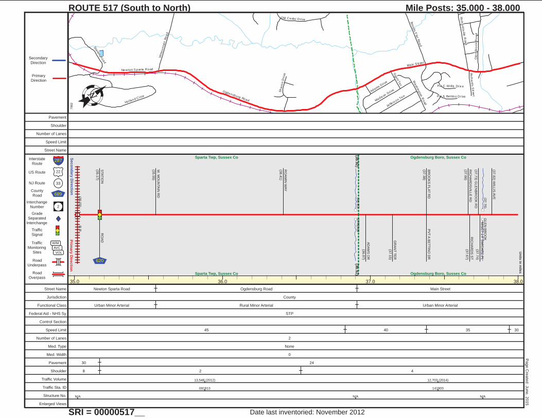
ROUTE 517 (South to North)
SRI = 00000517__
Mile Posts: 35.000 - 38.000
7902
Date last inventoried: November 2012
Page C
reate
d: J
une, 2
015
35.0 36.0 37.0 38.0
(36.9
2)
Sparta Twp, Sussex Co
(36.9
2)Sparta Twp, Sussex Co
(36.9
2)
Ogdensburg Boro, Sussex Co
(36.9
2) Ogdensburg Boro, Sussex Co
(36.9
0)
ST
RE
AM
(37.7
6)
GLE
N B
RO
OK
(35.0
2)
R.R
.
STA
TIO
N
(35.1
7)
RO
AD
W. M
OU
NTA
IN R
D
(35.5
5)
RO
AM
IN W
AY
(36.4
1)
AD
AM
S D
R
(36.9
7)
GR
AN
T T
ER
(37.1
5)
BR
OO
KS
FLA
T R
D
(37.3
8)
PV
T A
BE
TT
INO
DR
RIC
HA
RD
SV
ILLE
RD
(37.6
6)
RIC
HA
RD
S S
T
(37.6
7)
(37.7
3) G
LE
NB
RO
OK
RD
M/S
GT
J F
SW
ICA
RZ
PL
(37.7
4)
(37.8
2) W
ILLIS
AV
E
620
Street Name Newton Sparta Road Ogdensburg Road Main Street
Jurisdiction County
Functional Class Urban Minor Arterial Rural Minor Arterial Urban Minor Arterial
Federal Aid - NHS Sy STP
Control Section
Speed Limit 45 40 35 30
Number of Lanes 2
Med. Type None
Med. Width 0
Pavement 30 24
Shoulder 8 2 4
Traffic Volume 13,548 (2012) 12,703 (2014)
Traffic Sta. ID 091913 141903
Structure No. N/A N/A N/A
Enlarged Views
Pavement
Shoulder
Number of Lanes
Speed Limit
Street Name

NJ 23
Munsonhurs t Road
Main S tr eet
Ke
nne
dy
Ave
nue
Ste
rlin
gh
i ll
Ro
ad
Fox Hi l l Drive
North Clark Street
Ogden Way
Munso
nhurs
t Road
23
631
Prim
ary
Dire
ctio
nS
eco
nd
ary
Dire
ctio
n
22
33
689
2
Interstate
Route
US Route
NJ Route
County
Road
Interchange
Number
Grade
Separated
Interchange
Traffic
Signal
Traffic
Monitoring
Sites
Road
Underpass
Road
Overpass
WIM
AVC
VOL
Un
its in
mile
s
Primary
Direction
Secondary
Direction
287
ROUTE 517 (South to North)
SRI = 00000517__
Mile Posts: 38.000 - 39.840
7903
Date last inventoried: November 2012
Page C
reate
d: J
une, 2
015
38.0 39.0 40.0 41.0
MP
39.8
4 =
Begin
Coin
c. W
ith N
J 2
3 M
P 3
4.3
5M
P 3
9.8
4-4
2.5
4 S
ee N
J 2
3 M
P 3
1.6
8-3
4.3
5
(38.6
5)
Ogdensburg Boro, Sussex Co
(38.6
5)Ogdensburg Boro, Sussex Co
(38.6
5)
Franklin Boro, Sussex Co
(38.6
5) Franklin Boro, Sussex Co
HIG
HLA
ND
AV
E
(38.1
3)
PA
SS
AIC
AV
E
(38.1
5)
(38.1
8) K
EN
NE
DY
AV
E
(38.2
2) E
DIS
ON
AV
E
(38.2
7) C
LA
RK
ST
(38.2
9) S
PR
ING
ST
(38.3
5) O
GD
EN
WA
Y
FIR
E H
OU
SE
LA
(38.3
9)
FO
X H
ILL D
R
(38.6
0)
SK
Y V
IEW
DR
(39.6
4)
MU
NS
ON
HU
RS
T R
D
(39.7
6)
(39.8
4)
23
23
Street Name Main Street Munsonhurst Road
Jurisdiction County
Functional Class Urban Minor Arterial
Federal Aid - NHS Sy STP
Control Section
Speed Limit 30 45
Number of Lanes 2
Med. Type None
Med. Width 0
Pavement 24
Shoulder 4 2
Traffic Volume
Traffic Sta. ID
Structure No.
Enlarged Views
Pavement
Shoulder
Number of Lanes
Speed Limit
Street Name
NJ
23
Scott Road
Rudevi lle Road
Quar ry Road
Mulb
erry S
treet
Mo
unta
in Ro
ad
Hi llsi
de D
rive
Limek iln Road
Exete
r Lan
e
Ca
mpb
ell D
rive
Sta
te Stre
et
23
Prim
ary
Dire
ctio
nS
eco
nd
ary
Dire
ctio
n
22
33
689
2
Interstate
Route
US Route
NJ Route
County
Road
Interchange
Number
Grade
Separated
Interchange
Traffic
Signal
Traffic
Monitoring
Sites
Road
Underpass
Road
Overpass
WIM
AVC
VOL
Un
its in
mile
s
Primary
Direction
Secondary
Direction
287
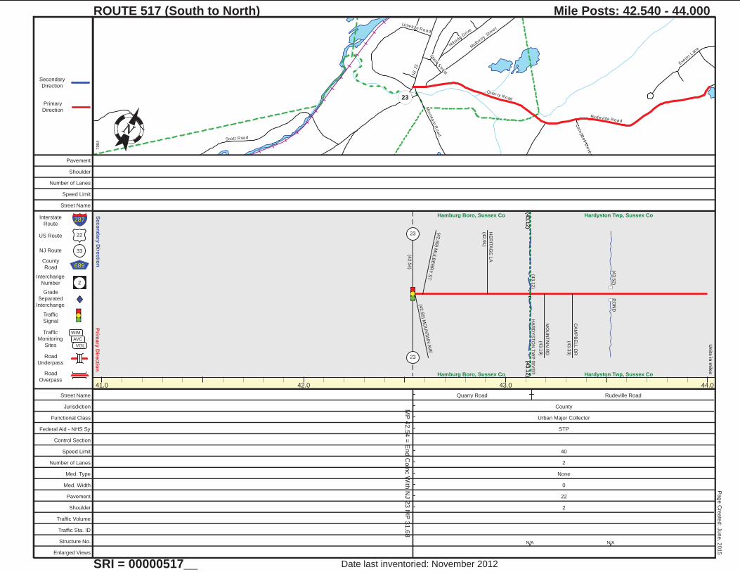
ROUTE 517 (South to North)
SRI = 00000517__
Mile Posts: 42.540 - 44.000
7904
Date last inventoried: November 2012
Page C
reate
d: J
une, 2
015
41.0 42.0 43.0 44.0
MP
42.5
4 =
End C
oin
c W
ith N
J 2
3 M
P 3
1.6
8
(43.1
2)
Hamburg Boro, Sussex Co(4
3.1
2)Hamburg Boro, Sussex Co
(43.1
2)
Hardyston Twp, Sussex Co(4
3.1
2) Hardyston Twp, Sussex Co
(43.1
2)
HA
RD
YS
TO
N T
WP
RIV
ER
(43.5
2)
PO
ND
(42.5
4)
(42.5
5) M
OU
NTA
IN A
VE
(42.5
9) M
ULB
ER
RY
ST
HE
RIT
AG
E L
A
(42.9
1)
MO
UN
TA
IN R
D
(43.1
9)
CA
MP
BE
LL D
R
(43.3
3)
23
23
Street Name Quarry Road Rudeville Road
Jurisdiction County
Functional Class Urban Major Collector
Federal Aid - NHS Sy STP
Control Section
Speed Limit 40
Number of Lanes 2
Med. Type None
Med. Width 0
Pavement 22
Shoulder 2
Traffic Volume
Traffic Sta. ID
Structure No. N/A N/A
Enlarged Views
Pavement
Shoulder
Number of Lanes
Speed Limit
Street Name
Rudevi lle Road
Exeter Lane
Old
Qu
arr
y R
oa
d
Old
Rude
tow
n R
oad
Ca
mpb
ell
Dri
ve
Andrea
Esto Lane
94
Prim
ary
Dire
ctio
nS
eco
nd
ary
Dire
ctio
n
22
33
689
2
Interstate
Route
US Route
NJ Route
County
Road
Interchange
Number
Grade
Separated
Interchange
Traffic
Signal
Traffic
Monitoring
Sites
Road
Underpass
Road
Overpass
WIM
AVC
VOL
Un
its in
mile
s
Primary
Direction
Secondary
Direction
287
ROUTE 517 (South to North)
SRI = 00000517__
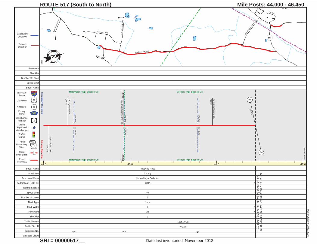
Mile Posts: 44.000 - 46.450
7905
Date last inventoried: November 2012
Page C
reate
d: J
une, 2
015
44.0 45.0 46.0 47.0
MP
46.4
5 =
Begin
Coin
c. W
ith N
J 9
4 M
P 3
8.2
3M
P 4
6.4
5-4
6.8
4 S
ee N
J 9
4 M
P 3
8.2
3-3
8.6
2
(44.9
3)
Hardyston Twp, Sussex Co
(44.9
3)Hardyston Twp, Sussex Co
(44.9
3)
Vernon Twp, Sussex Co
(44.9
3) Vernon Twp, Sussex Co
(44.3
5)
ST
RE
AM
(44.9
3)
ST
RE
AM
(45.7
8)
ST
RE
AM
SA
ND
PO
ND
RD
(44.0
6)
OLD
QU
AR
RY
RD
(44.2
8)
(44.9
2) C
RY
STA
L S
PR
. RD
OLD
RU
DE
TO
WN
RD
(45.9
5)
(46.4
5)
94
94
Street Name Rudeville Road
Jurisdiction County
Functional Class Urban Major Collector
Federal Aid - NHS Sy STP
Control Section
Speed Limit 40
Number of Lanes 2
Med. Type None
Med. Width 0
Pavement 22
Shoulder 2
Traffic Volume 4,395 (2012)
Traffic Sta. ID 091915
Structure No. N/A N/A N/A
Enlarged Views
Pavement
Shoulder
Number of Lanes
Speed Limit
Street Name

Rudevi lle Road
Exeter Lane
Old
Qu
arr
y R
oa
d
Old
Rude
tow
n R
oad
Ca
mpb
ell
Dri
ve
Andrea
Esto Lane
94
Prim
ary
Dire
ctio
nS
eco
nd
ary
Dire
ctio
n
22
33
689
2
Interstate
Route
US Route
NJ Route
County
Road
Interchange
Number
Grade
Separated
Interchange
Traffic
Signal
Traffic
Monitoring
Sites
Road
Underpass
Road
Overpass
WIM
AVC
VOL
Un
its in
mile
s
Primary
Direction
Secondary
Direction
287
ROUTE 517 (South to North)
SRI = 00000517__
Mile Posts: 46.840 - 47.000
7905
Date last inventoried: November 2012
Page C
reate
d: J
une, 2
015
44.0 45.0 46.0 47.0
MP
46.8
4 =
End C
oin
c W
ith N
J 9
4 M
P 3
8.6
2
Vernon, Sus. Co.
Vernon, Sus. Co.
(46.8
4)
94
Street Name Mcafee Glenwood Road
Jurisdiction County
Functional Class Urban Major Collector
Federal Aid - NHS Sy STP
Control Section
Speed Limit 35
Number of Lanes 2
Med. Type None
Med. Width 0
Pavement 22
Shoulder 2
Traffic Volume
Traffic Sta. ID
Structure No.
Enlarged Views
Pavement
Shoulder
Number of Lanes
Speed Limit
Street Name

Mcafee Glenwood Road
Dr ew Road
Ma
cpe
ek R
oad
Basswood Dr iv e
Ed
sa
ll D
riv
e
Linco ln Av enue
Palamino T
rail
Ind ian Tra il
Cheokee T ra il
641
Prim
ary
Dire
ctio
nS
eco
nd
ary
Dire
ctio
n
22
33
689
2
Interstate
Route
US Route
NJ Route
County
Road
Interchange
Number
Grade
Separated
Interchange
Traffic
Signal
Traffic
Monitoring
Sites
Road
Underpass
Road
Overpass
WIM
AVC
VOL
Un
its in
mile
s
Primary
Direction
Secondary
Direction
287
ROUTE 517 (South to North)
SRI = 00000517__
Mile Posts: 47.000 - 50.000
7906
Date last inventoried: November 2012
Page C
reate
d: J
une, 2
015
47.0 48.0 49.0 50.0
Vernon Twp, Sussex Co
Vernon Twp, Sussex Co
CA
RR
LA
(47.5
7)
(47.6
4) C
ED
AR
RID
GE
RD
(47.7
2) P
AR
RIS
H D
R
(47.7
9) W
AS
HIN
GT
ON
ST
LA
KE
PO
CH
UN
G R
D
(48.2
6)
MacP
EE
K R
D
(48.4
5)
ED
SA
LL D
R
(48.6
8) D
RE
W M
T. R
D
(49.2
6)
DR
EW
RD
FO
XC
RA
FT
RD
(49.4
8)
BLA
CK
WA
LN
UT
MT. R
D
(49.8
0)
641
Street Name Mcafee Glenwood Road
Jurisdiction County
Functional Class Urban Major Collector
Federal Aid - NHS Sy STP
Control Section
Speed Limit 35 40
Number of Lanes 2
Med. Type None
Med. Width 0
Pavement 22
Shoulder 2
Traffic Volume 4,204 (2012) 5,522 (2012)
Traffic Sta. ID 121991 091916
Structure No.
Enlarged Views
Pavement
Shoulder
Number of Lanes
Speed Limit
Street Name
Sandhi ll Road
Samm is Road
Sand Hi ll Road
Mca
fee
Gle
nw
ood
Roa
d
Lounds berr y Road
Ma
ple
Gra
ng
e Ro
ad
Ro l ling Hil Road
Ho
lde
rne
ss
Driv
e
644
Prim
ary
Dire
ctio
nS
eco
nd
ary
Dire
ctio
n
22
33
689
2
Interstate
Route
US Route
NJ Route
County
Road
Interchange
Number
Grade
Separated
Interchange
Traffic
Signal
Traffic
Monitoring
Sites
Road
Underpass
Road
Overpass
WIM
AVC
VOL
Un
its in
mile
s
Primary
Direction
Secondary
Direction
287
ROUTE 517 (South to North)
SRI = 00000517__
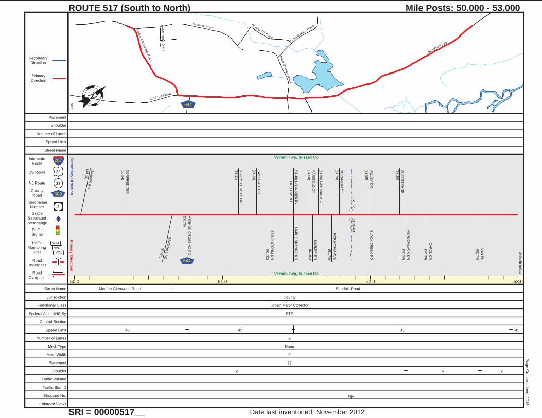
Mile Posts: 50.000 - 53.000
7907
Date last inventoried: November 2012
Page C
reate
d: J
une, 2
015
50.0 51.0 52.0 53.0
Vernon Twp, Sussex Co
Vernon Twp, Sussex Co
(51.8
7)
ST
RE
AM
SA
MM
IS R
D(5
0.0
4)
DO
RF
RE
D T
ER
(50.3
4)
SA
ND
HIL
L R
D(5
0.6
6)
VE
RN
ON
CR
OS
SIN
G R
D
(50.7
6)
ST
OR
M E
STA
TE
S D
R
(51.1
1)
EA
ST
GA
TE
DR
(51.2
3)
SE
ELY
ST
OR
M D
R
(51.3
2)
(51.4
8) L
OU
NS
BE
RR
YM
AP
LE
GR
AN
GE
RD
HO
LLO
W R
D
MA
RIG
OLD
CT
(51.6
0)
MA
SK
ER
RD
(51.6
1)
(51.6
5) G
ER
AN
IUM
CT
FO
RS
YT
HIA
AV
E
(51.7
4)
GE
RA
NIU
M C
T
(51.7
9)
VA
LLE
Y D
R
(51.9
9)
BLA
CK
CR
EE
K R
D
VLIE
TS
TR
A D
R
(52.2
0)
ME
AD
OW
LA
CK
DR
(52.2
4)
CA
RO
L D
R
(52.3
9)
AN
N P
L
(52.7
4)
644
Street Name Mcafee Glenwood Road Sandhill Road
Jurisdiction County
Functional Class Urban Major Collector
Federal Aid - NHS Sy STP
Control Section
Speed Limit 40 45 35 45
Number of Lanes 2
Med. Type None
Med. Width 0
Pavement 22
Shoulder 2 6 2
Traffic Volume
Traffic Sta. ID
Structure No. N/A
Enlarged Views
Pavement
Shoulder
Number of Lanes
Speed Limit
Street Name

Sandhi ll Road
Slay ton Place
Colon ial C ir
Gle
nw
oo
d R
oa
d Pochuck M t Driv e
565
Prim
ary
Dire
ctio
nS
eco
nd
ary
Dire
ctio
n
22
33
689
2
Interstate
Route
US Route
NJ Route
County
Road
Interchange
Number
Grade
Separated
Interchange
Traffic
Signal
Traffic
Monitoring
Sites
Road
Underpass
Road
Overpass
WIM
AVC
VOL
Un
its in
mile
s
Primary
Direction
Secondary
Direction
287
ROUTE 517 (South to North)
SRI = 00000517__
Mile Posts: 53.000 - 53.860
7908
Date last inventoried: November 2012
Page C
reate
d: J
une, 2
015
53.0 54.0 55.0 56.0
End R
t. 517 M
P=
53.8
6N
ew
York
Sta
te L
ine
Vernon Twp, Sussex Co
Vernon Twp, Sussex Co
(53.4
5)
ST
RE
AM
(53.4
3) G
LE
NW
OO
D R
D
(53.4
9) S
HIA
WA
SS
E D
R
565
Street Name Sandhill Road
Jurisdiction County
Functional Class Urban Major Collector Rural Major Collector
Federal Aid - NHS Sy STP
Control Section
Speed Limit 45
Number of Lanes 2
Med. Type None
Med. Width 0
Pavement 22
Shoulder 2
Traffic Volume 2,608 (2014)
Traffic Sta. ID 141904
Structure No. N/A
Enlarged Views
Pavement
Shoulder
Number of Lanes
Speed Limit
Street Name