roseway streetscape concept plan, complete
DESCRIPTION
The Roseway-Sandy Streetscape Concept Plan advances the community’s vision for Sandy Boulevard from 68th to 80th Avenues as their Main Street. Intersect Planning prepared the Concept Plan for the Roseway Neighborhood Association - creating ideas for how future transportation investments may improve the quality, character, and safety of Sandy Boulevard for all members of the community. The document is in 4 parts.TRANSCRIPT

June 6, 2005June 6, 2005 Intersect PlanningIntersect Planning

Roseway-Sandy Streetscape Concept Plan
Prepared by: Intersect Planning
Matt Lasky
Mike Tresidder Jay Renkens
Morgan Shook
Prepared For: Roseway Neighborhood Association - Land Use Committee
Sean Batty
Chris Caruso Steven Eggleston
Kerry Graves Alli Schilf
Lauren Schmitt
Technical Advisory Committee:
Debbie Bischoff
Portland Bureau of Planning Jeanne Harrison
Portland Office of Transportation Kim Ellis
Metro Tom Kloster
Metro
Portland State University - Master of Urban and Regional Planning Program
Planning Workshop provides graduate students with a professional planning experience both in the public and private sector. Student teams develop consulting contracts with clients for planning
services that address local and regional issues and the students’ personal and professional interests. The Workshop provides experience in planning for constructive social and environmental change,
while considering the planner’s ethical responsibility to serve the public interest.

ii
Acknowledgements Intersect Planning would like to thank the following people for their support and help in the development of the Roseway-Sandy Streetscape Concept Plan. From the Roseway neighborhood: Sean Batty, Chris Caruso, Steven Eggleston, Kerry Graves, Bonnie Ladoe, Alli Schilf, Lauren Schmitt, and Annie’s Donuts. From various agencies in the Portland region: Debbie Bischoff, John Gillam, Jeanne Harrison, Kim Ellis, and Tom Kloster. From Portland State University: Dr. Sy Adler, Dr. Deborah Howe, Dr. Connie Ozawa, and the Urban Studies and Planning 2005 Workshop Class. A special thank you to Dep Shook.

iii
Executive Summary The Roseway-Sandy Streetscape Concept Plan advances the community’s vision for Sandy Boulevard from 68th to 80th Avenues as their Main Street. Intersect Planning prepared the Concept Plan for the Roseway Neighborhood Association - creating ideas for how future transportation investments may improve the quality, character, and safety of Sandy Boulevard for all members of the community. Three analyses were completed in preparation of the Concept Plan.
1. Existing Conditions Analysis examines the physical transportation environment along Sandy Boulevard in the study corridor.
2. Community Visions and Values Analysis includes summaries of the Roseway Neighborhood Association Vision Plan, Roseway-Sandy Main Street business surveys, and key informant interviews.
3. Portland Main Street Case Study Analysis and Main Street Transportation Solutions Toolbox reviews other Portland area main street plans and presents transportation improvements identified in transportation planning literature.
Analyses revealed several reoccurring themes regarding Roseway-Sandy’s future as a main street. Residents and businesses identified problems with the pedestrian and auto environments. Field observations revealed wide streets that allow motorists to travel at speeds higher than the posted limit and create long crossing distances for pedestrians. Many intersections along Sandy Boulevard permit motorists to make high-speed right turns onto residential streets. Residents and business owners envision a lively pedestrian-oriented commercial main street with safer and more frequent pedestrian crossings, street trees, slower traffic speeds, better lighting for nighttime safety, and the retention of on-street parking. Existing conditions analyses in the study area revealed a lack of marked crosswalks, street trees, benches, trashcans, and lighting. The larger Streetscape Concept Plan for the Roseway-Sandy Main Street addresses high traffic speeds and a poor pedestrian environment with lane reductions, planted medians and left-hand turning bays, and several new pedestrian amenities. Five focus areas highlight specific treatments including: curb extensions; pedestrian amenities; street trees; bulb outs; bike lanes; pavement markings; a shared bike and bus lane; and driveway consolidation.

iv

v
Table of Contents Page Section I. Roseway-Sandy Streetscape Concept Plan 1
1.1 Streetscape Concept Plan 4
1.2 Next Steps 17
Section II. Planning Overview 21
2.1 Background 23
2.2 Problem Statement 25
2.3 Planning Intentions 26
Section III. Existing Conditions Analysis 27
3.1 Street Classifications 29
3.2 Physical Street Features & Streetscape Edge Activity 33
3.3 Auto Volumes, Speeds & Accidents 45
3.4 Pedestrian Crossing Gaps 50
3.5 Transit Ridership 51
3.6 Zoning 54
Section IV. Community Visions and Values Analysis 57
4.1 Roseway Neighborhood Vision Plan Summary 59
4.2 Sandy Boulevard Business Survey Summary 63
4.3 Key Informant Interview Summary 68
Section V. Portland Main Street Case Study Analysis and
Main Street Solutions Toolbox
75
5.1 Portland Main Street Case Study Analysis 77
5.2 Main Street Solutions Toolbox 80
Appendices
A. Main Street Transportation Solutions Toolbox 81
B. Business Survey Instrument 95
C. Key Informant Interview Instrument 99

vi
Roseway-Sandy Streetscape Concept Plan 1
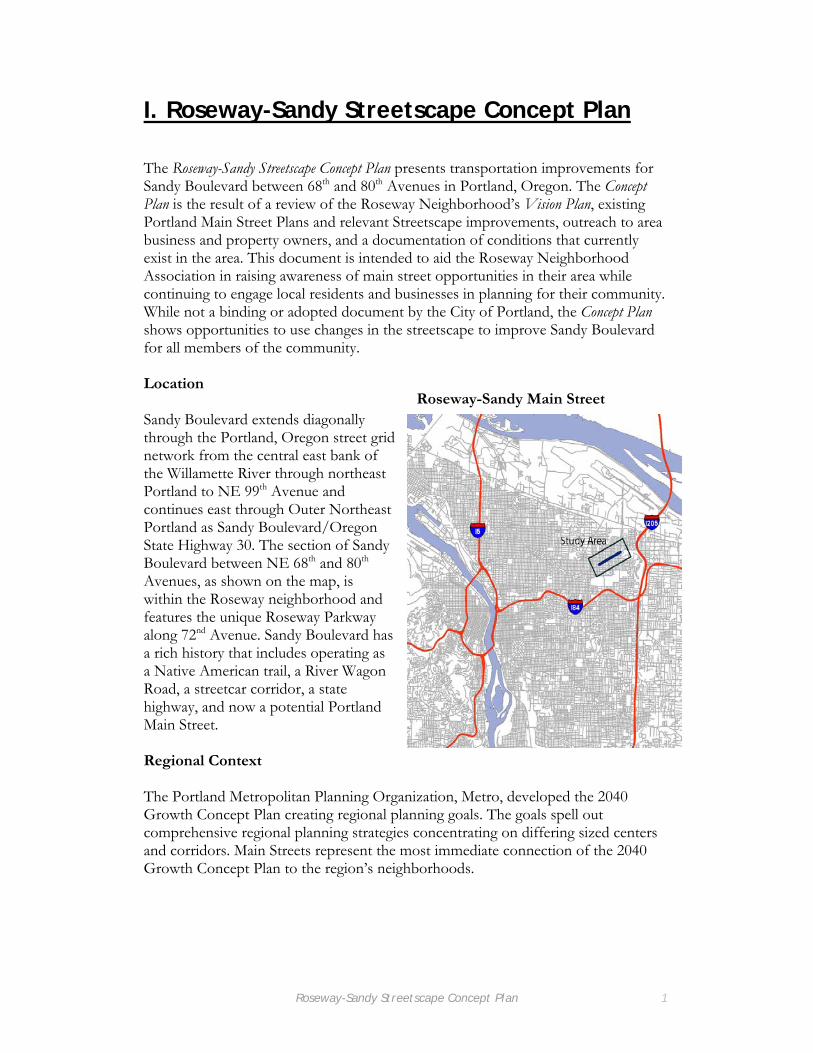
I. Roseway-Sandy Streetscape Concept Plan The Roseway-Sandy Streetscape Concept Plan presents transportation improvements for Sandy Boulevard between 68th and 80th Avenues in Portland, Oregon. The Concept Plan is the result of a review of the Roseway Neighborhood’s Vision Plan, existing Portland Main Street Plans and relevant Streetscape improvements, outreach to area business and property owners, and a documentation of conditions that currently exist in the area. This document is intended to aid the Roseway Neighborhood Association in raising awareness of main street opportunities in their area while continuing to engage local residents and businesses in planning for their community. While not a binding or adopted document by the City of Portland, the Concept Plan shows opportunities to use changes in the streetscape to improve Sandy Boulevard for all members of the community. Location Sandy Boulevard extends diagonally through the Portland, Oregon street grid network from the central east bank of the Willamette River through northeast Portland to NE 99th Avenue and continues east through Outer Northeast Portland as Sandy Boulevard/Oregon State Highway 30. The section of Sandy Boulevard between NE 68th and 80th Avenues, as shown on the map, is within the Roseway neighborhood and features the unique Roseway Parkway along 72nd Avenue. Sandy Boulevard has a rich history that includes operating as a Native American trail, a River Wagon Road, a streetcar corridor, a state highway, and now a potential Portland Main Street. Regional Context The Portland Metropolitan Planning Organization, Metro, developed the 2040 Growth Concept Plan creating regional planning goals. The goals spell out comprehensive regional planning strategies concentrating on differing sized centers and corridors. Main Streets represent the most immediate connection of the 2040 Growth Concept Plan to the region’s neighborhoods.
Roseway-Sandy Main Street

Roseway-Sandy Streetscape Concept Plan 2
Main streets are areas with retail shopping, personal services, and entertainment primarily serving the surrounding neighborhood. There are many benefits to these areas, for example residents living near main streets are able to combine multiple trips into one due to the close proximity of services. With streetscape improvements, main streets also provide a better walking environment, easier access to transit, and a better environment for small businesses. Using the Concept Plan The Concept Plan shows an overall view of transportation improvements to the Sandy Boulevard from NE 68th to 80th Avenue. Following the entire Streetscape Concept Plan are five focus areas on the Main Street showing the intersections of Sandy Boulevard and 69th, 72nd, 74th, 77th, and 79th Avenues. The areas highlight different proposed transportation and streetscape enhancements that respond to concerns raised by area residents, businesses, and current conditions identified in this planning process. Each focus area includes background information, existing conditions, a detailed map of the improvements, and reasons why the proposed developments are appropriate. The numbers on the detailed map refer to the same numbered descriptions on existing conditions and recommendation explanation. Words italicized in the Concept Plan are described further in the Main Street Transportation Solutions Toolbox in Appendix A.

12
3NE Fremont St
NE Fremont St
NE Fremont St
NE Fremont St
NE 72nd AveNE 72nd AveNE 68th AveNE 68th Ave NE 69th AveNE 69th Ave NE 70th AveNE 70th Ave NE 71st AveNE 71st Ave NE 73rd AveNE 73rd Ave
[
Roseway Sandy Streetscape Plan
4

5
Legend
1
Street tree
Landscaped median
Marked Crosswalk
Focus Areas
Bike parking
Bus shelter
Pedestrian-scalelighting
Trash can
Street furniture
74th74th NE 75th AveNE 75th Ave NE 76th AveNE 76th Ave NE 77th AveNE 77th Ave NE 78th AveNE 78th Ave NE 79th AveNE 79th Ave NE 80th AveNE 80th Ave
NE Fremont St
NE Fremont St
NE Beech St
NE Beech St
NE Failing St
NE Failing St
45

1. Sandy Blvd/69th/Safeway
Background
Existing Conditions
1. Two lanes in both the east and westbound directions, along with unmarked
on-street parking that is seldom used, makes the road feel wide and encourages
motor vehicles to consistently travel over the posted speed limit. This creates a
loud and unpleasant pedestrian atmosphere.
4. The existing pedestrian refuge islands are narrow and increase the hardscape
area in the study section. They provide insufficient protection for pedestrians as
they cross Sandy Boulevard.
3. The majority of Sandy Boulevard through this area is 60 feet from
curb to curb. This is a long distance for pedestrians to cross, especially
older adults and younger school-age children.
Safeway Supermarket, on the north side of Sandy Boulevard and 69th Avenue, is a major destination for
Roseway Neighborhood residents and non-residents alike. This contributes to an area with many traffic
movements. There is also an unsignalized intersection of 69th Avenue and Sandy Boulevard with a TriMet
bus stop and bus shelter on the north side. In the intersection, a small pedestrian refuge island divides the
two directions of traffic.
2. The left turn into the Safeway Supermarket parking lot is difficult for vehicles
traveling east on Sandy Boulevard due to ambiguous striping and high traffic
volumes in both directions.
6

Three Lane Cross-Section with Curb Extensions
1
1. A three lane cross-section enhances the Main Street
aspect of Sandy Boulevard through the Roseway
neighborhood by narrowing the travel lanes, providing
additional landscaping in the median, and increasing the
pedestrian buffer by adding bicycle lanes and clearly marked
on-street parking.
2. The three lane cross-section still provides for
reasonable traffic flow by creating left turn pockets at all
allowed driveways and intersections.
3. Curb extensions shorten the crossing distance of
Sandy Blvd while enhancing pedestrian safety by increasing
pedestrians' visiblity to motor vehicles.
4. The raised median reduces the width of the street,
lowering vehicle travel speeds while providing pedestrians
with a protected refuge during crossing. The median
also provides additional opportunities for adding trees
to the Main Street.
4
3
2
7
PLT
60' curb to curb
11' 12' 11' 5' 8'8' 8'8' 5'
P
P
60' curb to curb
11' 12' 11' 5' 8'8' 8'8' 5'
P
Legend
Street tree
Landscaped median
Marked Crosswalk
2. Sandy Blvd/Fremont/72nd
Background
Existing Conditions
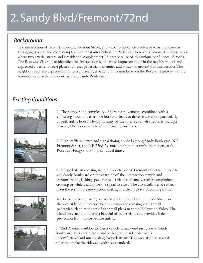
5. 72nd Avenue southbound has a vehicle turnaround just prior to Sandy
Boulevard. This creates an island with a barren sidewalk that is
uncomfortable and unappealing for pedestrians. This area also has several
poles that make the sidewalk width substandard.
3. The pedestrian crossing from the south side of Fremont Street to the north
side Sandy Boulevard on the east side of the intersection is wide and
uncomfortable, lacking space for pedestrians to maneuver after completing a
crossing or while waiting for the signal to cross. The crosswalk is also setback
from the rest of the intersection making it difficult to see oncoming traffic.
4. The pedestrian crossing across Sandy Boulevard and Fremont Street on
the west side of the intersection is a two-stage crossing with a small
pedestrian island at the tip of the small plaza near the Hollywood Video. The
island only accommodates a handful of pedestrians and provides little
protection from motor vehicle traffic.
1. The number and complexity of turning movements, combined with a
confusing stacking pattern for left turns leads to driver frustration, particularly
at peak traffic hours. The complexity of the intersection also requires multiple
crossings by pedestrians to reach many destinations.
The intersection of Sandy Boulevard, Fremont Street, and 72nd Avenue, often referred to as the Roseway
Hexagon, is wider and more complex than most intersections in Portland. There are seven marked crosswalks
where two arterial streets and a residential couplet meet. In part because of this unique confluence of roads,
The Roseway Vision Plan identified this intersection as the most important node in the neighborhood, and
expressed a desire to see a plaza and other pedestrian amenities and attractors around this intersection. The
neighborhood also expressed an interest in seeing a better connection between the Roseway Parkway and the
businesses and activities occuring along Sandy Boulevard.
2. High traffic volumes and signal timing divided among Sandy Boulevard, NE
Fremont Street, and NE 72nd Avenue contibute to a traffic bottleneck at the
Roseway Hexagon during peak travel times.
8

The Hexagon
1
2
3
4
1. A new space for a neighborhood-scaled plaza for the Roseway neighborhood could result from implementing one of the alternatives described. To accomodate vehicles between Sandy and Beech, a new vehicle turn-around will be created to align with the truck access behind the repair service center and the Roseway Theater.
2. Maintain a four lane cross-section through the intersection to ensure adequate traffic flow at this intersection.
3. A new curb extension outside of Fairly's Pharmacy improves the pedestrian environment by shortening the crossing of both Fremont and Sandy while providing additional space for furniture, cafe tables and other amenities.
4. A new curb extension shortens the pedestrian crossings of Sandy and Fremont.
5. New pavement markings highlight the unique intersection and identify it as a vibrant and important place.
5
9
Hexagon Alternatives
Full Closure of 72nd
a
b
Pros a. A large space is created for anew Roseway plaza
b. Access to 72nd north of Sandy is maintained for bicyclists and pedestrians
c. The removal of 72nd from the signal phasing improves the pedestrian environment.
Consa. Decreases access to homesand businesses on 72nd b. Increases traffic on local streets
c
Pros a. Turning movements from north and southbound 72nd are restricted to sharp right turns only, allowing 72nd to be taken out of the signal cycle; this creates clarity for drivers, pedestrians, andbicyclists.
b. Space is created for alarger neighborhood plaza
Consa. No through auto access across Sandy on 72nd
Restricted Turning Movements
b
ONLY
ONLY
a
a
Pros a. Splitting the signal at72nd increases the clarityof movements created bythe offset intersection whileproviding an additionalsignal phase for pedestriansto cross certain locations.
b. Space is created fora new Roseway plaza
Consa. No traffic turnaroundb. Decreases access to businesses & residences
Split the 72nd signal
ba
a
P
60' curb to curb
11' 11' 8'8' 8'8'
P
11' 11'
Legend
Street tree
Marked Crosswalk
Bike parking
Pedestrian-scalelighting
Pavement Markings
Plaza
Cafe seating

3. Sandy Blvd/73rd/74th/75th
Background
Existing Conditions
4. The wide unsignalized intersection at 73rd Avenue and Sandy Boulevard make
pedestrians feel unsafe and uncomfortable when waiting to cross the street. Sandy
Boulevard's four lanes also make it difficult to cross, particularly during peak hours.
There few opportunities for a pedestrian to cross safely.
1. The lack of street trees and other amenities along Sandy Boulevard contribute
to an auto-oriented street. The lack of amentities accentuates the street's width
and traffic noise. that is wide and loud. This decreases the street's attractiveness to
pedestrians.
3. Lights scaled and oriented to the automobile leave the pedestrian environment dark,
uninviting and feeling unsafe at nighttime. The current street lights provide light to the
street rather than the sidewalk. The lights encroaching the righ-of-way require that the
lights be high enough to accomodate large vehicles.The existing lights' color rendition is
amber-toned and unappealing for pedestrians.
2. The lack of marked crosswalks deters pedestrian travel across the roadway,
limiting access for pedestrians to businesses along the opposite side of Sandy
Boulevard particularly during peak vehicle travel times when crossing gaps are
infrequent.
The Sandy Boulevard streetscape lacks several pedestrian amenities. The absence of trees, trash cans and
benches counters the vision of Sandy Boulevard as the main street for the Roseway Neighborhood. In
addition, the presence of wooden utility poles with overhead wires, auto-oriented overhead lighting and
fixtures, outdated highway signage, deteriorating sidewalks, and excessive curb cuts are more appropriate
for the state highway that Sandy Boulevard used to be rather than the vital main street of an inner Northeast
neighborhood. The Roseway Vision Plan, surveys of business people and conversations with other
neighborhood interests all identify the need to establish an inviting pedestrian environment. The poor
condition of the pedestrian space is highlighted by the stretch of Sandy Boulevard between 73rd and 75th.
Here, the lack of street trees and other pedestrian amenities creates a harsh landscape for walkers,
shoppers, and neighborhood explorers.
10
5. The bus stops at the intersection of NE Sandy Boulevard and NE 74th Avenue
currently lack amenities. Both inbound and outbound stops are located adjacent to
parking lots and associated driveways.
4
3 25
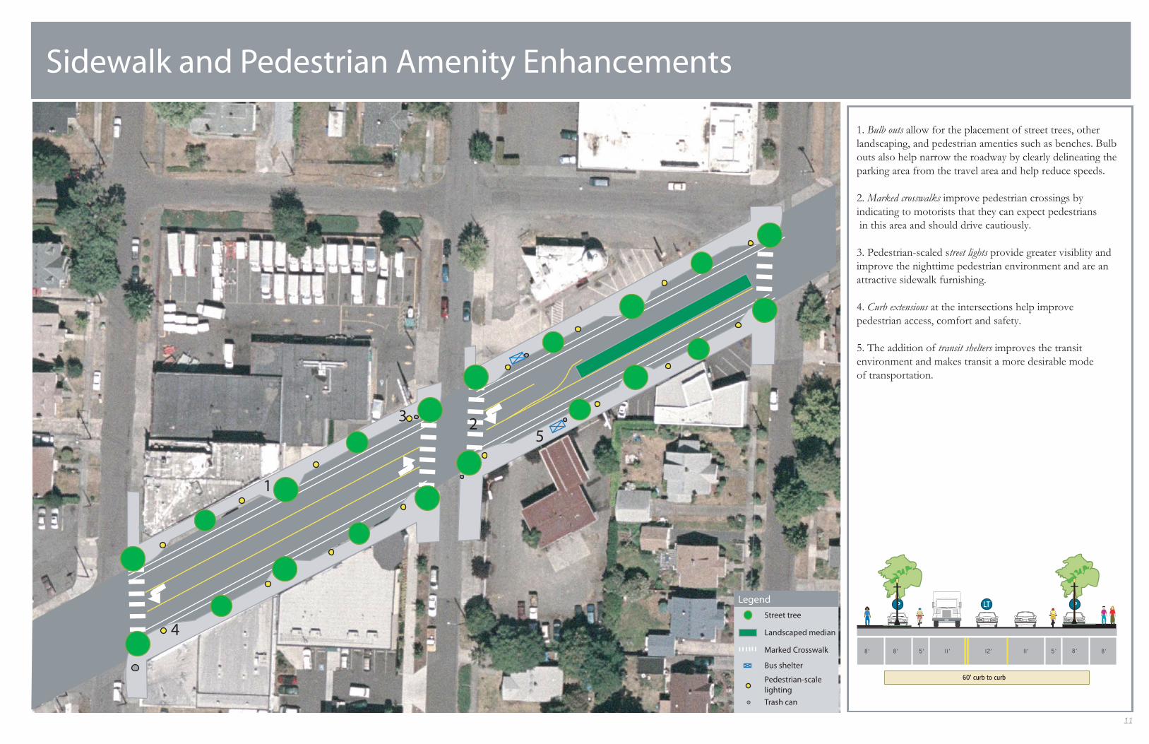
Sidewalk and Pedestrian Amenity Enhancements
1. Bulb outs allow for the placement of street trees, other
landscaping, and pedestrian amenties such as benches. Bulb
outs also help narrow the roadway by clearly delineating the
parking area from the travel area and help reduce speeds.
2. Marked crosswalks improve pedestrian crossings by
indicating to motorists that they can expect pedestrians
in this area and should drive cautiously.
3. Pedestrian-scaled street lights provide greater visiblity and
improve the nighttime pedestrian environment and are an
attractive sidewalk furnishing.
4. Curb extensions at the intersections help improve
pedestrian access, comfort and safety.
5. The addition of transit shelters improves the transit
environment and makes transit a more desirable mode
of transportation.
1
11
P PLT
60' curb to curb
11’ 12’ 11’ 5’ 8’8’ 8’8’ 5’
Legend
Street tree
Landscaped median
Marked Crosswalk
Bus shelter
Pedestrian-scalelighting
Trash can
4. Sandy Blvd/77th
Background
Existing Conditions
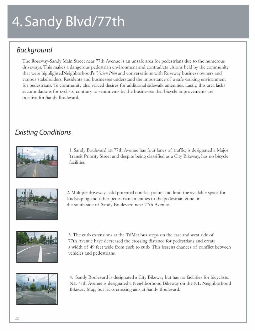
2. Multiple driveways add potential conflict points and limit the available space for
landscaping and other pedestrian amenities to the pedestrian zone on
the south side of Sandy Boulevard near 77th Avenue.
1. Sandy Boulevard att 77th Avenue has four lanes of traffic, is designated a Major
Transit Priority Street and despite being classified as a City Bikeway, has no bicycle
facilities.
The Roseway-Sandy Main Street near 77th Avenue is an unsafe area for pedestrians due to the numerous
driveways. This makes a dangerous pedestrian environment and contradicts visions held by the community
that were highlightedNeighborhood's Vision Plan and conversations with Roseway business owners and
various stakeholders. Residents and businesses understand the importance of a safe walking environment
for pedestrians. Te community also voiced desires for additional sidewalk amenities. Lastly, this area lacks
accomodations for cyclists, contrary to sentiments by the businesses that bicycle improvements are
positive for Sandy Boulevard..
12
3. The curb extensions at the TriMet bus stops on the east and west side of
77th Avenue have decreased the crossing distance for pedestrians and create
a width of 49 feet wide from curb to curb. This lessens chances of conflict between
vehicles and pedestrians.
4. Sandy Boulevard is designated a City Bikeway but has no facilities for bicyclists.
NE 77th Avenue is designated a Neighborhood Bikeway on the NE Neighborhood
Bikeway Map, but lacks crossing aids at Sandy Boulevard.

2
3
Driveway Consolidation & Shared Bus/Bicycle Lane
1. Bike lanes are dropped east of 77th due to the
curb to curb width of 54 feet.
2. Consolidating driveways creates a more continuous
sidewalk, allowing for a safer, more comfortable
pedestrian path.
3. A shared, marked bus and bicycle lane is created
to faciltate the movement of bus and bicycle users
through a skinny section of the Main Street.
4. Bike loop detectors are placed on 77th at the
intersection of Sandy Blvd and 77th, as this is a
bike route on the PDOT NE neighborhood map.
13
4
1
LT
49' curb to curb
12' 12' 13'8' 12' 13'
P
54' curb to curb
13' 12' 13' 8'8' 8'8'
P

5. Sandy Blvd/78th/79th/Failing
Background
Existing Conditions
1. The large abandoned right-of-way at the intersection of Sandy Boulevard, 78th
Avenue, and Failing Street serves little to no purpose. The intersection allows high
speed right turns off Sandy onto westbound Failing. Motorists stopped at Sandy
Boulevard and heading east on Failing are oriented at a difficult angle for visibility
and maneuvering. The large triangular section of asphalt between the three streets
creates excessive crossing distances for pedestrians.
2. The southwest corner of the intersection of Sandy Boulevard, 79th Avenue, and
Failing Street allows motorists to make high speed right turns off of Sandy onto
eastbound Failing due to its large turning radius. The recessed curb line at this
corner also doubles the crossing distance for pedestrians traveling along the south
side of Sandy.
3. Failing Street between 79th and 80th Avenues is currently 34 feet wide and lacks
continuous sidewalks and curbs. As a result, residents and visitors often park in
a manner that makes pedestrian travel along Failing difficult. Motorists traveling
eastbound on Sandy Boulevard frequently use Failing Street as a high-speed through
street to 82nd Avenue. Failing is intended for neighborhood
The intersections of Sandy Boulevard with 78th Avenue and 79th Avenue also intersects Failing Street.
The relatively unique intersections of three streets create two distinct areas that are difficult for both
pedestrians and motorists to navigate. Pedestrian crossing distances along Sandy Boulevard are two to three
times longer than the simpler two-street intersections to the east and west. Coupled with a lack of street
trees, benches, and lighting, these intersections exemplify the poor pedestrian crossings highlighted by
businesses and residents in the Community Visions and Values analysis. Businesses and residents also agree
that traffic speeds along Sandy need to decrease. The intersections at 78th and 79th Avenues illustrate
how high speeds can be maintained as motorists make right hand turns off of Sandy into residential
neighborhoods around wide-angled corners.
14

Reduction of Turning Radii and Reclamation of ROW
1. Pocket green space serves several purposes:
a) dramatic reduction of turning radii;
b) simplification of difficult intersection; and
c) banking of prime real estate for future street
front redevelopment.
2. Curb extension reduces turning radii, shortens the
crossing distances for pedestrians, and prevents right turns
directly onto NE Failing from Sandy.
3. Reduction of street width to 18 ft provides room for
sidewalks and discourages use of NE Failing Street
as a through street to NE 82nd Avenue.
12 3
15
P
54' curb to curb
13' 12' 13' 8'8' 8'8'
P
Legend
Street tree
Marked Crosswalk
Bike parking
Pedestrian-scalelighting
Street furniture
Trash can
Bus shelter

Roseway-Sandy Streetscape Concept Plan
17
1.2 Next Steps The Roseway-Sandy Streetscape Concept planning process successfully advanced the Roseway Neighborhood Association’s Vision Plan by increasing business involvement in the neighborhood visioning process, providing more detailed amenities and improvement ideas for Sandy Boulevard, and identifying and expanding relationships with planning agencies and key players at the local and regional levels. Throughout the planning process, members of Intersect Planning carefully noted topics and tasks that lay beyond the team’s focus on transportation-related improvements for the Roseway-Sandy Main Street. These are described below and are accompanied by several next steps for the RNA and the City of Portland. • Zoning and design guidelines: The City of Portland’s Comprehensive Plan identifies
several roles for the segment of Sandy Boulevard running through the Roseway neighborhood. While several of these roles are being fulfilled, many remain goals for what upper Sandy Boulevard will become in the future. The City of Portland should evaluate the community’s vision for the future of Sandy Boulevard and propose appropriate zoning and quality development provisions that set the framework for achieving the vision.
• Redevelopment likelihood: The RNA should work with the City of Portland Bureau
of Planning to assess current land use practices and identify opportunity sites for future redevelopment. While isolated segments of the study area possess land uses that are consistent with local and regional characterizations of main streets, much of the development is more appropriate to a state highway than the neighborhood’s vision for a Roseway Main Street. An action plan should be developed to encourage desired land uses at opportunity sites. Encouragement may include such steps as tax abatements, mortgage and/or lease assistance, and start-up grants, as well as other programs or tools.
• Overhead utilities: The City of Portland’s Comprehensive Plan mandates
transportation improvements along Regional Main Streets include consideration of undergrounding or reducing the visual impact of overhead utilities. Such consideration will be consistent with the desires expressed by businesses and residents of the Roseway neighborhood where overhead utilities are apparent over Sandy Boulevard.
• Signal timing: The Roseway-Sandy Streetscape Concept Plan includes a reduction
in traffic speeds and the number of traffic lanes through the corridor. While traffic calming techniques utilized in the corridor may divert a portion of through traffic to Interstate-84, City of Portland engineers should examine signal timing to ensure traffic flow is optimized. Additionally, priority should be given to buses and pedestrians wherever possible.

Roseway-Sandy Streetscape Concept Plan
18
• Lane configuration transitions: There are several locations in the Roseway-Sandy
Streetscape Concept Plan near the Roseway Hexagon and the intersection of Sandy Boulevard and NE 77th Avenue where the number of lanes increases and decreases. City of Portland engineers should examine these transitions and determine the length and location for safe transition zones.
• Speed limits: The Roseway-Sandy Streetscape Concept Plan includes several
techniques for calming traffic. The current speed limit through the corridor is 35 miles per hour and actual speeds can approach 50 miles per hour. Thus, traffic calming techniques should be supported with reductions in speed limits to 30 miles per hour through the Roseway neighborhood. More aggressive speed enforcement along Sandy Boulevard would reinforce the speed limit and calm traffic while improving the pedestrian environment.
• Sidewalk width: Sidewalks along Sandy Boulevard in the study area are primarily
six feet in width; this is substandard for main streets in the City of Portland. The Roseway-Sandy Streetscape Concept Plan suggests sidewalk width expansion at and near intersections, but uses the existing curb line on the majority of block faces. Concessions by the planning team were made regarding sidewalk width to reduce the overall cost of the main street improvements with the assumption that most properties will be redeveloped. A condition of redevelopment will include a requirement to increase the building setback and effectively widen the sidewalks. It should be noted that maintaining the existing curb line also allowed for the inclusion of planted medians and bike lanes.
• Street crowning: A problem that was encountered in the planning of lower Sandy
Boulevard related to sidewalk width and the street crown. Ownership of Sandy Boulevard was only recently transferred to the City of Portland from the State of Oregon. The crown, where the roadway is created with a higher center and slopes downwards to the curb line, and drainage standards differ for the two jurisdictions. The dramatic crown along Sandy Boulevard implemented for its use as a state highway does not support widening of the sidewalks necessary for an active and pedestrian-friendly main street. Thus, the City of Portland Office of Transportation will need to examine limitations and potential solutions for sidewalk widening in relation to street crowning.
• Transitions to the east and west: Planning for lower Sandy Boulevard terminates at
NE 54th Avenue. The current Roseway-Sandy Streetscape Concept Plan includes Sandy Boulevard from NE 68th Avenue to NE 80th Avenue. The City of Portland will need to work closely with the Rose City Park and Roseway Neighborhoods to connect the two main streets with active commercial centers in the Hollywood District and Roseway Neighborhood. Additionally, the City of Portland will need to work with the Roseway, Sumner, and Madison South Neighborhoods to

Roseway-Sandy Streetscape Concept Plan
19
connect the Roseway Main Street with NE 82nd Avenue and the rest of Sandy Boulevard to the east. This connection will become especially relevant as residents begin to occupy the new housing development at the intersection of Sandy Boulevard and NE 82nd Avenue.
• Funding: The City of Portland is currently in the process of applying for a
Transportation Growth Management (TGM) grant for the planning of upper Sandy Boulevard from NE 54th Avenue to NE 122nd Avenue. The RNA and Central Northeast Neighbors (CNN) have provided letters in support of the grant application. While City of Portland staff are optimistic about being awarded the TGM grant for developing an upper Sandy improvement plan, the RNA and the City of Portland should actively search for additional funding opportunities, particularly for implementing the planned improvements.
• Outreach: The RNA should continue to reach-out to the Roseway businesses,
building on previous efforts, as well as this planning effort, to increase communication and cooperative efforts at improving the physical environment and vitality of Sandy Boulevard.

Roseway-Sandy Streetscape Concept Plan
20

Roseway-Sandy Streetscape Concept Plan Planning Overview
21
II. Planning Overview Three analyses were completed in preparation for the design of the Roseway-Sandy Streetscape Concept Plan. The planning approach recognizes that the Concept Plan must embody the interests, concerns, and values of a diverse community. The completed analyses informed and guided the design of the Concept. The analyses are a(n):
1. Community Visions and Values Analysis 2. Existing Conditions Analysis 3. Portland Main Street Case Study Analysis and Main Street Transportation
Solutions Toolbox Together, the three elements of the analysis provide a rich and broad sampling of the community interests and their perspectives on transportation improvements to Sandy Boulevard. The different and complementary approaches provide a level of guidance in determining the appropriate degree(s) of change and general streetscape environment appropriate for the Roseway Neighborhood. The analyses complement each other by informing the design, data collection, and examination of findings of the other analyses. In general, the Community Visions and Values Analysis documents a range of community opinions that assists in the identification and measurement of appropriate variables for the Existing Conditions Analysis. The syntheses of these two analyses present an assortment of community goals confronted by barriers in the physical condition of the transportation environment. The Portland Main Street Case Study Analysis and Main Street Transportation Solutions Toolbox respond to these problems by describing how they have been dealt with in other planning efforts through the development of flexible transportation solutions. Those solutions, bearing direct relationship to the community’s values and visions, are applied in the Concept Plan. The analyses assume that the Main Street’s planning and development is a community-driven process that involves a variety of local interests and stakeholders. The process creates a unique and powerful opportunity for local residents, businesses, and property owners to shape the development and character of their neighborhood. The approach presented in this report attempts to summarize the community’s visions and values while presenting a detailed discussion on how transportation improvements may be perceived by affected parties and interests.

Roseway-Sandy Streetscape Concept Plan Planning Overview
22

Roseway-Sandy Streetscape Concept Plan Planning Overview
23
2.1 Background Metro Region 2040 Growth Concept Plan The Metro Region 2040 Growth Concept Plan launched an ambitious vision for the Portland metropolitan region’s future. Citizen concern over the pressures of a growing population on land use, public infrastructure, natural environment, and quality of life guided the creation of a regional Concept Plan. Accordingly, this long- range planning project sought to direct how future growth in jobs, transportation facilities, open spaces and housing would be located throughout the region. The plan called for Metro to direct growth into designated centers and corridors that are stratified in both scale and character. Upon adoption of the Metro Region 2040 Growth Concept Plan, local and regional planning agencies have developed consistent strategies that focus planning and funding into these areas for future development. Main Streets Main Streets represent the most immediate connection of the Metro Region 2040 Growth Concept Plan to the region’s neighborhoods. From both a local and regional perspective, successful Main Street development fosters community-level business districts that are an essential part of vibrant, livable neighborhoods. Main Streets have high land use densities with concentrations of shopping, services, entertainment and restaurants that serve the immediate community. In these areas, increased housing options mix with a variety of other uses. Quality pedestrian environments and regular transit service are crucial elements for Main Street development. Differences exist between many of the Metro Region 2040 Growth Concept Plan designations of Main Street and the current conditions of these designated areas. Many of these Main Streets face deficiencies in transportation infrastructure and land use policies that structurally limit community businesses development. Metro has funded transportation improvements to reconfigure streets, redesign intersections, and add other street amenities in an effort to create an environment capable of supporting Main Street type development. In Portland, the planning and development of Main Streets has been a community-driven process that involves a variety of local interests and stakeholders. The challenge of realizing the Main Street concept creates a unique and powerful opportunity for local residents to shape development in their neighborhoods. Many local neighborhoods, however, lack the necessary time and technical resources to address the complex set of issues in community planning and development. Sandy Boulevard and Roseway Neighborhood Sandy Boulevard traverses the Roseway neighborhood in Northeast Portland. While this section of Sandy Boulevard is designated a Main Street, it lacks many desirable “Main Street” features intended to provide residents with services and opportunities

Roseway-Sandy Streetscape Concept Plan Planning Overview
24
for community identity, interpersonal interaction, and personal health. During the early 1900s, a streetcar operated along Sandy to the Roseway Neighborhood. The area has retained some of the business and neighborhood character reminiscent of many streetcar communities where the existing land uses suggest a high potential for future development envisioned by the Metro Region 2040 Growth Concept Plan. Residents of the Roseway neighborhood, acting through their neighborhood association, created a Vision Plan in 2002 that identified the immediate need to promote community-appropriate development along Sandy. The Roseway Vision Steering Committee of the Roseway Neighborhood Association (RNA) held meetings in 2000 and 2001 for area residents and business owners to discuss their views on how improvements could be made in the area. The Vision Plan successfully formed new relationships, set goals, and brought the notion of planning to the neighborhood’s agenda. While the Vision Plan identified specific action items for Sandy Boulevard, members of the RNA desire greater representations of the visions and needs of area business and property owners.

Roseway-Sandy Streetscape Concept Plan Planning Overview
25
2.2 Problem Statement The Roseway neighborhood in Northeast Portland lacks a vibrant pedestrian-scale commercial and retail area that would provide residents with a range of services and opportunities for community identity, interpersonal interaction, and personal health. The RNA has developed a general plan communicating the community’s vision for a vibrant Main Street along Sandy Boulevard. A lack of resources and technical expertise has left a gap between the community’s broad vision for the future and the requisite level of detail needed in the City of Portland’s transportation plans. Intersect Planning has assisted the RNA in developing a more detailed vision of their Main Street by creating a Streetscape Concept Plan. The Concept Plan is designed to advance the Roseway neighborhood’s main street vision by bridging the gap between the neighborhood and regional planning agencies. At this time, the neighborhood has yet to receive regional planning and implementation dollars for the necessary Main Street transportation investments.
Roseway-Sandy Streetscape Concept Plan Planning Overview
26
2.3 Planning Intentions Top-down or imposed planning could create undesirable and long lasting consequences for the Roseway neighborhood that ignore the neighborhood’s history and residents’ and businesses’ unique values and visions. Incorporating neighborhood values and visions with the requisite level of technical assistance into a Streetscape Concept Plan for the RNA has the potential to invigorate local residents while connecting them to city and regional planners and their resources. In this way, Intersect Planning hopes the planning process will create local enthusiasm and support for distinct concepts that feed into regional funding opportunities for transportation investments.
Roseway-Sandy Streetscape Concept Plan Existing Conditions Analysis
27
III. Existing Conditions Analysis The existing conditions analysis was an integral component of the Roseway Sandy Streetscape planning process. The existing conditions along NE Sandy Boulevard from NE 68th Street to NE 80th Street are essential to establishing a baseline and identifying aspects of the street environment that require attention. For the current planning process, Intersect Planning focused on six distinct aspects of the study area.
• Street classifications • Physical street features • Auto volume, speeds, & accidents • Pedestrian crossing gaps • Transit ridership • Zoning

Roseway-Sandy Streetscape Concept Plan Existing Conditions Analysis
28

Roseway-Sandy Streetscape Concept Plan Existing Conditions Analysis
29
3.1 Street Classifications The Transportation Element of the City of Portland’s Comprehensive Plan consists of two goals: Goal 6, Transportation, and Goal 11B, Public Rights-of-Way. Within these goals are street classification maps that guide the use of the transportation system. Street classification descriptions and designations describe the types of motor vehicle, transit, bicycle, pedestrian, truck, and emergency vehicle movement that should be emphasized on each street. As such, classification descriptions and designations are used to determine the appropriateness of the street improvements and to make recommendations on new and expanding land uses through the City of Portland’s land use review processes. Table 1. Comprehensive Plan Street Classifications of Roseway-Sandy Main Street Category Classification
Traffic Major City Traffic Street
Transit Major Transit Priority Street
Bicycle City Bikeway
Pedestrian City Walkway
Freight Minor Truck Street
Emergency Major Emergency Response
Street Design Regional Main Street According to the Transportation Element, all of a street’s classifications must be considered in designing street improvements and allocating funding. While a proposed project may serve only one classification, improvements should not preclude future modifications to accommodate other classifications of the street. The street classifications from the Transportation Element of the City of Portland’s Comprehensive Plan for NE Sandy Boulevard through the study area are shown in Table 1 above. This section describes each of the classifications, how the type of street should function, and what types of land uses this classification of street should serve. The intention of a Major City Traffic Street is to serve as the principal route for traffic that has at least one trip end within a transportation district. These streets should provide motor vehicle connections among the central city, regional centers, town centers, industrial areas, and intermodal facilities. Auto-oriented development should locate adjacent to Major City Traffic Streets, but should orient to pedestrians along streets like Sandy Boulevard that also have a classification as a Transit Street or a Pedestrian District.

Roseway-Sandy Streetscape Concept Plan Existing Conditions Analysis
30
On-street parking may be removed and additional right-of-way purchased to provide adequate traffic access when consistent with the street design designation of the street. Evaluation of on-street parking serving adjacent land uses and improving the safety of pedestrian and bicyclists is necessary when making changes to the roadway on a Major City Traffic Street. The Roseway-Sandy Main Street is a Major Transit Priority Street. Therefore, it is intended to provide for high-quality transit service that connects the central city and other regional and town centers and main streets. Transit-oriented land uses should be encouraged to locate along this type of street and not auto-oriented development except where the street is outside the central city, regional or town center, station community, or main street and is also classified as a Major City Traffic Street (like Sandy Boulevard). Land use densities should vary directly with the existing and planned capacity of transit service. For the benefit of pedestrians and bicyclists, safe and convenient access near and on Major Transit Priority Streets are necessary. Also, the employment of transit-preferential measures, such as signal priority and bypass lanes, add benefits for flow of transit. Where compatible with adjacent land use designations, right-of-way acquisition or parking removal may occur to accommodate these preferential measures that can also improve access to transit. A Major Transit Priority Street should also provide safe and convenient transfer points for users with covered waiting areas, transit route information, benches, trash receptacles, enhanced signing, lighting, and telephones. Where there is limited transit service, it should stop at transfer points and activity centers along the Major Transit Priority Streets. Sandy Boulevard through the Roseway neighborhood is a City Bikeway, meaning it intends to serve all bicycle users and all types of bicycle trips in the Central City, regional and town centers, station communities, and other employment, commercial, institutional, and recreational destinations. Due to this designation, improvements that should be considered include the following design treatments: bicycle lanes, wider travel lanes, wide shoulders on partially improved roadways, bicycle boulevards, and signage for local street connections. When bicycle lanes are not feasible, traffic calming, bicycle boulevards, or similar techniques will be considered to allow bicyclists to share travel lanes safely with motorized traffic. On-street motor vehicle parking may be removed on City Bikeways to provide bicycle lanes, except where parking is determined to be essential to serve adjacent land uses and other feasible options are not available to provide the parking on-site. As for bicycle parking, there should be long-term and/or short-term bicycle parking to meet the need at destinations on City Bikeways.

Roseway-Sandy Streetscape Concept Plan Existing Conditions Analysis
31
The Concept Plan area is also considered a City Walkway by the City of Portland. This means that it is intended to provide safe, convenient, and attractive pedestrian access to activities along major streets and to recreation and institutions. As a City Walkway, Sandy Boulevard should provide connections between neighborhoods and provide access to transit. Zoning on designated City Walkways should serve dense commercial areas and major destinations. Although auto-oriented land uses are allowed on these streets, site development standards should address the needs of pedestrian access. Consideration for special design treatments is also necessary for the Roseway-Sandy Main Street because it is designated as City Walkway and Regional Main Street. A Regional Main Street is intended to accommodate motor vehicle traffic with features that facilitate public transportation, bicycles, and pedestrians. The Roseway-Sandy Streetscape Concept Plan hopes to improve the area in this capacity. Development on a Regional Main Street consists of a mix of uses that are oriented to the street and usually include four vehicle lanes, with additional lanes, such as turn lanes, or one-way couplets in some situations. Regional Main Street design shall also consider the following: low to moderate vehicle speeds; the use of medians and curb extensions to enhance pedestrian crossings where wide streets make crossing difficult; combined driveways; on-street parking where possible; wide sidewalks with pedestrian amenities such as benches, awnings and special lighting; landscape strips, street trees, or other design features that create a pedestrian buffer between curb and sidewalk; improved pedestrian crossings at all intersections and mid-block crossings where intersection spacing exceeds 400 feet; striped bike lanes to wide outside lane; and vehicle lane widths that consider the above improvements. Many of these attributes are in this Concept Plan. The study area is a Minor Truck Street, meaning there is discouragement of land uses that generate large numbers of truck trips, such as regional truck terminals. As a Minor Truck Street, non-local truck trips are also discouraged in the Roseway-Sandy area. Sandy Boulevard is a Major Emergency Response Street. This designation means that it serves as a primary, direct leg of emergency response trips within the City’s network. Design treatments on Major Emergency Response Streets should enhance mobility for emergency response vehicles by employing preferential or priority treatments and these streets are not eligible for traffic slowing devices in the future.

Roseway-Sandy Streetscape Concept Plan Existing Conditions Analysis
32
NE Sandy Boulevard serves many roles in the city’s and the region’s transportation systems. Several of the designations for Sandy Boulevard fail to mirror the current conditions along this “regional main street.” Specifically, the majority of development is auto-oriented and is not oriented to the pedestrian. Access to transit is difficult if such access requires crossing Sandy Boulevard. The study area is designated as both a City Bikeway and Walkway, yet lacks any bicycle amenities and possesses very few pedestrian amenities. Most important, the study area does not fit the description of a Regional Main Street. The remainder of this report illustrates the overall high traffic speeds, lack of pedestrian amenities, and absence of bicycle amenities.

Roseway-Sandy Streetscape Concept Plan Existing Conditions Analysis
33
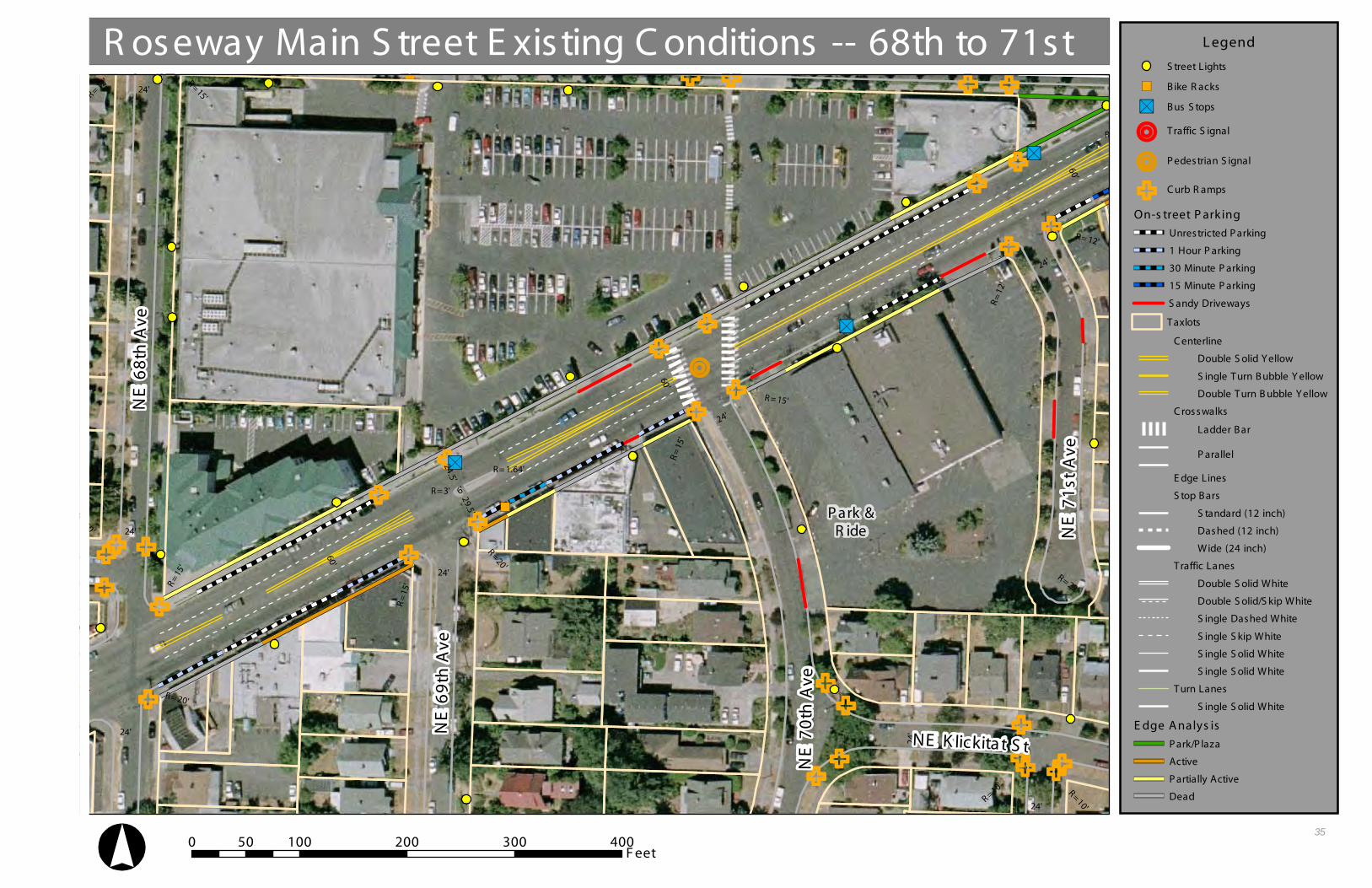
3.2 Physical Street Features & Streetscape Edge Activity The assessment of the physical street environment along NE Sandy Boulevard between NE 68th Avenue and NE 80th Avenue consisted of a combination of digital mapping and field observations. The City of Portland maintains digital representations of geographic information in the City’s enterprise geographic information system, the City Geographic Information System (CGIS). Several variables of interest have a corresponding shapefile in CGIS. For these variables, the data was mapped and checked in the field. For variables lacking a shapefile in CGIS, descriptive and locational information was gathered during field observations and shapefiles were created. The data that was collected is represented in the following tables and maps. An additional component of the field observations included a streetscape edge analysis. An edge analysis is conducted along a street’s block faces. An edge condition is designated for segments of a block face corresponding to different existing uses. The following four edge conditions were used in the current analysis: park/plaza, active, partially active, or dead. Park/plaza indicates that a park or plaza abuts the street at a particular location. An active designation indicates that a business or residence has relatively high foot traffic, welcoming entries, and visual transparency created by windows and other architectural elements. A partially active designation indicates that a business or residence has relatively little foot traffic, utilitarian entries, and moderate visual transparency. A dead designation indicates that a structure has little to no foot traffic, no usable entries on a block face, and no visual transparency. Parking lots also receive a designation as dead.

Roseway-Sandy Streetscape Concept Plan Existing Conditions Analysis
34
Table 2. Existing Conditions of NE Sandy Boulevard from NE 68th to 71st Street
68th to 69th 69th to 70th 70th to 71st
Variable Units North South North South North South
Pavement width Feet 60 60 60 60 60 60
30 min Parking Number 5 0 0 2 0 0
1 hour parking Number 0 4 0 5 0 0
No limit parking Number 0 3 3 0 4 2 Total on-street parking Number 5 7 3 7 4 2
Off-street parking Number 21 0 0 5 115 78
Sidewalk width Inches 72 90 72 90 72 90
Street trees Number 0 0 0 0 0 7
Benches Number 0 0 1 0 0 1
Bus shelters Number 0 0 1 0 0 0
Trash cans Number 0 0 1 0 0 0
Bike rack Number 0 0 0 1 0 0
Planting Strip Feet 44 0 44 0 44 0
Driveways Number 0 0 1 1 0 2
Street lights Number 2 1 0 2 2 1
Curb ramps Number 2 2 2 2 2 2
Bus stops Number 0 0 1 0 0 1
R=15'
R= 20'
R=20'
R= 12'
R=10'
R=12' R= 15'
R=
15'
R= 12'
R=
12'
R=
15'
R= 15'R
=15
'
R=20'
R=22'
R=10'
R=10'
24'
24'
24'
24'
24'
24'
24'
24'
60'
60'
60'
60'
R= 3'
R= 1.64'
6'
29.5'
24.5'
R= 1.5'N
E 6
8th
Av e
NE
68
th A
v e
NE
69
th A
veN
E 6
9th
Ave
NE
70
th A
v eN
E 7
0th
Av e
NE K lickitat S tNE K lickitat S t
NE
71
s t A
v eN
E 7
1s t
Av e
R oseway Main S treet E xisting C onditions -- 68th to 71st
0 100 200 300 40050F eet
L egend
S treet Lights
B ike R acks
B us S tops
Traffic S ignal
P edestrian S ignal
C urb R amps
On-s treet P ark ing
Unrestricted P arking
1 Hour P arking
30 Minute P arking
15 Minute P arking
S andy Driveways
Taxlots
C enterline
Double S olid Y ellow
S ingle Turn B ubble Y ellow
Double Turn B ubble Y ellow
C rosswalks
Ladder B ar
P arallel
E dge Lines
S top B ars
S tandard (12 inch)
Dashed (12 inch)
Wide (24 inch)
Traffic Lanes
Double S olid White
Double S olid/S kip White
S ingle Dashed White
S ingle S kip White
S ingle S olid White
S ingle S olid White
Turn Lanes
S ingle S olid White
E dge A nalys is
P ark/P laza
Active
P artially Active
Dead
P ark &R ide
P ark &R ide
35

Roseway-Sandy Streetscape Concept Plan Existing Conditions Report
36
Table 3. Existing Conditions of NE Sandy Boulevard from NE 71st to 74th Street
71st to 72nd 72nd to 73rd 73rd to 74th
Variable Units North South North South North South
Pavement width Feet 60 60 60 60 60 60
30 min Parking Number 0 2 0 0 1 0
1 hour parking Number 0 0 2 3 0 1
No limit parking Number 0 2 2 1 5 4 Total on-street parking Number 0 4 4 4 6 5
Off-street parking Number 0 19 18 3 3 7
Sidewalk width Inches 72 86.5/147/122/75 72 57/60/78 192/90 72
Street trees Number 0 2 0 0 0 0
Benches Number 3 0 0 0 0 0
Bus shelters Number 1 1 0 0 0 0
Trash cans Number 0 0 0 0 0 0
Bike rack Number 0 0 1 1 1 0
Planting Strip Feet 44 0 0 0 0 0
Driveways Number 0 1 2 1 1 0
Street lights Number 1 2 2 3 2 1
Curb ramps Number 4 3 4 3 3 2
Bus stops Number 1 1 0 0 0 0

R=10'
R=10'
R=
12'
R=
30'
R=24'
R=12' R=12'
R= 9.5'
R= 15'R=15'
R=15'
24' 24'
24'24'
33.5'
33.5'
24'
24'
R= 10' R= 15' R=15'R=15'R=15'
R=12'
R=15'
R= 15'
R=20'
R= 30'
R=20'
R=
15'
R= 25'
R=18'
R=18'R= 18'
R=18'
R=18'
24'24'
24'
24'
60'
60'
5'
5'
3'
3'
22'
R=5'
R=5'
27'
28.36'27'
28.36'
R= 1.64'
R= 3'
R= 3'
R=15'
R=15'
R=15'
R=15'R= 15'
33'
24'
43' 24'
24'44
'
4 0'
R= 2.5'
R=
2.5'
R= 12'
R=
12'
R=
41' R=
10'
3 6'
33'
24'
60'
25'22'
8'
R= 1.5'
R= 3'
R=15'
R= 15'
NE
71
s t A
v eN
E 7
1s t
Av e
NE
72
nd
Av e
NE
72
nd
Av e
NE
73
rd A
veN
E 7
3rd
Ave
NE F remont S tNE F remont S t
NE
74
t h A
v eN
E 7
4t h
Av e
R oseway Main S treet E xisting C onditions -- 71st to 74th
0 100 200 300 40050F eet
L egend
S treet Lights
B ike R acks
B us S tops
Traffic S ignal
P edestrian S ignal
C urb R amps
On-s treet P ark ing
Unrestricted P arking
1 Hour P arking
30 Minute P arking
15 Minute P arking
S andy Driveways
Taxlots
C enterline
Double S olid Y ellow
S ingle Turn B ubble Y ellow
Double Turn B ubble Y ellow
C rosswalks
Ladder B ar
P arallel
E dge Lines
S top B ars
S tandard (12 inch)
Dashed (12 inch)
Wide (24 inch)
Traffic Lanes
Double S olid White
Double S olid/S kip White
S ingle Dashed White
S ingle S kip White
S ingle S olid White
S ingle S olid White
Turn Lanes
S ingle S olid White
E dge A nalys is
P ark/P laza
Active
P artially Active
Dead
37

Roseway-Sandy Streetscape Concept Plan Existing Conditions Analysis
38
Table 4. Existing Conditions of NE Sandy Boulevard from NE 74th to 77th Street
74th to 75th 75th to 76th 76th to 77th
Variable Units North South North South North South
Pavement width Feet 60, 54 60, 54 54 54 54, 49.15
54, 49.15
30 min Parking Number 0 0 0 0 0 0
1 hour parking Number 0 0 0 0 0 0
No limit parking Number 0 0 5 1 3 1 Total on-street parking Number 0 0 5 1 3 1
Off-street parking Number 26 6 7 0 0 9
Sidewalk width Inches 90/208 72 126/72 72 72 72/185
Street trees Number 3 (4x3) 0 0 7 0 4
Benches Number 0 0 0 0 0 0
Bus shelters Number 0 0 0 0 0 0
Trash cans Number 0 0 0 0 0 0
Bike rack Number 1 0 0 0 0 0
Planting Strip Feet 0 60 48 56 60 56
Driveways Number 2 4 1 0 2 3
Street lights Number 1 1 1 2 2 1
Curb ramps Number 2 2 3 4 3 2
Bus stops Number 1 1 0 0 0 1

R=15'
R= 30'
R= 18'
R= 18'
R= 30'
R=
65'
R=18'
R=18' R=18'
R=18'
R= 18'R=15'
R= 15'
R=
18'
R=18'
R= 30'
R= 25'
R= 18'
R=18'
R=18'
R=18'R=12' R=12'
R=18'
R=18'
R= 30'
R=
18'
24'24'
24'
24'
24'
24'
24'2 4
'
2 4'
34'
60'
54'
54' 24'
49.15'
49.15'
R=15'
R=15'
R=15'
R=15'
R=15'
R=15'
R=15
'
R=
15'
27'
28.36'27'
28.36'
R= 1.64'
R= 1.64'R= 3'
R= 3'
NE
74
th A
v eN
E 7
4th
Av e
NE
75
t h A
veN
E 7
5t h
Ave
NE
76
t h A
veN
E 7
6t h
Ave
NE B eech S tNE B eech S t
NE
77
t h A
veN
E 7
7t h
Ave
R oseway Main S treet E xisting C onditions -- 74th to 77th
0 100 200 300 40050F eet
L egend
S treet Lights
B ike R acks
B us S tops
Traffic S ignal
P edestrian S ignal
C urb R amps
On-s treet P ark ing
Unrestricted P arking
1 Hour P arking
30 Minute P arking
15 Minute P arking
S andy Driveways
Taxlots
C enterline
Double S olid Y ellow
S ingle Turn B ubble Y ellow
Double Turn B ubble Y ellow
C rosswalks
Ladder B ar
P arallel
E dge Lines
S top B ars
S tandard (12 inch)
Dashed (12 inch)
Wide (24 inch)
Traffic Lanes
Double S olid White
Double S olid/S kip White
S ingle Dashed White
S ingle S kip White
S ingle S olid White
S ingle S olid White
Turn Lanes
S ingle S olid White
E dge A nalys is
P ark/P laza
Active
P artially Active
Dead
39

Roseway-Sandy Streetscape Concept Plan Existing Conditions Analysis
40
Table 5. Existing Conditions of NE Sandy Boulevard from NE 77th to 80th Street
77th to 78th 78th to 79th 79th to 80th
Variable Units North South North South North South
Pavement width Feet 49.15, 54
49.15, 54 54 54 54 54
30 min Parking Number 0 0 0 0 0 0
1 hour parking Number 0 0 0 0 0 0
No limit parking Number 3 3 4 2 0 2 Total on-street parking Number 3 3 4 2 0 2
Off-street parking Number 20 17 0 20 13 13
Sidewalk width Inches 72/186 185/62 180/72 72 72 72
Street trees Number 2 (4x4.5) 3 3
(4x4.5) 0 0 0
Benches Number 0 0 0 0 0 1
Bus shelters Number 1 1 0 0 0 1
Trash cans Number 0 0 0 0 0 1
Bike rack Number 0 0 0 0 0 0
Planting Strip Feet 0 60 0 54 66 54
Driveways Number 1 3 1 2 0 2
Street lights Number 2 1 2 1 0 2
Curb ramps Number 2 3 3 4 2 2
Bus stops Number 1 0 0 0 1 1

R=30
'
R= 20'
R=
48'
R=18'
R=18'
R=18'
R=18'
R=18' R=18'
R=18'R= 30'
R= 18'
R=18'
R=18'
R=10'
R= 12'
R=15'
R=18'
R=60'
R= 30'
R=18'R=18
'
R=30'
R=18'
R=30'
24'
24'
24'
24'24'
24'
2 4'
3 4'
54'
54'
54'
16'
24'
R=1.64'
R=3' 24.4'25'
49.15'
49.15'
R=15'
R=15'
R=15'
R=15'
R=15'
R=15
'
R=
15'
NE
77
th A
v eN
E 7
7th
Av e
NE
78
t h A
veN
E 7
8t h
Ave
NE
79
t h A
veN
E 7
9t h
Ave
NE F ailing S tNE F ailing S t
NE
79
t h A
veN
E 7
9t h
Ave
R oseway Main S treet E xisting C onditions -- 77th to 80th
0 100 200 300 40050F eet
L egend
S treet Lights
B ike R acks
B us S tops
Traffic S ignal
P edestrian S ignal
C urb R amps
On-s treet P ark ing
Unrestricted P arking
1 Hour P arking
30 Minute P arking
15 Minute P arking
S andy Driveways
Taxlots
C enterline
Double S olid Y ellow
S ingle Turn B ubble Y ellow
Double Turn B ubble Y ellow
C rosswalks
Ladder B ar
P arallel
E dge Lines
S top B ars
S tandard (12 inch)
Dashed (12 inch)
Wide (24 inch)
Traffic Lanes
Double S olid White
Double S olid/S kip White
S ingle Dashed White
S ingle S kip White
S ingle S olid White
S ingle S olid White
Turn Lanes
S ingle S olid White
E dge A nalys is
P ark/P laza
Active
P artially Active
Dead
41

Roseway-Sandy Streetscape Concept Plan Existing Conditions Analysis
42
Of particular interest in the physical street feature analysis is the abundance of parking along this segment of Sandy Boulevard. There are approximately 75 on-street spaces on Sandy from NE 68th Street to NE 80th Street. The spaces are not striped and two-thirds have no time limit. There are also another 400 off-street spaces serving the businesses along the Roseway-Sandy Main Street. This segment of Sandy is served very well by transit with ten bus stops. Six of the ten bus stops have shelters with benches and bus schedules. Field observations and analyses also revealed a general lack of pedestrian and bicycle amenities. There are only three benches that are not associated with transit, one trash can, no sidewalk dining, and only four bike racks. There are over 60 curb ramps along the 12 block segment of Sandy Boulevard. Further analyses of the existing conditions along NE Sandy Boulevard from NE 68th Avenue to NE 80th Avenue revealed several thematic areas demanding attention in future transportation improvements. These include poor pedestrian and bike access to transit, institutions, and other destinations; a general lack of public gathering spaces and a poor connection to existing open space; a lack of pedestrian amenities and the presence of substandard sidewalks; an oversupply of off street parking and associated driveways; and dangerous, high-speed turning movements from Sandy Boulevard to neighborhood streets. Poor pedestrian and bike access to transit, institutions, businesses, and open space • The lack of marked crosswalks deters pedestrian travel across the roadway and
decreases the connection between the pedestrian and the businesses along the street.
• The existing pedestrian refuges increase the hardscape area in the study section
and are narrow. They provide insufficient protection or refuge for pedestrians from vehicles as they wait to cross Sandy Boulevard.
• The majority of Sandy Boulevard through the study section is 60 feet in width
from curb to curb. This is a long distance to cross as a pedestrian, especially for older adults and younger school-age children. The wide street also encourages motorists to travel at speeds higher than the posted limit.
• The pedestrian crossing from Fremont Street to Sandy Boulevard on the eastside
of the “hexagon” intersection is wide and uncomfortable, lacking space for pedestrians to maneuver after completing a crossing or while waiting for the signal to cross. The crosswalk is also setback from the rest of the intersection making it difficult to see oncoming traffic.

Roseway-Sandy Streetscape Concept Plan Existing Conditions Analysis
43
• 72nd Avenue southbound has a vehicle turnaround just prior to Sandy Boulevard. This creates an island with a barren sidewalk that is uncomfortable and unappealing for pedestrians. This area also has several poles that make it too narrow for pedestrians.
Lack of pedestrian amenities and substandard sidewalks • The lack of street trees and other amenities along Sandy Boulevard creates an
auto-oriented street that is wide and loud. This greatly decreases the streets attractiveness for pedestrians.
• Lights scaled to the automobile leave the pedestrian environment dark,
uninviting and unsafe at nighttime. The existing lights’ color is amber-toned and unappealing for users.
• The pedestrian crossing from Sandy Boulevard across Fremont Street on the
west side of the “hexagon” intersection is a two-stage crossing with a small pedestrian island at the tip of the small plaza near the Hollywood Video. The island only accommodates a handful of pedestrians and provides little protection from motor vehicle traffic.
• Failing Street between 79th and 80th Avenues is currently 34 feet wide and lacks
continuous sidewalks and curbs. As a result, residents and visitors often park in a manner that makes pedestrian travel along Failing difficult. Motorists traveling eastbound on Sandy Boulevard frequently use Failing Street as a through street to 82nd Avenue.
Oversupply of parking and associated driveways • Two lanes in both the east and westbound directions, and plentiful and
underutilized on-street parking encourage motor vehicles to consistently travel over the posted speed limit. This creates a loud and unpleasant pedestrian atmosphere.
• Multiple driveways create multiple conflict points of interest while limiting the
ability to add landscaping and other pedestrian amenities to the pedestrian zone.

Roseway-Sandy Streetscape Concept Plan Existing Conditions Analysis
44
Dangerous intersections • The number and complexity of turning movements, combined with a confusion
stacking pattern for left turns, leads to driver frustration, particularly at traffic peaks.
• The wide unsignalized intersection at 73rd Avenue and Sandy Boulevard make
pedestrians feel unsafe and uncomfortable when waiting to cross the street. Sandy Boulevard's four lanes also make it difficult to cross, presenting many opportunities for potential crashes.
• The large excess of right-of-way at the intersection of Sandy Boulevard, 78th
Avenue, and Failing Street serves little purpose. The intersection allows high speed right turns off of Sandy onto westbound Failing. Motorists stopped at Sandy Boulevard and heading east on Failing are oriented at a difficult angle for visibility and maneuvering. The large triangular section of asphalt between the three streets makes for unnecessarily long crossing distances.
• The southwest corner of the intersection of Sandy Boulevard, 79th Avenue, and
Failing Street allows motorists to make high speed right turns off of Sandy onto eastbound Failing. The recessed curb line at this corner also doubles the crossing distance for pedestrians traveling along the south side of Sandy.

Roseway-Sandy Streetscape Concept Plan Existing Conditions Analysis
45
3.3 Auto Volume, Speeds, & Accidents A major aspect of the street environment along upper Sandy Boulevard is the automobile. Intersect Planning attempted to better understand the nature of the automobile in the study area by examining both traffic volumes and traffic speeds. Traffic volumes were provided from the City of Portland for the intersections of NE Sandy Boulevard and NE 70th, 80th, and 82nd Streets. The City of Portland Office of Transportation uses automatic traffic counters. All counts used in the current planning process were volume counts. Volume counts are the most common type of traffic count. It involves recording all air pulses and dividing by two to determine volume (number of vehicles). In areas with a lot of multi-axle trucks the number recorded by the traffic counter can be larger than the actual number of vehicles. Volume counts are typically 24 or 48 hours in duration. Volume counts are not available for the remaining intersections in the study area. Volumes included in Table 6 are the most recent data available for each intersection.
Table 6. Daily Traffic Volumes along NE Sandy Boulevard in Study Area
Intersection Date Total East West NE Sandy Blv, W/NE 70th Ave 10/4/99 20173 10684 9489
NE Sandy Blv, E/NE 80th Ave 6/9/97 16778 8038 8740
NE Sandy Blv, E/NE 82nd Ave 5/17/04 17818 9045 8773
To better understand the safety for all users, pedestrians, bicyclists, and autos, of the Roseway-Sandy Main Street Intersect Planning performed an actual speed analysis. Traffic speed affects many different attributes of a main street, including driver and pedestrian safety and traffic noise levels. Although there is a posted speed of 35 miles per hour along the corridor, based on the Community Values and Visions Analysis, people in the area believe that vehicles travel faster. This analysis was necessary for testing this belief as well as determining whether traffic calming devices were necessary for inclusion in the concept alternatives. Table 7 shows the summary statistics from the actual speed analysis and demonstrates that actual speed at all the tested times were above the posted speed limit. In the analysis, two vehicles traveled on Sandy Boulevard in opposite directions with the speed of traffic for a total of 72 trips. Half of these trips were each in the eastbound and westbound directions as well as in the inside and outside lanes. For the purposes of this analysis, the hours between 7 and 9 am are the morning peak commuting times. A total of 48 trips were during this time and 24 trips were made

Roseway-Sandy Streetscape Concept Plan Existing Conditions Analysis
46
during the off-peak time, between 6 and 7 am. All trips occurred on April 27th and 28th 2005. The fast speeds reflected in the speed analysis demonstrate the necessity to calm traffic as vehicles enter, pass through, and exit the Roseway-Sandy Main Street. Many factors in the Concept Plan relate to this issue. For example, the decrease in number of lanes, the addition of center medians, and the addition of curb extensions help to reduce the space for through traffic. With less space on the road for vehicles, there is a tendency for motorists to drive more slowly. Also, the addition of street trees and other amenities, such as pedestrian-oriented lighting on the Main Street, will decrease the speed of traffic. These features have a tendency to enclose the roadway, decrease sight distances, and force drivers to slow down. These additions, as well as others, including benches and the Plaza incorporated into the Concept Plan, will increase the number of pedestrians. With more people and activities occurring in the area, motorists will slow down and drive more carefully. Table 7. Auto Trip Times (seconds) & Speeds (mph) along Roseway-Sandy
Avg Med Max Min SD
Trip Time 113 117 164 63 26
Max Speed 38 38 48 33 3 All trips
Average Speed 22.62 21.85 15.59 40.57 98.31
Trip Time 119 124 164 63 25
Max Speed 38 37 47 33 4 Westbound
Average Speed 21.48 20.61 15.59 40.57 102.24
Trip Time 108 106 156 69 26
Max Speed 38 38 48 33 3 Eastbound
Average Speed 23.67 24.11 16.38 37.04 98.31
Trip Time 103 98 142 63 23
Max Speed 39 38 44 35 3 Off Peak
Average Speed 24.82 26.08 18.00 40.57 111.13
Trip Time 119 122 164 68 25
Max Speed 38 37 48 33 4 Peak
Average Speed 21.48 20.95 15.59 37.59 102.24
Note: sec = seconds, mph = miles per hour, Avg = average, Med = Median, Max = maximum, Min = minimum, and SD = standard deviation
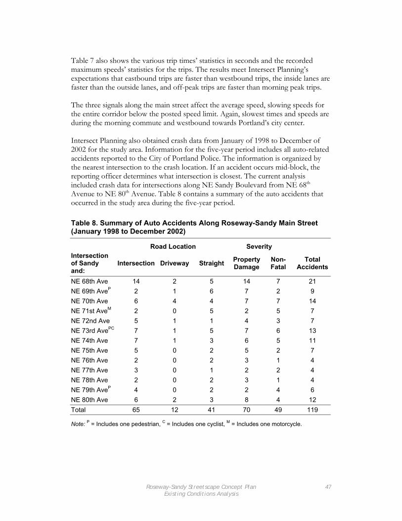
Roseway-Sandy Streetscape Concept Plan Existing Conditions Analysis
47
Table 7 also shows the various trip times’ statistics in seconds and the recorded maximum speeds’ statistics for the trips. The results meet Intersect Planning’s expectations that eastbound trips are faster than westbound trips, the inside lanes are faster than the outside lanes, and off-peak trips are faster than morning peak trips. The three signals along the main street affect the average speed, slowing speeds for the entire corridor below the posted speed limit. Again, slowest times and speeds are during the morning commute and westbound towards Portland’s city center. Intersect Planning also obtained crash data from January of 1998 to December of 2002 for the study area. Information for the five-year period includes all auto-related accidents reported to the City of Portland Police. The information is organized by the nearest intersection to the crash location. If an accident occurs mid-block, the reporting officer determines what intersection is closest. The current analysis included crash data for intersections along NE Sandy Boulevard from NE 68th Avenue to NE 80th Avenue. Table 8 contains a summary of the auto accidents that occurred in the study area during the five-year period. Table 8. Summary of Auto Accidents Along Roseway-Sandy Main Street (January 1998 to December 2002)
Road Location Severity Intersection of Sandy and:
Intersection Driveway Straight Property Damage
Non-Fatal
Total Accidents
NE 68th Ave 14 2 5 14 7 21 NE 69th AveP 2 1 6 7 2 9 NE 70th Ave 6 4 4 7 7 14 NE 71st AveM 2 0 5 2 5 7 NE 72nd Ave 5 1 1 4 3 7 NE 73rd AvePC 7 1 5 7 6 13 NE 74th Ave 7 1 3 6 5 11 NE 75th Ave 5 0 2 5 2 7 NE 76th Ave 2 0 2 3 1 4 NE 77th Ave 3 0 1 2 2 4 NE 78th Ave 2 0 2 3 1 4 NE 79th AveP 4 0 2 2 4 6 NE 80th Ave 6 2 3 8 4 12 Total 65 12 41 70 49 119
Note: P = Includes one pedestrian, C = Includes one cyclist, M = Includes one motorcycle.

Roseway-Sandy Streetscape Concept Plan Existing Conditions Analysis
48
The summary table provides information on the location and severity of accidents by intersection. Road location refers to the scene of the accident. Accidents that occur in the intersection typically involve turning movements and/or failures to obey traffic signals. Accidents that occur in driveways typically result from limited visibility and involve turning movements. Accidents that occur along the roadway straights between intersections typically involve rear-end collisions and/or conflicts between on-street parking and through traffic. The severity of an accident refers to the extent of bodily harm and property damage incurred during a crash. The Portland Police designate accident severity along three levels: property damage, non-fatal, and fatal. Accident severity is listed as property damage when a crash does not cause any bodily harm, but does involve damage to vehicles and/or physical structures. Accidents severity is listed as non-fatal when bodily harm occurs, but death does not. Accidents with a non-fatal designation likely include property damage as well. Finally, an accident designated as fatal involves the death of one or more parties involved in the crash. Fatal accidents almost always involve property damage and can involve non-fatal bodily harm as well. There were no fatal accidents in the study area during the five-year period. The accident data show that the most frequent accident location for motorists along Roseway-Sandy Main Street is around Sandy and NE 68th Avenue. Of the 21 accidents that occurred over the five-year period, two-thirds occurred in the intersection and one-third involved non-fatal bodily harm. The areas around the intersections of Sandy and NE 70th, NE 73rd, NE 74th, and NE 80th had a moderate number of accidents ranging from 11 to 14 for the five-year period. The majority of crashes occurred in the actual intersections with the fewest accidents occurring in driveways. The area with the most driveway crashes was near the intersection of Sandy and NE 70th Avenue. The crash information also provides information about the participants in an accident. The vast majority of accidents along the Roseway-Sandy Main Street involve only automobile drivers and passengers. Five of the reported accidents that occurred during the five-year period from 1998 to 2002 involved pedestrians, cyclists, or motorcyclists. As noted in Table 8, pedestrians were involved in three reported accidents. These accidents occurred at or near the intersections of Sandy Boulevard and NE 69th, NE 73rd, and NE 79th Avenues. All three of these accidents involved non-fatal bodily harm. The accidents at 69th and 79th Avenues occurred in the intersections and involved auto turning movements. The accident at 73rd occurred along a roadway straight with the cause designated as other. A cyclist was involved in one reported accident that occurred at in the intersection of Sandy and NE 73rd Avenue. The crash involved an auto turning movement and resulted in non-fatal bodily harm. One crash occurred involving a motorcycle along the roadway straight near the intersection of Sandy and NE 71st Avenue. The cause was attributed to the motorcyclist illegally overtaking an automobile and the result was non-fatal bodily harm

Roseway-Sandy Streetscape Concept Plan Existing Conditions Analysis
49
The analysis of crash information for the Roseway-Sandy Main Street from January 1998 to December 2002 resulted in the following findings: • The location and number of driveways should be studied further at and around the intersection of Sandy and NE 70th Avenue, and • The intersections of Sandy and NE 69th, NE 73rd, and NE 79th Avenues are dangerous for pedestrians.

Roseway-Sandy Streetscape Concept Plan Existing Conditions Analysis
50
3.4 Pedestrian Crossing Gaps A gap analysis helps to better understand the number of safe pedestrian crossings at unsignalized intersections. This type of analysis counts the number of times there is a clear crossing with no traffic that allows pedestrians to cross a street safely in a given amount of time. The standard elderly and children pedestrian travel speed is 3.5 feet per second. The vehicle right-of-way on upper Sandy Boulevard is 60 feet west of 77th Avenue and 54 feet wide east of 77th Avenue. Using these values, Intersect Planning determined that 17 seconds west of 77th Avenue and 15 seconds east of 77th Avenue is necessary for pedestrians to cross Sandy Boulevard safely. A gap analysis was performed for NE Sandy Boulevard on May 10, 2005 at three unsignalized intersections during the morning peak commuting time at 8:05 am. The data collection occurred for 20 minutes. The intersections in the analysis are Sandy Boulevard and 69th, 73rd, and 79th Avenues. Table 9 shows the results of the number of safe crossings in the twenty minutes, the number of safe crossings projected for an hour, and the average length of waiting time between safe crossing gaps. Table 9. Upper Sandy Gap Analysis
Intersection
Road Width (feet)
Safe Crossings in 20 minutes
Projected Safe Crossings in
an Hour
Average Waiting
Time (min:sec)
Sandy & NE 69th Ave 60 5 15 4:00
Sandy & NE 73rd Ave 60 6 18 3:20
Sandy & NE 79th Ave 54 10 30 2:00
The gap analysis shows that there are few safe crossings for pedestrians at non-signalized intersections without waiting for an extended amount of time. With long waiting times, pedestrians are more likely to take risks crossing the street when there are not large gaps in traffic. More risks are likely to result in more crashes. In order to decrease the chance of crashes, the Concept Plan includes many areas where the distance between curbs is decreased with the use of curb extensions and other amenities. These help reduce the crossing distance, decreasing the amount of time necessary to cross Sandy Boulevard. Also, the addition of a center median on portions of the Main Street creates a safe harbor for pedestrians after crossing one direction of traffic.

Roseway-Sandy Streetscape Concept Plan Existing Conditions Analysis
51
3.5 Transit Ridership As mentioned previously, NE Sandy Boulevard is designated as a major transit street. Such a designation mandates that plans for NE Sandy Boulevard consider the transit rider and other pedestrians. Accommodations should include buildings oriented to the street, entries oriented to the sidewalk and nearby bus stops, bus stop amenities (such as benches, trash cans, and shelters), and safe street crossings. There are currently twelve bus stops along Sandy Boulevard from NE 68th Avenue to NE 80th Avenue. While the spacing of bus stops does vary throughout the small corridor, there is an average of one bus stop every two blocks. The high ratio of bus stops to blocks shows that the Roseway-Sandy Main Street is well served by transit. The 12-Sandy bus, a frequent service bus, serves these bus stops when heading to downtown Portland westbound and Gresham eastbound. The high number of bus stops means crossing and stop improvements should applied in a selective manner. To do so in the Streetscape Plan, Intersect Planning analyzed boarding and alighting information for Spring of 2004 that was made available by TriMet. Table 10 shows the boardings and alightings for bus stops along NE Sandy Boulevard from NE 67th Avenue to NE 79th Avenue. Information is available for both the inbound and outbound directions and for a weekday, Saturday, and Sunday in March 2004. Analysis of the ridership information for bus stops serving the study area reveals that ridership is highest on weekdays and lowest on Sundays. When boardings and alightings are considered collectively, total activity is greater in the inbound direction than the outbound direction. The data also show that boardings are greatest for the inbound stops while alightings are greatest for outbound stops. This suggests that the majority of individuals using bus stops along the Roseway-Sandy Main Street are Roseway residents using the 12-Sandy bus for travel to the Hollywood District and/or downtown Portland. When individual stops are considered independently, the data demonstrate that the Sandy & 70th stops have the most overall activity. Interestingly, the Sandy and 70th outbound stop has over two times the boarding and alighting activity of any other outbound stop serving the study area. While Intersect Planning did not perform additional analyses to determine the explanations the high activity in the outbound direction, the most likely cause is the Safeway grocery store located on the north side of Sandy Boulevard at NE Sandy Boulevard. The Safeway is a major destination for residents of the surrounding areas.

Roseway-Sandy Streetscape Concept Plan Existing Conditions Analysis
52
Table 10. Daily Boardings and Alightings of 12-Sandy from March 2004 Bus Stop Direction Day Ons Offs Total
Weekday 5 43 48 Saturday 5 18 23 Sandy & 67th Outbound Sunday 4 15 19
Weekday 26 5 31 Saturday 13 5 18 Sandy & 67th Inbound Sunday 7 5 12
Weekday 83 35 118 Saturday 70 36 106 Sandy & 70th Inbound Sunday 39 29 68
Weekday 31 90 121 Saturday 30 69 99 Sandy & 70th Outbound Sunday 21 38 59
Weekday 33 46 79 Saturday 26 22 48 Sandy & Fremont Outbound Sunday 20 15 35
Weekday 74 29 103 Saturday 39 23 62 Sandy & Fremont Inbound Sunday 19 13 32
Weekday 20 16 36 Saturday 10 12 22 Sandy & 74th Inbound Sunday 5 6 11
Weekday 12 31 43 Saturday 7 16 23 Sandy & 74th Outbound Sunday 5 8 13
Weekday 5 29 34 Saturday 4 17 21 Sandy & 77th Outbound Sunday 2 12 14
Weekday 25 5 30 Saturday 19 5 24 Sandy & 77th Inbound Sunday 13 4 17
Weekday 7 36 43 Saturday 5 25 30 Sandy & 79th Outbound Sunday 2 18 20
Weekday 45 11 56 Saturday 29 7 36 Sandy & 79th Inbound Sunday 19 3 22
Note: Ons = Boardings, Offs = Alightings, Total = Sum of Boardings and Alightings.

Roseway-Sandy Streetscape Concept Plan Existing Conditions Analysis
53
The stops at Sandy and Fremont also enjoy a high level of boarding and alighting activity. Activity is highest in the inbound direction and boardings are considerably higher than alightings. This intersection also marks a transfer point for riders using both the 12-Sandy bus and the 33-Fremont bus. The data support the suggestions that the intersection of Sandy Boulevard, Fremont Street, and 72nd Boulevard is a major node in the Roseway Neighborhood and Northeast Portland. Total boarding and alighting activity at the remaining stops serving the study area are very similar with total activity ranging from 30 to 56 riders on weekdays and 11 to 36 on the weekends. When weekend alighting activity is considered to determine major destinations along the Roseway-Sandy Main Street, the data reveal that the Sandy and 79th outbound stop has a relatively high number of riders alighting on weekends. Intersect Planning has determined that the Gregory Heights Library is a major destination for transit riders. The library is across the street from the Sandy and 79th outbound stop. Thus, Analyses of the transit ridership information for the study area led Intersect Planning to the following findings: • Transit and pedestrian connections should receive extra consideration at and around Sandy and 70th, • Pedestrian amenities and street crossings should receive extra consideration at and near the Sandy and Fremont bus stops, and • The pedestrian crossing environment at Sandy and 79th warrants attention in any future street improvement efforts.

Roseway-Sandy Streetscape Concept Plan Existing Conditions Analysis
54
3.6 Zoning The map on the following page illustrates City of Portland zoning within a one-eighth mile buffer of NE Sandy Boulevard from NE 68th Street to NE 80th Street. The map illustrates the concentration of commercial zoning within one block of Sandy Boulevard. The vast majority of commercially zoned land is zoned General Commercial. Table 11 shows the acreage of commercially zoned land along this .71 mile section of NE Sandy Boulevard. Of all commercially zoned land in the analysis, nearly 99% is zoned General Commercial. General Commercial zoning is intended to allow auto-accommodating commercial development in areas already predominantly built in this manner. The zoning allows a full range of retail and service businesses with a local or regional market. Zoning code also mandates that land uses in a General Commercial zone adjacent to a transit street must accommodate pedestrians and other transit users. Table 11. Commercial Zoning along study section of NE Sandy Blvd (in acres)
Zone Total Area Percent of Commercial
CG 57.8 98.6%
CM 0.4 0.7%
CN2 0.4 0.7%
Total Commercial 58.6 100%
Note: CG = General Commercial; CM = Mixed Commercial; CN2 = Neighborhood Commercial 2.
Mixed Commercial/Residential and Neighborhood Commercial 2 zones comprise less than 1.5% of the commercially zoned land along the study corridor. According to local and regional definitions of main streets, mixed-use commercial development is a signature characteristic of vibrant main streets. Mixed Commercial/Residential zoning promotes development that combines commercial and housing uses on a single site and allows increased development on busier streets without fostering a strip commercial appearance. When designated more linearly, Mixed Commercial/Residential zoning supports transit and provides a buffer between busy streets and residential neighborhoods. Development is intended to be pedestrian-oriented with buildings close to and oriented to the sidewalk, especially at corners. Neighborhood Commercial 2 zoning is intended for small commercial sites and areas in or near less dense or developing residential neighborhoods. The emphasis in this zone is on uses which will provide services for the nearby residential areas and on other small-scale uses with little impact. When located adjacent to a transit street like

Zoning along R oseway Main S treet
0 430 860 1,290 1,720215F eet
P ortland Zoning
Open S pace
S ingle Dwelling R es idential 5,000
S ingle Dwelling R es idential 2,500
Low Dens ity Multi-Dwelling R es. 2,000
Medium Density Multi-Dwelling R es . 1,000
Neighborhood C ommercial 2
Mixed C ommercial
G eneral C ommercial
55

Roseway-Sandy Streetscape Concept Plan Existing Conditions Analysis
56
NE Sandy Boulevard, development is expected to accommodate the pedestrian and other transit user. Additional zones along the study corridor include: Open Space (OS); Medium Density Multi-Dwelling Residential w/ one unit per 1,000 square feet (R1); Low Density Multi-Dwelling Residential w/ one unit per 2,000 square feet (R2); Single Dwelling Residential w/ one unit per 2,500 square feet (R2.5); and Single Dwelling Residential w/ one unit per 5,000 square feet (R5). The study area lacks a concentration of higher density housing that typically accompanies and supports a regional main street. While transportation amenities will likely leverage land use changes along the Roseway-Sandy Main Street, zoning should be revisited to allow more desirable main street development and uses.

Roseway-Sandy Streetscape Concept Plan Community Visions and Values Analysis
57
IV. Community Visions and Values Analysis The Community Visions and Values Analysis describes the relevant community planning goals with supplemental community outreach engaging businesses, property owners, and residents. This is to better understand the context for main street design in the Roseway Neighborhood and Sandy Boulevard. The analysis includes a summary of the RNA Vision Plan, business surveys, and key informant interviews.

Roseway-Sandy Streetscape Concept Plan Community Visions and Values Analysis
58

Roseway-Sandy Streetscape Concept Plan Community Visions and Values Analysis
59
4.1 Roseway Neighborhood Vision Plan Summary Residents of the Roseway Neighborhood, acting through their neighborhood association, created a Vision Plan in 2002 that identified the immediate need to promote community appropriate development along their section of Sandy Boulevard. The Vision Plan successfully formed new relationships, set goals, and brought the notion of planning to the neighborhood’s agenda. The first section of the analysis summarizes the 2002 Roseway Neighborhood Vision Plan. The analysis is directed towards Sandy Boulevard and transportation-specific visioning and action items. The specified action items developed within the plan are summarized and used to inform the development of the business survey and key informant interviews. Findings In late 2000, the Roseway Neighborhood Association (RNA) initiated a citizen-driven visioning process for the Roseway Neighborhood. The RNA and a grant from the Meyer Memorial Trust provided funding for the grassroots planning effort. The process involved forming a Roseway Vision Steering Committee (RVSC) that worked closely with Urbsworks, the planning firm hired to produce the plan and to coordinate three interactive public workshops. The goals of the workshops were to clarify a general goal for the Roseway Neighborhood, designate focus areas, and identify actions and barriers to realizing the community’s vision. While the RNA approved the Vision Plan, it has not been adopted by the City of Portland. Focus Areas As a result of the public involvement workshops and the extended visioning process undertook by the RVSC, five focus areas were identified. The focus areas represent corridors and nodes that present the greatest opportunities for attaining the community’s goal of becoming more vibrant, walkable, and livable. The focus areas include: • NE Sandy Boulevard from 68th to 77th, • NE Sandy Boulevard from 77th to 82nd, • The intersections of Prescott and 72nd, Fremont and 62nd, and 82nd and Siskiyou. Each of the focus areas is mainly commercial in nature and the workshop participants, primarily residents, expressed satisfaction with the residential areas of the neighborhood. Vision Elements of NE Sandy Boulevard from 68th to 77th Of particular importance for the Concept Plan are the general opinions, existing conditions, action items, and perceived barriers for the first focus area: NE Sandy from 68th to 77th. Residents involved in the visioning workshops identified Sandy from 68th to 77th as the neighborhood’s geographic, civic, and commercial center.

Roseway-Sandy Streetscape Concept Plan Community Visions and Values Analysis
60
The community foresees a lively pedestrian-oriented commercial main street centered at the intersection of Sandy, 72nd, and Fremont. Workshop participants envisioned wide sidewalks, improved bus stops, curb extensions, street trees, improved and more frequent pedestrian crossings, and more frequent traffic lights. The vision includes slower traffic speeds with better signal timing to maintain the flow of traffic moving through the neighborhood. Community members also expressed a strong desire to strengthen the connection between the center of the Roseway Neighborhood with its namesake, the Roseway Parkway along 72nd from Sandy to Prescott. Additional aspects of the end result for Sandy between 68th and 77th involve the current and future businesses that line the commercial strip. Residents of Roseway envisioned existing businesses taking advantage of storefront loans and improving the appearance of aging commercial buildings. The vision also includes a mix of businesses with a variety of goods, customers, and hours of operation. Participants in the community workshops expressed a desire for the Southeast Asian business community to become even stronger. Residents also envisioned new construction along this section of Sandy being mixed use with commercial uses at street level and residential uses above street level. Finally, the goal for the first focus area includes a parking plan that includes maximizing the utility of on-street parking and consolidating off-street parking to centrally located surface lots off of Sandy. Action Items The RVSC worked with Urbsworks to develop specific action items based upon the input provided by residents at the three workshops. The action items for Sandy from 68th to 77th that are relevant for the current plan are included in Table 12 with implementers and a timeframe for each. The RVSC and the RNA have stated that the neighborhood’s process is an ongoing and fluid process. As such, the Roseway Vision Plan is intended to be a working document. The need has been identified to integrate the Roseway vision into ongoing and future city and regional planning efforts. The RVSC has approached the neighborhood’s vision by providing individual action items for each facet of improving Sandy from 68th to 77th. Improvements envisioned by the residents include streetscape improvements, building improvements, zoning changes, community building, and transportation policy changes. The current plan addresses streetscape improvements and transportation policy changes in a comprehensive manner to ensure coherency and inclusiveness with the prior Roseway Vision Plan.

Roseway-Sandy Streetscape Concept Plan Community Visions and Values Analysis
61
Despite an ambitious timeframe identified in the Vision Plan, the action items have yet to be implemented. Table 12. Roseway Vision Plan Transportation Related Action Items
Action Implementer(s) Timeframe (years)
Work with local businesses to get trashcans at neighborhood bus stops. TriMet, RNA, RBA 1
Explore installing planters on medians as a short-term improvement. RNA 1
Adjust light timing to favor pedestrians, with longer crossing time and quicker change to “walk” signal.
PDOT 1
Design and install banners, street furnishings and plants to build a better business district.
RBA 2
Improve and install new street crossings. PDOT, RNA, RBA 2-5
Establish business district tree planting. Friends of Trees, RBA 2
Organize park block design workshop. RNA, RBA 2
Select, design and prioritize on-street parking revisions. RBA, PDOT 2
Implement selected on-street parking revisions. OPDR, PDOT 2
Negotiate parking at the existing surface lots for use by local business customers.
Commissioners, RBA 2
Implement park block design. RNA, RBA >5
Reclassify Sandy as a “Main Street” through this area. PDOT 1
Study, design, and implement improvements to 72nd/Sandy intersection.
PDOT 5
Update Bicycle Master Plan to show 72nd/Fremont/Sandy as a junction of several routes. Implement improvements.
PDOT 1-2, >5

Roseway-Sandy Streetscape Concept Plan Community Visions and Values Analysis
62
Update Pedestrian Master Plan to show junction of several routes. Implement improvements.
PDOT 1-2, >5
Rezone. OPDR, BOP 2
Coordinate bus stop improvements. TriMet 2
Improve local bus services, especially for commuters, weekend and evening users of lines 12 and 33.
TriMet 2
Coordinate weekend use of Park and Ride spaces for business customers.
TriMet, RBA, commissioners 2
Explore streetcar on Sandy TriMet, PDOT >5
Create and negotiate shared parking program utilizing existing surface parking lots for use by local business customers.
RBA, PDC, TriMet 2
Secure storefront improvement loan funding. RBA, PDC 2
NOTE: RNA = Roseway Neighborhood Association, RBA = Roseway Business Association, PDOT = Portland Office of Transportation, OPDR = Office of Planning & Development Review, PDC = Portland Development Commission

Roseway-Sandy Streetscape Concept Plan Community Visions and Values Analysis
63
4.2 Sandy Boulevard Business Survey Summary The Vision Plan successfully mobilized residents to participate in the visioning process. The business survey builds on that success by reaching out and engaging other important groups in the area, most notably, the various and distinct business and property owners along Sandy Boulevard. Changes to the transportation infrastructure, as conceived in the Concept Plan, would greatly impact these groups. Substantial levels of participation and input into the planning process from all parties are needed to inform future recommendations and changes. A specific objective of the concept planning process was to provide additional outreach to the Sandy Boulevard business community. The business survey targeted all businesses in the study area along Sandy Boulevard from 68th to 80th. The survey dealt with two main project objectives. First, the survey allowed businesses to respond to Sandy Boulevard and transportation- related action items in the Vision Plan. Second, the survey also provided a brief opportunity for them to articulate their vision for Sandy Boulevard. A special focus of the business survey addressed the need to make additional outreach with the large cluster of Southeast Asian owned, operated, and oriented businesses along Sandy Boulevard. Residents and business representatives had identified the value of these businesses to the area. The high degree of consolidation of these businesses along the study section compounded with their limited participation in other outreach efforts makes them an integral and important group to include in the planning process. Methods The survey instrument consisted of a set of Likert-scaled questions that asked respondents to determine how much they agree or disagree with certain action items identified in the Vision Plan. Additional open-ended questions asked respondents to envision how they would like Sandy Boulevard to develop and what areas in Portland they would like to see Sandy Boulevard resemble. A set of background questions assessed the business’ relationship to the area. A copy of the survey tool is attached in Appendix B. Sixty businesses and organizations (i.e. churches and civic institutions) were identified for surveys and represent all such businesses and organization in the study area. Project staff conducted all surveys during a two-week period in April 2005 with some limited follow-up in May; all participants were properly appraised of the survey’s purpose and assured of the confidentiality of their responses. Since the majority of businesses along Sandy Boulevard are owner-operated, the business owner was surveyed. In the few cases where an owner was not available, a business manager served as a proxy. Surveys were completed in-person except in the handful of cases where the appropriate respondent was not available to answer questions; in those cases, the survey was left with directions and consent information with a self-

Roseway-Sandy Streetscape Concept Plan Community Visions and Values Analysis
64
addressed, stamped envelope for return. Staff members took additional notes on transportation and planning issues that respondents offered during the survey. Findings Seventy-five percent of all businesses along Sandy Boulevard between NE 68th and NE 80th responded to the survey. Generally, most businesses are small, owner-operated establishments that lease the building space that they occupy. However, a significant number of businesses own these spaces. Table 13 summarizes some background respondent characteristics collected in the survey. Seventy-three percent of businesses report that they have been at their current location for over five years. Approximately one in three respondents reside within the neighborhood. The businesses along the study area serve a wide variety of patrons, with over half of them coming from places within the greater Metro region. Regardless, many of the businesses primarily serve the immediate community. Thirty-seven percent of businesses say that the majority of their customers come from within two miles of the business. Business owners report that a large proportion of business comes from community members seeking to either use the services they offer or fulfill their desire to support local, small businesses. Table 13. Selected Background Characteristics of Survey Respondents Lease or own space: 23% Own 73% Lease
Reside at current location: 5 % <1 year 23% 1-5 years 73% >5 years
Home Residence: 27% in neighborhood 70% outside neighborhood
Majority Patrons come from: 9% < than a mile 28% 1-2 miles 56% > 2 miles
Sample Size: 45 of 60 (75%) Table 14 presents participants’ survey responses to action items identified in the Vision Plan. In general, businesses view most transportation improvements favorably, expressing the general need to upgrade current facilities to address the pedestrian and aesthetic qualities of the area. Responses and opinions are far from uniform. The responses are summarized below in four thematic components: pedestrian and bicycle elements, parking, traffic and intersection considerations, and identity features. Pedestrian and Bicycle Elements Businesses consistently agree with the idea that sidewalk amenities targeting the pedestrian environment would benefit their business. Three-quarters of the responses viewed improvements in sidewalk amenities, such as trees, benches, and trashcans, as having a beneficial impact on their business. Respondents were most

Roseway-Sandy Streetscape Concept Plan Community Visions and Values Analysis
65
keen on the addition of street trees, citing that Sandy’s current streetscape lacks trees and greenery. Businesses agreed with resident perceptions that Sandy is not a pedestrian-friendly area and that better street crossings are an immediate need in the terms of both quantity and quality. Bicycle improvements were also viewed positively with 54% favoring some action. However, these improvements were viewed less enthusiastically with only 14% strongly agreeing with the idea. Additionally, many business owners suggested that lighting improvements help address the perception that the area is unsafe at night, as well as create a more inviting nighttime environment. Parking Transportation improvements that impact parking availability are a major concern to businesses. While reliance on parking is evident, businesses seem flexible to parking options other than strictly relying on on-street parking. The majority (52%) of businesses say that they rely on on-street parking. Those that do not, however, have their own parking lots or do not rely on parking as the sole means of accessing their business. Businesses viewed reductions to on street parking as harmful to their business. Many businesses noted that presently they enjoy excess capacity of parking along Sandy and the adjacent residential streets. Businesses were receptive to the idea of using shared surface parking lots for their patrons and most did not view current on-street parking restrictions as a problem. Transit Businesses were asked about the number and quality of transit stops in survey. In general, transit elements were viewed as adequate in terms of the number of stops or the condition of the stops. Some respondents viewed graffiti and vandalism at stops as a problem to the overall look of the area but that overall maintenance is usually good. A few business owners expressed a desire to see other forms of fixed rail transit extended to the area, such as a line from the Portland Streetcar running up and down Sandy. Intersections and Turning movements The Vision Plan identified the need to address the intersection of Sandy, Fremont, and 72nd, the primary focus area and center of the business district. Businesses unanimously concurred with residents that the intersection needs improvement. Additionally, businesses cited the need to address turning movements off Sandy Boulevard, saying that making left hand turns is difficult. Paradoxically, many business owners found themselves appreciating the assumed business advantage of large traffic volumes and faster travel speeds that allow better exposure and access; however, they also were found to want better pedestrian qualities and safety.

Roseway-Sandy Streetscape Concept Plan Community Visions and Values Analysis
66
Identity Features The survey included two questions directed towards the overall cohesiveness of the business district in terms of identity and whether certain identity features would be appropriate. Businesses were mixed on the idea that the business district had a strong identity with respondents presenting polarized views on the subject. Some businesses, particularly the Vietnamese oriented, felt that the identity was strong and easily identified, while others expressed feeling deeply disconnected to other businesses in the area. Businesses were generally receptive to using identity features like banners and signs to create a more readily distinctive identity for the area. Future Character on Sandy Respondents were asked to provide information on how they would like to see Sandy develop in the future by selecting existing areas in the Portland metro area as approximations. The visioning questions were not well answered by respondents with only one in five offering suggestions. Those that did respond most commonly identified with business districts along Broadway and Fremont Avenues in NE Portland, the Hollywood District on lower Sandy Boulevard, and Hawthorne and Tacoma Avenues in SE Portland. In citing these areas, businesses expressed that they wanted Sandy to have a vibrant business district that would be a destination place for shoppers and customers. These areas were places that they thought had calmer street traffic, a better pedestrian environment that encouraged personal interaction and shopping, a stronger business district identity, and better visual appearance and maintenance. Table 14. Responses to Potential Transportation Changes to Sandy Blvd. Strongly
Agree Agree Neither
Agree nor Disagree
Disagree Strongly Disagree
The addition of trees, benches, and flower boxes would improve the sidewalk area in front of this business
47% 23% 14% 14% 2%
Safer pedestrian street crossings are needed
53% 21% 21% 5% 0%
More marked pedestrian street crossings are needed
30% 30% 19% 21% 0%
Improvements for bicycle riders are needed
14% 40% 33% 9% 5%
This business relies primarily on on-street parking
41% 11% 7% 27% 14%
Reductions in on-street parking would harm this business
50% 14% 11% 18% 7%

Roseway-Sandy Streetscape Concept Plan Community Visions and Values Analysis
67
Shared surface parking lots off of Sandy Boulevard for customers would benefit businesses
30% 37% 21% 9% 2%
On-street parking restrictions (like 2-hour limits) need to be revised to increase parking availability
9% 28% 33% 26% 5%
The intersection of NE 72nd and Sandy Boulevard needs to be improved
57% 27% 16% 0% 0%
There is an adequate number of bus stops
23% 49% 28% 0% 0%
Improvements to bus stops are needed
7% 17% 60% 14% 2%
It is difficult to make left hand turns off Sandy Boulevard
33% 44% 19% 5% 0%
The business community has a strong identity
14% 42% 19% 12% 14%
Banners and signs would help create a more visible business district
28% 47% 21% 2% 2%

Roseway-Sandy Streetscape Concept Plan Community Visions and Values Analysis
68
4.3 Key Informant Interviews Summary The third section of the analysis is a summary of key informant interviews conducted with three community groups: 1) Residents of the Roseway neighborhood; 2) Business and property owners along Sandy Boulevard; and, 3) Civic organizations and special populations within the Roseway Neighborhood (e.g. community library, school-aged children, older persons). The key informant interviews consist of a collection of semi-structured conversations with eleven key neighborhood residents, business and property owners, and other stakeholders to explore the range of issues related to transportation investment and Main Street development in the Roseway Neighborhood. The interviews were designed to further inform the community visioning, especially in understanding how specific values and visions may respond to- or feed into changes in the transportation system. Parallel to the business survey, the informant interviews focused on the diverse set of parties that have a stake in the area. Specific attention was directed at understanding how the Southeast Asian business owners view their relationship with the neighborhood, other businesses, and the transportation environment. The interview consisted of ten open-ended questions that asked participants to describe various elements of their neighborhood. Specifically, the project sought to understand the participant’s relationship to the Roseway Neighborhood and their perceptions of: • The Roseway Neighborhood • Sandy Boulevard • Main Street Concept • The current transportation problems on Sandy Boulevard • Transportation improvements in addressing community main street goals
The interview questions were designed to gather this information. Follow-up prompts were used to probe interview responses for more detailed information. A copy of the interview tool is attached in Appendix C. Methods The project staff, working with the Land Use Committee of the Roseway Neighborhood Association, developed a list of participants that could be consulted with during the planning process. This list was parsed into three groups that shared similar characteristics: residents, business and property owners, and special populations and organizations. Interviewee selection was guided by the need to select a diverse set of individuals that could speak broadly to a range of issues.

Roseway-Sandy Streetscape Concept Plan Community Visions and Values Analysis
69
Prospective participants were contacted and presented with the interview’s purpose and consented to participate. An interview was scheduled with the participant either in-person or over the telephone. A project staff member conducted the interview and took detailed notes of the conversation; interviews were not tape-recorded. Interviews ranged in length from thirty to sixty minutes. Findings This section summarizes a series of interviews conducted with key informants in the Roseway Neighborhood regarding transportation improvements along Sandy Boulevard. The findings are divided among three broad interest groups identified during the key informant selection process. Residents Interviewed residents were middle- to older-aged and lived in the neighborhood from ten to sixty years. All have been active in the community through civic organizations or have served on the board of RNA and have a keen interest in the future of the Roseway neighborhood. Roseway Neighborhood and Sandy Boulevard Residents uniformly viewed the neighborhood as going through a period of moderate to intense change. Many of the traditional, older, “blue collar”, working families are perceived to be giving way to younger, professional couples buying their first homes. A significant number of homes in the area have undergone renovations interpreted as a small “renaissance” for the community. The change in the physical appearance of homes and the resultant neighborhood character were perceived to be improvements for the neighborhood. Ultimately, all interviewed residents feel that the Roseway Neighborhood is a “diamond in the rough,” with the area showing great promise for future development. The perceived increased frequency of families with children in the neighborhood signified that the area was losing its stigma of high crime and prostitution activity. Residents expressed disappointment with Sandy Boulevard’s longtime association with prostitution and other related property crimes. The presence of adult businesses in the area continues to be a sensitive issue as residents articulated concerns that the area’s orientation towards these businesses creates a disincentive for more “family-friendly” businesses to locate in the area. However, they did express some degree of optimism that the area is getting better with the recent closing of two adult businesses along Sandy Boulevard. Residents addressed several aspects relating to transportation and land use. Residents feel that currently Sandy Boulevard is not a place “anyone would want to walk around” even if there were destinations. They felt the need to change the perception that Sandy Boulevard is a “freeway,” since motorists use Sandy Boulevard as a
Roseway-Sandy Streetscape Concept Plan Community Visions and Values Analysis
70
through street to go to other places besides the Roseway. They would like to see a place that offers a mix of services that “draw people at night,” signifying it as a place that is vibrant and lively. Residents felt that Sandy does not currently have the mix of businesses necessary to make it a community destination. By “mix” of businesses, residents stated a preference for establishments like restaurants, retail shops, coffee shops, and brewery pubs. Transportation Issues While all respondents were familiar with the neighborhood Vision Plan identifying Sandy Boulevard as the community’s main street, they expressed differing views and concerns as to whether Sandy could overcome “major problems” and realize its designation as the center of the neighborhood. In general, interviewed residents find Sandy Boulevard “hostile” to pedestrians due, in part, to its “highway feel.” The study section of Sandy is described as an unpleasant place to walk around by the interviewees. Specifically, they cited several issues related to the pedestrian environment: • The lack of sidewalk amenities, such as trees, benches, and medians, fail to
create a green streetscape and comfortable walking environment • The lack of trash cans on Sandy Boulevard could help address the trash on the
sidewalk problems • The poor condition of pedestrians crossing markings makes it difficult for
motorists to gauge where pedestrian cross and creates safety problems • Inconsistent curb-ramps make it difficult for bike riders to cross intersections • Crosswalk signal timings were perceived to be very short and do not allow a
reasonable time period for a person to safely cross the street • The large scale of the Sandy, Fremont, and 72nd intersection makes it difficult
to get from one side of the street to the other • The poor physical condition and inconsistent quality of the sidewalk contributes
to the poor aesthetic quality of the area. • Driveways accessing Sandy Boulevard make walking along sidewalks unsafe. The
driveway at Safeway onto Sandy Boulevard was cited as particularly problematic. • Right-hand turns at 77th allow high speed turns onto residential streets. Residents described traffic and transit elements. They include: • The large scale and non-perpendicular approach angles to the Sandy, Fremont,
and 72nd intersection makes turning movements difficult and confusing, posing safety concerns for motorists and pedestrians.
• The need to slow traffic along Sandy and create a more comfortable pedestrian environment
• Traffic is loud and a nuisance • The quality of transit stops could be improved, however, these sentiments were
borne out with issues of vandalism and the lack of trash cans

Roseway-Sandy Streetscape Concept Plan Community Visions and Values Analysis
71
• Underutilized parking lots with driveways on Sandy Boulevard make the area seem uninviting and generally do not reflect an area that is alive and well.
Business and Property Owners Three current business owners and a property owner along Sandy Boulevard were interviewed to better understand their relationship to the Roseway neighborhood and their interests in transportation improvements. The property owner has developed several buildings, whose spaces are leased. The businesses offer a range of services and retail. As a primary objective of the key informant interviews, a representative of the Southeast Asian businesses along Sandy was interviewed. Only one of the owners lives in the neighborhood. Roseway Neighborhood and Sandy Boulevard Business owners felt that their businesses served the immediate Roseway area as well as the greater Northeast Portland area. Business and property owners say they enjoy Sandy’s advantage in terms of volumes of drive-through traffic that provide exposure and easy access for customers. Sandy’s uniqueness as a major diagonal arterial with direct access to downtown made it an attractive place to locate a business – a couple of owners think that the non-perpendicular streets are “very interesting” and attract customers. All the business owners said they tried to frequent the other small businesses in the area as a measure of support. A business owner said he feels “kinship” with all the other businesses knowing that they feel the similar pressures to make their businesses succeed in the area. Business owners disagreed on the strength of the business district’s identity. The Vietnamese business owner considered the identity very strong citing the high degree of Vietnamese business consolidation along Sandy Boulevard. The consolidation of the businesses present Sandy as a regional destination for all persons seeking Vietnamese oriented services and retail. However, the Vietnamese business owner admitted that he does not feel connected with other non-Vietnamese businesses in the area. The other two businesses expressed a frustration over past attempts to create a business association and that one without participation from the Vietnamese business would not have legitimate standing. They felt that those efforts were less than successful due to poor participation by the Vietnamese businesses in the fledgling efforts of the association. Further conversations with the Vietnamese business owner revealed that poor participation is most likely due to three reasons. First, many of the businesses are owned and operated by persons who are unfamiliar with the normative expectations of participation within a business association. Second, many owners work long hours with heavy responsibilities loads and either are loathe to take on additional duties or do not see the direct benefits of participation. Third, differences in cultural norms and values create barriers in establishing strong lines of communication and general
Roseway-Sandy Streetscape Concept Plan Community Visions and Values Analysis
72
trust. Interestingly, the Vietnamese business owner expressed enthusiasm for future outreach efforts for a business association. Business and property owners expressed doubt that Sandy can attain the main street character that they envision. Owners consistently described a main street as a place where people are out walking and shopping. They felt that a comfortable and well-maintained pedestrian environment is a critical element for a successful main street. They feel disadvantaged in this regard when they compare themselves to other main streets in the Portland area. Specifically, owners like the physical look of other districts like SE Hawthorne, NE Broadway, NE Fremont, and Martin Luther King Drive north of Broadway. They felt these areas were able to maintain high levels of traffic without congestion; they were able to maintain on-street parking since it is the “life-blood” of a small business; and, the areas were seen as safe, visually appealing, and clean for shoppers. They feel there are large disparities between those main streets and Sandy Boulevard. Sandy was described as “not clean,” “barren,” “ugly,” “unsafe,” a “freeway,” and “neglected.” Transportation Issues Business and property owners suggested several transportation issues that needed to be addressed. The pedestrian elements and parking elements are described below. • The lack of street trees makes the area in front of businesses look unappealing • The lack of trash bins could help address the cleanliness of the sidewalks in front
of businesses • Current street crossings are perceived to be unsafe for pedestrians • Crossing the intersection of Sandy, Fremont, and 72nd takes too much time and
better pedestrian crossings are needed • General safety is a concern: better, distinctive lighting could make it more visible
and appealing for the business district • Median refuges are inadequate for pedestrians and need to be improved • Maintain on-street parking availability and provide better buffers for parkers
from vehicle traffic on Sandy Owners also suggested several traffic considerations that need attention. • Vehicles travel at high speeds, creating comfort concerns for shoppers exiting
cars parked on Sandy Boulevard, necessitating the traffic calming measures • Turning left off Sandy Boulevard is difficult and limits access to businesses
compelling improvements to left hand turning movement • Turning and other allowed movements at the intersection of Sandy, Fremont,
and 72nd are difficult to understand, necessitating clearer street signage • Physical condition of the street is poor and needs repair

Roseway-Sandy Streetscape Concept Plan Community Visions and Values Analysis
73
Special Populations Sandy Boulevard is home to populations and uses that require special considerations in transportation planning. An apartment complex for older persons is located at NE 69th and Sandy, and a new construction with senior housing is being built at NE 82nd and Sandy Boulevard. Gregory Heights Middle School is located three blocks south of Sandy Boulevard on Siskiyou; Harvey Scott Elementary is located six blocks north of Sandy on Prescott and NE 68th; and Madison High School is located on NE 82nd and Alameda. The Roseway branch of the Multnomah County Public Library is within the study area, located at 79th and Sandy Boulevard. Together, these different populations and uses force the consideration of how the transportation improvements would affect them. The key informant interviews targeted representatives from the senior apartment building, Gregory Heights Middle School, and Multnomah County Public Library. All representatives live and work in the Roseway neighborhood. Sandy Boulevard The primary focus of conversations with representatives from the senior apartment building, Gregory Heights Middle School, and Multnomah County Public Library centered on the transportation considerations of each group to Sandy Boulevard. All representatives feel that the pedestrian environment is both unsafe and undesirable. The school representative stated that children have difficulty with walking to school. Specifically, crossing Sandy is a significant barrier in terms of safety encountered by students. So much so that children actively avoid crossing Sandy and “ride with their parents hours before schools open” or “take taxis” to school to avoid crossing Sandy Boulevard. Teachers and the school PTA have deliberately avoided endorsing a “walk to school week” because of perceptions that they would be putting students at risk by encouraging them to cross Sandy Boulevard. The library representative voiced similar safety concerns with many students walking from the middle and high schools to the library. The representatives felt that crossings are unsafe and difficult because signals are timed too short for students to cross, or are not placed at the appropriate routes that students take to school. They also felt that special considerations should be made to make crossings as safe as possible for students, since they are not as aware or as visible to motorists compared to adult pedestrians. The representative from the senior apartment residence shared many of the same concerns for seniors as those related to students. Long crossing distances and short crossing times at pedestrian signals create difficult pedestrian crossings for older persons who do not walk as fast as younger persons. The representative stated that many residents travel to other business districts in Portland for their walks and exercise. The poor pedestrian environment and lack of benches discourage residents from venturing out to the community along Sandy Boulevard.

Roseway-Sandy Streetscape Concept Plan Community Visions and Values Analysis
74
Transportation Issues In general, interviewed representatives find Sandy Boulevard unsafe and difficult to maneuver for younger and older persons: • Current street crossings are perceived to be unsafe for younger and older person
who need more time and other special considerations in their crossing movements
• Pedestrian signals at the intersection of Sandy, Fremont, and 72nd are timed too short for safe pedestrian crossings
• The lack of sidewalk benches discourages walking along Sandy for older persons needing a reprieve
• Consistent and high-quality curb-ramps are needed for seniors with mobility restrictions and students traveling by bicycle
• Right-hand turns at 77th, across from the library, allow high speed turns onto residential streets, posing crossing safety concerns.

Roseway-Sandy Streetscape Concept Plan Portland Main Street Case Study Analysis and Main Street Transportation Solutions Toolbox
75
V. Portland Main Street Case Study Analysis and Main Street Transportation Solutions Toolbox
The Portland Main Street Case Study Analysis reviews other Portland area Main Streets Plans and discusses the relevant issues for the concept planning process. The creation of a Main Street Transportation Solutions Toolbox presents transportation improvements identified in the Case Study Analysis and other transportation planning literature to address potential problems in the transportation environment.

Roseway-Sandy Streetscape Concept Plan Portland Main Street Case Study Analysis and Main Street Transportation Solutions Toolbox
76

Roseway-Sandy Streetscape Concept Plan Portland Main Street Case Study Analysis and Main Street Transportation Solutions Toolbox
77
5.1 Portland Main Street Case Study Analysis Metro’s 2040 Growth Concept includes Main Streets as a target area to improve transportation facilities and to leverage Main Street development. Due to the regional need, the City of Portland has developed several Main Street plans in the region. Through discussions with members of the Technical Advisory Committee (TAC) and the client, Intersect Planning identified several criteria for the selection of Main Streets to include in the case study analysis. The Main Streets had to:
1. Be within the Portland-metro region, 2. Have existing plans completed for the Portland Department of
Transportation, 3. Have existing attributes such as traffic volumes or roadway configuration
similar to Sandy Boulevard through the Roseway neighborhood, and 4. Have adopted plans and be various stages of implementation.
The plans selected for review were: Foster Road Transportation and Streetscape Plan, the Woodstock Boulevard Pedestrian Plan, the Tacoma Main Street Plan, and the Hawthorne Boulevard Transportation Plan Findings There are a number of similarities among the Foster Road Transportation and Streetscape Plan, the Woodstock Boulevard Pedestrian Plan, the Tacoma Main Street Plan, the Hawthorne Boulevard Transportation Plan and our own planning efforts in the Roseway neighborhood along Sandy Boulevard. All of the plans address a well-traveled corridor in the city of Portland that received main street designation within the Metro 2040 Growth Concept. Furthermore, all of the plans reviewed are concerned with enhancing the streetscape and pedestrian environment using transportation funding, a major goal of the Roseway Main Street Concept Plan. Further analysis of the plans and their impact on the Roseway Main Street Concept Plan follows. The Goals and Objectives established for three of the four plans reviewed resonate with the goals and objectives identified for the Roseway-Sandy Streetscape Concept Plan. The Hawthorne Boulevard Plan did not contain any explicit statements regarding the plan’s goals and objectives. However, a sampling of the goals identified in the other three plans include:
• Make the street a safe, pleasant, attractive, and comfortable place to walk (Foster Road Plan),
• Provide opportunities for pedestrians to safely cross Woodstock Boulevard (Woodstock Pedestrian Plan),

Roseway-Sandy Streetscape Concept Plan Portland Main Street Case Study Analysis and Main Street Transportation Solutions Toolbox
78
• Create a high quality pedestrian oriented street (Tacoma Main Street Plan), • Enhance the neighborhood business district through additional landscaping
and street furniture (Woodstock), • Reduce the barrier effect of Tacoma Street - which divides the neighborhood
(Tacoma), and • Create a safe walking environment for pedestrians walking along and across
the street (Foster). In addressing these goals and objectives, all of the plans used similar tools and techniques, influencing the development of the Roseway Main Street Concept Plan toolbox found at the end of this chapter. The organization of all four plans is similar and provides additional rationale for the proposed arrangement of the Roseway Main Street Concept Plan. In the “Overview of the Planning Process”, the Foster Road Transportation and Streetscape Plan identifies three phases of the planning process. The first phase included an existing conditions analysis, identification of opportunities and constraints, and formulation of the project goals. The second phase looked at a range of conceptual alternatives for the streetscape, and the third phase was a refinement of the preferred alternative and the development of design details. The Woodstock, Tacoma, and Hawthorne Plans, as well as our own Roseway Main Street Concept, all address the first two phases as described in the Foster Road plan, while the Foster Road plan outlines phase three and the preferred alternative that was chosen at the end of phase two. In examining alternatives for the right-of-way, the Woodstock Boulevard Pedestrian Plan highlighted four main alternatives, with additional variations in two of those alternatives, for a total of six alternatives analyzed. The Tacoma Main Street Plan examines even more alternatives, as the street was broken up into segments, and multiple alternatives examined for each segment. The Hawthorne Boulevard Plan examined five alternatives that were laid out as an iterative group of ideas, that is, each alternative built upon the previous one. The preferred streetscape presented in the Foster Road plan was derived from three main alternatives that were presented to the community. Zoning on Main Streets The four main streets used in the case studies vary in terms of land use zoning. Parallel to the Roseway-Sandy Streetscape Concept Plan, 12 block-long zoning focus areas were selected from the four case studies. All focus areas are within the respective Plan’s boundaries. Woodstock and Hawthorne is zoned at least 75 percent Storefront Commercial. This type of zoning is preferable for a Main Street development because it places commercial properties adjacent to the sidewalk. Woodstock also has four blocks that
Roseway-Sandy Streetscape Concept Plan Portland Main Street Case Study Analysis and Main Street Transportation Solutions Toolbox
79
include Neighborhood Commercial and Medium Density Dwelling zoning. Other than Storefront Commercial, Hawthorne also has Medium Density Dwelling zones. Foster is completely zoned as General Commercial and more than 85 percent of Sandy Boulevard in the study section is zoned General Commercial. This type of commercial development zoning is less than ideal on a main street since it primarily accommodates auto-oriented businesses. On Sandy, this is due to the Boulevard’s history as a state highway. The rest of the Roseway-Sandy Streetscape Concept Plan area has 1.25 blocks of Medium Density Dwelling zoning and a quarter of a block zoned Neighborhood Commercial. Tacoma Street is unique in comparison to the other main streets’ zoning because it has a variety of zoned uses divided almost equally along the main street stretch. These uses include: Storefront Commercial, General Commercial, Single Dwelling, Low and Medium Density Dwellings, and Mixed Commercial.

Roseway-Sandy Streetscape Concept Plan Portland Main Street Case Study Analysis and Main Street Transportation Solutions Toolbox
80
5.2 Main Street Solutions Toolbox The Main Street Toolbox consists of tools and techniques for public right-of-way improvements and is included for use by the Roseway Neighborhood in further clarifying their main street vision. Various sources of literature were utilized in creating the Toolbox, including existing main street handbook documents and the four plans used in the main street case study. Included in the Toolbox are four subsections that relate to different types of main street developments: Pedestrian Safety Improvements, Sidewalk Amenities Improvements, Bicycle Improvements, and Vehicle Travel Improvements. Each subsection in the Toolbox presents techniques for creating a more livable and thriving main street environment. Successful main streets are areas where pedestrians feel comfortable walking and they are safe from the street’s vehicular and bicycle traffic. Safety improvements in the pedestrian realm help secure crossings for pedestrians as well as increase the buffer size between people walking on the sidewalk and the street’s vehicles. These types of developments also help provide pedestrians easier access to businesses on the main street. Sidewalk amenities help make main streets a more habitable space. They are included to provide pedestrians and patrons of main streets places to stop and rest, talk with others, and to help beautify the area. Bicycle improvements are important for main streets because they make bicycling easier and safer on or near the main street. The most successful main streets provide safe access for multimodal transportation, including by bike. Lastly, improvements to the vehicle right-of-way are critical for successful main streets. These include developments that slow traffic for the safety of pedestrians and bicyclists and also those that help give main street districts a unique identity. Using the Toolbox Many of the amenities and solutions in the Toolbox are applied within the Roseway-Sandy Streetscape Concept Plan’s focus areas. Not all Toolbox improvements are contained in the Concept Plan; because not all elements work well together. The Toolbox represents a range of solutions applied to selected transportation problems in Roseway-Sandy Streetscape Concept Plan; however, it shows only one view of the possible combinations of solutions. The Main Street Transportation Solutions Toolbox was produced using a variety of technical Main Street documents from the US and worldwide. Sources were compiled from recommendations by the TAC, as well as, through other search methods. All sources are included in the Toolbox for reference. An explanation, guidelines, sources for information, and pictures are included for each item. The Toolbox is included in Appendix A.

Roseway-Sandy Streetscape Concept Plan Appendix A. Main Street Solutions Toolbox
81
Appendix A. Main Street Transportation Solutions Toolbox

Roseway-Sandy Streetscape Concept Plan Appendix A. Main Street Solutions Toolbox
82

Roseway-Sandy Streetscape Concept Plan Appendix A. Main Street Solutions Toolbox
83
Pedestrian Safety Improvements
Improvement 1: Marked Crosswalks
Explanation: Minimum is a ladder type design to alert motorists of pedestrian crossing. A colored crosswalk or a stop bar, to discourage motorists from entering the crossing can also help visibility. Light above crossings or imbedded in the ground are necessary to alert motorists at night.
Guidelines: Provide ladder-typed marked crosswalks and consider special paving treatments for enhancing visibility. Ladder pavement markings consist of 2-foot wide and 10-foot long bars placed perpendicular to pedestrian travel. Install pushbuttons and pedestrian signal heads.
Source: Main Street Handbook: When a Highway Runs Through It Portland Pedestrian Design Guide
Examples:
Improvement 2: Median Island
Explanation: Medians provide a refuge area for pedestrians traveling across multiple lanes of traffic. They provide conditions so there is less exposure time to oncoming traffic.
Guidelines: Generally, these are best when there are four or more lanes of traffic. Where space is limited, medians can be as small as 4 or 6 feet wide and work as pedestrian refuges. If the median extends through a crosswalk and at least 14 feet wide, install a separate pushbutton and signal head.
Source: Creating Livable Streets: Street Design Guidelines for 2040 Main Street Handbook: When a Highway Runs Through It
Example:

Roseway-Sandy Streetscape Concept Plan Appendix A. Main Street Solutions Toolbox
84
Improvement 3: Enhanced Signal Timing
Explanation: Good signaling is important for all people crossing main streets, including young, old, and blind pedestrians. Set pedestrian crossing times for walking speeds of the type of pedestrians using the facility. Use audible signals for informing blind pedestrians. Signals can also include lights and signage alerting drivers to slow down and watch for pedestrians.
Guidelines: Preferred timings for children and elderly are 3.5 feet per second and 4 for others. Set timing according to the users of the intersection.
Source: Creating Livable Streets: Street Design Guidelines for 2040 Main Street Handbook: When a Highway Runs Through It
Example:
Improvement 4: Curb Ramps
Explanation: The Americans with Disabilities Act sets standards for curb ramps at crossings for pedestrians with disabilities. Curb ramps allow these pedestrians safer crossings and more access to destinations.
Guidelines: ADA Accessibility Guidelines for Buildings and Facilities http://www.access-board.gov/
Source: Creating Livable Streets: Street Design Guidelines for 2040
Example:

Roseway-Sandy Streetscape Concept Plan Appendix A. Main Street Solutions Toolbox
85
Improvement 5: Curb Extensions
Explanation: Curb extensions are beneficial for pedestrians because, like medians, they decrease the crossing distance. They also extend sight distance for pedestrians looking up the stream of traffic and provide more visibility of pedestrians for motorists.
Guidelines: The curb extension should be designed to transition between the extended curb and the running curb in the shortest practicable distance.
Source: Main Street Handbook: When a Highway Runs Through It Portland Pedestrian Design Guide
Example:
Source: Oregon Department of
Transportation
Improvement 6: Consolidation of Driveways
Explanation: Driveways break up the pedestrian environment on the
sidewalk and increase the risk of conflict with vehicles.
Guidelines: Develop shared driveways to businesses decreasing the number perpendicular to the sidewalk.
Source: Sandy Boulevard: Resurfacing and Streetscape Project Plan
Example:
Source: Oregon Department of
Transportation Improvement 7: Tighten Corner Curbs
Explanation: Curves with large turning radii allow vehicles to make
the turn with little or no slowing. With the angled right-of-way on Sandy Boulevard, many of the existing right turns have large corner radii.
Guidelines: Reducing the radius of a corner will: • inhibit traffic speeds around corners, • give pedestrians a better chance to see and be
seen by approaching traffic, • add sidewalk space, thereby shortening the
crossing distance. Source: Project for Public Places, “Traffic Calming 101”
Example:
Source: Oregon Department of
Transportation

Roseway-Sandy Streetscape Concept Plan Appendix A. Main Street Solutions Toolbox
86
Improvement 8: Pedestrian Signal
Explanation: Pedestrian activated traffic signal at a marked
crosswalk Guidelines: • On mid-block crossings of high volume/high
speed roadways • On roadways adjacent to schools or other high
pedestrian activity areas where safety is paramount
• Anticipated use must be high enough for motorists to get used to stopping frequently for a red light (a light that is rarely activated may be ignored when in use)
Source Minnesota DOT Bicycle, Pedestrian and Telework Modal Plan
Examples:

Roseway-Sandy Streetscape Concept Plan Appendix A. Main Street Solutions Toolbox
87
Sidewalk Amenities Improvements
Improvement 1: Provide street furniture in the sidewalk realm
Explanation: Providing furnishings along the sidewalk provides places for main street users to congregate and enhance the area’s livability. There are many different types of amenities that can furnish a main street and some more specific examples are mentioned below. Generally, street furniture includes benches, garbage cans, drinking fountains and planter boxes.
Guidelines: Different types of furniture utilize different amounts of space on the sidewalk. Benches and garbage require at least a 3-foot by 3-foot area. This makes a wide sidewalk or a curb extension necessary for these improvements.
Source: Creating Livable Streets: Street Design Guidelines for 2040 Main Street Handbook: When a Highway Runs Through It
Examples:
Improvement 2: Transit shelters and stop improvements
Explanation: Accessibility to transit stops is necessary making safe-crossings near shelters also important. Shelters/stops need easy-to-read signs and schedules as well as unobstructed access to the sidewalk for all users.
Guidelines: In high-density areas, placement of bus stops should be every 1/8 to 1/4 miles.
Source: Creating Livable Streets: Street Design Guidelines for 2040
Example:
Improvement 3: Provide pedestrian lighting
Explanation: Lighting along the sidewalk provides a safer environment for pedestrians at night. Unique lights can create an identity for the main street district. It also helps provide a separation between the sidewalk and traffic.
Guidelines: Street lighting is commonly placed every 100 feet along a main street
Source: Creating Livable Streets: Street Design Guidelines for 2040 Foster Road Plan
Example:

Roseway-Sandy Streetscape Concept Plan Appendix A. Main Street Solutions Toolbox
88
Improvement 4: Plant Street Trees
Explanation: Street trees provide shade and some shelter from rain and wind for pedestrians walking on the sidewalk. They also give a main street an identity that changes seasonally.
Guidelines: Space trees so that when mature, the canopy diameters grow within 10 feet of one another. Typical spacing is 15 to 50 feet apart and ideally planted in 5 by 5 foot grates. This helps protect the roots and sets them back 4 feet from on-street parking where car doors could damage them.
Source: Creating Livable Streets: Street Design Guidelines for 2040 Main Street Handbook: When a Highway Runs Through It
Example:
Improvement 5: Public Art
Explanation: To encourage use of a pedestrian right-of-way through an increased sense of place. To display local art to the public.
Guidelines: Art must be kept out of the normal travel path (exceptions include ground-level art such as sidewalk paintings or mosaics). Art can provide functional use as well: a bench, a water fountain, or a bike rack can be artfully designed.
Source: Tennessee DOT Bicycle and Pedestrian State Plan
Examples:
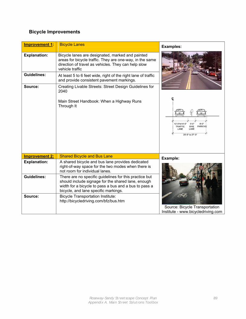
Roseway-Sandy Streetscape Concept Plan Appendix A. Main Street Solutions Toolbox
89
Bicycle Improvements
Improvement 1: Bicycle Lanes
Explanation: Bicycle lanes are designated, marked and painted areas for bicycle traffic. They are one-way, in the same direction of travel as vehicles. They can help slow vehicle traffic
Guidelines: At least 5 to 6 feet wide, right of the right lane of traffic and provide consistent pavement markings.
Source: Creating Livable Streets: Street Design Guidelines for 2040 Main Street Handbook: When a Highway Runs Through It
Examples:
Improvement 2: Shared Bicycle and Bus Lane Explanation: A shared bicycle and bus lane provides dedicated
right-of-way space for the two modes when there is not room for individual lanes.
Guidelines: There are no specific guidelines for this practice but should include signage for the shared lane, enough width for a bicycle to pass a bus and a bus to pass a bicycle, and lane specific markings.
Source: Bicycle Transportation Institute: http://bicycledriving.com/bfz/bus.htm
Example:
Source: Bicycle Transportation Institute - www.bicycledriving.com

Roseway-Sandy Streetscape Concept Plan Appendix A. Main Street Solutions Toolbox
90
Improvement 3: Bicycle Racks
Explanation: Bicycle racks are for bicycle parking and their placement
occurs where there is room on the sidewalk. There are different types, the most common are “staple” style racks but businesses and neighborhood groups can commission unique racks symbolizing an area or district. Bicycle racks help encourage bicycle use in an area.
Guidelines: Bicycle Racks must be within 50 feet of a business’ main entrance. Allow a 2 to 6 foot area for each space.
Source: City of Portland, Office of Transportation. http://www.trans.ci.portland.or.us/bicycles/parkguide.htm Foster Road Plan
Example:
Improvement 4: Bicycle Box
Explanation: A bicycle box enables bicyclists to get to the front of traffic at signalized intersections so that they may better clear the intersection and make left turns than they might otherwise be able. Bicyclists use the bike box when the signal is red.
Guidelines: There are no guidelines for this practice because it is uncommon in the United States but it should be four to five meters deep and a different surface color than other street markings.
Source: Metropolitan Transportation Commission Pedestrian and Bicycle Safety Toolbox http://www.bayareatrafficsignals.org/toolbox/Tools/BikeBox.html Bicyclinginfo.org: Pedestrian and Bicycle Information Center http://www.bicyclinginfo.org/de/signs_markings.htm#new
Example:

Roseway-Sandy Streetscape Concept Plan Appendix A. Main Street Solutions Toolbox
91
Improvement 5: Well-Signed Alternate Bicycle Route
Explanation: A lower-volume roadway that parallels a high-volume
arterial can provide a pleasant alternative to “through” bicyclists, as well as a higher level of mobility and safety. Does not remove the need to help ensure the safety of those bicyclists who still need to use the arterial (especially if there are commercial or other public destinations along that arterial), it should decrease bicycle traffic on the arterial substantially.
Guidelines: • Parallel lower-volume roadway is within .40 km (.25 miles) of high-volume arterial
If main arterial: • has on-street parking and/or multiple
driveways/turning conflicts • ADT >10,000 • Average vehicle speeds > 48 km/h (30 mi/h) • does not have sufficient right-of-way for bicycle
lanes Source: Minnesota DOT Bicycle, Pedestrian, and Telework
Modal Plan
Example:
Improvement 6: Shared Lane Markings
Explanation: To direct bicyclists to where they should ride in the roadway out of the “door zone”; to alert motorists that bicycles are riding in a shared roadway.
Guidelines: • Vehicle speeds < 48 km/h (30 mi/h) • ADT < 10,000 • On urban roadways with width constraints due
to on-street parking and/or limited right-of-way. • On suburban/rural roadways to indicate • The center of the marking should be 11’0 ft from
the curb where parking is allowed, marking placement can be increased for: • Downhill sections (greater then 5%) • Areas where wider vehicles park • Where cyclists at 11’ still may encourage
motorists to pass without changing lanes • The center of the marking should be 4’ from
curb face to centerline where parking is not allowed, but could be shifted according to: • Lane widths, to position cyclist to either
completely take lane or allow for side by side sharing of lane
Obstacles along curb such as seams, depressed grates, etc
Source: Report: San Francisco’s Shared Lane Pavement Markings: Improving Bicycle Safety
Examples:

Roseway-Sandy Streetscape Concept Plan Appendix A. Main Street Solutions Toolbox
92
Vehicle Travel Improvements
Improvement 1: Plant Street Trees
Explanation: Street trees can make streets look smaller to drivers, making them slow down when entering an area where there are street trees. Depending on the type of trees, they can also provide an identity for a main street district and informs drivers when they enter and exit the area.
Guidelines: Space trees so that when mature, the canopy diameters grow within 10 feet of one another. Typical spacing is 15 to 50 feet apart and ideally planted in 5 by 5 foot grates. This helps protect the roots and sets them back 4 feet from on-street parking where car doors could damage them.
Source: Creating Livable Streets: Street Design Guidelines for 2040 Main Street Handbook: When a Highway Runs Through It
Example:
Improvement 2: Provide on-street parking
Explanation: Not only does on-street parking support local economic activity, it also provides a buffer for pedestrians walking on the sidewalk. This increases pedestrians’ sense of safety and physical safety from street traffic. On-street parking also tends to decrease the speed of traffic because vehicles maneuver in and out of spaces.
Guidelines: There are several ways for situating on-street parking on main-streets, including parallel to the right-of-way and diagonally out from the curb. Parallel on-street parking lanes are 7 to 8 feet wide and are best when there are on-street bicycle facilities. Angled parking increase capacity of spaces up to 40 percent. Curb extensions with on-street parking also provide visibility for pedestrians.
Source: Creating Livable Streets: Street Design Guidelines for 2040 Main Street Handbook: When a Highway Runs Through It Project for Public Spaces: Traffic Calming 101 Viewable at: http://www.pps.org/transportation/info/trans_articles/livememtraffic
Example:
Source: www.pedbikeimages.org/dan burden

Roseway-Sandy Streetscape Concept Plan Appendix A. Main Street Solutions Toolbox
93
Improvement 3: Tree and Amenity Bulb-Out
Explanation: Bulb-outs are small areas that extend the pedestrian
zone into the vehicle right-of-way. Trees and other amenities, such as benches, can be placed here to add to the pedestrian environment. Bulb-outs also delineate the on-street parking spaces and narrow the sight distances causing motorists to slow down.
Guidelines: Bulb-outs must provide a large enough radius and large enough space between them for street cleaners and emergency vehicles to maneuver in and out of the space between.
Source: City of Palo Alto, Neighborhood Traffic Calming Program: http://www.cityofpaloalto.org/transportation/ntcp/index.html
Example:
http://www.co.alameda.ca.us/cda/redevelop/projects/cherryland/con
cept.htm
Improvement 4: Gateways
Explanation: Provide visual cues indicating to motorists that they are entering a main street area with significant pedestrian traffic and generally lower posted speed limits
Guidelines: Gateways help to define a sense of place for users Should not visually impair the driver or her ability to react and respond to other vehicles, bicyclists, and pedestrians. Should not interfere with a pedestrian’s ability to maneuver along the sidewalk.
Source:
Example:
Improvement 5: Swales
Explanation: A swale is a vegetated channel that looks similar to a
ditch but are designed and maintained to transport shallow depths of water runoff slowly over vegetation. Swales can remove solids and metals from stormwater runoff.
Guidelines: The most effective swales are between 200 and 250 feet long with a downward slope between one and six percent. Other than size: hydrology, soil types, plant materials, and maintenance components are all necessary to consider for successful swales.
Source: Green Streets: Innovative Solutions for Stormwater and Stream Crossings
Example:

Roseway-Sandy Streetscape Concept Plan Appendix A. Main Street Solutions Toolbox
94
Improvement 6: Pervious Pavement Parking lane
Explanation: Permeable pavers are a load-bearing surface that can
infiltrate water runoff into the underlying reservoir base and soil. Available pavers are only suitable for areas where there is not high traffic volume, such as in the parking lane.
Guidelines: There are various types of pervious surfaces with a variety of different designs. It is difficult to incorporate them into retrofit construction due to compacted soils but it is possible.
Source: Green Streets: Innovative Solutions for Stormwater and Stream Crossings
Example:
Improvement 7: Traffic Circle
Explanation: Traffic circles are raised islands in the center of intersections that traffic circulates around. They require motorists to slow down when entering an intersection to maneuver around them and yield to other motorists. For main streets they are best on adjacent streets to prevent high speeds exiting the main street and for using adjacent streets as faster bypasses.
Guidelines: Traffic circles are usually circular in shape, placed in the center of intersections, and landscaped. Yield signs and traffic circle signs are placed at the streets entering the intersection.
Source: Institute of Transportation Engineers: http://www.ite.org/traffic/circle.htm
Examples:
Source:
http://www.ite.org/traffic/circle.htm
Source:
http://www.trans.ci.portland.or.us/trafficcalming/devices/volume/CIR
CLEALBUM.HTM

Roseway-Sandy Streetscape Concept Plan Appendix B. Sandy Boulevard Business Survey Tool
95
Appendix B. Sandy Boulevard Business Survey Tool

Roseway-Sandy Streetscape Concept Plan Appendix B. Sandy Boulevard Business Survey Tool
96

Roseway-Sandy Streetscape Concept Plan Appendix B. Sandy Boulevard Business Survey Tool
97
Please circle the response that best describes your answer to the following questions.
1. Do you own or lease this building space? Own Lease
2. How long have you been at this location? Less than 1 year 1-5 years More than 5 years
3. Do you live in the neighborhood? Yes No
4. Do the majority of your customers travel from: Immediate neighborhood
(less than a mile) Surrounding neighborhood
(within a mile or two) Outside neighborhood Don’t know
Please indicate how much you agree or disagree with the following statements about Sandy Boulevard from NE 68th to 80th Streets
Strongly Agree Agree
Neither Agree nor Disagree
Disagree Strongly Disagree
5. The addition of trees, benches, and flower boxes would improve the sidewalk area in front of this business
1 2 3 4 5
6. Safer pedestrian street crossings are needed 1 2 3 4 5
7. More marked pedestrian street crossings are needed 1 2 3 4 5
8. Improvements for bicycle riders are needed 1 2 3 4 5
9. This business relies primarily on on-street parking 1 2 3 4 5
10. Reductions in on-street parking would harm this business
1 2 3 4 5
11. Shared surface parking lots off of Sandy Boulevard for customers would benefit businesses
1 2 3 4 5
12. On-street parking restrictions (like 2-hour limits) need to be revised to increase parking availability
1 2 3 4 5
13. The intersection of NE 72nd and Sandy Boulevard needs to be improved
1 2 3 4 5

Roseway-Sandy Streetscape Concept Plan Appendix B. Sandy Boulevard Business Survey Tool
98
14. There is an adequate number of bus stops 1 2 3 4 5
15. Improvements to bus stops are needed 1 2 3 4 5
16. It is difficult to make left hand turns off Sandy Boulevard
1 2 3 4 5
17. The business community has a strong identity 1 2 3 4 5
18. Banners and signs would help create a more visible business district
1 2 3 4 5
19. Describe how you would like Sandy Boulevard to look 20 years from now? 20. What area in Portland would you like to see Sandy Boulevard most resemble? 21. Is there anything else you would like to add?

Roseway-Sandy Streetscape Concept Plan Appendix C. Key Informant Interview Tool
99
Appendix C. Key Informant Interview Tool

Roseway-Sandy Streetscape Concept Plan Appendix C. Key Informant Interview Tool
100

Roseway-Sandy Streetscape Concept Plan Appendix C. Key Informant Interview Tool
101
Background 1. How long have you been living in the Roseway Neighborhood? 2. Do you view your interests in the neighborhood strictly as business owner, resident, both?
Explain? Identity
3. How would characterize the identity of the Roseway neighborhood? If someone asked you to describe your neighborhood – what would say?
4. How do you think Sandy Boulevard is generally perceived by other residents?
Response to Change 5. Do you think some people will welcome change, will others resist it? 6. What elements will people most likely embrace/reject?
Main Streets
7. How would you characterize a Main Street – what does that term mean to you? 8. What are the 3-4 things that have most contributed to the success of other Main Streets in
the Portland area? Sandy Boulevard
9. What are the 3-4 best things about the Sandy Boulevard? 10. How do you view it as part of your neighborhood experience? 11. What benefits, if any, do you get from the goods, services, or experiences provided on Sandy
Boulevard? 12. What are the 3-4 worst things about the Sandy Boulevard? 13. What are the 3-4 main challenges to making the Sandy Boulevard work better at your
neighborhood center? 14. What are some approaches for overcoming these barriers? 15. Given these barriers, how would you redesign Sandy Boulevard and the way people interact
with it? 16. What would be your top three priority areas?
Conclusion
17. Anything else you’d like to tell us that you think we should know?