role of subaerial volcanic rocks and mantle plumes in creation of south atlantic margins
TRANSCRIPT

Role of subaerial volcanic rocks and mantle plumes in creationof South Atlantic margins: implications for salt tectonics and
source rocks
Martin P.A. Jacksona,*, Carlos Cramezb, Jean-Michel Fonckb
aBureau of Economic Geology, The University of Texas at Austin, University Station Box X, Austin, TX 78713-8924, USAbTotalFina Exploration and Production, 24 Cours Michelet, La Defense 10, 92069 Paris La Defense Cedex, France
Received 9 July 1999; received in revised form 10 January 2000; accepted 24 January 2000
Abstract
Seaward-dipping re¯ectors (SDRs) represent ¯ood basalts rapidly extruded during either rifting or initially subaerial sea-¯oor
spreading. Evaporites can form on this basaltic proto-oceanic crust, as in the Afar Triangle today. Evidence for SDRs in SouthAtlantic deep-water regions comes from proximity to the uniquely large Parana ±Etendeka volcanic province onshore, theTristan and Gough hot spots, drilled volcanic rocks, and seismic pro®les showing SDR provinces more than 100 km wide, as
much as 7 km thick, and thousands of kilometers long. SDRs are clearest adjoining the Aptian salt basins. However, wespeculate that SDRs are also present but seismically obscured below the salt basins. We argue that the conjugate Aptian saltbasins are post-breakup, not pre-breakup; they were separated from the start by a mid-oceanic ridge; distal salt accumulated on
proto-oceanic crust, not rift basins. This hypothesis is supported by: seismic stratigraphy and structure; magnetic anomalies;plate reconstructions; and hydrothermal potash evaporites. An important implication for exploration is that thick basalts, ratherthan rift-age source rocks, may underlie distal parts of the salt basins. 7 2000 Elsevier Science Ltd. All rights reserved.
Keywords: Flood basalt; Passive margin; Seaward-dipping re¯ector
1. Background
1.1. Introduction
As exploration of divergent margins advancesthrough deep and ultra-deep water, the nature of thecontinental-oceanic boundary becomes increasingly rel-evant to petroleum systems. For example, it is vital todetermine the structural and stratigraphic context ofsubsalt lacustrine source rocks in basins containingboth clastic rift ®ll and ¯ood basalts.
This paper reviews volcanic rifted margins in gen-eral, then focuses on the role of igneous rocks in conti-nental breakup and margin development in the South
Atlantic. We survey massive suites of subaerial ¯oodbasalts that occur on continental crust, across the con-tinent-ocean transition, and as part of the early-formedoceanic crust. Then we discuss how salt structuresobscure these igneous provinces and speculate on theirfull extent. Finally, we examine the role of salt tec-tonics during continental breakup and argue that theAptian evaporites of the South Atlantic are postriftand thus do not pre-date the onset of sea-¯oor spread-ing.
1.2. Large igneous provinces and mantle plumes
Large Igneous Provinces (LIPs) rapidly create largevolumes of crust, especially in ocean basins and theirdivergent margins. LIPs comprise ma®c rocks that arenot formed by normal sea-¯oor spreading. They occuras onshore continental ¯ood basalts, ¯ood basalts
Marine and Petroleum Geology 17 (2000) 477±498
0264-8172/00/$ - see front matter 7 2000 Elsevier Science Ltd. All rights reserved.
PII: S0264-8172(00 )00006 -4
* Corresponding author. Tel.: +1-512-471-1534; fax: +1-512-471-
0140.

imaged as seaward-dipping re¯ectors, oceanic plateaus,submarine ridges, seamount groups, and ocean-basin¯ood basalts. LIPs also include rocks equivalent tothose listed above in intrusive settings; thicker-than-normal (20±40 km) oceanic crust near continental mar-gins, and lower crustal, underplated bodies havinghigh P-wave velocities below continental margins (Cof-®n & Eldholm, 1994; Eldholm, Skogseid, Planke &Gladczeko, 1995).
The main focus of this paper is on LIPs associatedwith continental breakup in the South Atlantic. LIPsare highly episodic, mostly forming in short-lived(<1±3 Ma) pulses of high-volume magmatism (White,1989). For example, 6 � 106 km3 of magma wereemplaced over an area of >1.3 � 106 km2 in only 3Ma along the rifted margins of the North Atlantic vol-canic province (Co�n & Eldholm, 1994). The LIPs rel-evant to this paper form in volcanic rifted marginswhere crust extends and abundant magmatism is fedby mantle plumes (Burke & Dewey, 1973; Morgan,1983; Co�n & Eldholm, 1994). Although most LIPsare related to mantle plumes, plumes do not seemessential for breakup and the formation of volcanicmargins (Eldholm et al., 1995). Furthermore, someplumes underlie plates without dispersing them (forexample, the giant Ontjong Java and Kerguelenplumes; Co�n & Eldholm, 1994). Spatial relationshipscan be misleading, though. For instance, melts canmove laterally away for vast distances from the plumecenter as lava ¯ows (>750 km for Columbia Riverbasalts; Tolan, Reidel, Beeson, Anderson, Fecht &Swanson, 1989) or dykes (>1500 km for McKenziedyke swarm in Canada; LeCheminant & Heaman,1989).
The comparative roles of extension and mantleplumes in volcanic rifted margins are much debated(White & McKenzie, 1995). Most authors envisagethat melt is generated rapidly by adiabatic decompres-sion of a rising mantle plume. The quantity of meltdepends on the amount of lithospheric extension,subtle temperature increases (50±1008C) in the asthe-nosphere, thickness of lithosphere before rifting, andthe duration of rifting (Bown & White, 1994; Eldholmet al., 1995). Most signi®cantly, the subsidence pro-duced by lithospheric extension alone (McKenzie,1978) is o�set along volcanic margins mainly by: (1)addition to the crust of igneous material produced bydecompression and (2) dynamic support by the hot,low-density mantle plume (White & McKenzie, 1989).The impinging plume creates a bulge in the Earth'ssurface 800±2000 km wide and 1±4 km in relief. Thisswell increases gravitational potential, which promoteslateral stretching (rifting) in its crest (White & McKen-zie, 1995). Any unrelated rift system cutting across ahot spot would have enhanced extension and volcan-ism. As the plume head starts to spread and melt litho-
sphere, continental ¯ood volcanism begins suddenlyover an area as much as 2000±2500 km across (White& McKenzie, 1989). Voluminous tholeiitic basaltsescape from the mantle and load the crust. This ¯oodis typical during breakup and initial sea-¯oor spread-ing but can also start before rifting began (as in theAfar plume; Davison et al., 1994).
1.3. Seaward-dipping re¯ectors
The most distinctive LIPs of volcanic rifted marginsare seaward-dipping re¯ectors (SDRs). These were ®rstrecognized on the continental margins of the Norwe-gian Sea (Hinz & Weber, 1976; Mutter, Talwani &Sto�a, 1982; Roberts, Backman, Morton, Murray &Keene, 1984a; Roberts & Schnitker, 1984b) and arenow known to be widespread. Most drilling refractionsurveys on SDRs have been done in the North Atlan-tic.
SDRs represent subaerial basalt ¯ows erupted closeto sea level. SDR sequences are immense. As much as20 km thick, their width varies from tens to hundredsof kilometers; between Greenland and Iceland, theSDR belt is as much as 300 km wide (Hinz, Mutter,Zehnder & NGT Study Group, 1987; Larsen &Jakobsdo ttir, 1988). Their mostly continuous lengthreaches almost 2500 km on the East Greenland margin(Eldholm & Grue, 1994). SDRs form by brief butvoluminous extrusion. For example, along the Green-land rifted margin, subaerial lavas extruded profuselybut brie¯y over 2 million years (Larsen & Jakobsdo t-tir, 1988). In contrast, the Iceland plume has persistedsubaerially for >60 Ma. The major part of SDR pro-vinces lies landward of the oldest identi®able sea-¯oormagnetic anomaly. They generally form a magneticallysubdued band, which results from extrusion within asingle polarity interval or from stacking of ¯oodbasalts.
The North Atlantic SDR provinces have three mainlayers of crust (Eldholm et al., 1995). (1) Upper crustcomprises ¯ood basalts and interbedded sediments. P-wave velocity increases rapidly downward from 3.7 to>5.0 km/s in the upper 1 km then increases moregently below. Velocities reach 6.0±6.5 km/s in the dee-pest SDRs. Signi®cantly, the boundary between ocea-nic Layer 2 and Layer 3 cross-cuts the SDRs. Thus,rather than being a primary igneous feature, thisboundary may represent a metamorphic facies changethat shifts up and down as heat ¯ow and other vari-ables ¯uctuate. (2) Middle crust, which could consistof dykes overlying gabbro, has a velocity of 6.5±6.7km/s at the top. (3) A lower crustal body has high(>7 km/s) velocity and very gentle velocity gradient.These rocks could be MgO-rich intrusions created bybreakup magmatism or could comprise stretched conti-nental crust at granulite facies.
M.P.A Jackson et al. / Marine and Petroleum Geology 17 (2000) 477±498478

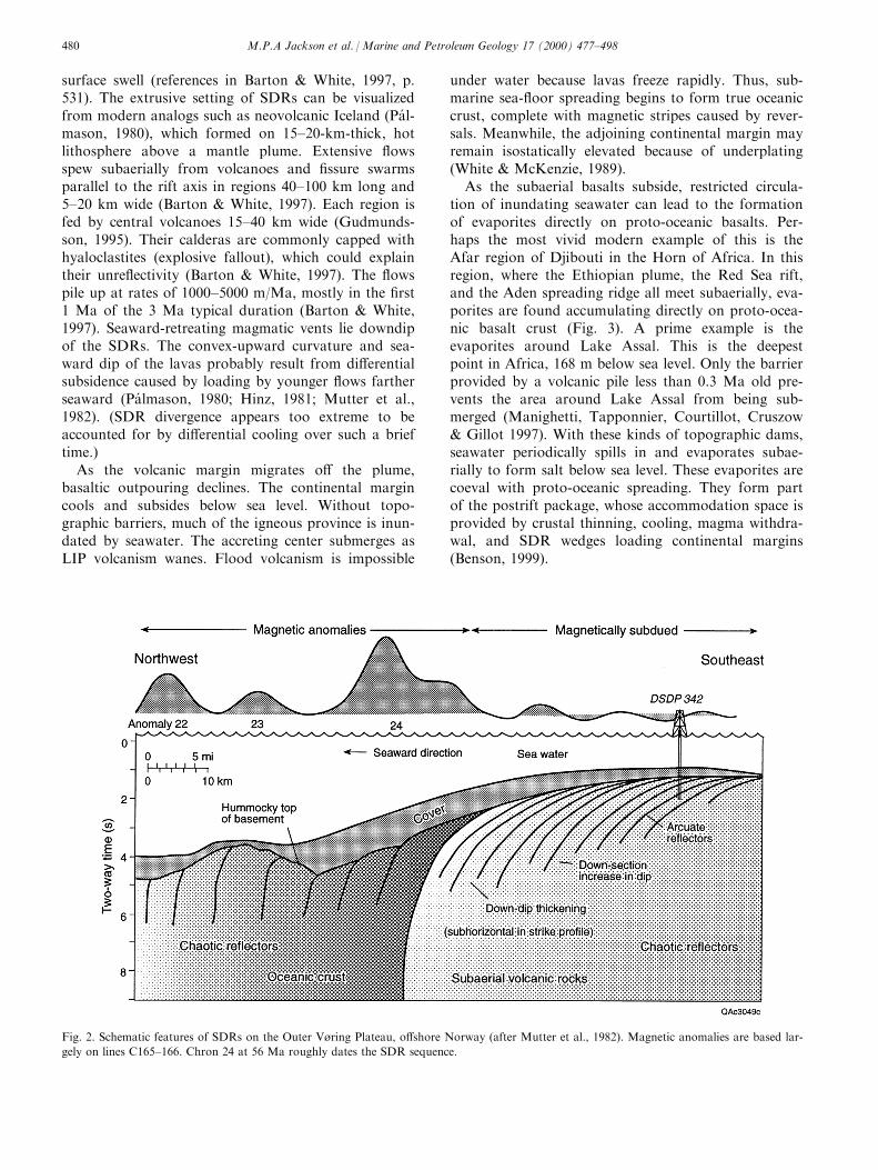
The seismic character of SDRs varies greatly. Vari-ations in continuity, dip, amplitude, re¯ection pat-tern, and thickness are controlled by: (1) volume andrate of magmatic production, (2) the volcanic en-vironment (vent geometry, relation to sea level, etc.),(3) any synvolcanic and postvolcanic deformation,and (4) rate and amount of subsidence (Eldholmet al., 1995). Nevertheless, SDRs have several distinc-tive features (Figs. 1 and 2). These seaward-dippingre¯ectors are convex up; dips steepen seaward fromsubhorizontal nearest the surface to 9±308 at theirbase (Roberts et al., 1984a; Roberts & Schnitker,1984b). Individual re¯ectors can be traced for up to11 km downdip. SDR ¯ows average only 6 m thick,which is too thin to create individual re¯ectors (Bar-ton & White, 1997). SDRs may represent a complexinterference pattern between stacks of thin basalt¯ows and some thick individual ¯ows (Eldholm etal., 1995). Interbedded volcaniclastic sediments andtu�s and weathered ¯ow contacts provide furtherimpedance contrasts (Roberts et al., 1984a; Roberts& Schnitker, 1984b). On strike-parallel pro®les, re¯ec-tors are typically subhorizontal (Barton & White,1997), except where complicated by volcanoes oroblique ®ssures.
Sedimentary re¯ectors conformably overlie the SDRbasement. SDRs disappear downward into noisyre¯ections, where the geology is obscure. SDRs partly
overlie stretched continental crust (Skogseid & Eld-holm, 1995), but deep, rotated fault blocks are rarelyimaged because masses of melt weaken and remobilizethe crust. Landward, SDRs onlap continental crust, in-dicating that their source was seaward. O� Norwayand Rockall, SDRs overlie undisputed oceanic crustand pass laterally and diachronously into normal ocea-nic crust (D.G. Roberts, personal communication1999). Some continental margins, such as the Rockallmargin o� Norway, have double belts of SDRs, bothof which wedge out landward into thin, ¯at-lyingsequences (Barton & White, 1997). The landward SDRpile was emplaced above what is interpreted to bestretched and intruded continental crust, probablybefore breakup. The oceanward SDR belt separatesstretched continental crust and true oceanic crust andwas probably emplaced when subaerial sea-¯oorspreading began. Oceanic crust is typically about 7 kmthick (White & McKenzie, 1995) and has a hummockysurface, including steep-sided volcanic mounds (Eld-holm & Grue, 1994). Oceanic crust is opaque, contain-ing only short or chaotic re¯ectors obscured bydi�ractions.
SDRs are subaerial ¯ood basalts of oceanic compo-sition; the term ``proto-oceanic crust'' (Meyers, Rosen-dal & Austin, 1996a) is thus appropriate. Interbeddedsediments and weathered ¯ow tops indicate that theyare extruded above sea level on a thermally induced
Fig. 1. Seismic pro®le of a typical wedge of seaward-dipping re¯ectors (SDRs) in the basement; this oblique dip line is from the Outer Vùring
Plateau on the continental margin of Norway (after Mutter et al., 1982).
M.P.A Jackson et al. / Marine and Petroleum Geology 17 (2000) 477±498 479
surface swell (references in Barton & White, 1997, p.531). The extrusive setting of SDRs can be visualizedfrom modern analogs such as neovolcanic Iceland (Pa l-mason, 1980), which formed on 15±20-km-thick, hotlithosphere above a mantle plume. Extensive ¯owsspew subaerially from volcanoes and ®ssure swarmsparallel to the rift axis in regions 40±100 km long and5±20 km wide (Barton & White, 1997). Each region isfed by central volcanoes 15±40 km wide (Gudmunds-son, 1995). Their calderas are commonly capped withhyaloclastites (explosive fallout), which could explaintheir unre¯ectivity (Barton & White, 1997). The ¯owspile up at rates of 1000±5000 m/Ma, mostly in the ®rst1 Ma of the 3 Ma typical duration (Barton & White,1997). Seaward-retreating magmatic vents lie downdipof the SDRs. The convex-upward curvature and sea-ward dip of the lavas probably result from di�erentialsubsidence caused by loading by younger ¯ows fartherseaward (Pa lmason, 1980; Hinz, 1981; Mutter et al.,1982). (SDR divergence appears too extreme to beaccounted for by di�erential cooling over such a brieftime.)
As the volcanic margin migrates o� the plume,basaltic outpouring declines. The continental margincools and subsides below sea level. Without topo-graphic barriers, much of the igneous province is inun-dated by seawater. The accreting center submerges asLIP volcanism wanes. Flood volcanism is impossible
under water because lavas freeze rapidly. Thus, sub-marine sea-¯oor spreading begins to form true oceaniccrust, complete with magnetic stripes caused by rever-sals. Meanwhile, the adjoining continental margin mayremain isostatically elevated because of underplating(White & McKenzie, 1989).
As the subaerial basalts subside, restricted circula-tion of inundating seawater can lead to the formationof evaporites directly on proto-oceanic basalts. Per-haps the most vivid modern example of this is theAfar region of Djibouti in the Horn of Africa. In thisregion, where the Ethiopian plume, the Red Sea rift,and the Aden spreading ridge all meet subaerially, eva-porites are found accumulating directly on proto-ocea-nic basalt crust (Fig. 3). A prime example is theevaporites around Lake Assal. This is the deepestpoint in Africa, 168 m below sea level. Only the barrierprovided by a volcanic pile less than 0.3 Ma old pre-vents the area around Lake Assal from being sub-merged (Manighetti, Tapponnier, Courtillot, Cruszow& Gillot 1997). With these kinds of topographic dams,seawater periodically spills in and evaporates subae-rially to form salt below sea level. These evaporites arecoeval with proto-oceanic spreading. They form partof the postrift package, whose accommodation space isprovided by crustal thinning, cooling, magma withdra-wal, and SDR wedges loading continental margins(Benson, 1999).
Fig. 2. Schematic features of SDRs on the Outer Vùring Plateau, o�shore Norway (after Mutter et al., 1982). Magnetic anomalies are based lar-
gely on lines C165±166. Chron 24 at 56 Ma roughly dates the SDR sequence.
M.P.A Jackson et al. / Marine and Petroleum Geology 17 (2000) 477±498480

2. South Atlantic breakup
2.1. Rifting history
As Pangea dispersed, the Atlantic Ocean opened inthree main phases: ®rst, the southern North Atlantic,then the South Atlantic, then the Equatorial Atlantic.In the South Atlantic, rifting and the onset of sea-¯oorspreading generally became younger northwards, likean opening zipper. This idea is supported by the fol-lowing two paragraphs although data quality variesgreatly.
Least reliable is the onset of rifting, which isrecorded by the oldest rift ®ll. Because of their depth,the oldest strata are rarely drilled o�shore. Thus, esti-mates for the onset of rifting vary widely for any par-ticular basin by as much as 20 Ma. Estimates for theonset of rifting have the following ranges in Africanbasins, listed from south to north: Cape, 220±200 Ma(Light, Maslanyi & Banks, 1992); Orange, 160 Ma(Erlank et al., 1984) to 144 Ma (Guiraud & Maurin,1992); LuÈ deritz±Walvis, 126 Ma (NuÈ rnberg & MuÈ ller,1991); Benguela±Kwanza±Congo±South Gabon, 144Ma (Teisserenc & Villemin, 1989; Guiraud & Maurin,
Fig. 3. The Afar triple junction in Djibouti, Horn of Africa. Evaporites accumulating subaerially below sea level appear as pale patches, outlined
in red, on dark ¯ood basalts representing proto-oceanic crust. The evaporites are especially prominent around the shores of Lake Assal (A) but
also occur in half-grabens. Lake Assal occupies the interior (eastern) end of the Assal rift (B) behind a barrier of lavas <0.3 Ma old (C), which
separate Lake Assal from Ghoubbet (D) and the Gulf of Tadjoura (E) containing the obliquely propagating, left-stepping Aden spreading axis.
Shadowed fault scarps yield mainly left-lateral fault-plane solutions. Space shuttle photograph STS 41G-35-104, courtesy of NASA, was shot in
1984. Geology based on Manighetti et al. (1997). Scale applies to foreground only.
M.P.A Jackson et al. / Marine and Petroleum Geology 17 (2000) 477±498 481

1992) to 140 Ma (Brice, Cochran, Pardo & Edwards,1982); North Gabon, 125±122 Ma (Teisserenc & Ville-min, 1989); Rio Muni±Douala-Benue, 119 Ma (NuÈ rn-berg & MuÈ ller, 1991). Along the conjugate Brazilianmargin, the earliest rifting was non-systematic: the old-est known rift ®ll (145±134 Ma) lies far north in theReconcavo, Espirito Santo and Potiguar Basins, coevalwith conjugate African basins but much later thanAfrican basins farther south (Davison, 1999).
The end of rifting can be established by the age ofthe sag basins immediately above the breakup uncon-formity or by the oldest magnetic anomaly in adjoin-ing oceanic crust. North of the Walvis Ridge and RioGrande Rise (the trails of the Tristan and Gough hotspots), early ocean opening apparently coincided withthe long, normally magnetized period of the Cretac-eous Quiet Zone (119±85 Ma) (MuÈ ller, Royer & Law-ver, 1993) so is poorly constrained by magneticreversals. Estimates for the end of rifting and the onsetof sea-¯oor spreading have the following ranges inAfrican basins, listed from south to north: Cape±Orange±LuÈ deritz, 137 Ma (Austin & Uchupi, 1982;Gladczenko, Hinz, Eldholm, Meyer, Neben & Skog-seid, 1997; Peate, 1997) to 130 Ma (NuÈ rnberg & MuÈ l-ler, 1991); Walvis, 126 Ma (Gladczenko et al., 1997);Benguela±Kwanza±Congo±Gabon, 127 Ma (Brice etal., 1982) to 117 Ma (Teisserenc & Villemin, 1989;Guiraud & Maurin, 1992; Karner & Driscoll, 1998);Rio Muni-Douala, 118 Ma (NuÈ rnberg & MuÈ ller,1991); Benue, 80 Ma (NuÈ rnberg & MuÈ ller, 1991).
These ages provide crude but useful benchmarks to
calibrate the tectonic setting of extension, magmatism,stratigraphy and salt tectonics. Our conception of thestratigraphy and crustal units of a generic SouthAtlantic volcanic margin is schematically shown inFig. 4. Conceptual data were derived from the NorthAtlantic volcanic provinces and from many proprietaryand published re¯ection-seismic lines across the SouthAtlantic margins. Three aspects of this diagram are es-pecially important. First, the SDR sequences fan outseaward from a point above a crustal outer high. Sec-ond, the Aptian salt (or age equivalent) is shown aspinching out seaward, probably over volcanic crust inthe SDR province. The limit of continental crust canbe assigned to the seaward limit of the deepest visiblere¯ector at the base of the SDR pile. However, thecontinental-oceanic boundary is typically a broad zonerather than a mappable line, and it is di�cult to infercrustal type from seismic velocities alone (White &McKenzie, 1989). Third, the base of the Aptian salt orage equivalent was later deformed in one or moresteps, the largest of which is the ¯exure known as theAtlantic Hinge.
2.2. Onshore magmatism
The SDRs form the thickest component of theSouth Atlantic igneous provinces (Figs. 4 and 5),whose entire known volume, including continental¯ood basalts, is at least 2� 106 km3 (Peate, 1997). TheParana ±Etendeka province alone has a preservedvolume of >1 � 106 km3 and an area of >1.2 � 106
Fig. 4. Schematic cross-section of a generic volcanic rifted margin in the South Atlantic. Crustal units and dimensions are based on North Atlan-
tic volcanic margins and on the Namibian margin (Gerrard & Smith, 1982; Gladczenko et al., 1997). Refraction data are sparse, so the P-wave
velocities shown (4.0±8.0 km/s) are speculative. Salt-tectonics e�ects have been omitted for clarity. BUU, breakup unconformity; COB, the conti-
nental-oceanic boundary, varies in position from modern continental rise to shelf. Vertical exaggeration is roughly 4:1.
M.P.A Jackson et al. / Marine and Petroleum Geology 17 (2000) 477±498482

km2 in South America (Cordani & Vandoros, 1967).This is the largest exposed basalt province in the world(White & McKenzie, 1989). The late-synrift Etendekaigneous rocks now preserved onshore are much lessabundant than in the Parana Basin. The Etendeka vol-canic rocks are scattered along more than 1500 km ofthe West African coast from Walvis Bay to Luanda(Peate, 1997). The size and volume of onshore igneousrocks suggest equally massive volumes o�shore.
The large thermal anomaly required for the volcanicrifted margins is linked to the Tristan hot spot (nowactive around Tristan da Cunha) and the Gough hotspot (now active around Gough Island). Active for 120Ma, the plumes apparently left clear hot-spot trailsthat created the Parana ±Etendeka basalts, the SouthAtlantic volcanic rifted margins, the Abutment Pla-teau, the rest of the Walvis Ridge, and the conjugateRio Grande Rise. The Tristan plume provided mostlyconductive heat rather than asthenospheric material tothe Parana ±Etendeka igneous province (Garland,Thompson & Hawkesworth, 1996).
The Parana ±Etendeka igneous province is lopsidedlyconcentrated on the South American Plate, far fromthe breakup zone along the conjugate coastlines. Thisstriking asymmetry has been explained by: (1) a topo-graphic barrier along the African margin (White &McKenzie, 1989); (2) an o�-centre Tristan plume(O'Connor & Duncan, 1990); (3) asymmetric simple
shear during rifting (Peate, 1990); (4) thin lithospherebelow the Parana Basin (Thompson & Gibson, 1991);and (5) a horizontal magmatic pressure gradientbetween the axial rift zone and the Parana Basin(Harry & Sawyer, 1992).
The Parana basin formed as a Late Ordovicianintracratonic basin (Zalan et al., 1990). The main epi-sode of ¯ood basaltic volcanism lasted from 134 to129 Ma, coeval with the end of the rift phase in thesouthern South Atlantic and with the synrift phase ofthe central South Atlantic; the oldest oceanic crust atthis latitude is Chron M4 (127 Ma). Younger magma-tism persisted along the coast from 128 to 120 Ma(Peate, 1997) during sea-¯oor spreading in thesouthern South Atlantic and latest rifting in the centralSouth Atlantic. Timelines cut across Parana compo-sitional units, indicating that di�erent magmas wereerupted coevally in di�erent places over several millionyears (Turner, Regelous, Kelley, Hawkesworth &Mantovani, 1994; Stewart, Turner, Kelley, Hawkes-worth, Kirstein & Mantovani, 1996). However, in gen-eral, compositionally de®ned units dip toward thenorth, which suggests a northward-migrating magmasource (Peate, Hawkesworth & Mantovani, 1992),possibly tracking the northward propagation of rifting(Peate, Hawkesworth, Mantovani & Shukovsky, 1990).
Volcanism was strongly bimodal, dominated byaphyric tholeiitic basalts. Some are reported to have
Fig. 5. Map of Large Igneous Provinces (LIPs) in the south-central Atlantic Ocean (courtesy of M. F. Co�n & L. Gahagan, 1998).
M.P.A Jackson et al. / Marine and Petroleum Geology 17 (2000) 477±498 483

Fig.6.Locationofseismic
lines
(red
stars)onamapofthebathymetry
andtopographyoftheSouth
AtlanticOceananditscontinentalmargins.
M.P.A Jackson et al. / Marine and Petroleum Geology 17 (2000) 477±498484
¯owed more than 340 km (Milner, Duncan, Whitting-ham & Ewart, 1995). Magnetic anisotropy indicatesthat in both provinces, lava ¯ows were controlled bystructures trending parallel to each coastline (Glen,Renne, Milner & Coe, 1997). That is consistent withextrusion along rifting or rifted margins. Rhyoliticeruptions (>1000 km2 ) accompanied the ®nal mag-matic phase along both continental margins (Peate,1997).
Onshore dyke swarms indicate that the lavas orig-inally covered a greater area than preserved today.Dolerite dykes are concentrated in ®ve areas. Fourtrend perpendicular to the coasts: (1) Ponta Grossa,Brazil, (2) Eastern Paraguay, (3) Morro Vermelho,Namibia, and (4) Etendeka, Namibia. This perpendicu-lar trend suggests either failed rifts or inversion (With-jack, Schlische & Olsen, 1999). One swarm trendsparallel to the coast: the Sao Paulo/Rio de Janeiroswarm, emplaced between 133 and 129 Ma, the peakof basalt extrusion. Generally, their 40Ar±39Ar agesand compositions are similar to those of the nearestlava ¯ows. Numerous tholeiitic sills also intrude theParana sediments, attaining an aggregate thickness of1 km (Peate, 1997).
2.3. O�shore SDR provinces
The o�shore SDRs are far less well known than arethe onshore igneous provinces. Although many wells(especially in the Campos Basin) terminate in ¯oodbasalts, the true extent of SDR sequences can only behinted at on seismic pro®les, which suggest that theo�shore SDRs are much thicker (several kilometers)than the average lava thickness (only 0.7 km) in theonshore Parana province (Leinz, Bartorelli & Isotta,1968; Peate et al., 1992). In general, volcanic rocks aremore common along the southern Brazilian marginthan farther north. In the Santos and Campos Basins,the rift ®ll comprises mostly basalts and tu�s, whereasnorth of the latitude of the Parana province, the rift®ll is largely sedimentary (Szatmari, 1998). The best-known SDR provinces are the Barremian SDRs southof the Aptian salt basins (Fig. 5). On the Brazilianmargin, the SDR province is about 3000 km long and60±120 km wide, from north of the Malvinas Plateau(Lohmann, Ho�mann-Rolhe & Hinz, 1995) to theSantos Basin and possibly the Campos Basin. On theAfrican margin, the SDR length is almost as great andup to 200 km wide (Hinz, 1981; Gerrard & Smith,1982; Abreu, 1998). Four localities in the southernAtlantic (Fig. 6) illustrate examples of ¯ood basalts.Drilling has con®rmed two examples, but the thicknessand age of the basalts is poorly known. Some basaltsappear to be proto-oceanic crust (SDRs), whereasothers seem to be late-synrift basalts extruded onthinned continental crust.
2.3.1. Pelotas BasinThe Pelotas Basin in southern Brazil and Argentina
is south of the known limit of Aptian halite, althoughthin anhydrite equivalents are present in the Ariri For-mation in the north (Abreu, 1998; Cainelli & Mohriak,1998). Flood basalts are interpreted in two settings(Fig. 7a). About 800 m of seaward-dipping basaltswere intersected at the bottom of the projected P-3well (Fig. 7b). They were dated at 12428 Ma, indicat-ing a late-synrift age (Mizusaki et al., 1992). The sea-ward tilt of the re¯ectors is attributed to rotation oflate-synrift fault blocks along landward-dipping nor-mal faults (Abreu, 1998; Cainelli & Mohriak, 1998).Under the continental rise, another belt of SDRs is atleast 5 km thick (Fig. 7b and c); the belt is about 450km long and 50±250 km wide along its length (Abreu,1998). These SDRs are undrilled, but their locationnear the continental±oceanic boundary and theirresemblance to drilled SDRs o� the conjugate WalvisBasin suggest that they represent proto-oceanic, sub-aerial ¯ood basalts. Similar interpretations have beenmade by Condi, Abreu, Bally and Sawyer (1996) andCainelli and Mohriak (1998). These inferred ¯oodbasalts are overlain by Aptian-Turonian carbonatesand intercalated shale, representing a shallow carbon-ate platform built during the drift phase (Abreu,1998).
In both the Pelotas Basin and the conjugate WalvisBasin, SDR volcanism appears to have reduced subsi-dence of the margin, as would be expected with heat-ing. In these basins, postvolcanic basement subsidenceappears to be less in the north, where SDRs are wide,than in the south, where SDRs are narrow (Abreu,1998). This is indicated by an inverse relationshipbetween sediment thickness and width of SDR belt. Inboth basins, too, the SDRs dip northwards as well asseawards, perhaps recording a northward migration ofthe spreading centre as Pangea unzipped northward(Abreu, 1998).
To the south, o� the Argentine continental margin,is a continuous SDR province 1500 km long, 50±100km wide, and more than 5 km thick (Hinz, 1990).
The northern boundary of the Pelotas Basin ishighly volcanic and aligned with the Rio Grande(Floriano polis) Fracture Zone, along which magmaleaked to form the Sao Paulo Ridge. The volcanicrocks extend for 0500 km north of the Tristan plumetrail into the Santos and Campos basins, where ¯oodbasalts (134±122 Ma), as much as 600 m thick, havebeen drilled below the Aptian salt. Their geochemistryand age are similar to the late-synrift Parana volcanicrocks (Mizusaki et al., 1992). Just inboard of the sea-ward limit of Aptian salt in the Campos Basin, anSDR province has been interpreted by Cainelli andMohriak (1998). Velocity e�ects associated with over-lying salt bodies severely distort subsalt events, so it is
M.P.A Jackson et al. / Marine and Petroleum Geology 17 (2000) 477±498 485

unknown how far landward this SDR provinceextends.
2.3.2. Jacuipe BasinThe northern limit of known Aptian salt is in the
Muribeca Formation on the Sergipe Basin shelf (Cai-nelli & Mohriak, 1998). In the Jacuipe Basin, whichlies to the south, the salt appears to be thin or absent,
indicating discontinuous salt. No signs of salt tectonicsare visible in Fig. 8. Mohriak, Bassetto and Vieira,(1998) interpreted the Jacuipe facies immediately eastof the distal rift basin (Fig. 8) as evaporites or slumpedsediments. Immediately below the thin Cretaceousinterval, well-de®ned seaward-dipping re¯ectors atleast 6 km thick are visible almost down to theinferred Moho re¯ectors (Fig. 8b). This sequence is
Fig. 7. (a) Seismic pro®le SS-2, referred to here as line 1 in the Pelotas Basin o� southern Brazil. (b, c) Seismic details of SDRs from the areas
outlined in white in pro®le (a). (d) Projected P-3 well data, showing subaerial volcanic rocks. This region is south of the Aptian salt basins. Data
from Fontana (1996) and Cainelli and Mohriak (1998).
M.P.A Jackson et al. / Marine and Petroleum Geology 17 (2000) 477±498486

undrilled, but its geometry and position are typical ofSDRs. We interpret it as proto-oceanic crust emplacedduring or after continental breakup. Farther landward,the same interval thins abruptly into a thin, horizon-tally layered sequence that may represent slightly oldervolcanic rocks extruded on continental crust.
Mohriak, Robelo, Matos and Barros (1995) andMohriak et al. (1998) also interpreted thick wedges ofSDRs basinward in the Jacuipe and Sergipe Basins.Their gravity model included stretched continentalcrust only 5±6 km thick. That seems mechanicallyimplausible because the stretching value (b 07) ismuch more than the theoretical stretching limit of 4.5for continental crust before complete separation(Dewey, 1982).
2.3.3. Walvis BasinThe Walvis Basin o� northern Namibia contains an
SDR province 0100 km wide and as much as 07 kmthick. One of the ®rst SDR provinces reported (Hinz,1981), this is part of a highly volcanic region betweenthe Early Cretaceous (134±129 Ma, latest synrift) Eten-
deka ¯ood basalts onshore and the Late Cretaceous(110±80 Ma, post-breakup) Walvis Ridge o�shore(Tristan hot-spot trail). The SDRs extend southwardto the Cape Basin (Austin & Uchupi, 1982; Gerrard &Smith, 1982). Gladczenko et al. (1997) interpreted fourcrustal units: (1) oceanic crust of normal thickness; (2)thickened oceanic crust, up to 15 km thick (Abreu,Condi, Bally, Sawyer & Droxler, 1996), comprisingmost of the SDR sequence and overlying the breakupunconformity; (3) a 0150-km wide Late Jurassic/EarlyCretaceous rift zone partly covered seaward by a fringeof SDRs and landward by lavas and intrusions; and(4) thicker continental crust to landward, partlystretched by Paleozoic extension. As in the conjugatePelotas Basin, the southern part of the Walvis Basincontains SDR sequences extended in the Cretaceous bylandward-dipping normal faults, which become lesscommon northwards (Abreu, 1998).
The projected well shown in Fig. 9c intersectedroughly 500 m of basalt before drilling stopped. Theseismic pro®le (Fig. 9a) suggests that the SDR pro-vince may comprise two zones. In the east, wedges of
Fig. 8. Seismic pro®le of line 2 in the Jacuipe Basin o� northeastern Brazil. (b) Seismic detail of SDRs from the area outlined in white in pro®le
(a). Data from Mohriak et al. (1998).
M.P.A Jackson et al. / Marine and Petroleum Geology 17 (2000) 477±498 487

lava or sediment expand seaward from the updippinch-out of the 92-Ma maximum ¯ooding surface(the ``medial Hinge Line'' of Maslanyj, Light, Green-wood & Banks, 1992). In the west, downward-steepen-ing re¯ectors expand seaward (Fig. 9c) as proto-oceanic crust that merges seaward with oceanic crust.
2.3.4. Kwanza BasinAlthough no convincing SDRs have been reported
from the Kwanza Basin (Fig. 10a), basalts are cer-tainly present. The well in Fig. 10b intersected nearly 1km of basaltic volcanic rocks below the Cuvo For-mation, a thin continental sag sequence conformablyunderlying the Aptian salt. We do not know how thickthese basalts are or whether they represent proto-ocea-nic crust or synrift volcanic ®ll. Subsalt volcanic rockswere also reported by Dibner, Mitin, Rozhdestvens-
kaya, Seryakov and Ustinova (1986). We speculatethat SDRs are present in o�shore Angola but have notbeen recognized because salt structures have distortedthe continuity of subsalt re¯ectors. SDRs are likely ino�shore Angola because of proximity to mantleplumes at the time of breakup and to the Etendekaigneous province. Any SDRs present would underliethe Aptian salt; all other SDR examples in the SouthAtlantic north and south of the Aptian salt basins pre-date the Aptian interval. Continued volcanism duringevaporite formation, which may be related to thenearby active and subaerial Walvis Ridge, is shown bytu�s intercalated with Aptian evaporites near Luanda(Brognon, 1971).
How much of the West African margin is underlainby SDR sequences is highly speculative. North of theWalvis Basin, the cover is thicker, and magnetic rever-
Fig. 9. Seismic pro®le of line 3 in the Walvis Basin, o�shore Namibia. (b) Seismic detail of SDRs from the area outlined in white in pro®le (a),
(c) Projected well data, showing subaerial volcanic rocks. This region is south of the Aptian salt basins. Data from TotalFina.
M.P.A Jackson et al. / Marine and Petroleum Geology 17 (2000) 477±498488

Fig. 10. (a) Seismic pro®le of line 4 in the Kwanza Basin, o�shore Angola. (b) Similar seismic pro®le of line 5 and well data, showing volcanic
rocks. Data from TotalFina.
M.P.A Jackson et al. / Marine and Petroleum Geology 17 (2000) 477±498 489

sals are lacking in the Cretaceous Quiet Zone. Super-imposed on the residual Bouguer anomaly map ofFig. 11 is the former area of three hot spots duringcontinental breakup, assuming a plume-head diameterof 1200 km. This assumption is conservative: the pre-sent-day bulge in the sea ¯oor around Iceland (Ander-son, McKenzie & Sclater, 1973) and the reconstructedvolcanic provinces just after ocean spreading began(White & McKenzie, 1989) both indicate a bulgeabout 2000 km wide over the Iceland plume. Theselarge dimensions suggest that mantle plumes couldhave in¯uenced almost all the West African margin. Ifso, SDRs could underlie much of the margin in thedeep-water and ultra-deep-water regions. Unpublishedindustry seismic data indicate that SDRs are probablypresent o� Equatorial Guinea, Gabon, and the north-ern Congo Basin, just north of the Kwanza Basin.These are areas where the Aptian salt is thin, so saltstructures are smaller and less likely to mask the sub-salt structure and stratigraphy. As seismic re¯ectiondata improve in quality, more and more divergentmargins around the world appear to be volcanic (Cof-®n & Eldholm, 1992, 1994).
3. Discussion
3.1. Aptian salt tectonics
Wherever Aptian evaporites are present, even asthin layers, salt tectonism has played a major role inthe deformation of postrift sediments. Due to salt'se�ectiveness as a detachment zone, structures abovesalt commonly di�er radically from those below. Inturn, the tectono-stratigraphic setting of salt depositionduring or after rifting has equal importance to its rolein deformation of the margin. Generally, little atten-tion has been paid to the role of salt during breakup.In the South Atlantic, because of an uncertain tectonicsetting, some authors have classi®ed the Aptian eva-porites as ``transitional'' between the rift and driftphases; placing the continental-oceanic boundaryalong the seaward edge of the salt re¯ects the sameambiguity. However, this ambiguity seems unnecessarybecause the evidence summarized below appears tomake it clear.
One hypothesis is that the Aptian salt basinsformed before Pangea broke up and sea-¯oor
Fig. 11. Bouguer residual gravity map of the West African margin; uninterpreted on left, interpreted on right. Data reprocessed by TotalFina
from o�shore Sandwell satellite altimetry and onshore African Gravity Project.
M.P.A Jackson et al. / Marine and Petroleum Geology 17 (2000) 477±498490

spreading began (Evans, 1978; Ojeda, 1982; Guar-dado, Gambo & Lucchesi, 1989; Duval, Cramez &Jackson, 1992; Davison, 1999). We refer to thisscenario as ``pre-breakup salt''. Fig. 12a shows thatrifting would have had to occur both before andafter salt deposition. The conjugate Aptian saltbasins are assumed to have once formed a singlegiant salt basin that was later split by continentalbreakup.
An alternative hypothesis is that Aptian salt basinsformed after the continents separated (Fig. 12b). Inthis ``post-breakup salt'' hypothesis, rifting endedbefore salt was deposited. The African and Braziliansalt basins would have been separated from the start.Several papers have favored this hypothesis (NuÈ rnberg& MuÈ ller, 1991; Guiraud & Maurin, 1992; Karner,Driscoll, McGinnis, Brumbaugh & Cameron, 1997;Abreu, 1998; Fonck, Cramez & Jackson, 1998; Martonet al., in press), but none presents a systematic evalu-ation of both hypotheses. The following themes arerelevant for weighing positive and negative evidence
for each hypothesis: tectono-stratigraphy of salt; tec-tono-stratigraphy of SDRs; distal margin of saltbasins; map pattern of salt basins. All these lines ofevidence contradict the pre-breakup hypothesis andstrongly favour a post-breakup origin for the Aptiansalt basins of the South Atlantic margins.
3.1.1. Tectono-stratigraphy of saltThe Aptian salt demonstrably overlies the breakup
unconformity in most of the Aptian salt basins. Thebase of the salt unconformably overlies tilted riftblocks of clastic or volcanic rocks. In places, thebreakup unconformity is at the base of the salt (Davi-son, 1999); elsewhere, the unconformity underlies a sagsequence conformably overlain by salt (for example,Henry & Abreu, 1998). Only in parts of the SergipeBasin does the ®nal stage of rifting a�ect Aptian salt(Cainelli & Mohriak, 1998) because of northwardpropagation of continental breakup. Thus, rifting hadended and sea-¯oor spreading had begun by the timeAptian salt was accumulating (except for a small over-lap of minor rifting in the Sergipe Basin). So if sea-¯oor spreading had begun by the time the Aptian saltstarted to accumulate (except in the extreme north),the African and Brazilian salt basins must have alwaysbeen separated by the mid-oceanic ridge; we speculatebelow that this ridge was partly subaerial but belowsea level.
3.1.2. Tectono-stratigraphy of SDRsWherever SDRs have been identi®ed on both mar-
gins, they invariably predate the stratigraphic equival-ent of the Aptian salt. Thus, whether or not SDRsactually underlie the salt basins (as we predict, but areseismically masked), SDRs formed before the saltaccumulated. Nowhere is the salt or its time equivalentknown to be overlain by proto-oceanic crust, whichwould be a corollary for pre-breakup salt. Any post-breakup basalts would have sunk into distal salt untilthe lavas froze and strengthened (Needham, 1978).
Flood volcanism both accompanies and follows rift-ing. The most distal SDR sequence is likely to post-date continental separation because the SDRs mergewith oceanic crust. Thus, the SDR proto-oceanic crustshould overlie the breakup unconformity (Fig. 12b;Gladczenko et al., 1997). For example, o�shore basal-tic volcanism in the North Atlantic and Ba�n Bayregions was coeval with the onset of sea-¯oor spread-ing (see compilation by White & McKenzie, 1989).Since the SDR sequence commonly forms in only 1±3m.y., the absolute ages of unconformities at the topand bottom of the SDR sequence could be indistin-guishable, depending on the dating method. Thebreakup unconformity has been ascribed to severalcauses. However, along a volcanic rifted margin, oneplausible cause is the erosion caused by thermal uplift
Fig. 12. Schematic evolutionary sections showing hypotheses for (a)
pre-breakup Aptian salt, and (b) post-breakup Aptian salt. BUU,
breakup unconformity. From Fonck et al. (1998).
M.P.A Jackson et al. / Marine and Petroleum Geology 17 (2000) 477±498 491

above the impinging plume before full-scale ¯ood vol-canism. For example, along the margin of Greenland,marine shales are overlain by a basinwide unconfor-mity created by rapid (<5 Ma) prevolcanic uplift.This unconformity is overlain by ¯uvial sandstones de-rived from exhumed basement; these in turn are over-lain by a marine synvolcanic succession in a rapidlysubsiding basin (Dam, Larsen & Sùnderholm, 1998).In the Kudu 9a-1 well in the Orange Basin, drift-phaseeolian sandstones overlie and are intercalated withbasalts of probable Barremian age (Gerrard & Smith,1982).
3.1.3. Distal margin of salt basinsPre-breakup salt would be thickest in the center of
the giant parent salt basin where maximum subsidenceoccurred above the highly extended breakup zone.Thus, after breakup, the oceanward edge of a pre-breakup salt basin would be an abrupt, fault-boundedmargin through the thickest salt. In contrast, post-breakup salt would wedge out distally against a sea-¯oor rising to the mid-oceanic ridge. Thin, autochtho-nous salt pinches out seaward over oceanic or proto-oceanic crust in the Lower Congo Basin (Lehner & deRuiter, 1977), South Gabon Basin (Meyers, Rosendahl& Austin, 1996a) and North Gabon and DoualaBasins (Meyers, Rosendahl, Groschel-Becker, Austin& Rona, 1996b). Elsewhere on the African margin(Lower Congo, Kwanza, and Benguela Basins), theautochthonous salt is tectonically thickened and isallochthonous along its leading edge, the AngolanEscarpment (Emery, Uchupi, Phillips, Bowin & Mas-cle, 1975). This tectonism obscures the original geome-try of the salt.
We infer that post-breakup Aptian salt basins musthave been con®ned distally by a subaerial mid-oceanicridge in the proto Atlantic Ocean. The inference thatthe Brazilian and African salt basins were always sep-arate follows logically from two propositions docu-mented in the previous paragraphs. First, the Aptiansalt is post-breakup (except in the extreme north whereit is a�ected by the ®nal stage of Sergipe rifting). Sec-ond, the stratigraphic equivalent of Aptian salt post-dates the SDRs. Thus, the salt must have startedaccumulating after extrusion of SDRs and the onset ofsea-¯oor spreading and the development of a mid-oceanic ridge. It is implausible that such a ridge couldhave split a giant salt basin. Evaporites accumulate asresidual ponds in the deepest parts of a basin. So it isunlikely that salt could have buried the thermally elev-ated, actively spreading mid-oceanic ridge, especiallywhere seawater was restricted Ð as is necessary forevaporites to form.
Are there modern analogues for subaerial mid-ocea-nic ridges? Almost all present-day mid-oceanic ridgesare submerged, but this is a feature of old, wide
oceans. A ®tter analogy would be the subaerial partsof mid-oceanic ridges currently thermally elevated byan underlying mantle plume, such as the Djibouti Afaron the Aden Ridge (Fig. 3) or Iceland on the Rey-kjanes Ridge. The Afar hot spot bulge allowed synriftMessinian evaporites to form throughout the Red Seawhile open-marine conditions existed farther south inthe Gulf of Aden (Crossley, Watkins, Raven, Cripps,Carnall & Williams, 1992). As in Afar, the Aptian saltbasins were con®ned to the south by the subaerialswell of the proto Walvis Ridge and Rio Grande Rise.These ridges separated open-marine conditions in thesouth from restricted marine conditions in the north.In the northern parts of both the Walvis Basin and theconjugate Pelotas Basin, where volcanism was mostabundant, the initial oceanic crust kept close to sealevel or at a shallow depth until almost the Turonian(91 Ma, some 20 million years after breakup; Abreu,1998; Dingle, 1999). So it is likely that the mostly sub-aerial volcanic ridges acted as a dam. Gaps in theridges would have allowed restricted access of seawaterto the northern proto South Atlantic (Henry & Abreu,1998). That would favor evaporitic conditions evenafter the oceanic crust had thermally subsided belowsea level, as in the Messinian Mediterranean. However,simple evaporative drawdown would not su�ce:assuming an average salt concentration of 3.5%, com-plete evaporation of the world's oceans would yield asalt layer only 60 m thick (Borchert & Muir, 1964).The equivalent salt thickness for a single evaporativedrawdown in the proto South Atlantic would probablybe less than 20 m, given the average water depth ofthe present South Atlantic (04500 m) compared withthe youthful depth typi®ed by the modern Red Sea(01000 m). Because the Aptian salt thickness averagesat least 1000 m, at least 50 cycles of complete ®llingand evaporation would be required in the available 10m.y. Open-marine conditions were only established inthe middle-upper Albian (Dingle, 1999).
3.1.4. Map pattern of salt basinsThe preferred hypothesis that the Aptian salt basins
postdated continental breakup can also be tested byexamining the basin ®t in plate-tectonic reconstruc-tions. We used the plate-kinematic model of NuÈ rnberg& MuÈ ller (1991), which was based on gravity, magneticand onshore geologic data and which achieved a close®t of plates by allowing intraplate strains and displace-ments along known crustal discontinuities. Fig. 13 istheir restoration at 100 Ma (end of Albian). The twomost important features of this map are the locationof magnetic anomalies and the distribution of Aptiansalt. First, the magnetic anomaly M0 (118 Ma) disap-pears northward underneath Aptian salt in the Santosand Kwanza basins on both sides of the AtlanticOcean (NuÈ rnberg & MuÈ ller, 1991). This disappearance
M.P.A Jackson et al. / Marine and Petroleum Geology 17 (2000) 477±498492

suggests that at least part of the Aptian salt wasdeposited on oceanic crust. Second, the distribution ofAptian salt cannot be reconciled with the hypothesisof a single giant salt basin. The salt distribution isstrikingly asymmetric, being much wider in the southand narrower in the north on the Brazilian marginthan the African margin. At chron M0 (118 Ma), thenorthern South Atlantic was just beginning to open,with negligible oceanic crust. Most signi®cantly, Fig. 14shows that both salt basins cannot be ®tted togetherinto a giant precursor, even over stretched continentalcrust. The basins would have to overlap by roughly220 km. This overlap is probably large enough to fea-ture on any reasonable plate reconstruction. This hugeoverlap cannot be attributed to basinward-spreadingof allochthonous salt sheets. Published and proprietaryseismic lines on each margin show that the fringe ofallochthonous salt is generally less than 30 km wide.The overlap can only be explained if the salt basinsaccumulated after breakup and distally overlie Aptianoceanic or proto-oceanic crust (Fig. 13). The centerand proximal parts of the salt basins overlie stretchedcontinental crust.
Circumstantial evidence of the association of Aptianevaporites with basalts is supplied by evaporite geo-chemistry and mineralogy, based on the work ofHardie (1983, 1990, 1996), summarized as follows.
Evaporites can form from either seawater or hydro-thermal brine. The geochemistry of halite is rarelydiagnostic to distinguish between these two brinesources. However, potash evaporites are much morediagnostic of their brine source, even though they arerare, forming only in the ®nal stage of seawater evap-oration after limestone, dolomite, gypsum and halitehave begun to precipitate. Potash evaporites form twogroups. A rarer group rich in MgSO4 forms by evapor-ation of seawater originating from rivers. The sulfateminerals, polyhalite, kainite, and kieserite are diagnos-tic. This group formed in the Vendian, Late Mississip-pian to Permian and Miocene to Quaternary.
The second, more common group is rich in KCl andCaCl2 and poor in MgSO4. This group cannot formby evaporation of seawater from rivers alone. Thechloride minerals, sylvite, carnallite, tachyhydrite, andbischo®te are diagnostic. This group formed in theCambrian through Early Mississippian and Jurassicthrough Paleogene. CaCl2 brines, that concentrate toform KCl minerals, originate from brines enriched inCaCl2 by hydrothermal water-rock interaction. Themost proli®c host is basalt, hydrothermally altered tospilitic greenstone; albitization releases Ca into thebrine, and chloritization absorbs Mg from the brine.As the brine wells up hydrothermally, the abundantCa combines with any SO4 present to precipitate gyp-
Fig. 13. Plate-tectonic reconstruction of a youthful South Atlantic Ocean at 100 Ma (end of Albian). Geographic coordinates are those of today.
Aptian salt basins based on proprietary data. Plate positions and magnetic anomalies based on Karner and Watts (1982) and NuÈ rnberg and
MuÈ ller (1991).
M.P.A Jackson et al. / Marine and Petroleum Geology 17 (2000) 477±498 493

sum at the surface; the brine in lakes remains enrichedin Ca. Limestones would also be a proli®c source ofCa, but these are rare below the Aptian salts of theSouth Atlantic.
The presence of tachyhydrite and similar chloridesdoes not prove the bedrock for the evaporites wasbasalt. However, the vast thickness, high temperaturesand abundant plagioclase in ¯ood basalts mean thatthese were likely to be the most proli®c source of Ca.All the known Aptian potash evaporites in the SouthAtlantic formed from CaCl2 brines enriched by hydro-thermal alteration. The Sergipe±Alagoas Basin con-tains carnallite±sylvite±tachyhydrite tens of metersthick (Wardlaw, 1972). Aptian evaporites in Gaboncontain carnallite±bischo®te (Teisserenc & Villemin,1989). The Lower Congo Basin contains carnallite±syl-vite with bischo®te±tachyhydrite 150 m thick (Bel-monte, Hirtz & Wenger, 1965). Moreover, Pb-Zn-Cumineralization was widespread during the Early toMid Cretaceous along the South Atlantic margins.CaCl2-rich brine is typically enriched in base metalsbecause it contains roughly 8 times more chloride thanseawater.
Clearly, the Aptian potash evaporites record hydro-thermal interaction with a host rock that is probablybasaltic. Such basalts could be the voluminous, rapidlyemplaced SDR ¯ood basalts. Spilitized basalts also
form steadily at mid-ocean ridges. Alternation of KCland MgSO4 types of potash evaporites has been linkedto secular variation in seawater because of variationsin sea-¯oor spreading rates (Hardie, 1996). The Aptianhad twice the modern spreading rate. Times of rapidspreading are marked by rise of sea level and sea-water temperature, changes in marine carbonate chem-istry, and other greenhouse e�ects. In such times,brines generated at mid-ocean ridges dominate thosederived from river water, so hydrothermally derivedKCl evaporites dominate. Thus, we cannot distinguishthe setting (SDRs or mid-oceanic ridges) of the spili-tized basalts that yielded KCl evaporites.
3.2. Implications for source-bed distribution in the SouthAtlantic
The possibly widespread existence of SDR sequencesbelow salt in deep water has major implications forpetroleum systems. Piles of ¯ood basalts formingproto-oceanic crust several kilometers thick might bepresent where rift ®ll containing potential lacustrinesource rocks was previously interpreted. The seismicresemblance of SDR sequences to rift ®ll is enhancedby the presence of normal faults where rifting a�ectedthe SDR sequence, such as in the Walvis and Pelotasbasins and in Iceland (Larsen & Jakobsdo ttir, 1988).
Fig. 14. Plate-tectonic reconstruction during the birth of the South Atlantic Ocean at 118 Ma (mid-Aptian). The unrealistic 220-km overlap of
the Aptian salt basins suggests that the salt accumulated on oceanic crust younger than 118 Ma. Geographic coordinates are those of today.
Plate positions based on Karner and Watts (1982) and NuÈ rnberg and MuÈ ller (1991).
M.P.A Jackson et al. / Marine and Petroleum Geology 17 (2000) 477±498494

However, subsalt source rocks could occur abovethe SDR sequence. Standing lakes could developabove the SDR sequence, as in Afar (Fig. 3). Some ofthe deeper-water ®elds of the Campos Basin could besourced by such beds in the Lagoa Feia Formationbelow the salt and oceanward of the main crustalhinge line.
Another favourable possibility is for Late Cretac-eous source rocks above the salt. The topographic bar-riers provided by the initially subaerial Walvis Ridgeand Rio Grande Ridge might also restrict circulationand provide anoxic conditions for distal marine shales.
4. Conclusions
Our paper attempts to reconnoiter the continental-oceanic boundary in the deep water of the SouthAtlantic Ocean, which is opening up in major explora-tion programs o� West Africa and Brazil±Argentina.These regions are poorly known because of their inac-cessibility and because salt structures mask subsaltseismic re¯ections, and seismic refraction data aremeager. Thus, available evidence is sparse, widely scat-tered, and equivocal. Nevertheless, we hope that thefollowing clues provide a guide and an incentive toimprove our understanding of frontier explorationregions.
1. SDRs are just as common on volcanic rifted mar-gins of the South Atlantic as they are in the NorthAtlantic. Evidence comes from: (1) the vast volumesof igneous rocks associated with the nearby onshoreParana ±Etendeka volcanic provinces, (2) the Tri-stan, Gough, and St. Helena hot spot trails, (3) seis-mic pro®les showing SDR sequences as much as200 km wide and 7 km thick, and (4) well intersec-tions with basalts in a variety of synrift and postriftsettings.
2. The clearest examples of SDRs in the South Atlan-tic Ocean are north and south of the main Aptiansalt basins. However, we contend that SDRs arealso present below the salt basins but have beenseismically obscured by overlying salt-related struc-tures. Supporting evidence includes: (1) the formerexistence of the Tristan, Gough, and St. Helenamantle plumes below these margins, (2) subsaltbasalts of mixed origin intersected by wells, (3) clearimages of SDRs on the northern and southern mar-gins of the salt basins, and (4) SDRs of mixedclarity imaged below thin salt in deep and ultra-deep water.
3. The conjugate Aptian salt basins formed after notbefore continental separation. The salt basins werealways separate and did not originally form a singlegiant salt basin. The separate salt basins accumu-
lated distally on proto-oceanic crust, not rift basins.A post-breakup origin for the salt is supported bythe stratigraphy and structure recorded on seismiclines: wherever observed, both SDRs and thebreakup unconformity invariably underlie theAptian salt or its stratigraphic equivalent except inthe Sergipe Basin. A post-breakup origin is alsosupported by the distal pinchout of the salt basinson what appears to be typical oceanic crust, by thesalt's relationship with magnetic anomalies and byplate reconstructions showing that the Aptian saltbasins only ®t together if they partly overlie oceaniccrust. Otherwise, the salt basins are forced to over-lap unrealistically by 220 km; this overlap cannot beaccounted for by allochthonous salt tectonics. Cir-cumstantial evidence is also provided by the geo-chemistry of MgSO4-poor potash evaporites, whichare derived by hydrothermal alteration of a hostrock likely to be spilitized basalt.
4. The Aptian salt basins were associated with subaer-ial basalts and continental and shallow-water sedi-ments. Evaporites accumulated in a basin that mayhave been below sea level but protected by theproto Walvis Ridge and Rio Grande Rise. Throughgaps in this mostly subaerial ridge, seawater of thesouthern South Atlantic spilled northward repeat-edly to supply the Aptian evaporites. The separate,conjugate evaporite basins were bounded distally bycrust rising to the mid-oceanic ridge. Evaporitesponded on either side of the spreading center, whichwas probably at least partly subaerial in the protoSouth Atlantic.
5. An important implication for ultradeep-waterexploration is that below the distal parts of the saltbasins, thick piles of basalt may be present ratherthan subsalt rift ®ll containing lacustrine sourcerocks. If so, subsalt source rocks should be searchedfor either proximally in rift sequences or distally inlacustrine sag sequences like the Grey Cuvo For-mation (Kwanza Basin) or the upper Lagoa FeiaFormation (Campos Basin), which stratigraphicallyseparate SDRs and overlying salt.
Acknowledgements
Conversations with Jamie Austin, Bert Bally, KevinBurke, Mike Co�n, Lisa Gahagan, Yves Grosjean,Larry Lawver, Gyorgy Marton, Tony Tankard, andGabor Tari provided useful insights into unfamiliarterritory. Voluminous referee comments by DavidRoberts and Ian Davison substantially improved thispaper. Pat Dickerson of NASA provided space shuttlephotographs. Mike Co�n and Lisa Gahagan supplieda copy of the LIP map produced by the PLATES Pro-
M.P.A Jackson et al. / Marine and Petroleum Geology 17 (2000) 477±498 495

ject at the Institute for Geophysics, The University ofTexas at Austin. This project was supported by Total-Fina, which supplied the proprietary exploration data.Diagrams were drawn by Jennifer Hughes, Pat Alfano,and Joel Lardon, directed by Joel Lardon, and by theauthors. The project was funded by TotalFina S.A.and by the members of the Applied Geodynamics Lab-oratory consortium, which comprised the following oilcompanies: Amerada Hess Corporation; Amoco Pro-duction Company; Anadarko Petroleum Corporation;BHP Petroleum (Americas) Inc.; BP Exploration Inc.;Chevron Production Technology Company; ConocoInc.; Elf Aquitaine; ENI-Agip S.p.A.; Exxon Pro-duction Research Company; Marathon Oil Company;Mobil Exploration and Producing Company; NorskHydro; PanCanadian Petroleum Ltd.; Petroleo Brasi-leiro, S.A.; Phillips Petroleum Company; Saga Pet-roleum ASA; Shell Oil Company; Statoil; Texaco Inc.;TotalFina; Unocal/Spirit; and Vastar Resources Inc.This paper is published with permission of the Direc-tor, Bureau of Economic Geology, The University ofTexas at Austin.
References
Abreu, V. S. (1998). Geologic evolution of conjugate volcanic passive
margins: Walvis (Africa) and Pelotas (South America) Basins.
Ph.D. dissertation, Rice University, Houston, Texas.
Abreu, V. S., Condi, F. J., Bally, A. W., Sawyer, D. S., & Droxler,
A. W. (1996). Tectono-stratigraphic evolution of a volcanic rifted
margin Ð o�shore Namibia. EOS Trans. Amer. Geophys. Union,
November 12, 825.
Anderson, R. N., McKenzie, D. P., & Sclater, J. G. (1973). Gravity,
bathymetry, and convection in the Earth. Earth Planet. Sci. Lett.,
18, 391±407.
Austin, J. A. , Jr., & Uchupi, E. (1982). Continental-oceanic crustal
transition o� Southwest Africa. Am. Assoc. Petrol. Geol. Bull.,
66, 1328±1347.
Barton, A. J., & White, R. S. (1997). Volcanism on the Rockall con-
tinental margin. J. Geol. Soc. London, 154, 531±536.
Belmonte, Y., Hirtz, P., & Wenger, R. (1965). The salt basins of
Gabon and the Congo (Brazzaville), a tentative paleographic in-
terpretation. In Salt basins around Africa (pp. 55±78).
Amsterdam: Elsevier.
Benson, R. N. (1999). Chronology of continental ¯ood basalts and
seaward-dipping re¯ectors of the North American Atlantic conti-
nental margin. EOS Trans. Amer. Geophys. Union., S318.
Borchert, H., & Muir, R. O. (1964). Salt deposits: the origin, meta-
morphism and deformation of evaporites (p. 338). London: Van
Nostrand.
Bown, J. W., & White, R. S. (1994). Variation with spreading rate of
oceanic crustal thickness and geochemistry. Earth Plan. Sci. Lett.,
121, 435±449.
Brice, S. E., Cochran M. D., Pardo, G. Edwards, A. D. (1982).
Tectonics and sedimentation of the south Atlantic rift sequence:
Cabinda, Angola. In: Watkins, J. S., Drake, C. L., (Eds.) Studies
in Continental Margin Geology: Am. Assoc. Petrol. Geol. Memoir,
34, 5±18.
Brognon, G. (1971). The geology of the Angola coast and continen-
tal margin.The geology of the east Atlantic continental margin, 4.
Africa Rept. Natural Environment Res. Council, Inst. Geol. Sci.,
70, 143±152.
Burke, K., & Dewey, J. F. (1973). Plume-generated triple junctions:
key indicators in applying plate tectonics to old rocks. J.
Geology, 81, 406±433.
Cainelli, C., Mohriak, W. U. (1998). Geology of Atlantic Eastern
Brazilian Basins: Am. Assoc. Petrol. Geol. International
Conference and Exhibition, Rio de Janeiro, Short Course on
Brazilian Geology, Part II.
Co�n, M. F., Eldholm, O. (1992). Volcanism and continental break-
up: a global compilation of large igneous provinces. In: Storey,
B. C., Alabaster, T., Pankhurst, R. J., Magmatism and the Causes
of Continental Break-Up (Geol. Soc. London Spec. Publ). 68, 21±
34.
Co�n, M. F., & Eldholm, O. (1994). Large igneous provinces: crus-
tal structure, dimensions, and external consequences. Reviews
Geophysics, 32, 1±36.
Condi, F. J., Abreu, V. S., Bally, A. W., Sawyer, D. S. Evolution of
a volcanic rifted margin: case study from Pelotas Basin, Brazil.
EOS Trans. Amer. Geophys. Union, Washington, DC, November
12. 825, 1996.
Cordani, U. G., & Vandoros, P. (1967). Basaltic rocks of the ParanaÂ
basin. In J. J. Bigarella, R. D. Becker, & J. D. Pinto, Problems in
Brazilian Gondwana Geology, Int. Symp. Gondwana Stratigr.
Palaeontol, 1st, Curitiba (pp. 207±231).
Crossley, R., Watkins, C., Raven, M., Cripps, D., Carnell, A., &
Williams, D. (1992). The sedimentary evolution of the Red Sea
and Gulf of Aden. J.Petrol. Geol., 15, 157±172.
Dam, G., Larsen, M., & Sùnderholm, M. (1998). Sedimentary re-
sponse to mantle plumes: implications from Paleocene onshore
successions, West and East Greenland. Geology, 26, 207±210.
Davison, I. et al. (1994). Geological evolution of the southeastern
Red Sea Rift margin, Republic of Yemen. Geol. Soc. Amer. Bull.,
106, 1474±1493.
Davison, I. (1999). Tectonics and hydrocarbon distribution along the
Brazilian South Atlantic margin. In: Cameron, N. R., Bate, R.
H., Clure, V. S., The oil and gas habitats of the South Atlantic
(Geol. Soc. London, Spec. Publ.) 153, 133±151.
Dewey, J. F. (1982). Plate tectonics and the evolution of the British
Isles. J. Geol. Soc. London., 139, 371±412.
Dibner, V. D., Mitin, N. Y., Rozhdestvenskaya, I. I., Seryakov, M.
M., & Ustinova, L. A. (1986). Geologic structure and halokinesis
on the continental margin of Angola. International Geology
Review, 28, 444±448.
Dingle, R. V. (1999). Walvis Ridge barrier: its in¯uence on palaeoen-
vironments and source rock generation deduced from ostracod
distributions in the early South Atlantic Ocean. In: Cameron, N.
R., Bate, R. H., Clure, V. S., The oil and gas habitats of the
South Atlantic (Geol. Soc. London, Spec. Publ.), 153, 293±302.
Duval, B., Cramez, C., & Jackson, M. P. A. (1992). Raft tectonics in
the Kwanza Basin, Angola. Mar. Petrol. Geol., 9, 389±404.
Eldholm, O., & Grue, K. (1994). North Atlantic volcanic margins:
dimensions and production rates. J. Geophys. Res. B2, 99, 2955±
2968.
Eldholm, O., Skogseid, J., Planke, S., & Gladczenko, T. P. (1995).
Volcanic margin concepts. In E. Banda, M. Torne , & M.
Talwani, Rifted ocean±continent boundaries (pp. 1±16). Dordrecht:
Kluwer.
Emery, K. O., Uchupi, E., Phillips, J., Bowin, C., & Mascle, J.
(1975). Continental margin o� western Africa: Angola to Sierra
Leone. Am. Assoc. Petrol. Geol. Bull., 59, 2209±2265.
Erlank, A. J., Marsh, J. S., Duncan, A. R., Miller, R. McG.,
Hawkesworth, C. J., Betton, P. J. Rex, D. C. (1984).
Geochemistry and Petrogenesis of the Etendeka Volcanic Rocks
from SWA/Namibia. (Geol. Soc. S. Africa Spec. Publ.), 13, 195±
245.
Evans, R. (1978). Origin and signi®cance of evaporites in basins
M.P.A Jackson et al. / Marine and Petroleum Geology 17 (2000) 477±498496

around Atlantic margin. Am.Assoc. Petrol. Geol. Bull., 62, 223±
234.
Fonck, J.-M., Cramez, C., & Jackson, M. P. A. (1998). Role of sub-
aerial volcanic rocks and major unconformities in the creation of
South Atlantic margins. In Am. Assoc. Petrol. Geol. International
Conference Extended Abstracts Volume, Rio de Janeiro, Brazil,
November (pp. 38±39).
Fontana, R. L. (1996). SDR (Seaward-dipping re¯ectors) e a transi-
c° ao crustal na Bacia de Pelotas. In 39th Brazilian Geological
Congress 5 (pp. 425±430).
Garland, F. E., Thompson, R. N., & Hawkesworth, C. J. (1996).
Shifts in the source of Parana basalts through time. Lithos, 37,
223±243.
Gerrard, I., Smith, G. C. (1982). Post-Paleozoic succession and struc-
ture of the Southwestern African continental margin. In:
Watkins, J.S., Drake, C.L., Studies in Continental Margin
Geology, Am. Assoc. Petrol. Geol. Memoir, 34, 49±62.
Gladczenko, T. P., Hinz, K., Eldholm, O., Meyer, H., Neben, S., &
Skogseid, J. (1997). South Atlantic volcanic margins. J. Geol.
Soc. London., 154, 465±470.
Glen, J. M. G., Renne, P. R., Milner, S. C., & Coe, R. S. (1997).
Magma ¯ow inferred from anisotropy of magnetic susceptibility
in the coastal Parana ±Etendeka igneous province: Evidence for
rifting before ¯ood volcanism. Geology, 25, 1131±1134.
Guardado, L. R., Gamboa, L. A. P., Lucchesi, C. F. (1989).
Petroleum geology of the Campos Basin, a model for a producing
Atlantic-type basin. In: Edwards, J. D. Santogrossi, P. A.,
Divergent/Passive Margin Basins, Am. Assoc. Petrol. Geol.
Memoir, 48, 3±79.
Gudmundsson, A. (1995). Infrastructure and mechanics of volcanic
systems in Iceland. Volcanolog. Geothermal Res. J., 64, 1±22.
Guiraud, R., & Maurin, J. (1992). Early Cretaceous rifts of Western
and Central Africa: An overview. Tectonophysics, 213, 153±168.
Hardie, L. A. (1983). Origin of CaCl2 brines by basalt-seawater in-
teraction: Insights provided by some simple mass balance calcu-
lations. Contrib. Mineral. Petrol., 82, 205±213.
Hardie, L. A. (1990). The roles of rifting and hydrothermal CaCl2brines in the origin of potash evaporites: An hypothesis. Amer. J.
Science, 290, 43±106.
Hardie, L. A. (1996). Secular variation in seawater chemistry: an ex-
planation for the coupled secular variation in the mineralogies of
marine limestones and potash evaporites over the past 600 m.y.
Geology, 24, 279±283.
Harry, D. L., & Sawyer, D. S. (1992). Basaltic volcanism, mantle
plumes, and the mechanics of rifting: the Parana ¯ood basalt pro-
vince of South America. Geology, 20, 207±210.
Henry, S. G., Abreu, V., (1998). Marine transgressions in the pre-
salt of the South Atlantic: new models for rifting and continental
breakup. Am. Assoc. Petrol. Geol. Annual Convention Abstracts
CD.
Hinz, K. (1981). A hypothesis on terrestrial catastrophes: wedges of
very thick oceanward dipping layers beneath passive continental
margins Ð their origin and paleoenvironmental signi®cance.
Geologische Jahrebuch, Reihe E, Geophysik, 22, 3±28.
Hinz, K. (1990). The Argentine eastern continental margin: structure
and geological development. Am. Assoc. Petrol. Geol. Bull., 74,
675±676.
Hinz, K., & Weber, J (1976). Zum geologischen Aufbau des
Norwegischen Kontinentalrandes und der Barents-See nach
re¯exionsseismischen Messungen. Erdol und Kohle, Erdgas
Petrochemie, Compendium, 57/76, 3±29 Leinfelden/Echterdingen.
Hinz, K., Mutter, J. C., Zehnder, C.M. & the NGT Study Group,
(1987). Symmetric conjugation of continent-ocean boundary
structures along the Norwegian and east Greenland margins.
Mar. Petrol. Geol., 4, 166±187.
Karner, G. D., & Driscoll, N. W. (1998). Tectonic setting of the
Marnes-Noires/Falcao source rocks of the Congo and Angolan
continental margins. Am. Assoc. Petrol. Geol. Bull., 82.
Karner, G. D., Driscoll, N. W., McGinnis, J. P., Brumbaugh, W.
D., & Cameron, N. R. (1997). Tectonic signi®cance of syn-rift
sediment packages across the Gabon-Cabinda continental margin.
Mar. Petrol. Geol., 14, 973±1000.
Karner, G. D., & Watts, A. B. (1982). On isostasy at Atlantic-type
continental margins. J. Geophys. Res., 87,B4, 2923±2948.
Larsen, H. C., Jakobsdo ttir, S. (1988). Distribution, crustal proper-
ties and signi®cance of seawards-dipping sub-basement re¯ectors
o� E Greenland. In: Morton, A. C., Parson, L. M., Early
Tertiary Volcanism and the Opening of the NE Atlantic (Geol.
Soc. London Spec. Publ.) 39, 95±114.
LeCheminant, A. N., & Heaman, L. M. (1989). Mackenzie igneous
events, Canada: middle Proterozoic hot spot magmatism associ-
ated with ocean opening. Earth Planet. Sci. Lett., 96, 38±48.
Lehner, P., & de Ruiter, P. A. C. (1977). Structural history of
Atlantic margin of Africa. Am. Assoc. Petrol. Geol. Bull., 61,
961±981.
Leinz, V. Bartorelli, A., & Isotta, C. A. (1968). Contibuic° ao ao
estudo do magmatism basa ltico Mesozo ic da bacia do Parana .
Ann. Acad. Bras. CieÃnc., 40, 167±181.
Light, M. P. R., Maslanyj, M. P., Banks, N. L. (1992). New geophy-
sical evidence for extensional tectonics on the divergent margin
o�shore Namibia. In: Storey, B. C., Alabaster, T. and Pankhurst,
R. J., Magmatism and the causes of continental break-up (Geol.
Soc. London Spec. Publ.) 68, 257±270.
Lohmann, H. H., Ho�mann-Rolhe, J., Hinz, K., (1995). Argentine.
In: Kulke, H. Regional petroleum geology of the world. Part II:
Africa, America, Australia and Antarctica, Berlin, 549±577.
McKenzie, D. P. (1978). Some remarks on the development of sedi-
mentary basins. Earth Planet. Sci. Lett., 40, 25±32.
Manighetti, I., Tapponnier, P., Courtillot, V., Gruszow, S., & Gillot,
P.-Y. (1997). Propagation of rifting along the Arabia-Somalia
plate boundary: The Gulfs of Aden and Tadjoura. J. Geophys.
Res., 102, B2, 2681±2710.
Maslanyj, M. P., Light, M. P. R., Greenwood, R. J., & Banks, N. L.
(1992). Extension tectonics o�shore Namibia and evidence for
passive rifting in the South Atlantic. Mar. Petrol. Geol., 9, 590±
601.
Meyers, J. B., Rosendahl, B. R., & Austin Jr, J. A. (1996a). Deep-
penetrating MCS imaging of the South Gabon Basin:
Implications for rift tectonics and post-breakup salt remobiliza-
tion. Basin Res., 8, 65±84.
Meyers, J. B., Rosendahl, B. R., Groschel-Becker, H., Austin Jr, J.
A., & Rona, P. A. (1996b). Deep penetrating MCS imaging of
the rift-to-drift transition, o�shore Douala and North Gabon
basins, West Africa. Mar. Petrol. Geol., 13, 791±835.
Milner, S. C., Duncan, A. R., Whittingham, A. M., & Ewart, A.
(1995). Trans-Atlantic correlation of eruptive sequences and indi-
vidual silicic units within the Parana ±Etendeka igneous province.
J. Volcanol. Geotherm. Res., 69, 137±157.
Mizusaki, A. M. P., Petrini, R., Bellieni, G., Comin-Chiaramonti, P.,
Dias, J., Min, A., & Piccirillo, E. M. (1992). Basalt magmatism
along the passive continental margin of SE Brazil (Campos
basin). Contrib. Mineral Petrol., 111, 143±160.
Mohriak, W. U., Bassetto, M., & Vieira, I. S. (1998). Crustal archi-
tecture and tectonic evolution of the Sergipe-Alagoas and Jacui pe
basin, o�shore northeastern Brazil. Tectonophysics, 288, 199±220.
Mohriak, W. U., Rabelo, J. H. L., Matos, R. D., & Barros, M. C.
(1995). Deep seismic re¯ection pro®ling of sedimentary basins o�-
shore Brazil: Geological objectives and preliminary results in the
Sergipe Basin. J. Geodynamics, 20, 515±539.
Morgan, W. J. (1983). Hot spot tracks and the early rifting of the
Atlantic. Tectonophysics, 94, 123±139.
MuÈ ller, R. D., Royer, J.-Y., & Lawver, L. A. (1993). Revised plate
M.P.A Jackson et al. / Marine and Petroleum Geology 17 (2000) 477±498 497

motions relative to the hot spots from combined Atlantic and
Indian Ocean hot spot tracks. Geology, 21, 275±278.
Mutter, J. C., Talwani, M., & Sto�a, P. L. (1982). Origin of sea-
ward-dipping re¯ectors in oceanic crust o� the Norwegian margin
by ``subaerial sea-¯oor spreading''. Geology, 10, 353±357.
Needham, R. S. (1978). Giant-scale hydroplastic deformation struc-
tures formed by the loading of basalt onto water-saturated sand,
Middle Proterozoic, Northern Territory, Australia.
Sedimentology, 25, 285±295.
NuÈ rnberg, D., & MuÈ ller, R. D. (1991). The tectonic evolution of the
South Atlantic from Late Jurassic to present. Tectonophysics,
191, 27±53.
O'Connor, J. M., & Duncan, R. A. (1990). Evolution of the Walvis
Ridge Ð Rio Grande Rise hot spot system: Implications for
African and South American plate motions over plumes. J.
Geophys, Res., 95, 17474±17502.
Ojeda, H. A. O. (1982). Structural framework, stratigraphy, and
evolution of Brazilian marginal basins. Am. Assoc. Petrol. Geol.
Bull., 66, 732±749.
Pa lmason, G. (1980). A continuum model of crustal generation in
Iceland; Kinematic aspects. J.Geophysics., 47, 7±18.
Peate, D. W. (1990). Stratigraphy and petrogenesis of the Parana con-
tinental ¯ood basalts, southern Brazil. Ph. D. thesis, The Open
University, Milton Keynes.
Peate, D. W. (1997). The Parana ±Etendeka Province. In: Mahoney,
J. J., Co�n, M. F. Continental, Oceanic, and Planetary Flood
Volcanism, Geophysical Monograph 100, 217±245.
Peate, D. W., Hawkesworth, C. J., & Mantovani, M. S. M. (1992).
Chemical stratigraphy of the Parana lavas (South America):
classi®cation of magma types and their spatial distribution. Bull.
Volcanol., 55, 119±139.
Peate, D. W., Hawkesworth, C. J., Mantovani, M. S. M., &
Shukovsky, W. (1990). Mantle plumes and ¯ood basalt stratigra-
phy in the Parana , South America. Geology, 18, 1223±1226.
Roberts, D. G., Backman, J., Morton, A. C. Murray, J. W., Keene,
J. B. (1984a). Evolution of volcanic rifted margins: Synthesis of
Leg 81 results on the west margin of Rockall Plateau. In:
Blackman J., Init. Rep. DSDP 81, 883±911.
Roberts, D. G., & Schnitker (1984b). Initial reports of the Deep Sea
Drilling Project, 81. Washington: U.S. Government Printing
O�ce.
Skogseid, J., & Eldholm, O. (1995). Rifted continental margin o�
mid-Norway. In E. Banda, M. Torne , & M. Talwani, Rifted
ocean-continent boundaries (pp. 147±152). Dordrecht: Kluwer.
Stewart, K. S., Turner, S., Kelley, S., Hawkesworth, C. J., Kirstein,
L., & Mantovani, M. S. M. (1996). 3-D 40Ar-39Ar geochronology
in the Parana ¯ood basalt province. Earth Planet. Sci. Lett., 143,
95±110.
Szatmari, P. (1998). Tectonic habitat of petroleum along the South
Atlantic margins. In Am. Assoc. Petrol. Geol. International
Conference Extended Abstracts Volume, Rio de Janeiro, Brazil,
November (pp. 362±363).
Teisserenc, P., Villemin J. (1989). Sedimentary basin of Gabon Ð
Geology and oil systems. In: Edwards, J. D., Santogrossi P. A.,
Divergent/passive margin basins, Am. Assoc. Petrol. Geol. Memoir,
48, 117±199.
Thompson, R. N., & Gibson, S. A. (1991). Subcontinental mantle
plumes, hot spots and pre-existing thinspots. J. Geol. Soc.
London., 147, 973±977.
Tolan, T. L., Reidel, S. P., Beeson, M. H., Anderson, J. L., Fecht,
K. R., Swanson, D. A. (1989). Revisions to the estimates of the
areal extent and volume of the Columbia River Basalt Group. In:
Reidel, S. P., Hooper, P. R., Volcanism and tectonism in the
Columbia River Flood Basalt Province (Geol. Soc. Amer. Spec.
Publ.) 239, 1±20.
Turner, S. P., Regelous, M., Kelley, S., Hawkesworth, C. J., &
Mantovani, M. S. M. (1994). Magmatism and continental break-
up in the South Atlantic: high-precision 40Ar-39Ar geochronology.
Earth Plan. Sci. Let., 121, 333±348.
Wardlaw, N. C. (1972). Unusual marine evaporites with salts of cal-
cium and magnesium chloride in Cretaceous basins o� Sergipe,
Brazil. Econ. Geol., 67, 156±168.
White, R. S. (1989). Igneous outbursts and mass extinctions. EOS
Trans. Amer. Geophys. Union, Washington, D.C., 70, 1490±1491.
White, R. S., & McKenzie, D. (1989). Magmatism at rift zones: The
generation of volcanic continental margins and ¯ood basalts.
J.Geophys. Res., 94, B6, 7685±7729.
White, R. S., & McKenzie, D. M. (1995). Mantle plumes and ¯ood
basalts. J. Geophys. Res., 100, B9, 17543±17585.
Withjack, M. O., Schlische, R. W., & Olsen, P. E. (1999). Relative
timing of Eastern North America magmatism, rifting, drifting,
and inversion. EOS Trans. Amer. Geophys. Union, S319.
Zalan, P. V., Wolf, S., Astol®, M. A. M., Vieira, I. S., Conceic° ao, J.C. J., Appi, V. T. T., Neto, E. V. S., Cerqueira, J. R., Marques,
A. (1990). The Parana Basin, Brazil. In: Leighton, M. W.,
Kolata, D. R., D. Oltz, S. and Eidel, J. J. Interior cratonic basins
Am. Assoc. Petrol. Geol. Memoir, 51, 681±701.
M.P.A Jackson et al. / Marine and Petroleum Geology 17 (2000) 477±498498