role of nhd/nhdplus for environmental-flow based ... of nhd/nhdplus for environmental-flow based...
TRANSCRIPT

U.S. Department of the Interior U.S. Geological Survey
Role of NHD/NHDPlus for environmental-flow based legislation in Michigan and environmental-flow framework for the US Great Lakes Basin Howard W. Reeves, USGS Michigan-Ohio Water Science Center Paul W. Seelbach, USGS Great Lakes Science Center James E. McKenna, Jr., USGS Great Lakes Science Center

Overview
Great Lakes-St. Lawrence River Basin Water Resources Compact Interstate Compact Companion International Agreement
Implemented by each state Regional goals for water conservation and efficiency Prevent adverse resource impact from new or
increased water withdrawals
http://www.cglslgp.org/projects/water-management/great-lakes-agreement-and-compact/

Michigan Water Withdrawal Assessment Streamflow data Fish presence and abundance Stream temperature Aquifer distribution and characteristics
Steinman and others, 2011.

Role of NHD and NHDPlus
NHD connectivity and catchment information: Streamflow estimates Stream temperature modeling Fish presence and abundance modeling Streamflow classification Withdrawal accounting for cumulative impact
assessment

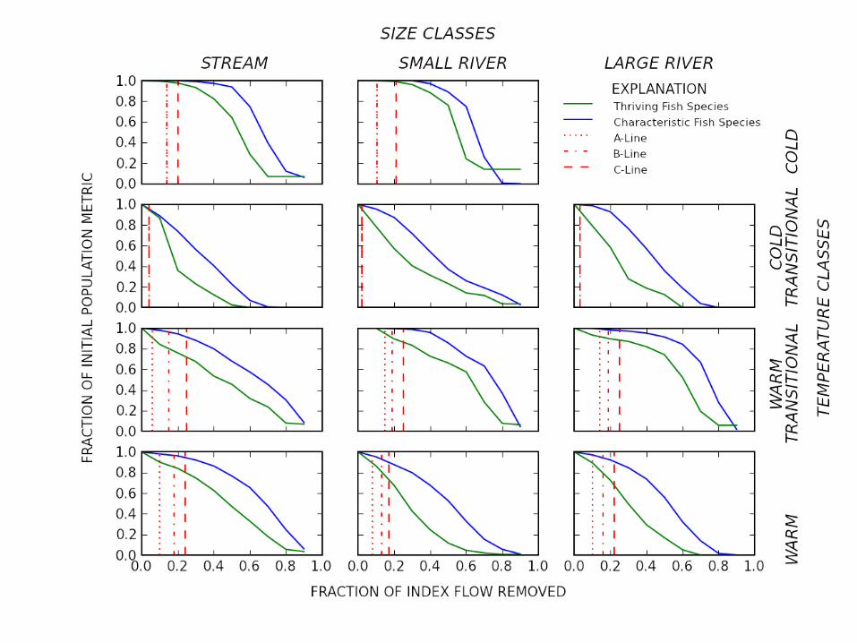
Stream Classification and Ecological Response
Classification based on drainage area, stream temperature, and fish community
Represents diversity in settings across the state
Used to estimate impacts of withdrawal on fish communities
Allows setting of thresholds Thresholds are different for
different settings Set through legislative process
Preserve the geography of flow

Ecological Response Curves
Zorn and others, 2012

Hamilton and Seelbach, 2011
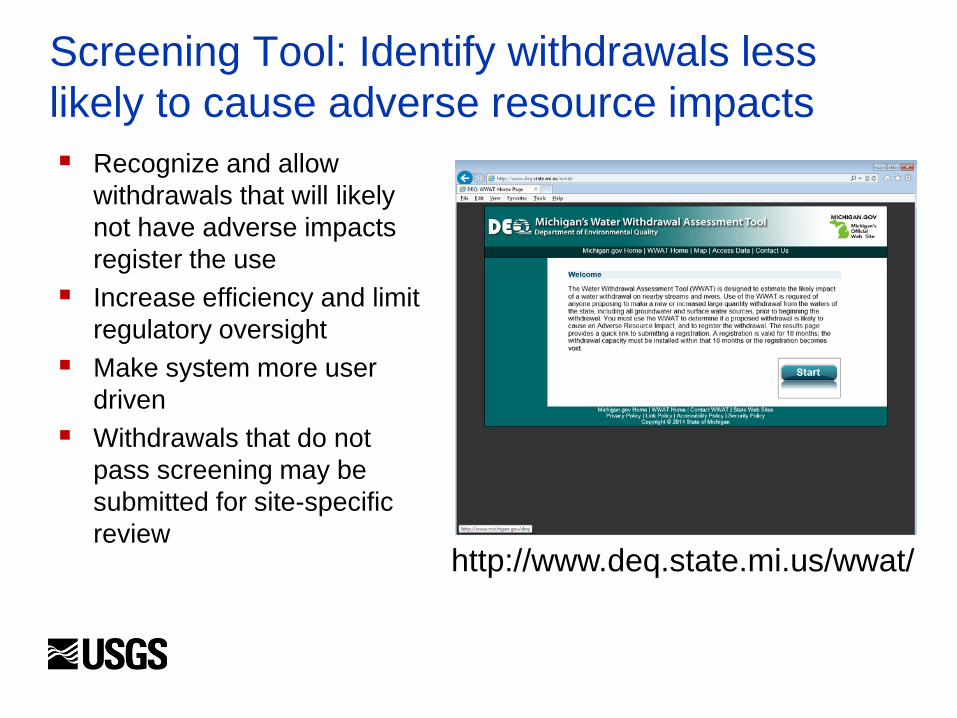
Screening Tool: Identify withdrawals less likely to cause adverse resource impacts Recognize and allow
withdrawals that will likely not have adverse impacts register the use
Increase efficiency and limit regulatory oversight
Make system more user driven
Withdrawals that do not pass screening may be submitted for site-specific review http://www.deq.state.mi.us/wwat/

Great Lakes Basin
Given science components of Michigan implementation of the Compact – can we provide same information regionally? Great Lakes Restoration Initiative

Role of NHD and NHDPlus
Streamflow estimates: need stream network and catchments to get landscape information for ungaged stream estimates (Luukkonen and others, 2014) Stream temperature modeling Fish presence and abundance Streamflow classification

AFINCH
Analysis of Flows in Network of Channels Constrained regression technique Linear regression to estimate yield from catchments Yield * area = incremental flow from catchment Sum incremental flow down the network -> streamflow Estimates are corrected by adjusting incremental
yields upstream of observed flows at streamgages Resulting estimated monthly flows match observed at active
gages used in the regression step

http://cida.usgs.gov/glri/afinch/

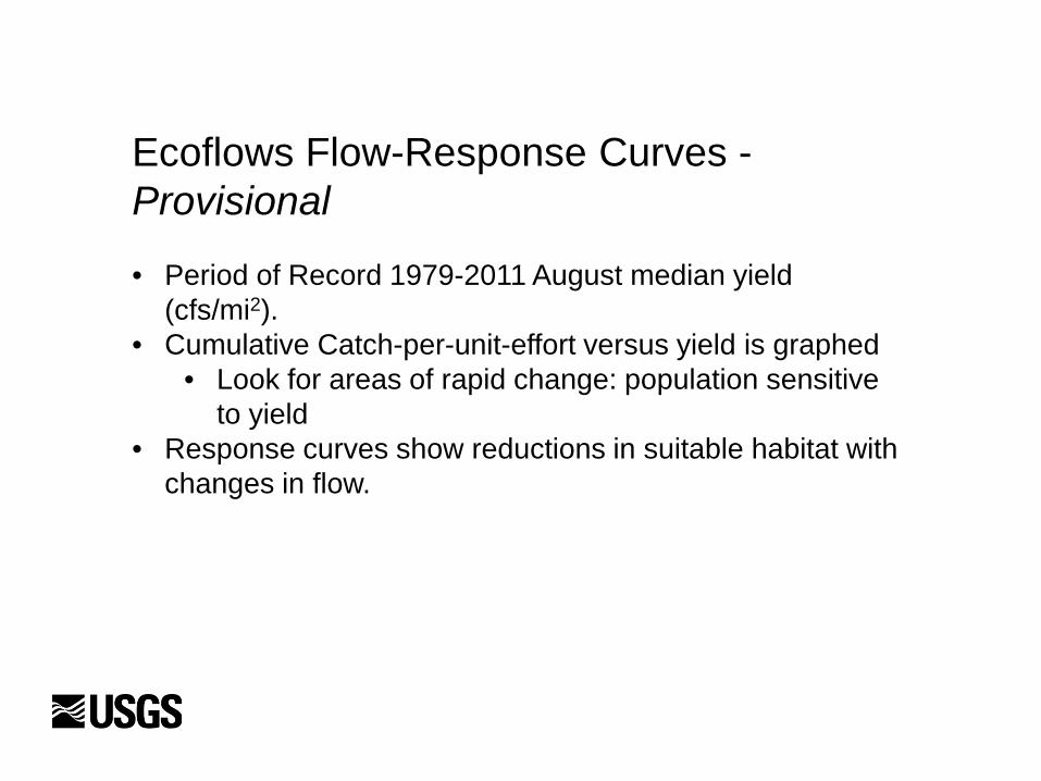
Ecoflows Flow-Response Curves - Provisional
• Period of Record 1979-2011 August median yield (cfs/mi2).
• Cumulative Catch-per-unit-effort versus yield is graphed • Look for areas of rapid change: population sensitive
to yield • Response curves show reductions in suitable habitat with
changes in flow.

All Records
Provisional: for illustration only

Provisional: for illustration only

Provisional: for illustration only
Resources Hamilton, D. A., and Seelbach, P.W., 2011. Michigan’s Water Withdrawal Assessment Process and Internet Screening
Tool: Michigan Department of Natural Resources, Fisheries Special Report 55, 37 p. (Also available at http://www.michigandnr.com/PUBLICATIONS/PDFS/ifr/ifrlibra/Special/Reports/sr55/SR55.pdf)
Hamilton, D.A., Sorrell, R.C., and Holtschlag, D.J., 2008, A regression model for computing index flows describing the median flow for the summer month of lowest flow in Michigan: U.S. Geological Survey Scientific Investigations Report 2008–5096, 43 p. (Also available at http://pubs.usgs.gov/sir/2008/5096/.)
Luukkonen, C.L., Holtschlag, D.J., Reeves, H.W., Hoard, C.J., and Fuller, L.M., 2014, Estimation of monthly water yields and flows for 1951–2012 for the United States portion of the Great Lakes Basin with AFINCH: U.S. Geological Survey Scientific Investigations Report 2014–5192, 83p, http://dx.doi.org/10.3133/sir20145192.
Reeves, H.W., Hamilton, D.A., Seelbach, P.W., and Asher, Jeremiah, 2009, Ground-water-withdrawal component of the Michigan water-withdrawal screening tool: U.S. Geological Survey Scientific Investigations Report 2009-5003, 36 p. (Also available at http://pubs.usgs.gov/sir/2009/5003/.)
Reeves, H.W., 2008, STRMDEPL08—An Extended Version of STRMDEPL with Additional Analytical Solutions to Calculate Streamflow Depletion by Nearby Pumping Wells: U.S. Geological Survey Open-File Report 2008–1166, 22 p. (Also available at http://pubs.usgs.gov/of/2008/1166/.)
Ruswick, Frank; Allan, Jon; Hamilton, David; and Seelbach, Paul, 2010, The Michigan Water Withdrawal Assessment Process— science and collaboration in sustaining renewable natural resources: Renewable Resources Journal, v. 26, no. 4, p. 13-18.
Steinman, A.D., Nicholas, J.R., Seelbach, P.W., Allan, J.W., and Ruswick, Frank, 2011, Science as a fundamental framework for shaping policy discussions regarding the use of groundwater in the State of Michigan—a case study: Water Policy, v. 13, no. 1, p. 69-86, doi: 10.2166/wp.2010.047
Zorn, T. G., Seelbach, P. W., Rutherford, E. S., Wills, T. C., Cheng, Su-Ting, and Wiley, M. J., 2008, A landscape-scale habitat suitability model to assess effects of flow reduction on fish assemblages in Michigan streams: State of Michigan, Department of Natural Resources, Fisheries Research Report 2089, 46 p. (Also available at http://www.michigan.gov/documents/dnr/RR2089_268570_7.pdf)
Zorn, Troy G., Paul W. Seelbach, and Edward S. Rutherford, 2012. A Regional-Scale Habitat Suitability Model to Assess the Effects of Flow Reduction on Fish Assemblages in Michigan Streams: Journal of the American Water Resources Association (JAWRA), 1-25. DOI: 10.1111 ⁄ j.1752-1688.2012.00656.x